Exploring Richard II’s treasure house – a tour round Holt Castle

Holt Castle was built in north Wales by John de Warenne, the Earl of Surrey, and dates from an age in which the country was transformed. Edward I’s campaign to conquer the Welsh in the 1280s led to the creation of towns and some of its most iconic castles.

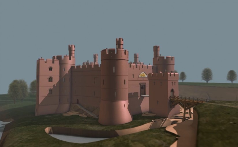
The great sandstone walls were once owned by royalty. Richard II confiscated Holt Castle in 1397 and under his ownership the castle was revitalised. It became one of his favourite properties and he used it as a treasure house, storing £40,000 there. If it wasn’t for the Civil War of the 17th century Holt’s unusual pentagonal design and imposing architecture would have made it as recognisable as Beaumaris, Caernarfon, or Harlech.

Instead in the 1640s Holt Castle was demolished and its stone used to build Eaton Hall. Centuries on, it is hard to picture how this once great castle would have appeared. To help with this the Castle Studies Trust supported Rick Turner and Chris Jones-Jenkins in digitally recreating Holt as it would have appeared around 1495.

If you have been following our work, you may already have seen in Current Archaeology or BBC History Extra how Rick and Chris brought together a range of sources to create this unique model. If you haven’t, those pieces are certainly worth a read.

It is important that what we do is available for everyone. That is why when our projects are complete you can find the results on our website. With this model it has even been published under an open licence so it is free to reuse. This can lead down some interesting avenues. One blogger, Megan Whalen Turner, even been called “A perfect starter home for Fantasy Authors”!

As well as video sharing websites we also uploaded it to Wikipedia. Until recently you could read about Holt Castle in English, Welsh, and Spanish. The video has inspired more interest, and now you can read about this 13th-century castle in French, Italian, Catalan, Finnish, Basque, and Swedish.

Want to know what we will be doing next? Sign up to our newsletter.

Small Unmanned Aircraft and archaeology – why now?

In 2015 the Castle Studies Trust and the Morecambe Bay Partnership worked together to record the remains of Gleaston Castle in Cumbria. By using an unmanned drone to photograph the castle we were able to reach every part of the building. Below is an excellent explanation from Museum of London Archaeology’s Dr. Peter Rauxloh of how this technique works. It was originally published on MOLA’s blog.

Archaeologists have known about the benefits of investigating archaeology from an aerial perspective for more than 150 years, arguably longer, but the day-to-day use of aerial survey in MOLA’s work has been hampered by cost.

The model drone was a very popular Christmas present last year; a clear indication that cheap aerial photography has arrived. The big innovation from the perspective of archaeological aerial survey is the arrival of affordable digital photogrammetric software and automated flight control.

Photogrammetry is the practice of taking measurements from images. It is based on the fact that the position of an unknown point in 3D can be calculated if it is viewed from at least two other known points. This is the principle of triangulation, as important to map makers in the 17th century, as it is today.

The software in question uses the principle of photogrammetry and applies it to the processing of digital images to create 2D orthomosaics and 3D models. In essence, the traditional technique of aerial photogrammetry used a small number of high quality images taken with expensive specialist cameras from real aircraft, on which a small number of common points were identified between adjacent images. The new method uses a large number of images, taken with a standard consumer grade digital camera from cheap aerial platforms and is able to identify thousands of common points between images. Thus the technique tightly locks together overlapping areas to create robust orthogonal mosaic and highly detailed 3D models.

The amount of overlap required between images in order to create robust models is very high, typically 75-85% between each successive image. This means that 85% of one image must still be visible in the next image, but how does one ensure that critical degree of overlap is maintained?

Typically an aerial survey will be flown in a grid, much like a tractor ploughing a field, and each successive image needs 75-85% overl ap with its predecessor. Moreover once it has turned and starts to fly back over the site, it must also get 60-70% overlap between the images on each leg. For small survey areas the aircraft is flown manually since it is easy to ensure the area is well covered with images,  but it is far more difficult to maintain the required consistency on a large site.  This is why MOLA use an autopilot and have it follow a flight plan.

A flight plan is a group of 3D coordinates or waypoints between which the aircraft navigates using its on-board GPS. To position these waypoints so the images overlap a number of variables need to be balanced. These include the camera’s field of view, frequency of image capture and the desired flight height and the speed of the aircraft. These in turn need to be considered against the size of the area to be flown and how long the aircraft can safely stay in the air.

Below you can fly round the model of Gleaston Castle.

Gleaston Castle
by aerial-cam
on Sketchfab