Understanding More About a C14 Nottinghamshire Mystery – Greasley Castle

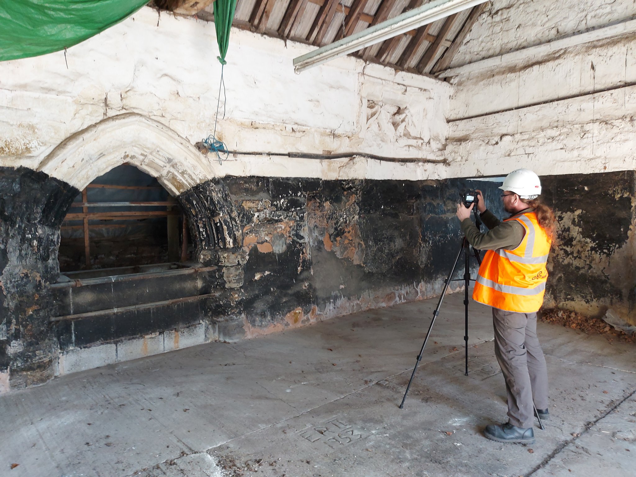
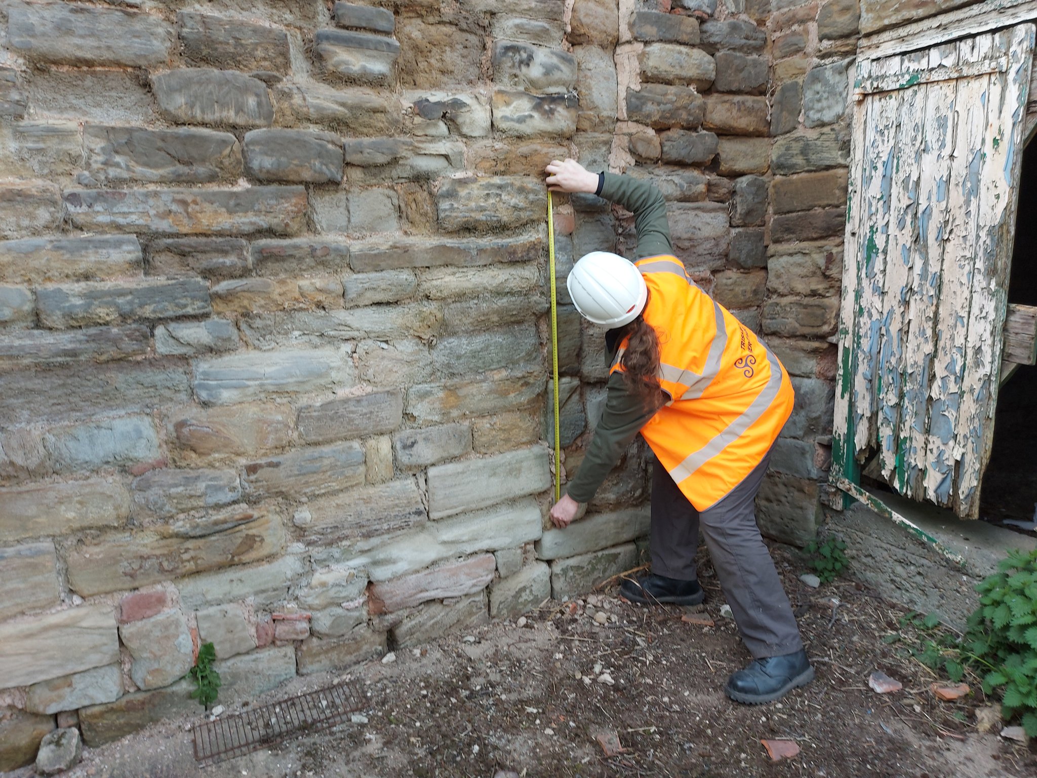
Back in January 2021 Triskele Heritage were successful in a funding bid to the Castle Studies Trust for carrying out a research project at Greasley Castle in Nottinghamshire. Here James Wright of Triskele Heritage explains what they hope to achieve with this project.

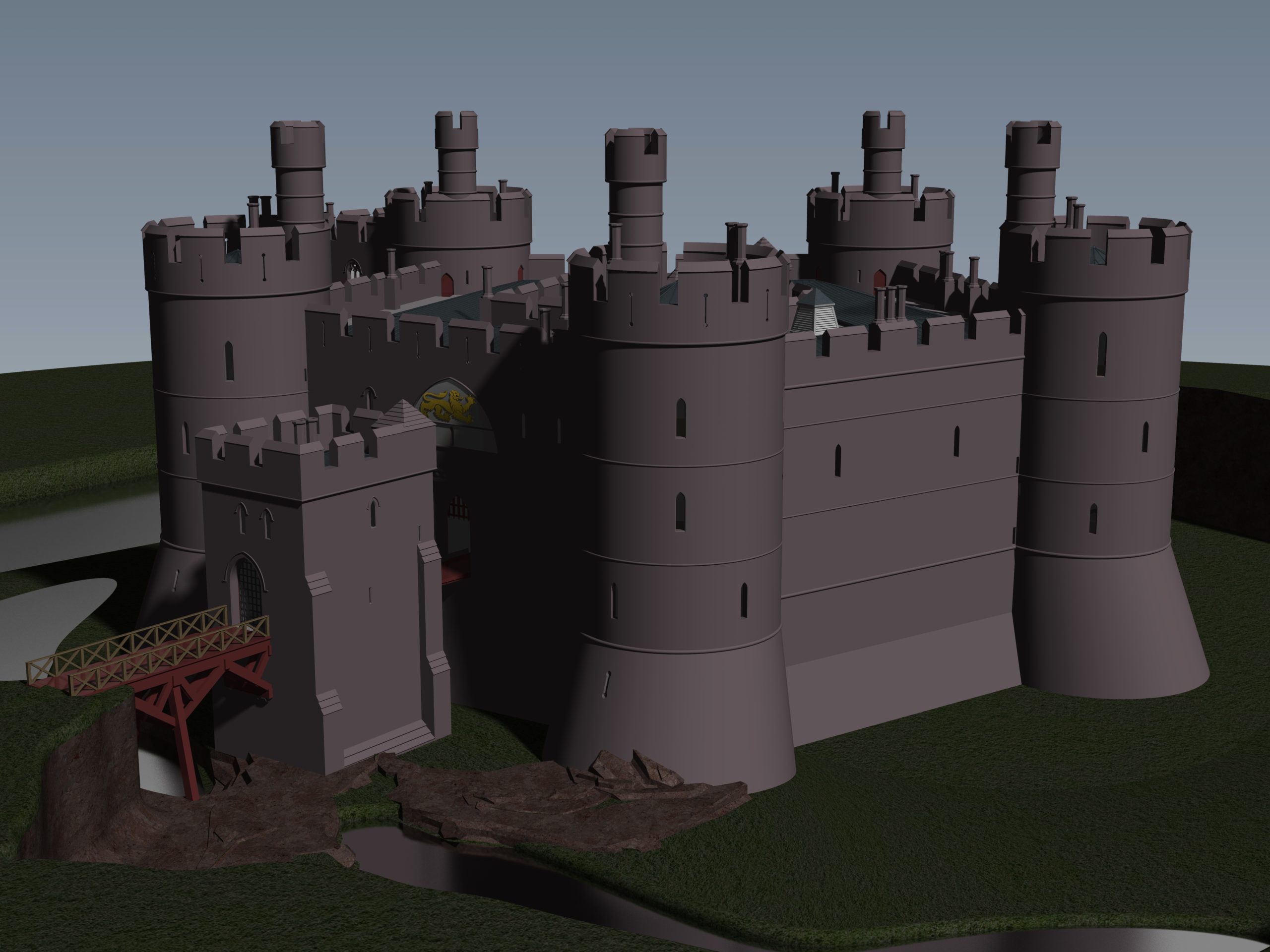
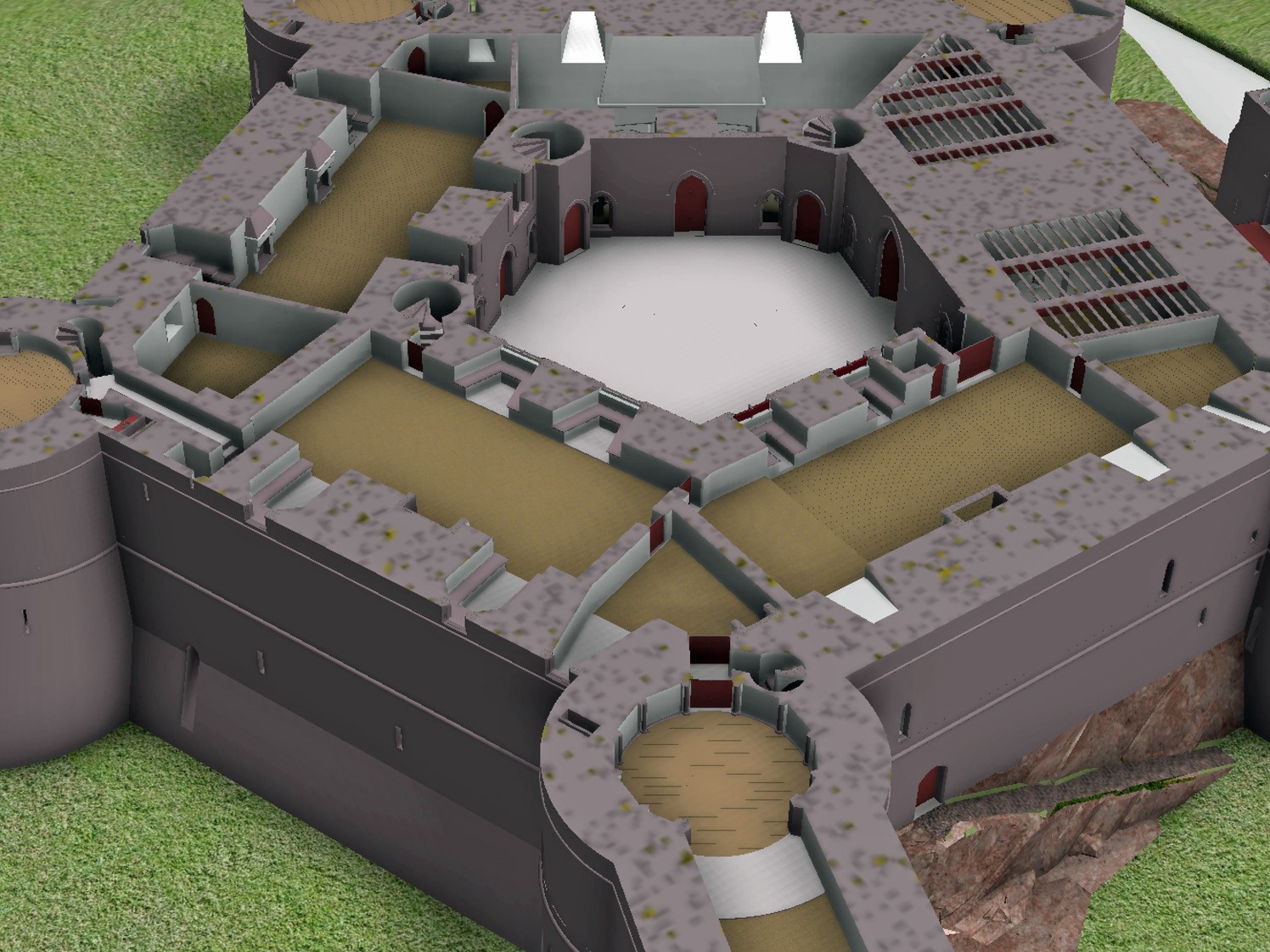
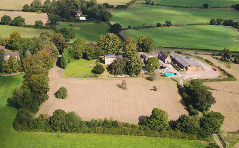
The work will focus on the production of an interpretative phased floor plan. The castle, built in the 1340s, has an obscure history and the understanding of its architectural phasing is at best very cloudy. The site is now a working farm and a number of post-mediaeval structures have been conglomerated around the remains of what is suspected to be a fourteenth century courtyard house with projecting corner towers.

Subscribe to our quarterly newsletter

The survey will act as baseline research data for a site which has not previously received serious fieldwork or publication. It will also provide a basis for further research and future conservation needs.

Work on the project will start in April 2021 and will be carried out by James Wright FSA alongside Dr Matt Beresford. We are supported in this endeavour by the landowners and Sarah Seaton of the Greasley Castle and Manor Farm History Project.

Greasley survey in action – photogrammetry

Project Background

Greasley Castle was developed for Nicholas, 3rd Baron Cantelupe (c 1301-55) after being granted a licence to crenellate by Edward III in 1340 (Davis 2006-07, 239). He was a significant figure who fought for the king in France and Scotland, served in parliament, founded Beauvale Priory and established a chantry at Lincoln Cathedral (Green 1934). Later owners of the site included John Lord Zouche – one of the few aristocrats proven to have fought for Richard III at Bosworth (Skidmore 2013, 330). After Zouche’s attainder, the castle was given to Sir John Savage in recognition for his military support of Henry VII in 1485 and remained in the family after his death at the siege of Boulogne (Green 1934).

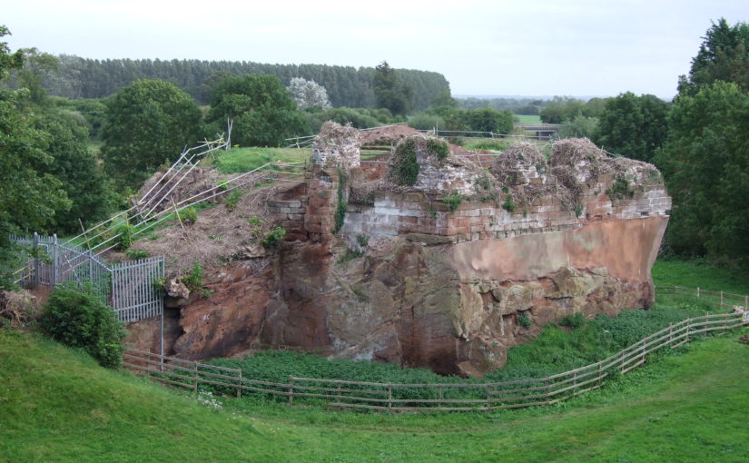
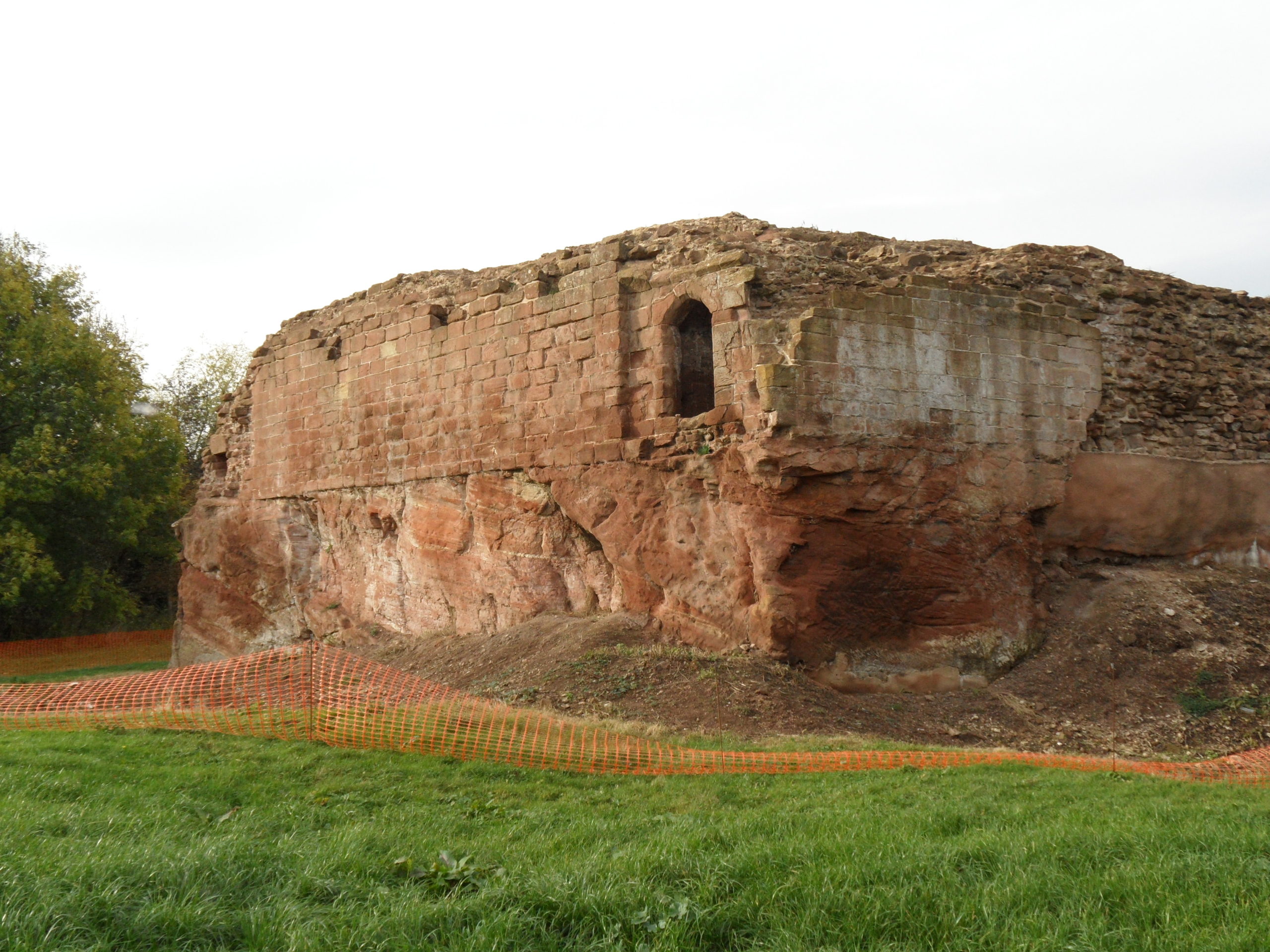
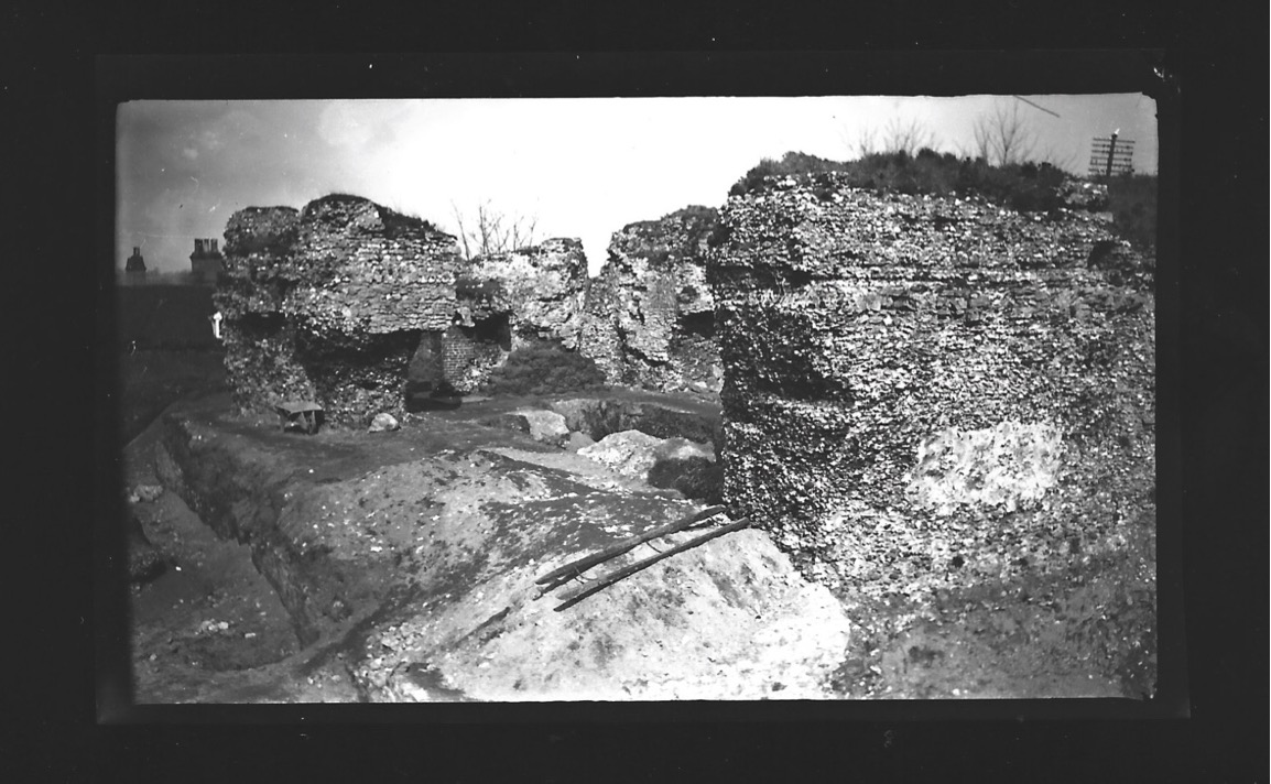
The site is now a working farm and comprises two grade II listed buildings (NHL 1247955 and 1248033) overlying a scheduled ancient monument (NHL 1020943). The buildings sit along the northern perimeter of a 5.18 hectare earthwork enclosure and comprise a multi-phased U-shaped group of structures with an adjacent farmhouse to the north-west. The layout of the site is not well understood, but very limited prior research indicates the potential for a courtyard house with projecting corner towers.

The most substantive work on site took place in 1933 and comprised just two days of rather inadequate and poorly reported archaeological evaluation (Green 1934, 34-53). During the mid-2000s the wider landscape of the site was considered by the East Midlands Earthwork Project (Speight 2006). Greasley is routinely mentioned in surveys of castles stretching as far back as the antiquarian Throsby (1797, 239-42) and the early castle scholar Mackenzie (1896, 448-49). Although these initial commentators were of the opinion that little or nothing remained of the mediaeval castle, twentieth century authors, including Pevsner (1951, 76), his later editors (Pevsner & Williamson 1979, 135), Sarah Speight (1995, 70-71) and Oliver Creighton (1998, 479), noted in situ structures. In the twenty-first century a number of writers have pointed towards the tremendous archaeological potential of the surviving mediaeval architectural features (Emery 2000, 327; Salter 2002, 85; Wright 2008, 49-50, 65; Osbourne, 2014, 39).

Greasley survey in action: measuring

Crucially, the potential of the site has never been realised. Green (1934) noted that ‘it is not possible to be definite’ about the ground plan of the castle; a point later confirmed by Creighton (1998, 479): ‘the deficiency of the field evidence renders the exact nature and extent… obscure.’ The confusion surrounding the floor plan of the castle has been created by an overall lack of fieldwork and publication on the site. The paucity of research has led to a number of conflicting statements regarding the buildings archaeology. For example, the National Heritage List notes that the farmhouse was built c 1800 and has later nineteenth century elements (NHL 1247955); however, the most recent Pevsner edition notes that it is a seventeenth and eighteenth century building ‘with earlier origins’ (Hartwell, Pevsner & Williamson 2020, 240).

The proposed project to accurately map, assess and date the overall floor plan of the structures at Greasley Castle is long overdue and such building recording of manorial centres is specifically called for by the East Midlands research agenda (Knight, Vyner & Allen 2012, 94).

Subscribe to our quarterly newsletter

Feature image copyright Neil Gabriel

References

Reconstructing Holt Castle, Denbighshire

Little physically now remains of Holt Castle, however, one of the first projects the Castle Studies Trust was for leading buildings reconstruction artist Chris Jones-Jenkins and the late and much missed Dr Rick Turner to digitally reconstruct the castle using a mixture of historical sources and recent archaeological excavations to bring the castle back to life with a series of images and a video fly through. Here, in a piece first published in History Extra in 2015 explains how it was done.

Subscribe to our quarterly newsletter

History:

To secure his conquest of north-east Wales, Edward I created five new Marcher lordships in 1282, and gave them as reward to his political allies and close friends in recognition of their loyal service. The lordship of Bromfield and Yale was granted to John de Warenne, sixth earl of Surrey (1231-1304). It is not known when he started building Castrum Leonis or ‘Chastellion’ as Holt Castle was known in the Middle Ages. The castle is first referred to in 1311 some years after it was probably completed. Warenne’s master mason chose an open and relatively flat site above the west bank of the River Dee, close to one of the ferry crossings into Cheshire. This allowed him to create a symmetrical pentagonal castle with a tall round tower at each corner, and the main rooms ranged around an inner courtyard. There were up to three storeys raised above the original ground level, with the moat and up to additional three basement levels cut down into the sandstone bedrock. It was a revolutionary design and was one of a group of similar architectural experiments being undertaken by the other new Marcher Lords at castles such as Denbigh, Ruthin and Chirk. At all these sites geometrical complexity, architectural grandeur and the provision of well-appointed accommodation seemed to be more important than their defensive capabilities.

Holt Castle as it was in its pomp courtesy of Chris Jones Jenkins

            The sixth earl was succeeded by his grandson John, the seventh earl of Surrey (1286-1347). Described by Alison Weir as ‘a nasty, brutal man with scarcely one redeemable quality’, he was involved with the political upheavals of Edward II’s reign, including the loss of Holt Castle for a time to Thomas, earl of Lancaster. This John died without a legitimate heir, and Edward III intervened to settle his estates upon Richard FitzAlan, third earl of Arundel (c.1313-1376). His son, Richard the fourth earl (1346-1397) was one of the ‘Lords Appellant’, who had curbed Richard II’s powers and had the king’s closest allies executed or exiled during the ‘Merciless Parliament’ of 1388. It took nine years before the king was able to wreak his revenge on these powerful men. Arundel was brought to trial for treason at Westminster on 21 September 1397, and was convicted and beheaded on the same day. Richard II seized his estates and incorporated Bromfield and Yale into his new principality of Cheshire, with Holt Castle as its main stronghold. Building work was commissioned in 1398, which saw the Chapel Tower extended and included a water-gate, called ‘Pottrell’s Pit’ in later documents, linked to the river. Over the next year more than £40,000 in coin, jewellery, gold and silver plate was transferred from the royal treasury in London to Holt for safe keeping. When Henry Bolingbroke – later Henry IV – returned to England in 1399, he shadowed Richard II up the Welsh Marches and was quick to recapture Holt Castle. Despite being defended by 100 men-at-arms and being well provisioned, Henry’s men, including the French chronicler Jean Creton, were able to enter through the new water-gate and ascend ‘on foot, step by step’, to take the castle unopposed and so recover this vast proportion of the king’s disposable wealth.

Subscribe to our quarterly newsletter

            Over the next 139 years, three more owners or stewards of the lordship of Bromfield and Yale were to be executed for treason. The first was Henry Stafford, second duke of Buckingham (1455-83). A year after his death, Sir William Stanley (c.1435-1495) acquired the lordship from Richard III. Despite his role at the Battle of Bosworth which brought his relative Henry VII to the throne, he was implicated in the Perkin Warbeck affair and was executed in 1495 after which Holt Castle reverted to the Crown. The last of this group was William Brereton (c.1487×90-1536) who was appointed steward of the castle where he held ‘great porte and solemnities’, before he was convicted of adultery with Anne Boleyn and beheaded.

            Holt Castle remained the property of the Crown and was to form part of the estates of the Princes of Wales. It was held for the king during the Civil War and in the 1670s, the buildings were sold off to Sir Thomas Grosvenor, who systematically dismantled nearly all the fabric and transported it to help in the building of his Eaton Hall, a few miles south of Chester. This has left us with the stump of rock and walling which survives today.

Reconstructing the Castle:

Two attempts have been made to understand the original the former appearance of Holt Castle: by Alfred Palmer in 1907 and Lawrence Butler in 1987. They had access to plans and views of the castle drawn in 1562 and 1620. The problem they faced was that these two sets of drawings are contradictory and they were hard to relate to what survived. Since 1987, new evidence has been made available:

  1. Documentary evidence for Richard II’s building work.
  2. The publication of a transcript of the Holt Castle inventory taken after Sir William Stanley’s arrest in 1495.
  3. The discovery of a new early-seventeenth century plan of the castle in the National Library of Wales.
  4. A programme of masonry consolidation, archaeological excavation and survey led by Steve Grenter, Wrexham County Borough Council, in partnership with the Holt Local History Society.

This new work prompted me to undertake another attempt to reconstruct Holt Castle. With the help of a grant from the Castle Studies Trust, I was able to commission the well-known castle reconstruction artist, Chris Jones-Jenkins, to develop a 3D digital model which was flexible enough to capture and assimilate the new data and modify the structure as new insights were gained.

The challenge has been to weigh each source of evidence and identify which strands should have precedence when contradictions emerge. A hierarchy was developed:

  1. The visible masonry of the castle and the modern topographical survey of the site provided the primary terrain model on which the remainder of the castle was constructed.
  2. The archaeological evidence for the rock-cut footings, the bases of three of the towers and the line of the channel leading into the water-gate provided other fixed points in the model.
  3. By considering the content and the potential reasons for the drawing of the three, early-modern ground plans and the two associated views, that of 1562 was assessed to be the most reliable for the details that it showed, the early seventeenth century plan for its dimensions, and those by John Norden of 1620 to be the most inaccurate, despite them being the ones most frequently published.
  4. The list of rooms and the route followed by the appraisers of the 1495 inventory provides the most comprehensive source for the internal layout of the castle. However, it became clear that those rooms without contents, such as the triangular ante-rooms to the towers and the latrines, were not listed.
  5. None of the views of the castle were architecturally detailed, and none showed all of the exterior or much of the inner courtyard. This information had to be derived from surviving details from other Edwardian castles in North Wales or from work undertaken in Richard II’s reign, when considering the projection from the Chapel Tower.
Holt First floor floor plan with with watergate to the fore and great hall and stable section to the right, copyright Chris Jones-Jenkins

The development of the model became an iterative process between the historian and the artist. Different combinations of layout and floor heights were tried, building on the fixed points surviving at basement level and rising up in an effort to accommodate all the rooms. Suites of accommodation began to emerge. Sir William Stanley’s great chamber led off the high end of the hall and controlled access in one direction to his counting house and the chapel, and in the other to the Treasure House and the High Wardrobe, where all the valuables were kept. Across the courtyard his wife, Elizabeth, had her own great and bed chamber, linked to the nursery. Above her accommodation was a chamber for her gentle women, well away from the yeomen’s dormitory under the lord’s great chamber. One range was dominated by the kitchen, rising the full height of the castle, connected at basement level to a larder, pastry house, well house and a wine cellar on one side and offices for the cook and butler on the other. As was normal the constable had a suite over the inner gate, but unusually a stable for 20 horses was created in a basement below the hall with access for the animals across the moat and up a ramp into the castle.

Holt Great Hall and Stables copyright Chris Jones-Jenkins

Working on this reconstruction, our admiration only grew for the original designer. He created a symmetrical plan and external appearance but produced complex internal arrangements to meet his patron’s needs. Holt is as much a chivalric ideal as a practical castle. An animation of the reconstruction of Holt Castle has been produced by Mint Motion of Cardiff and can be viewed here:

Subscribe to our quarterly newsletter

Feature image courtesy of Wrexham Borough Council

Unearthing past excavations of Bungay Castle

Dr Lorna-Jane Richardson, University of East Anglia/Bungay Museum, looks at the 1930s excavations of Bungay carried out by Hugh Braun and also the possibility of future work at the site.

Bungay is a small market town on the border of Norfolk and Suffolk, and sits on a meander in the River Waveney at the very edge of the Norfolk Broads National Park. The town is in a good defensive position, sat on a sand and gravel river terrace, some 10 metres above OD, with wide views across the valley and surrounded by marshland. This ‘natural fortress’ (Braun 1934) had seen earlier, perhaps early Medieval, defensive structures built, suggestive of a burh. This site was chosen for the construction of a castle firstly by one of William the Conqueror’s stewards, William de Noyers, who constructed a motte and bailey structure. The castle was bestowed on Roger Bigod, a Norman knight who was awarded estates in East Anglia and given Bungay in 1103 by King Henry I. Roger’s son, Hugh, known as Bigod the Restless, was made Earl of Norfolk in 1154, and he ordered the construction of the stone keep. The Bigods were the most powerful family in East Anglia for much of the 12th and 13th centuries. After nearly two centuries in the hands of the Bigod family, who also owned Framlingham Castle further south in Suffolk, Bungay Castle reverted to the Crown and fell into disuse. In 1312, Edward II gave the Castle to his brother, Thomas Plantagenet, and it eventually passed to the Dukes of Norfolk in 1483. However, it was recorded as being ‘ruinous’ by 1362, and over the subsequent centuries, the site was used as a source for building materials, the gatehouse was converted into a residence for an eighteenth-century novelist, and the keep was also used as a beer garden by the King’s Head Inn at least until the early 1930s.

Dr Leonard Cane directing excavations at Bungay Castle in 1934

A group of Bungay dignitaries, led by the Town Reeve and local doctor Leonard Cane, leased the site from the Duke of Norfolk, and on 19th November 1934, the excavation of the site commenced. This excavation took place under the leadership of Dr Cane and Hugh Braun, an architect from London who had worked in Iraq with the Chicago University Expedition at the site of Nineveh. The excavation provided work for unemployed war veterans and interestingly, engaged the services of a local water diviner, one Mr John Davey who can be seen in Fig 2, to locate water and gold during the excavations. Further research is underway in an attempt to discover more about these veterans, and the role played by Mr Davey and his water-magic.

The excavations initially concentrated on the area between the keep ruins and the gatehouse, and around the keep itself, revealing buried walls which “would show the castle rising some twenty feet higher than before the excavation commenced” (Braun 1991, 23). The drawbridge pit was excavated, and the west wall of the keep was exposed, but other areas of the gatehouse and keep were left intact, after the excavation ran out of funds. Some of these areas were, according to Braun’s report, tidied and returfed ready for further exploration at a later date. These areas remain untouched, and no further excavations in the area of the gatehouse or keep have taken place since 1934. The excavations were subsequently published in the Proceedings of the Suffolk Institute of Archaeology and History in 1934, 1935 and 1936. There have been no further major archaeological excavations, although some unpublished monitoring work took place in 2001, 2006 and 2008 according to the HER, and geophysical work took place at the Castle in 1990 (Gaffney & Gater) and 2017 (Schofield). In 2017, what is now Cotswold Archaeology Suffolk undertook a detailed geophysical survey of the area of the inner bailey, which demonstrated very high potential for archaeological material and structural remains. These include evidence for buildings, a potential well, and a variety of pits some of which feature ferrous debris. Bungay Castle holds much potential for further archaeological work.

Map of the Castle Motte (Braun)

These photographs are from the Braun/ Cane excavations at Bungay Castle and are dated to 1935. They are part of the Bungay Museum collection, and there are around 40 images which feature the excavations, the people involved, and a variety local dignitaries and visitors to the site. In January 2021, I became curator of Bungay Museum, which was originally established in 1968 by Dr Leonard Cane’s son, Dr Hugh Cane. As part of this role, I plan to undertake further research into the contents of the museum collection, local contemporary news articles about the excavations, as well as Ministry of Works documents held at Kew, in order to develop new displays about the site and Bungay’s very own version of ‘The Dig’. Basil Brown himself would have certainly visited the excavations, as he lists the site in his notebooks, and he lived relatively locally. I hope my research will reveal more information about the names and lives of the veterans who dug the site, how the excavation was managed and run, more about the archaeological finds, and the mysterious role of water divination in the process. There are many interesting stories waiting to be told about the original excavations at Bungay Castle, and many more are waiting in the wealth of archaeology that remains in the ground.

1935 excavations in the Castle Keep

Subscribe to our quarterly newsletter

Feature image: Bungay Castle copyright Andrew Atterwill

References

Braun, H. (1934). “Some notes on Bungay Castle”. Proceedings of the Suffolk Institute of Archaeology and Natural History XXII.1, pp. 109–119.

— (1935). “Bungay Castle, report on the excavations”. Proceedings of the Suffolk Institute of Archaeology and Natural History XXII.2, pp. 201–223.

Braun, H. and G. Dunning (1936). “Bungay Castle: Notes on 1936 excavations and on pot- tery from the mortar layer”. Proceedings of the Suffolk Institute of Archaeology and Natural History XXII.3, pp. 334–338.

Gaffney, C., and Gater, J. (1990). Report on Geophysical Survey, Bungay Castle. Geophysical Surveys Bradford, Report 90/60.

Schofield, T. (2017) Bungay Castle, Bungay, Suffolk BUN 004 Geophysical Survey Report. Suffolk Archaeology Community Interest Company Report No. 2017/078.