Caerlaverock and the impact of Medieval storm surges

As Drs Richard Tipping and Eileen Tisdall along with Dr Tim Kinnaird of St Andrews return to Caerlaverock to carry out their final piece of field work this Saturday (2 October), Richard Tipping discusses what has happened so far.

Background

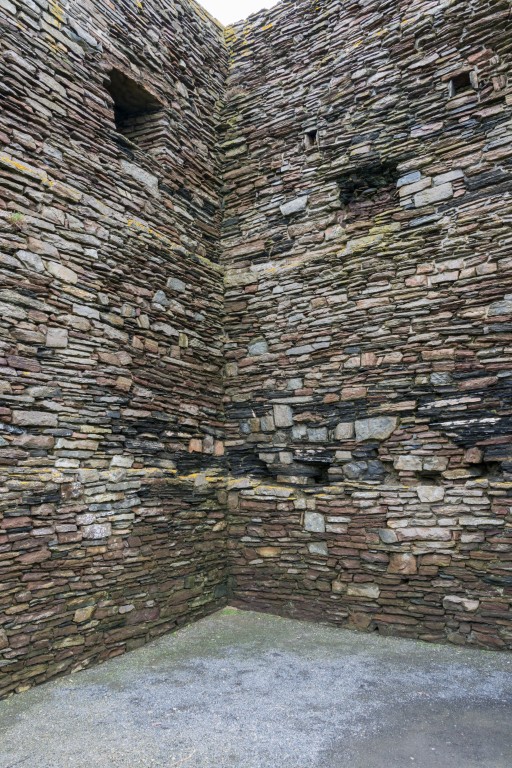
Earlier blogs have described the fieldwork, over the summer, at the Old Castle at Caerlaverock in south west Scotland. We have been testing the idea that several very large storm surges impacted the castle, persuading the occupants to re-build, higher up and further inland. That fieldwork involved recording sediments in the moat (Figure 1) and surrounding ditches, confirming that these sediment traps are full of silt derived, we think, from storm surges pushing sediment from the coast, through the harbour and into the moat. We’re checking the origin of the silt from diatom analyses, which can define water salinity. But we hadn’t found evidence that these storm surges were destructive, impacting archaeological features. Now we think we have.  

Subscribe to our quarterly newsletter

Setting

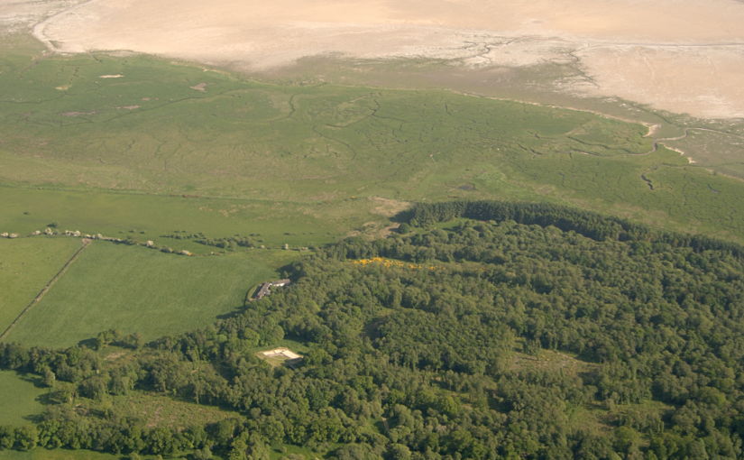
The ‘park pale’ is the name given to a ditched-&-banked enclosure that extends west from the harbour at the old castle for several hundred metres (Figure 1). It was constructed along a small cliff that marked the medieval coastline, separating mid-Holocene estuarine sediment, called ‘carse’ to its north and a series of very broad, parallel east-west trending ridges and basins constructed by medieval storm surges to its south (Tipping and Adams 2007).

Figure 1. Natural and archaeological features near the ‘park pale’ at Caerlaverock.

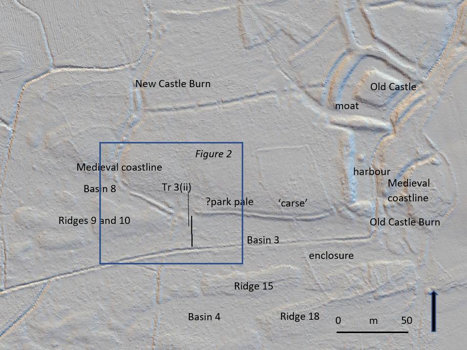
In Figure 1, a LiDAR image, Ridges 9 and 10, and Ridges 15 and 18 are seen. Between them, lagoon basins were trapped: Basins 8, 3 and 4 here. Some basins will be radiocarbon dated because peat formed when they were isolated from wave action. 

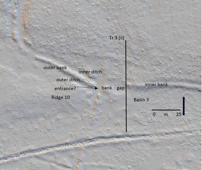
In detail (Figure 2) the ‘park pale’ is complicated. There is an inner bank to the east, with a crest around a metre higher than the ground to its south. This is lost at a 25m wide gap and cannot be traced further west. Instead, a second, lower outer bank continues north west to the New Castle Burn (Figure 1). The outer bank has, in places, an outer and inner ditch. Another, 4m wide gap may be what Brann (2004) thought was an entrance.

Tr 3 (ii) is the line of a 50m long sediment-stratigraphic transect of 24 hand-sunk boreholes from the ‘carse’ in the north, which the inner bank rests on, south across Basin 3 to the canalised Old Castle Burn. The transect was designed to test the idea that the 25m gap in the ‘pale’ is an erosional feature from storm surge impacts.

Figure 2. Features around the distinctive 25m wide gap in the ‘pale’

Stratigraphy

What Tr (ii) shows is that the low ground of Basin 3 is floored by bedrock less than a metre down. This is covered by well-sorted sand and then by poorly sorted coarse to very coarse sand and grit with common pebbles.This fills Basin 3, thickening shoreward. This is interpreted as a storm surge deposit, deposited in a high-energy marine environment. Boreholes on the inner bank, a metre higher than Basin 3, and 25m inland, also recorded thick gravelly sand, impenetrable at 90cm depth on the inner bank. This thins north but is still found 20m inland from the medieval coastline.

Narrative

There were at least two storm surge ridges formed before the events recorded in Basin 3. Basin 8 (Figure 1) was formed by the second storm surge, as yet undated. This created Ridges 9 and 10. These broad gravel ridges in turn protected the western ‘park pale’ from subsequent marine erosion (Figure 2). What is now the outer bank, with its associated ditches, probably represents the original boundary of the ‘pale’. The ‘pale’ pre-dates the storm surge event described here. It is shown by the sediment stratigraphy to be, broadly, medieval in age and, broadly, contemporary with the old castle.

Eastward, Ridges 9 and 10 merge with the ‘carse’ of the medieval coastline, leaving this part of the coast vulnerable to later storm surges. At this point, the outer bank of the ‘pale’ is lost. In its place are storm surge sediments. The ‘pale’ was eroded by the storm surge. This storm surge pushed at least 90cm of gravelly sand north onto the surface of the ‘carse’. The cliff may have been formed after this storm surge, by later erosional wave action. Gravelly sand was pushed or thrown 20m beyond the cliff. Waves also scoured the easily eroded ‘carse’, lowering the surface by around 0.5m, up to 100m inland.

 Subscribe to our quarterly newsletter

References

Tipping, R. and Adams, J. 2007. Structure, composition and significance of medieval storm beach ridges at Caerlaverock, Dumfries & Galloway. Scottish Journal of Geology 43, 115-123.

Old Wick: Removing the Joist

On Wednesday and Thursday 22nd and 23rd of September, a team lead by Rachel Pickering of Historic Environment Scotland and Coralie Mills undertook to remove the remains of wooden joist from the keep at Old Wick Castle. The joist hole was 8 metres above ground level. If successfully removed the joist was then to be taken away for testing and hopefully provide a date for it and the castle. In a slightly different blog than usual here are three short videos looking at how the removal process went.

Subscribe to our quarterly newsletter

Below Rachel Pickering and Coralie Mills on day one explaining what they have found:

In the second video we see Coralie Mills and her colleague Hamish Darrah attempting to remove the joist from its socket

While in the third video Coralie and Hamish give their initial thoughts on the newly extracted joist:

Subscribe to our quarterly newsletter

All videos courtesy of Rachel Pickering of HES.

Testing time at Castle of Old Wick, Caithness

As the Old Wick project gets underway, the project lead Rachel Pickering of Historic Environment Scotland explains what they are trying to find out and how.

In the far northeast of mainland Scotland, on a narrow promontory, surrounded by cliffs on three sides, stand the ruins of Castle of Old Wick. The castle is one of Caithness’ most striking medieval sites due to its rugged location. But time has not been kind to the castle, and all that survives above ground is the stark stone skeleton of a once grand tower, within low-lying earthworks on the promontory behind. There are many unanswered questions about this castle, not least ‘when was it built?’.

Subscribe to our quarterly newsletter

Castle of Old Wick in its dramatic coastal setting. © Crown Copyright HES

Very little is known about the castle’s origin and development – there is limited documentary evidence relating to its earlier history and no diagnostic architectural features survive, making it very difficult to date. It was once thought to have been one of the earliest stone castles in Scotland, associated with Norse earls of Orkney and Caithness. However, more recently, scholars have questioned this, suggesting a 14th century date is much more likely for its construction.

Reconstruction illustration showing how the castle and its surrounding outbuildings may have looked at its height. © Crown Copyright HES.

One tantalising clue survives that may shed light on its construction history – a single fragment of timber within a joist socket of an upper floor. The image below shows these joist sockets which indicate the tower had timber floors throughout. The sole surviving timber is increasingly at risk of decay as it is exposed to the elements. Our aim is to remove the timber and assess it for dendrochronological analysis – or tree-ring dating, before conserving the remains. From this we may be able to get a scientific date to indicate when the castle was built. At the very least, such a date may provide an age and provenance for the timber joist which provides an insight into phases of the castle’s development.

Interior of Castle of Old Wick showing joist sockets indicating the location of first and second floors. © Historic Environment Scotland.

Thanks to generous grant funding from the Castle Studies Trust, HES and specialist contractor Dr Coralie Mills of Dendrochronicle will be carrying out new research this autumn, with the hope of recovering dating evidence.

The timber is believed to be oak, making it suitable for dendrochronological analysis, though it is in a very fragile state. It will be accessed using a scaffold and very carefully removed and wrapped before being transported to the laboratory in Edinburgh for detailed examination. Its condition and suitability for dendrochronological analysis will then be assessed. If it is not possible to analyse the rings of the timber due to its condition, then an alternative method will be undertaken using radiocarbon ‘wiggle matching’. This would involve taking several samples for high precision radiocarbon dating, allowing for a more accurately calibrated radiocarbon date for the timber.  

We hope this research will shed light on the construction and development of Castle of Old Wick, by providing valuable scientific dating evidence. The project will also potentially support the on-going development of dendrochronological analysis within Scotland, as every new analysis can help to add to and refine existing tree-ring chronologies, which in turn supports future research.

Subscribe to our quarterly newsletter

Defending Bedfordshire – a late starter

In the latest in is “Defending…” series looking at the fortifications in particular counties, Mike Osborne looks at Bedfordshire.

When I wrote Defending Lincolnshire: a military history from the Conquest to the Cold War (The History Press, 2010), I had no idea that ten years on, the series would have grown to cover ten counties with an eleventh almost completed. What I have discovered along the way is that while there exist clear cultural similarities, counties are patently different in so many regards. Some of these differences are obvious: the landscape factors which affect settlement patterns; the geology which dictates building materials and factors such as moated sites; the county’s relationship to important routes and its density of urban or rural settlements; its central or remote position within the nation; its relative vulnerability to invasion; and, above all, its recorded history. Other differences are more subtle and may be governed by local conditions and circumstances: the dominance of particular families or factions; the power struggles of kings, nobles or bishops; the economic effects of trade or farming; fashion and technology; continuity and re-use of defensive locations and the impact of localised, country-wide or international conflict. Taking the wider context of these studies which embrace all forms of fortification and military activity from Iron Age forts to nuclear bunkers, then such differences will only be magnified. 


The motte at Cainhoe (copyright Mike Osborne

Bedfordshire is unusual in that whilst there were Romano-British settlements and an established network of Roman roads: Watling Street, Ermine Street and the Icknield Way, there were, apparently, no Roman forts. Bedford became established only in Saxon/Danish times, owing to its strategic position astride the Great Ouse, and Clapham’s church-tower, on the border of Wessex and the Danelaw may well have served a defensive function. Sadly, despite the public promotion of Danes Camp at Willington and Tempsford as Viking river-side fortresses, they have both been found to be medieval moated sites. Luton only developed after the Norman Conquest becoming the location for two earthwork castles. A ‘royal’ castle was established at Bedford, soon to evolve into a masonry fortress, but the county’s numerous motte castles, notably Cainhoe, Yielden, Risinghoe and Totternhoe, and its fewer ringworks, whilst remaining as structures of earth and timber throughout, nevertheless often occupied dominant sites. Historical factors around conflict saw Bedford erased as a fortification early in its career having undergone two sieges, and most of the other castles would be superseded by more comfortable accommodation. The county was split into an unusually large number of small manors which may account for the over twenty earthwork castles and the 300+ homestead moats- the greatest density of any English county- benefiting from the underlying clay. Bedfordshire’s later medieval castles, Wrest Park, Bletsoe and Ampthill, have disappeared, but remnants of Someries survive to the background sound, in normal times, of Easyjet. Whilst largely insulated against external threats, the county still experienced the effects of conflict during the civil war between Stephen and the Empress and the Wars of the Roses, whilst suffering its share of the universal effects of famine, plague and social disorder. Probably the best-known castle-related event was the siege of Bedford by Henry III in 1224 which resulted in the destruction of the castle but not, in all likelihood, the draconian penalties reputedly enacted against the garrison.

Someries Castle: the gate-house/chapel range of the mid-fifteenth-century brick strong-house of Sir John Wenlock (copyright Mike Osborne)

Were anyone to ask me which of these counties had been the most interesting, given their differences, I should be pushed to answer. From the perspective of fortification, some will share similarities: Essex, Norfolk, and Hampshire as targets for invasion; the Midland counties of Nottinghamshire, Northamptonshire and Leicestershire/Rutland controlling lines of communication from urban centres; Bedfordshire, Lincolnshire and Cambridgeshire sharing elements of landscape; whilst London has a bit of everything as, I am currently discovering, has Gloucestershire and Bristol. All of them have interesting facets either shared or individual, common or unique. Rob Liddiard, amongst others, has confirmed to me the value of the local focus alongside other approaches, and it is certainly something I will continue to explore.

Subscribe to our quarterly newsletter

Defending Bedfordshire: the military landscape from pre-history to the present (Fonthill Media, 2021) is now available along with other counties.

Captions

Featured image: A model of how Bedford Castle may have appeared around the time of the siege of 1224


Recent discoveries at Shrewsbury Castle

With the 2020 excavation report now published, Shrewsbury Castle Excavation Director Dr Nigel Baker looks back at the two years of excavations and what they reveal about this important castle of the Welsh Marches.

Before the excavations in 2019 and 2020 funded by the Castle Studies Trust, Shrewsbury Castle was one of the least well understood major castles of the Welsh Marches. Its visible form is that of a classic motte-and-bailey, with earthen ramparts surmounted by stone curtain walls. However, the archaeological project and associated research has shown that the historical reality is more complex than this.

Subscribe to our quarterly newsletter

First recorded as a consequence of being besieged by local rebels in 1069, many aspects of its recorded history follow a familiar Marches pattern: heavy royal expenditure in the 12th and 13th centuries as a campaign base and in the face of Welsh raiding, followed by decline into obsolescence and ruination in the 14th, 15th and 16th centuries, arrested temporarily by a return to active service in the English Civil War in the 1640s. Its later history was as a private residence, distinguished by its ‘restoration’ by Thomas Telford in 1786-1790, and finally its return to public life as a council meeting hall in 1925 and as the home of a regimental museum in the 1980s.

First of all, the Norman castle was not built on an empty site. It occupied the end of a ridge that was critical to the defence of the old Saxon borough, and the 2019 excavation demonstrated occupation here in the 10th or early 11th century, on a plateau or low knoll at about 68m AOD, higher than its surroundings, and at one end of the likely cross-peninsula borough defences. At present the archaeological evidence is limited to a single pit and its artefacts, but reading between the lines of the historical record, it is possible that the site was shared by a church dedicated to St Michael and perhaps a hall, maybe that of the pre-Conquest sheriffs.

Plan of Shewsbury Castle as it may have appeared in late 11th / early 12th century copyright Dr Nigel Baker. The black lines indicates probable masonry curtain wall lines, based on the presence of the ‘green slabby rubble’ masonry that appears at various junctures at the bottom of some elevations and seems to be early, meaning potentially pre-13th

The Norman castle of the 1060s wiped out all that had been there before, except the church, which appears in Domesday Book; this also records the loss of 51 tax-paying households when the castle was built. It consisted of a large motte overlooking the river, elevated to a height (80m AOD) equal to that of the royal and episcopal halls within the old borough, with a substantial ditch, discovered in 2019, around its base. West of the motte was a small inner bailey. Extending south was a much larger outer bailey, separated from the English borough further south by a second cross-peninsula ditch and supplemented in the 12th century by earth ramparts around the bailey perimeter. The small size of the inner bailey, in reality perhaps more of a barbican, suggests that the royal hall, documented from 1246 but probably present from the beginning, was on the motte top.

It is not yet clear when the earth and timber defences began to be replaced in stone, but stretches of thin, slabby rubble in the curtain walls and motte wing walls may be indicative of work in the late 12th or early 13th century.

Major changes took place throughout the 13th century, some documented, some suggested by the excavations. The single surviving medieval building, often called the hall, is fairly certainly the camera regis or royal chamber built in 1239-41, a date consistent with the dendrochronological evidence from the building. It may have been constructed as part of a larger rebuilding campaign that saw the west side of the inner bailey expanded westwards by pushing a terrace out over the gradient behind a newly-built ashlar curtain wall. This is one of the conclusions of the 2020 excavation trench through the western rampart, which found medieval tipped strata at a level below that of the natural gravel seen in the interior of the bailey in 2019.

Plan of Shrewsbury Castle in late C13. Copyright Dr Nigel Baker

Meanwhile, the east side of the motte was subject to erosion by the River Severn and the consequent partial collapse of the motte was recorded by an enquiry held in 1255; in 1269-71 a ‘great wooden tower’ fell down and was said to be totally destroyed. The motte top was repaired towards the end of the 13th century with a new wall built across the damaged side in red and white striped masonry. The motte ditch appears to have been infilled, mainly by the deposition of rubbish, and a new castle well, which survives, was dug within it.

As the town grew, the outer bailey was built over. In 1220-c.1250 when the town walls were built, the outer bailey was walled continuously with the rest of the town and no longer separated from it; the tenements that had been established there continued to pay their ground rents to the crown while those outside, further south, paid theirs to the borough.

Two early plans show what had become of the castle by the end of the 16th century. The Burghley Map of Shrewsbury of c.1575 shows the main building unroofed, a smaller building (perhaps St Michael’s) in ruins, and just one roofed building standing in the inner bailey in the area of the surviving well. A sketch plan by the master mason John Smythson of 1627 likewise shows the main building, and most of the curtain walls, in a ruined condition; it also shows a gatehouse of which there is no other evidence.

Restoration came in 1643-44 when the castle was garrisoned by the Royalists, and the borough’s mayoral accounts record expenditure on the main gate and its new barbican, a new postern gate, walls and outworks. The castle was captured for Parliament in February 1645; what appears to be battle-damage can be seen on the woodwork of the main gate and around the openings of the main building but this identification now needs confirmation by battlefield archaeologists. After its capture, the Parliamentarians continued the Royalists’ restoration of the main building, its roof and gallery built with timber felled in the winter of 1647. The castle was finally de-munitioned in 1686 and became a private residence.

Shrewsbury Castle in 18th Century, note on the wall on top of the motte the possible base of windows of a high status building / Great Hall.

Thomas Telford’s ‘restoration’ of the castle in 1786-1790 for Sir William Pulteney was nothing if not brutal. The excavations in the inner bailey have shown that the interior was levelled down, scraped bare, and at least some of the material used to enhance or even create the ‘ramparts’ around the perimeter. Illustrations show that, until 1786, the motte top was still occupied by a 13th-century round tower and the ruins of other, as yet unidentified, buildings. These were all swept away and replaced by Telford’s ‘Laura’s Tower’, a fine, two-storey summerhouse in the Gothick style.

Subscribe to our quarterly newsletter