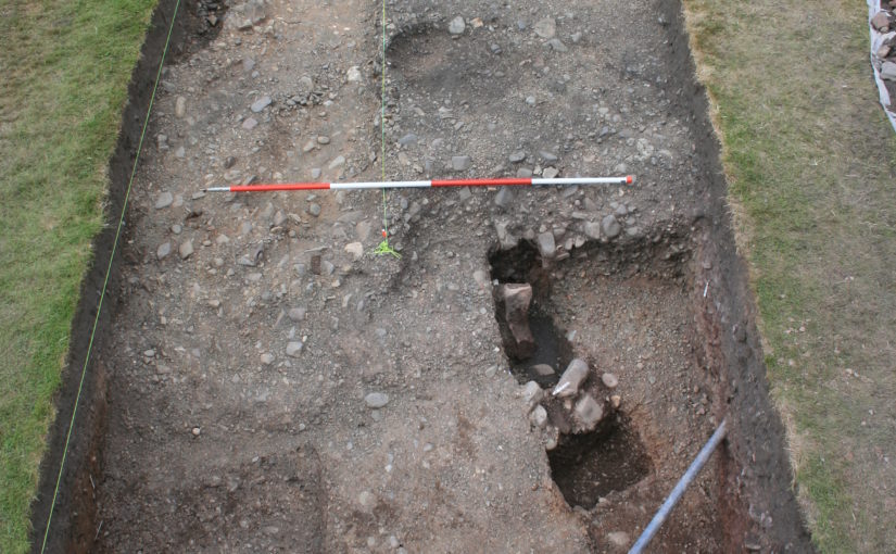
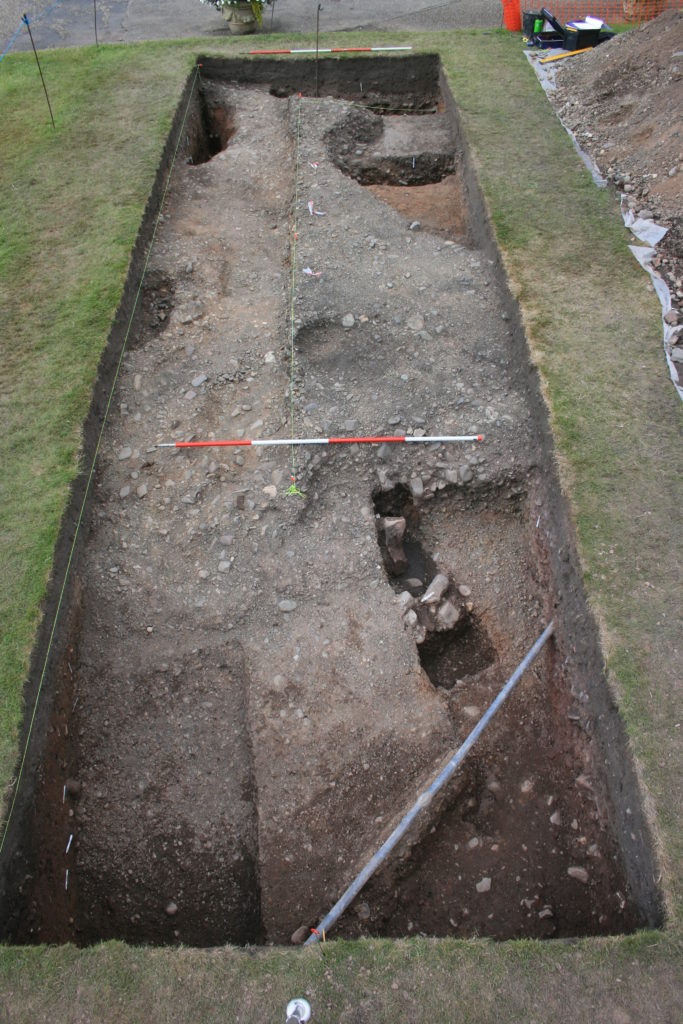
Where Power Lies: the archaeology of transforming elite centres in the landscape of medieval England c. AD 800-1200

Between 2018-2021 the Castle Studies Trust awarded three grants totalling less than £5,000 to Dr Duncan Wright of Newcastle University to develop a new methodology to understand the transition from Saxon to Norman rule at elite sites using Laughton-en-le-Morthen in South Yorkshire as an case study. This was then used to successfully win an early career research grant from the Arts and Humanities Research Council in 2022. Here is an update from Duncan about the project.

For the past 14 months a team from Newcastle University and the University of Exeter has been carrying out the first project dedicated to understanding the archaeological evidence for the origins of medieval power centres in the landscape of rural England. Where Power Lies has explored data at a number of scales, with a particular focus on places where elites developed a residential and ecclesiastical component in a single enclave. Importantly, the chronological remit of the programme straddles the Norman Conquest, allowing us to see with greater clarity the way in which castles were integrated and, in some cases, disrupted existing patterns of aristocratic activity and investment.

Subscribe to our quarterly newsletter

Among the first work packages initiated by the project team was a national GIS (Geographic Information Systems) of all of the ‘big data’ evidence for lordly centres, including the Corpus of Romanesque Sculpture in Britain and Ireland, and locations of the earliest castles. From this nationwide picture, the project targeted two ‘macro’ study regions, one focussed on the South/Southwest, and a second in North-East England. The Historic Environment Records for each county in the macro regions was then mined for useful data, helping us to identify a large number of new sites and to some extent map regional trends and differences in medieval elite activity. While such datasets must always be treated with care, this work immediately showed the frequency with which lordly complexes incorporate or are adjacent to watermills, strongly suggesting that mills and milling were central not just in the siting of aristocratic cells but also in the economic and symbolic foundations of elite power from the outset.  
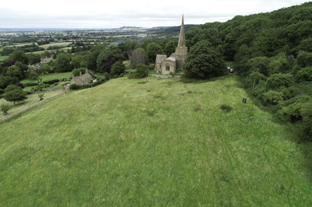
Figure 1: Aerial view of St Nicholas, Saintbury, and the earthworks to the west of the church. The complex has formed a key case study for the project copyright Where Power Lies

Where Power Lies has also conducted a programme of more comprehensive study focused on individual lordly centres. As a result, the project has been able to reconstruct something of the earliest phases of these places, identifying both commonalities and distinctions in what is usually seen as a homogenous category of archaeological site. One of the project’s main case studies has been Saintbury, Gloucestershire, where a series of prominent earthworks lie immediately south-west of the Romanesque church of St Nicholas (Figure 1). Despite the correlation of early church and impressive earthworks, almost no previous study had been undertaken at Saintbury until the Where Power Lies team conducted fieldwork in three phases in 2023; geophysical and standing building survey were conducted in July, excavation for optically stimulated luminesce (OSL) profiling and dating samples in September, and topographic survey and 3D modelling via drone in November.
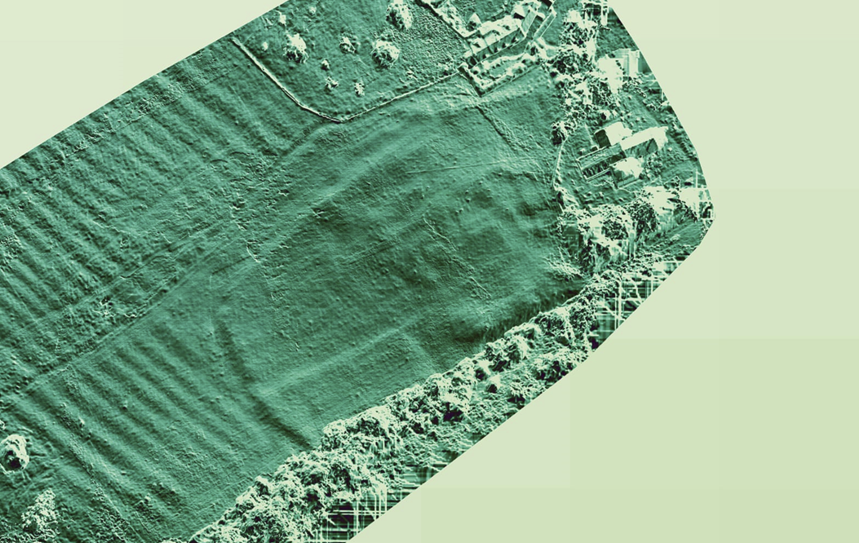
Figure 2: Topographic model derived from drone data of St Nicholas, Saintbury, and the earthworks west of the church. The inner and outer enclosures of the complex are clearly visible, and probably represent periods of Roman and medieval occupation on the site.

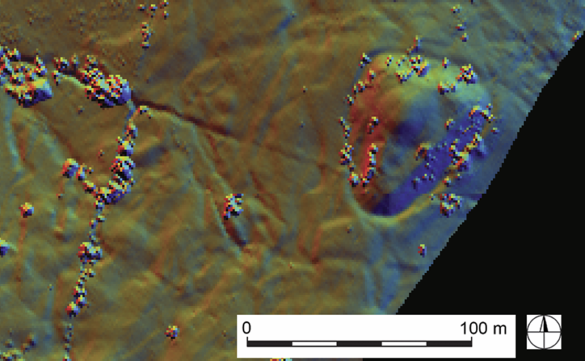
While we’re still awaiting the OSL dates that will allow us to phase the earthworks, our research has already made some key breakthroughs. It now appears that Saintbury’s lordly centre was developed on a pre-existing Roman site, perhaps a villa or even a military installation of some kind (Figure 2). In the early medieval period the earlier Roman complex was transformed, perhaps into an ecclesiastical community; several pre-Conquest charters relating to neighbouring estates mention ‘Cada’s Minster’ (cadan mynster) and, while the minster has previously been located at the nearby hillfort of Willsersey Camp, the earthworks adjacent to St Nicholas could well instead represent this early church. St Nicholas itself was constructed c.1100, at a time when the aristocracy were again investing heavily in Saintbury’s landscape. The appropriation of minsters for elites for their private use was increasingly common from the mid-ninth century, and at Saintbury we may be seeing an archaeological example of this process of secularisation. Not only is the residence adjacent to the church at Saintbury likely to have been enhanced, a previously little-recognised motte and bailey castle was also constructed around the same time 1km to the south-west (Figure 3). Whether the result of a divided manor, or an additional military installation to an existing lordly centre, the castle was certainly thoughtfully located; not only near to where the Roman Ryknild Street drops down the Cotswold scarp, but in close proximity to an early medieval assembly place called the Kiftsgate Stone (Figure 4). Our Saintbury case study is just one of several that the project has undertaken that not only neatly encapsulates the complexities of evolving aristocratic activity in the period, but also shows the value of concerted study of specific sites and landscapes.
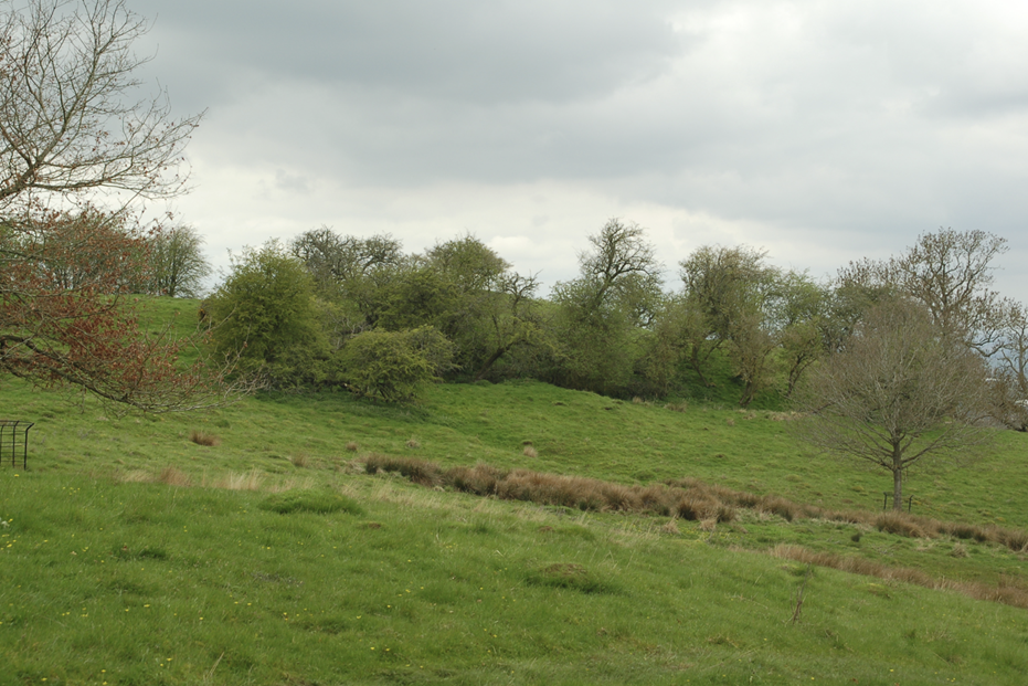
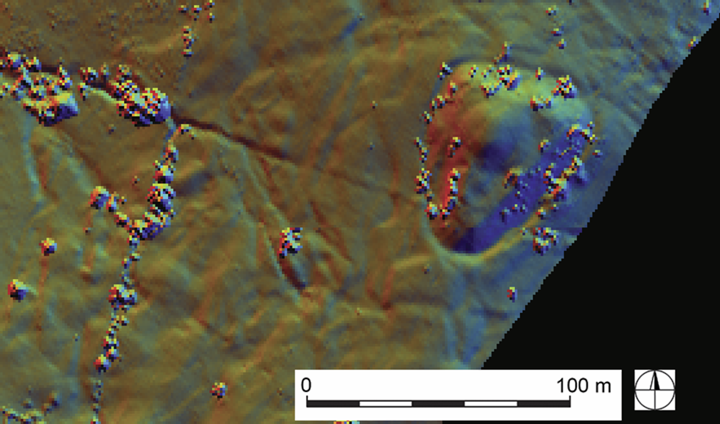
Figure 3: The tree-covered earthwork of the motte and bailey castle at Weston Park, Saintbury. The reuse of the monument in the post-medieval period as a prospect mound may partly explain why the castle has been overlooked by previous scholarship. Copyright Where Power Lies
Figure 4: LiDAR data of the motte and bailey at Weston Park, Saintbury. The monument has been sculpted to form a prospect mound for the nearby house, but was clearly originally a castle of the eleventh or twelfth century. 

Moving into its final few months, Where Power Lies is now integrating the findings from these different scales of work into a number of different outputs. The success of the project is partly down to the support of the Castle Studies Trust who generously funded three stages of a pilot scheme at Laughton en le Morthen, South Yorkshire, the results of which were recently published in Landscapes. The monies provided by the Castle Studies Trust were critical in allowing us to demonstrate the methods and concept behind Where Power Lies, resulting in an AHRC (Arts and Humanities Research Council) research grant for our 18-month long project. The project team hope that we can in some way repay this generosity, by placing early castles into a more coherent, longer-term picture of aristocratic development in the landscape of England.
Subscribe to our quarterly newsletter

Transforming our understanding of Shrewsbury Castle

With the excavation report on the third and final season of excavation which the CST has funded now published on our website, project lead Dr Nigel Baker looks at what has been achieved since the first work in 2019 to now.

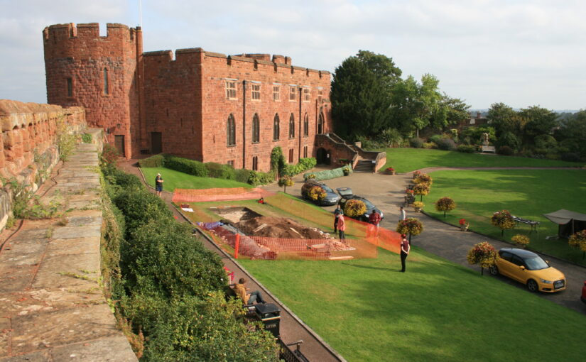
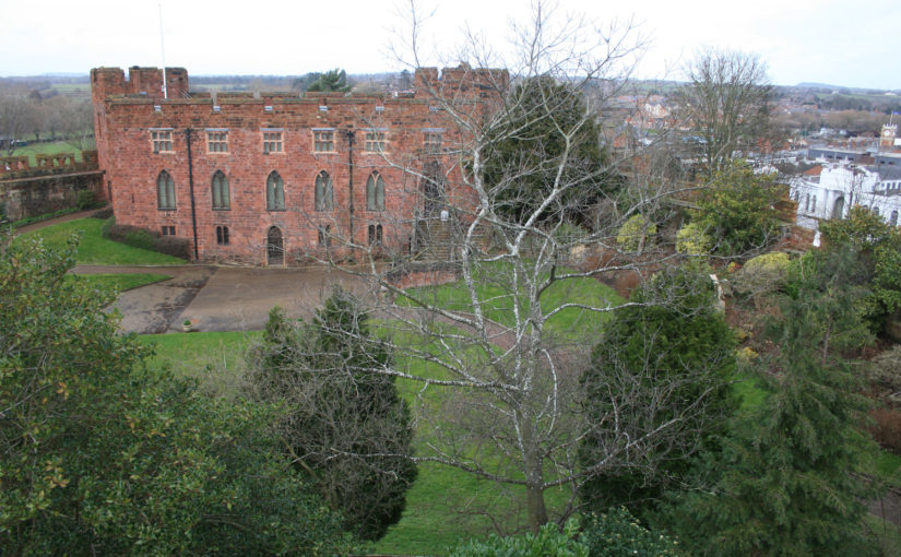
Just over a century ago Shrewsbury Castle began a new phase in its long life. In 1925 its principal surviving building, having been in use as a private dwelling since the castle was finally de-munitioned in 1686, became the meeting hall of Shrewsbury Borough Council, set in extensive landscaped gardens covering the remains of the motte and inner bailey, the outer bailey having (mostly) disappeared beneath the growing town by c.1300. Shrewsbury Castle remained more or less untouched by archaeology for the remainder of the 20th century. This changed in 2019 with the award by the Castle Studies Trust of a grant for a season of geophysical survey and excavation in the inner bailey. Following permission from Shropshire Council, the site owners, and Historic England, its legal guardians, the work took place in May and July 2019, the geophysics by contractors Tiger Geo and the excavation team made up of experienced local volunteers and staff and students of University Centre Shrewsbury. The results were unexpected.

Subscribe to our quarterly newsletter

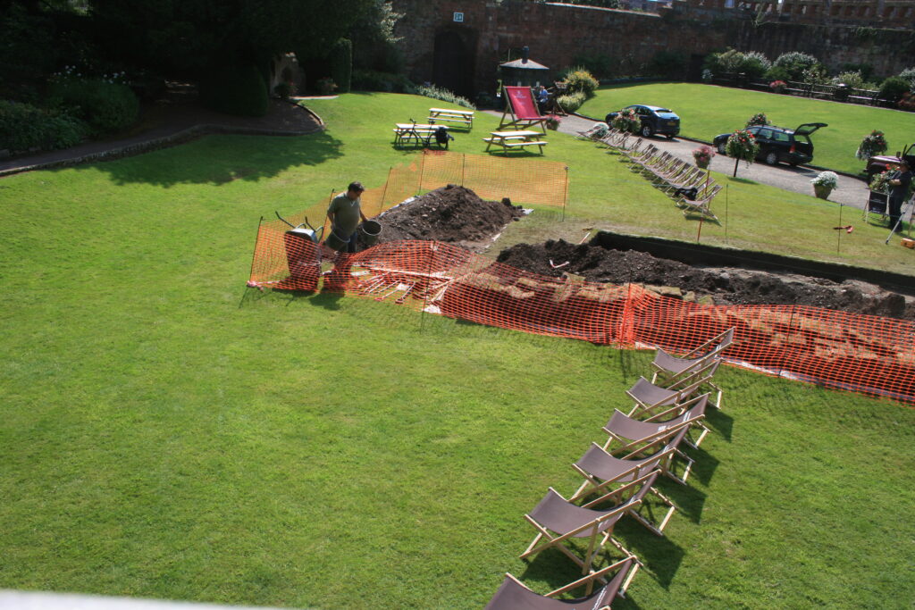
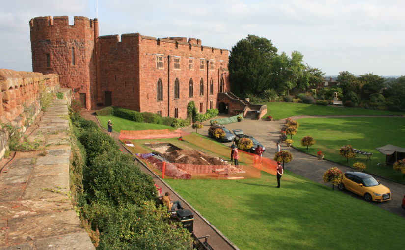
Shrewsbury Castle Excavation 2019 showing the width of the ditch around the motte using deckchairs (copyright Dr Nigel Baker)
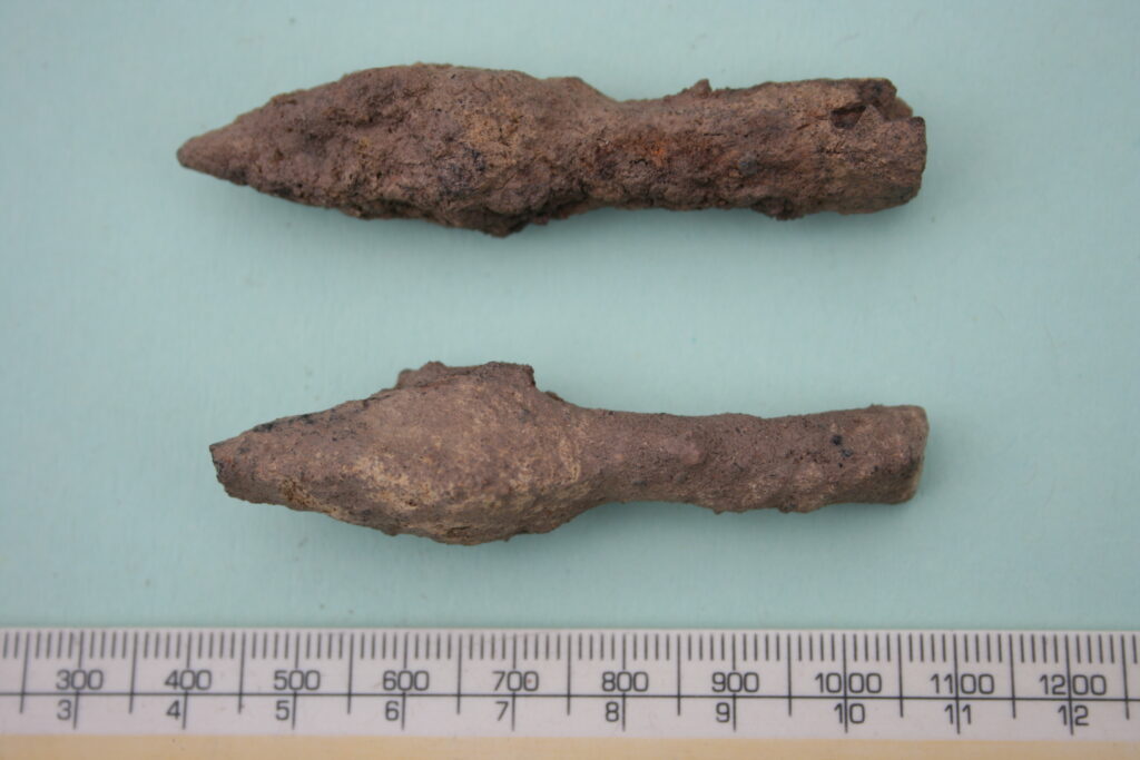
Arrow heads found in Shrewsbury Castle Motte Ditch (copyright Dr Nigel Baker)

Immediately under the turf was natural glacial gravel: the top of the hill on which the castle had been built; the ground surface had been lowered sometime in the past, removing nearly all archaeological remains. This was almost certainly the work of the young Thomas Telford who, from 1786 to 1790, lived in and ‘restored’ the castle for its owner, Sir William Pulteney, M.P. for Shrewsbury. However, archaeological strata were found to have survived within cuts into the natural gravel, and two of these were of major significance. The first was the edge of a previously-unknown ditch around the base of the motte. Medieval cooking-pot sherds of late 11th-13th-century date were found in its lowest excavated layers, along with two armour-piercing crossbow quarrel heads. The second significant find was of a pit containing in its fill a piece of decorated bone and two types of pre-Conquest (Saxon) pottery: Stafford-type ware, distributed widely across the emerging towns of the region and already well represented in Shrewsbury; and a limestone-tempered fabric, TF41a, never before seen in Shrewsbury, which had been made in the Gloucester area and probably imported up the Severn. This confirms that there was pre-Conquest activity on the site of the castle, and, along with the Domesday evidence that there was a church of St Michael there by 1086, may point in the direction of a high-status pre-Norman presence on this tactically-significant site controlling access to the ancient borough.

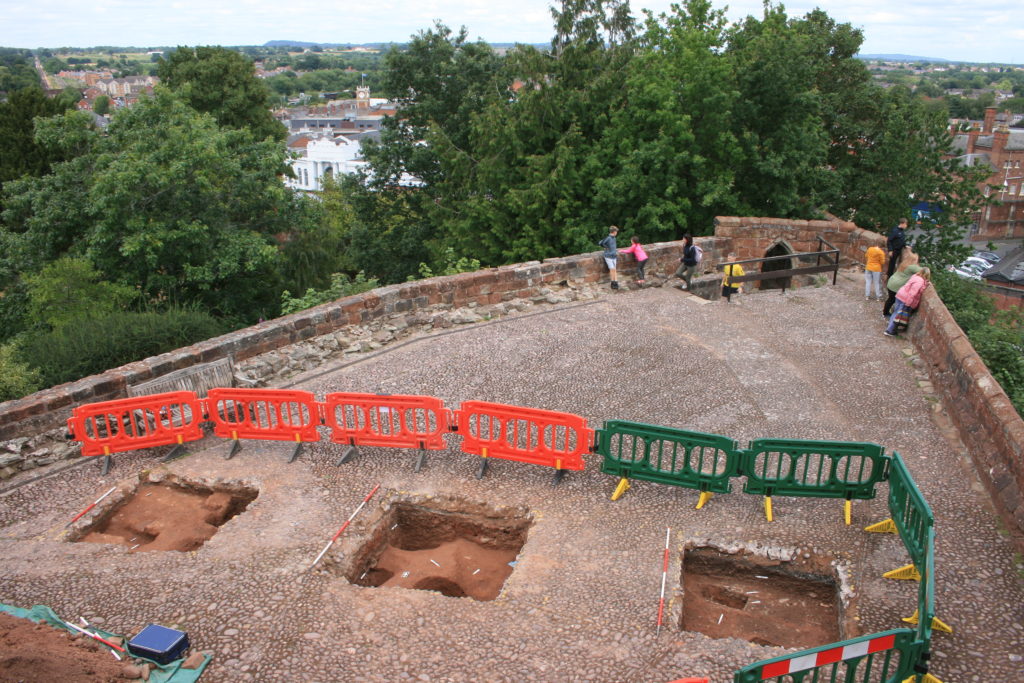
Shrewsbury Castle Excavation 2020 (copyright Dr Nigel Baker)

Excavation resumed in the autumn of 2020 with a trench seeking a sample profile through the west rampart of the inner bailey. This turned out not to be medieval in date. Both the west and the north rampart were probably created as part of Thomas Telford’s landscaping work in 1786-90. But, intriguingly, below the west rampart there was no sign within the trench of the natural hilltop gravel found close by in 2019 at a depth of just a few centimetres. The explanation may be that the bailey was enlarged westwards between the Norman period and the later medieval period, by dumping soil and levelling-up behind a new curtain wall.

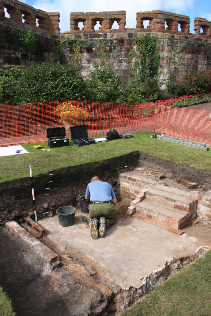
Shrewsbury Castle Excavation 2022 on the motte top (copyright Dr Nigel Baker

The final season of excavations took place in 2022 on the top of the motte, and outside the north curtain wall. Telford is known to have demolished ruined medieval buildings on the top of the motte and replaced them with the surviving two-storey Gothic summerhouse there. Excavation showed that Telford’s activities had, again, removed most of the archaeology but that the foundations of early medieval timber buildings (beam slots, a post pad, post holes) survived where they had been cut into the motte material. No definite trace was seen of the ‘great wooden tower’ which is documented on the motte top until its collapse in 1269-71.

New light was also shed on the motte by vegetation clearance on its south side, revealing for the first time remains of buildings incorporated in the masonry of the retaining walls. This work was undertaken on behalf of Shropshire Council for a new conservation-management plan, currently at consultation stage, which includes photogrammetric surveying of all the castle structures. This permanent stone-by-stone record not only forms the basis for the next vital stage of work – identifying and specifying long-needed repairs – it also offers new archaeological insights, including the identification of the probable primary sandstone rubble fabric of the curtain walls. This was in turn followed by some research carried out by Jason Hurst on Civil War musketry damage in 2023 (Potential shot damage at Shrewsbury Castle – Castle Studies Trust Blog) . And now, the process of publishing this body of new archaeological, architectural and historical information is just beginning…

Subscribe to our quarterly newsletter

From Edwin’s hall to Roger’s castle: the elite residence of Laughton en le Morthen, South Yorkshire

Since 2018 the Castle Studies Trust has funded archaeological investigation of the motte and bailey castle at Laughton en le Morthen, South Yorkshire. Led by Dr Duncan Wright of Newcastle University, a scheme of topographic and geophysical survey, followed by targeted excavation, showed that the castle at Laughton had been built on an earlier elite residence—almost certainly the hall complex of Earl Edwin of Mercia referred to in Domesday Book. The results of the fieldwork therefore show us how an existing high-status centre was transformed into a castle in the wake of the Norman Conquest. Using a combination of the evidence gathered in the field, and comparison with similar centres in the country, researchers are able to reconstruct the chronological development of tenth and eleventh-century Laughton with some confidence.

Subscribe to our quarterly newsletter

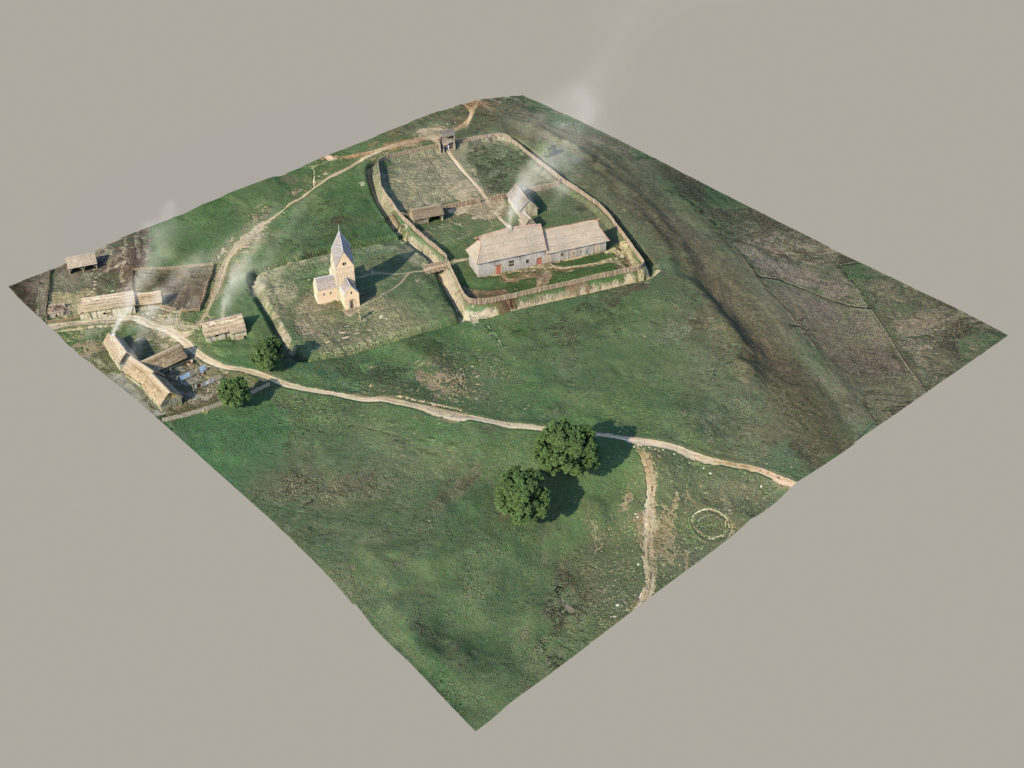
Laughton-en-le-Morthern as it might have been pre-Conquest (copyright Pighill Illtustrations)

The first reconstruction shows how the elite residence would have looked in the late tenth and first half of the eleventh century. The hall forms the focus of the complex, and this wooden building and any additional structures would have been surrounded by a ditched and fenced enclosure. The protective circuit was found during excavation, and it was even possible to see where wooden posts had been levered out of the ditch when it went out of use. Appended to the hall complex within its own enclosure would have been a stone-built church, a doorway from which survives in the north wall of the present building. Dr Michael Shapland suggests that the first church at Laughton may have been a free-standing ‘tower nave’ construction, for the exclusive use of the aristocracy rather than the wider community. To the east of the hall and church extended settlement and industrial activity, which has been found by previous archaeological investigation. Laughton would have been an important estate centre as well as an elite residence, and was a place where agricultural produce was collected and processed.

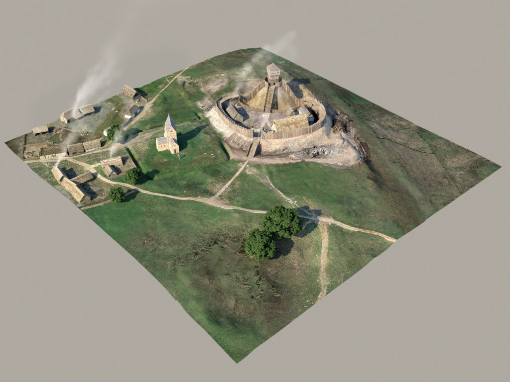
Laughton-en-le-Morthern as it might have been post Conquest (copyright Pighill Illustrations)

The second reconstruction depicts Laughton following the Conquest and after construction of the motte and bailey castle on the site of Earl Edwin’s hall. We cannot be sure when the castle was built, but it was most likely completed before the end of the eleventh century when Norman power in northern England was gradually being established. Laughton at this time was a contrasting picture of change and continuity, with some earlier parts of the elite complex maintained and others adapted or removed. Most obviously, the residential parts of the site were destroyed to construct the castle; excavation showed how the ditches surrounding Edwin’s hall were quickly infilled, and the posts supporting the fence were removed. Geophysics also confirms that the 9m-high motte at Laughton was built direct over the middle of the earlier arrangement, and extended over the western part of the enclosure. The church probably kept its original form in the eleventh century, and was only updated in the twelfth century after it came under the control of York Minster. While investment in the church continued through the twelfth century and later, occupation of the castle seems to have been very short-lived. Excavation identified no material from the later medieval period, and the motte and bailey was not enhanced with stone structures. At Laughton it seems that building of the castle was more important than its actual occupation; construction involved the destruction of Edwin’s residence and the raising of something new that demonstrated the establishment of Norman authority. Nearby Tickhill instead emerged as the most important secular centre in the region.  

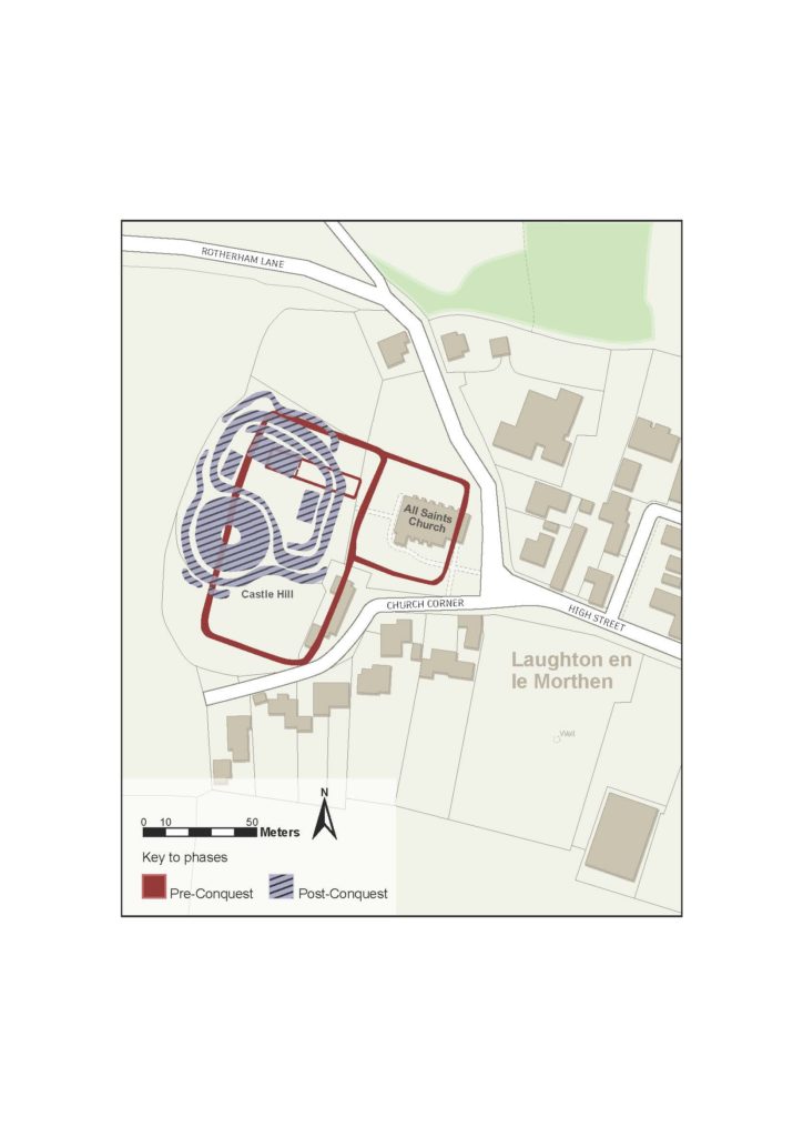
Phased Plan of Laughton en le Morthern

The phase plan outlines the core components of the two chronological periods recognised at Laughton. It makes clear how construction of the castle destroyed and disrupted the earlier elements of the high-status complex.

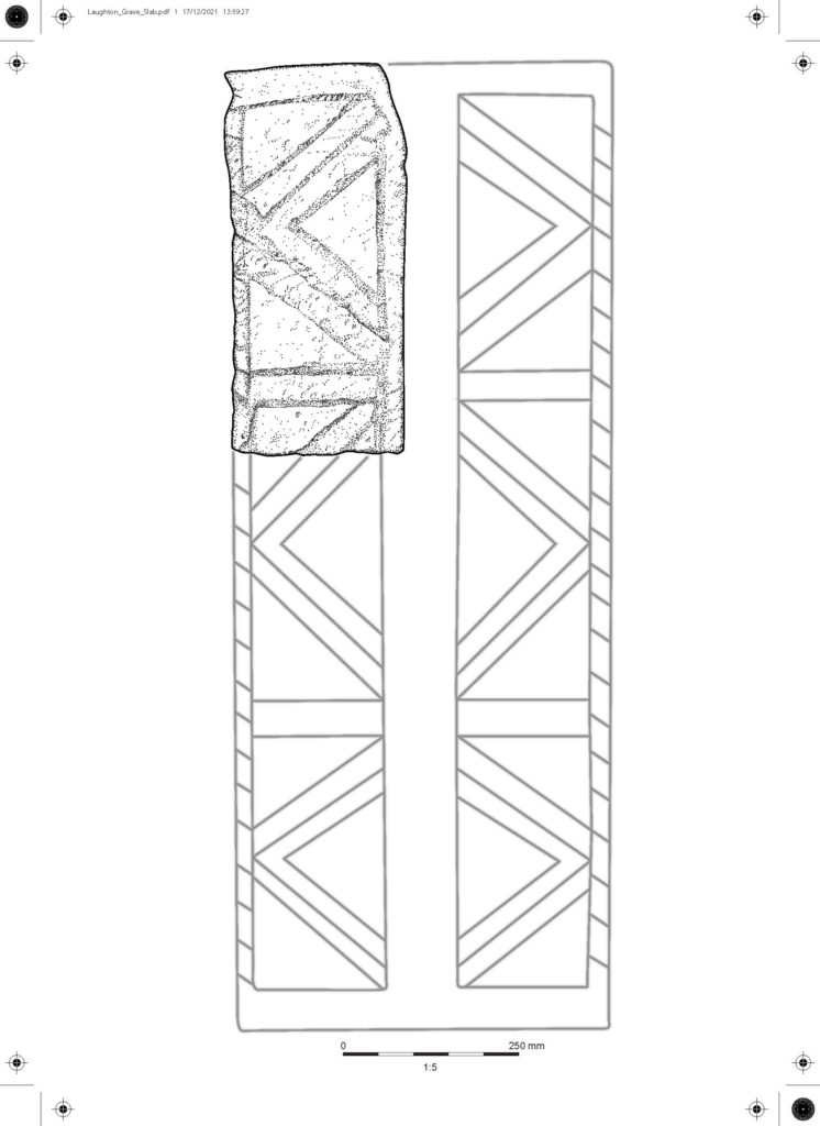
Early grave cover

The stone illustration represents about one sixth of an early grave cover with incised decoration, which was analysed by Professor David Stocker and Dr Paul Everson. This type of monument is well-recognised in eastern England and Yorkshire, and at Laughton the stone can be found built into the eastern wall of the chancel. It is a difficult stone to date precisely, but probably dates to the eleventh century and would originally have covered a burial either within or outside of the church.

Subscribe to our quarterly newsletter

All pictures and illustrations ndertaken by Peter and Rosalyn Lorimer of Pighill Archaeological Illustration. 

Where Power Lies: the archaeology of transforming elite centres in the landscape of medieval England c. AD 800-1200

Between 2018-2021, the Castle Studies Trust awarded Dr Duncan Wright three small grants to research the castle of Laughton-en-le-Morthen. The aim was to develop an innovative new research methodology to understand the near wholesale replacement of existing lords with incoming Norman tenants-in-chief physically showed itself post the Norman Conquest. Here Duncan explains what that has helped lead to.

In October 2021 the Arts and Humanities Research Council (AHRC) awarded Dr Duncan Wright (Newcastle University) an Early Career Research Grant of £200,000 in support of a new archaeological research project.

Subscribe to our quarterly newsletter

Entitled ‘Where Power Lies’, the project will undertake the first systematic examination of the physical evidence for elite centres in the landscape of medieval England between c. 800-1200AD. Many of these high-status places were developed as castles, and the research aims to identify the motivations behind choosing to build a castle at an existing lordly centre, when a site could equally be perpetuated as a manor house or else abandoned altogether.

The success of Duncan’s AHRC bid is partly thanks to the support of the Castle Studies Trust, who funded his research at Laughton en le Morthen (South Yorkshire) with three separate grant awards totalling almost £5000. The work at Laughton, which comprised geophysical and topographic survey, targeted excavation, and the commission of 3D reconstructions, not only helped reveal the complex history of the site but also acted as an important pilot and proof of concept for the new project. Indeed, Where Power Lies hopes to emulate the success of the research at Laughton, and will include some of the same survey techniques, but it will also scale up the focus to look at the national distribution of aristocratic centres with evidence for investment in both church and residential components.

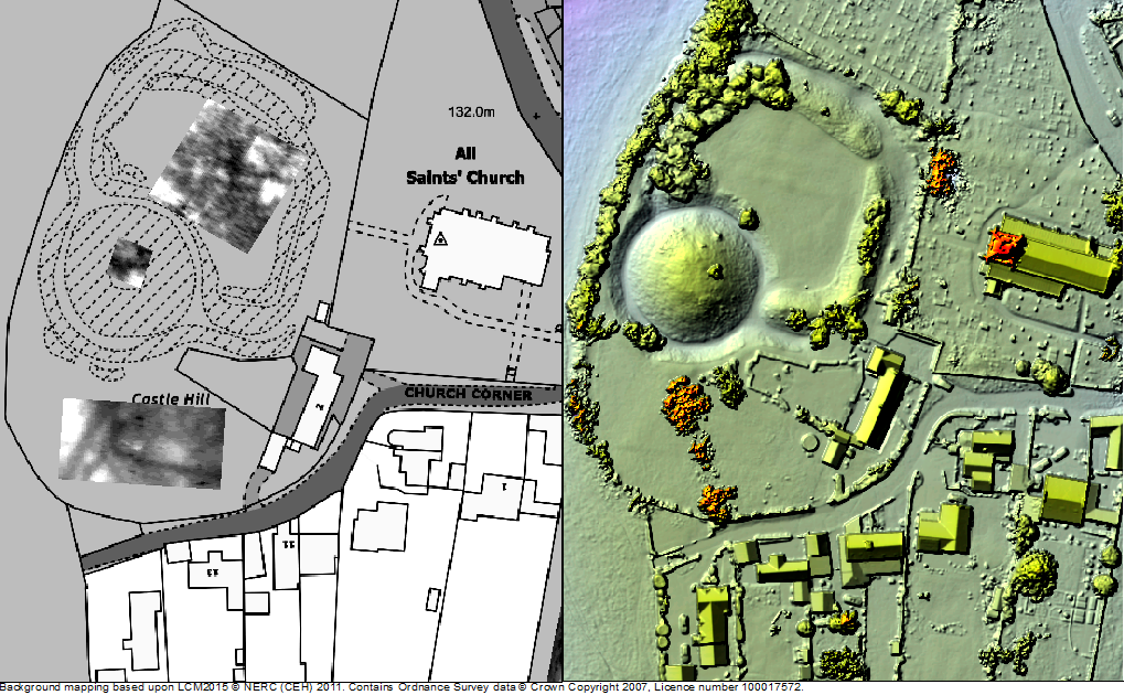
Survey results of geophysical survey of Laughton-en-le-Morthen

After modelling the national picture, the Where Power Lies team will investigate a carefully selected sample of case study sites, which will be subject to topographic, geophysical, and standing building surveys. These investigations will allow us to reconstruct the biography of the case study locations in detail, and to explore how the character and expression of elite power invested in their residential and ecclesiastical complexes evolved over time. Working with the British Museum’s Portable Antiquities Scheme as an official project partner, the research will also produce a new profile of the artefacts of the aristocrats who built and occupied these sites. 

By undertaking this work, Where Power lies will shift the focus beyond the relatively small corpus of excavated aristocratic sites of the period which continue to form the basis of our understanding. Instead, by embracing a range of digital technologies and non-intrusive survey methods, the projectwill create valuable new datasets at a number of scales. By generating this new information, the team will demonstrate how the transformation of power centres occurred on the ground, revealing whether castles integrated earlier components into remodelled layouts, or whether they caused greater destruction and a more fundamental schism with the past.

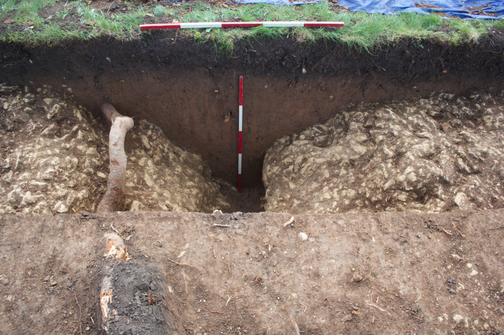
Excavation at Laughton showing remains of a ditch that ran next to a possible entrance way to the Saxon lordly centre.

The team will be led by Duncan as Principal Investigator, who will be accompanied by Professor Oliver Creighton (Exeter University) as Co-Investigator, and a Research Associate who will join the team for the duration of the project. Duncan would like to take this opportunity to thank the Castle Studies Trust for their generous support of his research at Laughton en le Morthen, which strengthened the AHRC bid significantly. He hopes the results of Where Power Lies will prove of interest to everyone associated with the Trust.

Subscribe to our quarterly newsletter

You can read more about the Laughton-en-le-Morthen project here: https://castlestudiestrust.org/blog/2020/08/25/landscapes-of-lordship-searching-for-laughtons-anglo-saxon-elite/

Recent discoveries at Shrewsbury Castle

With the 2020 excavation report now published, Shrewsbury Castle Excavation Director Dr Nigel Baker looks back at the two years of excavations and what they reveal about this important castle of the Welsh Marches.

Before the excavations in 2019 and 2020 funded by the Castle Studies Trust, Shrewsbury Castle was one of the least well understood major castles of the Welsh Marches. Its visible form is that of a classic motte-and-bailey, with earthen ramparts surmounted by stone curtain walls. However, the archaeological project and associated research has shown that the historical reality is more complex than this.

Subscribe to our quarterly newsletter

First recorded as a consequence of being besieged by local rebels in 1069, many aspects of its recorded history follow a familiar Marches pattern: heavy royal expenditure in the 12th and 13th centuries as a campaign base and in the face of Welsh raiding, followed by decline into obsolescence and ruination in the 14th, 15th and 16th centuries, arrested temporarily by a return to active service in the English Civil War in the 1640s. Its later history was as a private residence, distinguished by its ‘restoration’ by Thomas Telford in 1786-1790, and finally its return to public life as a council meeting hall in 1925 and as the home of a regimental museum in the 1980s.

First of all, the Norman castle was not built on an empty site. It occupied the end of a ridge that was critical to the defence of the old Saxon borough, and the 2019 excavation demonstrated occupation here in the 10th or early 11th century, on a plateau or low knoll at about 68m AOD, higher than its surroundings, and at one end of the likely cross-peninsula borough defences. At present the archaeological evidence is limited to a single pit and its artefacts, but reading between the lines of the historical record, it is possible that the site was shared by a church dedicated to St Michael and perhaps a hall, maybe that of the pre-Conquest sheriffs.

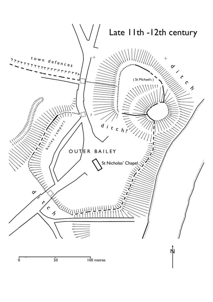
Plan of Shewsbury Castle as it may have appeared in late 11th / early 12th century copyright Dr Nigel Baker. The black lines indicates probable masonry curtain wall lines, based on the presence of the ‘green slabby rubble’ masonry that appears at various junctures at the bottom of some elevations and seems to be early, meaning potentially pre-13th

The Norman castle of the 1060s wiped out all that had been there before, except the church, which appears in Domesday Book; this also records the loss of 51 tax-paying households when the castle was built. It consisted of a large motte overlooking the river, elevated to a height (80m AOD) equal to that of the royal and episcopal halls within the old borough, with a substantial ditch, discovered in 2019, around its base. West of the motte was a small inner bailey. Extending south was a much larger outer bailey, separated from the English borough further south by a second cross-peninsula ditch and supplemented in the 12th century by earth ramparts around the bailey perimeter. The small size of the inner bailey, in reality perhaps more of a barbican, suggests that the royal hall, documented from 1246 but probably present from the beginning, was on the motte top.

It is not yet clear when the earth and timber defences began to be replaced in stone, but stretches of thin, slabby rubble in the curtain walls and motte wing walls may be indicative of work in the late 12th or early 13th century.

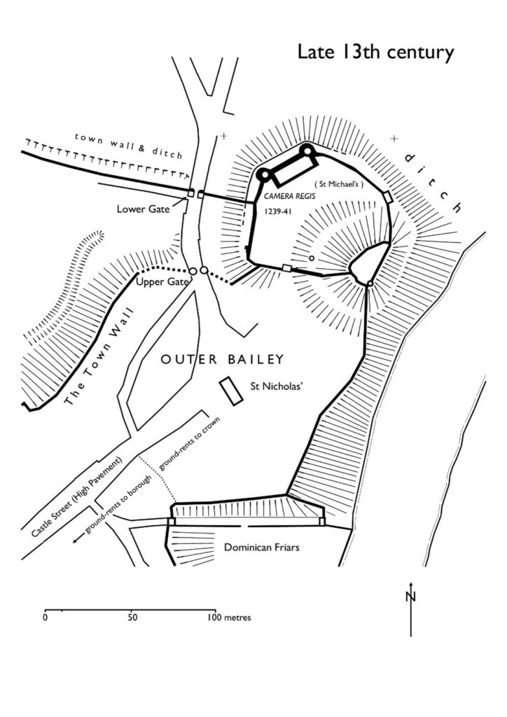
Major changes took place throughout the 13th century, some documented, some suggested by the excavations. The single surviving medieval building, often called the hall, is fairly certainly the camera regis or royal chamber built in 1239-41, a date consistent with the dendrochronological evidence from the building. It may have been constructed as part of a larger rebuilding campaign that saw the west side of the inner bailey expanded westwards by pushing a terrace out over the gradient behind a newly-built ashlar curtain wall. This is one of the conclusions of the 2020 excavation trench through the western rampart, which found medieval tipped strata at a level below that of the natural gravel seen in the interior of the bailey in 2019.

Plan of Shrewsbury Castle in late C13. Copyright Dr Nigel Baker

Meanwhile, the east side of the motte was subject to erosion by the River Severn and the consequent partial collapse of the motte was recorded by an enquiry held in 1255; in 1269-71 a ‘great wooden tower’ fell down and was said to be totally destroyed. The motte top was repaired towards the end of the 13th century with a new wall built across the damaged side in red and white striped masonry. The motte ditch appears to have been infilled, mainly by the deposition of rubbish, and a new castle well, which survives, was dug within it.

As the town grew, the outer bailey was built over. In 1220-c.1250 when the town walls were built, the outer bailey was walled continuously with the rest of the town and no longer separated from it; the tenements that had been established there continued to pay their ground rents to the crown while those outside, further south, paid theirs to the borough.

Two early plans show what had become of the castle by the end of the 16th century. The Burghley Map of Shrewsbury of c.1575 shows the main building unroofed, a smaller building (perhaps St Michael’s) in ruins, and just one roofed building standing in the inner bailey in the area of the surviving well. A sketch plan by the master mason John Smythson of 1627 likewise shows the main building, and most of the curtain walls, in a ruined condition; it also shows a gatehouse of which there is no other evidence.

Restoration came in 1643-44 when the castle was garrisoned by the Royalists, and the borough’s mayoral accounts record expenditure on the main gate and its new barbican, a new postern gate, walls and outworks. The castle was captured for Parliament in February 1645; what appears to be battle-damage can be seen on the woodwork of the main gate and around the openings of the main building but this identification now needs confirmation by battlefield archaeologists. After its capture, the Parliamentarians continued the Royalists’ restoration of the main building, its roof and gallery built with timber felled in the winter of 1647. The castle was finally de-munitioned in 1686 and became a private residence.

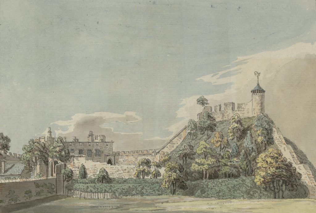
Shrewsbury Castle in 18th Century, note on the wall on top of the motte the possible base of windows of a high status building / Great Hall.

Thomas Telford’s ‘restoration’ of the castle in 1786-1790 for Sir William Pulteney was nothing if not brutal. The excavations in the inner bailey have shown that the interior was levelled down, scraped bare, and at least some of the material used to enhance or even create the ‘ramparts’ around the perimeter. Illustrations show that, until 1786, the motte top was still occupied by a 13th-century round tower and the ruins of other, as yet unidentified, buildings. These were all swept away and replaced by Telford’s ‘Laura’s Tower’, a fine, two-storey summerhouse in the Gothick style.

Subscribe to our quarterly newsletter

What lies beneath: what a ground penetrating radar survey reveals of Druminnor Castle

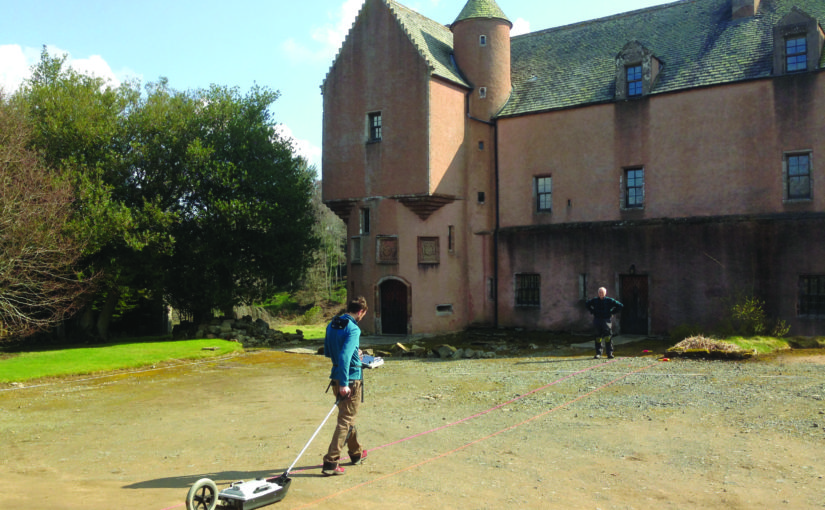
Lead Archaeologist on the Druminnor Castle excavation, Dr Colin Shepherd, looks at the results of the ground penetrating radar (GPR) survey of the castle in funded by the Castle Studies Trust in 2019 and what that means for future work at the site.

As a consequence of the GPR geophysics, that were generously funded by the Castle Studies Trust, we have a number of new and potentially interesting anomalies to be investigated. Furthermore, the GPR research has also been instrumental in clarifying other aspects of previously excavated evidence. This has been made possible as, contrary to most instances, the geophysics at Druminnor have been incorporated into the ongoing investigation rather than simply as a precursor to excavation.

Subscribe to our quarterly newsletter

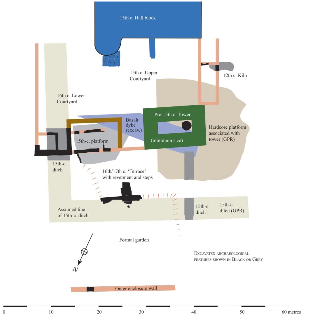
The GPR generated 286 ‘radargrams’ or sections across the site and much time and effort has gone into analyzing these. The radargrams were compared to actual excavated sections. This permitted the creation of a ‘key’ that has allowed us to extrapolate from the excavated sections to unexcavated parts of the site. As a result, we can, fairly comfortably, suggest a developmental plan of Druminnor spanning the 13th to 18th centuries (Figure 1).

Suggested phasing of Druminnor Castle by Colin Shepherd

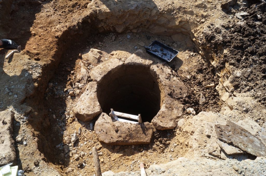
The GPR has suggested the extent of a hardcore platform that appears to have supported the ‘Old Tower’. This was thought to have been the earliest part of the castle but without hard evidence. We hope to test the presumed limit of this platform as we extend our trench southwards from the well that sat within the tower. (As you will recall, the GPR alerted us to that remarkable feature that became a focus for our 2019 season.) The GPR suggests that there may be a revetment supporting the platform at that point. Also, any relationship between this platform and the mid 12th-century kiln will be important in attempting to date that platform and, by extension, the Old Tower itself.

Well found in tower as a result of the GPR survey

The radargrams have also demonstrated the probable line of a terrace and sunken formal garden (red hachures on plan) and permits the excavated section of revetment and steps (shown in black) to be placed in its proper context. This garden probably dates to the 16th or 17th century, though exactly when is still debatable. The construction of the terrace removed all trace of the earlier (early to mid 15th century) ditch and so must post-date that. A late 17th-century Dutch pipe bowl found in the fill of a post hole associated with the steps suggests its removal at around that time or shortly thereafter. No trace of the terrace appears on the estate plans of c.1770.

The line of the defensive ditch has been shown by the radargrams to extend westwards from the excavated portion in Trench 11. This gives us an accurate alignment permitting its course to be drawn, even though the middle section was removed by the terrace. Where its return is at the western end of the site is still a mystery. The eastern arm was excavated in Trench 2 lying beneath the later (early 16th-century) lower courtyard. The 15th-century upper courtyard incorporated the tower with the surviving hall block (shown in blue). The courtyard’s west range can be estimated from remains found during the kiln excavation, but its eastern boundary was removed when the lower courtyard was added.

Finally, the GPR revealed the line of the outer enclosure wall as depicted on the estate plans. This was sampled in 2019 and the base of the wall found. The date of this feature is presently unknown and further work needs to be done to try to clarify that matter.

Evidence of landscaping material in outer enclosure copyright Iain Ralston

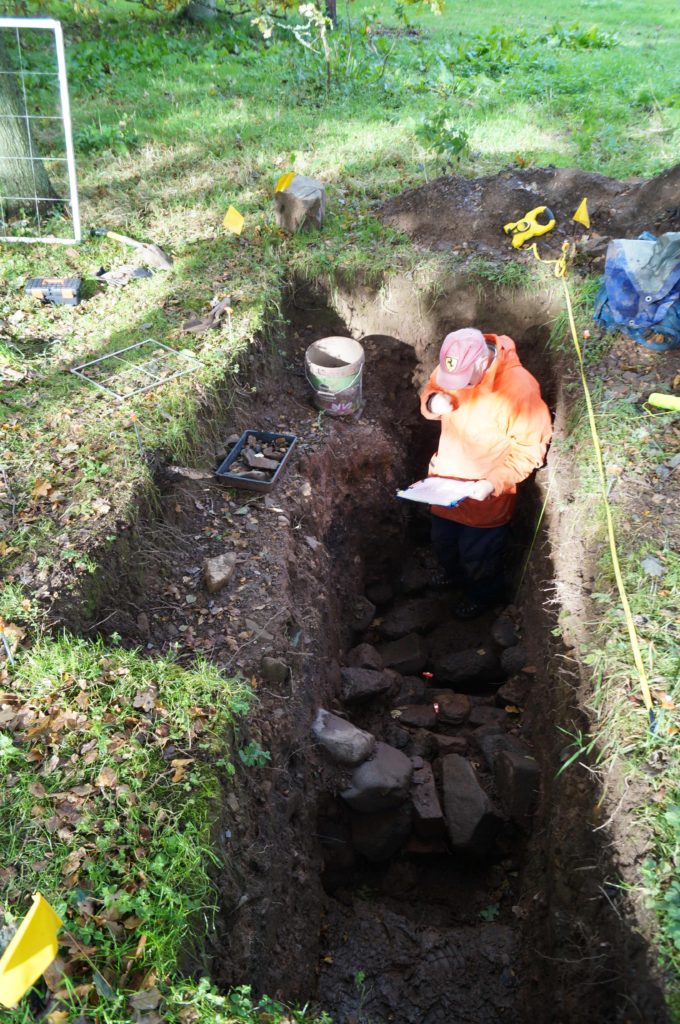
Sadly, work planned for 2020 included the extension of the ‘well trench’ in the car park to look for the possible revetment suggested by the GPR as well as opening a much bigger area across the outer enclosure wall, as located by GPR. This sits beneath a good metre and a half of later landscaping material (see picture, courtesy of Iain Ralston) and, for safety and archaeological reasons, demands a much larger trench. The keyhole sample trench indicates good survival and, it is hoped, evidence will be found to date the feature and to help explain when this became the northern boundary of the castle enclosure.

The excavated evidence together with the GPR results permit this developmental plan to be made and rough dates affixed. It is worth noting that, prior to our investigations, Druminnor was believed to have consisted solely of the surviving hall block with an attached tower at its western end. Everything not in blue on the plan, therefore, was formerly completely unknown.

Access in 2021 is still, sadly, in the laps of the Gods owing to Covid, but it is hoped that we will be able to get back on track later this year to look for more goodies!

Subscribe to our quarterly newsletter

Unravelling the past of Hoghton Tower

Steven Spencer and Elena Faraoni of the Hoghton Tower Preservation Trust, look at the results of their work, funded by the Castle Studies Trust in 2019, in trying to find out more about Hoghton Tower in Lancashire.

Hoghton Tower sits 650 ft above sea-level in the heart of the Lancashire countryside. The stories of its visitors and family members are documented and shared whether it be in books, portraits, family albums or documents in the Lancashire archives. But there is one story which has always intrigued us and that is: what was the first tower of Hoghton Tower and where was it? It is clear when looking at the building today that this, like many other historic houses, is a ‘patchwork’ of different projects by different generations interlaced and blended…but where did Hoghton Tower start? Where was the original tower?

Subscribe to our quarterly newsletter

 There are some clues: the ageing of the stone, the position of the well house, family stories passed down the generations, the shape of the windows and a mysterious mound of stones on the north side of the buildings. One of these stones has an intriguing mason’s mark… Spurred on by the interest of a group of our amazing volunteers who had just finished some research into historic graffiti and masons’ marks it was time to do some investigation under the guidance of Dr Mike Nevell and his team at Salford University. We designed a research project based on archaeological digs, building recording, geophysics and archives research based on the key exam question “where was the great keep of the Hoghton Tower hill?”

North side of Hoghton Tower (copyright Hoghton Preservation Trust)

 Thanks to the grant from the Castle Studies Trust, work quickly got underway. Through a series of Salford-led workshops, the team surveyed, recorded and reviewed old photographs and pictures.

Then there was the wonderful five-day archaeological dig.

As they passed through the perimeter fencing on to the dig site, the usually mild-mannered volunteers underwent personality transformations as pairs of friends and even married couples were ‘pitted’ against one another. Was this the site of a 14th century Pele Tower, a 1643 victim of the First Civil War, who would make the crucial find?

Under the patient guidance and control of the Salford team, the test pits were marked out and the excavations began, to many this was the chance of a lifetime and was eagerly embraced. Each find was announced with enthusiastic shouting from the discoverer and muted derision from those yet to make a meaningful contribution.

Hoghton Tower Gatehouse from inside the courtyard (copyright Hoghton Tower Preservation Trust)

As the week progressed, 14th to 19th century finds were unearthed, thankfully shared out between the eight test pits. Clay pipe bowls (1640 to 1680), a musket ball, heat affected glass, sherds of medieval pottery and fragments of medieval roof tiles. Below a stone rubble layer, evidence of a stone-built structure was revealed in the form of large dressed stone blocks, together with walls and a stone flagged floor.

Spurred on by the whole experience, and encouraged by the de Hoghton family, the volunteers have produced and presented an ‘Outdoor History’ tour which aims to share the latest thoughts and discoveries. 

Was this the site of the Hoghton Tower? Did we find anything categorical? Well yes and no. The archaeology revealed previously unrecorded stone structures. These together with the artefactual evidence were able to confirm that this part of the hilltop was occupied during the late medieval/early post-medieval periods. The geophysics also gave us other areas that warrant more digging and researching. So, some confirmation but also a lot more to understand and discover on this windswept hill!

Subscribe to our quarterly newsletter

Featured image of Hoghton Tower, copyright Hoghton Tower Preservation Trust

Landscapes of Lordship: Searching for Laughton’s Anglo Saxon elite

In an article that first appeared in Current Archaeology issue 360 (March 2020) Duncan Wright and Samuel Bromage discuss how the two research projects which they undertook at Laughton-en-le Morthen, with CST’s funds, has shown how the siting of castles was influenced by the older patterns of high-status activity in South Yorkshire.

Castles are perhaps the most iconic buildings of the medieval period, which for many are synonymous with feudal warfare and conflict. In spite of this popular perception, the idea that castles were mainly built for military purposes has been questioned for some time, and archaeologists now point to a number of reasons for their construction. In England, even fortifications thrown up in the wake of the Norman invasion are no longer seen purely as tools of martial conquest.

Subscribe to our quarterly newsletter

Instead, it is increasingly clear that earlier patterns of aristocratic life were important, and that the manorial residences of the Anglo-Saxon nobility in particular were chosen for the siting of early castles. Such targeting should not come as a surprise—the Conquest is understood as an exercise in elite regime change, which saw the near wholesale replacement of existing lords with incoming Norman tenants-in-chief. Yet, the way in which this transformation physically manifested is poorly understood. Few relevant sites have been subject to excavation, and where archaeological intervention has taken place it has often been piecemeal or of limited size. The Landscapes of Lordship project seeks to improve this picture, and recent work at Laughton-en-le-Morthen in South Yorkshire, funded by The Castle Studies Trust, offers a case study of archaeology’s potential to reveal more about this fundamental aspect of the Conquest.  

Anglo Saxon Elements

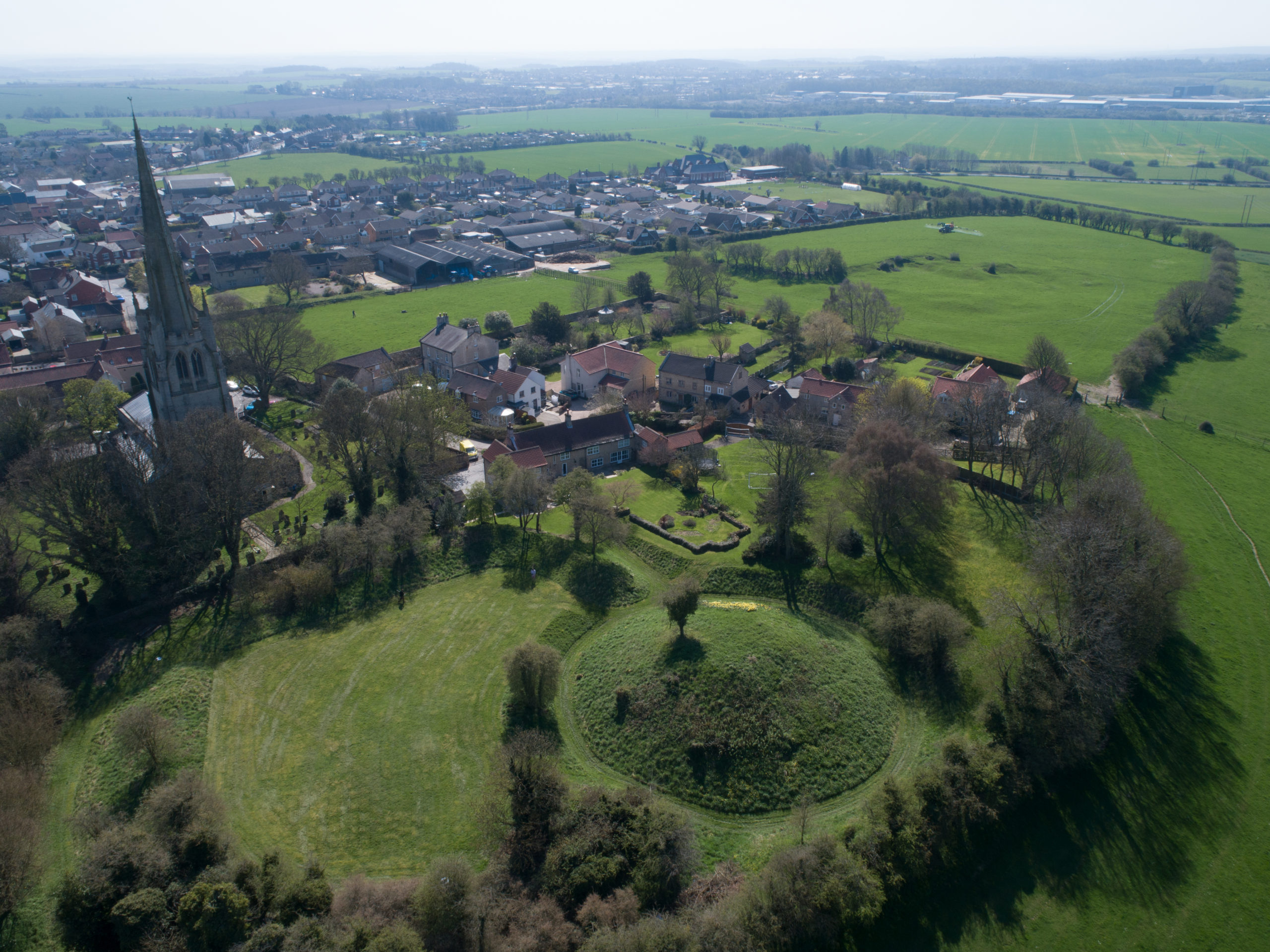
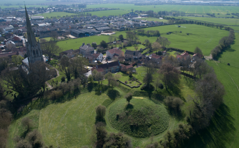
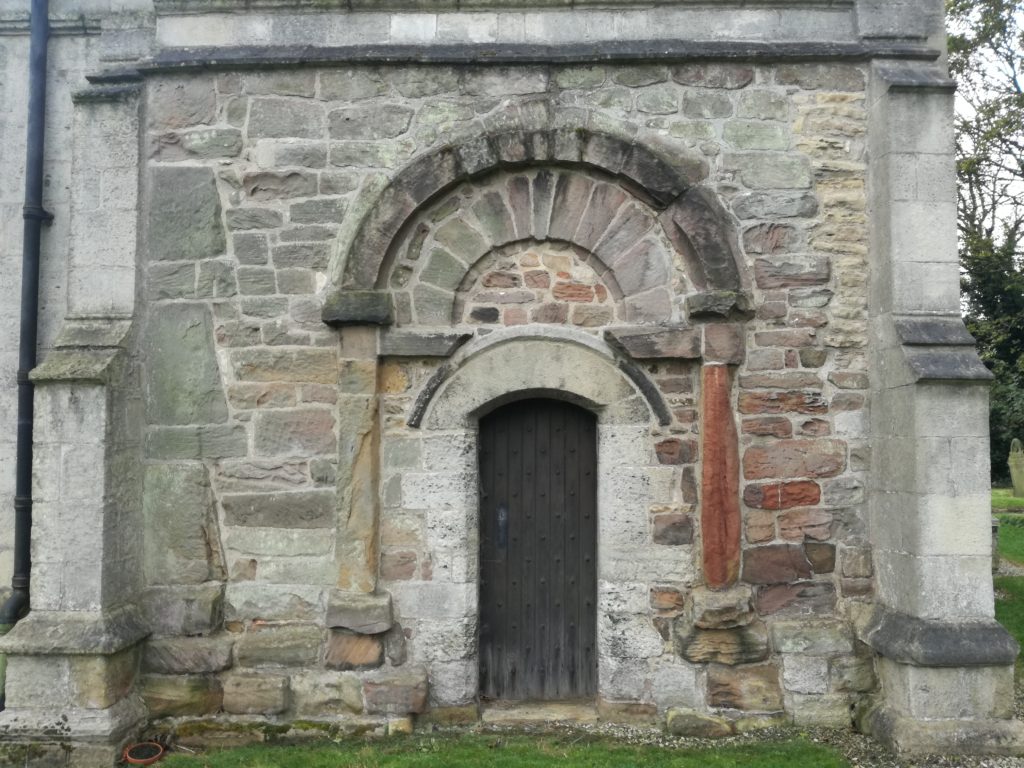
Laughton today is a modestly-sized village in the Rotherham district, perched high on a limestone ridge which offers impressive views, especially westwards towards the Peak District. The historic core of Laughton is focussed around the parish church of All Saints and the adjacent remains of a motte and bailey castle. A visit to the former provides the first hints of Laughton’s early history; an elaborate 10th or 11th-century doorway is located in the church’s north wall, and a similarly-dated grave slab is built into the eastern exterior of the chancel. Inside the church, a triangular-headed opening, a distinctive pre-Conquest form, covers a piscina—a shallow basin used to wash communion vessels. These pieces of stonework indicate the presence of an earlier building at Laughton, decorative fragments of which have been reused in later phases of construction. It is almost certain that this structure too was a church, as stone was almost never used for secular building in early medieval England.
Elaborate C10 or C11 doorway at the parish church.

In 2005 archaeological excavations due east of All Saints also found evidence of pre-Conquest activity, in the form of a circular grain-drying kiln. A significant assemblage of 10th—11th-century pottery was recovered from the excavations, highly unusual finds given that South Yorkshire was largely aceramic at this time. Documentary sources help to provide some context for the excavated material and that found in the church. The Domesday Book records that, prior to the Conquest, Earl Edwin of Mercia had an ‘aula’ or hall at Laughton. Edwin was a leading noble, but also a leading protagonist against the Norman regime. Brother-in-law of Harold Godwinson, Edwin, together with his younger brother Morcar, raised an unsuccessful rebellion against William the Conqueror after the Battle of Hastings. Dispossessed of his extensive lands, Edwin was ambushed and killed three years later.

Subscribe to our quarterly newsletter

Exactly where Earl Edwin’s hall was located in Laughton has long been a mystery, with the popular belief that it lies under the earthworks of the castle. The Landscapes of Lordship project set out to test this idea, firstly through a scheme of topographic and geophysical survey. A detailed topographic model of the castle and the surrounding parts of the village was made using a drone, and earth resistance survey provided a plan of buried features from the bailey and an area of open ground to the south. The results from the combined techniques exceeded even the expectations of the team, identifying a host of important archaeological features. In the bailey, geophysics picked up a number of anomalies which were also detectable as a low earthwork—the size and shape of which is consistent with buildings, and probably represent the centre of Earl Edwin’s hall complex. To the south of the bailey, ditches seemed to form two sides of an enclosure, one side of which was interrupted by the apparent construction of the motte. 

Survey results from the first year of research funded by the CST

Although the project team were confident that these features were related to Edwin’s estate centre, it was decided that a targeted excavation would be best to confirm this conclusion. A second phase of work, also supported by the Castle Studies Trust, was instigated to ground truth some of these findings, with two trial trenches dug over the ditches to the south of the castle. Excavations uncovered a V-profile ditch with a distinctive narrow base, which would have served to locate a wooden palisade, supporting the premise that this was indeed Edwin’s compound. No datable material was recovered from the ditch but the material inside was notably clean and consistent, indicating that infilling had occurred in a short window or perhaps as a single event. Beyond the enclosed area, another more substantial ditch was found—this feature seemed to project southward from the castle and may be part of an enclosure surround the village, the form of which is preserved in the historic street plan.

Hunting the Hall

The Landscape of Lordship investigations, then, support the idea that Laughton was indeed the site of Earl Edwin’s ‘aula’ and other buildings, which were surrounded on all sides by a ditched enclosure enhanced with a palisade. Edwin and his entourage would have had exclusive use of the elaborate stone church, which topographic evidence demonstrates lay within its own small rectilinear churchyard. Outside of this high-status enclave, the find of a drying kiln suggests that Laughton acted as a point for the collection and processing of agricultural produce, potentially from an extensive area. Indeed, Laughton was the centre of a large territory incorporating several later parishes, the component settlements of which are now most discernible by their ‘Morthen’ place-names.

Ditch found during the excavation

At some stage, Laughton’s lordly compound was radically transformed—the palisade fence was taken down and the ditches rapidly filled in; in their place was constructed a massive earthwork motte across the western edge of the enclosure. A kidney-shaped bailey incorporated the most important buildings including the hall, but it is impossible to tell without more investigation whether these were maintained or replaced with new structures. Probably around the same time the settlement to the east of castle and church was surrounded by a rectilinear enclosure, effectively forming an extensive outer bailey of the castle. Such arrangements are not uncommon in England but perhaps the most famous is at Pleshey in Essex, where a semi-circular bank and ditch encircles the village to the north of a motte and bailey castle.

While the nature of the archaeological evidence does not provide absolute dates, the most compelling context for the apparently rapid changes visible at Laughton is the protracted conquest and subduing of northern England in the years following the Norman invasion. Once annexed, Laughton and its estate were quickly subsumed into a large territory given to Roger de Busli who established a centre at Tickhill where a sizeable castle was erected. Given that the main seat of authority lay at Tickhill, it is unusual that Laughton too was furnished with a castle and that it continued to act as an administrative focus at least temporarily. The explanation for Laughton’s perpetuated importance undoubtedly lies in its pre-Conquest past. As an important residence of Earl Edwin, a foremost member of the Anglo-Saxon elite, Laughton’s appropriation was clearly an attempt to assume a recognised place of power. Yet, the drastic overhaul of the site also embodies a conspicuous act of conquest, physically destroying the complex of a central opponent to Norman rule. It is possible that the processes of castle construction in itself was its raison d’être, acting as a material ‘seal’ of new authority in the eleventh-century landscape. Indeed, this may help explain the paucity of medieval finds from the excavation—the castle itself having experienced little or no use, as its primary purpose had already been met by its very building.

The work by the Landscapes of Lordship project has provided a unique insight into Laughton’s past, showing the importance of older patterns of high-status activity in shaping the process of castle siting in South Yorkshire. The project team now intend to employ this approach to further sites and regions, allowing a new archaeology of elite residence, conquest, and regime change to be written.

Subscribe to our quarterly newsletter

Duncan W Wright was Senior Lecturer and Programme Leader of Archaeology and Heritage at Bishop Grosseteste University, Lincoln during the project and has recently been appointed Lecturer in Medieval Archaeology at Newcastle University

Samuel Bromage is a PhD researcher at the University of Sheffield. His doctoral thesis investigates the consequences of the Dissolution for urban development in Yorkshire.

Current Archaeology can be found here: https://www.archaeology.co.uk/

The Shrewsbury Castle excavation: end of dig report

The investigations funded by the Castle Studies Trust at Shrewsbury Castle, one of the most important castles along the Anglo-Welsh border have now finished. Dr Nigel Baker reveals the preliminary findings of those investigations.

Before the dig began two weeks ago, our geophysics survey showed (with complete accuracy as it turned out) a spread of hard material just under the grass directly opposite the castle hall – possibly the remains of demolished buildings. Almost immediately the turf was off it became apparent that the hard material was not rubble but a low ridge of gravel, curving slightly as it headed south towards the main gate. Cut into this road surface (as we took it to be) were round, flat-bottomed topsoil-filled cuts, probably Victorian and later flower beds.

Subscribe to our quarterly newsletter

Excavating through the gravel immediately revealed further, cleaner gravel, that appeared to be of natural/geological origin; further testing demonstrated that all the gravel was natural – the natural/geological top of the hill. It had been levelled, planed-off horizontally, in the fairly recent past, possibly in 1925-6 when the castle was restored, and any archaeological layers or building remains above the gravel would have been removed.

However, at the east end of the trench the gravel was found dug away at a 45-degree angle by a single, massive cut, with medieval pottery in the soil within it. The cut was recognised as the edge of the great defensive ditch that formerly encircled the base of the Norman motte. This would have been about 12 metres wide; the geophysics suggests there was probably a bridge over it, just north of the excavation, opposite the present hall entrance. The objects found in the ditch include pottery – cooking pots and glazed jugs – from the period roughly 1100-1400, and a large quantity of animal bone from food waste. There were also two arrow heads or crossbow-bolt heads, both of the ‘bodkin’ type: sharp, square-edged heavy points designed to penetrate armour and clearly for military use rather than hunting.

The principal conclusion of the excavation was that, when the castle was first built by the Normans in or just before 1069, the motte, with its defensive ditch, was enormous, and the inner bailey was tiny – it was little more than an extra layer of fortification wrapped around the approach up to the motte.

Subscribe to our quarterly newsletter

Five New Awards and £100,000 in six years

We are excited to announce five grants totalling a record £27,000 that will advance our understanding of castles. These awards mean we have reached the landmark of giving away £100,000 in grants. It has taken six years for us to do that during which time the Trust has doubled the maximum amount we can award to £10,000.

Before you read about the five projects below, be sure to subscribe to our newsletter if you haven’t already.

  • Druminnor, Aberdeenshire – Using GPR for an investigation of the 15th century core of the castle – presently under a hardcore car park. This was the original caput of the lords of Forbes. During the 15th century they were amongst the most powerful families in the North-east of Scotland.
  • Hoghton Tower, Lancashire – This project aims to form an axis of research into Hoghton Tower’s unique physical history. The main focus will be to investigate and advance the knowledge of the pre-1560 site and specifically try to test the hypothesis that the north side building may form part of the ‘original’ Hoghton Tower.
  • Laughton en le Morthen, South Yorkshire – Excavation to try to confirm the findings of the geophysical surveys the CST funded in 2018. These indicated that the castle was placed right on the top of a high status Saxon dwelling.
  • Shrewsbury, Shropshire – Geophysical survey and excavation to determine how the castle buildings were laid out in the bailey. This will be the first time the well preserved motte-and-bailey castle has been excavated. First mentioned in 1069, Shrewsbury Castle was a key point along the Anglo-Welsh border and fell into ruin following the conquest of Wales.
  • Wressle, East Yorkshire – A geophysical survey of the area to the south of the castle ruins which had been covered by the previous earthwork survey funded by the CST, to get more information about the various garden structures there, as well as other details regarding the deserted village, moat and fishponds. The 14th century castle was one of the most important castles owned by the Earls of Northumberland.

Be sure to follow us on social media where we’ll be bringing you updates from the field, with work starting this month. In the meantime, here are some of our supporters discussing our work. we hope you’re looking forward to this year’s projects as much as we are!