Since 2018 the Castle Studies Trust has funded archaeological investigation of the motte and bailey castle at Laughton en le Morthen, South Yorkshire. Led by Dr Duncan Wright of Newcastle University, a scheme of topographic and geophysical survey, followed by targeted excavation, showed that the castle at Laughton had been built on an earlier elite residence—almost certainly the hall complex of Earl Edwin of Mercia referred to in Domesday Book. The results of the fieldwork therefore show us how an existing high-status centre was transformed into a castle in the wake of the Norman Conquest. Using a combination of the evidence gathered in the field, and comparison with similar centres in the country, researchers are able to reconstruct the chronological development of tenth and eleventh-century Laughton with some confidence.
Laughton-en-le-Morthern as it might have been pre-Conquest (copyright Pighill Illtustrations)
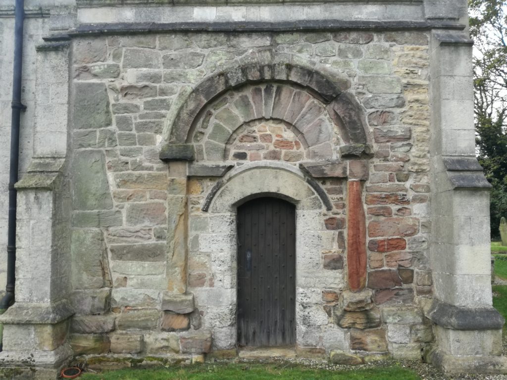
The first reconstruction shows how the elite residence would have looked in the late tenth and first half of the eleventh century. The hall forms the focus of the complex, and this wooden building and any additional structures would have been surrounded by a ditched and fenced enclosure. The protective circuit was found during excavation, and it was even possible to see where wooden posts had been levered out of the ditch when it went out of use. Appended to the hall complex within its own enclosure would have been a stone-built church, a doorway from which survives in the north wall of the present building. Dr Michael Shapland suggests that the first church at Laughton may have been a free-standing ‘tower nave’ construction, for the exclusive use of the aristocracy rather than the wider community. To the east of the hall and church extended settlement and industrial activity, which has been found by previous archaeological investigation. Laughton would have been an important estate centre as well as an elite residence, and was a place where agricultural produce was collected and processed.
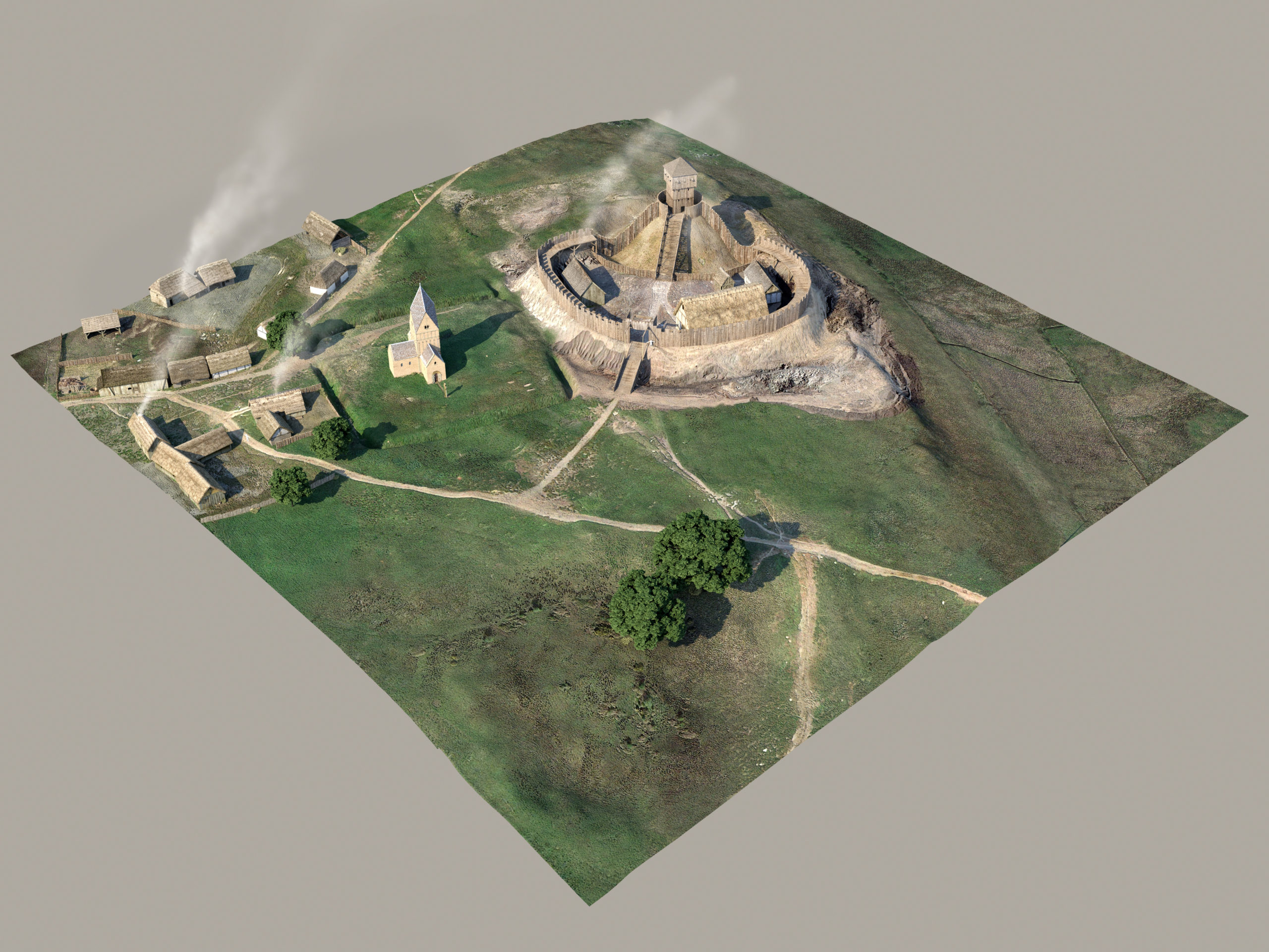
Laughton-en-le-Morthern as it might have been post Conquest (copyright Pighill Illustrations)
The second reconstruction depicts Laughton following the Conquest and after construction of the motte and bailey castle on the site of Earl Edwin’s hall. We cannot be sure when the castle was built, but it was most likely completed before the end of the eleventh century when Norman power in northern England was gradually being established. Laughton at this time was a contrasting picture of change and continuity, with some earlier parts of the elite complex maintained and others adapted or removed. Most obviously, the residential parts of the site were destroyed to construct the castle; excavation showed how the ditches surrounding Edwin’s hall were quickly infilled, and the posts supporting the fence were removed. Geophysics also confirms that the 9m-high motte at Laughton was built direct over the middle of the earlier arrangement, and extended over the western part of the enclosure. The church probably kept its original form in the eleventh century, and was only updated in the twelfth century after it came under the control of York Minster. While investment in the church continued through the twelfth century and later, occupation of the castle seems to have been very short-lived. Excavation identified no material from the later medieval period, and the motte and bailey was not enhanced with stone structures. At Laughton it seems that building of the castle was more important than its actual occupation; construction involved the destruction of Edwin’s residence and the raising of something new that demonstrated the establishment of Norman authority. Nearby Tickhill instead emerged as the most important secular centre in the region.
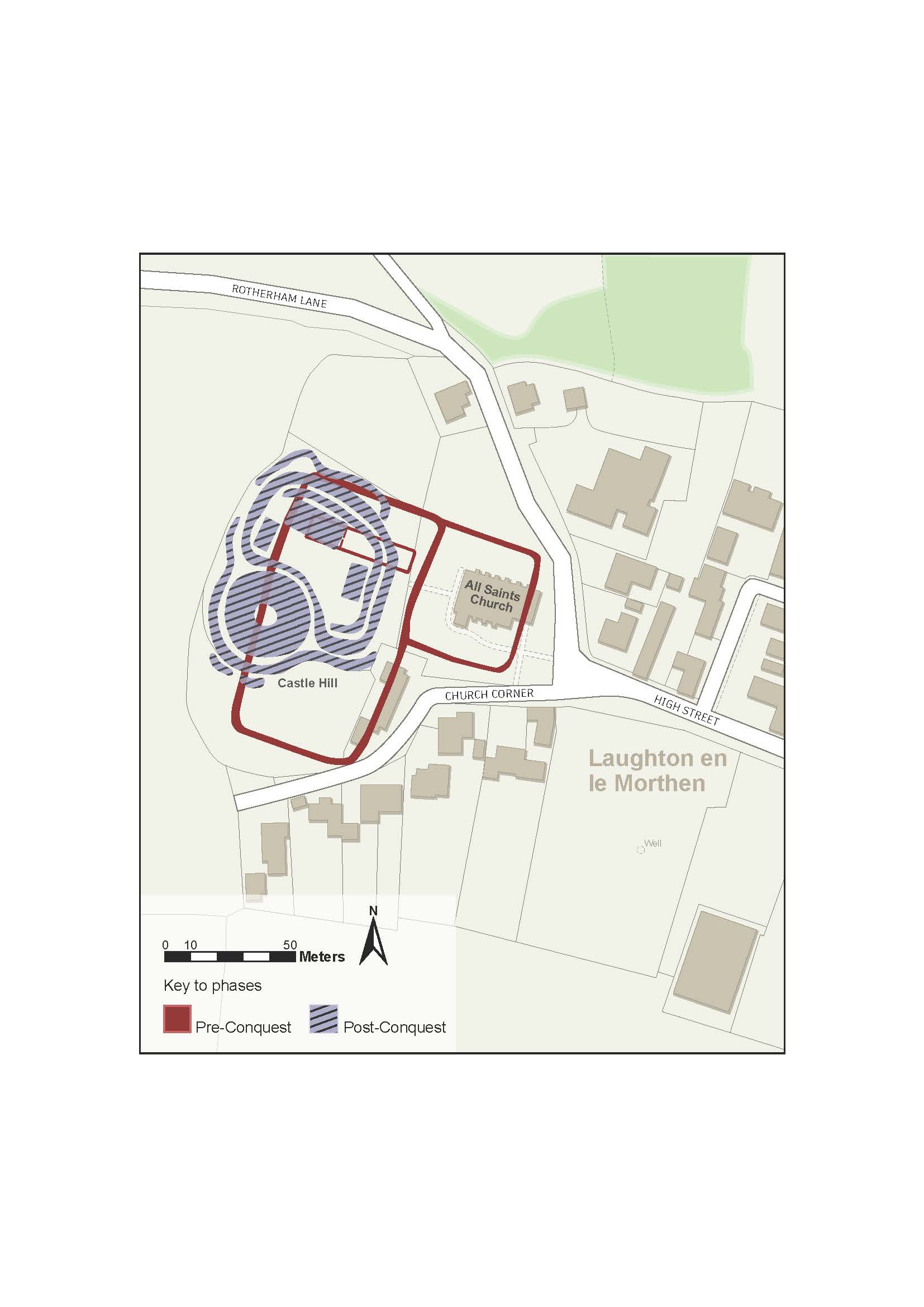
Phased Plan of Laughton en le Morthern
The phase plan outlines the core components of the two chronological periods recognised at Laughton. It makes clear how construction of the castle destroyed and disrupted the earlier elements of the high-status complex.
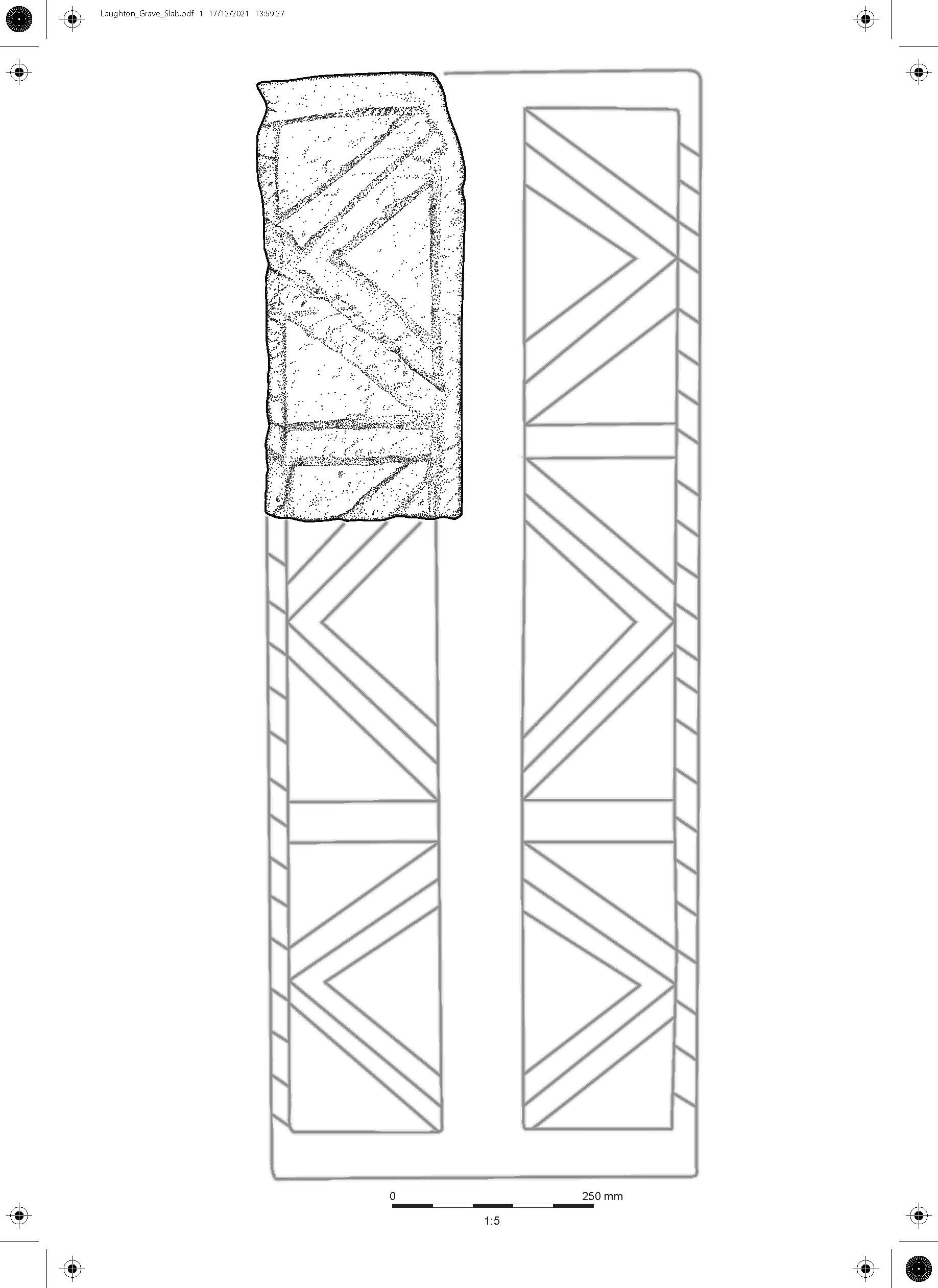
Early grave cover
The stone illustration represents about one sixth of an early grave cover with incised decoration, which was analysed by Professor David Stocker and Dr Paul Everson. This type of monument is well-recognised in eastern England and Yorkshire, and at Laughton the stone can be found built into the eastern wall of the chancel. It is a difficult stone to date precisely, but probably dates to the eleventh century and would originally have covered a burial either within or outside of the church.
Between 2018-2021, the Castle Studies Trust awarded Dr Duncan Wright three small grants to research the castle of Laughton-en-le-Morthen. The aim was to develop an innovative new research methodology to understand the near wholesale replacement of existing lords with incoming Norman tenants-in-chief physically showed itself post the Norman Conquest. Here Duncan explains what that has helped lead to.
In October 2021 the Arts and Humanities Research Council (AHRC) awarded Dr Duncan Wright (Newcastle University) an Early Career Research Grant of £200,000 in support of a new archaeological research project.
Entitled ‘Where Power Lies’, the project will undertake the first systematic examination of the physical evidence for elite centres in the landscape of medieval England between c. 800-1200AD. Many of these high-status places were developed as castles, and the research aims to identify the motivations behind choosing to build a castle at an existing lordly centre, when a site could equally be perpetuated as a manor house or else abandoned altogether.
The success of Duncan’s AHRC bid is partly thanks to the support of the Castle Studies Trust, who funded his research at Laughton en le Morthen (South Yorkshire) with three separate grant awards totalling almost £5000. The work at Laughton, which comprised geophysical and topographic survey, targeted excavation, and the commission of 3D reconstructions, not only helped reveal the complex history of the site but also acted as an important pilot and proof of concept for the new project. Indeed, Where Power Lies hopes to emulate the success of the research at Laughton, and will include some of the same survey techniques, but it will also scale up the focus to look at the national distribution of aristocratic centres with evidence for investment in both church and residential components.
Survey results of geophysical survey of Laughton-en-le-Morthen
After modelling the national picture, the Where Power Lies team will investigate a carefully selected sample of case study sites, which will be subject to topographic, geophysical, and standing building surveys. These investigations will allow us to reconstruct the biography of the case study locations in detail, and to explore how the character and expression of elite power invested in their residential and ecclesiastical complexes evolved over time. Working with the British Museum’s Portable Antiquities Scheme as an official project partner, the research will also produce a new profile of the artefacts of the aristocrats who built and occupied these sites.
By undertaking this work, Where Power lies will shift the focus beyond the relatively small corpus of excavated aristocratic sites of the period which continue to form the basis of our understanding. Instead, by embracing a range of digital technologies and non-intrusive survey methods, the projectwill create valuable new datasets at a number of scales. By generating this new information, the team will demonstrate how the transformation of power centres occurred on the ground, revealing whether castles integrated earlier components into remodelled layouts, or whether they caused greater destruction and a more fundamental schism with the past.
Excavation at Laughton showing remains of a ditch that ran next to a possible entrance way to the Saxon lordly centre.
The team will be led by Duncan as Principal Investigator, who will be accompanied by Professor Oliver Creighton (Exeter University) as Co-Investigator, and a Research Associate who will join the team for the duration of the project. Duncan would like to take this opportunity to thank the Castle Studies Trust for their generous support of his research at Laughton en le Morthen, which strengthened the AHRC bid significantly. He hopes the results of Where Power Lies will prove of interest to everyone associated with the Trust.
In an article that first appeared in Current Archaeology issue 360 (March 2020) Duncan Wright and Samuel Bromage discuss how the two research projects which they undertook at Laughton-en-le Morthen, with CST’s funds, has shown how the siting of castles was influenced by the older patterns of high-status activity in South Yorkshire.
Castles are perhaps the most iconic buildings of the medieval period, which for many are synonymous with feudal warfare and conflict. In spite of this popular perception, the idea that castles were mainly built for military purposes has been questioned for some time, and archaeologists now point to a number of reasons for their construction. In England, even fortifications thrown up in the wake of the Norman invasion are no longer seen purely as tools of martial conquest.
Instead, it is increasingly clear that earlier patterns of aristocratic life were important, and that the manorial residences of the Anglo-Saxon nobility in particular were chosen for the siting of early castles. Such targeting should not come as a surprise—the Conquest is understood as an exercise in elite regime change, which saw the near wholesale replacement of existing lords with incoming Norman tenants-in-chief. Yet, the way in which this transformation physically manifested is poorly understood. Few relevant sites have been subject to excavation, and where archaeological intervention has taken place it has often been piecemeal or of limited size. The Landscapes of Lordship project seeks to improve this picture, and recent work at Laughton-en-le-Morthen in South Yorkshire, funded by The Castle Studies Trust, offers a case study of archaeology’s potential to reveal more about this fundamental aspect of the Conquest.
Anglo Saxon Elements
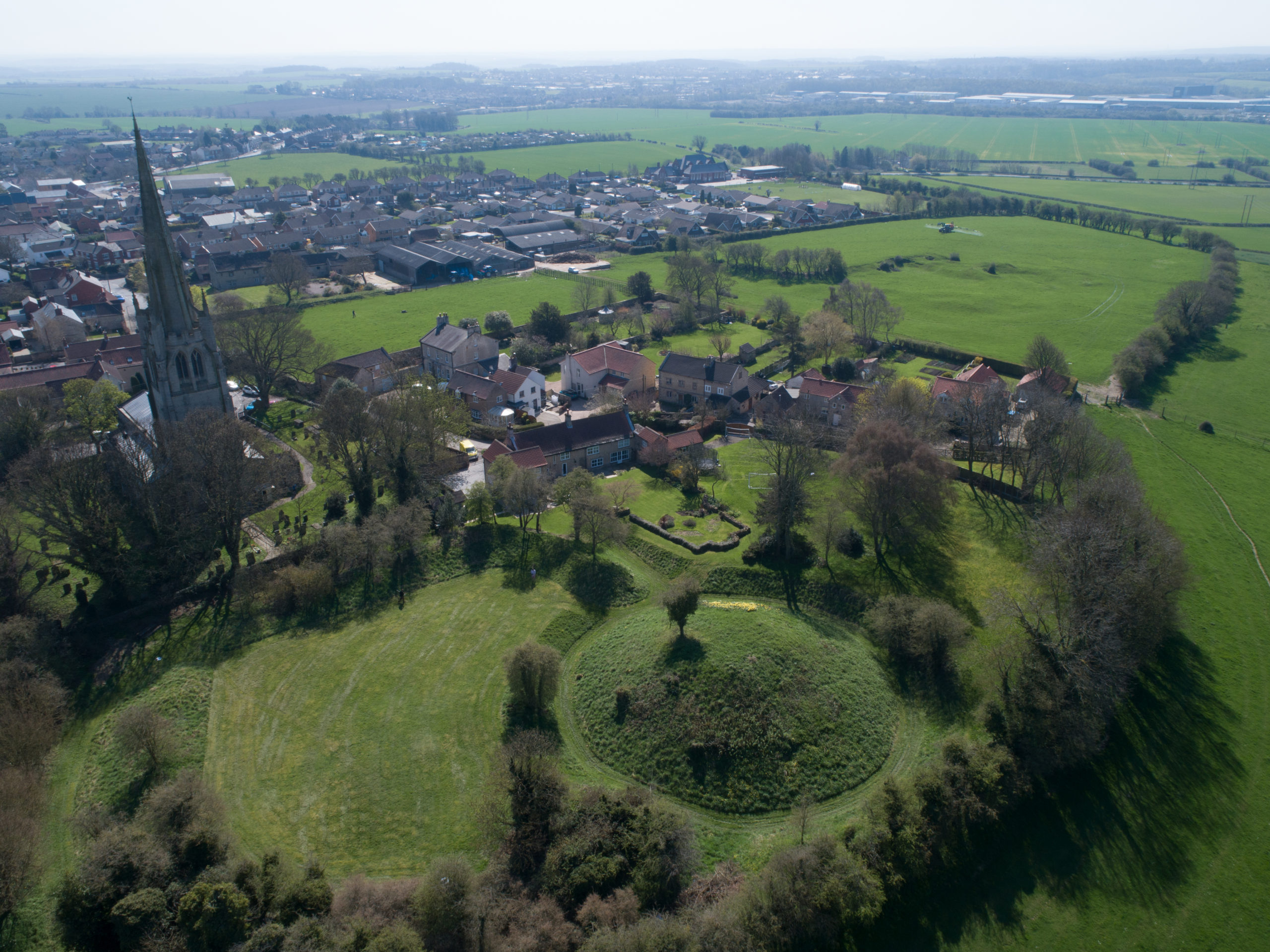
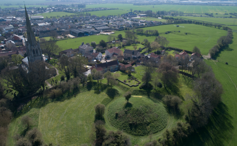
Laughton today is a modestly-sized village in the Rotherham district, perched high on a limestone ridge which offers impressive views, especially westwards towards the Peak District. The historic core of Laughton is focussed around the parish church of All Saints and the adjacent remains of a motte and bailey castle. A visit to the former provides the first hints of Laughton’s early history; an elaborate 10th or 11th-century doorway is located in the church’s north wall, and a similarly-dated grave slab is built into the eastern exterior of the chancel. Inside the church, a triangular-headed opening, a distinctive pre-Conquest form, covers a piscina—a shallow basin used to wash communion vessels. These pieces of stonework indicate the presence of an earlier building at Laughton, decorative fragments of which have been reused in later phases of construction. It is almost certain that this structure too was a church, as stone was almost never used for secular building in early medieval England.
Elaborate C10 or C11 doorway at the parish church.
In 2005 archaeological excavations due east of All Saints also found evidence of pre-Conquest activity, in the form of a circular grain-drying kiln. A significant assemblage of 10th—11th-century pottery was recovered from the excavations, highly unusual finds given that South Yorkshire was largely aceramic at this time. Documentary sources help to provide some context for the excavated material and that found in the church. The Domesday Book records that, prior to the Conquest, Earl Edwin of Mercia had an ‘aula’ or hall at Laughton. Edwin was a leading noble, but also a leading protagonist against the Norman regime. Brother-in-law of Harold Godwinson, Edwin, together with his younger brother Morcar, raised an unsuccessful rebellion against William the Conqueror after the Battle of Hastings. Dispossessed of his extensive lands, Edwin was ambushed and killed three years later.
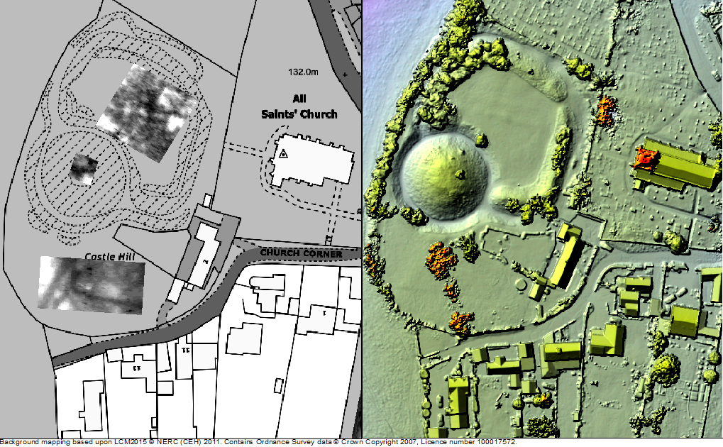
Exactly where Earl Edwin’s hall was located in Laughton has long been a mystery, with the popular belief that it lies under the earthworks of the castle. The Landscapes of Lordship project set out to test this idea, firstly through a scheme of topographic and geophysical survey. A detailed topographic model of the castle and the surrounding parts of the village was made using a drone, and earth resistance survey provided a plan of buried features from the bailey and an area of open ground to the south. The results from the combined techniques exceeded even the expectations of the team, identifying a host of important archaeological features. In the bailey, geophysics picked up a number of anomalies which were also detectable as a low earthwork—the size and shape of which is consistent with buildings, and probably represent the centre of Earl Edwin’s hall complex. To the south of the bailey, ditches seemed to form two sides of an enclosure, one side of which was interrupted by the apparent construction of the motte.
Survey results from the first year of research funded by the CST
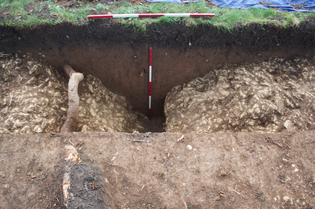
Although the project team were confident that these features were related to Edwin’s estate centre, it was decided that a targeted excavation would be best to confirm this conclusion. A second phase of work, also supported by the Castle Studies Trust, was instigated to ground truth some of these findings, with two trial trenches dug over the ditches to the south of the castle. Excavations uncovered a V-profile ditch with a distinctive narrow base, which would have served to locate a wooden palisade, supporting the premise that this was indeed Edwin’s compound. No datable material was recovered from the ditch but the material inside was notably clean and consistent, indicating that infilling had occurred in a short window or perhaps as a single event. Beyond the enclosed area, another more substantial ditch was found—this feature seemed to project southward from the castle and may be part of an enclosure surround the village, the form of which is preserved in the historic street plan.
Hunting the Hall
The Landscape of Lordship investigations, then, support the idea that Laughton was indeed the site of Earl Edwin’s ‘aula’ and other buildings, which were surrounded on all sides by a ditched enclosure enhanced with a palisade. Edwin and his entourage would have had exclusive use of the elaborate stone church, which topographic evidence demonstrates lay within its own small rectilinear churchyard. Outside of this high-status enclave, the find of a drying kiln suggests that Laughton acted as a point for the collection and processing of agricultural produce, potentially from an extensive area. Indeed, Laughton was the centre of a large territory incorporating several later parishes, the component settlements of which are now most discernible by their ‘Morthen’ place-names.
Ditch found during the excavation
At some stage, Laughton’s lordly compound was radically transformed—the palisade fence was taken down and the ditches rapidly filled in; in their place was constructed a massive earthwork motte across the western edge of the enclosure. A kidney-shaped bailey incorporated the most important buildings including the hall, but it is impossible to tell without more investigation whether these were maintained or replaced with new structures. Probably around the same time the settlement to the east of castle and church was surrounded by a rectilinear enclosure, effectively forming an extensive outer bailey of the castle. Such arrangements are not uncommon in England but perhaps the most famous is at Pleshey in Essex, where a semi-circular bank and ditch encircles the village to the north of a motte and bailey castle.
While the nature of the archaeological evidence does not provide absolute dates, the most compelling context for the apparently rapid changes visible at Laughton is the protracted conquest and subduing of northern England in the years following the Norman invasion. Once annexed, Laughton and its estate were quickly subsumed into a large territory given to Roger de Busli who established a centre at Tickhill where a sizeable castle was erected. Given that the main seat of authority lay at Tickhill, it is unusual that Laughton too was furnished with a castle and that it continued to act as an administrative focus at least temporarily. The explanation for Laughton’s perpetuated importance undoubtedly lies in its pre-Conquest past. As an important residence of Earl Edwin, a foremost member of the Anglo-Saxon elite, Laughton’s appropriation was clearly an attempt to assume a recognised place of power. Yet, the drastic overhaul of the site also embodies a conspicuous act of conquest, physically destroying the complex of a central opponent to Norman rule. It is possible that the processes of castle construction in itself was its raison d’être, acting as a material ‘seal’ of new authority in the eleventh-century landscape. Indeed, this may help explain the paucity of medieval finds from the excavation—the castle itself having experienced little or no use, as its primary purpose had already been met by its very building.
The work by the Landscapes of Lordship project has provided a unique insight into Laughton’s past, showing the importance of older patterns of high-status activity in shaping the process of castle siting in South Yorkshire. The project team now intend to employ this approach to further sites and regions, allowing a new archaeology of elite residence, conquest, and regime change to be written.
Duncan W Wright was Senior Lecturer and Programme Leader of Archaeology and Heritage at Bishop Grosseteste University, Lincoln during the project and has recently been appointed Lecturer in Medieval Archaeology at Newcastle University
Samuel Bromage is a PhD researcher at the University of Sheffield. His doctoral thesis investigates the consequences of the Dissolution for urban development in Yorkshire.