Ballintober Castle – revealing the past of the former O’Conor caput

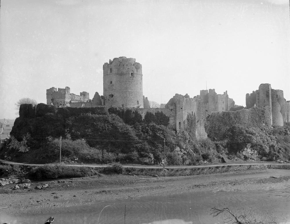
In the Castle Studies Trust’s first year of grant awards it gave a grant to survey Ballintober Castle in County Roscommon, caput of the O’Conors. Project lead Niall Brady explains below how that work has been built on and what has been discovered since.

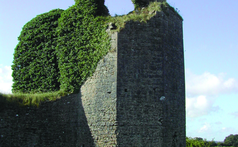
The Castle Studies Trust grant of 2014 for Ballintober Castle permitted a detailed baseline topographical survey of the 14th-century Anglo-Norman castle, constructed in the early 1300s by Richard de Burgh, earl of Ulster, and taken over by the O’Conor kings of the Connacht before the end of the century, after which it became the caput of the O’Conor Don line and was lived in continuously until the O’Conors abandoned the castle for more suitable accommodation at nearby Clonalis House in the 1700s.

Subscribe to our quarterly newsletter

Location of excavation cuttings 2015-2018, by Dan Cearley

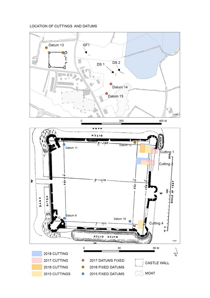
The castle remains a striking ruin in the small village of Ballintober and access to the site is prohibited because of its dilapidation. The 2014 survey feeds into a long-term plan by the O’Conors who retain ownership to rehabilitate the site so that it can be accessible once again and enjoyed. Since 2015, the Castles in Communities research fieldschool has taken a leading role in developing this initiative as a community-engaged anthropological and archaeological Summer fieldschool that sees groups of up to 70 students and staff coming over from America in July, working closely with the O’Conors in Clonalis House and the village represented by the Ballintubber Tidy Towns organization. Additional survey, coupled with geophysical survey, field survey and excavation has made great strides in revealing the complex history of the castle, while a conservation management plan for the castle was completed independently in 2016.

The fieldschool’s work has also extended outside the standing walls of the castle. In reaching eastwards across the present-day village, the project has confirmed the presence of a deserted settlement that would have been integrally related to the castle. In short, Castles in Communities has revealed the deserted manorial village that was associated with the castle and the findings indicate that the medieval settlement footprint was fully twice the size of the present-day village. Excavation within the deserted settlement area is focusing on taking cross-sections across former property plots and the houses within.


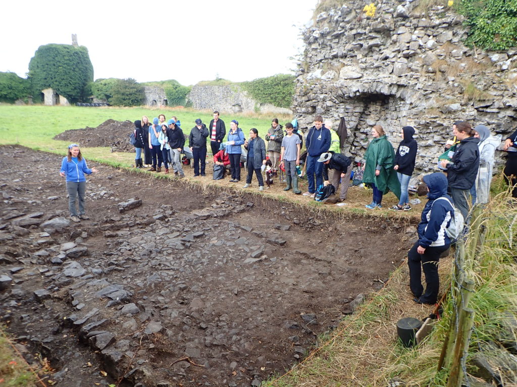
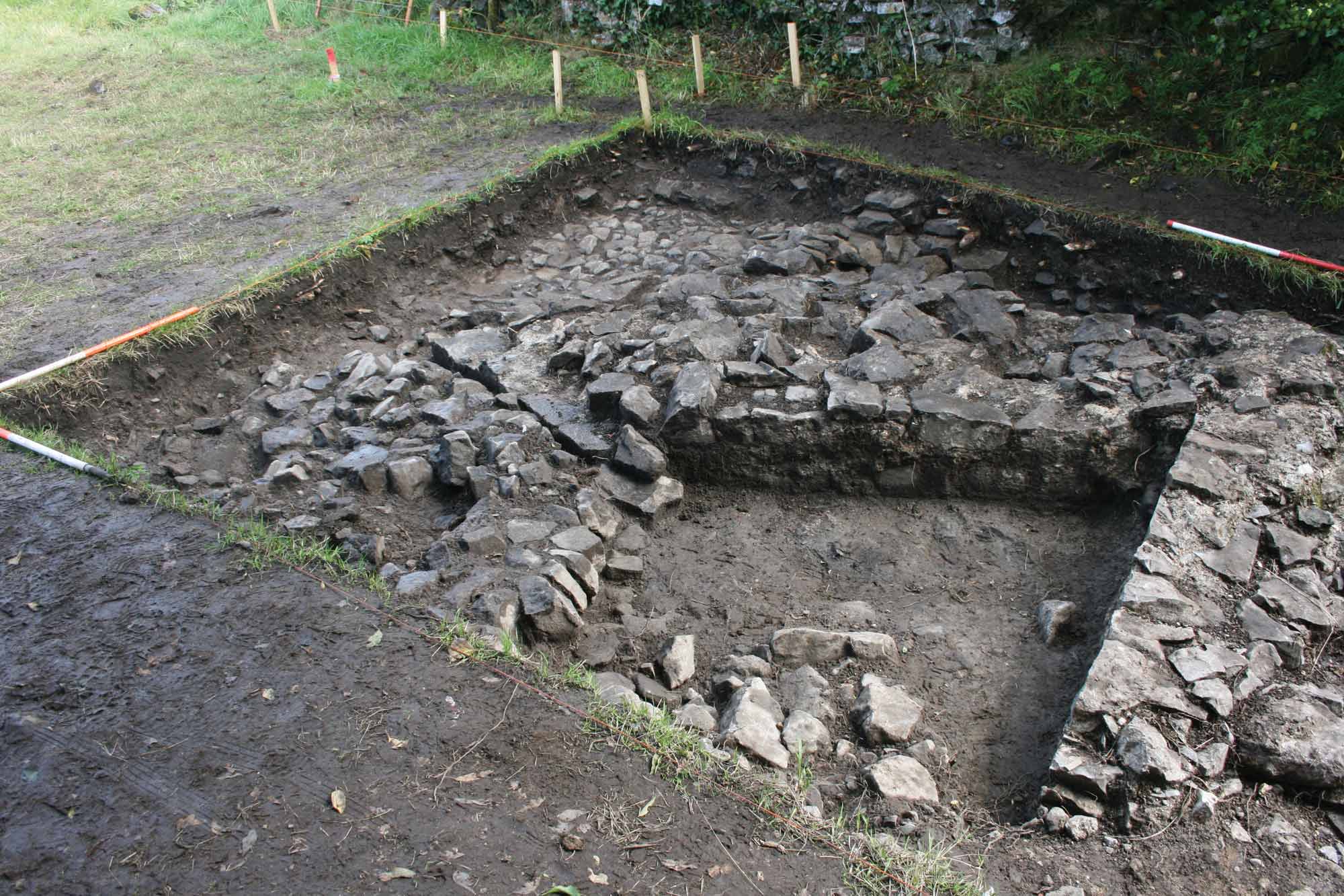
Photograph of cutting opened along the castle entrance in 2019, where evidence for two principal phases of construction have been identified. Siobhan Boyd, project director, explaining the findings.

Excavation inside the castle has progressed along the east side of the interior, where perimeter walls are lower and there is no risk of destabilizing standing remains. Attention has focused on the corner towers, and the perimeter wall. The southeast corner tower is circular in plan but its interior was robbed-out at some point in the past, leaving only a narrow and thin occupation deposit that retained post-medieval ceramics. The northeast corner tower is rectangular in shape, and excavation revealed a large building joined to the tower and running south from it. That building is late in the construction sequence and is itself joined to an earlier masonry structure that lies inside the walled perimeter. The indications for an early phase of castle building that might pre-date much of the standing perimeter walls is also indicated at the castle entrance, where excavation has begun to reveal two distinct phases of construction.

Subscribe to our quarterly newsletter

The project will continue in 2021 after Covid-19 restrictions are lifted.

Niall Brady

Project Director (one of 6)

Castles in Communities

https://sites.google.com/view/irelandcastlesincommunities

email: nbrady@adco-ie.com

Re-imagining Wressle Castle

Reconstructions are a wonderful tool for showing how places looked in their heyday. I contacted Peter Brears to ask about sharing one of his drawings of Wressle Castle in Yorkshire and he sent this magnificent illustration:

Wressle Castle is a quadrangular stone building. There is a river in the foreground, a village to the right, and gardens next to the castle and behind it.
Wressle Castle by Peter Brears, based on the 2014 survey. Click the image to enlarge.

One of our very first grants supported a survey by Ed Dennison Archaeological Services of the landscape around Wressle. It was more than just a castle, it was practically a palace. Wressle Castle was built for Thomas Percy in the 1390s: he was a royal favourite, and his family was one of the most powerful in northern England.

However, the ruins you can see today are just a small part of the castle which was slighted several time between 1646 and 1650. Peter’s drawing is based on our 2014 survey: you can see the gardens to the north and south of the castle, and in the small strip of land between the moat and castle. The  lower court and village are just to the east. And perhaps best of all, the castle is intact with all four sides.

If you happen to have access to The Archaeological Journal, Peter’s other reconstructions of Wressle are definitely worth a look.

Most importantly, thank you Peter for sharing this drawing, it really brings the castle back to life!

Robert the Bruce and Windsor Castle: what you didn’t know about Tibbers Castle

Robert the Bruce is famous for leading Scotland in their wars with England in the early 14th century. He became king in 1306 and embarked on an unprecedented campaign. What you might not know is that to achieve his aims he demolished (this act is known as slighting) many of the castles in Scotland to prevent the English from using them. A chronicler writing in the 14th century remarked that “Robert Bruce had all the castles of Scotland demolished, except Dumbarton”.

Bruce adopted this policy from 1307, which explains why when he captured Tibbers Castle from the English in 1306 it was left standing. This allowed the English to recapture it soon after. The Scottish king had witnessed enough siege warfare to appreciate the role of castles and how pivotal they were to the English plan to control the country, and when he wrestled control of Edinburgh, Stirling, and Roxburgh in 1314 he set about dismantling them so that they could not be used against his own countrymen.

Today Tibbers mostly survives as a series of large earthworks with a little masonry above ground. Walking round you find some rubble tumbled down the ditches around the outer bailey and the motte, giving just a hint at what once stood here. You wouldn’t know it to look at Tibbers, but it seems that when the Scots recaptured the castle in 1313 it avoided the fate of many other fortifications in the region and was left intact.

Funding from the Castle Studies Trust and Historic Scotland allowed this site to be re-examined. A geophysical survey was carried out and a new plan of the site was carefully drawn. This research gave new insight into the early form of the castle. It found that early in Tibbers’ history the castle probably consisted of a motte with a single small bailey. When the earth and timber defences were replaced in stone the single bailey was replaced by two much larger enclosures, giving the castle the form we recognise today. This double-enclosure arrangement is quite unusual for a motte-and-bailey castle. You can see another example at Windsor Castle where the motte is flanked by two baileys.

The work at Tibbers was our first contribution to Scottish archaeology; in fact it was one of the very first grants we gave out back in 2014. Built in the 12th or 13th century, changing hands several times during the Anglo-Scottish Wars and then descending through the earls of Moray and the earls of March before being taken over by the Scottish monarchy, Tibbers has a storied past. Fortunately we have been able to add a few details to that colourful history.

Click here for the full report from RCAHMS on the survey, with a potted history of the site.

Wressle, a castle with personality

We often think of castles as formidable fortifications around which the medieval world pivoted. Fierce sieges were invested to capture key sites; the Keeper of the Tower of London was a prestigious role, and Dover Castle was the ‘key to the kingdom’.

But castles also had a domestic side. They were residences of the barons, earls, and monarchs who ruled in medieval society.[1] They were decorated with rich tapestries as seen at Chateau d’Angers in France, the scene of magnificent feasts, and wrapped up in symbolism. The Earl of Cornwall built a castle at Tintagel because the place was linked to Arthurian legend.

Personalities are intricately linked to the story of each castle, not always those who owned them. Thomas Percy built Wressle Castle in the 1390s. The Percy family was a powerful dynasty in northern England and Wressle was a fortress-palace within carefully constructed garden. Designed by John Lewyn, one of the leading architects of late 14th-century England, the castle had only recently been completed when the fortunes of the Percy family took a turn for the worse.

In 1403 Harry Hotspur, Thomas’ nephew, rebelled against King Henry IV with a string of grievances. Thomas joined the rebellion which was eventually defeated the battle of Shrewsbury. Thomas was captured and executed for his role and the Crown took control of Wressle Castle.

For nearly 70 years the castle either remained with the Crown of was temporarily given to favourites of the king. In 1471 it was finally returned to the Percys, with Henry Algernon Percy making his mark on the castle by updating the interior and the gardens. The gardens contained a two-storey building call the ‘School House’ with paintings of proverbs across the interior. This may have been where Henry Algernon Percy came for some quiet reading.

Wressle Castle never witnessed a siege, though it was garrisoned during the English Civil War in the 17th century. In fact the majority of castles never faced the attacks they were designed to withstand. Despite that the castle lies in ruins today. The garrison themselves left their mark, causing damage estimated at £1,000! After the war the castle was partly demolished, leaving just a quarter standing which can be seen today – though it is on private land. The following century the interior was stripped by fire when a tenant tried unsuccessfully to clear a blocked chimney.

Wressle has a rich history which the survey we funded in 2014 and carried out by Ed Dennison Archaeological Services shed further light on. When Thomas Percy decided he wanted a castle in the late 14th century the village of Wressle lay in the way. The settlement used to extend further to the west, but was pulled down to make way for the castle gardens.

Castles have a direct impact on local communities, and those castles are shaped by the personalities that live in them, who drag them into disputes, and who occasionally fail to unblock chimneys. Next time you’re at a castle take a moment to learn about the people who shaped the building you’re standing in and think what it must have been like.

Want to know more about Wressle or our other projects? Watch our video about the landscape survey or sign up to our newsletter.


[1] Catriona Cooper at the University of Southampton used digital media to explore the experience of living inside a medieval castle, looking at Bodiam and Ingtham Mote.

Art as history

Recently a re-examination of an 18th-century painting of Caus Castle in Shropshire helped piece together some of the castle’s history. It was prompted by mentioning the ongoing work at Caus on social media which shows how valuable it can be and how people can get involved.

Paintings and drawings are a useful resource, and while they are typically not meant as a pinpoint accurate record of what they depict, they can offer a guide. When used carefully they can be a very useful resource. There are wonderful medieval miniatures, including details of the siege of Bedford Castle in 1224 and this 14th-century image of a siege.

Some of my favourite images are by the Buck Brothers, engravers working in the mid-18th century. Their images are just wrong enough to remind you that these are not infallible records, but good enough to show how these buildings looked more than 250 years ago.

The National Library of Wales has digitised some of their collection and made it freely available online. With that in mind, here are a few historic images of Holt and Pembroke Castle, all of which are in the public domain.

Exploring Richard II’s treasure house – a tour round Holt Castle

Holt Castle was built in north Wales by John de Warenne, the Earl of Surrey, and dates from an age in which the country was transformed. Edward I’s campaign to conquer the Welsh in the 1280s led to the creation of towns and some of its most iconic castles.

The great sandstone walls were once owned by royalty. Richard II confiscated Holt Castle in 1397 and under his ownership the castle was revitalised. It became one of his favourite properties and he used it as a treasure house, storing £40,000 there. If it wasn’t for the Civil War of the 17th century Holt’s unusual pentagonal design and imposing architecture would have made it as recognisable as Beaumaris, Caernarfon, or Harlech.

Instead in the 1640s Holt Castle was demolished and its stone used to build Eaton Hall. Centuries on, it is hard to picture how this once great castle would have appeared. To help with this the Castle Studies Trust supported Rick Turner and Chris Jones-Jenkins in digitally recreating Holt as it would have appeared around 1495.

If you have been following our work, you may already have seen in Current Archaeology or BBC History Extra how Rick and Chris brought together a range of sources to create this unique model. If you haven’t, those pieces are certainly worth a read.

It is important that what we do is available for everyone. That is why when our projects are complete you can find the results on our website. With this model it has even been published under an open licence so it is free to reuse. This can lead down some interesting avenues. One blogger, Megan Whalen Turner, even been called “A perfect starter home for Fantasy Authors”!

As well as video sharing websites we also uploaded it to Wikipedia. Until recently you could read about Holt Castle in English, Welsh, and Spanish. The video has inspired more interest, and now you can read about this 13th-century castle in French, Italian, Catalan, Finnish, Basque, and Swedish.

Want to know what we will be doing next? Sign up to our newsletter.

Ballintober: a palace castle in a border territory

An enigmatic ruin

County Roscommon’s Ballintober Castle was probably built by Richard de Burgh, Earl of Ulster, in the early 14th century. It changed hands several times, but from 1381 it was under the control of the O’Conor family. After nearly being attacked in 1642, the castle was abandoned as a residence and the elements have left Ballintober as a ruin. The O’Conor family still own the castle today.

Despite Ballintober’s storied past and impressive ivy-clad remains, archaeologists first investigated the castle in 2008. When Niall Brady applied to the Castle Studies Trust for funding in 2013 the project to survey the castle offered the chance to push forward our understanding of the castle.

Though the castle now lies in ruins, parts of it stand up to 4m high (13ft). Ballintober Castle is rectangular, measuring 73.8m by 80.5m (242ft by 264ft). There is a tower at each corner, and on the east side the entrance is flanked by two further towers. The polygonal corner towers are thought to emulate the design of Edward I’s Caernarfon Castle in Wales. As well as being a military structure, emulating the most powerful of royal castles, Ballintober was a residence. Its comfortable accommodation revealed by the fireplaces marked it as a palace castle.

Ballintober is a ‘keepless castle’ which means it does not have a great tower such as the one seen at Trim Castle (Ireland) or Dover Castle (England). Instead it relied on its outer walls. There are a few castles like Ballintober. Richard de Burgh also built Ballymote as a keepless castles around the same time.  Just 18km (11mi) to the south-east is Roscommon, which may have provided the template for Ballintober. It was built decades earlier in 1269 on behalf of Henry III. Ballintober is the largest keepless castle in Ireland, and is more than twice the size of Roscommon despite its royal patronage.

Surveying the ruins

Laser scanning equipment at a castle
The laser scanning in progress at Ballintober.

Laser-scanners were used to record the standing structure and as a result we have a 3D point cloud which can be used to create accurate plans, elevations, and views. The survey took three days to complete in the field, followed by considerable time processing and interpreting.

It’s told us a lot about the castle. The south-west tower has a fireplace on the ground floor, and would have once had a fine timber vault. It may have housed a high-status hall. While it’s possible the south-east tower is the oldest as it is the smallest of the corner towers, the north-west tower was substantially redesigned in the 17th century. The arrow slits are wider than those found at Roscommon and Ballymote, and may be wider. This might suggest that comfort was a consideration in their design. There are signs of later adaptation, with gun loops being added to accommodate gunpowder weapons.

The survey also shows that Ballintober Castle is asymmetrical, with the entrance off centre. One possible reason is that the design changed to encompass a larger area or perhaps it stands on an earlier fortification.

An eye to the future

Importantly, the survey paves the way for future work: from July to August this year Foothill College, California, ran a Summer Fieldschool at the Castle. ‘Castles in Communities’ is advertised on the Archaeological Institute of America website. Niall Brady was one of the fieldschool directors. We asked him how the excavations went:

“The CST-funded survey in 2014 was a very important precursor to starting the present work. The 2015 season went well. We focussed on questions associated with tracing missing lengths of the standing walls, rather than looking into the main interior. This was to give us some sense of the site’s stratigraphy, while also tackling obvious questions in a way that wouldn’t open a can of worms we couldn’t close. We also engaged the attention of a conservation engineer, who is now quite excited by what can be possible in future years, vis a vis conservation works on the standing remains.

“For the four weeks on site, the excavation results were good, showing 16th-century and later levels. We only really broke the ground surface in three discrete locations, and so look forward to going deeper and exposing medieval horizons next year. There was massive buy-in from the local community (the landowners and the villagers), who see the great potential that lies in our plans for the castle site and its living community about it.”

Excavations in the southeast corner tower, exposing phases from the castle's broad history. Photograph by Nialll Brady.
Excavations in the southeast corner tower, exposing phases from the castle’s broad history. Photograph by Niall Brady.

The work the Castle Studies Trust is not the end point of a journey, but a crucial stepping stone towards understanding medieval society.

For more information on Ballintober, read the full length report prepared by Niall Brady. Please donate so we can support more projects like the one at Ballintober.