Where Power Lies: the archaeology of transforming elite centres in the landscape of medieval England c. AD 800-1200

Between 2018-2021 the Castle Studies Trust awarded three grants totalling less than £5,000 to Dr Duncan Wright of Newcastle University to develop a new methodology to understand the transition from Saxon to Norman rule at elite sites using Laughton-en-le-Morthen in South Yorkshire as an case study. This was then used to successfully win an early career research grant from the Arts and Humanities Research Council in 2022. Here is an update from Duncan about the project.

For the past 14 months a team from Newcastle University and the University of Exeter has been carrying out the first project dedicated to understanding the archaeological evidence for the origins of medieval power centres in the landscape of rural England. Where Power Lies has explored data at a number of scales, with a particular focus on places where elites developed a residential and ecclesiastical component in a single enclave. Importantly, the chronological remit of the programme straddles the Norman Conquest, allowing us to see with greater clarity the way in which castles were integrated and, in some cases, disrupted existing patterns of aristocratic activity and investment.

Subscribe to our quarterly newsletter

Among the first work packages initiated by the project team was a national GIS (Geographic Information Systems) of all of the ‘big data’ evidence for lordly centres, including the Corpus of Romanesque Sculpture in Britain and Ireland, and locations of the earliest castles. From this nationwide picture, the project targeted two ‘macro’ study regions, one focussed on the South/Southwest, and a second in North-East England. The Historic Environment Records for each county in the macro regions was then mined for useful data, helping us to identify a large number of new sites and to some extent map regional trends and differences in medieval elite activity. While such datasets must always be treated with care, this work immediately showed the frequency with which lordly complexes incorporate or are adjacent to watermills, strongly suggesting that mills and milling were central not just in the siting of aristocratic cells but also in the economic and symbolic foundations of elite power from the outset.  
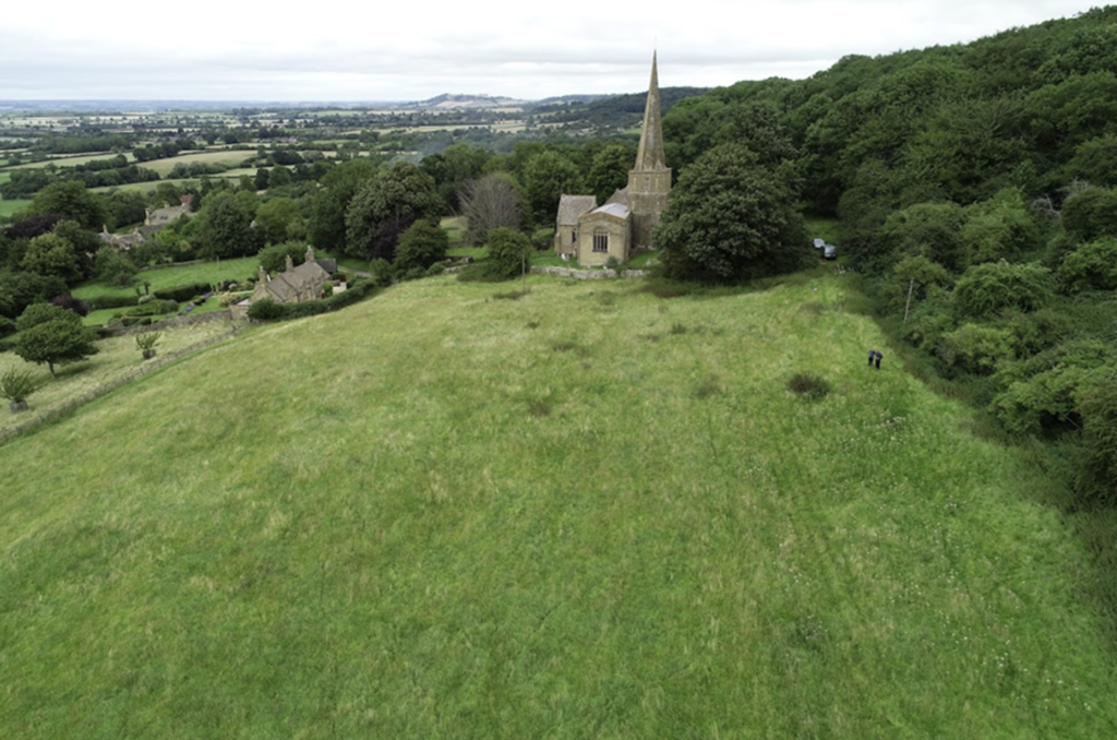
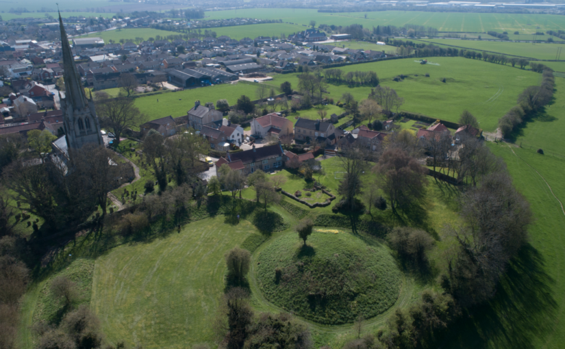
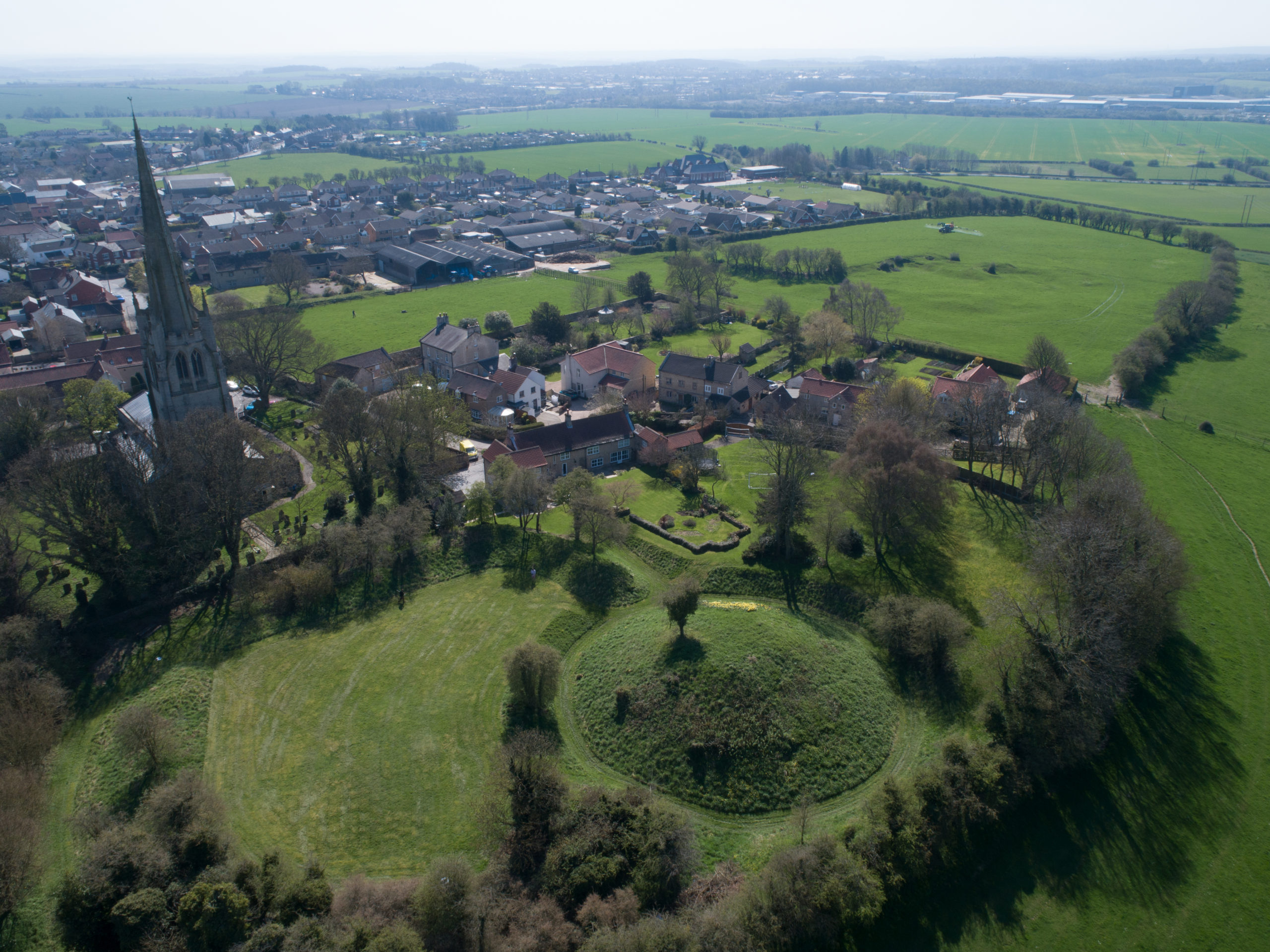
Figure 1: Aerial view of St Nicholas, Saintbury, and the earthworks to the west of the church. The complex has formed a key case study for the project copyright Where Power Lies

Where Power Lies has also conducted a programme of more comprehensive study focused on individual lordly centres. As a result, the project has been able to reconstruct something of the earliest phases of these places, identifying both commonalities and distinctions in what is usually seen as a homogenous category of archaeological site. One of the project’s main case studies has been Saintbury, Gloucestershire, where a series of prominent earthworks lie immediately south-west of the Romanesque church of St Nicholas (Figure 1). Despite the correlation of early church and impressive earthworks, almost no previous study had been undertaken at Saintbury until the Where Power Lies team conducted fieldwork in three phases in 2023; geophysical and standing building survey were conducted in July, excavation for optically stimulated luminesce (OSL) profiling and dating samples in September, and topographic survey and 3D modelling via drone in November.
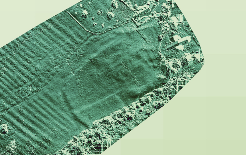
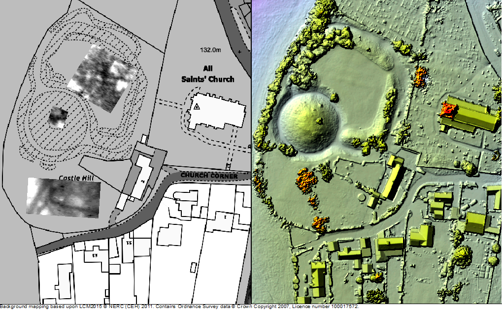
Figure 2: Topographic model derived from drone data of St Nicholas, Saintbury, and the earthworks west of the church. The inner and outer enclosures of the complex are clearly visible, and probably represent periods of Roman and medieval occupation on the site.

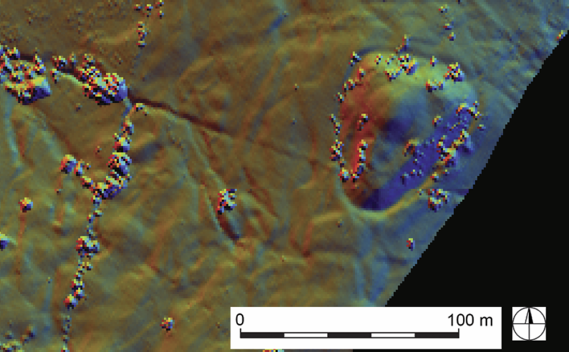
While we’re still awaiting the OSL dates that will allow us to phase the earthworks, our research has already made some key breakthroughs. It now appears that Saintbury’s lordly centre was developed on a pre-existing Roman site, perhaps a villa or even a military installation of some kind (Figure 2). In the early medieval period the earlier Roman complex was transformed, perhaps into an ecclesiastical community; several pre-Conquest charters relating to neighbouring estates mention ‘Cada’s Minster’ (cadan mynster) and, while the minster has previously been located at the nearby hillfort of Willsersey Camp, the earthworks adjacent to St Nicholas could well instead represent this early church. St Nicholas itself was constructed c.1100, at a time when the aristocracy were again investing heavily in Saintbury’s landscape. The appropriation of minsters for elites for their private use was increasingly common from the mid-ninth century, and at Saintbury we may be seeing an archaeological example of this process of secularisation. Not only is the residence adjacent to the church at Saintbury likely to have been enhanced, a previously little-recognised motte and bailey castle was also constructed around the same time 1km to the south-west (Figure 3). Whether the result of a divided manor, or an additional military installation to an existing lordly centre, the castle was certainly thoughtfully located; not only near to where the Roman Ryknild Street drops down the Cotswold scarp, but in close proximity to an early medieval assembly place called the Kiftsgate Stone (Figure 4). Our Saintbury case study is just one of several that the project has undertaken that not only neatly encapsulates the complexities of evolving aristocratic activity in the period, but also shows the value of concerted study of specific sites and landscapes.
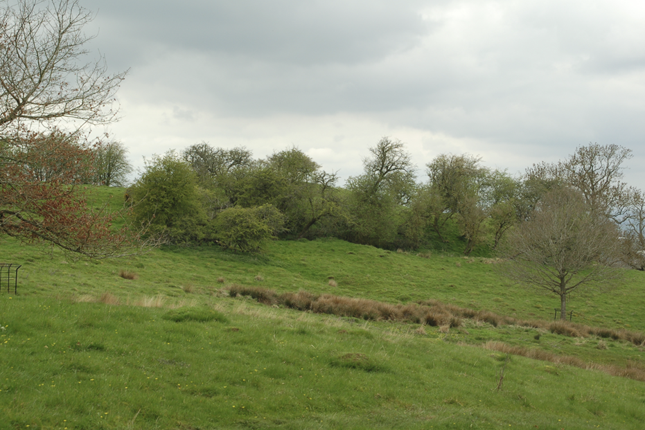
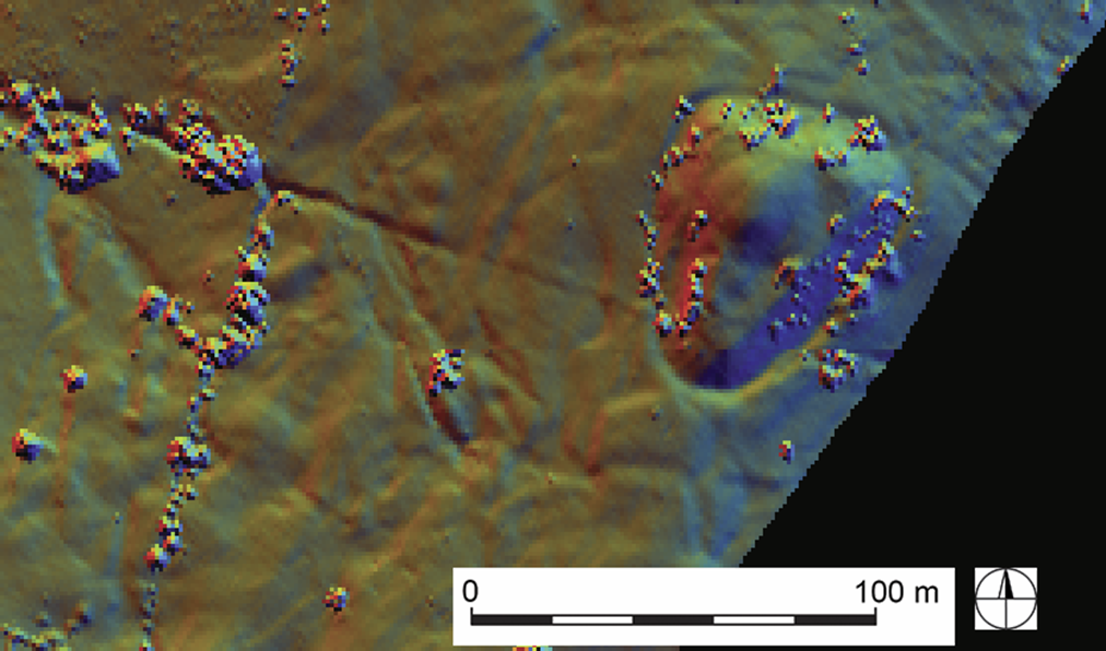
Figure 3: The tree-covered earthwork of the motte and bailey castle at Weston Park, Saintbury. The reuse of the monument in the post-medieval period as a prospect mound may partly explain why the castle has been overlooked by previous scholarship. Copyright Where Power Lies
Figure 4: LiDAR data of the motte and bailey at Weston Park, Saintbury. The monument has been sculpted to form a prospect mound for the nearby house, but was clearly originally a castle of the eleventh or twelfth century. 

Moving into its final few months, Where Power Lies is now integrating the findings from these different scales of work into a number of different outputs. The success of the project is partly down to the support of the Castle Studies Trust who generously funded three stages of a pilot scheme at Laughton en le Morthen, South Yorkshire, the results of which were recently published in Landscapes. The monies provided by the Castle Studies Trust were critical in allowing us to demonstrate the methods and concept behind Where Power Lies, resulting in an AHRC (Arts and Humanities Research Council) research grant for our 18-month long project. The project team hope that we can in some way repay this generosity, by placing early castles into a more coherent, longer-term picture of aristocratic development in the landscape of England.
Subscribe to our quarterly newsletter

From Edwin’s hall to Roger’s castle: the elite residence of Laughton en le Morthen, South Yorkshire

Since 2018 the Castle Studies Trust has funded archaeological investigation of the motte and bailey castle at Laughton en le Morthen, South Yorkshire. Led by Dr Duncan Wright of Newcastle University, a scheme of topographic and geophysical survey, followed by targeted excavation, showed that the castle at Laughton had been built on an earlier elite residence—almost certainly the hall complex of Earl Edwin of Mercia referred to in Domesday Book. The results of the fieldwork therefore show us how an existing high-status centre was transformed into a castle in the wake of the Norman Conquest. Using a combination of the evidence gathered in the field, and comparison with similar centres in the country, researchers are able to reconstruct the chronological development of tenth and eleventh-century Laughton with some confidence.

Subscribe to our quarterly newsletter

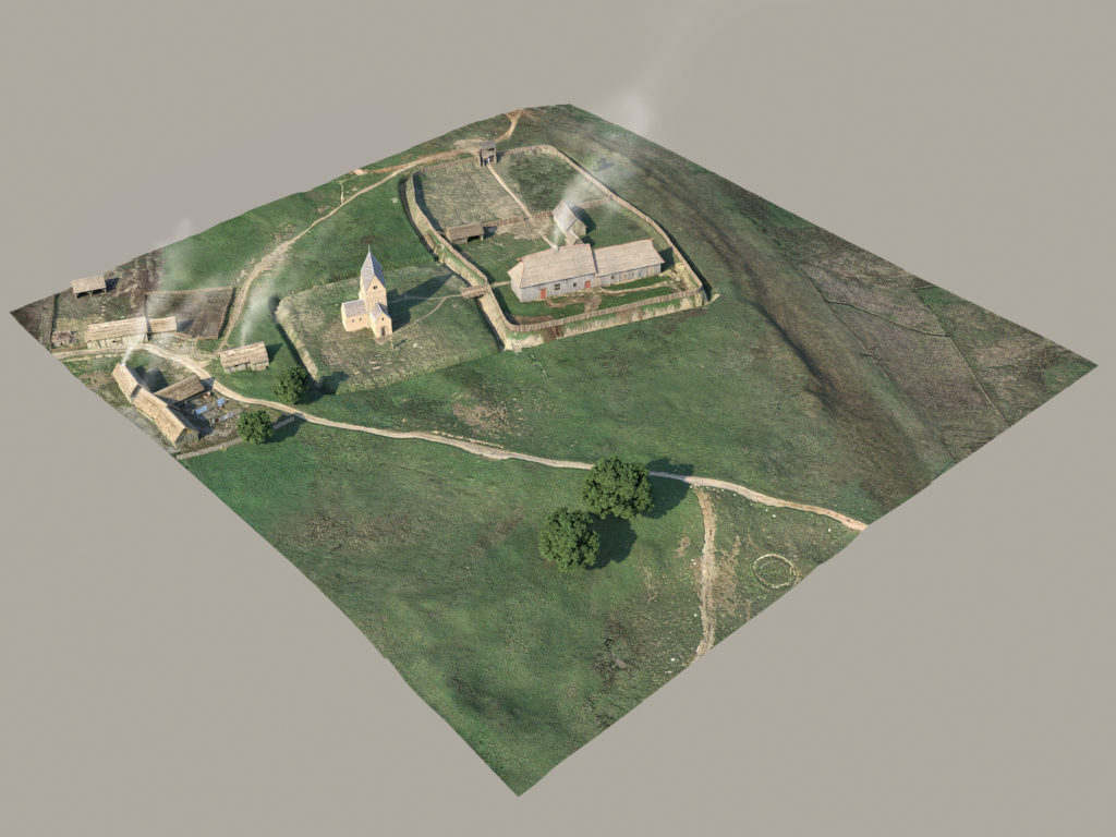
Laughton-en-le-Morthern as it might have been pre-Conquest (copyright Pighill Illtustrations)

The first reconstruction shows how the elite residence would have looked in the late tenth and first half of the eleventh century. The hall forms the focus of the complex, and this wooden building and any additional structures would have been surrounded by a ditched and fenced enclosure. The protective circuit was found during excavation, and it was even possible to see where wooden posts had been levered out of the ditch when it went out of use. Appended to the hall complex within its own enclosure would have been a stone-built church, a doorway from which survives in the north wall of the present building. Dr Michael Shapland suggests that the first church at Laughton may have been a free-standing ‘tower nave’ construction, for the exclusive use of the aristocracy rather than the wider community. To the east of the hall and church extended settlement and industrial activity, which has been found by previous archaeological investigation. Laughton would have been an important estate centre as well as an elite residence, and was a place where agricultural produce was collected and processed.

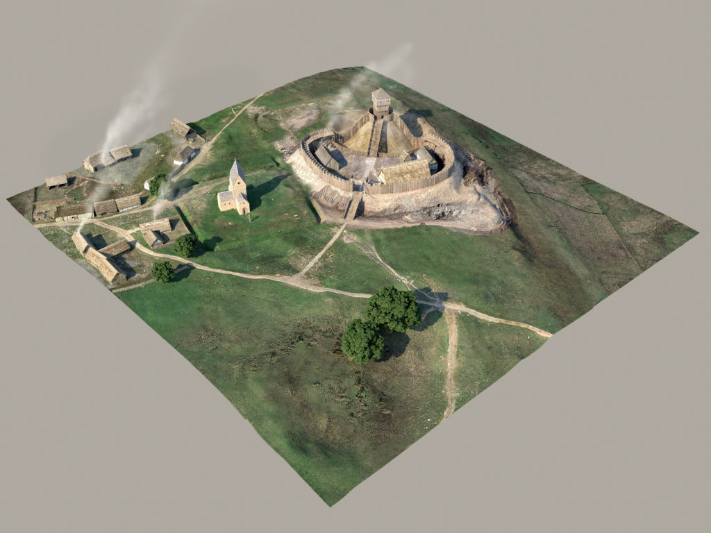
Laughton-en-le-Morthern as it might have been post Conquest (copyright Pighill Illustrations)

The second reconstruction depicts Laughton following the Conquest and after construction of the motte and bailey castle on the site of Earl Edwin’s hall. We cannot be sure when the castle was built, but it was most likely completed before the end of the eleventh century when Norman power in northern England was gradually being established. Laughton at this time was a contrasting picture of change and continuity, with some earlier parts of the elite complex maintained and others adapted or removed. Most obviously, the residential parts of the site were destroyed to construct the castle; excavation showed how the ditches surrounding Edwin’s hall were quickly infilled, and the posts supporting the fence were removed. Geophysics also confirms that the 9m-high motte at Laughton was built direct over the middle of the earlier arrangement, and extended over the western part of the enclosure. The church probably kept its original form in the eleventh century, and was only updated in the twelfth century after it came under the control of York Minster. While investment in the church continued through the twelfth century and later, occupation of the castle seems to have been very short-lived. Excavation identified no material from the later medieval period, and the motte and bailey was not enhanced with stone structures. At Laughton it seems that building of the castle was more important than its actual occupation; construction involved the destruction of Edwin’s residence and the raising of something new that demonstrated the establishment of Norman authority. Nearby Tickhill instead emerged as the most important secular centre in the region.  

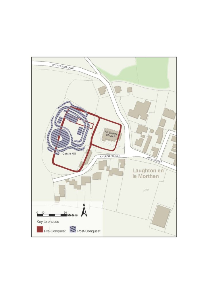
Phased Plan of Laughton en le Morthern

The phase plan outlines the core components of the two chronological periods recognised at Laughton. It makes clear how construction of the castle destroyed and disrupted the earlier elements of the high-status complex.

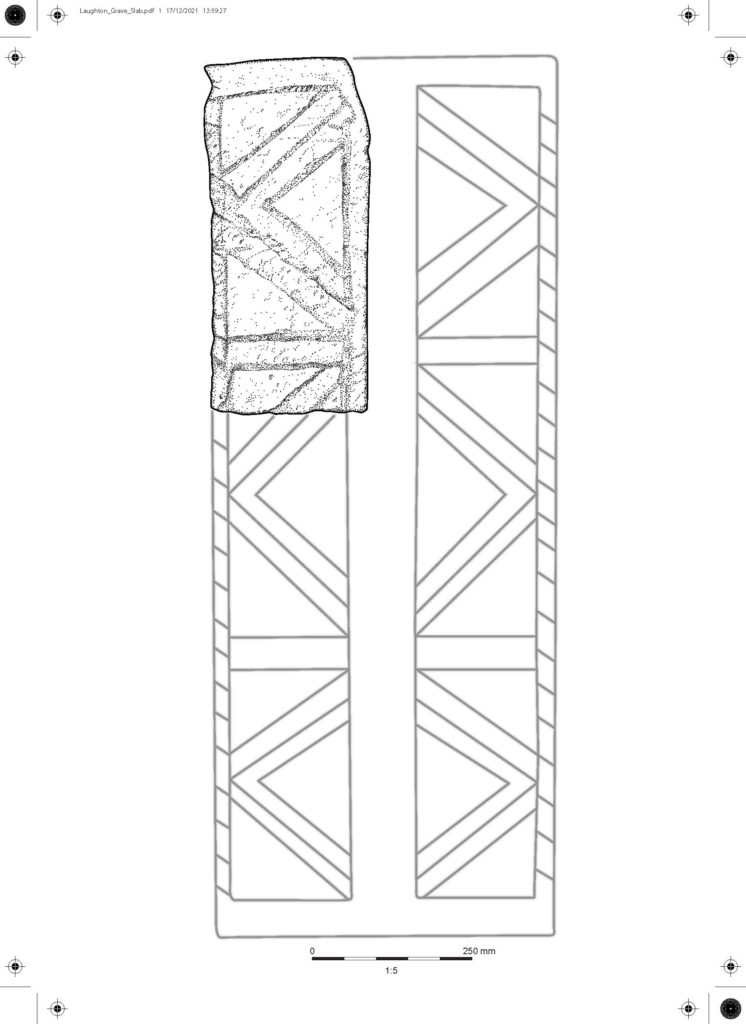
Early grave cover

The stone illustration represents about one sixth of an early grave cover with incised decoration, which was analysed by Professor David Stocker and Dr Paul Everson. This type of monument is well-recognised in eastern England and Yorkshire, and at Laughton the stone can be found built into the eastern wall of the chancel. It is a difficult stone to date precisely, but probably dates to the eleventh century and would originally have covered a burial either within or outside of the church.

Subscribe to our quarterly newsletter

All pictures and illustrations ndertaken by Peter and Rosalyn Lorimer of Pighill Archaeological Illustration. 

Where Power Lies: the archaeology of transforming elite centres in the landscape of medieval England c. AD 800-1200

Between 2018-2021, the Castle Studies Trust awarded Dr Duncan Wright three small grants to research the castle of Laughton-en-le-Morthen. The aim was to develop an innovative new research methodology to understand the near wholesale replacement of existing lords with incoming Norman tenants-in-chief physically showed itself post the Norman Conquest. Here Duncan explains what that has helped lead to.

In October 2021 the Arts and Humanities Research Council (AHRC) awarded Dr Duncan Wright (Newcastle University) an Early Career Research Grant of £200,000 in support of a new archaeological research project.

Subscribe to our quarterly newsletter

Entitled ‘Where Power Lies’, the project will undertake the first systematic examination of the physical evidence for elite centres in the landscape of medieval England between c. 800-1200AD. Many of these high-status places were developed as castles, and the research aims to identify the motivations behind choosing to build a castle at an existing lordly centre, when a site could equally be perpetuated as a manor house or else abandoned altogether.

The success of Duncan’s AHRC bid is partly thanks to the support of the Castle Studies Trust, who funded his research at Laughton en le Morthen (South Yorkshire) with three separate grant awards totalling almost £5000. The work at Laughton, which comprised geophysical and topographic survey, targeted excavation, and the commission of 3D reconstructions, not only helped reveal the complex history of the site but also acted as an important pilot and proof of concept for the new project. Indeed, Where Power Lies hopes to emulate the success of the research at Laughton, and will include some of the same survey techniques, but it will also scale up the focus to look at the national distribution of aristocratic centres with evidence for investment in both church and residential components.

Survey results of geophysical survey of Laughton-en-le-Morthen

After modelling the national picture, the Where Power Lies team will investigate a carefully selected sample of case study sites, which will be subject to topographic, geophysical, and standing building surveys. These investigations will allow us to reconstruct the biography of the case study locations in detail, and to explore how the character and expression of elite power invested in their residential and ecclesiastical complexes evolved over time. Working with the British Museum’s Portable Antiquities Scheme as an official project partner, the research will also produce a new profile of the artefacts of the aristocrats who built and occupied these sites. 

By undertaking this work, Where Power lies will shift the focus beyond the relatively small corpus of excavated aristocratic sites of the period which continue to form the basis of our understanding. Instead, by embracing a range of digital technologies and non-intrusive survey methods, the projectwill create valuable new datasets at a number of scales. By generating this new information, the team will demonstrate how the transformation of power centres occurred on the ground, revealing whether castles integrated earlier components into remodelled layouts, or whether they caused greater destruction and a more fundamental schism with the past.

Excavation at Laughton showing remains of a ditch that ran next to a possible entrance way to the Saxon lordly centre.

The team will be led by Duncan as Principal Investigator, who will be accompanied by Professor Oliver Creighton (Exeter University) as Co-Investigator, and a Research Associate who will join the team for the duration of the project. Duncan would like to take this opportunity to thank the Castle Studies Trust for their generous support of his research at Laughton en le Morthen, which strengthened the AHRC bid significantly. He hopes the results of Where Power Lies will prove of interest to everyone associated with the Trust.

Subscribe to our quarterly newsletter

You can read more about the Laughton-en-le-Morthen project here: https://castlestudiestrust.org/blog/2020/08/25/landscapes-of-lordship-searching-for-laughtons-anglo-saxon-elite/

Landscapes of Lordship: Searching for Laughton’s Anglo Saxon elite

In an article that first appeared in Current Archaeology issue 360 (March 2020) Duncan Wright and Samuel Bromage discuss how the two research projects which they undertook at Laughton-en-le Morthen, with CST’s funds, has shown how the siting of castles was influenced by the older patterns of high-status activity in South Yorkshire.

Castles are perhaps the most iconic buildings of the medieval period, which for many are synonymous with feudal warfare and conflict. In spite of this popular perception, the idea that castles were mainly built for military purposes has been questioned for some time, and archaeologists now point to a number of reasons for their construction. In England, even fortifications thrown up in the wake of the Norman invasion are no longer seen purely as tools of martial conquest.

Subscribe to our quarterly newsletter

Instead, it is increasingly clear that earlier patterns of aristocratic life were important, and that the manorial residences of the Anglo-Saxon nobility in particular were chosen for the siting of early castles. Such targeting should not come as a surprise—the Conquest is understood as an exercise in elite regime change, which saw the near wholesale replacement of existing lords with incoming Norman tenants-in-chief. Yet, the way in which this transformation physically manifested is poorly understood. Few relevant sites have been subject to excavation, and where archaeological intervention has taken place it has often been piecemeal or of limited size. The Landscapes of Lordship project seeks to improve this picture, and recent work at Laughton-en-le-Morthen in South Yorkshire, funded by The Castle Studies Trust, offers a case study of archaeology’s potential to reveal more about this fundamental aspect of the Conquest.  

Anglo Saxon Elements

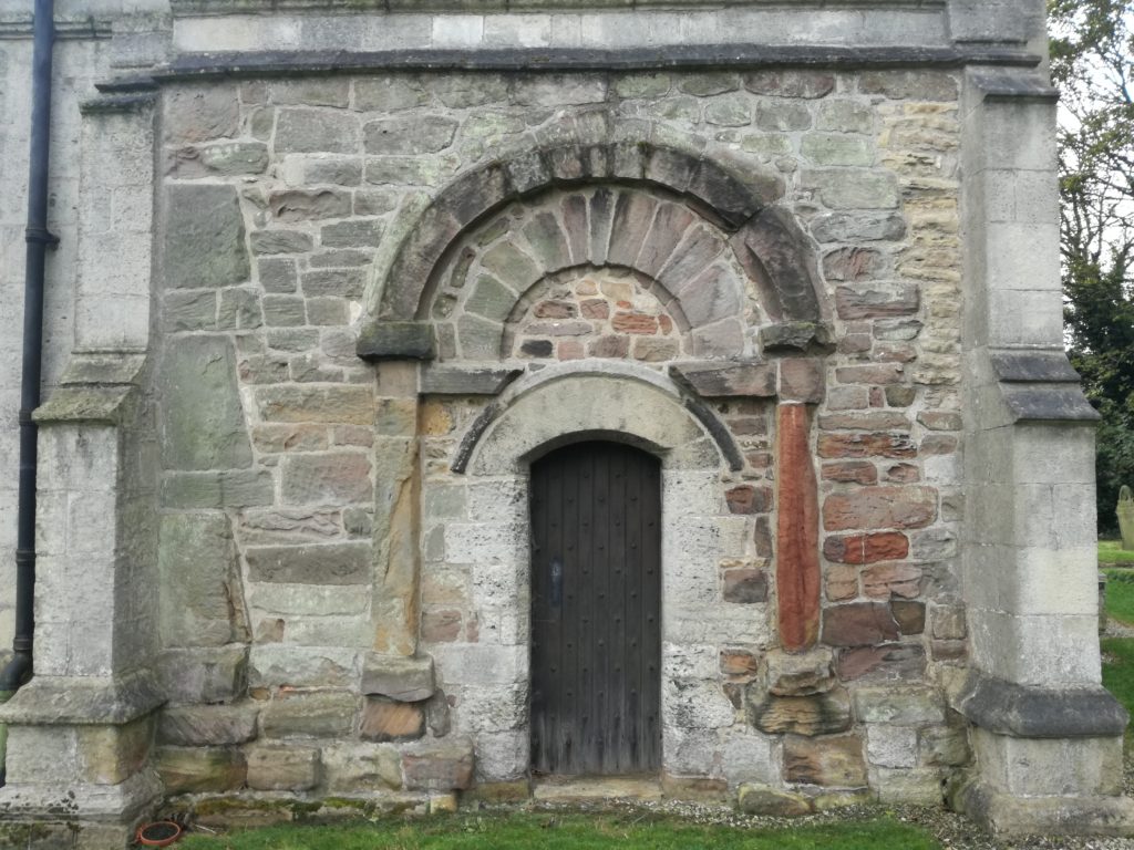
Laughton today is a modestly-sized village in the Rotherham district, perched high on a limestone ridge which offers impressive views, especially westwards towards the Peak District. The historic core of Laughton is focussed around the parish church of All Saints and the adjacent remains of a motte and bailey castle. A visit to the former provides the first hints of Laughton’s early history; an elaborate 10th or 11th-century doorway is located in the church’s north wall, and a similarly-dated grave slab is built into the eastern exterior of the chancel. Inside the church, a triangular-headed opening, a distinctive pre-Conquest form, covers a piscina—a shallow basin used to wash communion vessels. These pieces of stonework indicate the presence of an earlier building at Laughton, decorative fragments of which have been reused in later phases of construction. It is almost certain that this structure too was a church, as stone was almost never used for secular building in early medieval England.

Elaborate C10 or C11 doorway at the parish church.

In 2005 archaeological excavations due east of All Saints also found evidence of pre-Conquest activity, in the form of a circular grain-drying kiln. A significant assemblage of 10th—11th-century pottery was recovered from the excavations, highly unusual finds given that South Yorkshire was largely aceramic at this time. Documentary sources help to provide some context for the excavated material and that found in the church. The Domesday Book records that, prior to the Conquest, Earl Edwin of Mercia had an ‘aula’ or hall at Laughton. Edwin was a leading noble, but also a leading protagonist against the Norman regime. Brother-in-law of Harold Godwinson, Edwin, together with his younger brother Morcar, raised an unsuccessful rebellion against William the Conqueror after the Battle of Hastings. Dispossessed of his extensive lands, Edwin was ambushed and killed three years later.

Subscribe to our quarterly newsletter

Exactly where Earl Edwin’s hall was located in Laughton has long been a mystery, with the popular belief that it lies under the earthworks of the castle. The Landscapes of Lordship project set out to test this idea, firstly through a scheme of topographic and geophysical survey. A detailed topographic model of the castle and the surrounding parts of the village was made using a drone, and earth resistance survey provided a plan of buried features from the bailey and an area of open ground to the south. The results from the combined techniques exceeded even the expectations of the team, identifying a host of important archaeological features. In the bailey, geophysics picked up a number of anomalies which were also detectable as a low earthwork—the size and shape of which is consistent with buildings, and probably represent the centre of Earl Edwin’s hall complex. To the south of the bailey, ditches seemed to form two sides of an enclosure, one side of which was interrupted by the apparent construction of the motte. 

Survey results from the first year of research funded by the CST

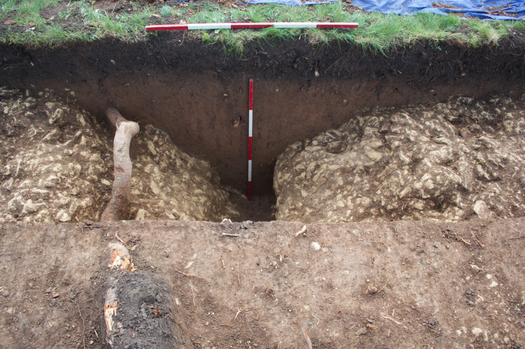
Although the project team were confident that these features were related to Edwin’s estate centre, it was decided that a targeted excavation would be best to confirm this conclusion. A second phase of work, also supported by the Castle Studies Trust, was instigated to ground truth some of these findings, with two trial trenches dug over the ditches to the south of the castle. Excavations uncovered a V-profile ditch with a distinctive narrow base, which would have served to locate a wooden palisade, supporting the premise that this was indeed Edwin’s compound. No datable material was recovered from the ditch but the material inside was notably clean and consistent, indicating that infilling had occurred in a short window or perhaps as a single event. Beyond the enclosed area, another more substantial ditch was found—this feature seemed to project southward from the castle and may be part of an enclosure surround the village, the form of which is preserved in the historic street plan.

Hunting the Hall

The Landscape of Lordship investigations, then, support the idea that Laughton was indeed the site of Earl Edwin’s ‘aula’ and other buildings, which were surrounded on all sides by a ditched enclosure enhanced with a palisade. Edwin and his entourage would have had exclusive use of the elaborate stone church, which topographic evidence demonstrates lay within its own small rectilinear churchyard. Outside of this high-status enclave, the find of a drying kiln suggests that Laughton acted as a point for the collection and processing of agricultural produce, potentially from an extensive area. Indeed, Laughton was the centre of a large territory incorporating several later parishes, the component settlements of which are now most discernible by their ‘Morthen’ place-names.

Ditch found during the excavation

At some stage, Laughton’s lordly compound was radically transformed—the palisade fence was taken down and the ditches rapidly filled in; in their place was constructed a massive earthwork motte across the western edge of the enclosure. A kidney-shaped bailey incorporated the most important buildings including the hall, but it is impossible to tell without more investigation whether these were maintained or replaced with new structures. Probably around the same time the settlement to the east of castle and church was surrounded by a rectilinear enclosure, effectively forming an extensive outer bailey of the castle. Such arrangements are not uncommon in England but perhaps the most famous is at Pleshey in Essex, where a semi-circular bank and ditch encircles the village to the north of a motte and bailey castle.

While the nature of the archaeological evidence does not provide absolute dates, the most compelling context for the apparently rapid changes visible at Laughton is the protracted conquest and subduing of northern England in the years following the Norman invasion. Once annexed, Laughton and its estate were quickly subsumed into a large territory given to Roger de Busli who established a centre at Tickhill where a sizeable castle was erected. Given that the main seat of authority lay at Tickhill, it is unusual that Laughton too was furnished with a castle and that it continued to act as an administrative focus at least temporarily. The explanation for Laughton’s perpetuated importance undoubtedly lies in its pre-Conquest past. As an important residence of Earl Edwin, a foremost member of the Anglo-Saxon elite, Laughton’s appropriation was clearly an attempt to assume a recognised place of power. Yet, the drastic overhaul of the site also embodies a conspicuous act of conquest, physically destroying the complex of a central opponent to Norman rule. It is possible that the processes of castle construction in itself was its raison d’être, acting as a material ‘seal’ of new authority in the eleventh-century landscape. Indeed, this may help explain the paucity of medieval finds from the excavation—the castle itself having experienced little or no use, as its primary purpose had already been met by its very building.

The work by the Landscapes of Lordship project has provided a unique insight into Laughton’s past, showing the importance of older patterns of high-status activity in shaping the process of castle siting in South Yorkshire. The project team now intend to employ this approach to further sites and regions, allowing a new archaeology of elite residence, conquest, and regime change to be written.

Subscribe to our quarterly newsletter

Duncan W Wright was Senior Lecturer and Programme Leader of Archaeology and Heritage at Bishop Grosseteste University, Lincoln during the project and has recently been appointed Lecturer in Medieval Archaeology at Newcastle University

Samuel Bromage is a PhD researcher at the University of Sheffield. His doctoral thesis investigates the consequences of the Dissolution for urban development in Yorkshire.

Current Archaeology can be found here: https://www.archaeology.co.uk/

Reconstructing Ruthin Castle

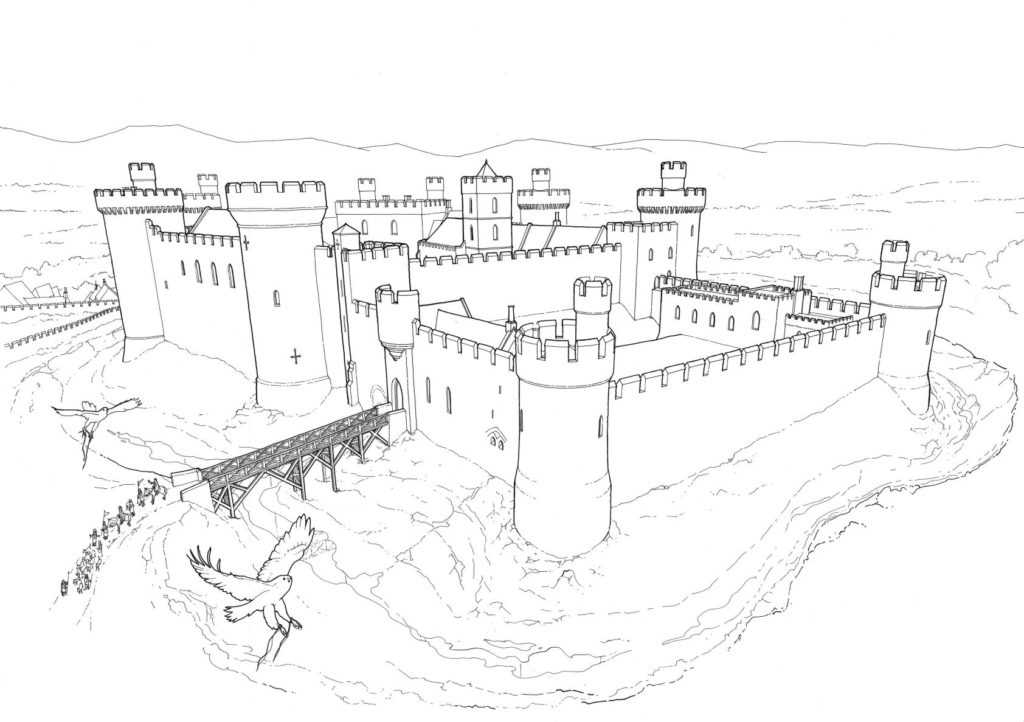
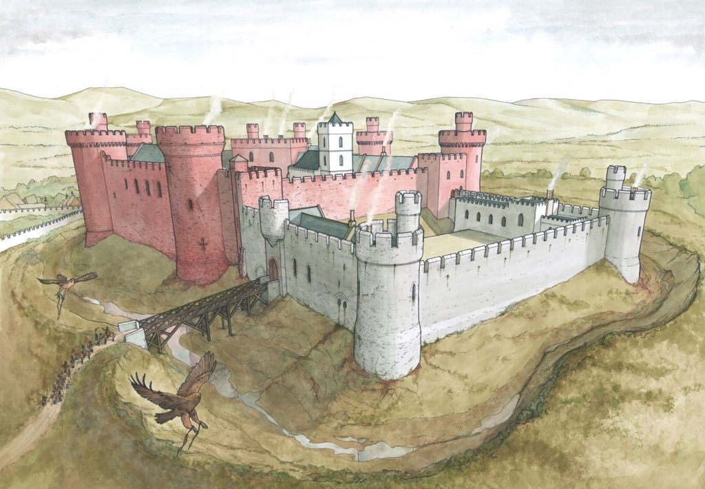
The commission to carry out a reconstruction drawing of Ruthin Castle came after several years of visits and informal discussions with Will Davies and others, all anxious to bring the castle to greater prominence. Once the Ruthin Castle Conservation Trust had been set up in 2016 to arrest the deterioration of the castle ruins, it became imperative that better researched material, texts and drawings be produced to raise awareness of the castle and the critical condition of the ruins. The Trust accordingly commissioned a reconstruction drawing with grant aid from Castle Studies Trust, Castle Studies Group, and the Cambrian Archaeological Association.

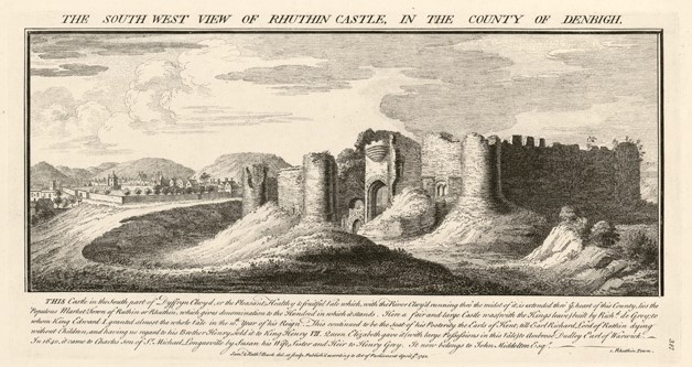
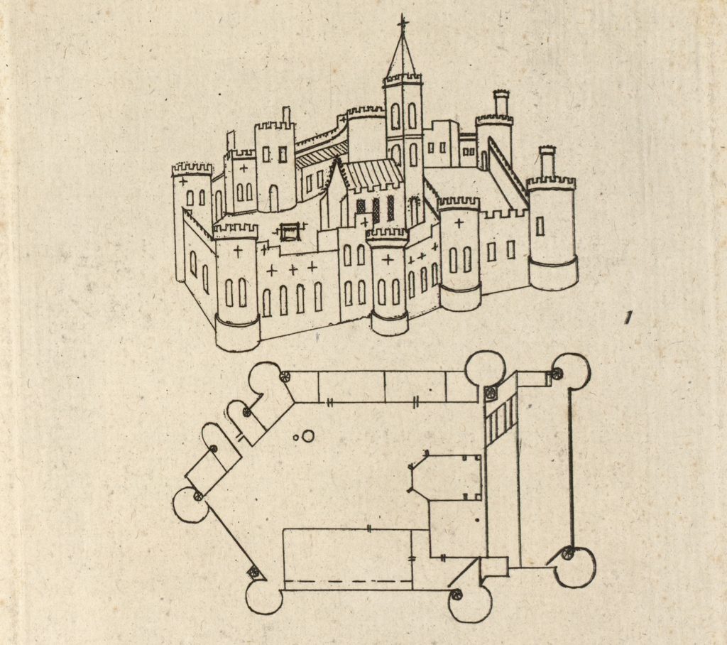
The available documentary sources were scarce. Principal among them was the somewhat hesitant plan drawn by Randle Holme in the 17th century, complete with alterations and amendments, accompanied by two very similar versions of a perspective view, and the inevitable Buck from a century later.

An engraving by the Buck brothers in 1742 from the collection of the National Library of Wales.

Rick Turner identified a detail in the background of a 17th-century picture of “Orpheus Charming the Animals” housed at Chirk Castle, which he believed represented Ruthin. After several attempts at getting a good look at it, some shots were obtained for me by helpful member of National Trust staff. All this was greatly enhanced by a reasonably good topographical survey of the hotel and gardens prepared some years ago.

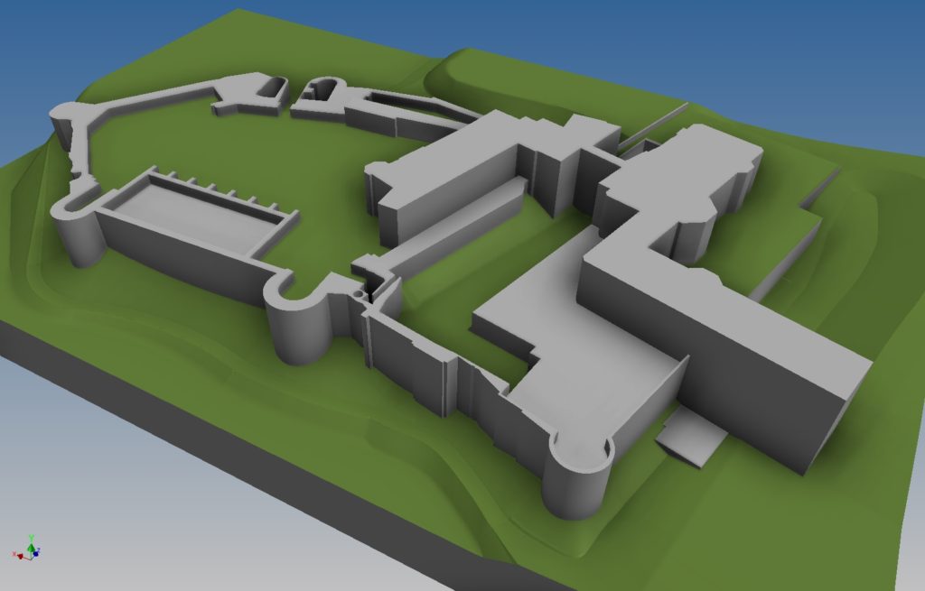
I began by creating a very rough block model of the remains of the castle with the hotel in place, to better identify the elements missing completely and those in doubt, with a view to possibly carrying out some minor excavations to resolve some of these issues. Unfortunately this was not to happen within our timescale, so such revelations still await us in the future.

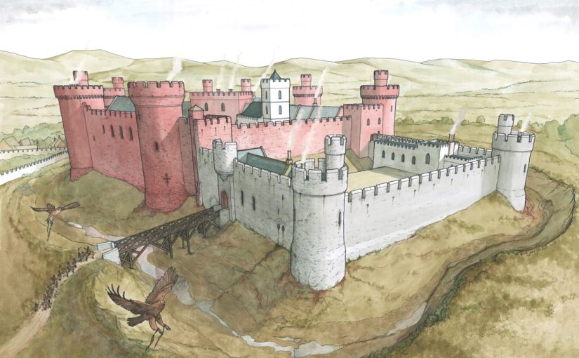
The need to produce a useful image for the Trust rather than a long drawn out programme of investigation resulted in a quick agreement of the general viewpoint, displaying the most dramatic surviving parts of the castle in a completed medieval context, but in such a way that minimised the missing pieces. The result was essentially the Buck and Holm views, but altering some details contained in the latter which did not agree with the surviving remains. A lower vantage point was chosen to conceal the missing details of the buildings in the background.

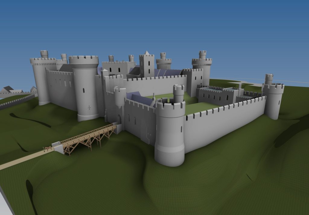
The model was subtly orientated to provide the optimum view, turned into a line drawing, and then the final colour version was produced.

Ironically, it was at this point that the most heated discussion began, regarding the colour of the walls. The present remains of the outer ward are predominantly of a deep red sandstone, with the inner ward of light grey limestone (with some red quoins). The implications of this were far reaching, but for the purposes of the drawing the issue was simply to render or not to render, and if rendered, what colour? The castle is described in some documentary sources as “Castell Coch”, hence red was taken to be the main colour, so perhaps the inner grey ward was rendered red. In the end the consensus was not to render at all, but to expose the masonry as it presently appears, with the red colour of the outer bailey dominant, giving rise to the name. Even then there was some dissent over the strength of the colour of the natural red sandstone in the final image, but “Castell Coch” won out.

Reconstruction drawing of Ruthin Castle from the south-west as it may have appeared in the late medieval period. 
Artist: Chris Jones-Jenkins. Copyright: Ruthin Castle Conservation Trust.

The original painting has now been elegantly framed and is hanging in the foyer of the Castle Hotel, available for all to see. It is hoped that the image will go on to stimulate further discussion in the years to come and generate interest in and publicising the work of the Trust in promoting this historic asset.


To hear more about our work please subscribe to our newsletter.

[mc4wp_form]

Pembroke Castle 2018 Excavations – the results

Parchmarks, and geophysical survey funded by the Castle Studies Trust in 2016, show that a large building once occupied the outer ward of Pembroke Castle. In outline, it seemed to be a free-standing, winged ‘mansion-house’, of a kind broadly dateable to the fifteenth century – making it a compelling candidate for the location of King Henry VII’s birth in 1457. But further investigation was needed to confirm its form and date.

Subscribe to our quarterly newsletter

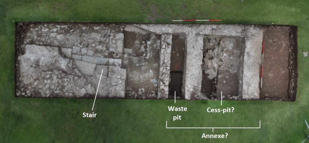
This began in 2018, with an archaeological evaluation that again was funded by the Castle Studies Trust, and carried out by Dyfed Archaeological Trust with the assistance of dedicated volunteers, and the support of Pembroke Castle Trust and staff. In essence, this was a preliminary scoping exercise: two trial trenches were excavated, representing around 20% of the suspected area of the building. And, as Pembroke Castle is a Scheduled Ancient Monument, the consent needed to carry out the work specified that the bulk of the stratified deposits had to be left in situ. Project objectives had, therefore, to be kept within realistic boundaries, namely to establish the condition, character and extent of the building – and, if possible, its date.

Pembroke Excavations Trench 1

Despite these limitations, we feel that the evidence uncovered does not seriously challenge our interpretation of the building as a winged house. It was shown to have had stone walls, one of which housed a stairway suggesting it had at least one upper floor, and an annexe containing a pit for kitchen waste alongside a possible cess-pit. The dating evidence was not precise, but does not rule out a late-medieval date, while the stair was of a helical form seen in fifteenth-century buildings in Pembrokeshire. Which means that we could still be looking at Henry VII’s birthplace.

Subscribe to our quarterly newsletter

And the trenches may confirm our suspicions about the antiquity of the castle site. It has long been suggested that the medieval remains overlie an earlier, Iron Age fort, which may have continued to be used throughout the Roman period – and perhaps even right up until the Norman Conquest. The waste deposits seemed to slump into an earlier pit or trench, and contained Roman pottery and charcoal yielding a Roman-period radiocarbon date. Both perhaps came from disturbance of deposits within the earlier feature.

Future Plans

We feel that further excavation is the only way to fully unlock the secrets of this intriguing building, as the best clues to its date, status and function will probably be found in its form and plan. This information may in fact prove even more useful than the dating evidence provided by finds and radiocarbon samples. This is because the area around the building was heavily disturbed by excavation in the 1930s, following which soil, containing pottery, seems to have been brought in from outside the castle for landscaping. In addition, the scheduled monument consent limits the excavation of the undisturbed deposits.

Further investigations will hopefully begin next year. Another trench in the area of the suspected cess-pit may confirm whether or not it occupies a winged ‘annexe’ housing a suspected second stairway, while a trench in the suggested kitchen wing may show whether it did contain any ovens or fireplaces. It is hoped that, eventually, the entire ground-plan of the building will be revealed. We may then also see how it related to other deposits and features in the outer ward. Excavation can be a cautionary tale, which advises against letting prior assumptions govern interpretation of the results. It is entirely possible that a very different storyline from the one suggested above may yet emerge.

Neil Ludlow – consulting archaeologist on the excavation

To read the full report you can download it here: https://www.castlestudiestrust.org/Pembroke-Castle-2018.html

subscribe to our quarterly newsletter

Baffling Bolingbroke: understanding Henry IV’s home

In rural Lincolnshire, nearly 30 miles east of Lincoln, stand the remains of a castle once held by royalty. The remaining walls and towers of Bolingbroke Castle are still 3m tall in some parts, and you can make out its distinctive hexagonal shape. The buildings that once crowded together inside the castle have long-since disappeared.

Bolingbroke Castle was founded in the 1220s by Ranulf de Blundeville, Earl of Chester and Lincoln and through marriage it ended up in the ownership of the House of Lancaster. John of Gaunt, Duke of Lancaster, lived here in the 1360s and the castle gave its name to his son Henry Bolingbroke, later crowned King Henry IV, who was born here in 1367. The history of the site is reasonably well documented, especially compared to castles not owned by the Crown, but there remain unanswered questions about its origins and development.

In 2018 we gave Heritage Lincolnshire a grant to delve deeper. They would carry out a geophysical survey to establish if there are buried remains immediately south of the castle and on Dewy Hill, which might be the site of an earlier castle, built before the stone one still visible at Bolingbroke.

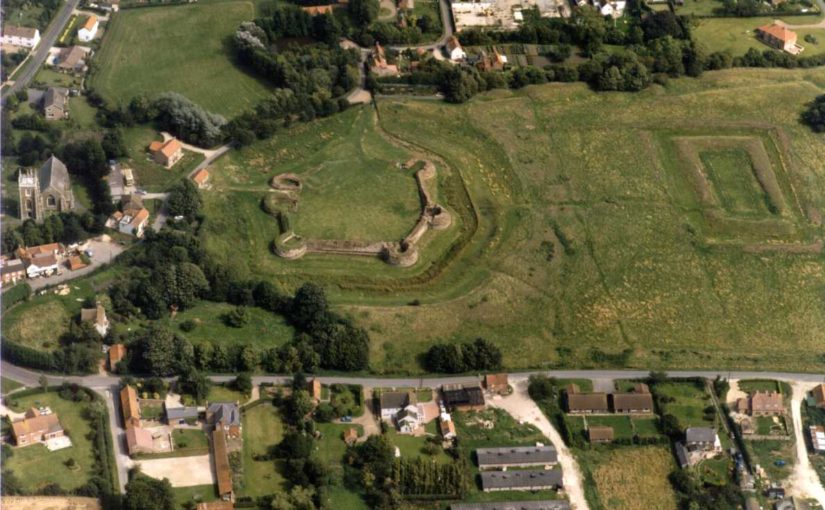
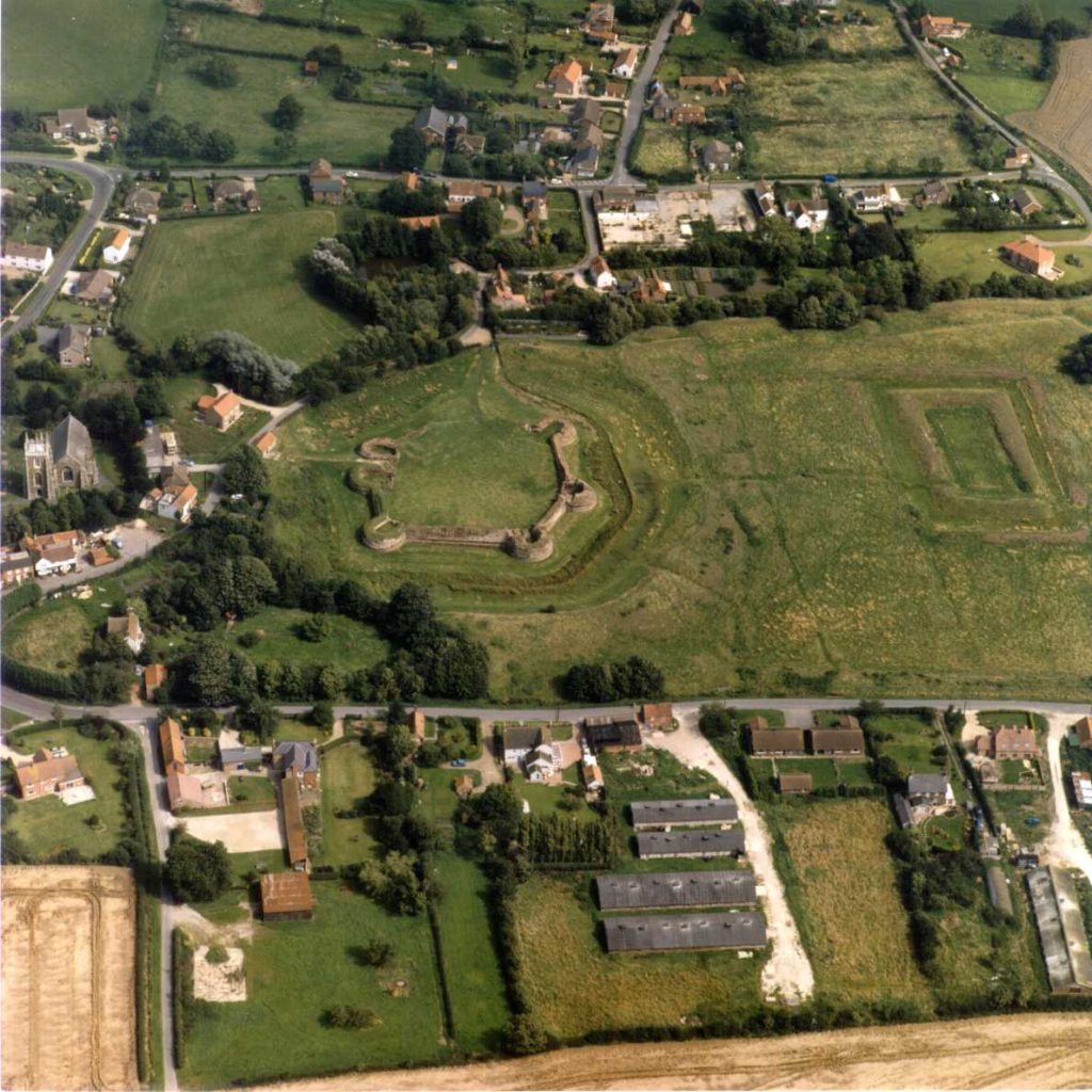
Aerial photo of a green field surrounded by houses. At one end of the field stand the remains of a hexagonal castle.
Bolingbroke Castle on the left and the rectangular ‘Rout Yard’ on the right. Courtesy of Heritage Lincolnshire.

The plan was to use ‘magnetometry’. It works by measuring how magnetic the soil is and then plotting the results on a map. It allows you cover a large area quickly, and over the course of two days the Heritage Lincolnshire team surveyed more than five hectares (about five times the size of Trafalgar Square).

There is some natural variation in the soil, but typically human activity such as cooking hearths or stone walls have a different magnetic signature to the soil around them as they are made from different materials. Magnetometry can also be used to find filled-in ditches as the fill might contain traces of human occupation.

The first stage was to survey Dewy Hill, sitting 400m north-west of Bolingbroke Castle. It was excavated in the 1960s, and a digital survey of the terrain suggests a rectangular feature still survives. We hoped the geophysical survey would show how extensive the buried remains are, and the shape and size might give us an idea of what it is. Essentially, was it a castle or some other type of important place? There was a slight hitch…

But Heritage Lincolnshire did eventually get to take their magnetic gradiometer for a spin! Next, they surveyed the area south of the castle as it might contain an extension of the castle which has since been dismantled. Are there traces of this possible enclosure, or was there perhaps a garden here? In the later Middle Ages it was especially popular to shape the landscape around a castle. Right in the middle of this area is a rectangular piece of ground called the ‘Rout Yard’, but it’s unclear when it was created so the survey aimed to establish how this area relates to the castle.

Understanding the results takes a trained eye, and Heritage Lincolnshire have a highly skilled team of experts. They were able to find a few anomalies, but they either appear to be modern (there may be a concrete slab on Dewy Hill) or natural geological features.

The point of an exploratory project is to find out what lies beneath. Oddly, we expected something to be at Dewy Hill since earlier excavations suggested there might be some activity. The search for a possible bailey suggests that perhaps one did not exist or if it did it may have been insubstantial. That would mean the ruins we see today may represent the extent of the castle at its peak. Interestingly the fashion for having gardens might have passed Bolingbroke by. It was an important place, so may have begun to fall out of use by the time gardens became a common part of high-status medieval landscapes.

Despite the siege of 1643, the survey did not uncover ‘siegeworks’ which would have been built by the Parliamentarians. This might be because the siege was relatively short.

As a result of this work, we know more about how the surroundings of Bolingbroke Castle. Other types of geophysical survey may pick up different pieces of evidence, helping build a fuller picture of the area. Surveys like this are an important tool to understand sites, and Heritage Lincolnshire’s work will inform any future work at the castle.

Thank you to the owners, the Duchy of Lancaster, for allowing us to carry out the survey, to English Heritage who are guardians of the site, and to the volunteers from the local community who helped with the fieldwork. Projects like this really do take a village.

A full report has been prepared by Heritage Lincolnshire.

Going in search of Keith Marischal

In the later Middle Ages, the Keith family were some of the most important people in Scotland. Sir Robert Keith was made marischal of Scotland in 1293, a title that descended through his heirs. As marishal, Sir Robert and his successors were could hold courts during wartime and were responsible for maintaining order within the Scottish parliament. The castle at Keith Marischal, half a day’s journey from Edinburgh, was the family’s ancestral home.

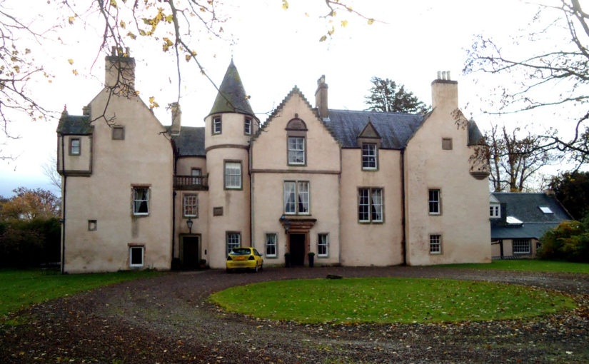
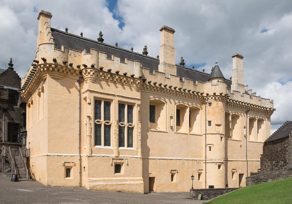
For a family which was amongst Scotland’s richest in the 16th century, their seat was an important place which would have embodied their power and prestige. The great hall, the social heart of the castle, vied with royal palaces in its size. William Keith, 7th Earl Marischal was forced to sell Keith Marishcal during the Civil Wars, and, despite being an important piece of Scottish history, the castle was gradually demolished. Part of the castle survives and was incorporated into the later house built on the site, but much of Keith Marischal has vanished.

Stirling Castle’s great hall. Photo by ‘DeFacto’, licensed CC-BY-SA 4.0.

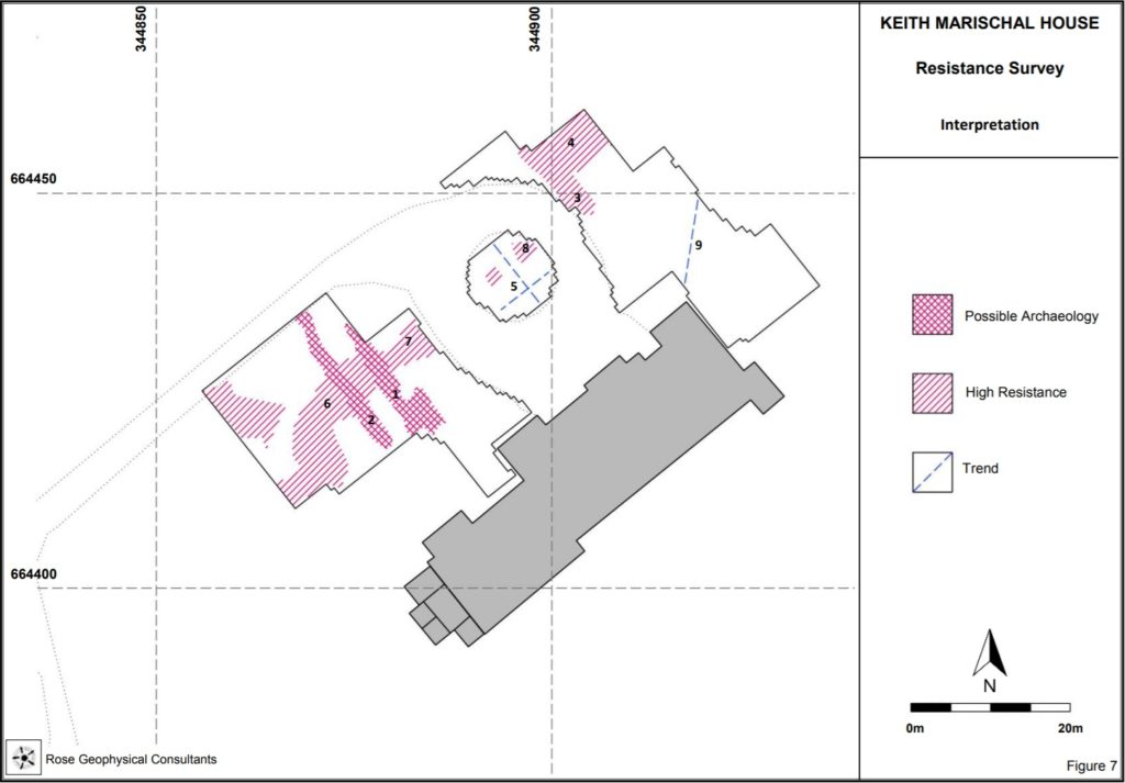
In 2017, Miles Kerr-Peterson suggested carrying out a geophysical survey to look for buried remains just north of where the house currently stands. He successfully applied to the Castle Studies Trust for funding, and in May 2018 he and Rose Geophysical Consultants visited Keith Marischal to search for the evidence in an area of 2 hectares.

Two methods were used: resistivity and ground penetrating radar (GPR). As different materials conduct electricity differently, testing the electrical resistance of the ground can be used to find features such as walls (high resistance as there is little water) or ditches (low resistance as ditches tend to hold water), and is effective to a depth of about 0.75m. GPR works by sending electromagnetic pulses into the ground and tracking how they are reflected. Part of the area north of the house is a carpark, which makes survey resistivity ineffective, but GPR can still be used.

Deciphering a geophysical survey takes a trained eye. The resistivity survey found several features, and working out what they are has been an interesting challenge. There are two features running in a mostly straight line perpendicular to the current house at the west end of the survey. The longer of the pair could be a drain, but it’s uncertain. And what are the features at the north end? The feature runs beyond the edge of the survey, so we don’t know the full shape and size of it. With trees nearby it could even be part of a root system, but the straight lines suggest it could be man-made and could be part of the lost castle.

GPR allows us to peer deeper, and to work out a rough stratigraphy of features. The survey was able to corroborate some of the anomalies found with resistivity. The pair of parallel features at the west end are visible, but the one on the right runs deeper. The fact it’s so narrow suggests it might be a drain. The GPR also found an anomaly at the north end of the survey area, lining up with the one found using resistivity. It was visible some 0.38-0.63m deep, which suggests it might be artificial rather than natural.

The results of the survey are certainly interesting. We didn’t find the extent of the lost Keith Marischal Castle, but most discoveries don’t happen overnight. Geophysics is an excellent way to identify areas of interest ahead of excavation. Without excavation, we can’t be sure about the interpretation of these features. If the anomaly at the north end of the survey is part of the lost castle, we don’t have a way of dating it without breaking out a trowel.

The survey was a vital step in the understanding Keith Marischal. Thanks to Miles and Rose Geophysical Consulting, any future excavations will know where to look. Keith Marischal has an exciting future, and the Castle Studies Trust are proud to be able to have played our part in supporting the work.

Dr Miles Kerr-Peterson is an affiliate in Scottish History at the University of Glasgow. His new book, A Protestant Lord in James VI’s Scotland George Keith, Fifth Earl Marischal, touches on the Keiths and is out now.

The art of the reconstruction

When walking round ruined castles, it can be difficult to picture how they once were. There may be missing floors, the roofs aren’t the same, and entire buildings might have vanished. Even when a structure appears to survive intact, we are usually missing the interior – how it was decorated, the furniture, even how light changed throughout the day.

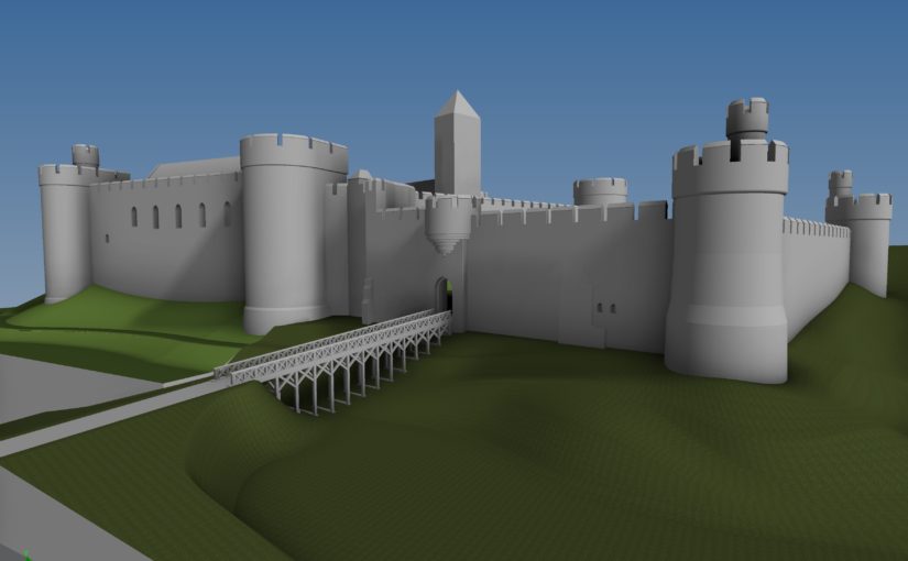
Reconstructions are a wonderful tool for bringing castles back to life. This year, the Castle Studies Trust is funding one such reconstruction. Chris Jones-Jenkins is helping us understand how Ruthin Castle would have looked. You might recognise his name from 2015, when he worked on one of our very first projects, the digital model of Holt Castle, or from his various work with Cadw and English Heritage.

We caught up with Chris to learn a bit about what goes into these illustrations and how he got into reconstructions. Older illustrations, like those done by Alan Sorrell decades ago, were done by hand while a lot of reconstructions today are done on a computer. Chris has experience of both, and they are very different processes. When working by hand, you need to start off by choosing your viewpoint and deciding what it is you’re going to show. With a digital reconstruction, you have the option to change the position of where you’re looking from. Chris reconstructs everything in the image and the viewpoint might be the last thing to be settled. With Holt for example, if that had been reconstructed 20 years ago the viewpoint would have been one of the first things decided – what to show, what to discreetly tuck away, and how to balance highlighting everything you want. Instead, as Chris created the whole thing digitally it was possible to use the model to create a flythrough video.

A plan of Ruthin Castle from Thomas Pennant’s 1781 edition of ‘A Tour of Wales’, from the collection of the National Library of Wales. Image in the public domain.

A wealth of information goes into reconstructions. For Holt and Ruthin, any standing remains are taken into account and modelled, while historical evidence such as paintings or documents are used to fill in the gaps where parts of the structure are missing. Chris trained as an architect and early in his career so has an eye for how buildings are put together, complimenting his skill as an artist and years of experience with historic buildings. Will Davies and Sian Rees have been helping with the research into Ruthin Castle and how it appeared, giving Chris the best information possible to work from. There was a survey of the curtain wall, but done to the wrong scale, which kept the team on their toes.

Working with some kinds of source material you get a feel for how useful and accurate it is. For instance, in the 17th century Randle Holme made some useful plans of Holt Castle in pen and ink. He also created a view of Ruthin Castle, but for some reason his work here wasn’t as reliable. The test is that the parts of the castle that still survive weren’t well illustrated by Holme, so his work needs to be used carefully.

A lot of time and effort goes into reconstructions. It can take over six months from start to finish, with drafting, redrafting, tinkering with details, and pausing to research a particular feature or issue. Over this time, the reconstruction grows from a plain model to a textured, colourful building. Reconstructions have an element of educated guesswork, but attention to detail is important. If you misstep and include something not appropriate for the period there are eagle-eyed heritage lovers who spot this kind of thing! New information is being uncovered about Ruthin, which directly informs Chris’ work. But there are some questions, like the forms of buildings, which are only likely to be answered by excavation.

Chris has been working on reconstructions since the 1980s, and aside from the change in technology has noticed an interesting trend. Previously, there was often emphasis on showing the structure while more recently the organisations commissions reconstructions want to populate these buildings, showing daily life inside.

Talking to Chris, one thing that cropped up is that reconstruction artists don’t often get to hear what the public think about their work which is a real shame as it can make a world of difference to a site. So when going round a historic site, if you see a reconstruction that captures your imagination or helps you understand the place better, pass on that positive feedback.

The image at the top of this page shows the a work-in-progress version of the reconstruction. Subscribe to our quarterly newsletter so you don’t miss news about the finished reconstruction and our other projects.

Trial trenching at Pembroke Castle

In 2016, geophysical survey by Neil Ludlow and Dyfed Archaeological Trust (DAT) revealed the remains of long-vanished buildings, and other features, at Pembroke Castle. This work would not have been possible without the Castle Studies Trust, which funded the entire project.

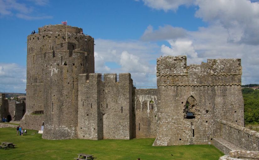
Pembroke is famous for its large round keep, built by earl William Marshal, and a complex of other stone buildings is preserved in the inner ward. But the large, outer ward has been an empty space since at least the eighteenth century. Nevertheless, very dry summers had revealed ‘parchmarks’ here, showing that ruined walls lay just below the surface. These showed up particularly well during 2013 when they were photographed by Toby Driver of the Royal Commission on Ancient and Historical Monuments (Wales), and were published by Toby, with Neil Ludlow, in Archaeology in Wales.

This was the genesis of the current programme of investigation at the castle. The geophysics that followed used a combination of magnetometry, resistivity and Ground Penetrating Radar, to confirm the parchmark evidence and also show that a number of further buildings, and other features, formerly lay in the outer ward. The most exciting of these is a large building which may represent a free-standing, double-winged mansion-house from the late Middle Ages. If so, it would be quite exceptional: grand buildings of this particular kind are unusual in castles, and particularly in outer wards which are normally thought to have contained the more lowly buildings associated with everyday castle life.  It means that the outer ward, at Pembroke, may have been ‘gentrified’ – at least in the fifteenth century. This may make sense of historical accounts which place the birth of the future king Henry VII in the outer ward: it may have occurred within this very building.

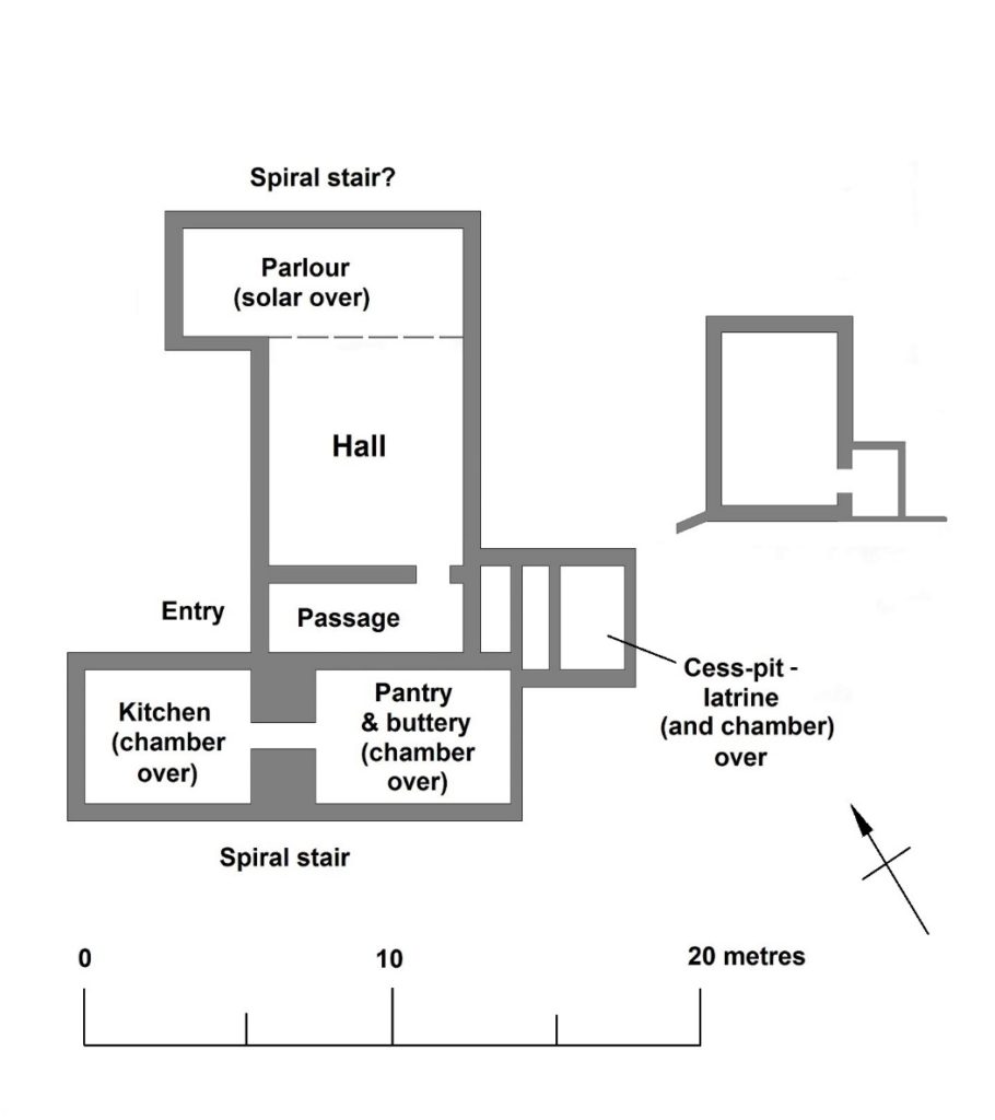
What the geophysics and parchmarks seem to show is a large, central hall, flanked by two wings. If the building was anything like others of its kind, one wing will have contained the kitchen and ‘services’ – the buttery and pantry – while the other represented more private accommodation. The outer ward was partly excavated in the 1930s – sadly, without record – but a photograph shows a large, stone-lined pit, apparently leading off the hall, which may be the cess-pit mentioned in an account from the period. A square annexe showed up here in the survey work.

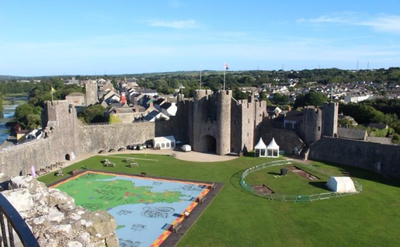
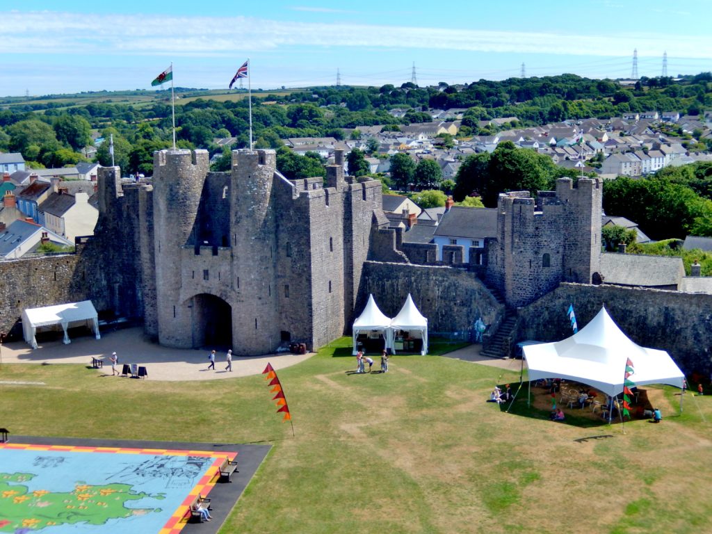
Just inside the castle beside Pembroke’s main gate are parchmarks (where the white tents are). They show the position of a late medieval hall. ©Neil Ludlow

While the results showed what can be achieved through geophysics – and generous grant-aid – their interpretation is, at the moment, still speculation. Only educated guesses can be made about the exact form, date and function of the building. But it has the potential to make a big contribution to the study of castles, and late medieval history, at a national level. So Neil got together with James Meek of DAT to decide how best to get answers to these questions. Only excavation could really provide the answers but, given the sensitivity of the site, which is a Scheduled Ancient Monument, and the importance of the building, minimum intervention, for now, was the preferred approach – a small excavation, primarily just to see how much has survived. This was agreed by Cadw, who granted permission for the hand-excavation of two trial trenches, one across the hall and possible cess-pit, the other across one of the wings. Overburden will be removed, and hopefully the remains of the medieval walls, and any floor-surfaces, will be revealed. It is not intended to go down any further – or at least, not in the present project which will effectively be an evaluation.

We also don’t know how much was removed during the 1930s excavation. While we know there must still be walling, as it shows up in the geophysics and parchmarks, it is possible that the medieval floors may have gone. We hope not, and we also hope that the cess-pit wasn’t emptied, as its deposits could contain valuable information on diet, health, bugs and parasites, while finds that are important to us may have been dumped there as rubbish.

Neil and DAT decided once again to approach the Castle Studies Trust who, very generously, again awarded a grant for the work. This will be supported by help in kind from Pembroke Castle Trust. One of the things also missing at Pembroke is a really accurate measured ground plan, with levels, so for the first time a full topographic survey will also be undertaken. We hope the castle can be persuaded to reveal a few more of its secrets.

Possible layout of the winged building in Pembroke’s outer ward,
based on Cothay Manor, Somerset, and others. ©Neil Ludlow

Don’t miss out on more news from our projects. We’ll have regular updates from Pembroke on our social media, and if you haven’t already please subscribe to our quarterly newsletter. We are entirely reliant on donations, so please consider giving to support our work.