Going in search of Keith Marischal

In the later Middle Ages, the Keith family were some of the most important people in Scotland. Sir Robert Keith was made marischal of Scotland in 1293, a title that descended through his heirs. As marishal, Sir Robert and his successors were could hold courts during wartime and were responsible for maintaining order within the Scottish parliament. The castle at Keith Marischal, half a day’s journey from Edinburgh, was the family’s ancestral home.

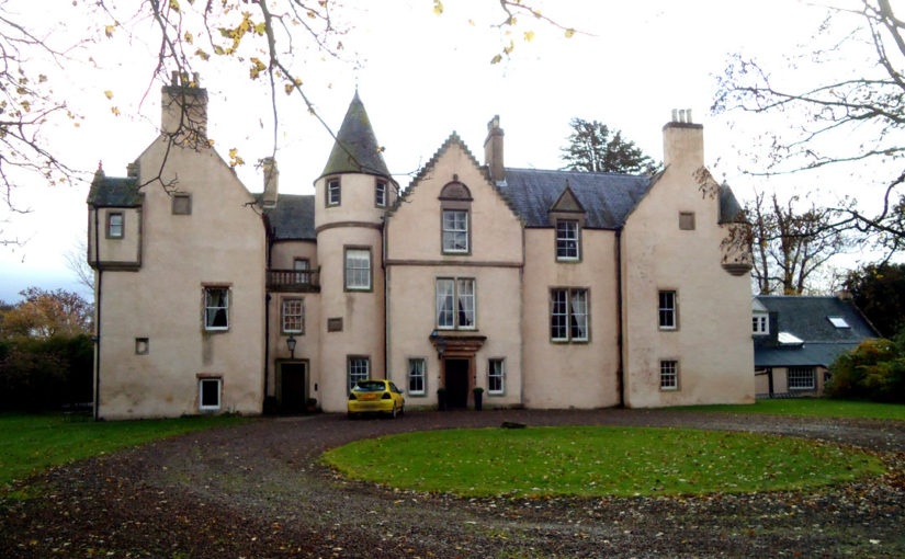
For a family which was amongst Scotland’s richest in the 16th century, their seat was an important place which would have embodied their power and prestige. The great hall, the social heart of the castle, vied with royal palaces in its size. William Keith, 7th Earl Marischal was forced to sell Keith Marishcal during the Civil Wars, and, despite being an important piece of Scottish history, the castle was gradually demolished. Part of the castle survives and was incorporated into the later house built on the site, but much of Keith Marischal has vanished.

Stirling Castle’s great hall. Photo by ‘DeFacto’, licensed CC-BY-SA 4.0.

In 2017, Miles Kerr-Peterson suggested carrying out a geophysical survey to look for buried remains just north of where the house currently stands. He successfully applied to the Castle Studies Trust for funding, and in May 2018 he and Rose Geophysical Consultants visited Keith Marischal to search for the evidence in an area of 2 hectares.

Two methods were used: resistivity and ground penetrating radar (GPR). As different materials conduct electricity differently, testing the electrical resistance of the ground can be used to find features such as walls (high resistance as there is little water) or ditches (low resistance as ditches tend to hold water), and is effective to a depth of about 0.75m. GPR works by sending electromagnetic pulses into the ground and tracking how they are reflected. Part of the area north of the house is a carpark, which makes survey resistivity ineffective, but GPR can still be used.

Deciphering a geophysical survey takes a trained eye. The resistivity survey found several features, and working out what they are has been an interesting challenge. There are two features running in a mostly straight line perpendicular to the current house at the west end of the survey. The longer of the pair could be a drain, but it’s uncertain. And what are the features at the north end? The feature runs beyond the edge of the survey, so we don’t know the full shape and size of it. With trees nearby it could even be part of a root system, but the straight lines suggest it could be man-made and could be part of the lost castle.

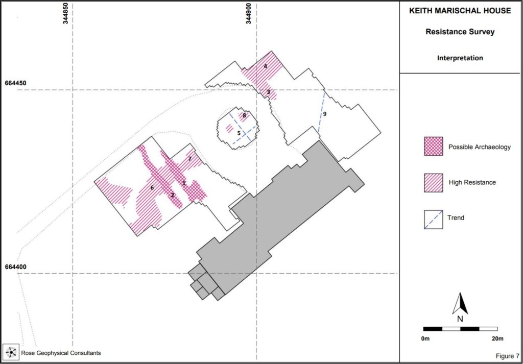
GPR allows us to peer deeper, and to work out a rough stratigraphy of features. The survey was able to corroborate some of the anomalies found with resistivity. The pair of parallel features at the west end are visible, but the one on the right runs deeper. The fact it’s so narrow suggests it might be a drain. The GPR also found an anomaly at the north end of the survey area, lining up with the one found using resistivity. It was visible some 0.38-0.63m deep, which suggests it might be artificial rather than natural.

The results of the survey are certainly interesting. We didn’t find the extent of the lost Keith Marischal Castle, but most discoveries don’t happen overnight. Geophysics is an excellent way to identify areas of interest ahead of excavation. Without excavation, we can’t be sure about the interpretation of these features. If the anomaly at the north end of the survey is part of the lost castle, we don’t have a way of dating it without breaking out a trowel.

The survey was a vital step in the understanding Keith Marischal. Thanks to Miles and Rose Geophysical Consulting, any future excavations will know where to look. Keith Marischal has an exciting future, and the Castle Studies Trust are proud to be able to have played our part in supporting the work.

Dr Miles Kerr-Peterson is an affiliate in Scottish History at the University of Glasgow. His new book, A Protestant Lord in James VI’s Scotland George Keith, Fifth Earl Marischal, touches on the Keiths and is out now.

The six projects we’re funding this year

From 15 high quality applications we had to choose which ones we could fund. It certainly wasn’t an easy decision, but we have managed to support six different projects – the most we’ve supported in a single year – with a total of £22,000. You can learn more below, and if you would like to hear about the results when they are ready be sure to sign up to our newsletter.

Old Bolingbroke, Lincolnshire, England

Photo by David Hitchborne, licensed CC BY-SA 2.0.

Bolingbroke Castle was built by the Earl of Chester in the 1220s and Henry IV was born here in 1367. It is unclear how the Rout Yard and Dewy Hill were used, so Heritage Lincolnshire will carry out geophysical surveys at the castle to find out more about the site.

Pembroke, Pembrokeshire, Wales

Photo by ‘Jez‘, licensed CC BY-SA-NC-ND 2.0.

Founded in 1093, Pembroke is the oldest castle out of this year’s projects. Rebuilt by William Marshall, one of the most famous knight of his age, the castle was also the birthplace of Henry VII. Neil Ludlow and James Meek’s project will excavate in the outer ward to find out more about a late medieval hall. We also funded a geophysical survey at the castle in 2016.

Dig It!, castles of southern Scotland

With funding from the Castle Studies Trust Dig It! will be producing a series of eight videos exploring castles in southern Scotland, and sharing them with an online audience. By making it easier to access information about these important historic sites through YouTube and Wikipedia the project aims to inspire the next generation of castle enthusiasts!

Keith Marischal, East Lothian, Scotland


The Castle of Keith belonged to the powerful Keith family. The castle has since been demolished, with some parts built into Keith Marischal House which now stands on the site. Miles Kerr-Peterson and and Rose Geophysical Consultants will be carrying out a geophysical survey to search for the castle’s lost tower and great hall.

Laughton-en-le-Morthen, South Yorkshire, England


The castle is undocumented in medieval sources, but the earthworks of the motte-and-bailey castle are impressive: the motte itself is 9m tall. To find out more about Laughton-en-le-Morthen Castle, Duncan Wright will be carrying out a geophysical and aerial survey.

Ruthin, Denbighshire, Wales

Photo by Eirian Evans, licensed under a CC BY-SA 2.0 licence.

First documented in 1277, Ruthin Castle was controlled by Reginald de Grey in 1282. This once great castle is a ruin today and much in need of interpretation. To help with this, Chris Jones-Jenkins will create a digital reconstruction of Ruthin. Chris also worked on the reconstruction of Holt Castle, which was built around the same time some 18 miles to the east.

Stay in touch!

We will have updates from these projects throughout the year. Be sure to subscribe to our newsletter so you don’t miss out.

Subscribe to our mailing list

* indicates required


Another Bumper Crop of Applications for the Castle Studies Trust to Consider

The deadline for grant applications passed on 15th December. We’re going through the various projects now. Altogether the 15 projects, coming from all parts of Britain, are asking for over £63,000. They cover not only a wide period of history but also a wide range of topics. For a little more detail, here are the applications we’ve received:

  • Caldicot, Wales – a geophysical survey of the scheduled area of Caldicot Castle using magnetometry, resistivity, and Ground Penetrating Radar (GPR)
  • Dig It! 2017 Castles of South Scotland – enhancing public understanding and knowledge of some castles in southern Scotland, their purpose, their history and their relevance, particularly the lesser-known and least visited sites.
  • Dunyvaig, Scotland – co-funding a project to provide better understanding of the landscape context of the castle by conducting detailed topographic and geophysical surveys and carrying out trial trenching to gain key information regarding the preservation and the depth of the buried deposits.
  • Keith Marischal, Scotland – geophysical survey at Keith Marischal House, in search of a lost medieval castle and renaissance palace with a great hall reputed to be second in size to that of Stirling’s.
  • Lathom, England – excavations to find out the true size of Lathom Castle. You may recognised them from 2017’s grants when we funded analysis of masonry recovered from excavations between 1997 and 2009.
  • Laughton-en-le-Mortain, England  comprehensive archaeological investigation of the motte and bailey castle of Laughton-en-le-Morthen, South Yorkshire and its surrounding landscape.
  • Loch Kinord, Castle Island, Scotland – radiocarbon dating an early island castle: Castle Island, Loch Kinord, Aberdeenshire
  • Old Bolingbroke, England – revealing the history of Old Bolingbroke’s Castles: What can researching Bolingbroke Castle’s Route Yard and Dewy Hill tell us about Bolingbroke Castle?
  • Pembroke, Wales – test trenches at one of Wales’ greatest castles to confirm the site of the late medieval structure revealed in the geophysical survey funded by the CST in 2016.
  • Ruthin Denbighshire – co-funding reconstruction drawing of this great Welsh Edwardian fortress. Ruthin was the town where Owain Glyndwr’s rebellion against English rule started.
  • Sheffield, England – record and examine the architectural fragments stored on the site of the castle found in previous excavations.
  • Skipton, England – an archaeological/architectural survey will be produced of the gate structures and flanking round towers of the inner ward of Skipton Castle.
  • Snodhill, England – geophysical survey and excavations to answer some key remaining questions of this important Welsh border fortress re: the castle namely where was the entrance and function of the North Tower.

The applications have been sent to our expert assessors who will go over them. You can see how the assessment process works in one of our earlier blogs.