Dig Diary Six: Lowther Castle and Village Project Highlights

In her final blog piece (for now) Project Lead, Sophie Ambler, looks back at the three excavation at Lowther

The on-site investigation of the medieval castle and village at Lowther (Cumbria) has now drawn to a close. Over the past month, a team from Allen Archaeology, UCLan, and Lancaster University has been exploring the site through geophysical surveying, excavation and archival research. We now have a geophysical survey of the village to analyse alongside LiDAR and the original earthworks survey. Over the coming months, our small finds will be analysed, together with soil samples, in the hopes that they yield dating evidence, and a report will be prepared drawing together the results from our trenches.

Subscribe to our quarterly newsletter

Meanwhile, we have the chance to reflect on what’s been a thrilling month of investigation.

Uncovering the construction of the ringwork castle and assessing its situation has helped us to get a sense of the site’s place in the broader landscape. Since the area in which the castle stands is now wooded, this takes some imagination.

1. Lowther medieval castle OS map with label

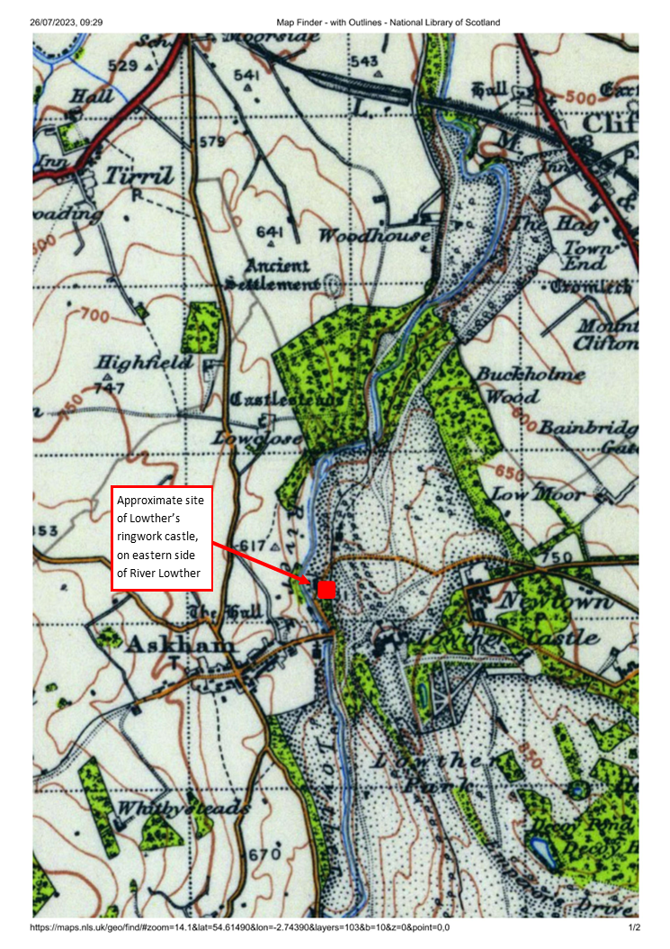
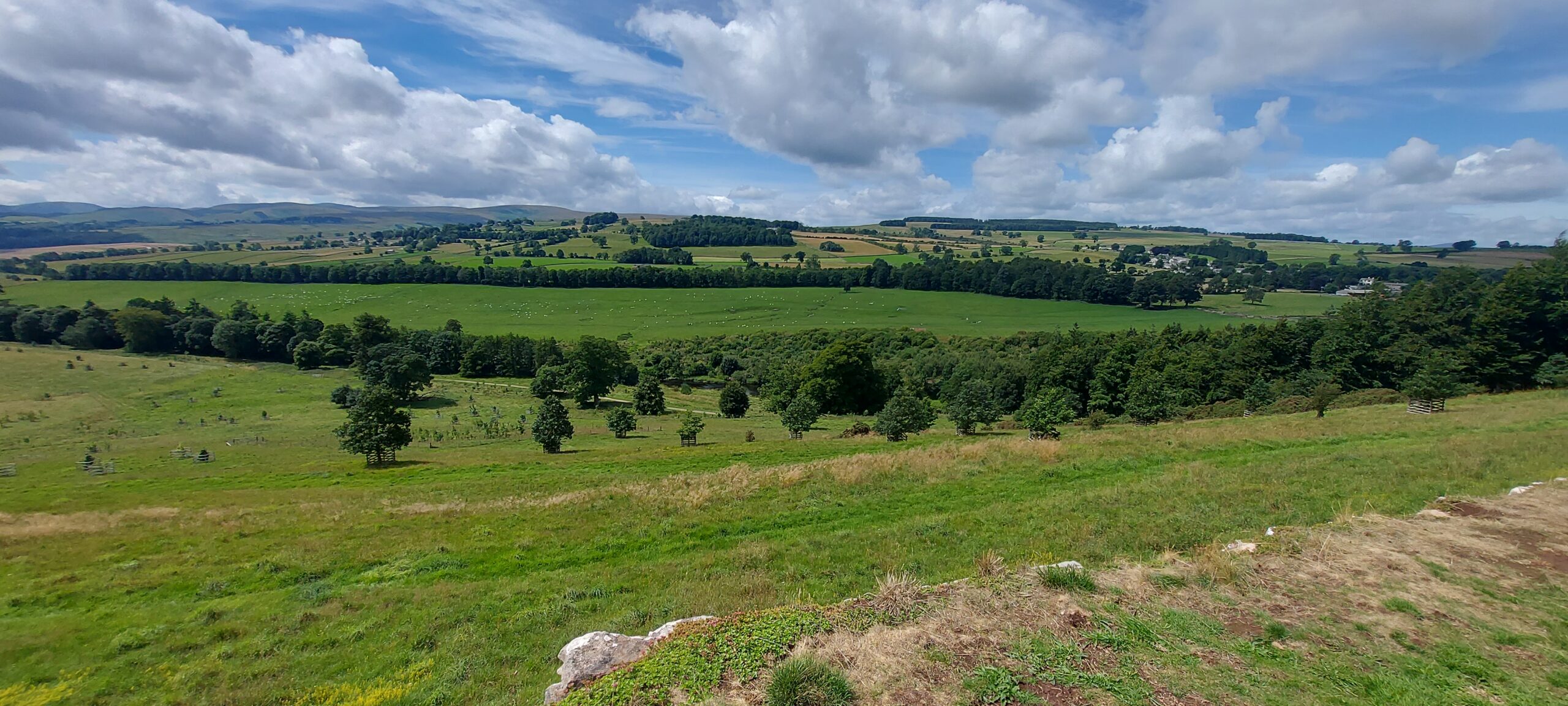
The ringwork castle is sited on the edge of Lowther’s western escarpment, which runs down to the River Lowther. The ringwork’s positioning is clearer in OS maps (image 1), where its proximity to the river and the steepness of the escarpment are evident. Today, one can get some sense of the impact of this positioning by heading eight hundred metres or so south to take the view over the escarpment from the Jubilee Summer House, in the grounds of the nineteenth-century castle (image 2, and view the panorama on Google Maps.), although the escarpment is far less steep here. Originally, the castle would have commanded wide-ranging views to the west, across the river to Askham Fell, and would have been a highly visible – perhaps dominant – landmark for miles around.

View of western escarpment down to River Lowther from south of 19C castle

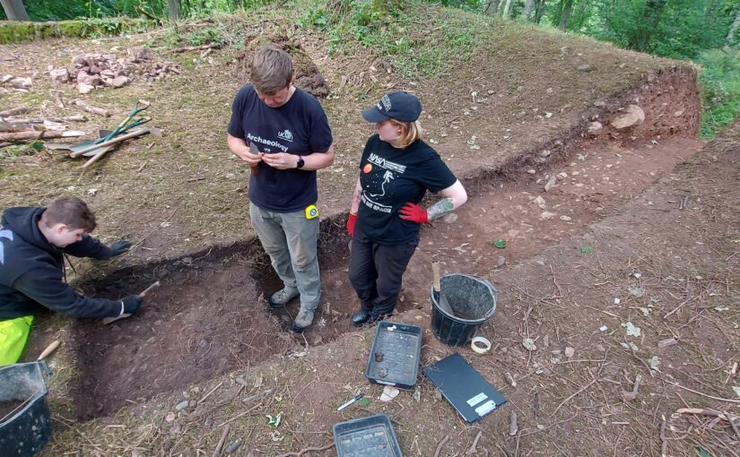
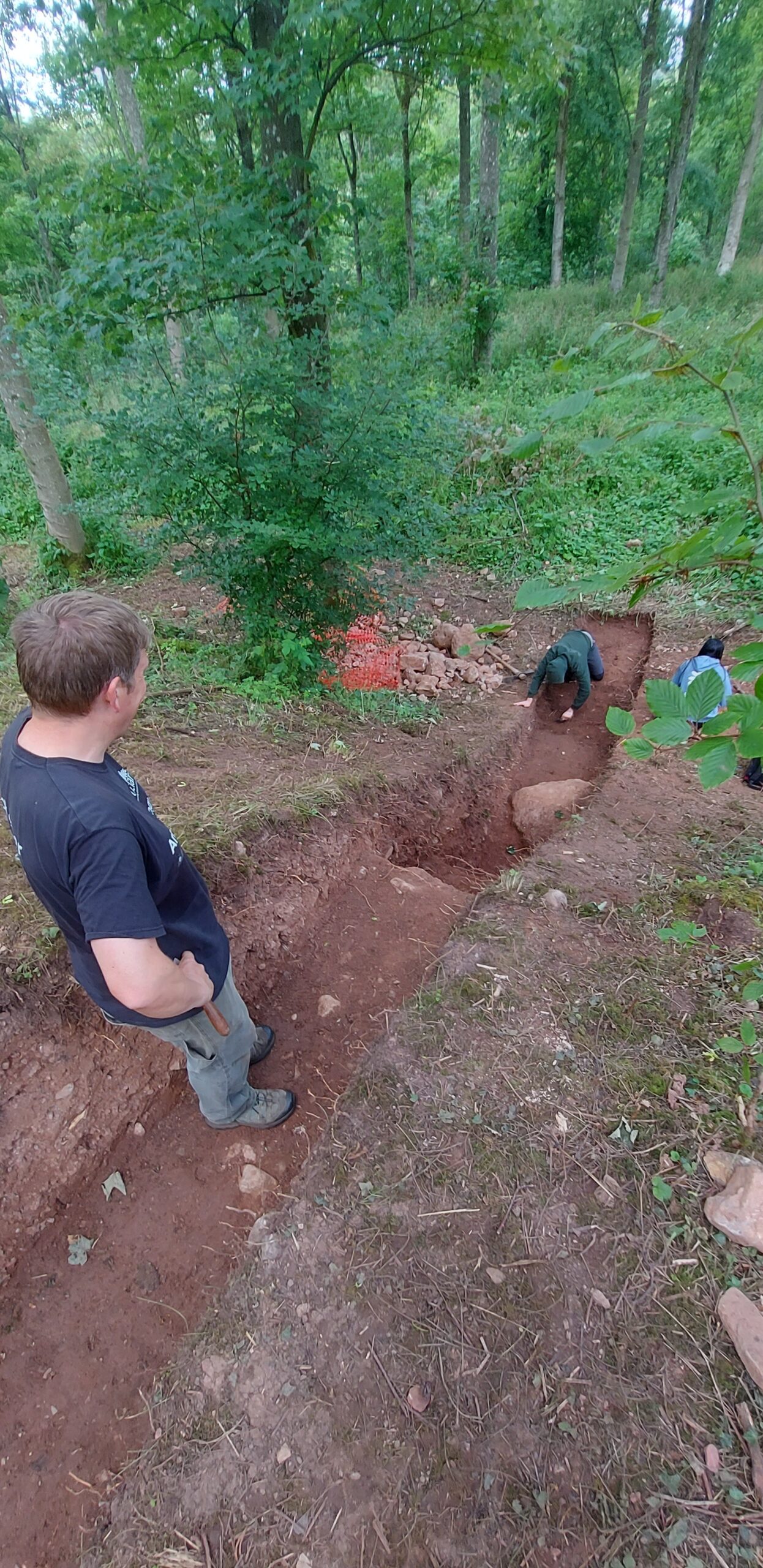
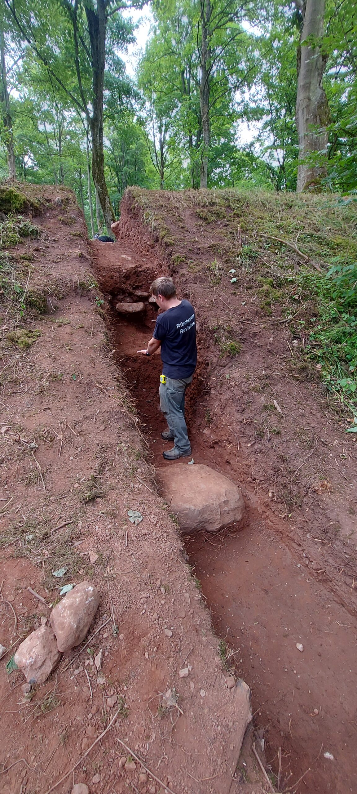
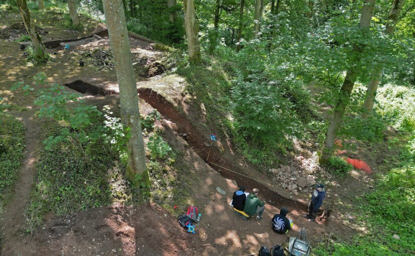
The scale and the construction of the ringwork castle has also become clearer. Again, given the tree coverage and overgrowth, it’s long been hard to perceive the earthwork’s size and form. It’s been hard also to capture the earthwork in photographs – but throughout the project Lowther’s resident photographer, Tony Rumsey, has been busy. His drone footage gives a much clearer sense of the site (image 3). To the top of the picture, the western escarpment drops steeply down from the earthwork to the river. In the foreground, Trench Two cuts into the earthwork’s northern bank.

Drone Trench 2 bank of ringwork castle in woods_Tony Rumsey

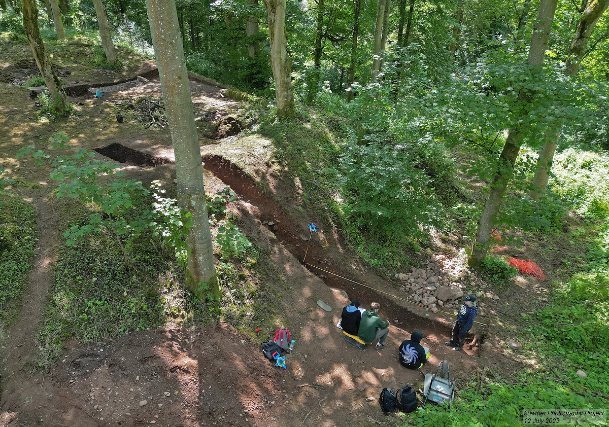
The image also shows how the floor level of the earthwork’s interior is significantly higher than the exterior ground level. As Trench Two revealed, the ringwork was constructed as a large, roughly square mound with layers of earth and stone, with its banks built up further to gird the mound. Meanwhile, the interior was topped with a metalled surface. We expect that the banks would have been surmounted by a simple fence or palisade (Trench Two did not reveal any postholes to indicate this palisade, but this is not surprising given that the top of the bank has almost certainly been lost to slippage).

Drone Trench 4 metalled surface entrance to ringwork castle Tony Rumsey

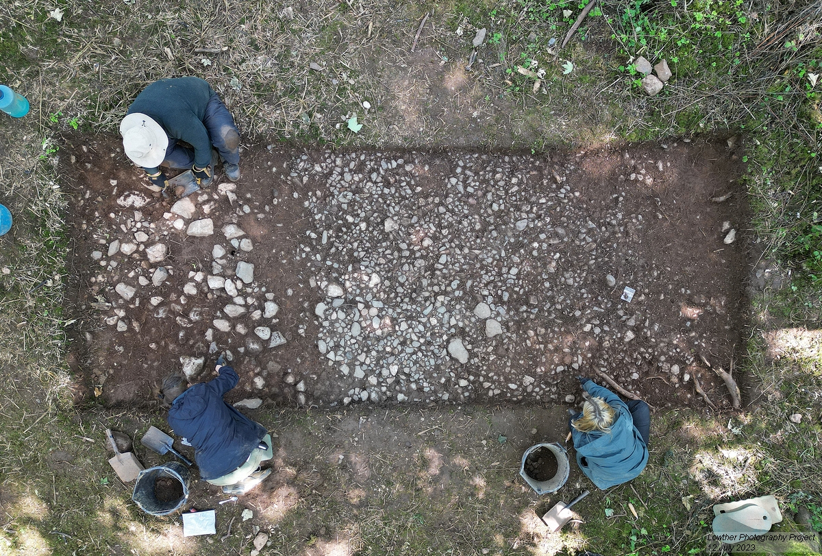
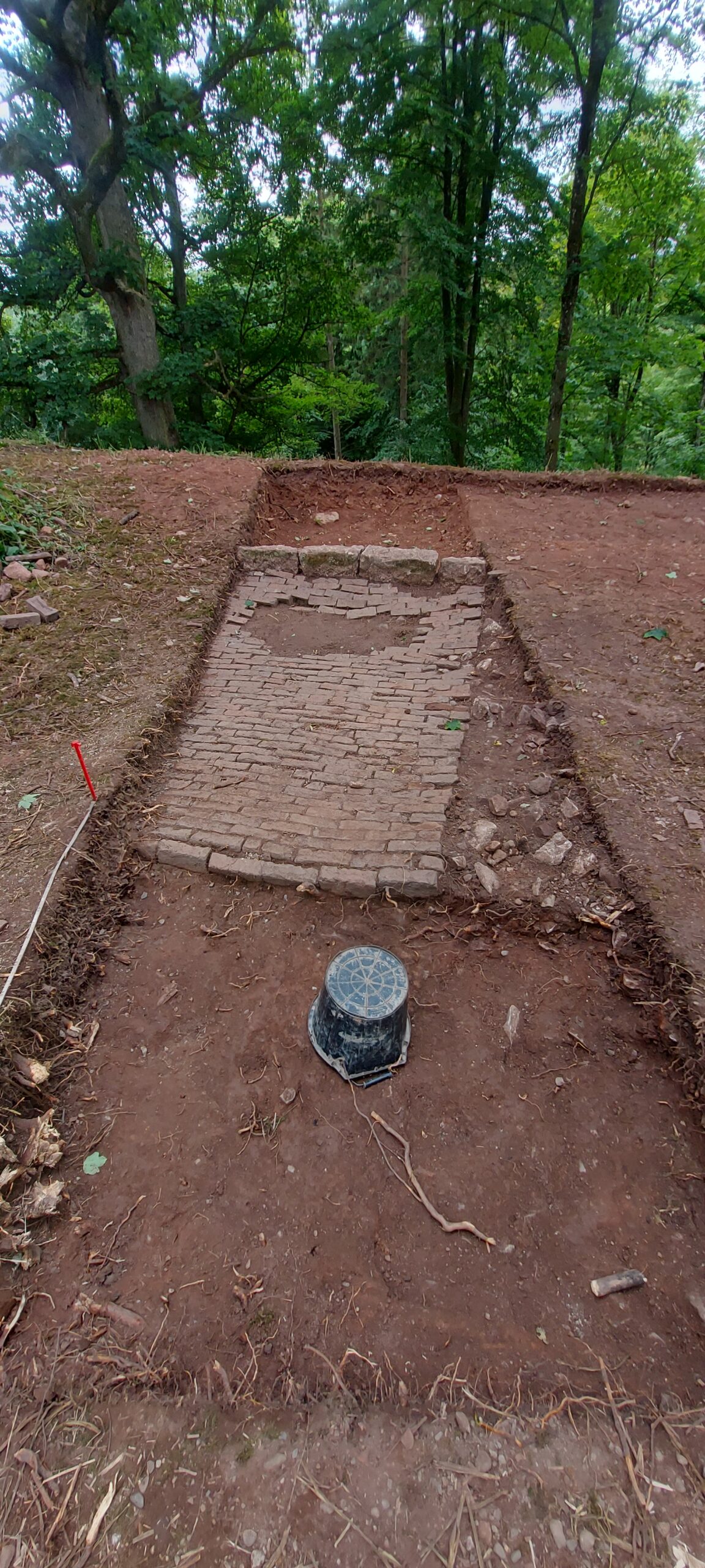
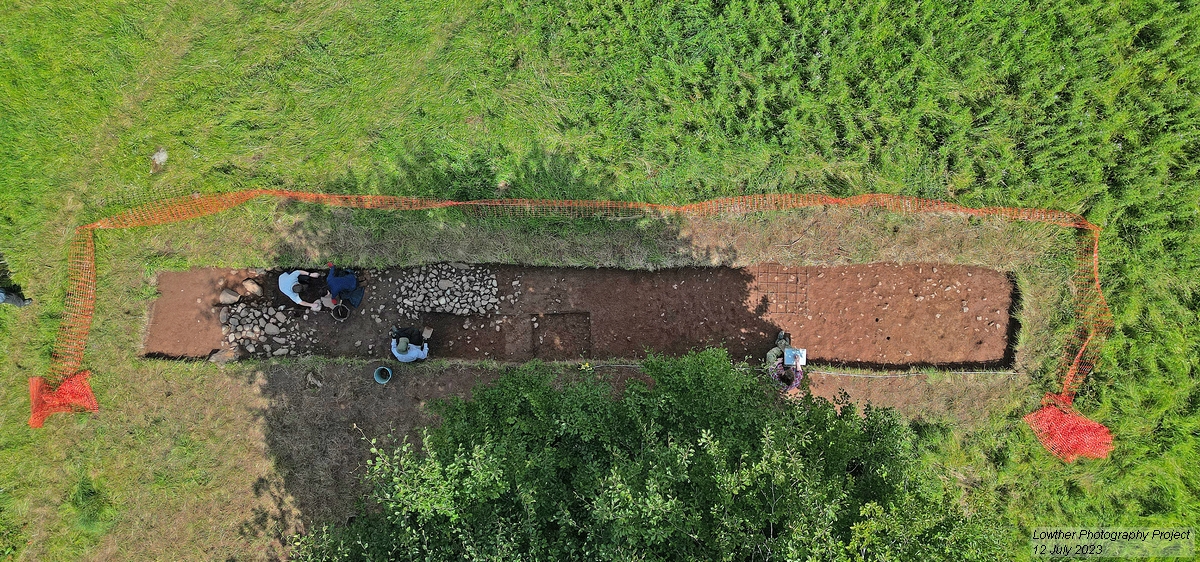
The metalled surface covering the interior of the ringwork is also clear in Trench Four (image 4). This trench takes in the approximate area of the ringwork castle’s entranceway, which cuts through the eastern bank. The entranceway may have included a wooden gateway, although we haven’t found firm evidence of one in Trench Four, and perhaps would need to open a larger area to be sure. Trench Three picked up a trackway (image 5), noted in the earthworks and geophysical surveys, which linked village to castle and brought visitors to the entranceway.

5. Drone Trench 3 trackway into castle_Tony Rumsey_

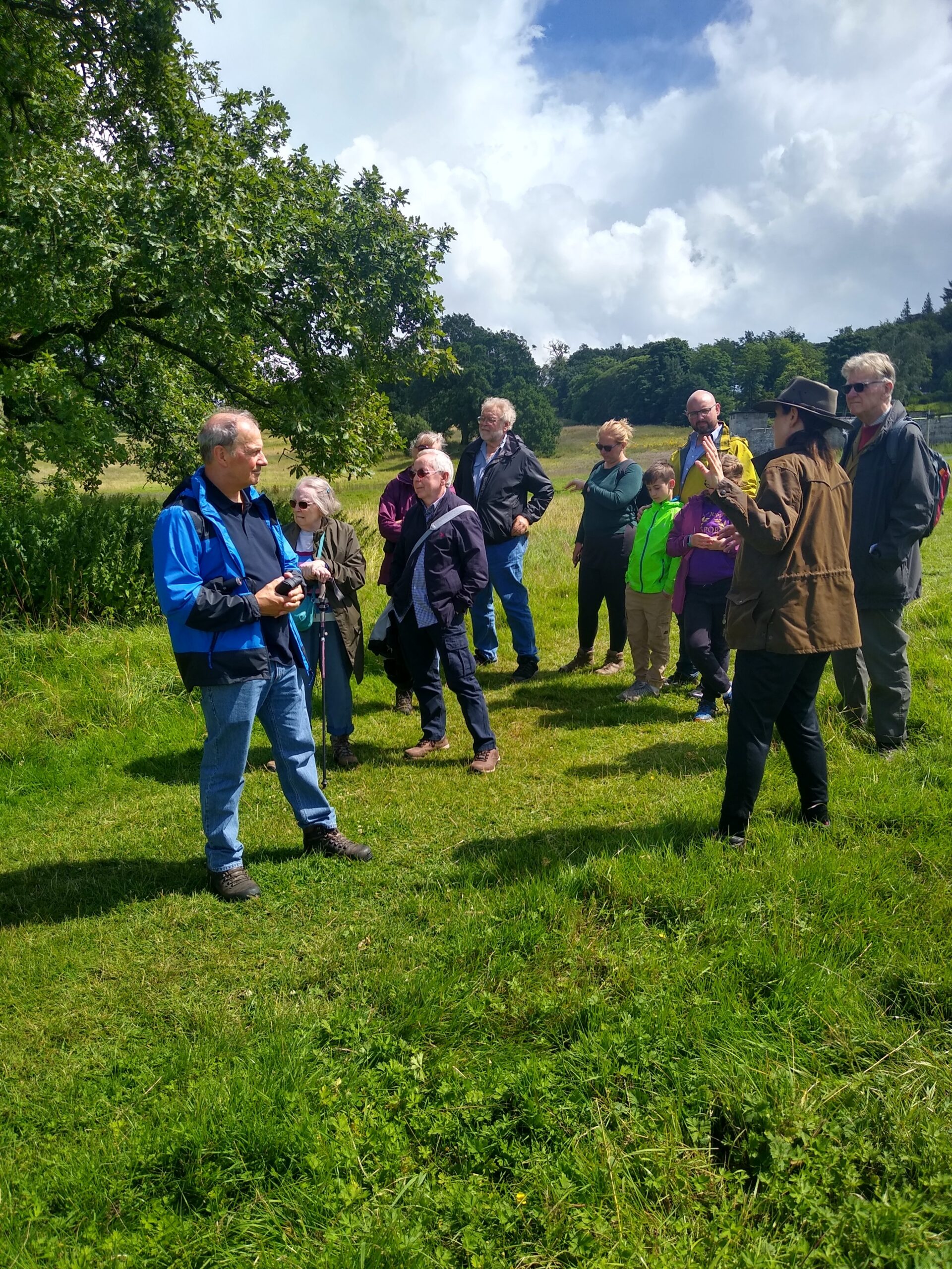
One of the highlights throughout the project has been welcoming visitors to the site. The project’s archaeology students from UCLan have been giving tours to those who’ve ventured down to the site during the course of the dig, keen to know more about what we’ve been uncovering. On Saturday 15 July, we were delighted to welcome representatives of the Castle Studies Trust and share with them our ongoing work (image 6), as well as members of several regional history and archaeology societies. We also had a visit from Professor Alice Roberts and the team from BBC2’s Digging for Britain (image 7), who plan to feature the project in their next series.

6. Visit of CST
7.Digging for Britain with project team

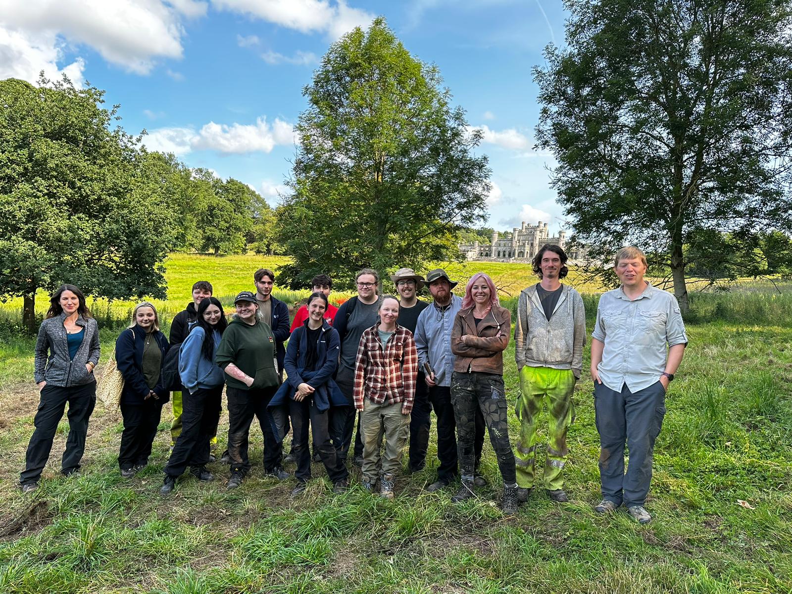
We still have further to go in analysing our findings and expanding our investigation of Lowther’s medieval castle and village, but are very pleased with how the on-site phase of our project has gone – not only in exploring the remains of an important medieval castle site, but also in training a new generation in castle archaeology, and encouraging public appreciation of castle studies. The project team is extremely grateful to the Castle Studies Trust for funding the project and for its support throughout, and would also like to thank the Lowther Castle and Gardens team for their help and hospitality over the past month. I’d also like to say a huge thank you to the indomitable Jim Morris, who has led the UCLan archaeology contingent, the hardworking and dedicated cohort of UCLan archaeology students, and the excellent Allen Archaeology team (Jonny Milton, Rob Evershed and Tobin Rayner).

Subscribe to our quarterly newsletter

Investigating Dunoon Castle

Dr Manda Forster of DigVentures and independent historical researcher Dr Louise Turner set the scene for our next project getting under way – the geophysical survey of Dunoon Castle, Argyll.

On Friday 21 July, members of the public will be joining archaeologists from DigVentures to investigate the remains of Dunoon Castle (NGR: NS 1796 7868; Canmore ID: 40729). The medieval castle site occupies a prominent, partly-modified hill within landscaped gardens which overlook the seafront in the coastal town of Dunoon, Argyll. The town itself is located towards the south end of the Cowal Peninsula at the narrowest point of the Firth of Clyde. This part of the peninsula forms the western shore of a distinct body of water – the north to south oriented sea loch named ‘Holy Loch’ – which adjoins the lower reaches of the Clyde that continue onwards following a more east to west course past Toward Point in the south.

Subscribe to our quarterly newsletter

This community-based investigation, supported by a grant from the Castle Studies Trust, aims to raise awareness of the significant archaeology which sits in the town. Working with local people, the team will explore the archaeology of the site to add detail to the few visible earthworks at the top of the mound with geophysical and topographic survey, including photographic building recording and a drone survey. To get families involved, we’re hosting tours and a character trail around the site, as well as running activities with the Castle House Museum inspired by postcards of the castle and a nod to the town’s history as a visitor destination for those heading on a trip ‘doon the watter’. The project is a collaborative venture by DigVentures with Dunoon Area Alliance, Dunoon CARS and the Castle House Museum which aims to raise awareness of the significant history of the site and find out more about the buried archaeology through a programme of geophysics.

The remains of Dunoon Castle, and the hillock on which it stands, are a designated Scheduled Monument (HES ID: SM5450). The site has a long and complex history linked inextricably with its prominent strategic location in the Firth of Clyde – and with the success of the town itself. The castle hill played a crucial role in the military history of the Clyde Coast during both world wars, and in the town’s success as a holiday destination during the later nineteenth and early twentieth centuries. As a result, the archaeology of the hill extends beyond the medieval castle itself to encompass built elements associated with the nineteenth century landscaped park and gardens.

Dunoon Castle looking north copyright Manda Forster

Little is known or evidenced for early occupation at the site, although ‘seven or eight’ cist burials were discovered in the grounds of Castle House in 1822, during its construction. The description of the burials is comparable with nearby examples of medieval long cists from Innellan (just south of Dunoon), which have been radiocarbon dated to the late tenth century. Early ecclesiastical activity would not be unexpected, and could focus around the site of the modern Dunoon High Kirk. Historically, the earliest documentary mention of the castle was made in 1257 in reference to ‘John of Dunown,’ who was steward to the Earl of Lennox in 1253. From then on, the castle and its associated people, which includes two successive bishops (mid-fifteenth century) and a visit from Mary Queen of Scots in 1563, take a prominent role in the region. The Campbells acquired Dunoon Castle in the 14th century when Sir Colin Campbell, 3rd Lord of Lochow, was granted title of ‘Hereditary Keeper of Dunoon Castle’. The Campbells then retained Dunoon Castle throughout the remainder of the medieval period, and beyond. A document dated 15th January 1472 outlines their responsibility for the upkeep of the castle and the maintenance of its fabric, as well as the power to appoint constables, porters, jailors, watermen and other officers. By the end of the medieval period, Campbell influence was growing ever greater in this SW corner of the Cowal peninsula but, following the grisly Dunoon Massacre* in 1646, the castle seems to have been deserted. After its abandonment, stone from Dunoon Castle was probably used locally for housing, including for the construction of Castle House and associated structures (now the location of the museum).

Postcards of Dunoon through the ages

The site itself retains its nineteenth century character, having been retained within a larger area of landscaped gardens. The planned investigations have the potential to explore whether there are undiscovered features relating to earlier occupation of the castle mound (Phase 1) and provide an updated record of the extant remains which relate directly to the medieval castle (Phase 2). In delivering the survey, we also hope to further refine our understanding of how the configuration of the gardens and landscaped grounds may have changed from the early nineteenth century to the present (Phase 3) and to record any extant evidence for the twentieth century coastal defences (Phase 4).

Subscribe to our quarterly newsletter

*The 17th century was brutal for the clans in the area as it was across Scotland, with a backdrop of war and switching allegiances. Within this context, the Lamonts and Campbells found themselves on opposing sides, and the Lamonts invaded Campbell lands killing 33 men, women and children. In 1646, the Campbells struck back, attacking the Lamont castles of Ascog and Toward (just down the coast) and capturing around 100 Lamonts who were sentence to death and executed. Thirty-six of the highest ranking were hanged from a tree in the graveyard. A memorial now stands to Clan Lamont at Tom A’Mhoid road.

Dig Diary Five: Digging in to the archives part two

In the fifth of our Dig Diaries Sophie Ambler discusses the work she is doing investigating the Lowther archives and seeing how the written record helps with the archaeology.

In the third Dig Diary for the Lowther Castle and Village project, I introduced the (patchy) written evidence for the Norman conquest and colonisation of Cumbria – potentially when our site was established. Here, I’ll introduce some of the earliest written evidence for our site, dating from the thirteenth century.

Our evidence comes from the archive of the Lowther family, held in the Cumbria Archive Centre in Carlisle. This archive is largely uncatalogued, held in boxes arranged by manor (administrative units within the larger estate). There are six boxes pertaining to the Lowther manor, containing several centuries’ worth of documents. Sifting through them is a long but exciting task.

Subscribe to our quarterly newsletter

Readers might have spotted that ‘Lowther’ – the name of the family that has held the estate for centuries, as well as the name of our manor and village – is not a Norman name. In fact, ‘Lowther’ is the name of the river running below our site. The name’s origins are uncertain but might derive from the Old Norse for ‘foaming water’. The Lowther manor and its principal settlement (our village site) took their names from the river, and the family took its name from the manor and/or village. This practice was common in the thirteenth century. People didn’t generally have surnames (sometimes occupational names, e.g. John le Carpenter), and were often referred to either by their parentage (e.g. John fitz/son of Agnes) or their home (e.g. John of Hackthorpe).

Our central character is Hugh fitz Geoffrey of Lowther – or, as he was more commonly known, simply Hugh of Lowther. In the 1280s, Hugh was one of several men known as so-and-so ‘of Lowther’. He was one of the manor’s four leading landholders, who held their lands in Lowther from a tenant-in-chief of the king. But it was Hugh who would make his fortune, so that in the fourteenth century his descendant could be described as ‘Hugh of Lowther, lord of Lowther’.

Hugh made his money as a sergeant (an early form of barrister) in the central courts of King Edward I. His career has been traced by Professor Paul Brand, who has researched the emergence of a new class of professional lawyers in the late thirteenth century. Hugh, together with his wife Ivette, used the money earned practising law to build a property portfolio in Lowther manor and village. By c.1292, Hugh had become a knight. (He also went on to take part in Edward I’s conquest of Scotland, but that’s another story!)

Charter of Alice daughter of Peter of Thrimby for Hugh de Lowther_Carlisle DLONS-L-5-1-26 LO35. Alice-castle

It’s the documents drawn up for Hugh and others of the manorial community to record grants, sales and exchanges of land that provide our evidence for the site. These give the names of the women and men granting or receiving property, the names of the men who stood witness to a grant, and the parcels of property conveyed – sometimes described with highly localised placenames, and landmarks.

Using this material as evidence for the landscape and use of our site, together with archaeological findings, will be a long and fiddly process, but here’s a taster.

This is a charter, dating probably to the 1280s, recording two points. First, a grant of two acres of land in Lowther by Alice daughter of Peter of Thrimby to Hugh of Lowther (comprising various small parcels, each described by local names). Second, Alice’s quitclaim to Hugh of rights in three acres and half a rood of land (there were four roods in an acre) in the vill of Lowther, which she and her late husband, William fitz Richard of Hackthorpe, had demised to Matthew of Rosgill, chaplain. Again this land is broken into parcels, each described. One of these is half a rood (an eighth of an acre) ‘above the castle’. You can see ‘castellum’ along the lateral fold of the charter. 

Could this refer to the ringwork castle we’re investigating? This would be a good bet, as there is no evidence of another castle on the site at this date. In which case, this reference gives us a glimpse of how people in the village were using the castle as a marker in their landscape.

Subscribe to our quarterly newsletter

Follow the project on Twitter via the hashtag #LowtherMedievalCastle

Charter archive reference: Carlisle Archive Centre, Carlisle, DLONS/L/5/1/26 LO35, Copyright Lowther Estates.

Lowther Dig Diary Four: Lots of questions not many answers…yet

At the end of week two of the #LowtherMedievalCastle dig and project lead Sophie Ambler gives us the latest update.

At the end of week two, we’re half way through our excavation of Lowther Medieval Castle and Village, and revealing some intriguing results.

We now have four trenches open, three exploring the medieval castle earthwork and one across the routeway linking castle to village. There is still a great deal of work to be done, so much of what follows involves some speculation, and these findings are very much preliminary!

Subscribe to our quarterly newsletter

Trench One: Brick Patio

Trench One, on the western side of the castle earthwork, has revealed a small brick patio, bounded on the western edge with a course of cut stones. Miscellaneous finds, including a degraded iron doorhandle and pottery sherds, suggest that this might represent a phase of use concurrent with the nineteenth-century castle. Today’s Lowther Castle, the ruins of which overlook the site, was commissioned in 1806 by William, 1st Earl of Lonsdale. One theory is that the patio relates to the ‘Countess’s Stairs’, which once led up the steep slope from the River Lowther – perhaps towards the patio or a now-lost structure, which may have afforded a view across the river.

Trench Two: view down northward slope from top of northern bank

Trench Two, which cuts through the northern bank of the medieval castle earthwork, is starting to give us a real insight into how the fortification was constructed. We might expect with a ringwork castle for the bank to have been built using earth taken from an encircling ditch, but there is no evidence of a ditch at present. Instead, the bank appears to have been formed from material scoured from the immediate area: both the flat stretching north of the earthwork and the steep slope down to the River Lowther, a rich source of limestone. The bank appears to have been constructed in alternating layers of earth and stone. The team will continue working their way through the layers in this trench, in the hope of revealing more of the bank’s construction, and picking up any small finds that will provide us with dating evidence.

Trench Two northern bank of castle earthwork viewed from exterior showing layers of construction demonstrated by Jim Morris of UCLan

At the southern end of Trench Two, within the castle earthwork’s interior, is a metalled surface that may be the original medieval surface. This might tie into emerging discoveries in Trench Four.

Trench Four is our newest trench, opened over the entrance to the castle earthwork on its eastern side. Already this is beginning to yield evidence of what looks to be the same metalled surface evident in Trench Two. If so, this could suggest the original medieval metalled surface leading into the castle from the village and stretching across the floor of the ringwork. No evidence of this surface is evident so far in Trench One, either because it was destroyed by the intrusion of the nineteenth-century patio, or because the metalled surface did not cover the entirety of the castle interior. Within Trench Four, amidst a stone layer to the north of the metalled surface, is what might just be evidence of a post hole. Could this represent one side of the castle’s gateway? Watch this space!

Trench Three is another relatively recent trench taking in what is likely to be the routeway into the castle from the village, and what might be structures or plots lining the routeway. This has so far yielded two patches of disordered stone to the north of the routeway; one theory so far is that these represent demolition undertaken when the village was cleared in the seventeenth century.

All four trenches will hopefully have more to tell us as the team continues work over the second half of the project.

Subscribe to our quarterly newsletter

You can follow the project’s discoveries on Twitter via the hashtag #LowtherMedievalCastle

Lowther Dig Diary Three: Digging up the historical evidence of Lowther medieval castle and village

In part three of our dig diary, project lead Sophie Ambler talks about another type of digging, not of holes in the ground by through the archives to discover what if any historical evidence there is for Lowther.

Whilst the archaeologist are at work on site at Lowther, I’m attempting to piece together the site’s history from the documentary evidence.

Our biggest challenge is tracing the origins of Lowther’s medieval castle and village, which we think date to the late eleventh or early twelfth century. For most of England, historians have a phenomenal source for settlement in the eleventh century: Domesday Book. This was William the Conqueror’s enormous survey of landholding, compiled in 1086. It gives various details, settlement by settlement, such as landholders, land under cultivation, notable buildings and households (for an introduction to Domesday and the latest research, listen to this BBC History Extra podcast by Professor Stephen Baxter). Domesday thus helps historians to trace the process by which the Normans conquered England over the twenty years from 1066.

Subscribe to our quarterly newsletter

Frustratingly for us, the area of modern Co. Cumbria doesn’t appear in Domesday Book. Because this region wasn’t conquered by William I, it found no place in the Domesday survey. As discussed in our project’s first Dig Diary entry, the region was only conquered in 1092, by William the Conqueror’s son, William Rufus. The Anglo-Saxon chronicle states that William Rufus, following his campaign of conquest, ‘sent many peasant people with their wives and cattle to live there and cultivate the land’. This was, effectively, a process of Norman colonisation. We’re hypothesising that the ringwork castle earthwork and village at Lowther date to this era.

What was this region like when the Normans arrived in 1092? Here, historians have worked hard from patchy evidence for the Kingdom of Cumbria in the tenth and eleventh centuries. This was a Brittonic kingdom (distinct from the Anglo-Saxon kingdom of the south) but, as Professor Fiona Edmonds has described, parts of the kingdom were ‘multi-lingual and multi-cultural’ (including settlers we might think of as ‘Vikings’ and their descendants). These groups were encompassed by the term ‘Cymry’ (‘inhabitants of the same region’), from which the names Cumbria and Cumberland derive.

Who were the settlers dispatched in 1092 by William Rufus to colonise the Kingdom of Cumbria? There’s no hard evidence, but Dr Henry Summerson has suggested (in his book Medieval Carlisle) that they hailed from Lincolnshire. This theory has found some support from the late Professor Richard Sharpe, although he noted that evidence for a Lincolnshire connection dates to around 1100, so may represent a second wave of settlement.

Subscribe to our quarterly newsletter

Our first major evidence for Norman rule of the region comes in 1130, under King Henry I (William Rufus’ brother). This is found in a Pipe Roll – a record produced by England’s central government detailing the Exchequer’s annual audit, so-called because the parchment membranes were sewn together at the top and rolled up to look like a pipe (read more on the Pipe Roll Society website). The first surviving Pipe Roll dates to 1130. Professor Sharpe used this and other evidence to reconstruct the early Norman administration of the region. He concluded that the Normans formed the shires of Cumberland and Westmorland out of the old Kingdom of Cumbria by 1130, and were administering these shires under the aegis of central government. Even then, however, both counties were run ‘as a territorial unit’ rather than shires proper, overseen by an administrator rather than fully-fledged sheriffs. (You can read Professor Sharpe’s analysis in full here). This is perhaps not surprising, given that in southern England the Normans could co-opt the governmental systems of the Anglo-Saxon state, including shires and shire courts. Cumbria was a different beast.

Is this all to say that written evidence can’t tell us much about the Norman conquest of Cumbria in general, or about our site in particular? Yes and no. It does highlight the importance of archaeological investigation in filling the gaps in written evidence – and suggests how findings from the Lowther Castle and Village project could be significant to both historians and archaeologists in tracing the process of Norman conquest and colonisation and its realities on the ground. On the other hand, we do have written evidence for the Lowther site dating from the thirteenth century onwards, which we can use together with the archaeology to trace the site’s biography. More of this in a forthcoming post!

Subscribe to our quarterly newsletter

Follow the project on Twitter via the hashtag #LowtherMedievalCastle.