Haverfordwest’s town wall revealed?

Neil Ludlow and Phil Poucher of DAT look at the results of the investigation at Haverfordwest Castle by Dyfed Archaeological Trust (DAT), as part of a major infrastructure scheme embracing the castle and its setting, has revealed what may be part of the medieval town wall, long thought to have been entirely destroyed.

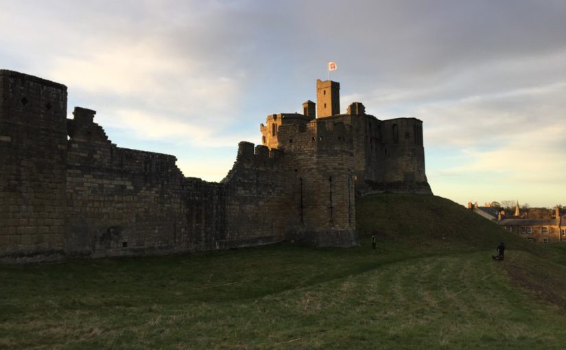
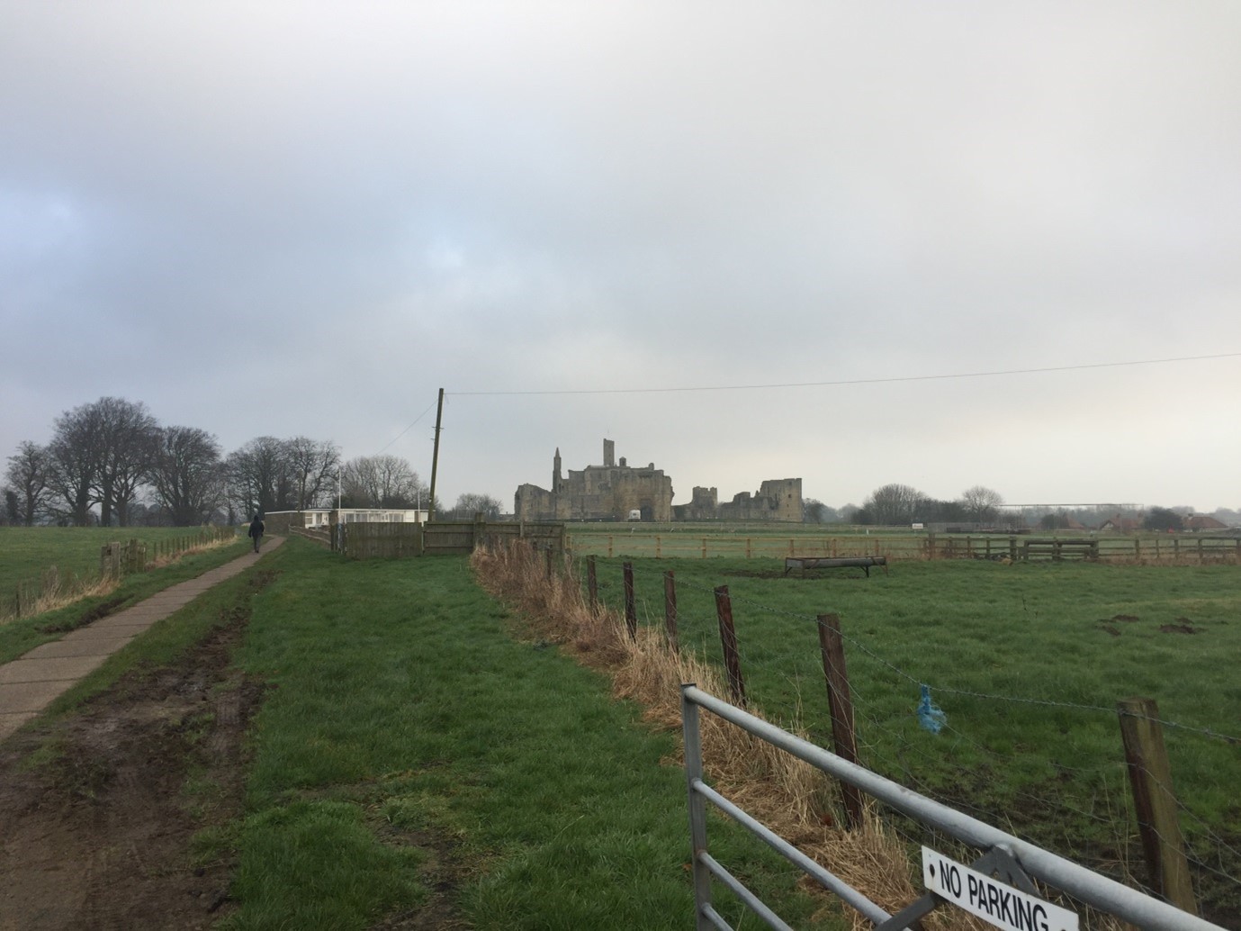
The remains of the castle still dominate views of the town, particularly from the main eastern approach, crowning a steep bluff overlooking the Western Cleddau river. Founded around 1110 by one Tancard, a Flemish colonist, the castle appears to have begun as a partial ringwork and bailey, perhaps adapted from an Iron Age hillfort. Fortification in stone began under Tancard’s grandson Robert FitzRichard, a decade or so either side of 1200, with the erection of a subrectangular donjon; a curtain wall with at least one round mural tower was later added, possibly by the younger Marshal earls of Pembroke between 1219 and 1245. The castle was transformed into a palatial residence with the addition of an integrated suite of apartments of the highest quality, including hall and chamber-block ranges, and a terraced garden enclosure; they are traditionally attributed to Edward I’s queen Eleanor of Castile who received the castle and lordship two years before her death in 1290. The outer ward was also walled in stone, probably during the early fourteenth century. Although it played no part in the second Civil War of 1648, the castle was partially slighted on Cromwell’s orders and was subsequently used as a gaol, which closed in 1878.

Open to the public since 1970, and housing the town’s museum and County Record Office – but still perhaps an under-valued asset – the castle is now the subject of an enhancement programme to improve access, carry out essential repairs and redevelop the museum. The scheme extends to the castle’s setting, with improved landscaping and restoration of the surrounding burgage-plot boundaries. Preliminary archaeological work includes geophysical survey and test-pit recording.

Figure 1: The walling and archway from northeast. The castle donjon is at far left.

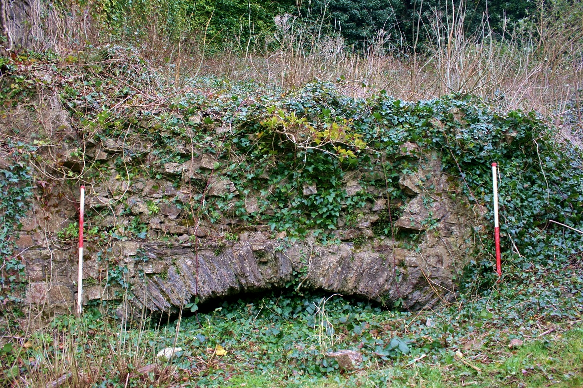
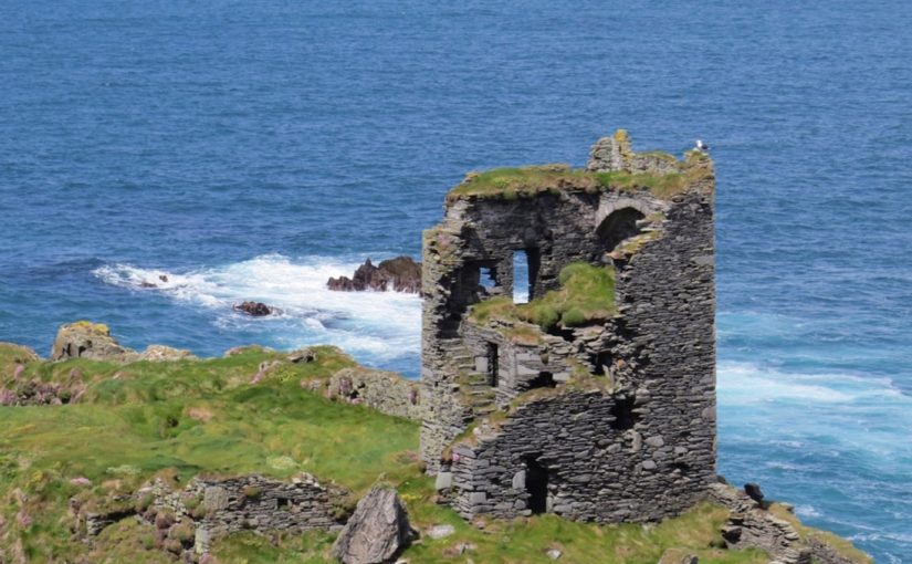
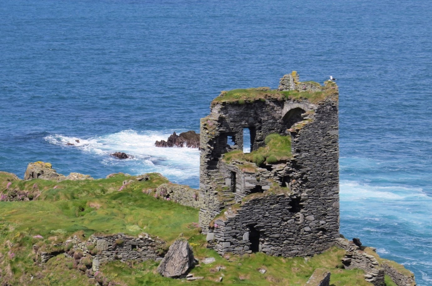
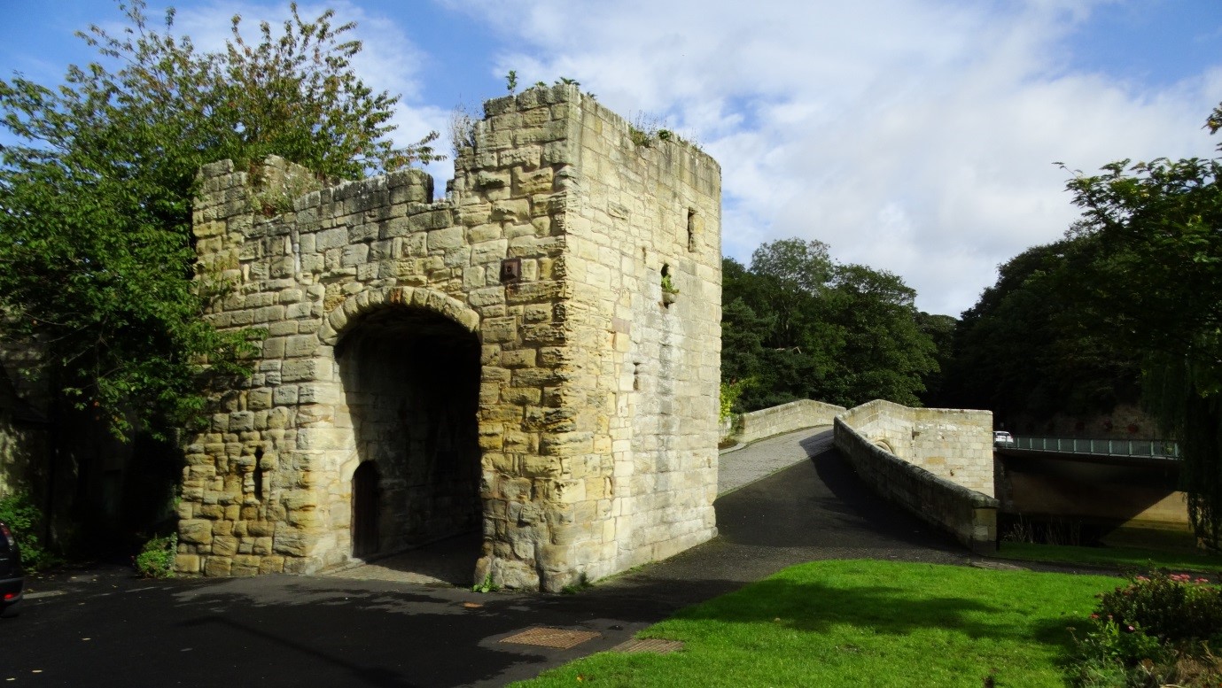
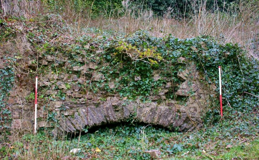
Investigating the castle exterior in early 2021, at the summit of the steep bluff, Andy Shobbrook of DAT came upon a stretch of walling that appears to have evaded previous investigations. Now of no great height, but probably truncated, it is pierced by a wide segmental arch of convincingly medieval form (Fig. 1). Although absent from published plans and descriptions of the castle, it is shown on the large-scale 1:500 map of the town produced by the Ordnance Survey in 1889, on which it is labelled ‘Arch’ in the Gothic script reserved for antiquities (Fig. 3). It lies just within the scheduled area of the castle, corresponding with its boundary, and appears to be in a stable condition.

Figure 2: Plan showing the conjectured layout of Haverfordwest in c.1300

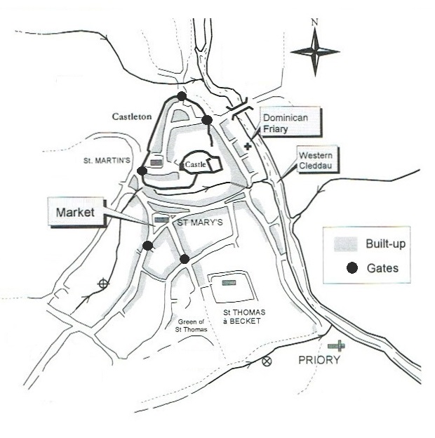
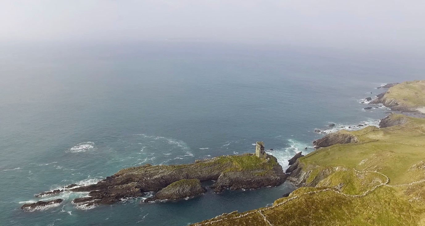
The walling may be part of the medieval town wall rather than the castle defences. The town of Haverfordwest, which is notable for its three medieval parish churches – unique in Wales – was founded soon after the castle and by the close of the Middle Ages had become the de facto county town of Pembrokeshire. Defended by an earthen bank and ditch from an early period, probably before 1200, it was walled in stone after the issue of a murage grant in 1264. The defended area was relatively small, immediately next to the castle and always known as the ‘Castleton’ – while the extensive suburb around the extra-mural marketplace to the south received fortified gateways, they were never connected by any solid barrier (Fig. 2). The town wall had largely disappeared by 1700 and, while the gatehouses survived rather longer, the last were removed at the end of the eighteenth century.

Figure 3: An extract of the Ordnance Survey 1:500 map of Haverfordwest, of 1889,
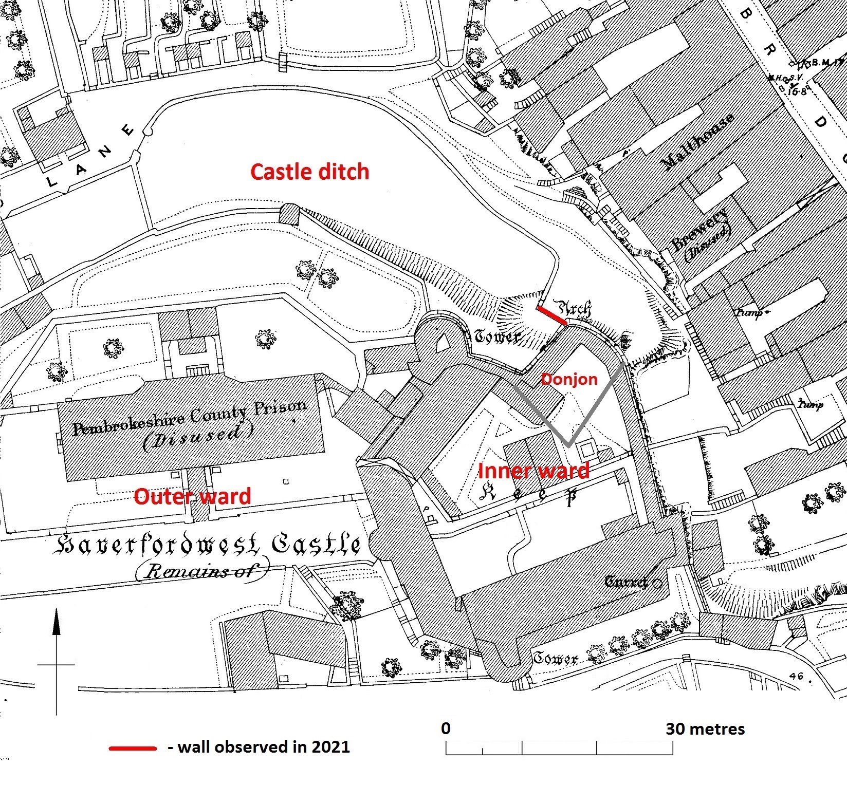
showing the castle and walling (labelled ‘Arch’).

Vestiges of the wall were apparently still detectable in 1900 but all traces were thought to have been lost soon afterwards. Stretches of its former line are marked by property boundaries but its entire course is not precisely known, nor the points at which it connected to the castle defences. The walling discovered in 2021 butts against the donjon at the northeast corner of the castle inner ward, and runs northwest for 5 metres before petering out. The remains of a return at its northwest end correspond with a 90° turn shown on the 1889 map, on which it is shown to then run north-eastwards before turning west to continue along the outer edge of the castle’s northern ditch. But the medieval wall must have deviated from this line at some point, to run northwards to the eastern town gate. The arch is 3 metres wide but was probably always too low – and perhaps too wide – to represent an entry. Its function may simply have been to drain the area immediately to the west, which slopes steeply downhill towards the east and seems to have been a continuation of the castle ditch where it ran out at the crest of the bluff (Fig. 3). Two phases of work within the arch are possible, suggesting it was modified and perhaps narrowed at some point.

Subscribe to our quarterly newsletter

Dún an Óir Castle: an uncertain future

Dr Sarah Kerr of Trinity College Dublin discusses the ongoing project to look at the impact of climate change on castles with a focus on the ones in West Cork, as they are battered by Atlantic storms.

Over the past two years, two small grants (Research Incentive Scheme, Trinity College Dublin, Ireland; and Higher Education Innovation Fund, UK) has funded research into the impact of climate change on built heritages, and the identification of those most vulnerable, particularly in West Cork, in the south-west of Ireland. Dún an Óir is one such castle at risk, on the edge of Ireland, on the brink of the West Cork cliffs and at the mercy of the increasingly frequent Atlantic storms and high winds.

Dún an Óir is a castle at risk, on the edge of Ireland, on the brink of the West Cork cliffs and at the mercy of the increasingly frequent Atlantic storms and high winds. Dún an Óir is an Irish tower house, a type of stone-built castle, smaller than the sprawling castles built by the Anglo-Normans, such as Trim, County Meath and, indeed, serving a different purpose. The relative small size of tower houses placed their construction within the financial reach of lords, emerging gentry and merchants in both rural and urban areas. Tower house construction commenced on the island of Ireland (Ireland hereafter) in the mid-fourteenth century and flourished in the fifteenth and sixteenth, construction ceasing by 1650. Their abundance led Terry Barry to state that Ireland was ‘the most castellated country in Europe in the late middle ages’ (Barry 2008, 129) or at least ‘one of the most castellated parts’ of the Irish and British Isles (Cairns 1987, 31; O’Connor 1998, 25). If so, then Munster in the south-west of Ireland was a focal point of this activity. The West Cork area in the south-western extent of Munster contains 47-known tower houses, many concentrated along the jagged and island-dotted Atlantic coast. The West Cork tower houses are of particular interest as they are the only castle type remaining in the region; plus, contemporary written evidence allows the majority to be ascribed to a certain clan.

Dún an Óir (Doonanore when anglicised) is located on the island Oileán Chléire (Clear Island), approximately 13km from the Irish mainland. It was built by the O’Driscoll clan in the mid-sixteenth on a coastal promontory (Figure 1). Located on the coast, along with several other known O’Driscoll tower houses, its occupants could oversee the movement of goods through Roaringwater Bay as well as charge passing vessels for anchorage, victualing and exploitation of the waters (Figure1). 

This once strategic position is Dún an Óir’s Achilles heel. The building and its immediate landscape are precarious, unconsolidated and unprotected (Figure 1). Exposed on a partially collapsed promontory, its long-term survival is unlikely and our time to understand it short.

Figure 1: Photograph looking north across Roaringwater Bay towards the Atlantic showing Dún an Óir on a rocky promontory.

Dún an Óir comprised four-storeys rising from a rectangular ground-plan. Access was through the south wall, although the east wall faced the neck of the promontory (where it connected to the remainder of the island). Much of the south wall has collapsed yet a garderobe tower remains to the east of the door (Figure 2). Above the doorway a mural staircase (built within the thickness of the wall) can be seen leading to at least the first and second floors. There is a vaulted ceiling between the second and third floors in the form of three pointed arches separated from one another by overlapping slabs.

Figure 2: Dún an Óir tower house, from the southeast, showing the mural staircase extending upwards along the south wall (with thanks to Finola Finlay and Robert Harris for the photograph).

A significant and surviving feature of Dún an Óir is its bawn (curtain wall): a stone wall which in this case abuts the tower house (rather than surrounding it) and stretches west to enclose the remainder of the promontory (Figure 3). Vicky McAlister’s recent book on tower houses indicates that the survival rate of bawns is low compared to the tower houses themselves (McAlister 2019, 22), recalling earlier suggestions that the current 1 in 5 survival rate may be representative of their former inclusion. Dún an Óir is a relatively rare example of preserved ancillary buildings within the bawn. Although they remain only as overgrown footings, there appears to be a kitchen with oven, and two more apparently feature-less buildings that appear to be contemporaneous with the bawn wall (Figure 3).

Figure 3: A simple plan of Dún an Oir tower house, bawn, and ancilliary buildings. The proximity tit he promontory edge is clear.

Dún an Oir’s bawn reaches to the edge of promontory, almost certainly to be further damaged or lost in this lifetime. With this seemingly fixed future, the onus shifts to the researching community in the present to document what we can: this is discussed further in a recent paper on the castle (Kerr 2019). The erosion to the promontory renders further buildings survey, as well as geophysical survey or excavation, no longer safe. Therefore, the next steps of fieldwork may include airborne LiDAR. Greater exploitation of innovative surveying methods may overcome the difficulties posed by the physical landscape and allow the tower house, bawn and ancillary buildings to be understood to a greater depth before the inevitable happens.

Subscribe to our quarterly newsletter

Barry, T. 2008. The study of medieval Irish castle: a bibliographic survey. Proceedings of the Royal Irish Academy: Archaeology, Culture, History, Literature 108(C), 115–36.

Cairns, C. 1987. Irish tower houses: a Co. Tipperary case study, Group for the Study of Irish Historic Settlement.

Kerr, S. 2019. Reconnecting Cultural Landscapes: Dún an Óir, West Cork, Ireland, Landscapes, 20:2, 160-177, DOI: 10.1080/14662035.2020.1861725

McAlister, V. 2019. The Irish tower house, Manchester University Press.

O’Conor, K. 1998. The archaeology of medieval rural Settlement in Ireland, Discovery Programme Monographs.

Barns in the Bailey: Agricultural buildings within castles

Castles were more than military sites, being political, judicial and economic centres too. Duncan Berryman of Queen’s University Belfast looks at one of those aspects, the important but little studied area of agricultural buildings in castles.

The domestic considerations of castles were as important to daily life as their defensive functions. Castles were also the centres of estates; Clare Castle (Suffolk) is a good example of an estate centre with manors in the surrounding region and further afield while Caister Castle (Norfolk) was the centre of a much more compact estate. Manorial centres were generally undefended courtyards of domestic and agricultural buildings. However, many of these were moated sites and their lack of defensibility might be debated. Sites such as Chalgrove (Oxfordshire) and Coolamurry (Wexford) had substantial moats and may have had complex bridges (Page et al. 2005; Fegan 2009). These complexes saw high-status accommodation sitting alongside the barns and animal housing that served as the manorial farmyard. Many smaller castles would have been the centres of smaller estates and would have also functioned as manorial centres. Agricultural buildings were vital to this operation and would have been found within baileys or associated enclosures. To investigate these buildings, it is essential to take a multidisciplinary approach by combining archaeology with documentary and pictorial evidence. The agricultural buildings have often been left unexcavated as they are seen as less important, and less interesting, than the domestic complexes.

Artistic reconstruction of Clough Castle (Down). Many motte and baileys would have had a similar appearance, often with timber structures on the motte instead of the masonry buildings presented here.

Documentary sources related to Ireland indicate that many smaller castle sites had agricultural buildings within the surrounding area. This is clearly illustrated at Cloncurry (Kildare), where an extent records that beside the motte was “an old haggard close [farmyard] in which there are two small granges [barns] each of eight forks … [t]here is also there, beside the gate an ox-house … [and t]here is a dovecote” (Murphy & Potterton 2010, 175). There is also a record of a barn of ten forks at Castlemore (Carlow), as well as a mill and other timber and masonry buildings (O’Conor 1998, 32). The forks referred to in these accounts are probably the cruck blades of the barn, thus ten forks produce a nine-bay barn that could be the equivalent size of a barn like Bredon (Worcestershire). At Lough Merans (Kilkenny), the motte sat on a promontory in the lake and had an associated bailey containing a granary, stables, and a sheepcote (O’Conor 1998, 30). The motte of Inch (Tippararery) also had a granary and sheepcote, additional buildings were stables, a fish-house, a dovecote, and a malt kiln (O’Conor 998, 29). These examples suggest that, in Ireland, castles were playing important roles as the centres of manorial farms and wider estates. The perceived need for a defensive motte may have been carried over from an earlier period, but it continued with the construction of tower houses in the fifteenth and sixteenth centuries (McAlister 2019, 28-35).

Bredon Barn (Worcestershire). Barns of a similar size were found within castle baileys. They would have been constructed from masonry or timber

A brief survey of larger castles in England does show that these castles had a small number of agricultural buildings. The main buildings identified were stables, dovecotes, barns, and granaries. These buildings are unlikely to have functioned in the same way as they did in rural manorial centres, but they are a reminder that some agricultural processes occurred within the castle. Stables were obviously for housing the riding horses of the lord or king and their entourage, but they probably also housed the cart horses used by the castle staff to bring goods in from the market. There are records of stables at Hereford, Leeds (Kent), Leicester, Lincoln, Nottingham, and the stables of Kenilworth (Warwickshire) are still extant (Colvin 1963). The dovecote was an important source of food in the form of squabs (young pigeons). A dovecote was recorded at Dorchester (Dorset) and one has been identified in the south-west tower of Bodiam (Sussex) (Colvin 1963; Thackray 2003). The existence of barns might suggest that sheaves of wheat or barley were being brought into the castle and threshed there, providing grain for flour and straw for the stables and other floors around the castle. There is evidence for barns at Acton Burnell (Shropshire), Bamburgh (Northumbria), Hadleigh (Essex), Weoley (Warwickshire), and Pontefract (Yorkshire) (Colvin 1963; Emery 2000; Roberts 2002).

The stables of Kenilworth castle (Warwickshire). This was a particularly grand building, but stables were vital for the lordly lifestyle.

The c.1610 plan of Castle Hedingham (Essex) indicates that there may have been an agricultural complex beside the main castle enclosure (Emery 2000, 113). To the top of the map are buildings labelled stable and barn and an area marked barnyard, in manorial sites this would indicate a complex of crop storage buildings including several barns and a granary. Returning to Clare Castle, the 1325 accounts of the constable indicate that there were a pigsty and poultry house within the castle compound (Ward 2014, 64).

Agricultural buildings are found in areas away from the main domestic complex of the castle, and these areas are often left unexcavated. They were most often made of timber, and thus leave little trace in the archaeology compared to the stone-built structures elsewhere. It is possible that there were more agricultural buildings within castles, or close to them, and they have not yet been identified. This research highlights the importance of using documentary and pictorial sources alongside archaeology and reminds us that lesser castle complexes may have been surrounded by a significant range of buildings.

Subscribe to our quarterly newsletter

References

Colvin, H.M. (ed.) 1963, The History of the King’s Works Vol I & II (London: Her Majesty’s Stationary Office).

Emery, A. 2000, Greater Medieval Houses of England and Wales II (Cambridge: Cambridge University Press).

Fegan, G. 2009, ‘Discovery and excavation of a medieval moated site at Coolamurry, C. Wexford’, in C. Corlett & M. Potterton (eds), Rural Settlement in Medieval Ireland in the Light of Recent Archaeological Excavations (Dublin: Wordwell Books).

McAlister, V. 2019, The Irish Tower House: Society, Economy and Environment c.1300–1650 (Manchester: Manchester University Press).

Murphy, M. & Potterton, M. 2010, The Dublin Region in the Middle Ages: Settlement, Land-Use and Economy (Dublin: Four Courts Press).

O’Conor, K.D. 1998, The Archaeology of Medieval Rural Settlement in Ireland (Dublin: The Discovery Programme).

Page, P., Atherton, K. & Hardy, A. 2005, Barentin’s Manor: Excavations of the moated manor at Harding’s Field, Chalgrove, Oxfordshire 1976–9 (Oxford: Oxford Archaeology Unit).

Roberts, I. 2002, Pontefract Castle: Archaeological Excavations 1982–86 (York: West Yorkshire Archaeology Service).

Thackray, D. 2003, Bodiam Castle (Swindon: The National Trust).

St John’s Close and the edge of the Park: the landscape of Warkworth

Dr Will Wyeth, Property Historian at English Heritage, previews the geophysical survey, funded by the Castle Studies Trust, in order to learn more about the landscapte around Warkworth castle.

Following the success of a survey of Warkworth Castle’s earthworks in late 2020 as part of a scheme of reinterpreting this most palatial castle (report forthcoming), we on the English Heritage Warkworth project team have sought to expand upon our understanding of the medieval complex by turning towards its immediate landscape. Although much of the medieval landscape is not in the care of the charity, which looks after over 400 historic properties and sites across England, the landscape has tangible and nuanced connections which the project wants to explore. The castle is among the most prominent features in this area (Figure 1); its location adjacent to the lowest crossing point of the River Coquet means that low, somewhat boggy ground extends across the area south-east of the castle as the river widens to its mouth by the coastal village of Amble.

Subscribe to our quarterly newsletter

Figure 1. Warkworth Castle from the south-east, on the coastal road to Amble. The Great Tower, in the background, sits atop a large motte. In the foreground, low boggy ground flanks the south side of the raised coastal road. Out of shot on the right is the River Coquet as it widens to its mouth by Amble, and towards Coquet Island in the North Sea proper. © Will Wyeth

The plan of Warkworth Castle comprises a fairly typical motte and bailey, with stone superstructures of varying date and scale, and whose earliest iterations date from the late 12th century. While the antiquity of the settlement of Warkworth – laid out upon the north-south ridge of raised ground within this loop of the Coquet – is not known for sure, what is apparent is that the castle respects and influences the configuration of burgage plots and the coastal road ultimately linking Newcastle-Upon-Tyne and Berwick-Upon-Tweed. A walk around Warkworth village proper shows there are several important places and features which both relate to and indeed enrich the castle story.

Figure 2. The remains of the late 14th-century fortified bridge, comprising a gate-tower and multi-pier crossing, at the northern end of Warkworth settlement. Photo © Colin Park (cc-by-sa/2.0) – geograph.org.uk/p/6013384.

The church of St Lawrence, itself probably constructed on the site of an earlier medieval church, is located mere metres away from the late 14th-century fortified bridge (Figure 2) which spans the northern extent of the river’s loop. The identification as a ‘fortified bridge’ is perhaps misleading. Thought to have been completed around the time the Great Tower at Warkworth Castle was finished, the bridge may be better understood as a toll collection station, though its administrative and security characteristics are not necessarily contradictory.

Figure 3. Low, raking light of a Northumberland autumn sunset highlights the earthworks of ridge-and-furrow immediately south of the castle. © Will Wyeth

To the north, the coastal road carries on towards Alnmouth and onto Alnwick. It is in relation the immediate south and west of the castle, however, to which the Castle Studies Trust generously agreed to fund a further season of geophysical survey. Fields here testify to a legacy of cultivation which may be medieval in origin; traces of ridge-and-furrow are apparent immediately south and south-west of the castle (Figure 3), as well as in an area of ground rising gently from the river terrace, west of the Great Tower, across the river proper (Figure 4).

Figure 4. Rising ground on the west bank of the River Coquet, punctuated by pre-modern cultivation earthworks, viewed looking west from the Great Tower of Warkworth Castle. © Will Wyeth

This new geophysical survey targets a cluster of fields adjacent to a modern pedestrian route to the castle which may fossilise a medieval antecedent (Figure 5), which would substantiate theories about the architectural orientation of major elements of the southern curtain wall of the castle towards the south-west. It also looks to locate with confidence the position of a suspected medieval hunting park boundary and access gate, which are sporadically referred to in manorial documents associated with Warkworth Castle in the late medieval period, but whose origins may lie in the 12th-13th-century, or (when considering place-name evidence) earlier still. Currently the park boundary is probably represented by a linear bank (Figure 6) with a southern return going westwards.

Figure 5. Pathway leading to Warkworth Castle from the south, sandwiched between pre-modern cultivation earthworks. © Will Wyeth

One of the fields in question bears the name St John’s Close, which had previously been thought to indicate the presence of a chapel here. In fact, the name likely references the field’s ownership by the Knights Hospitallers in the late medieval period, of uncertain origin but attested in a 16th-century return. The field is depicted in an estate map (which for copyright purposes cannot be displayed here) at the corner of a hunting park.

Figure 6. In the middle distance are the best-preserved portion of a linear bank, the suspected remains of the medieval park boundary, which runs roughly north-south. The path in the foreground is the pedestrian route discussed above. The linear bank makes a rough 90-degree return westwards out of shot, on the left. © Will Wyeth

It is hoped that by firmly establishing the location of the medieval park boundary, any trace of a parallel routeway to the castle from the south-west, as well as the located of a gate into the park, English Heritage will be able to better draw the connections between castle and landscape which are now acknowledged as central components of castle culture. In turn, this will allow the charity to tell a more informed and more nuanced story about Warkworth Castle and the people who lived, worked and died here and hereabouts in its long history.

Subscribe to our quarterly newsletter