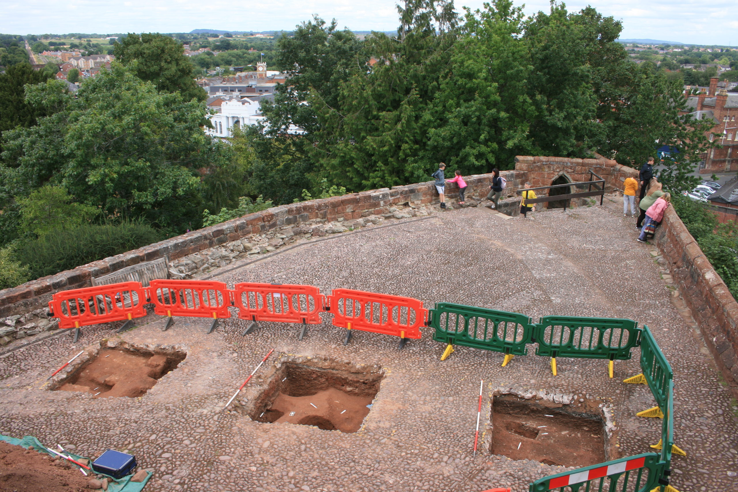
With the excavation report on the third and final season of excavation which the CST has funded now published on our website, project lead Dr Nigel Baker looks at what has been achieved since the first work in 2019 to now.
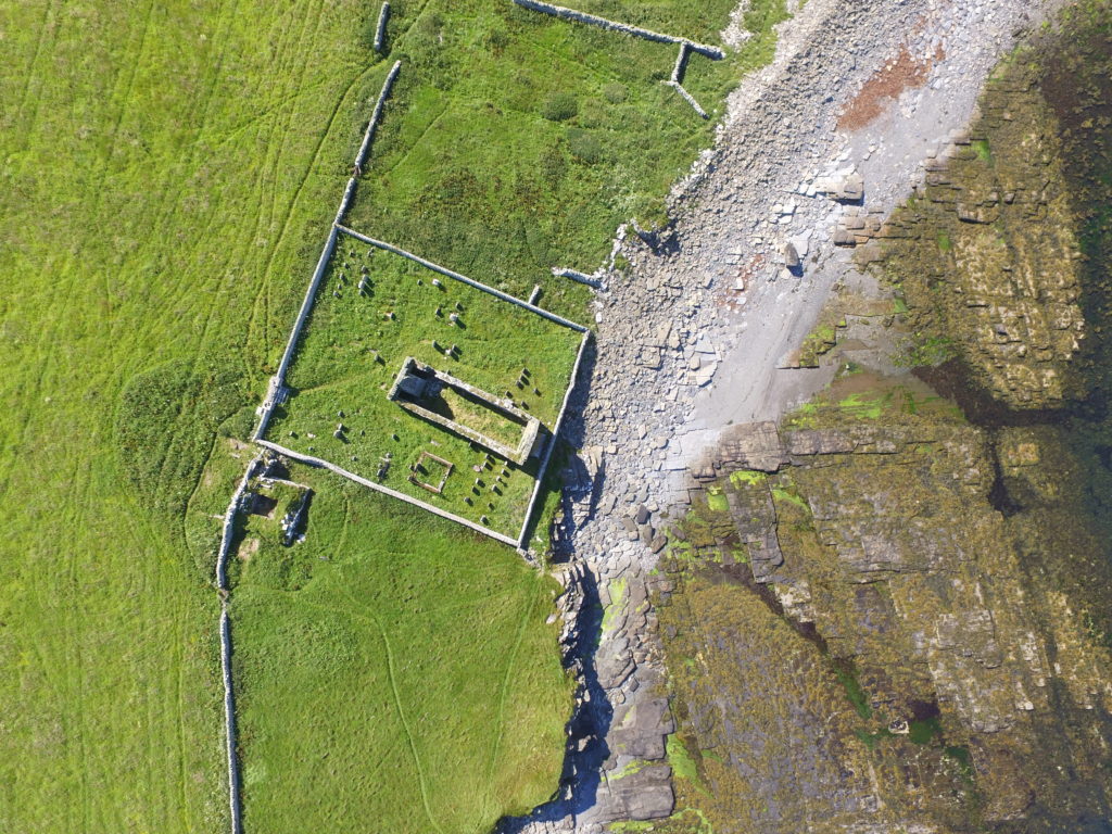
Just over a century ago Shrewsbury Castle began a new phase in its long life. In 1925 its principal surviving building, having been in use as a private dwelling since the castle was finally de-munitioned in 1686, became the meeting hall of Shrewsbury Borough Council, set in extensive landscaped gardens covering the remains of the motte and inner bailey, the outer bailey having (mostly) disappeared beneath the growing town by c.1300. Shrewsbury Castle remained more or less untouched by archaeology for the remainder of the 20th century. This changed in 2019 with the award by the Castle Studies Trust of a grant for a season of geophysical survey and excavation in the inner bailey. Following permission from Shropshire Council, the site owners, and Historic England, its legal guardians, the work took place in May and July 2019, the geophysics by contractors Tiger Geo and the excavation team made up of experienced local volunteers and staff and students of University Centre Shrewsbury. The results were unexpected.
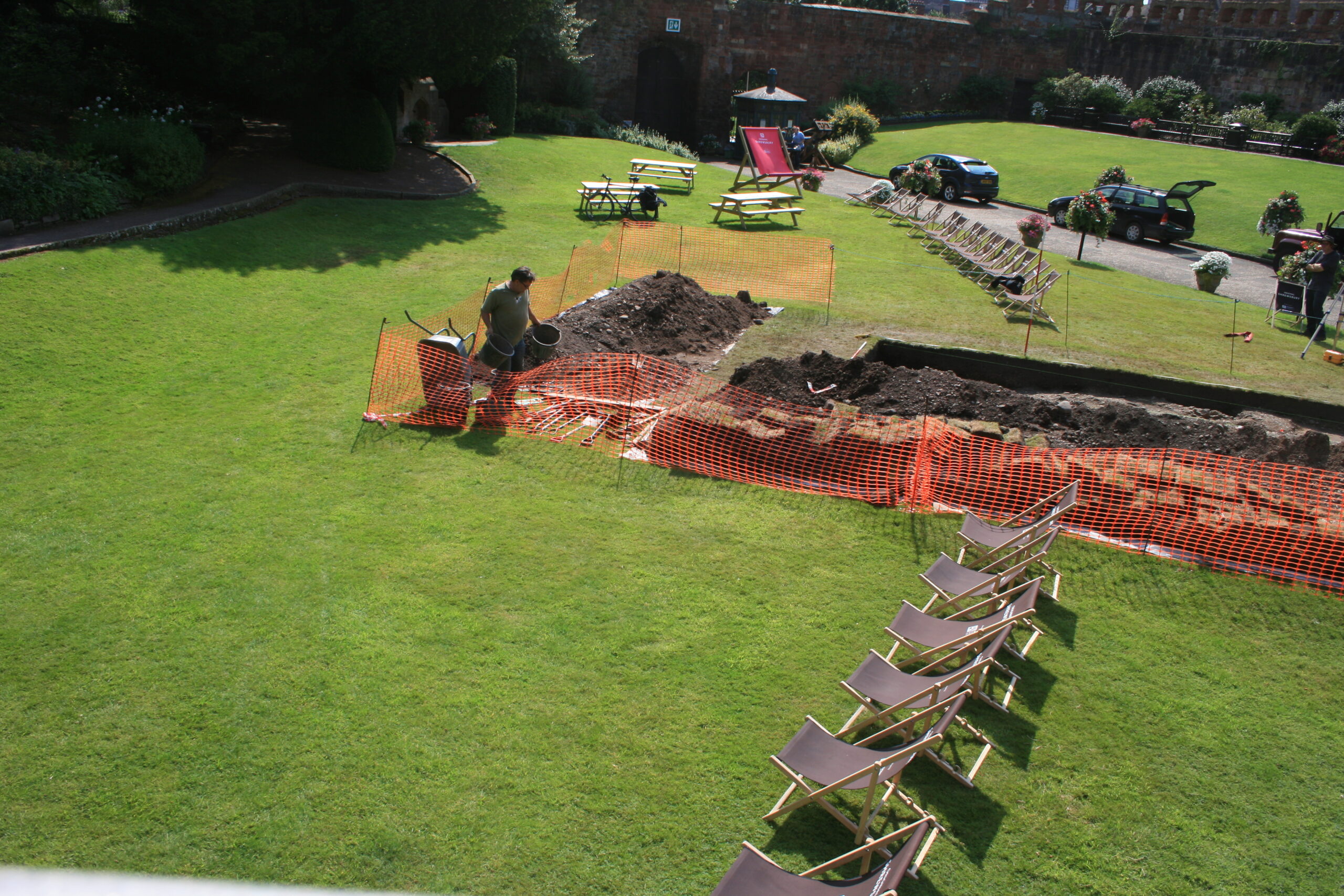
Shrewsbury Castle Excavation 2019 showing the width of the ditch around the motte using deckchairs (copyright Dr Nigel Baker)Arrow heads found in Shrewsbury Castle Motte Ditch (copyright Dr Nigel Baker)
Immediately under the turf was natural glacial gravel: the top of the hill on which the castle had been built; the ground surface had been lowered sometime in the past, removing nearly all archaeological remains. This was almost certainly the work of the young Thomas Telford who, from 1786 to 1790, lived in and ‘restored’ the castle for its owner, Sir William Pulteney, M.P. for Shrewsbury. However, archaeological strata were found to have survived within cuts into the natural gravel, and two of these were of major significance. The first was the edge of a previously-unknown ditch around the base of the motte. Medieval cooking-pot sherds of late 11th-13th-century date were found in its lowest excavated layers, along with two armour-piercing crossbow quarrel heads. The second significant find was of a pit containing in its fill a piece of decorated bone and two types of pre-Conquest (Saxon) pottery: Stafford-type ware, distributed widely across the emerging towns of the region and already well represented in Shrewsbury; and a limestone-tempered fabric, TF41a, never before seen in Shrewsbury, which had been made in the Gloucester area and probably imported up the Severn. This confirms that there was pre-Conquest activity on the site of the castle, and, along with the Domesday evidence that there was a church of St Michael there by 1086, may point in the direction of a high-status pre-Norman presence on this tactically-significant site controlling access to the ancient borough.
Shrewsbury Castle Excavation 2020 (copyright Dr Nigel Baker)
Excavation resumed in the autumn of 2020 with a trench seeking a sample profile through the west rampart of the inner bailey. This turned out not to be medieval in date. Both the west and the north rampart were probably created as part of Thomas Telford’s landscaping work in 1786-90. But, intriguingly, below the west rampart there was no sign within the trench of the natural hilltop gravel found close by in 2019 at a depth of just a few centimetres. The explanation may be that the bailey was enlarged westwards between the Norman period and the later medieval period, by dumping soil and levelling-up behind a new curtain wall.
Shrewsbury Castle Excavation 2022 on the motte top (copyright Dr Nigel Baker
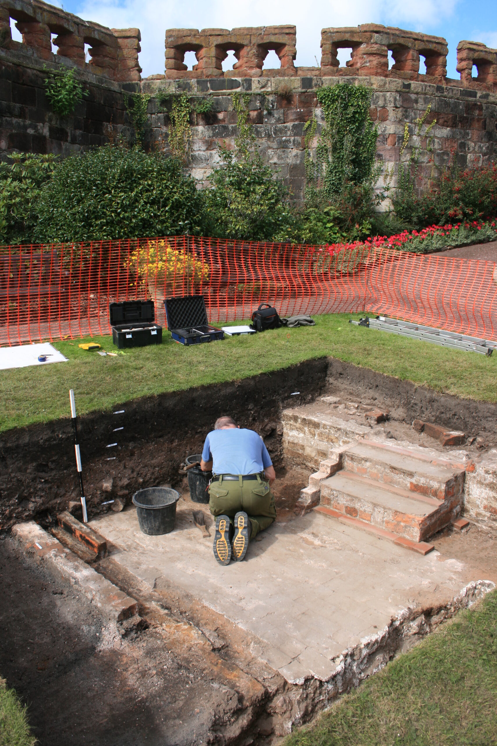
The final season of excavations took place in 2022 on the top of the motte, and outside the north curtain wall. Telford is known to have demolished ruined medieval buildings on the top of the motte and replaced them with the surviving two-storey Gothic summerhouse there. Excavation showed that Telford’s activities had, again, removed most of the archaeology but that the foundations of early medieval timber buildings (beam slots, a post pad, post holes) survived where they had been cut into the motte material. No definite trace was seen of the ‘great wooden tower’ which is documented on the motte top until its collapse in 1269-71.
New light was also shed on the motte by vegetation clearance on its south side, revealing for the first time remains of buildings incorporated in the masonry of the retaining walls. This work was undertaken on behalf of Shropshire Council for a new conservation-management plan, currently at consultation stage, which includes photogrammetric surveying of all the castle structures. This permanent stone-by-stone record not only forms the basis for the next vital stage of work – identifying and specifying long-needed repairs – it also offers new archaeological insights, including the identification of the probable primary sandstone rubble fabric of the curtain walls. This was in turn followed by some research carried out by Jason Hurst on Civil War musketry damage in 2023 (Potential shot damage at Shrewsbury Castle – Castle Studies Trust Blog) . And now, the process of publishing this body of new archaeological, architectural and historical information is just beginning…
Delayed by the pandemic, at long last our 2020 project to see if the Wirk, in the Orkneys, was a castle is now complete. Project leads Sarah Jane Gibbon & Dan Lee look at what they found.
A programme of archaeological fieldwork funded by Castle Studies Trust was undertaken at The Wirk, on the island of Rousay, Orkney by the Orkney Research Centre for Archaeology during 2020-21 (UHI Archaeology Institute). The Wirk comprises the remains of an upstanding stone-built tower with the site of an adjoining hall range to the east, which are stylistically considered to be 12th century in date. The site was part of a high-status Norse settlement with a medieval chapel nearby (below the present St Mary’s kirk) and Norse hall further to the south at Skaill (Research projects – Landscapes of Change: Archaeologies of the Rousay Clearances & the Westness Estate (uhi.ac.uk)). The project aimed to characterise The Wirk with geophysical survey, undertake evaluation excavation to assess the hall and recover material suitable for radiocarbon dating.
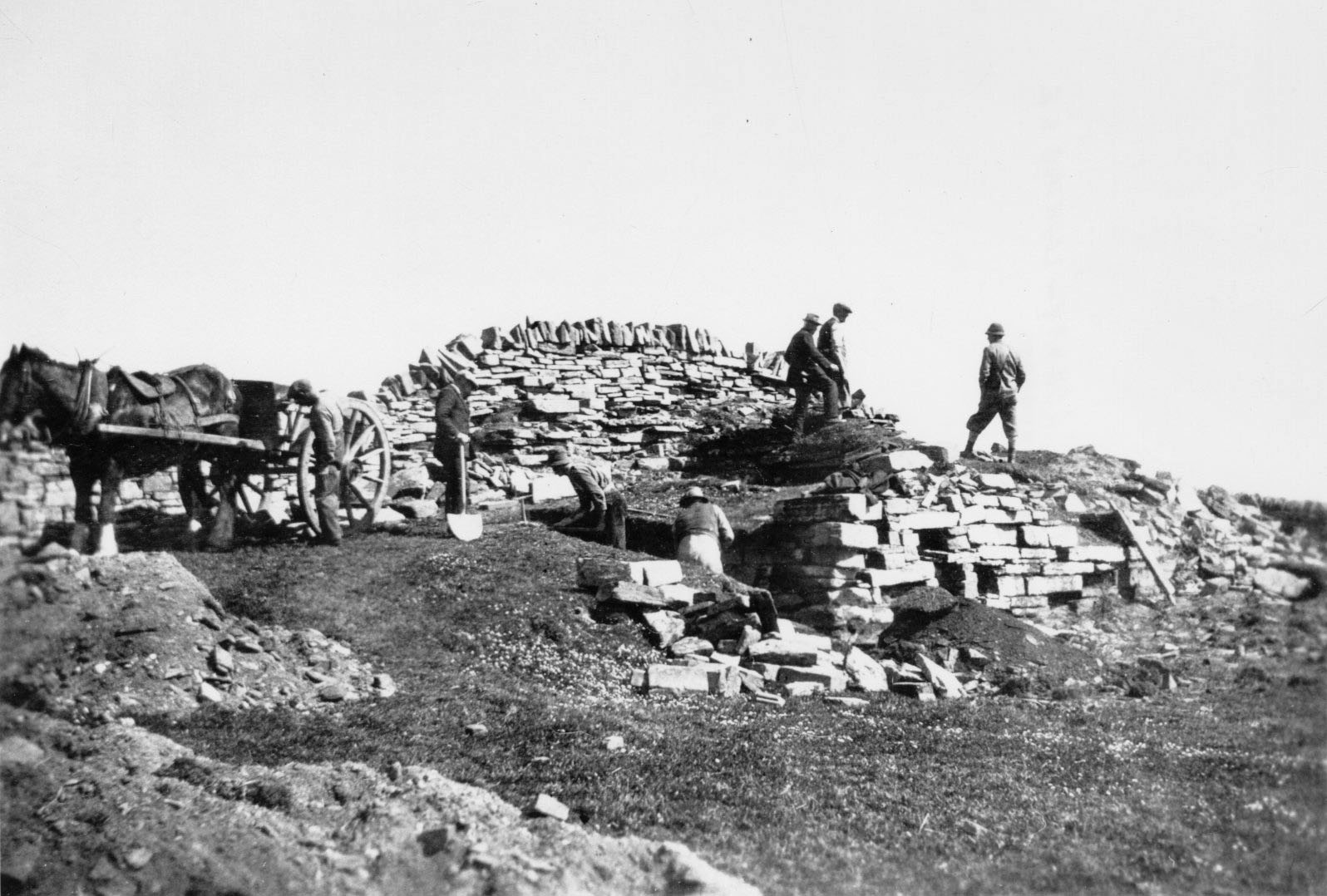
1. Clouston’s excavations at The Wirk in the 1920’s showing investigations in the tower (Credit: Orkney Library & Archive, used with permission).
The Wirk was excavated in the 1920s by J. S. Clouston, who had excavated at other Norse castle sites in Orkney. Later dates have since been suggested for the The Wirk (16th century), however the date of the buildings, their function and the relationship between the tower and range remained open to debate. Clouston’s excavations focused on the tower and exposed the remains of a hall and ancillary buildings upslope to the east. He made a detailed plan of the site showing the tower and hall. Few finds were recovered but they did include a highly decorated stone finial now on display in Tankerness House Museum, Kirkwall. The impressive tower survives today, but the hall is not currently visible in the neighbouring field.
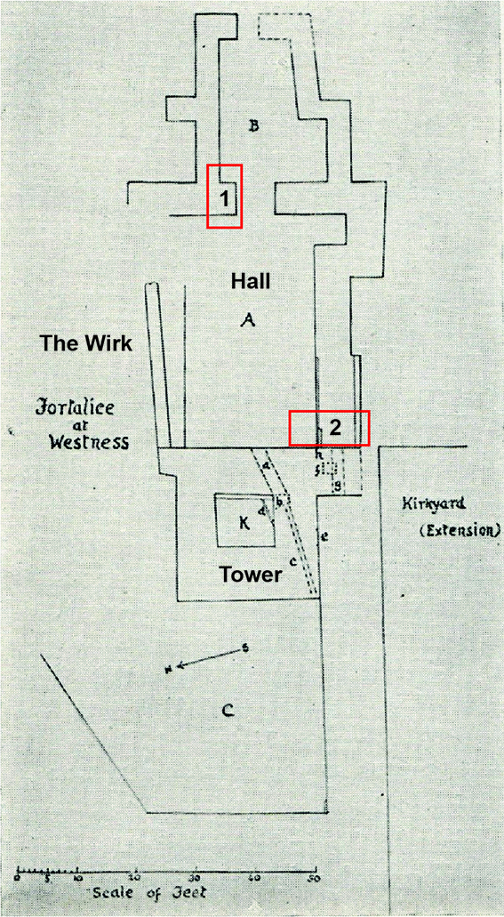
1. Clouston’s plan following his excavations, detailing the hall to the east of the tower, with Trenches 1 and 2 (after Clouston 1931, Early Norse Castles)
Geophysical survey in 2020 was used to characterise the buried remains of the hall range and identified additional features in the vicinity (Geophysical survey at The Wirk reveals buried walls of the hall – Castle Studies Trust Blog). Evaluation excavation in two trenches in 2021 targeted the eastern hall range and located substantial wall footings just below the ground surface (part of an ancillary building in Trench 1 and the southern external wall of the hall in Trench 2). Excavations concluded that the tower and hall range were built at the same time (contra some earlier interpretations by Clouston). Clouston just exposed the footings of the hall walls, without fully excavating around them, but his plan of the site was proved to be very accurate. The hall may have had raised wooden internal floors, certainly in the lower western part, perhaps supported by an internal scarcement (although excavations were too limited to be conclusive).
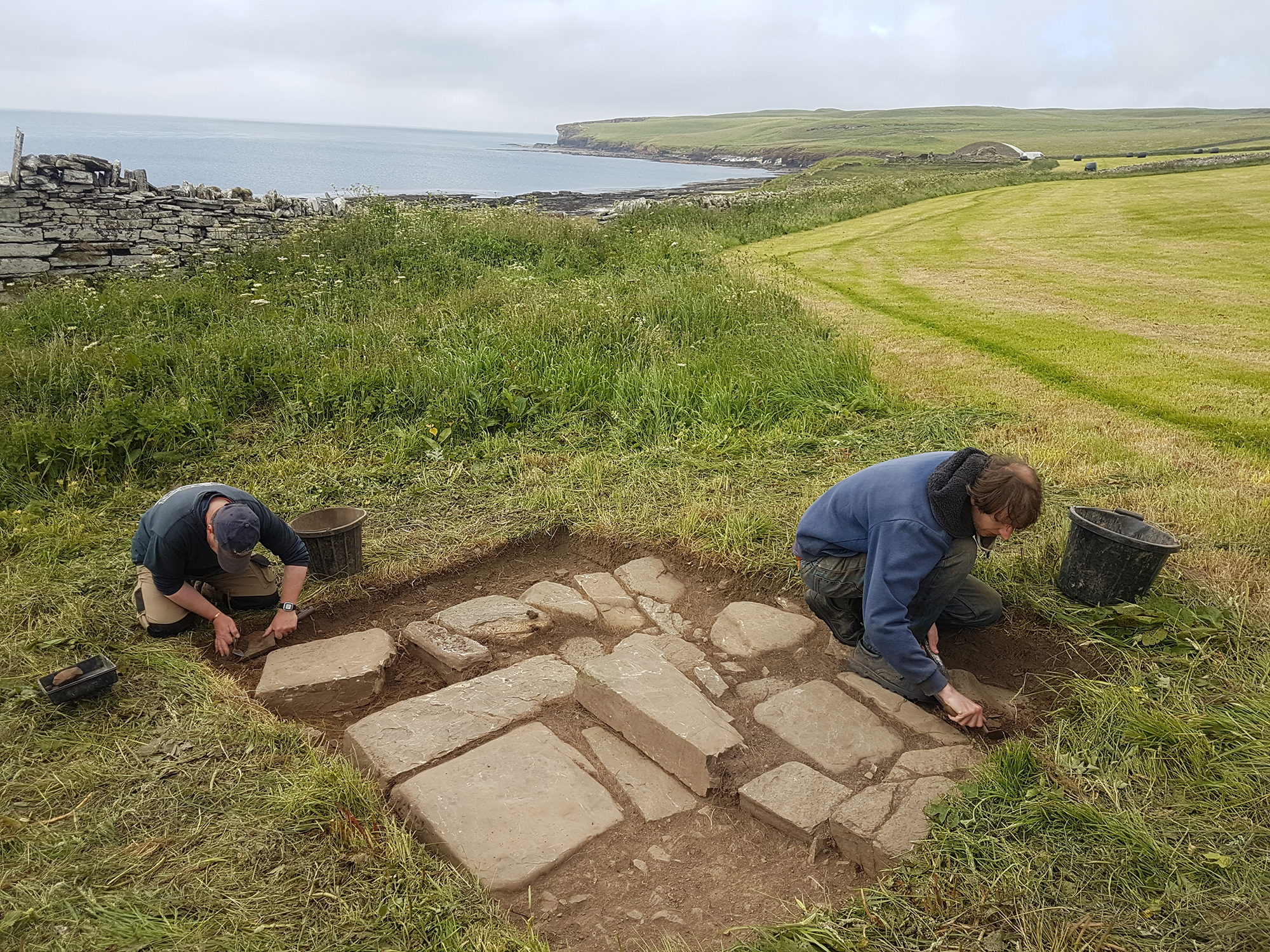
Excavations in Trench 1 exposed the wall footing of the ancillary buildings at the eastern end of the hall (Credit: Dan Lee)Excavations in Trench 2 exposed the substantial southern wall of the hall (Credit: Dan Lee)
A significant assemblage of c.13th century worked and moulded red sandstone was recovered from Trench 2 nearest the tower. The red sandstone is interpreted as ecclesiastical in origin and likely to have originated from the former medieval kirk nearby, rather than the hall. The Wirk was unlikely to have been an ecclesiastical building due to the raised floors and association with the tower. Radiocarbon dates from material (charred grain) found in deposits abutting the southern external wall of the hall returned Late Iron Age dates (Pictish period mid-7th to mid-8th century AD). This material is most likely derived from the disturbance of earlier activity at the site during the construction of the hall, hinted at by the surrounding geophysical anomalies, rather than dating the hall itself. It was concluded that the tower and hall are contemporary and likely to be 12th century in date, based on architectural style and stratigraphic relationships observed during the excavations.
In 2020, the Castle Studies Trust funded Dr Karen Dempsey to undertake an innovative new line of research in castle studies, namely to explore the use of plants in castles in medieval Ireland. In this article, Karen explains what she and her colleague Dr Fiona MacGowan discovered.
Over the course of this Pandemic many people have a newfound or renewed appreciation for the green world that we live in. This might take material form by growing potted plants at home and if fortunate caring for a garden space of your own or somewhat less tangibly, the contemplation of changing seasons in your local park. The (anecdotal) health benefits we might feel from these activities are increasingly underscored by health professionals who assure us of the roles of green spaces in wellbeing. This connection is not a modern phenomenon – plants (and gardens) played a significant role in the diet, healthcare and spirituality of people living as part of castle households.
‘Sowing Seeds of Interdisciplinary Work’, the Castle Studies Trust funded project, showed how relict plants can deliver new insights into everyday life at medieval castles. Relict plants – understood to be the descendants of plants grown, cared for and used by (medieval) people – were identified through botanical surveys at four geographically diverse but culturally similar medieval castles: Adare, Co. Limerick, Castleroche, Co. Louth, Carbury, Co. Kildare and Castlecarra, Co. Mayo (as detailed in my previous blog post). As an initial step in researching relict plants, particular attention was paid to archaeophytes, those plants which arrived in Ireland pre-1500 CE. I believed that these plants may have participated in the various colonisation processes of the twelfth century. Their introduction could be linked to new gardening and other health practices especially those related to novel plant medicines which were emerging across Europe at this time but were perhaps previously unknown in Ireland.
Relict Plant Findings
Botanical surveys began during mid-2020 in the very wet months of June and July after a hot May.
Next site on our Relict Plants project @CastleStudies is Castle Carra Co.Mayo. Built by Adam de Staunton c. 1240. Castle with hall and chamber, with the vill, parish church and abbey c. 1km east. pic.twitter.com/yJISGh7DiL
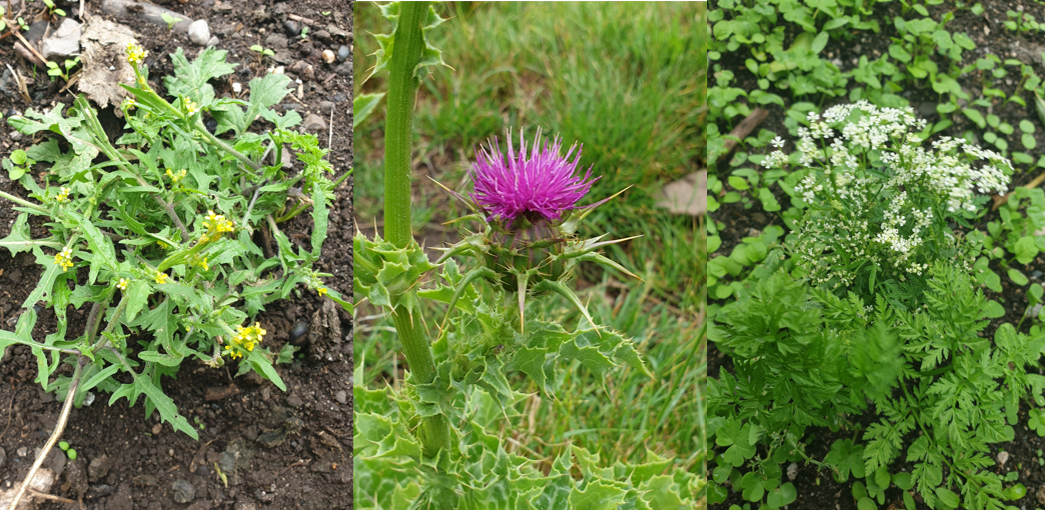
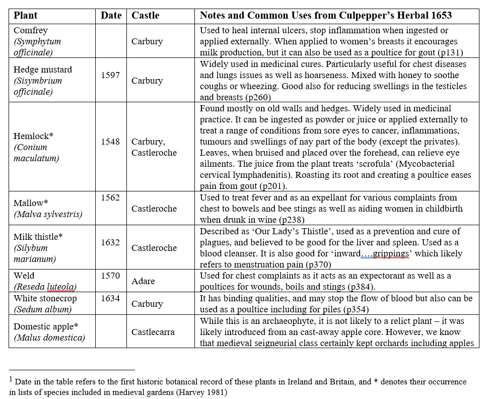
Over the course of the survey eight archaeophytes were revealed (Table 1) as well as a range of rare and common native plants. You can read Dr MacGowan’s botanical report here. These findings are significant: four of the eight plants were historically recorded as present in medieval gardens. The plants – comfrey, mallow, milk thistle and hedge mustard – are widely recognised as having medicinal properties (Fig 1). They feature in medieval recipes, continued as part of the tradition of plant medicine captured in Culpepper’s Herbal of 1653 and some, like milk thistle, remain in use today (see Table 1).
Figure 1 Milk thistle at Castleroche; Hedge mustard and Hemlock (Conium maculatum) at Carbury; (pictures by Dr MacGowan)
Table 1 List of Archaeophytes and neophytes at four selected castles in Ireland[1]
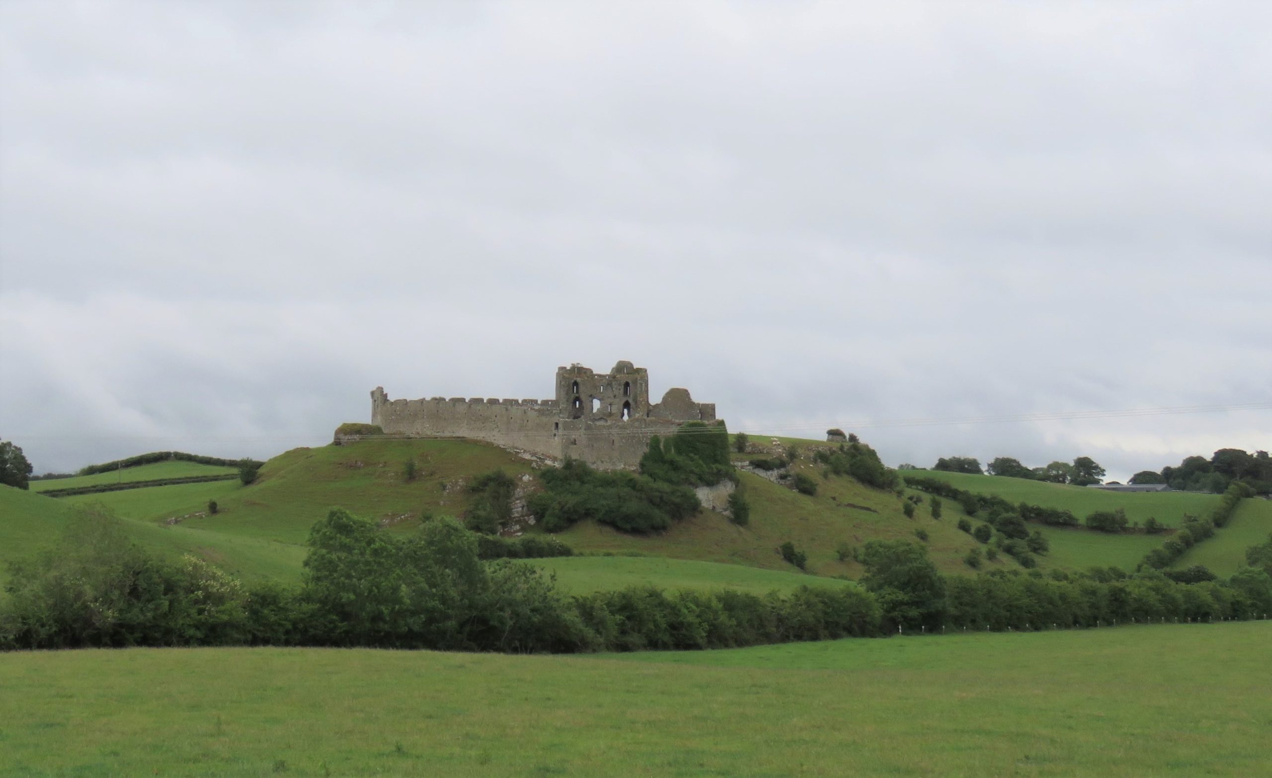
Figure 2 Castleroche, Co. Louth, sited for maximum spectacle across a locally significant elevation at the foothills of the Mourne Mountains
Relict Plants in their Castle Contexts
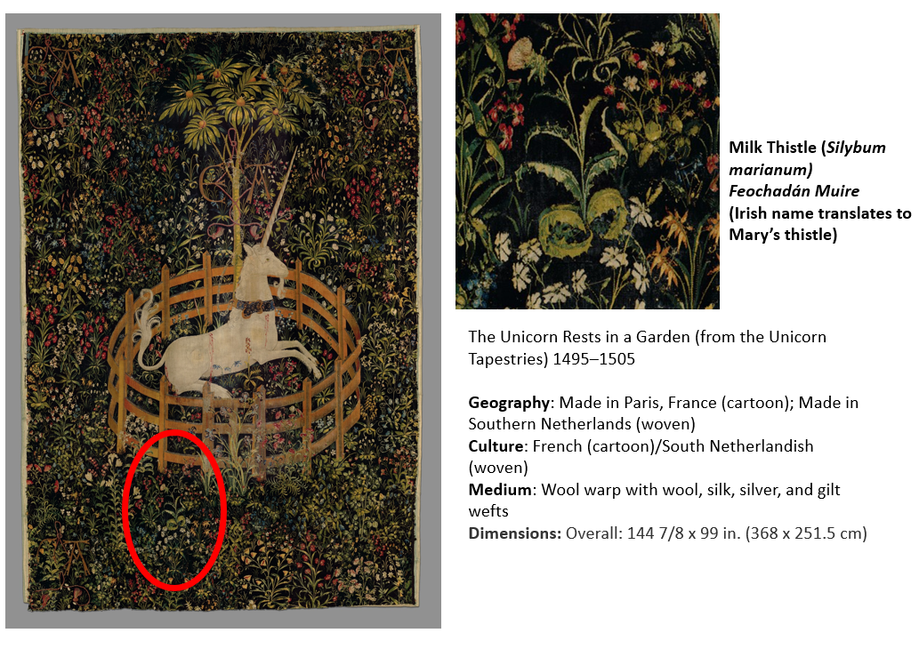
Castleroche was the first site surveyed for our fieldwork. It is spectacularly situated on a locally significant rocky outcrop, framed to the north by the foothills of the Mourne Mountains (Fig 2). The castle has been long understood as a defensive site, believed to have been positioned as authoritative infrastructure to exercise territorial control. Its’ patron, Roesia de Verdun (d.1247) is renowned as the only historically attested woman to have founded a castle in thirteenth-century Ireland This castle while now in ruins was once a busy place with an associated village replete with a weekly market and annual fair. I considered this site to have great potential for relict plants given that historic sources noted the presence of ‘gardinia’ (gardens associated with castles) coupled with the high-status of its’ patron who had a considerable number of estates across England and France. These connections must have given her and her staff access to, and knowledge of, different cultural traditions including gardening and medicinal practices. We were delighted to identify three archaeophytes: Hemlock (Conium maculatum), Mallow (Malva sylvestris) and Milk thistle (Silybum marianum). Milk thistle is a particularly important identification, it is very rare in Ireland and Britain. For medieval people, it was culturally and symbolically tied to the Virgin Mary as well as understandings of fertility and motherhood (Fig 3). This allows us to reconsider the idea of Castleroche only as a frontier site; perhaps there was a diverse resident population for much longer than previously understood. Their health concerns may be represented by the continued occurrence of these plants. Exploring the botanical legacy of Castleroche adds further layers to the story of this complex site.
Figure 3 The Unicorn Rests in a Garden (from the Unicorn Tapestries) 1495–1505. https://www.metmuseum.org/art/collection/search/70007568Figure 4 Carbury, Co. Kildare: a multiperiod castle complex comprises a motte, an early masonry focal building with later additions including an Elizabethan extension crowned with multisided cut stone chimneys
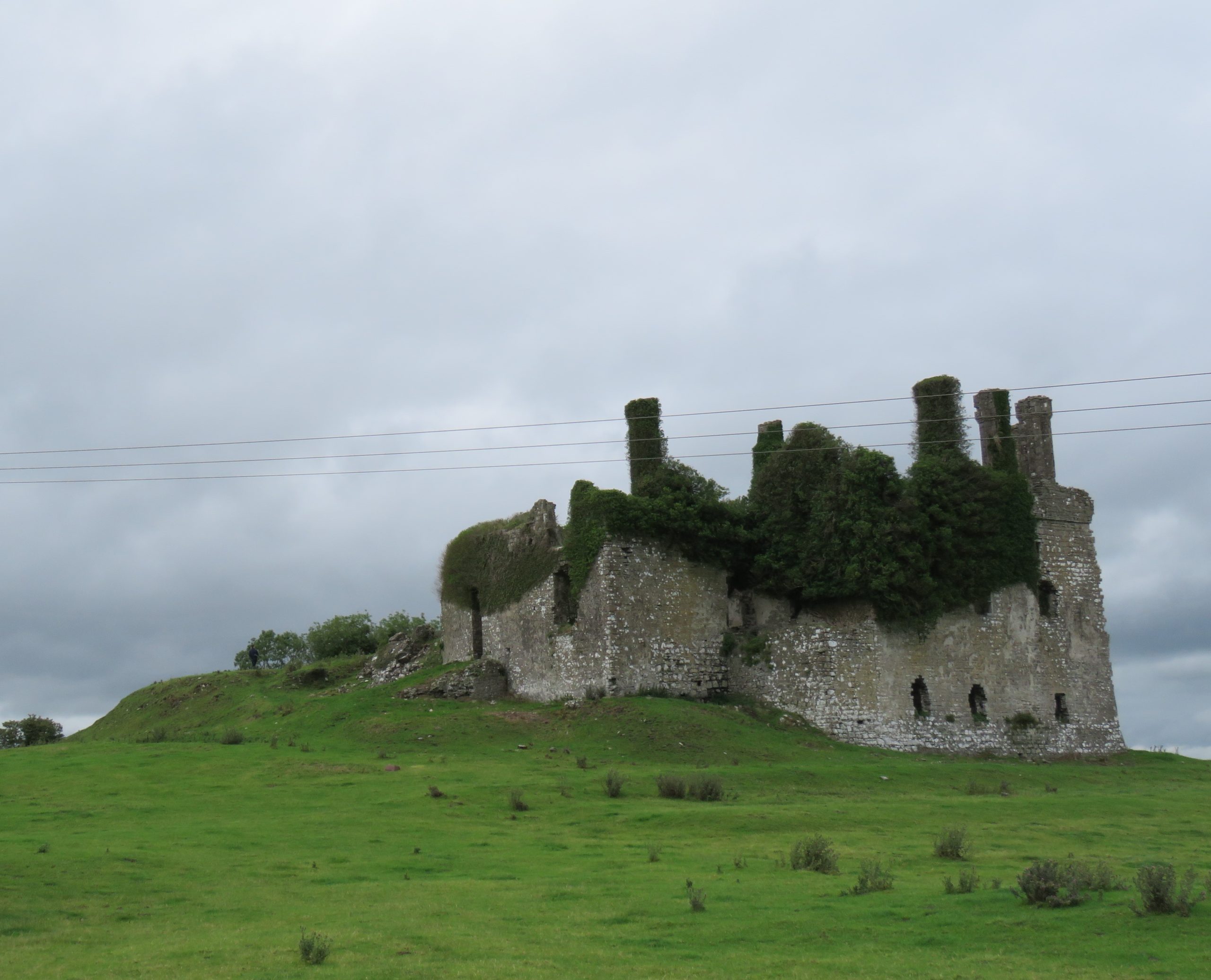
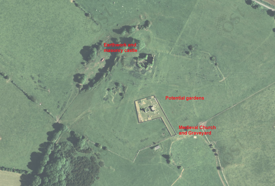
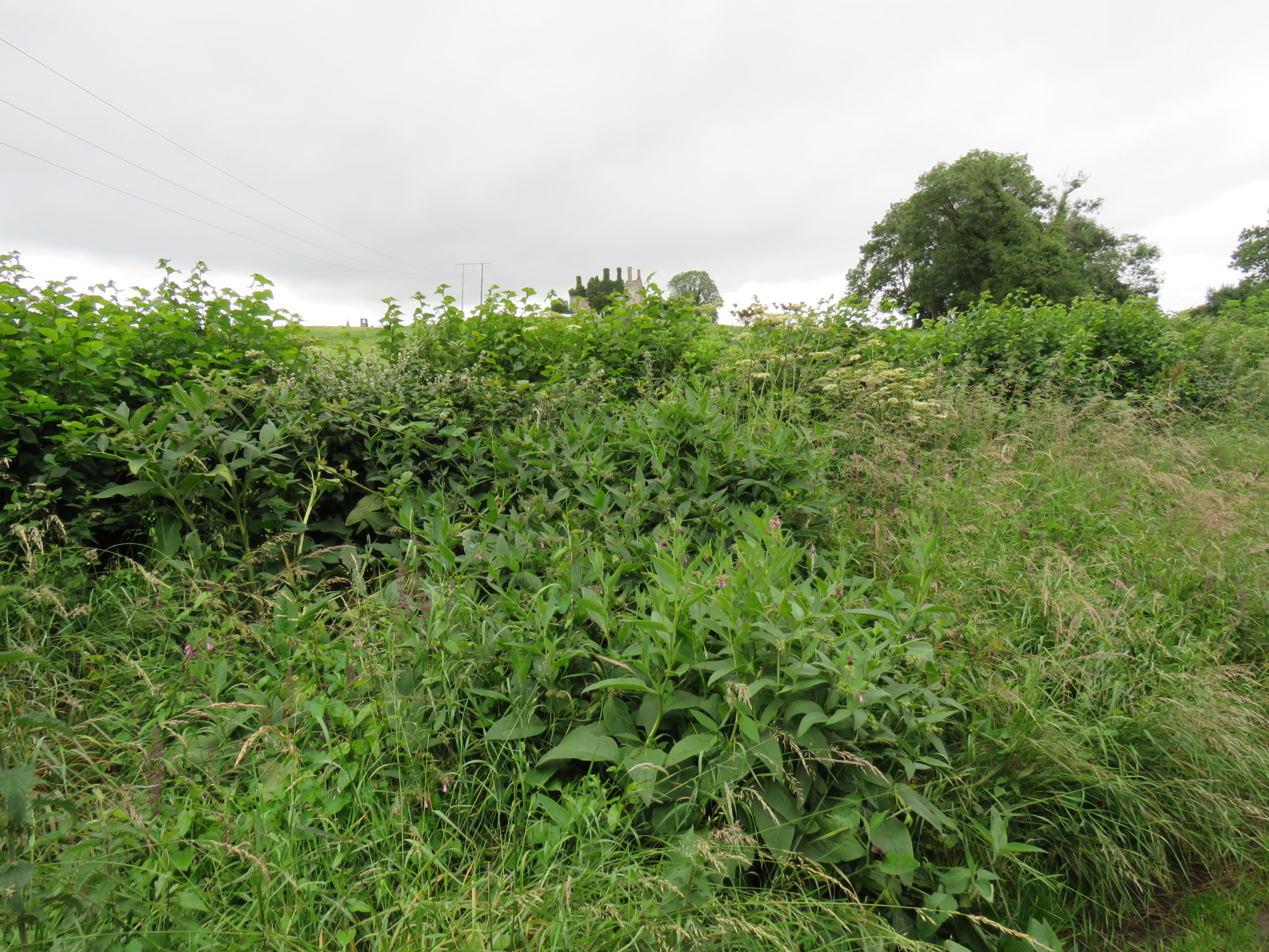
A less well-known castle but equally deserving of attention is the medieval settlement at Carbury (Fig 4). This multiperiod complex comprises an earthwork castle, a twelfth or very early thirteenth-century masonry castle with later additions including an Elizabethan extension and related gardens (Fig 5). Carbury is entangled with generations of nobles. It acted as a central node in shifting political allegiances and dynastic disputes within the territory of Leinster. The longevity in occupation of Carbury is interesting, it attests – at least in part – to its suitability as a residence. Is this reflected in the immediate castle landscape? Is there a possibility that the early-modern gardens here overlay medieval predecessors? Four archaeophytes were found at Carbury: Hemlock, Comfrey (Symphytum officinale), Hedge mustard (Sisymbrium officinale) and White stonecrop (Sedum album), three of which were adjacent to or within the masonry castle and the fourth – Comfrey – which was found within the hedgerow that forms the historically significant boundary to the castle landscape (Fig 6). These plants are not uncommon, but perhaps their relative ubiquity is reflected in their suitability for use within different plant medicine traditions. Comfrey is particularly notable, known as knitbone, it was widely used as a healing poultice for broken bones throughout medieval medical texts. Pharmacologically, this plant contains allantoin, which promotes the creation of new cells and healing of connective tissue. Relict plant studies at Carbury allows us to reflect on how this place was a home to many different generations of people who participated in caring roles (for plants and people) whilst also being a locus for political tensions.
Figure 5 Aerial Imaging of Carbury Castle with evidence for potential gardens surrounding the castle.Figure 6 Comfrey (Symphytum officinale) and Hedge woundwort (Stachys sylvatica) noted among other medicinal plants in hedgerow with Carbury Castle in background
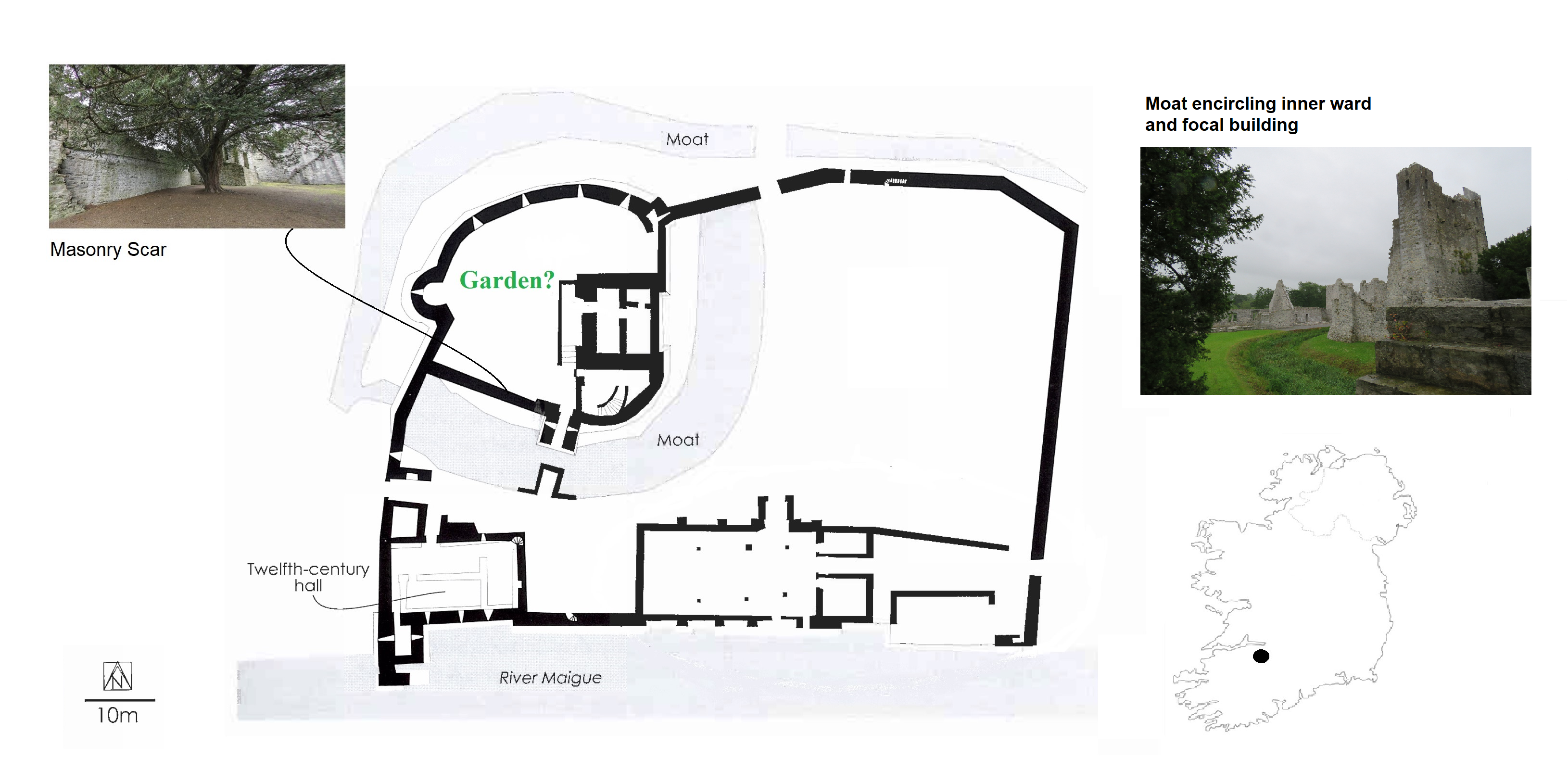
With these exciting discoveries at both Castleroche and Carbury, we were very hopeful that the survey at Adare Castle would be equally rewarding. Adare was an important castle as the caput of the Geraldine family. Unlike the other sites, it has been subject to major study including detailed historical and archaeological investigation. Adare Castle was constructed on a pre-Norman power centre from which the castle emerged as a large D-shaped earthwork with a surrounding large ditch and river-fed moat (Fig 7). This later formed the inner ward, which was further enclosed by an external wall to the north-west with a single mural tower and a gatehouse to the south. The outer court is enclosed by masonry walling which is augmented by a ditch to the north and west. At Adare, the grounds are intensely managed, with manicured lawns and ongoing pesticide use (Fig 8). Unfortunately, this was particularly pronounced in the inner ward, the area I have suggested was likely to have contained an enclosed garden. Disappointingly, only one archaeophyte was identified: Weld (Reseda luteola). This dyeplant was predominantly used to give a bright colourfast yellow but also used medicinally to treat chest complaints. A number of neophytes – those plants whose introduction post-dates 1500 CE – were found in the associated areas surrounding the castle as detailed by Dr MacGowan. Species such as Himalayan pheasant berry (Leycesteria formosa) were identified, indicating that relict plants studies can also illuminate the afterlife of the castle when it played a role as a romantic ruin in the eighteenth-century landscape of Adare Manor. This shows the potential for relict plants studies to add layers to castles stories across their life histories.
Figure 7 Plan of Adare Castle with possible garden (after Dempsey 2021 and O’Keeffe 2015)Figure 8 Adare Castle, inner ward subject to extensive pesticide use
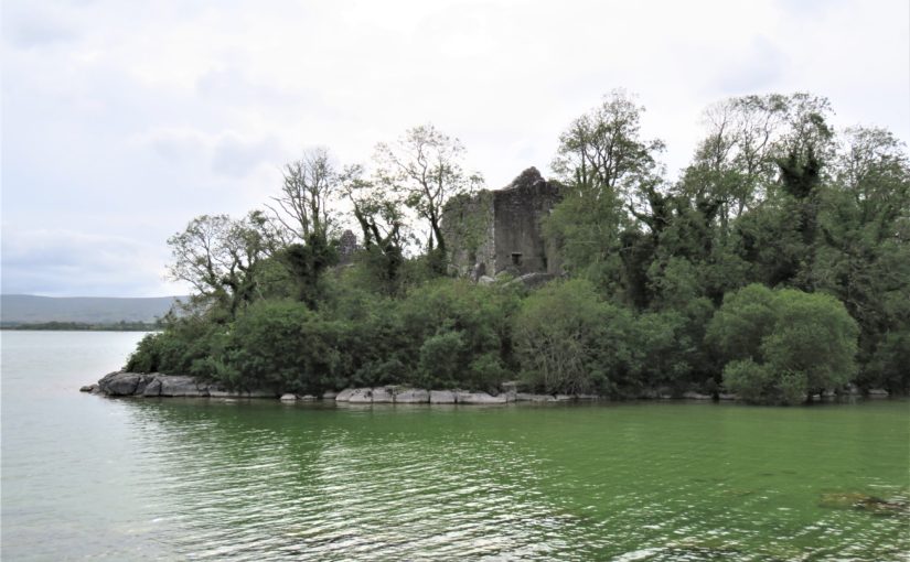
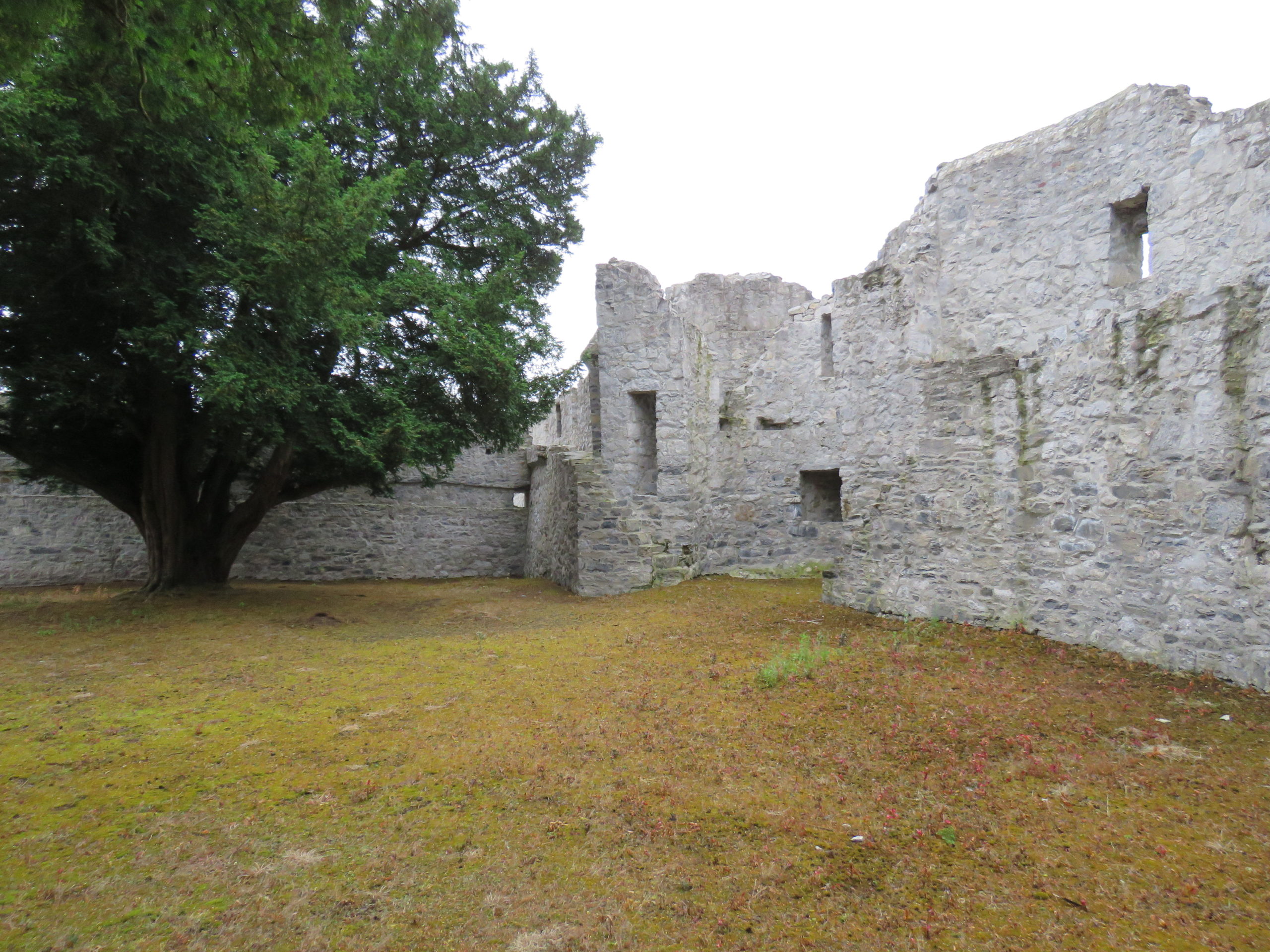
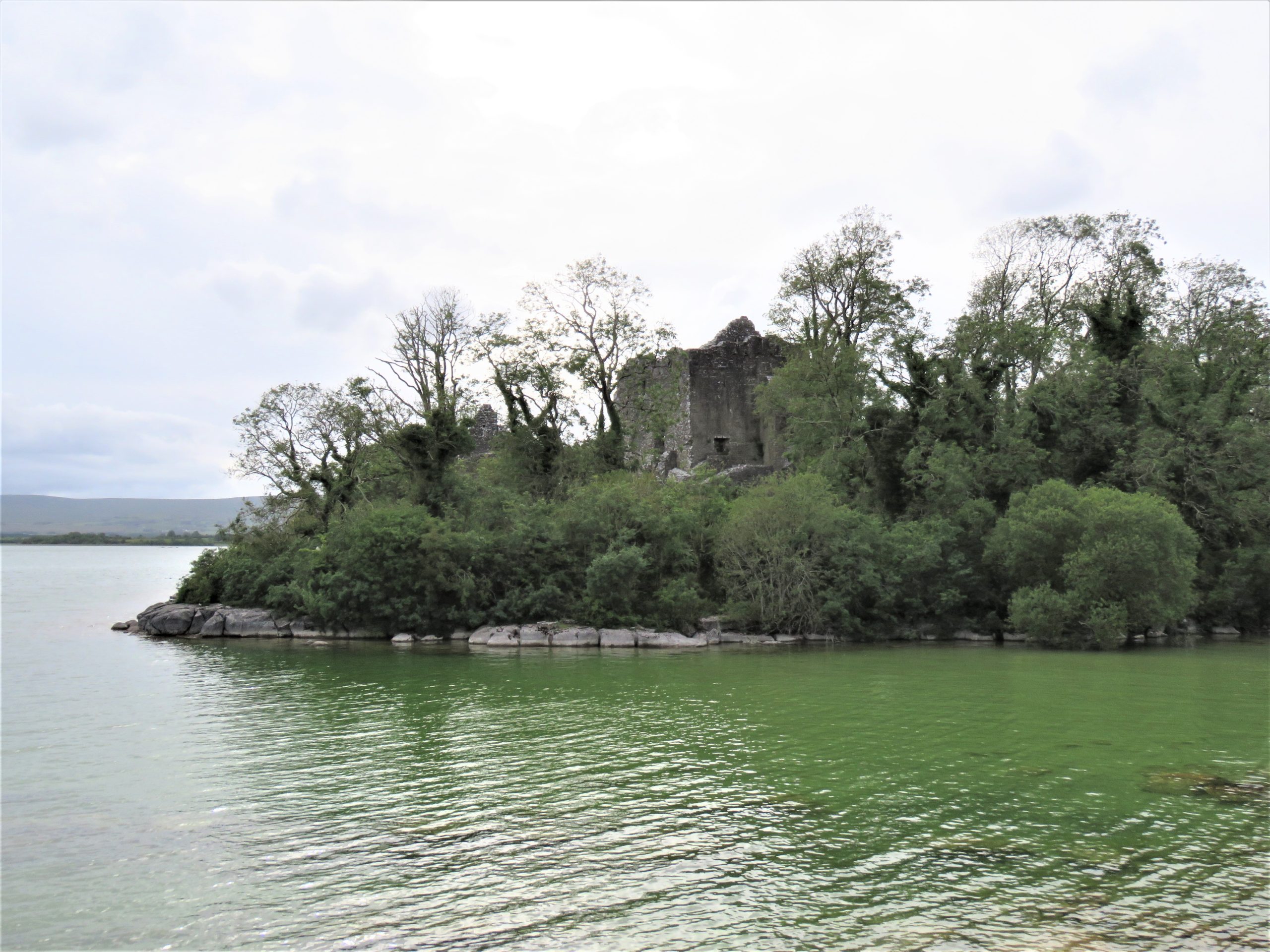
The final site, Castlecarra, falls lower down the social hierarchy of medieval Ireland than the other three castles but it was still an important baronial residence (Fig 9). It is situated on the eastern shore of Lough Carra. The castle now comprises a large three-storey focal building set within a very compact enclosure which is a later, potentially fifteenth-century addition. The castle was constructed as one part of the c. 1236 Anglo-Norman territorial expansion into Connacht. This site, like the others, has a long history of occupation. An early-modern (sixteenth-century?) house was constructed c. 125m NE of the castle, and the surrounding landscape appears to have been remodelled to suit a new tradition of landscape gardening which included a ha-ha and tree-lined avenue of Hornbeams (Carpinus betulus) (Fig 10). Archaeophytes were not recorded at Castlecarra but numerous native species as well as neophytes were present. This absence is remarkable but perhaps native plants at Castlecarra served the castle household needs. For example, Purging buckthorn (Rhamnus catharticus) was identified. This plant is native but rare in Ireland, and it was used medicinally as a purgative, as the name suggests. The botanical profile of Castlecarra leads to further questions around the transmission and sharing of medicinal and plant knowledge.
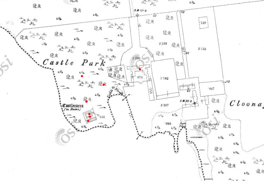
Figure 9: Castlecarra, Co. Mayo on shore of Lough CarraFigure 10 Castlecarra, Co. Mayo: a multiperiod site with medieval castle that forms part of the landscape of an early modern (c. later 16th / early 17th house). Ordnance Survey Map 1925, Castlecarra to lower left and historic home including outbuildings and gardens centrally placed. https://maps.archaeology.ie/HistoricEnvironment/
Research, Heritage Futures and Reflection
One of this project’s aims was to test and refine the methodologies of relict plant studies for medieval castles. In Ireland there are currently 96 species recorded as archaeophytes (but with no established dates of introduction). Despite the findings of some notable plants, the overall numbers of archaeophytes at the castle sites in ‘Sowing Seeds’ seemed low. Of course, our findings may have been constrained by single survey days, unseasonal weather as well as conservation and management issues – both present-day and historic. Future work is necessary. It is important that sites have the benefit of multiple visits across a wider seasonal survey period. Nevertheless, the baseline botanical surveys of this project will be of use for future research within and outside of castle studies. It has also revealed the need for a detailed survey of archaeobotanical evidence from excavations in Ireland to establish as far as possible exact introduction dates for particular plants.
Including a wider range of plants and castles over a longer time span would provide comparative material with a greater capacity to capture change over time. Neophytes were noted in the botanical surveys but not part of the research agenda for ‘Sowing Seeds’. Their occurrence at castle sites may be revealing of expanding connections with sixteenth-century colonising and trading practices beyond Europe. Later medieval towerhouses are of particular interest as they are often situated within less managed and therefore within potentially better-preserved landscapes. But equally, native plants should also be included. For example, self-heal (prunella vulgaris) and pellitory-of-the-wall (Parietaria judaica) occur widely and were both used as medicinally. It would be of great interest to compare and contrast different plants at castles whether native, anciently introduced or more recent. Consideration too could be given to the afterlives of medieval castles as romantic ruins as indicated at Castlecarra and Adare. This would develop a wider appreciation of the long lives of medieval castles that continue in dialogue with contemporary communities as heritage today. Relict plant studies enable castle studies to participate in emerging conversation around green heritage and climate change.
‘Sowing Seeds’ was a novel project – both conceptually and methodologically – I wanted to find a way to explore potential ‘green identities’ of castle households. Accessing the relationships medieval people may have had with their environments (as we might term it today) offers a different way of telling stories about the medieval past whose narratives are often caught into concerns of power, authority or control. By including botanical surveys of relict plants in castle landscapes, we have expanded further the multidisciplinary approach of castles studies. We can show how stories of castles are richly textured: populated by many people and plants over the course of their lives and beyond into their afterlives as romantic ruins and archaeological monuments. Doing this for the first time meant engaging with new material and unfamiliar sources from archaeology, history, and medical knowledge to heritage and folklore. This wide-reaching research methodology is a core strength of this project. It enables a dialogue between different disciplines that are traditionally separate or rarely integrated. These findings are a beginning: they encourage new avenues of future research on castles households relating to human-plant relations, plant medicine and related concepts of care. The results also invite conversations with heritage agencies regarding site management and conservation practices of both biodiversity and past vegetation. Rather than offering conclusive findings, we have revealed tantalising hints and a vast array of potential new avenues in which to take this research.
This research was generously funded by the Castle Studies Trust. Their support enabled new ideas to be explored. As an early career researcher being awarded a grant to undertake (potentially) interpretatively risky work is a wonderful opportunity.
Helpful commentary and feedback was received from two assessors whose insights improved this report.
Thanks to Dr Fiona MacGowan for participating in this research project and carrying-out the botanical surveys at the selected sites.
Thanks to the landowners of Castleroche, Castlecarra and Carbury, and the Office of Public Work who manage Adare, for access to the sites for this project.
[1] Dates in the table refer to the first historic botanical record of these plants in Ireland and Britain, and * denotes their occurrence in lists of species included in medieval gardens (Harvey 1981)
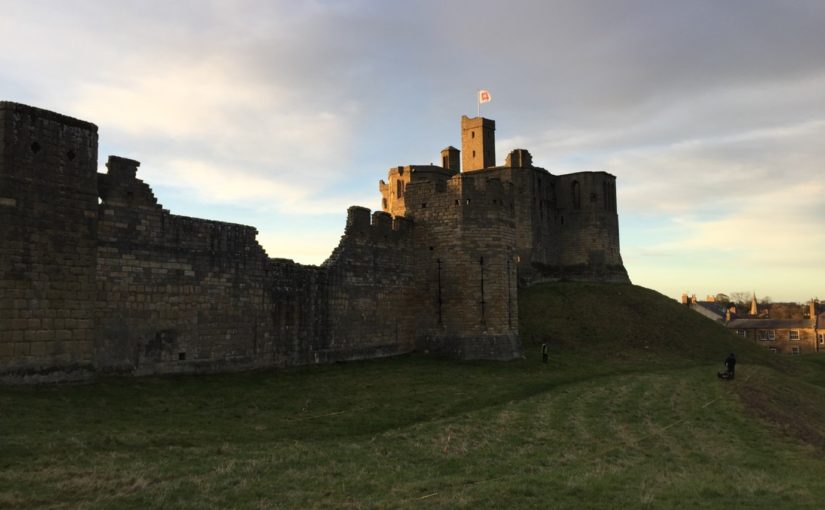
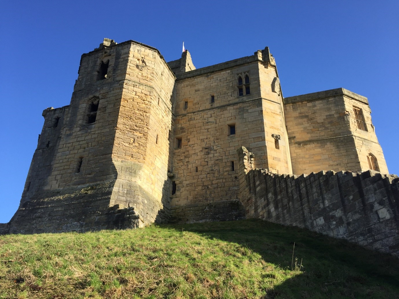
Dr Will Wyeth, English Heritage property historian and project lead on the two geophysical surveys the Castle Studies Trust funded on Warkworth Castle, looks at what the surveys reveal and equally importantly don’t reveal about the castle.
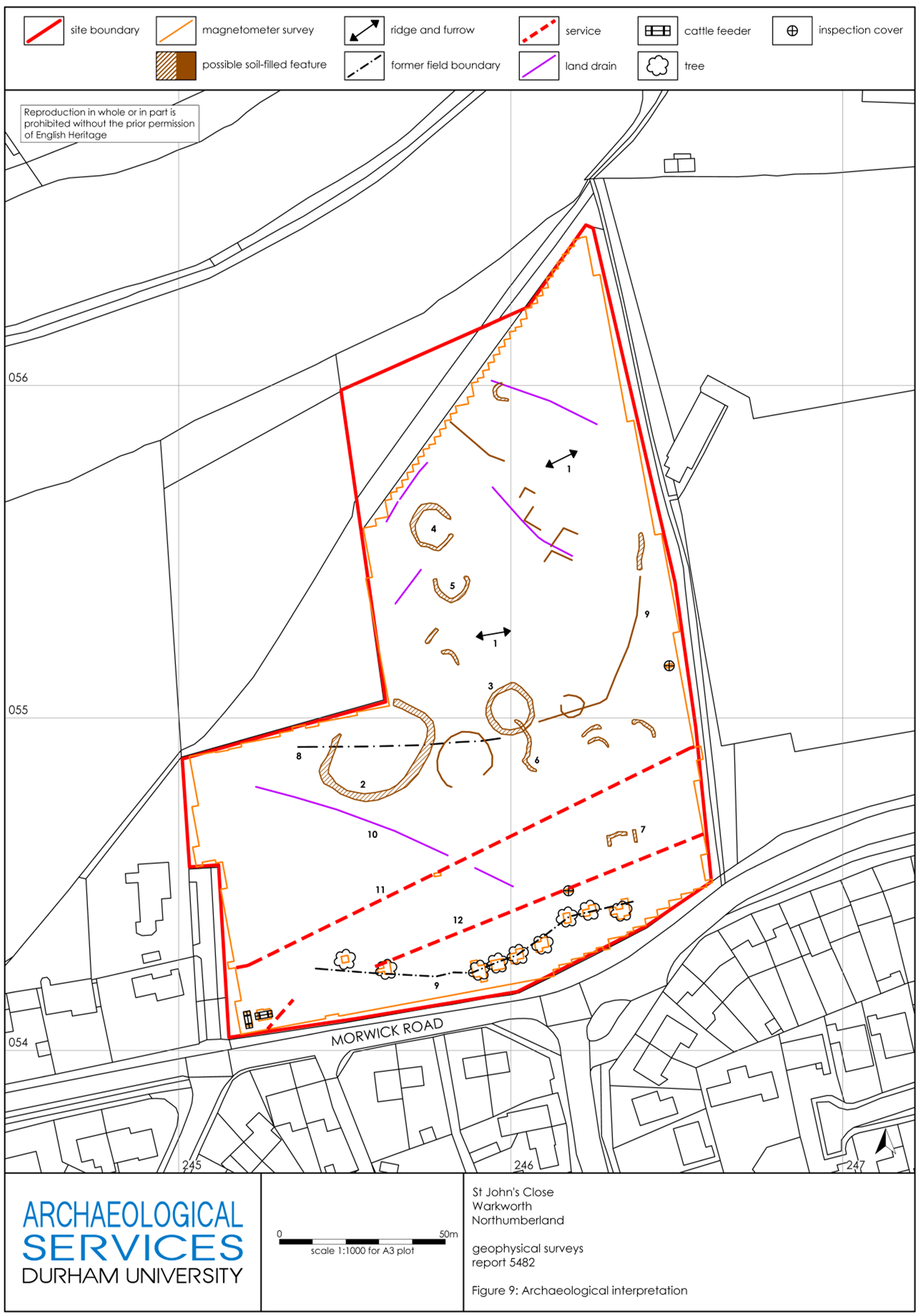
The results from two geophysical surveys in and around Warkworth Castle have now been digested and synthesized. The first survey sought to explore evidence for subsurface remains of the castle earthworks. The second survey examined a field called St John’s Close, sited within a corner of the medieval park attached to Warkworth Castle. Both surveys are intended to inform English Heritage’s on-going project to improve the way the history at the castle is explored and shared with visitors. Here, we share some of the highlights of these surveys: for the full discussion of the results, you can read the full report here.
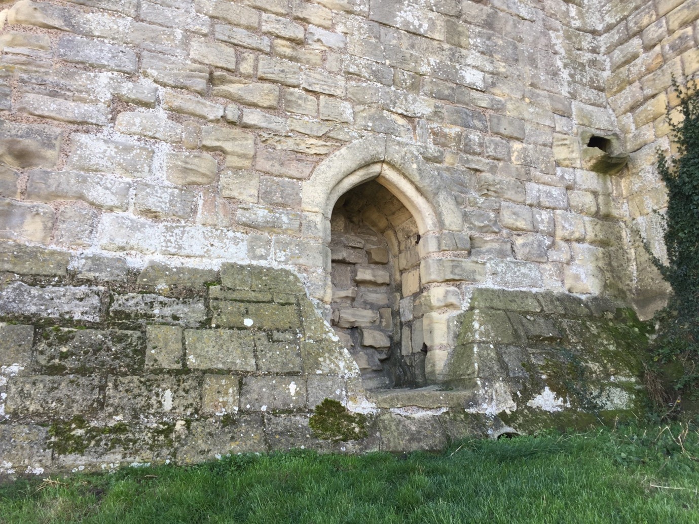
The first survey targeted three areas of the castle. The first was the top of the earthen mound, or motte (see a phased site plan here). Our aim here was to establish the presence or any subsurface features which may relate to any structures pre-dating the present late 14th-century Great Tower (Figure 1). Our results here were inconclusive: the subsurface examination certainly revealed a feature, perhaps a drain or path, associated with the postern of the present Great Tower (Figure 2). Other features may represent building or demolition rubble, but it’s not clear which.
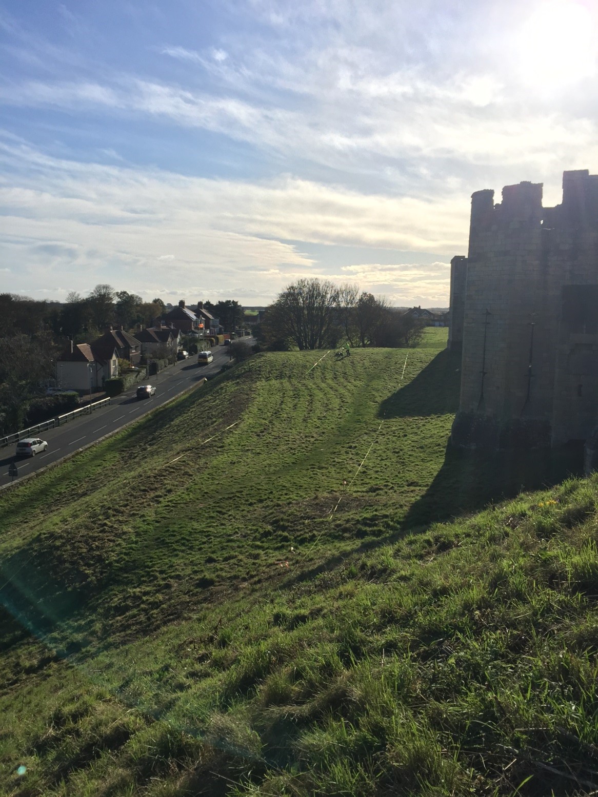
The second area of the castle earthworks to be examined was a portion of the castle’s raised bailey platform, east of the enclosing curtain wall presently dated to the late 12th-early 13th centuries. The earthworks of the bailey of Warkworth Castle pre-date any stone buildings known to survive at the present castle: this is because the earliest structures – among them the curtain wall – do not embrace the entirety of the earthworks (see a phased site plan here).
Our research question here was to establish why this eastern portion of the bailey was left unenclosed, upon the construction of the enclosing curtain wall. Here, again, our results were inconclusive with regards our research question, though the survey did throw some light on possible uses of this space in the later medieval-early modern period. The survey detected a trampled path from the area east of the eastern curtain postern, south of the 15th-century stable building, heading northwards, respecting the projecting mass of the 1290s Grey Mare’s Tail Tower (see feature 14, Figure 4 ). The relative phasing of this feature does not tell us a great deal, except that the path may post-date the construction of the Grey Mare’s Tail Tower. It may also suggest that the postern in the curtain wall, currently dated to the late 14th century, could be coeval with the Grey Mare’s Tail Tower, or it may have replaced an earlier iteration. This is the earliest possible arrangement, as the path could also be more recent in date.
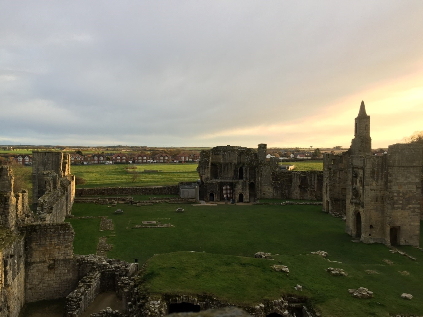
The final portion of the castle earthwork survey sought to establish the location and extent of features within the enclosed portion of the bailey (‘Area 1’, see Figure 4). Uncertainty remains as to the configuration of the bailey before a major phase of construction presently dated to the 15th century. This substantial campaign of building incorporated the construction of the compressed collegiate church (perhaps never completed) with exquisite covered passage, and a comprehensive rebuilding of the eastern portions of the Great Hall, Chamber block and chapel in the bailey, of which the finest surviving portions are the Lion’s Tower and the Little Stair Tower (Figure 5).
The most substantial, and perhaps important, finding of the geophysical survey of the earthworks relates to feature 2 (see Figure 4). Located in the south-eastern quarter of the bailey, it comprises a substantial segment of buried wall or robbed wall foundations, approximately 22m long (on an east-west axis) and c.2m thick. Though the feature stops short of the bailey curtain wall here, it clearly blocks the east curtain postern already mentioned, and therefore may very well pre-date it. The massive character of this feature suggests it may have belonged to a substantial, multi-storey building. Feature 2 also appears to meet the curtain wall at a right angle, with one possible implication being that it may have formed one wall of a square- or rectangular-plan building, which was demolished to make way for the present curtain wall. Curiously, although the castle is not very extensive, the concentration of known high-status buildings from the later 12th-century onwards is on the bailey’s western side. If feature 2 relates to a high-status building, it is unusual for being located in the eastern part of the bailey. Several other features were located within the bailey; these are discussed in the full report.
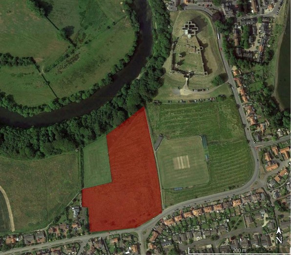
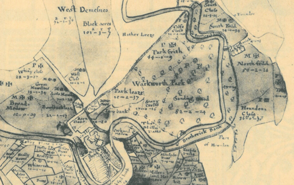
The second area examined by geophysical survey comprised part of the park of Warkworth Castle. The earliest record of the park is dated to the 13th century, but a park at Warkworth may have existed earlier still. Hogdson’s History of Northumberland, which assembled extensive records from the Alnwick Castle archives and elsewhere, offers a rich picture of the late medieval administration of the park, with records of repairs, infringements, agistments (a one off payment by a livestock owner to graze on the land of the landowner) and the collection and sale of underwood all recorded in 15th-century documents. The earthworks of the castle park have yet to be comprehensively mapped, but a portion of the south-east corner of the park, fossilizing the boundary of an historic field within the park called St John’s Close, does survive (see the previous Warkworth blog post for photos of these). This field was chosen as the target of geophysical survey to determine the survival of any features or buildings associated with the medieval park. Research on castle parks has demonstrated that they could feature a broad variety of structures, and were not simply enclosed areas. A further research goal was to ascertain the precise location of a documented park gate attested in a 17th-century estate map (Figure 7), which could represent the closest point of access into the park enclosure from Warkworth Castle.
Figure 7. Estate map of the 1620s, depicting Warkworth Castle (lower left), village and park boundary. The postulated park gate is the round-headed opening roughly half-way along the park’s eastern boundary, between the castle and St John’s Close. Top is south. From Hodgson’s A History of Northumberland, V, opposite p.136 (archive.org. link here).
Unfortunately, the survey results did not yield answers to the questions we posed regarding any medieval features within the area of parkland surveyed, nor was it possible to decisively establish the location of a park gate. The most significant find was in the form of several round features, either enclosures and/or hut circles, which are very likely prehistoric in date (Figure 8). A walk-over of this area confirmed that they were not visible at ground surface level, being concealed by ridge-and-furrow deemed to be medieval in date. The largest of these, feature 2, is also bisected by a former field boundary depicted on the early 17th-century estate map mentioned earlier, though not shown on either of the 1st edition OS maps. A possible caveat to the lack of medieval finds is feature 9 (see Figure 8); this could be a path or hollow-way, and it appears to cut (and therefore post-dates) the ridge-and-furrow. As the eastern terminus of feature 9 is close to the edge of the park boundary, it may point to the location of the suspected park gate. Its western extent appears to respect the trajectory of the lost field boundary, and there it may represent an early modern, post-medieval feature. For a fuller account of the features revealed by the survey, see the full report.
Although neither survey succeeded in yielding clear evidence to help answer all the research questions we asked at the beginning, they certainly improved our understanding of both areas examined. In the case of the castle earthworks, it is clear that a substantial building once occupied the south-eastern portion of the bailey, and it is now possible to map this accurately in relation to surface-level features. In the case of the park, we can tentatively identify the approximate location of a gate into the park, though we cannot be certain it is medieval in origin. More work may allow us to ascribe dates, or relative phases, to these features.
For English Heritage’s interpretation project at Warkworth Castle, these surveys have been invaluable, and we are grateful for the support of the Castle Studies Trust in pursuing them – especially during the difficulties in completing the surveys resulting from the Covid-19 pandemic. Going forward, the standing buildings of the castle have also been subjected to a separate, detailed analysis, and it is hoped that the bringing together of these two sets of data will offer a fresh understanding the site. Although the research is ongoing, a preliminary integration of both appears offers some new and tantalising ideas about the history of Warkworth Castle. These will inform our presentation of Warkworth Castle to the public, and improve our collective understanding of one of England’s finest castles.
With the 2020 excavation report now published, Shrewsbury Castle Excavation Director Dr Nigel Baker looks back at the two years of excavations and what they reveal about this important castle of the Welsh Marches.
Before the excavations in 2019 and 2020 funded by the Castle Studies Trust, Shrewsbury Castle was one of the least well understood major castles of the Welsh Marches. Its visible form is that of a classic motte-and-bailey, with earthen ramparts surmounted by stone curtain walls. However, the archaeological project and associated research has shown that the historical reality is more complex than this.
First recorded as a consequence of being besieged by local rebels in 1069, many aspects of its recorded history follow a familiar Marches pattern: heavy royal expenditure in the 12th and 13th centuries as a campaign base and in the face of Welsh raiding, followed by decline into obsolescence and ruination in the 14th, 15th and 16th centuries, arrested temporarily by a return to active service in the English Civil War in the 1640s. Its later history was as a private residence, distinguished by its ‘restoration’ by Thomas Telford in 1786-1790, and finally its return to public life as a council meeting hall in 1925 and as the home of a regimental museum in the 1980s.
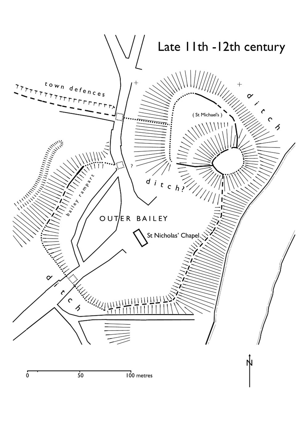
First of all, the Norman castle was not built on an empty site. It occupied the end of a ridge that was critical to the defence of the old Saxon borough, and the 2019 excavation demonstrated occupation here in the 10th or early 11th century, on a plateau or low knoll at about 68m AOD, higher than its surroundings, and at one end of the likely cross-peninsula borough defences. At present the archaeological evidence is limited to a single pit and its artefacts, but reading between the lines of the historical record, it is possible that the site was shared by a church dedicated to St Michael and perhaps a hall, maybe that of the pre-Conquest sheriffs.
Plan of Shewsbury Castle as it may have appeared in late 11th / early 12th century copyright Dr Nigel Baker. The black lines indicates probable masonry curtain wall lines, based on the presence of the ‘green slabby rubble’ masonry that appears at various junctures at the bottom of some elevations and seems to be early, meaning potentially pre-13th
The Norman castle of the 1060s wiped out all that had been there before, except the church, which appears in Domesday Book; this also records the loss of 51 tax-paying households when the castle was built. It consisted of a large motte overlooking the river, elevated to a height (80m AOD) equal to that of the royal and episcopal halls within the old borough, with a substantial ditch, discovered in 2019, around its base. West of the motte was a small inner bailey. Extending south was a much larger outer bailey, separated from the English borough further south by a second cross-peninsula ditch and supplemented in the 12th century by earth ramparts around the bailey perimeter. The small size of the inner bailey, in reality perhaps more of a barbican, suggests that the royal hall, documented from 1246 but probably present from the beginning, was on the motte top.
It is not yet clear when the earth and timber defences began to be replaced in stone, but stretches of thin, slabby rubble in the curtain walls and motte wing walls may be indicative of work in the late 12th or early 13th century.
Major changes took place throughout the 13th century, some documented, some suggested by the excavations. The single surviving medieval building, often called the hall, is fairly certainly the camera regis or royal chamber built in 1239-41, a date consistent with the dendrochronological evidence from the building. It may have been constructed as part of a larger rebuilding campaign that saw the west side of the inner bailey expanded westwards by pushing a terrace out over the gradient behind a newly-built ashlar curtain wall. This is one of the conclusions of the 2020 excavation trench through the western rampart, which found medieval tipped strata at a level below that of the natural gravel seen in the interior of the bailey in 2019.
Plan of Shrewsbury Castle in late C13. Copyright Dr Nigel Baker
Meanwhile, the east side of the motte was subject to erosion by the River Severn and the consequent partial collapse of the motte was recorded by an enquiry held in 1255; in 1269-71 a ‘great wooden tower’ fell down and was said to be totally destroyed. The motte top was repaired towards the end of the 13th century with a new wall built across the damaged side in red and white striped masonry. The motte ditch appears to have been infilled, mainly by the deposition of rubbish, and a new castle well, which survives, was dug within it.
As the town grew, the outer bailey was built over. In 1220-c.1250 when the town walls were built, the outer bailey was walled continuously with the rest of the town and no longer separated from it; the tenements that had been established there continued to pay their ground rents to the crown while those outside, further south, paid theirs to the borough.
Two early plans show what had become of the castle by the end of the 16th century. The Burghley Map of Shrewsbury of c.1575 shows the main building unroofed, a smaller building (perhaps St Michael’s) in ruins, and just one roofed building standing in the inner bailey in the area of the surviving well. A sketch plan by the master mason John Smythson of 1627 likewise shows the main building, and most of the curtain walls, in a ruined condition; it also shows a gatehouse of which there is no other evidence.
Restoration came in 1643-44 when the castle was garrisoned by the Royalists, and the borough’s mayoral accounts record expenditure on the main gate and its new barbican, a new postern gate, walls and outworks. The castle was captured for Parliament in February 1645; what appears to be battle-damage can be seen on the woodwork of the main gate and around the openings of the main building but this identification now needs confirmation by battlefield archaeologists. After its capture, the Parliamentarians continued the Royalists’ restoration of the main building, its roof and gallery built with timber felled in the winter of 1647. The castle was finally de-munitioned in 1686 and became a private residence.
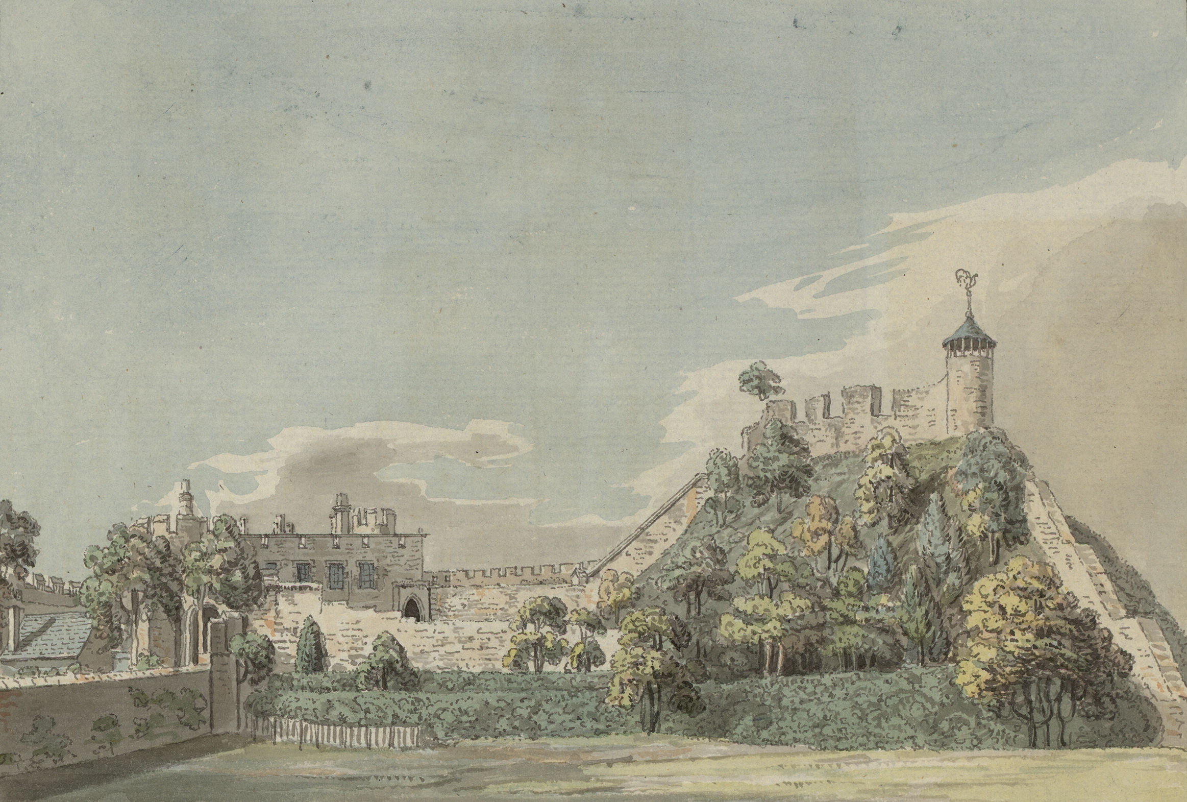
Shrewsbury Castle in 18th Century, note on the wall on top of the motte the possible base of windows of a high status building / Great Hall.
Thomas Telford’s ‘restoration’ of the castle in 1786-1790 for Sir William Pulteney was nothing if not brutal. The excavations in the inner bailey have shown that the interior was levelled down, scraped bare, and at least some of the material used to enhance or even create the ‘ramparts’ around the perimeter. Illustrations show that, until 1786, the motte top was still occupied by a 13th-century round tower and the ruins of other, as yet unidentified, buildings. These were all swept away and replaced by Telford’s ‘Laura’s Tower’, a fine, two-storey summerhouse in the Gothick style.
Dr Sarah Jane Gibbon and Dan Lee (UHI Archaeology Institute / ORCA) project leads for the Castle Studies Trust funded project explain the reasons behind the excavations they are undertaking at The Wirk in the Orkneys and what they hope to achieve during their two week dig.
Located on the south-western coast of Rousay, The Wirk is located in one of the most archaeologically rich parts of Orkney. The Orkney Research Centre for Archaeology (ORCA) is undertaking geophysical survey, archaeological excavations and 3D modelling at this enigmatic castle site (pending approval from HES).
The Wirk, meaning stronghold in Old Norse, and with the alternative name Westness Castle, is a small stone tower located close to the coast. It has variously been interpreted as a 12th century Norse Castle, a detached fortified bell-tower, a 13th century defensive tower for an incomplete church, a hall-house garderobe tower and most recently a 16th century tower and attached range.
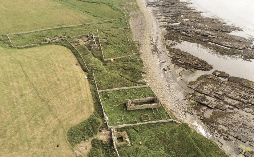
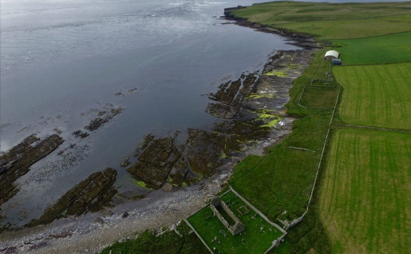
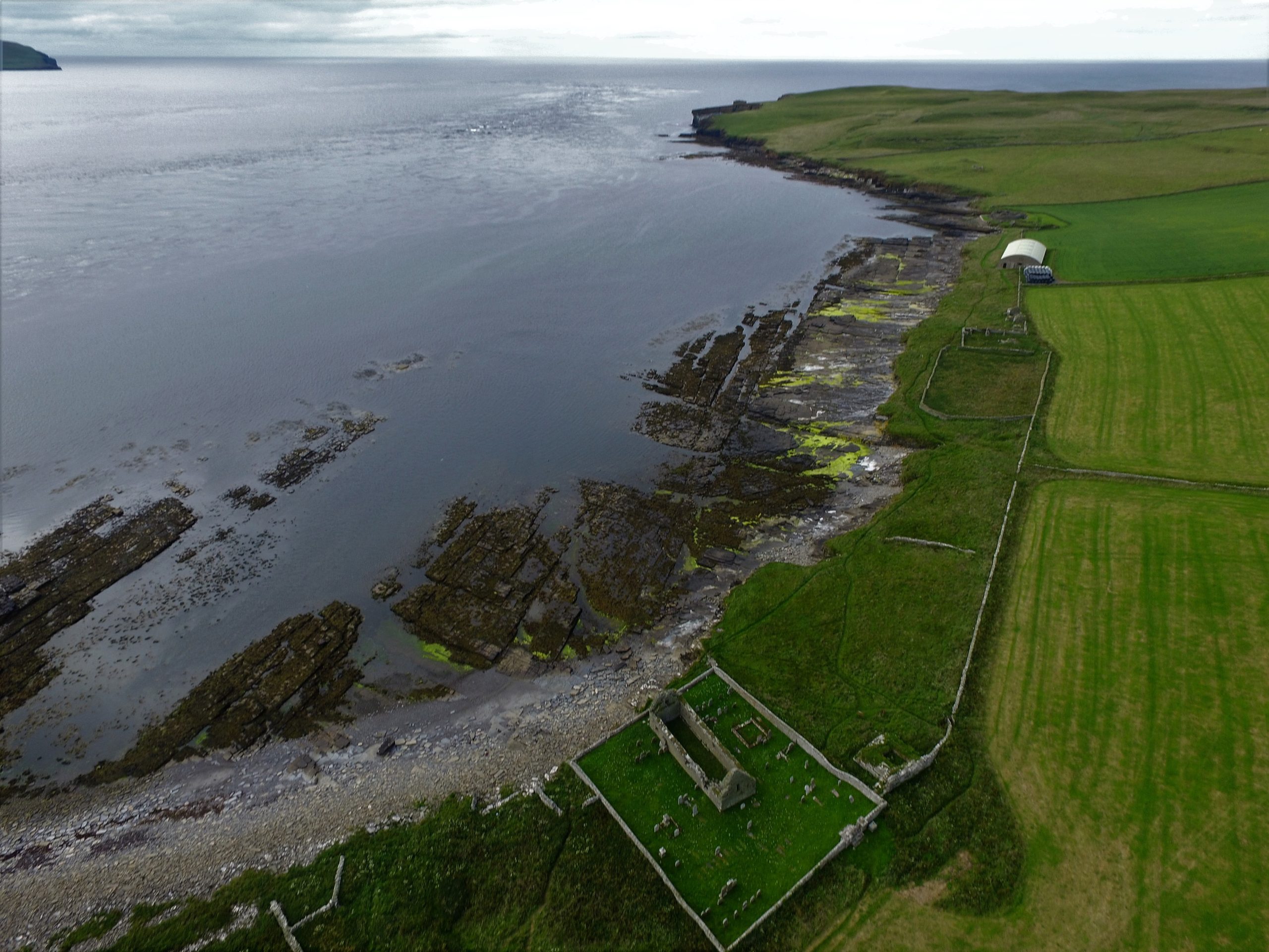
View of The Wirk, located on the righthand corner of St Mary’s Church yard in the foreground, looking northwest to Midhowe and the Atlantic Ocean (Image: Bobby Friel @TakeTheHighView).DCIM100MEDIADJI_0558.JPG
Minor clearance and excavation in the 1920s identified similarities in construction between The Wirk and the 12th century Cubbie Roo’s Castle, on the nearby island of Wyre, considered to be one of the earliest stone keeps in Scotland. The Wirk is located in Westness which has been a large estate since at least the 12th century when it was the home of the Norse chieftain Sigurd of Westness (Orkneyinga saga). It is adjacent to Rousay parish church, likely to date from the 12th century, with standing remains of 16th century date on earlier footings.
Recently, the 12th/13th century date attribution of The Wirk has been rejected in favour of a 16th century date. This new interpretation is based on the built remains and 16th century architectural fragments which were found in the 1920s. However, architectural fragments of 12th/13th century date were also present and nearby archaeology, particularly the discovery earlier this year of a Norse hall at Skaill by the UHI Archaeology Institute would suggest this was a high-status place in the saga period. This is not to dispute that The Wirk may also have been in use in the 16th century when the estate was owned by a prominent Orkney family. One of the objectives of this project is to excavate trial trenches over Clouston’s excavation and at the eastern end of the site to identify the earliest phases of the tower and adjacent building. Upper parts of the tower were substantially rebuilt in the 19th century and so excavation will allow us to record parts of the site that have not been knowingly rebuilt.
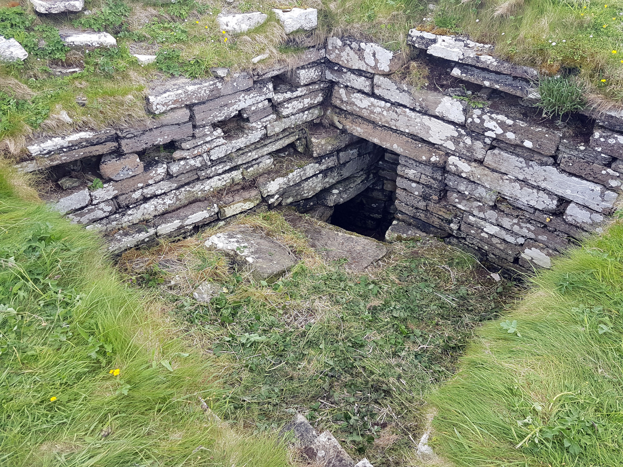
Inside The Wirk tower, looking southeast, showing the entrance to an underground well or passage (Image: Dan Lee)
Along with the excavations, targeted geophysical survey around The Wirk undertaken in September 2020 aims to better understand any relationships between the tower and the buildings/features which surround it. The results show that the walls planned by Clouston are accurate and that they likely survive just below the ground surface. 3D modelling of The Wirk and Cubbie Roo’s Castle will enhance our understanding of these comparable sites and allow the public to explore the remains online.
The start of the project was delayed in 2020 due to the Covid-19 pandemic, and we will be glad to finally get on site for the excavations in July.
Dr Jonathan Clark, Historic Buildings Director, FAS Heritage and project lead for the Castle Studies Trust funded 3-D Reconstruction of C12 Lincoln Castle explains how it was done and the challenges faced in doing it.
A virtual 3-D reconstruction of Lincoln Castle as it may have looked in the late 12th-century has been completed by Peter Lorimer, Pighill Illustration in collaboration with FAS Heritage. The reconstruction was funded by the Castle Studies Trust and made possible through 15 years of archaeological research for the Lincoln Castle Revealed project. The project consisted of a £22m repair and restoration programme to conserve the site and renew the visitor experience funded by the National Lottery Heritage Fund, Lincolnshire County Council and the European Regional Development Fund. The programme provided opportunities for research-led archaeology which yielded a wealth of new information about the site.
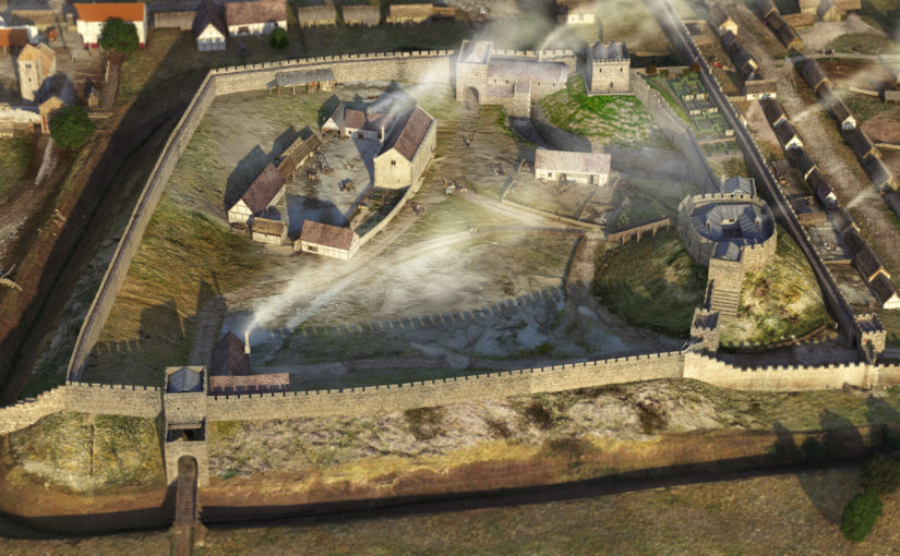
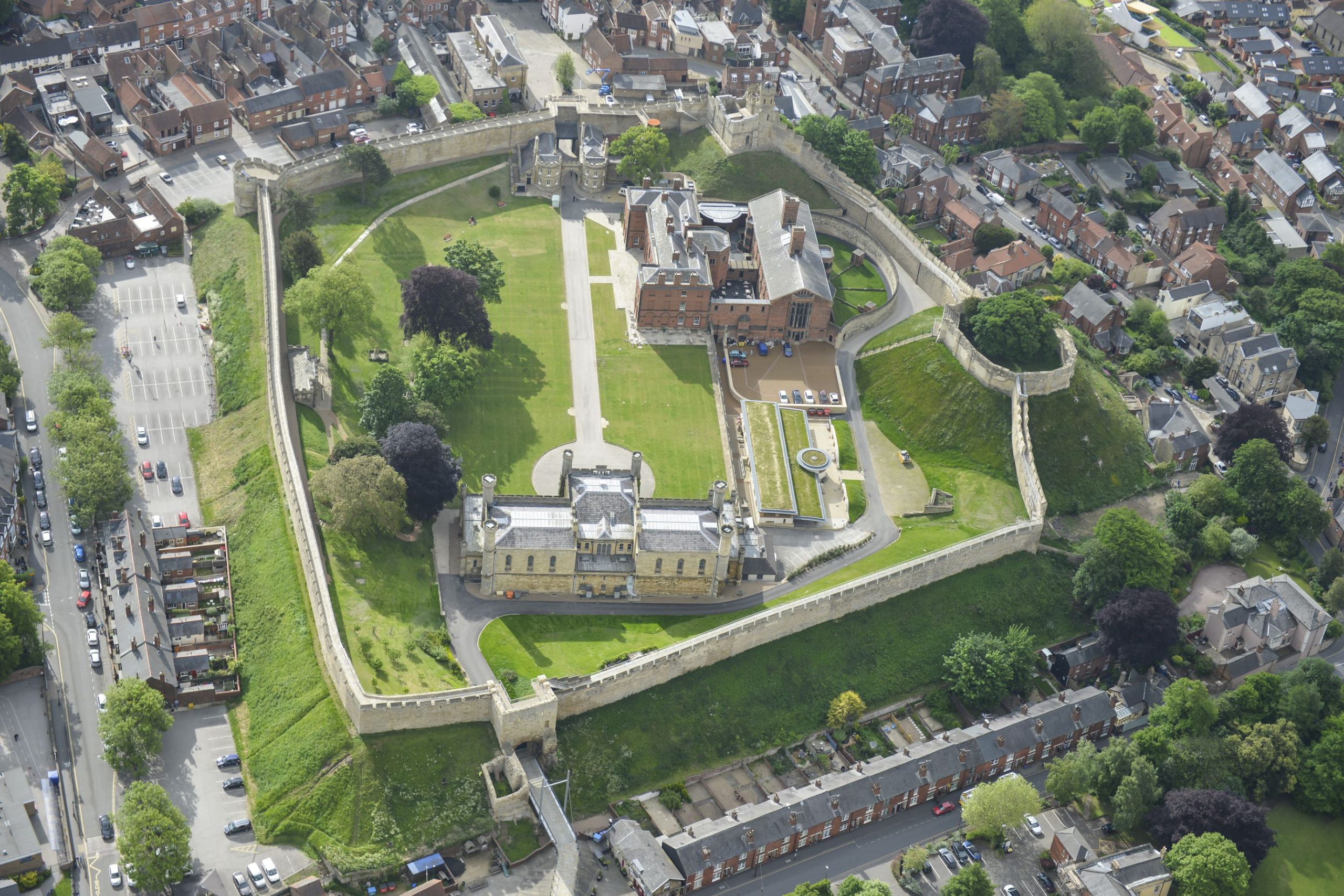
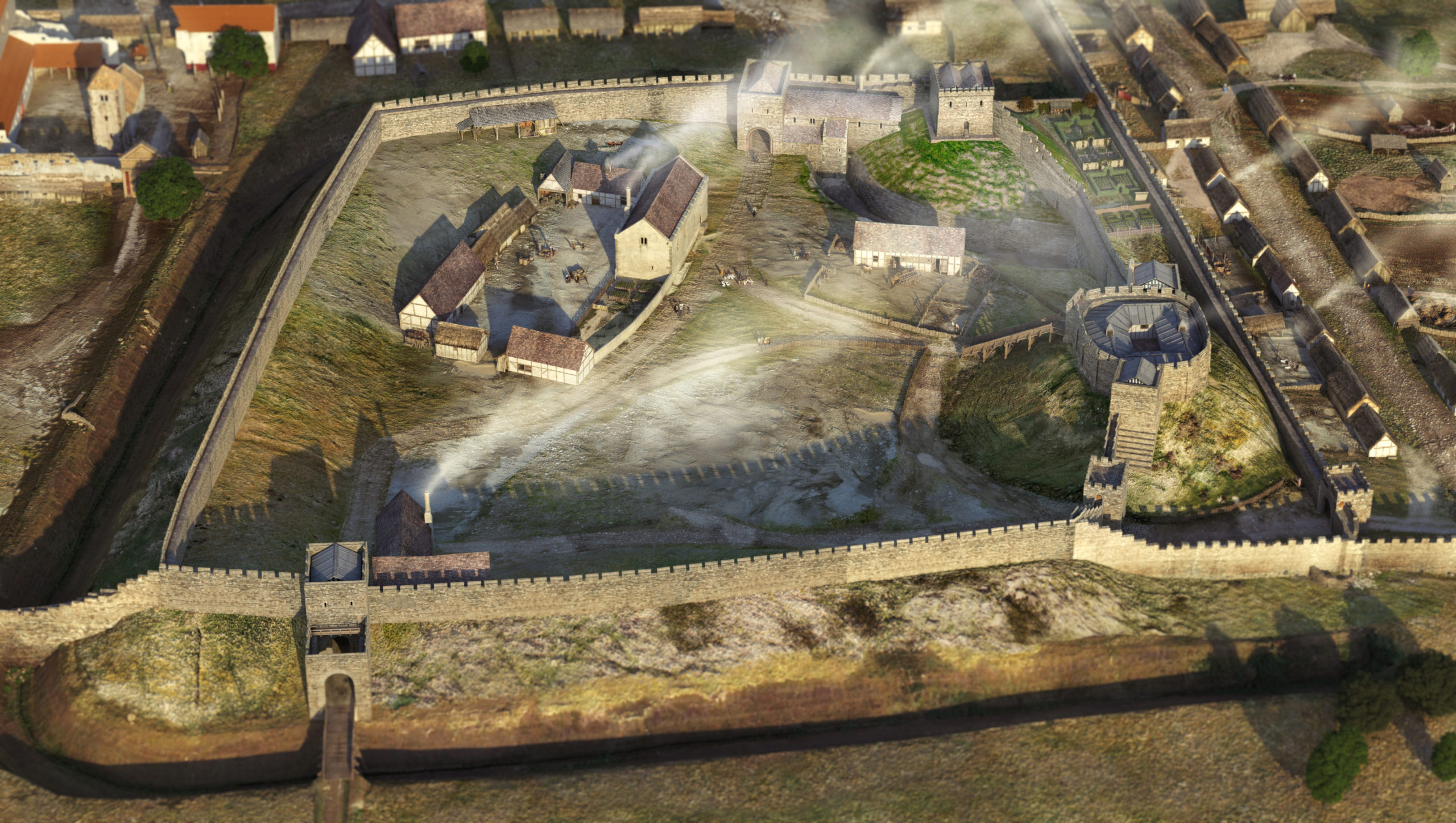
Mondern day Lincoln Castle from the west copyright Andy Tyner Photography on behalf of FAS Heritage and Lincolnshire County CouncilLincoln Castle as it could have been in the late C12 copyright FAS Heritage and Pighill Illustrations
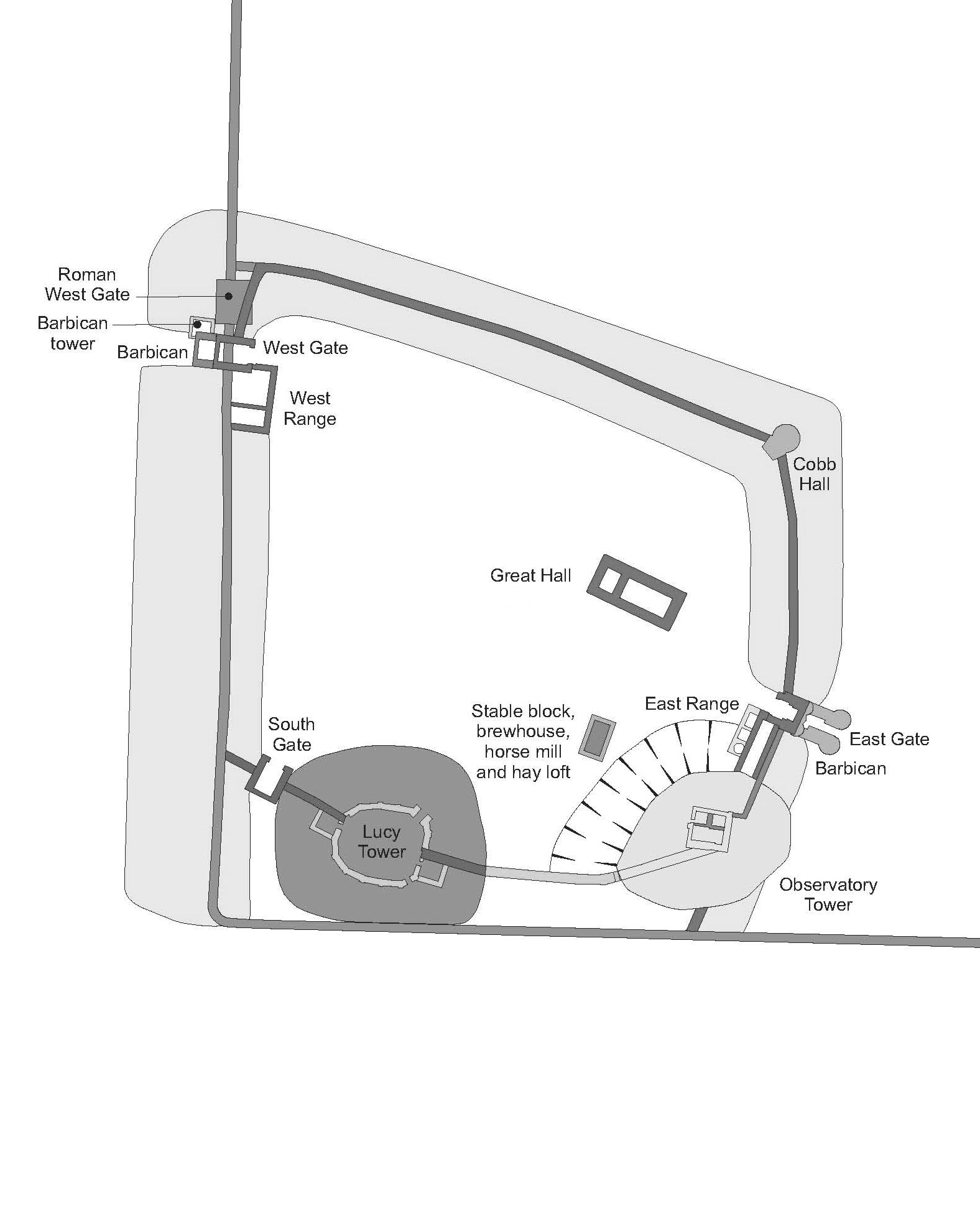
William the Conqueror established Lincoln Castle in 1068 in the walled enclosure of the former Roman colonia. The Lucy Tower motte was built in its southwest corner reusing the west and south walls to defend the new inner bailey. The next 100 years saw rapid development: originally earth and timber, the Conquest-period castle was replaced in masonry, a process now understood to have started by the 1080s including East and West Gates; by the early 12th century the stone enclosure of the bailey and internal gate ranges were complete, along with the Lucy Tower shell-keep and later Observatory Tower. Inner bailey buildings were also contacted during excavation including the Great Hall, stables, East Range and the Observatory Tower motte and ditch, all contributing information to the reconstruction. Evidence for a lost South Gate to match East and West Gates was found; along with a reappraisal of the early form of the Lucy Tower shell-keep it provided information about a former southern enclosure. This enclosure was abandoned, probably by the early 13th century, when the castle contracted to the form of the current enclosure.
It was the culmination of this intense century of development, arrived at by the late 12th century that was selected for the digital reconstruction.
Plan of Lincoln Castle in C12 copyright FAS Heritage
Archaeological excavation and detailed building recording formed most information about the early form of the castle, but the assembly of the 3-D reconstruction led to reappraisal of other parts of the castle; previously unnoticed anomalies were discovered which required further analysis.
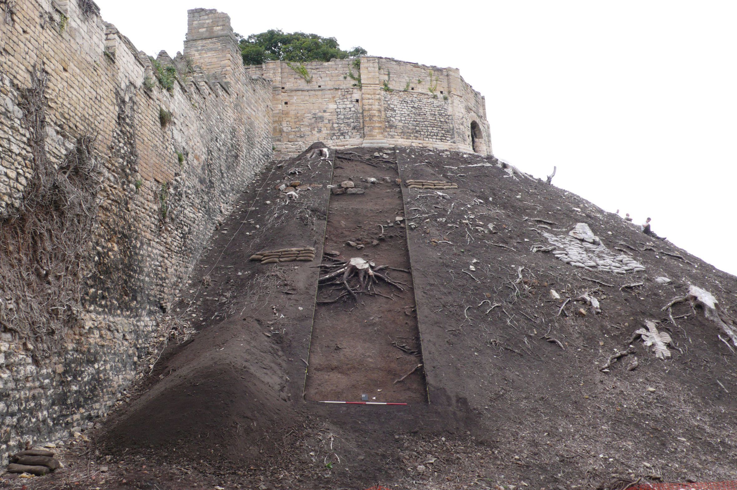
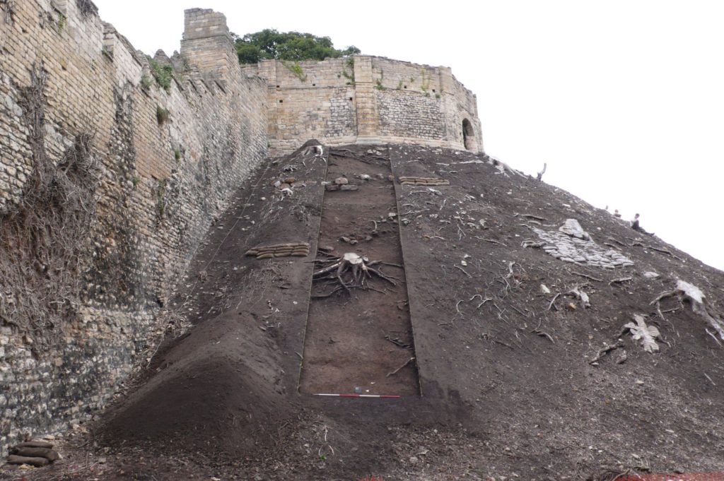
The lost southern enclosure and South Gate were both identified from fragmentary evidence and establishing the exact position and size of the original south wall presented a challenge. When reconstruction began there was little information on this wall except a projection of the line of the southern colonia wall. This placed the south wall slicing through the Lucy Tower motte – a relationship which did not seem likely. However, recent work on this part of the motte during a programme of banks stabilisation provided more information. A substantial medieval masonry wall measuring 3m wide and traversing the Lucy Tower motte west-east was revealed. The wall is probably founded on the Roman wall indicates the motte may have been constructed against it, flattening its southern side.
The Lucy Tower Motte after the removal of dense vegetation. The fragmentary masonry remains of a structure can be seen towards the top of the trench. Copyright FAS Heritage
The reconstruction provides a sense of where concentrations of occupation were; around East Gate and Observatory Tower, the Lucy Tower, the Great Hall and around West Gate. With the discovery of South Gate it is easier to appreciate how these areas were autonomous. Other areas within the castle, particularly the western side, are presented as large open spaces; without further investigation these zones cannot be reconstructed easily.
The Lucy Tower, sat upon on an enlarged motte, can now be shown with its original east and west chamber blocks, internal ranges and window overlooking the city. With the tower, wing walls and South Gate, these formed a discrete enclosure.
Detail on the form of the Observatory Tower in the late 12th century can also be added. The tower is shown as a gaol tower which replaced a predecessor developed by Earl Ranulf during the Anarchy, later commandeered to become the county gaol. A stone ‘skirt’ around the base of the motte and a motte ditch were found and formed a hard circuit detaching the gaol from the rest of the castle.
The reconstruction will be made available across a range of media. The analytical process and collaboration with Pighill Illustration provided an opportunity to translate the archaeological study of the castle into a tangible representation. It enables the results of the research programme to be conveyed to a wide audience and goes hand-in-hand with the publication of a book about the Lincoln Castle Revealed Project in July 2021.
Shrewsbury Castle Excavation Director, Dr Nigel Baker, reviews the second season of excavations at the castle which has just ended, with an unexpected conclusion.
Shrewsbury Castle has sometimes been described (most often by the writer of this blog!) as one of the best-preserved shire town motte-and-bailey castles in the west of England. This remains true – at least in the sense that it has never been quarried away for gravel, nor had a prison or law courts built on top of it, nor was it demolished and redeveloped after the Civil War. Nevertheless, such a statement now requires a hefty footnote.
A visitor, walking into the inner bailey at the foot of the motte sees crenelated curtain walls rising from the top of substantial ramparts: the impression of a classic castle sequence with earth-and-timber fortifications renewed in stone, is overwhelming. The 2020 work has however shown that neither the ramparts nor the western curtain walls are quite what they seem. Excavation to a depth of more than two metres in the western rampart has shown that at least half of its height was a product of the post-medieval centuries – with a substantial contribution probably made by Thomas Telford during his ‘restoration’ of the castle in 1786-90, enhanced by his simultaneous lowering of the ground level across the interior.
Shrewsbury Castle excavation trench in western rampartas viewed fromfrom C13 logis block. Courtesy of Nigel Baker
But the medieval strata below Telford’s rubble also show that the western curtain wall, and by implication the standing castle building, the camera regis of the later 1230s, can no longer be seen as simple improvements to the original earthwork castle as the ground beneath them was found to drop away sharply, the slope levelled up by a massive medieval earthmoving operation. It seems that the present outline of the castle – and the familiar view of it from the railway station below, are a product of the early 13th century (dating subject to confirmation when the pottery has been analysed) – dubbed Shrewsbury Castle 2 by the excavators. The ‘original’ motte-and-bailey, first heard of when it resisted a siege in 1069, must have had a perimeter that was around 25% smaller, confined to the original hilltop. This castle (inevitably ‘Shrewsbury Castle 1’) was nevertheless heavily fortified, as the substantial motte ditch found in 2019 shows. As originally conceived, the ‘inner bailey’ was little more than a lobe-shaped barbican, protecting access up onto the motte, with little room for buildings within it. One of the implications of this is that the most important buildings – like the royal hall – must have been on the motte top.
The medieval landfill operation is also of interest on account of the rubbish contained in its strata. Preliminary visual identification of the animal bones suggests that game species are present, possibly pike, possibly swan, and it is likely that further work on this material will add to the growing corpus of evidence for high-status diet on castle sites throughout the region.
The excavation was funded by the Castle Studies Trust and supported by University Centre Shrewsbury under Professor Tim Jenkins and Dr Morn Capper. Archaeological direction was by Dr Nigel Baker and Dai Williams and the work was undertaken by local volunteers and UCS postgraduates and undergraduates.
With HES giving the provisional sign off for the excavation at The Wirk to take place in the week commencing 21 September, and the geophys survey to take place the previous week, project leads Drs Dan Lee and Sarah Jane Gibbon outline the background to the project and what they hope to find.
Located on the south-western coast of Rousay, The Wirk is located in one of the most archaeologically rich parts of Orkney. The Orkney Research Centre for Archaeology (ORCA) is undertaking geophysical survey, archaeological excavations and 3D modelling at this enigmatic castle site (pending approval from HES).
The Wirk, meaning stronghold in Old Norse, and with the alternative name Westness Castle, is a small stone tower located close to the coast. It has variously been interpreted as a 12th century Norse Castle, a detached fortified bell-tower, a 13th century defensive tower for an incomplete church, a hall-house garderobe tower and most recently a 16th century tower and attached range.
The Wirk located on the side of St Mary’s Church graveyard, looking south. credit: Bobby Friel @TakeTheHighView
Minor clearance and excavation in the 1920s identified similarities in construction between The Wirk and the 12th century Cubbie Roo’s Castle, on the nearby island of Wyre, considered to be one of the earliest stone keeps in Scotland. The Wirk is located in Westness which has been a large estate since at least the 12th century when it was the home of the Norse chieftain Sigurd of Westness (Orkneyinga saga). It is adjacent to Rousay parish church, likely to date from the 12th century, with standing remains of 16th century date on earlier footings.
Recently, the 12th/13th century date attribution of The Wirk has been rejected in favour of a 16th century date. This new interpretation is based on the built remains and 16th century architectural fragments which were found in the 1920s. However, architectural fragments of 12th/13th century date were also present and nearby archaeology, particularly the discovery earlier this year of a Norse hall at Skaill by the UHI Archaeology Institute would suggest this was a high-status place in the saga period. This is not to dispute that The Wirk may also have been in use in the 16th century when the estate was owned by a prominent Orkney family. One of the objectives of this project is to excavate trial trenches over Clouston’s excavation and at the eastern end of the site to identify the earliest phases of the tower and adjacent building. Upper parts of the tower were substantially rebuilt in the 19th century and so excavation will allow us to record parts of the site that have not been knowingly rebuilt.
Inside The Wirk tower, looking southeast, showing the entrance to an underground well or passage (Image: Dan Lee)
Along with the excavations, targeted geophysical survey around The Wirk aims to better understand any relationships between the tower and the buildings/features which surround it. 3D modelling of The Wirk and Cubbie Roo’s Castle will enhance our understanding of these comparable sites and allow the public to explore the remains online.
Clouston, JS 1931 Early Norse Castles. The Orcadian. Kirkwall
Gibbon SJ 2017 A Survey of Norse Castles in Orkney, in P Martin (ed) Castles and Galleys: A reassessment of the historic galley-castles of the Norse-Gaelic seaways. Islands Book Trust. Laxay. 226-248.
Featured image: View of The Wirk, located on the righthand corner of St Mary’s Church yard in the foreground, looking northwest to Midhowe and the Atlantic Ocean (Image: Bobby Friel @TakeTheHighView).
In its latest round of grants the Castle Studies Trust funded an ambitious 3-D reconstruction of the 12th-century form of Lincoln Castle. Project lead, Jonathan Clark, explains the background to and aims of the project.
Lincoln Castle is one of England’s great castle complexes, developed during an initial intense period of use which straddles the Conquest through to the first half of the 13th century. The reconstruction builds on the work of the recent Lincoln Castle Revealed project, which involved the conservation and repair of the castle fabric and bailey buildings, the creation of a new exhibition space, and provided a wealth of opportunities for research-led archaeology. The results of the archaeological campaign – which encountered remains from every century from the 1st to the 20th – have greatly enriched the story of the site as a whole.
Archaeological investigations encountered elements of the Roman fortress and later Roman Upper City, the defensive enclosures of which appear to have shaped future land-use patterns well into the medieval period, including the form of the castle. The west and south Roman walls stood long into the medieval period; indeed, parts of the western defences still stand to the south of the west castle wall. The southwestern corner of the Roman fortress provided the western and southern extent of the castle bailey.
Surveying the Observatory Tower. While the current external appearance of this tower is entirely due to changes in the 1830s, the interior fabric still retains important evidence as to its earlier form.
The main development of the castle in stone appears to be from the 1080s into the mid 12th century, a period which will be captured by the reconstruction. This campaign of work included the construction of East and West Gates, the stone enclosure of the bailey, the 12th-century Lucy Tower shell keep, the development of internal ranges against east and west curtain walls, adjacent to the gates, and a hitherto unknown South Gate. The South Gate position has been identified in the fabric of the south curtain wall, while its appearance has been confirmed by an early draft plan of Lincoln by John Speed, dated to 1607.
The Lucy Tower Motte after the removal of dense vegetation. The fragmentary masonry remains of a structure can be seen towards the top of the trench.
The investigations also provided valuable new information about the form and development of the main shell keep (the Lucy Tower) and the southeastern tower (known from the early 19th century onwards as the Observatory Tower). The Observatory Tower, which briefly upstaged the Lucy Tower during the Anarchy years of the early 12th century, was originally detached from the rest of the castle bailey by a substantial ditch. This ditch featured a stone revetment on the tower side which was carried up to encase the lower part of the mound on which the tower sits. The tower was subsequently remodelled to serve as gaol tower. More is now known of the Lucy Tower including the form of the roof, openings and the arrangement of rectangular chamber blocks, or turrets, to the east and west of it.
A segment of the interior wall face of the Lucy Tower. The small sockets are putlog holes, while the large blocked sockets housed timbers that joined with a timber ring-beam.
The remains of the main castle hall and various service buildings were also investigated as part of the Lincoln Castle Revealed project. Their positions are now accurately plotted within the castle bailey and these buildings are being added to the 3-D reconstruction.
A book on the archaeological discoveries from the project is forthcoming but the 3-D reconstruction will allow all to visualise an explore Lincoln Castle at its zenith. The reconstruction is being prepared by Pighill Archaeological Illustration advised by the Lincoln Castle Revealed archaeological team.