Lowther Dig Diary Two: End of Week One at Lowther Castle and Village Excavation

At the end of the first week of four, project lead Sophie Ambler gives an update of what has been going on the excavation.

As we draw to the end of our first week of the Lowther Medieval Castle and Village project, the team has made excellent progress.

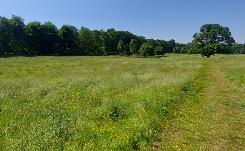
Before the archaeologists arrived, the ground staff at Lowther Castle prepared the site – a big task, with the mowing of large areas of the north park. In recent years, the Lowther team has been rewilding the estate, allowing the grass and wildflowers to grow as a haven for wildlife. This meant we needed to balance the demands of the project – ensuring ready access for geophysical surveying – with the requirement to preserve this rich habitat as far as possible.

Subscribe to our quarterly newsletter

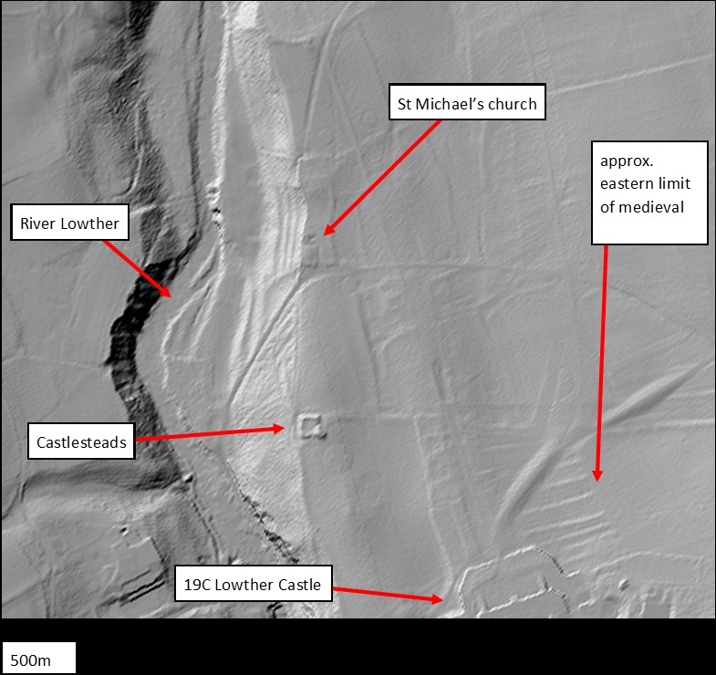
The LiDAR and earthworks survey (discussed in our first post) allowed us to identify the principal north-south run of the medieval village along the eastern half of the site, together with the road or routeway connecting it to the medieval castle. This was the area we really wanted to survey and which had to be mowed. Meanwhile, a long strip running down the western side of the site, where we expected little medieval habitation, was left unmown. Walking across the site to the church yesterday, I was greeted by a kaleidoscope of butterflies cavorting in this long grass, and was glad we’d made this compromise!

Day One: Rob Evershed from Allen Archaeology leading student archaeologists on the geophysical survey. This is at the southern of the site, atop the village earthworks.

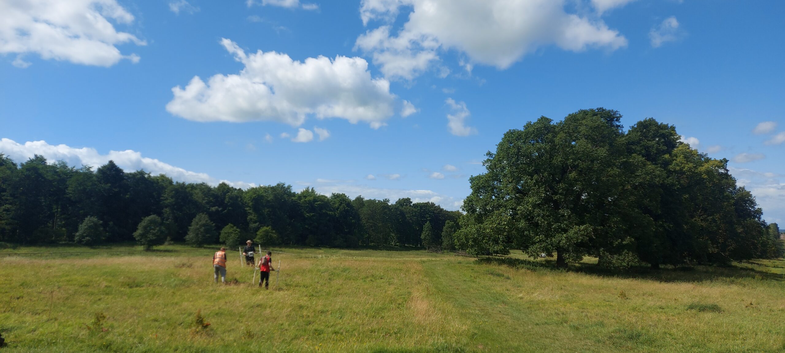
The geophysical survey is now largely complete. It has been led by Rob Evershed, a geophysical expert from Allen Archaeology, with the help of the project’s student archaeologists from UCLan. Rob first staked out thirty-metre grids, before training the students in the patient and disciplined task of geophysical surveying. As I learned this week, this means dressing ready for the task (no metal can be worn at all – including metal clasps and buttons – as it can interfere with the results) and carrying the equipment at a slow and steady pace across the grids.

Day Four: Rob and UCLan student, Dominic Scott, scrutinising the geophysics results.

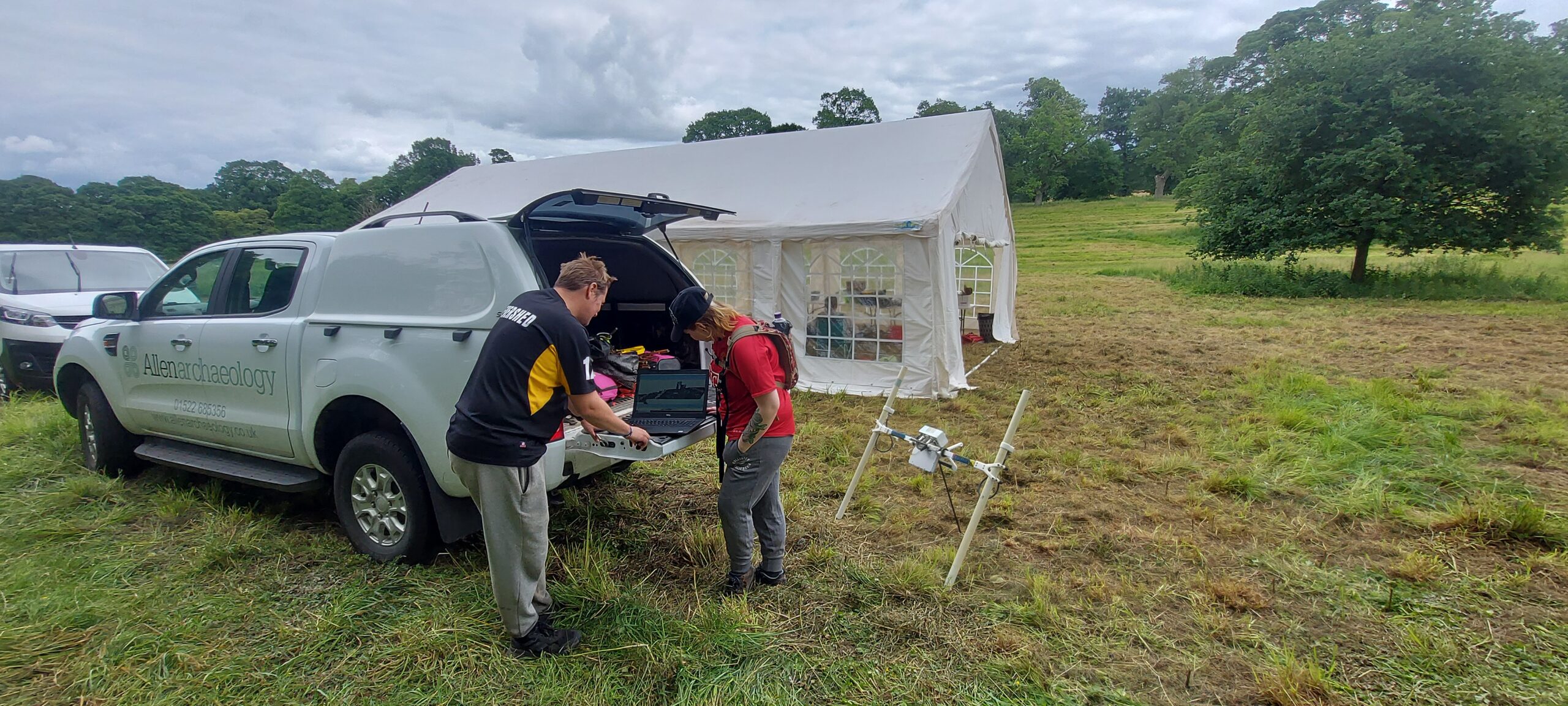
The results are still coming in, but have already been hugely helpful. Rob was able to plot services running close to the castle (and thus where we shouldn’t be digging) and spot a target for trench three: what looks like a square ditch, potentially associated with one of the dwellings built along the east-west routeway linking the castle to the main north-south run of the village. As I left on Thursday afternoon, the team was busy opening Trench Three, incorporating the routeway and this anomaly, in the hopes of identifying features and finding dating evidence.

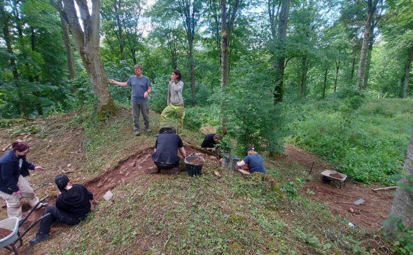
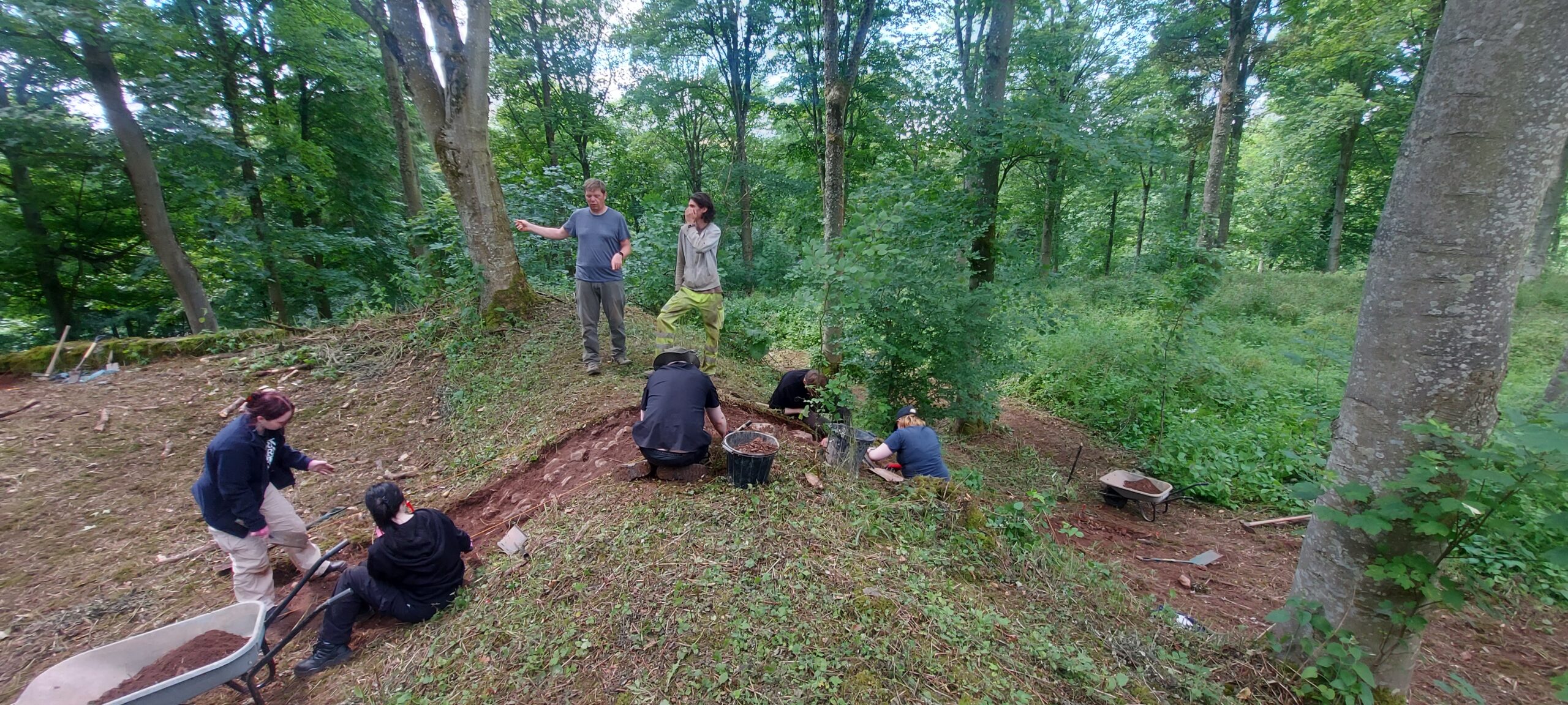
Meanwhile, on Monday the team had opened Trench One and Two at the castle earthwork. It wasn’t possible to use geophysics in this area, because the earthwork stands in woodland and the root systems would create too much disturbance for any results to be meaningful. The earthwork had been heavily overgrown but again, in advance of the project, the Lowther team cleared all the long grass and nettles across and around the earthwork.

Day One: the trench across the nothern bank of the castle earthwork, with Jonny Milton from Allen Archaeology (in the high vis trousers) and Jim Morris from UCLan directing the student archaeologists

This not only allowed the archaeologists easy access but also revealed the earthwork in all its glory. I was struck afresh with its scale, particularly its height, and its shape and features are now far easier to discern. The earthwork is roughly square, with an entranceway on the eastern side (presumably accessed from the east-west routeway from the village). At the south-west corner a significant continuation of the bank protrudes to form a platform. The great bank of a ringwork castle would likely have been surmounted by a timber palisade, and we’re speculating that this platform may have been home to a wooden tower, sited to give wide-ranging views north, east and south. Meanwhile, the western length of the castle was protected by a steep slope running down to the River Lowther.

Subscribe to our quarterly newsletter

The two trenches were sited on the north and western sides of the earthwork. Under the guidance of Jonny Milton of Allen Archaeology and Jim Morris of UCLan, the student archaeologists removed the turf and set about digging. The northern trench runs from the castle interior, cutting through the bank and down along the bank’s steep northern slope. We hope this will allow us to see how the bank was constructed and provide dating evidence. There is still a long way to go, but already the trench has yielded a fragment of roughly made pottery, which will be analysed to see if it is early medieval. Over week two, the archaeologists will continue working their way down through the trench, stepping it out to take account of the steep slope.

Meanwhile, the western trench yielded some curious results: a couple of trays’ worth of Victorian detritus, a stone wall, and a floor surface nicely laid with hand-made bricks: evidence that part of the castle interior was taken over and used for purposes that are so far unclear. The team aims to investigate this phase further and, after thoroughly recording these features, to dig further down in the hope that they’ve preserved features from the medieval phase.

Subscribe to our quarterly newsletter

There’ll be more entries in our Dig Diary to follow, and meanwhile you can follow the project’s progress on Twitter via the hashtag #LowtherMedievalCastle.

Lowther Dig Diary One: Lowther Medieval Castle and Village project

On Monday 26 June the excavation and geophysical survey of Lowther’s medieval castle and Village gets underway, finishing on Friday 21 July. Here, project lead Sophie Therese Ambler from the University of Lancaster explains what she hopes the team of students and academics from the university and University of Central Lancaster with the support of Allen Archaeology hope to find over the next three weeks.

Overlooking the Bampton Valley on the edge of the Lake District, the picturesque ruins of Lowther’s nineteenth-century castle are one of the region’s most popular attractions. Less well known are the earthworks immediately to the north, the remains of a medieval castle and village. Preliminary work suggests the site may date to the late eleventh or early twelfth century. If so, it could provide rare evidence of the conquest of Cumbria by King William Rufus and his brother, King Henry I – a generation after the Normans seized control of the rest of England. The site is potentially of national significance but has never been fully investigated.

Subscribe to our quarterly newsletter

Who built the castle and its settlement, when and why? The Lowther Medieval Castle and Village project brings together historians and archaeologists from the North West to uncover the site’s biography.

The Castle Studies Trust has generously funded a survey and excavation, which will take place from 26 June to 21 July 2023. The project team brings together History at Lancaster University, Allen Archaeology, the University of Central Lancaster (UCLan) and Lowther Castle and Gardens Trust.

In the 1990s, the Lowther Estate commissioned a landscape report and earthwork survey. The report suggested that the Castlesteads earthwork dates to the early Norman era (late eleventh or early twelfth century), and categorised it as a ringwork, a characteristic rural castle form of the early post-Conquest period. It noted that the castle is ‘of considerable archaeological importance, particularly as it was potentially the original fortified site at Lowther’.

The report also suggested the village was integrally linked to the ringwork and ‘likely to have been a planned settlement, established under close manorial control’. The settlement, the report noted, ‘is of considerable importance being a fossilised medieval settlement and it has the potential to significantly inform our understanding of medieval nucleated settlement in Cumbria.’ At the north of the site stands St Michael’s church, which is medieval in origin and potentially related to the castle and settlement.

Lidar image showing the extent of Lowther Castle and Village

The extent and form of the site as a whole can now also be seen in LiDAR imaging (see image above), noting that the circular features are intrusions brought by landscaping after the demolition of the settlement in the seventeenth century. 

The working hypothesis is that the site dates to the Norman conquest of Cumbria. Unlike the rest of England, Co. Cumbria was not conquered by the Normans in 1066. The region was historically part of the Kingdom of Cumbria, which stretched from Strathclyde across the Solway. Then, while the Normans were conquering lowland England, the area from Lowther northwards was conquered by the Scottish king Máel Coluim III. Cumbria was only annexed by the Normans in 1092, when William the Conqueror’s son, William Rufus, led an expedition to the area. According to the Anglo-Saxon Chronicle, the king then ‘sent many peasant people with their wives and cattle to live there and cultivate the land’.

Subscribe to our quarterly newsletter

Could Lowther’s medieval castle and village date from this era? Beyond the estimations provided by the earthwork survey, it has been suggested from place name and field pattern evidence that many medieval villages in this area of Cumbria were planned or remodelled settlements established following the 1092 annexation of Cumbria and peopled largely by colonists. But written evidence for Cumbria in this era is extremely sparse, so it is up to archaeology to test this theory. Whatever the investigation finds, the archaeology at Lowther offers a fantastic opportunity to understand rural castle building and life in medieval Cumbria.

In the first few days of the project, the team will conduct a geophysical survey, before opening trenches across the Castlesteads and settlement earthworks. Visitors to Lowther Castle will be able to visit the dig site – if you are in the area, please do come and say hello.

The team will be posting regular updates on the project in a Dig Diary here on the Castle Studies Trust website. You can also follow the project on Twitter, via the hastag #LowtherMedievalCastle

Meanwhile, further information is available on the project website:

https://www.lancaster.ac.uk/centre-for-war-and-diplomacy/lowther-medieval-castle/

Subscribe to our quarterly newsletter