Caus Castle: Unfulfilled Elite Ambitions

Dr Michael Fradley, project lead for the CST funded project on Caus Castle in Shropshire examines one of the main interesting aspects of the project.

Looking back on our work at Caus Castle in Shropshire, funded by the Castle Studies Trust, one of the most interesting elements identified was the post-medieval redevelopment of the site. Given how little field research had taken place prior to our work in 2016, there were many new observations to be made, but the creation of ornamental gardens on the south slopes of the hill hinted at ambitions to develop a new elite landscape.

Subscribe to our quarterly newsletter

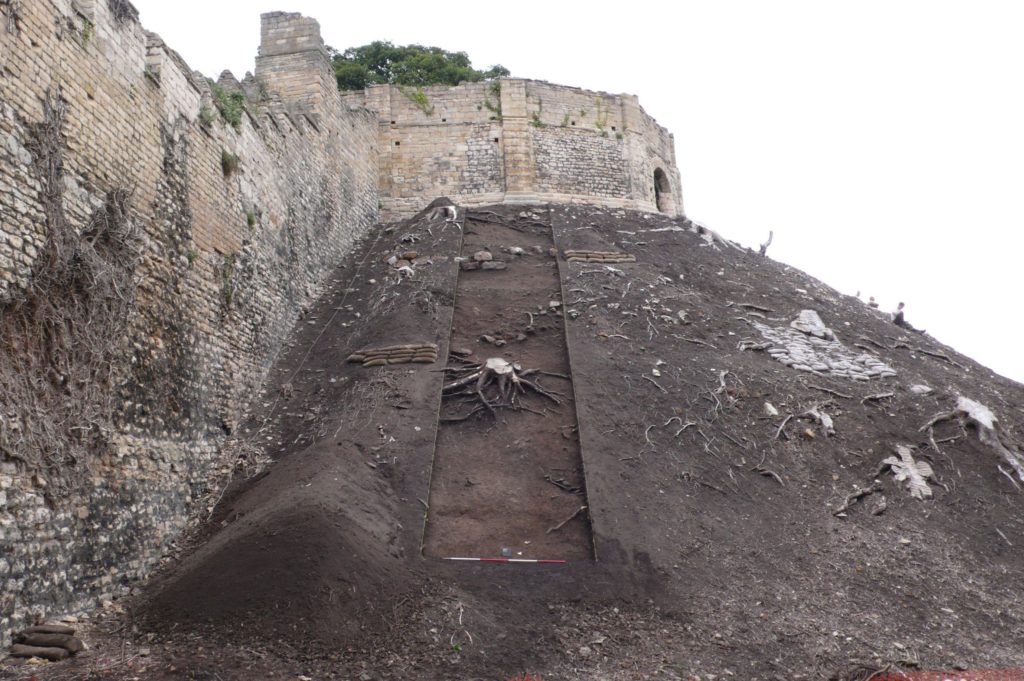
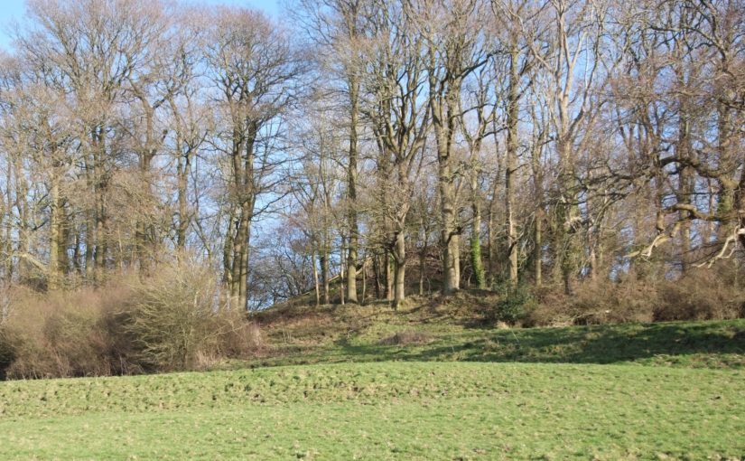
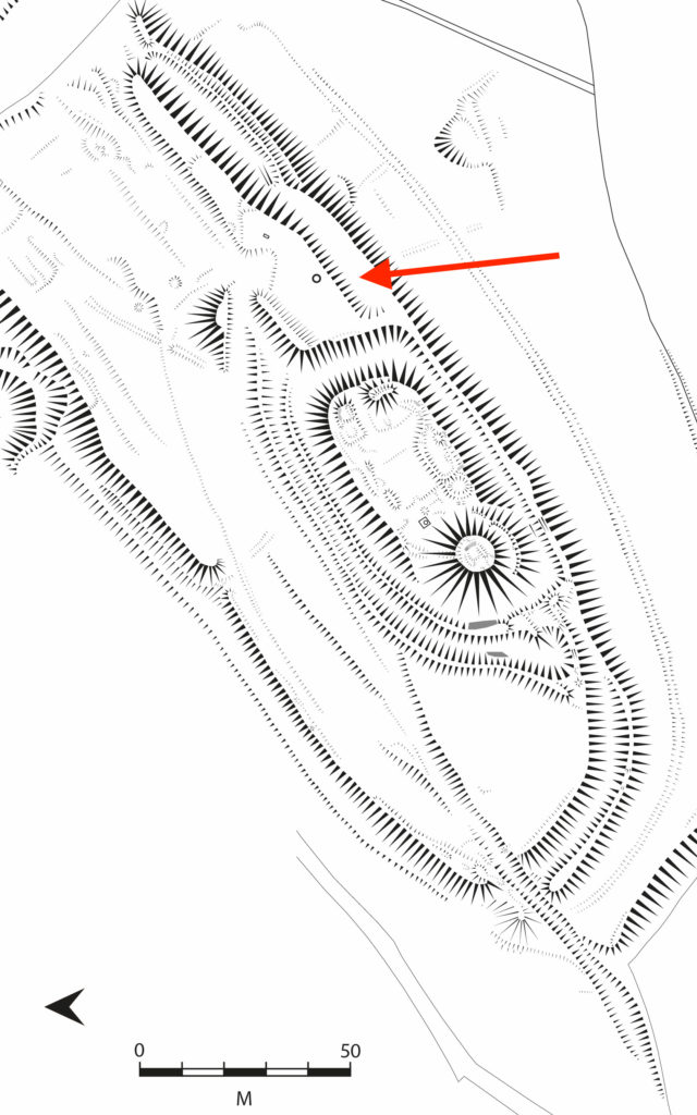
At its medieval height, the Corbet family had constructed an extensive castle complex, with views from the motte, great hall and southern wing of the castle bailey looking out across the wide Rea Valley to their hunting forests of the Stiperstone Hills. While these views would still have been important, archaeologically we can see a shift in investment into creating an immediate garden landscape on the sunny, southern-facing slopes of the castle. The shift away from the monumental defences that defined the medieval castle is demonstrated physically through the infilling of the southern ditch of the castle bailey to create a probable broad planting terrace (Fig 1). It seems probable that this process of creating an ornamental landscape at Caus began in the 16th or earlier 17th century, possibly under the Staffords, or more likely under Joan Thynne and her son Thomas.

Figure 1

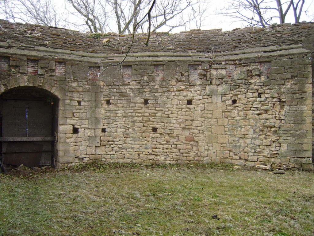
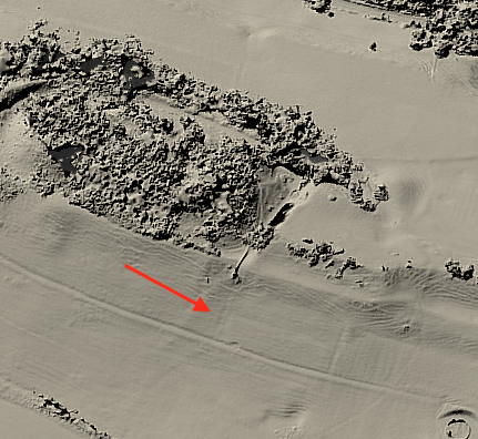
The use of a digital photogrammetric model of the castle, using imagery collected by a drone-mounted camera, proved invaluable in this stage in identifying that further garden features may have extended further south beyond the original bounds of the castle. A square enclosure, fragments of which had been picked up by the ground topographical survey, was clearly visible on the digital model on the southern slopes (Fig 2). While less clear in function than the garden terrace, this feature would also seem to fit within an expanding garden complex.

Figure 2

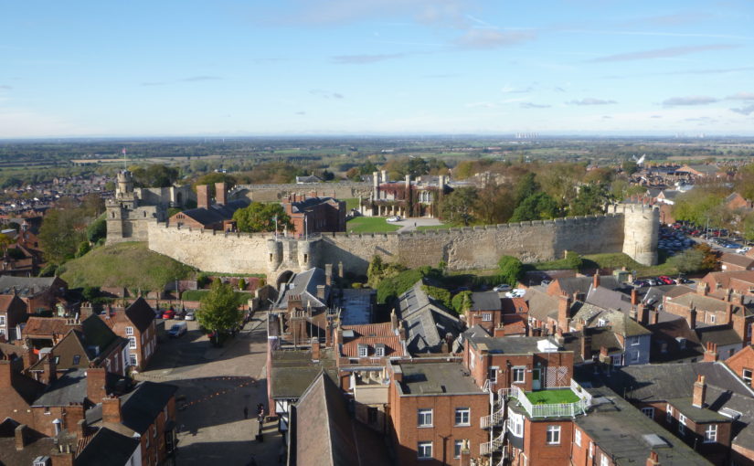
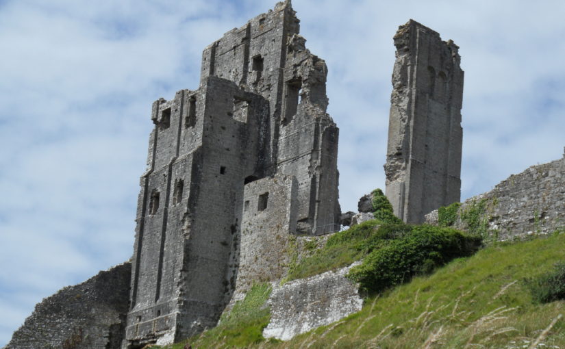
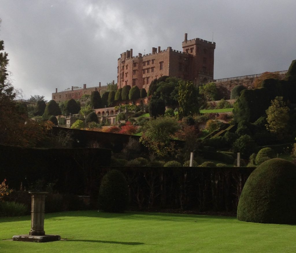
While the totality of these garden features would seem small in comparison to earlier and contemporary examples of elite gardens developed around castle sites, as well as former monastic complexes and new country houses, Caus Castle was not a central residence of the Thynne family, which centred on Longleat in Wiltshire, and should also be seen potentially as a work-in-progress as a developing ornamental landscape. If investment had continued at Caus as an elite residence, we could perhaps draw a broad analogy with the development of Powis Castle in terms of a castle revival in the 17th century, in a geographically peripheral location that ornamentally made full use of its south-facing slopes (Fig 3).


Figure 3

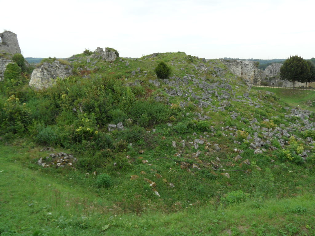
Elite investment in Caus Castle appears to have ended in the 17th century, and while we are deprived of seeing what it may have become if it an been maintained as an elite residence and associated landscape, that development would have potentially destroyed much of the evidence of the medieval and earlier evidence. This snapshot of a castle in flux in the earlier post-medieval period does, however, make the site that little bit richer archaeologically.

Subscribe to our quarterly newsletter

Caus Castle is on private land and not open to the public

Ballintober Castle – revealing the past of the former O’Conor caput

In the Castle Studies Trust’s first year of grant awards it gave a grant to survey Ballintober Castle in County Roscommon, caput of the O’Conors. Project lead Niall Brady explains below how that work has been built on and what has been discovered since.

The Castle Studies Trust grant of 2014 for Ballintober Castle permitted a detailed baseline topographical survey of the 14th-century Anglo-Norman castle, constructed in the early 1300s by Richard de Burgh, earl of Ulster, and taken over by the O’Conor kings of the Connacht before the end of the century, after which it became the caput of the O’Conor Don line and was lived in continuously until the O’Conors abandoned the castle for more suitable accommodation at nearby Clonalis House in the 1700s.

Subscribe to our quarterly newsletter

Location of excavation cuttings 2015-2018, by Dan Cearley

The castle remains a striking ruin in the small village of Ballintober and access to the site is prohibited because of its dilapidation. The 2014 survey feeds into a long-term plan by the O’Conors who retain ownership to rehabilitate the site so that it can be accessible once again and enjoyed. Since 2015, the Castles in Communities research fieldschool has taken a leading role in developing this initiative as a community-engaged anthropological and archaeological Summer fieldschool that sees groups of up to 70 students and staff coming over from America in July, working closely with the O’Conors in Clonalis House and the village represented by the Ballintubber Tidy Towns organization. Additional survey, coupled with geophysical survey, field survey and excavation has made great strides in revealing the complex history of the castle, while a conservation management plan for the castle was completed independently in 2016.

The fieldschool’s work has also extended outside the standing walls of the castle. In reaching eastwards across the present-day village, the project has confirmed the presence of a deserted settlement that would have been integrally related to the castle. In short, Castles in Communities has revealed the deserted manorial village that was associated with the castle and the findings indicate that the medieval settlement footprint was fully twice the size of the present-day village. Excavation within the deserted settlement area is focusing on taking cross-sections across former property plots and the houses within.


Photograph of cutting opened along the castle entrance in 2019, where evidence for two principal phases of construction have been identified. Siobhan Boyd, project director, explaining the findings.

Excavation inside the castle has progressed along the east side of the interior, where perimeter walls are lower and there is no risk of destabilizing standing remains. Attention has focused on the corner towers, and the perimeter wall. The southeast corner tower is circular in plan but its interior was robbed-out at some point in the past, leaving only a narrow and thin occupation deposit that retained post-medieval ceramics. The northeast corner tower is rectangular in shape, and excavation revealed a large building joined to the tower and running south from it. That building is late in the construction sequence and is itself joined to an earlier masonry structure that lies inside the walled perimeter. The indications for an early phase of castle building that might pre-date much of the standing perimeter walls is also indicated at the castle entrance, where excavation has begun to reveal two distinct phases of construction.

Subscribe to our quarterly newsletter

The project will continue in 2021 after Covid-19 restrictions are lifted.

Niall Brady

Project Director (one of 6)

Castles in Communities

https://sites.google.com/view/irelandcastlesincommunities

email: nbrady@adco-ie.com

Lincoln Castle Revealed – The 3-D Reconstruction of the 12th-Century Castle

In its latest round of grants the Castle Studies Trust funded an ambitious 3-D reconstruction of the 12th-century form of Lincoln Castle. Project lead, Jonathan Clark, explains the background to and aims of the project.

Lincoln Castle is one of England’s great castle complexes, developed during an initial intense period of use which straddles the Conquest through to the first half of the 13th century.  The reconstruction builds on the work of the recent Lincoln Castle Revealed project, which involved the conservation and repair of the castle fabric and bailey buildings, the creation of a new exhibition space, and provided a wealth of opportunities for research-led archaeology.  The results of the archaeological campaign – which encountered remains from every century from the 1st to the 20th – have greatly enriched the story of the site as a whole.

Subscribe to our quarterly newsletter

Archaeological investigations encountered elements of the Roman fortress and later Roman Upper City, the defensive enclosures of which appear to have shaped future land-use patterns well into the medieval period, including the form of the castle. The west and south Roman walls stood long into the medieval period; indeed, parts of the western defences still stand to the south of the west castle wall. The southwestern corner of the Roman fortress provided the western and southern extent of the castle bailey.

Surveying the Observatory Tower.  While the current external appearance of this tower is entirely due to changes in the 1830s, the interior fabric still retains important evidence as to its earlier form.

The main development of the castle in stone appears to be from the 1080s into the mid 12th century, a period which will be captured by the reconstruction.  This campaign of work included the construction of East and West Gates, the stone enclosure of the bailey, the 12th-century Lucy Tower shell keep, the development of internal ranges against east and west curtain walls, adjacent to the gates, and a hitherto unknown South Gate.  The South Gate position has been identified in the fabric of the south curtain wall, while its appearance has been confirmed by an early draft plan of Lincoln by John Speed, dated to 1607.

The Lucy Tower Motte after the removal of dense vegetation.  The fragmentary masonry remains of a structure can be seen towards the top of the trench.

The investigations also provided valuable new information about the form and development of the main shell keep (the Lucy Tower) and the southeastern tower (known from the early 19th century onwards as the Observatory Tower).  The Observatory Tower, which briefly upstaged the Lucy Tower during the Anarchy years of the early 12th century, was originally detached from the rest of the castle bailey by a substantial ditch.  This ditch featured a stone revetment on the tower side which was carried up to encase the lower part of the mound on which the tower sits.  The tower was subsequently remodelled to serve as gaol tower.  More is now known of the Lucy Tower including the form of the roof, openings and the arrangement of rectangular chamber blocks, or turrets, to the east and west of it.

A segment of the interior wall face of the Lucy Tower.  The small sockets are putlog holes, while the large blocked sockets housed timbers that joined with a timber ring-beam.

The remains of the main castle hall and various service buildings were also investigated as part of the Lincoln Castle Revealed project.  Their positions are now accurately plotted within the castle bailey and these buildings are being added to the 3-D reconstruction.

A book on the archaeological discoveries from the project is forthcoming but the 3-D reconstruction will allow all to visualise an explore Lincoln Castle at its zenith.   The reconstruction is being prepared by Pighill Archaeological Illustration advised by the Lincoln Castle Revealed archaeological team.

Subscribe to our quarterly newsletter

All pictures in this article are copyright of the author of the article Jonathan Clark

Name that castle – the answers

How many did you get right? Here are the answers to last week’s quiz:

1) Corfe

2) Blarney

3) Chateau Gaillard

4) Chepstow

5) Tibbers – where the geophys survey discovered the limits of a smaller enclosure indicating earlier occupancy than previously thought. You see the full report here:

https://www.castlestudiestrust.org/Tibbers-Castle.html

6) Bolton

7) Coucy. The great tower in the picture was blown up by the vengeful German army division that occupied the site during WW1. All that remains of it is this:

8) Stirling

9) Berkhamsted

10) Ruthin. You can see the amazing video fly-through of the reconstruction here:

11) Newcastle

12) Caerphilly

13) Helmsley

14) Dartmouth

15) Ravenscraig. You can see the video here:

16) Askeaton

17) Dover – east gate

18) Tynemouth

19) Pierrefond

20) Laughton. The links to both reports are below:

https://www.castlestudiestrust.org/Laughton-en-le-Morthen.html

Subscribe to our quarterly newsletter