Project lead of the 2022 project Dating the Medieval Towers of Chalkida, Greece, Dr Andrew Blackler, gives an update on how work on the project has progressed.
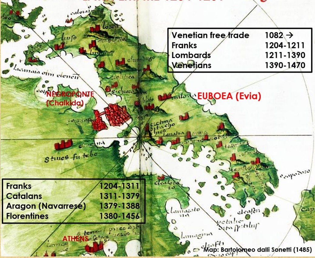
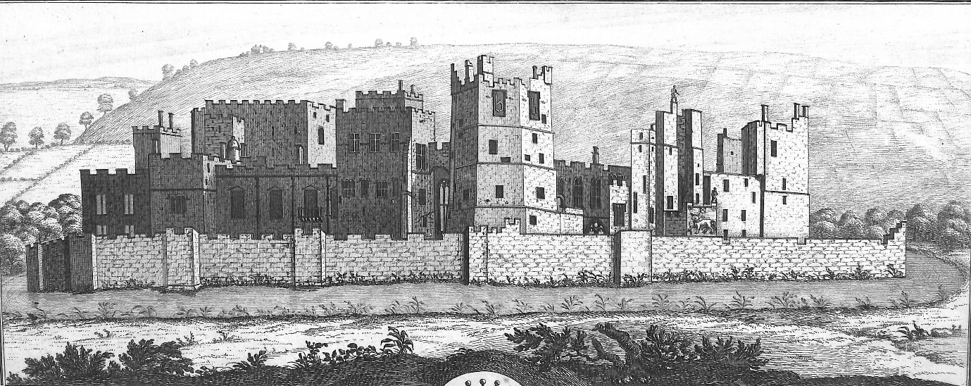
Mention the Acropolis to anyone and they will probably immediately identify it with Greece. Yet the Norman invasions of Greece just fifteen years after the battle of Hastings are almost unknown. Few will know too that the magnificent horses adorning St Mark’s Basilica in Venice were pillaged from Constantinople in 1204, and that much of Central Greece and its islands were ruled for nearly three hundred years by a succession of western adventurers from as far away as Catalan Spain, until the region’s annexation by the Ottoman empire at the end of the fifteenth century. This is simply illustrated in the figure below, based on a map of Central Greece by the Venetian cartographer Bartolomeo dalli Sonetti c.1485. at a time when Athens was just a small provincial town whilst Negroponte was a major city.
This is the background to the five-year survey of the hinterland of medieval Chalkida (Negroponte) on the island of Evia (Euboea), which I was invited to join by Professor Joanita Vroom of the University of Leiden Dr Alexandra Kostarelli of the Ephorate of Antiquities of Euboea in 2020 – the first major archaeological survey in Greece to focus exclusively on the medieval period. Initially, times were tough as the COVID shutdown and lack of funding restricted our work, but slowly our team established a track record supported by sponsorship from institutions such as the Castle Studies Trust (2022).
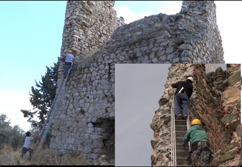
This project, in conjunction with the National Centre of Scientific Research laboratory at the University of Athens, undertook the radiocarbon dating of sections of wood taken from within the walls of a group of medieval towers, a ubiquitous feature of the region. It was very successful. For the first time we were able to conclusively prove that the more than one hundred towers, that once stood on the island, were not built immediately after 1204 as part of a colonial process of control and exploitation, but during the fourteenth century, probably to protect local villages against pirate attack from the sea, an endemic problem of the era.
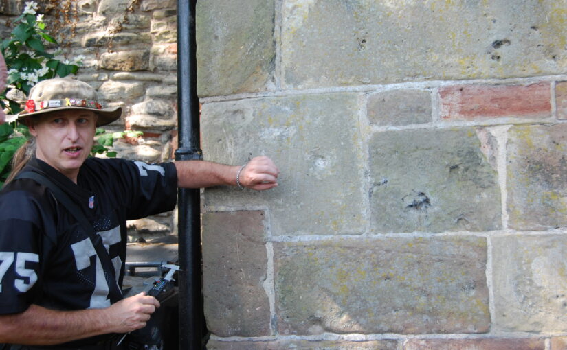
Figure 2: Taking wood samples from a tower, copyright Dr Andrew Blackler
During five years of work over the summer months our team of over thirty specialists and student volunteers has now recorded all the known medieval monuments of the region. Using intensive surface survey techniques and trial excavation trenches, evidence from ceramic, coin, glass, iron, fauna and bone finds is slowly allowing us to reconstruct a picture of the medieval life of the region. Trading links have also been identified east as far as the Black Sea and Palestine, and west to other centres around the Mediterranean. More recently, we have attracted major sponsorship and are now undertaking geophysical surveys to identify structures hidden under the earth, digital reconstruction of selected monuments and have even instituted a second phase of radiocarbon dating. In parallel, specialists have been investigating the medieval archives of the Republic of Venice and Ottoman administrative records held in Istanbul. A detailed report of the results of the first two years’ survey campaigns can be found at https://poj.peeters-leuven.be/content.php?url=article&id=3293423&journal_code=PHA&download=yes
I will leave you with a final thought: the medieval world, despite the slow pace of travel, was much more inter-connected than people generally believe. Two examples illustrate this. Many know that Harald Hardrada, king of Norway and the last great Viking, invaded England in 1066, and was killed at Stamford Bridge just weeks before the battle of Hastings. Few realise that he made his fortune fighting for over ten years in the elite Byzantine Varangian Guard, and that this had probably helped fund his claim to the Norwegian throne. Recent analysis of finds in the British Museum from Sutton Hoo also suggests that Anglo-Saxon mercenaries were even fighting alongside the Byzantine emperor Justinian in Asia Minor as early as the sixth century. This is the sort of international research that the ‘seed capital’ provided by the Castle Studies Trust has spawned over the last three years.
The final results are in and Dr Andrew Blackler, project lead for the Dating of the Towers of Chalkida, Greece, reveals the surprising findings of the project we funded in 2022 to try and date the hundreds of towers in the region.
In the autumn of 1204 forces of the Fourth Crusade, fresh from their capture of Constantinople, annexed central Greece. Studies have been undertaken of the major fortifications they constructed, but little is known about the hundreds of towers, which are today a ubiquitous reminder to the modern tourist of the medieval period in the region.
The traditional interpretation is that they were built by the incoming westerners- the minor nobility – as part of a process of colonisation, to display and impose their power over the local Greek population. Yet, since no scientific study has ever been undertaken, we could not even be sure when they were built, and therefore why they were constructed or by whom – until now.
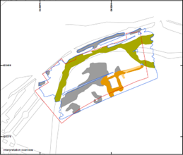
Figure 1: Map of Central Greece with Survey area on the island of Evia (Euboea) and the towers sampled (inset)
Following a two-year research program, funded by the Castle Studies Trust and led by Andrew Blackler, a member of the five-year ‘Hinterland of Medieval Chalkida’ survey, surviving towers in central Greece have now been dated using modern laboratory techniques. In October 2022 a team, including technical staff from the Institute of Nanoscience and Nanotechnology ‘Demokritos’ in Athens and from the Ephorate of Antiquities in Chalkida, took samples of wood and mortar from seven surviving towers on the island of Evia (Euboea). This is the second largest in Greece and runs two hundred kilometres down its eastern seaboard. The island, just seventy kilometres north of Athens, is separated from the mainland by a narrow strait only thirty-nine metres wide, the tidal flows of which even Aristotle failed to solve! Chalkida, its capital, became the Venetian administrative centre (as Negroponte) of its Aegean possessions in 1390 and, following its capture by the Ottomans in 1470, their capital of Central Greece for 350 years until the formation of the modern Greek state.
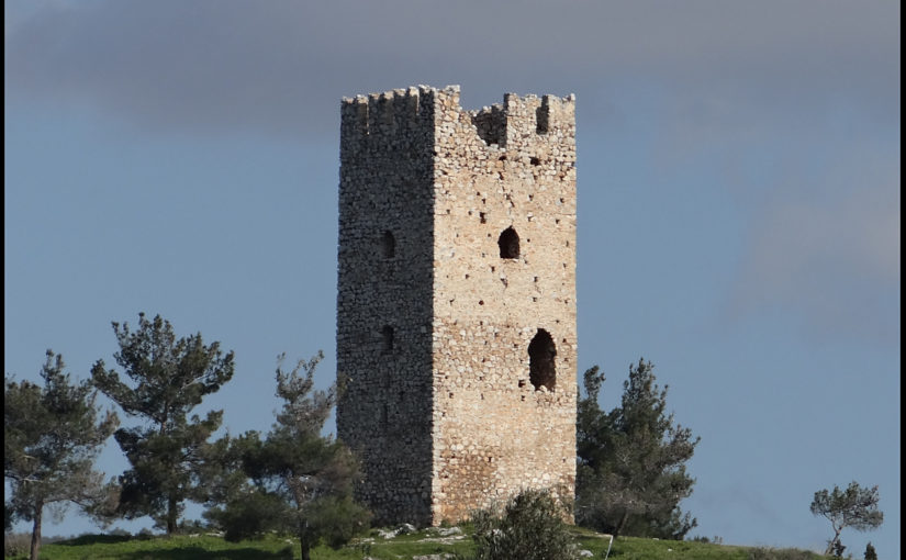
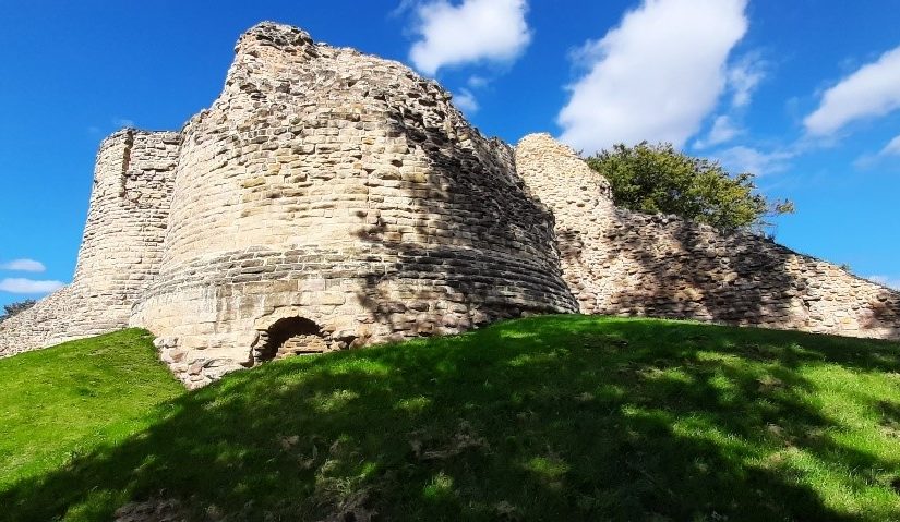
Figure 2. The ruins of a typical tower (Mistros)image description
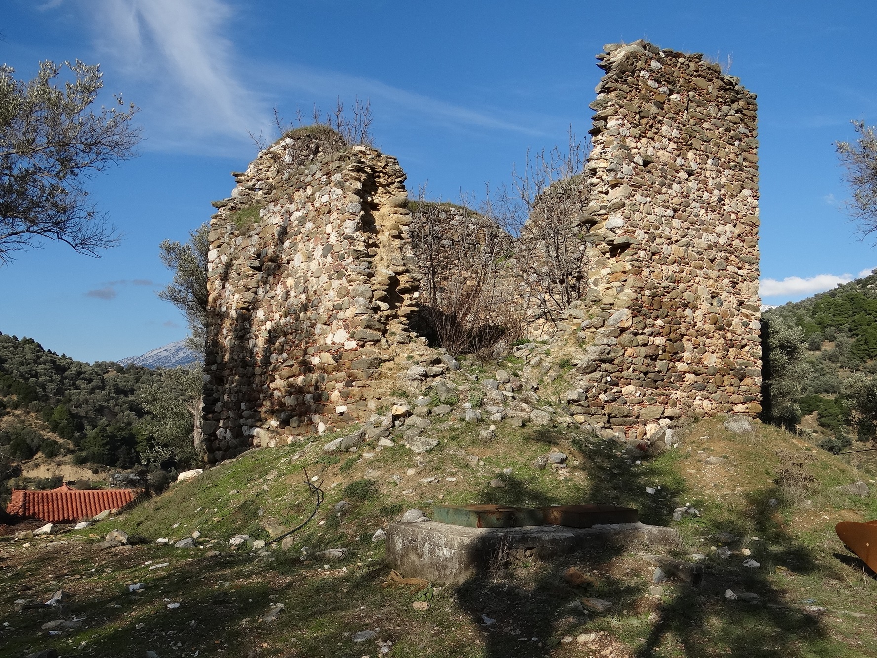
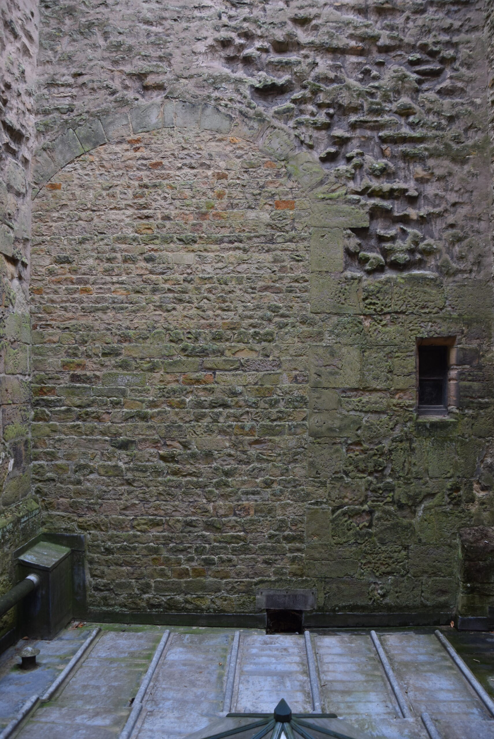
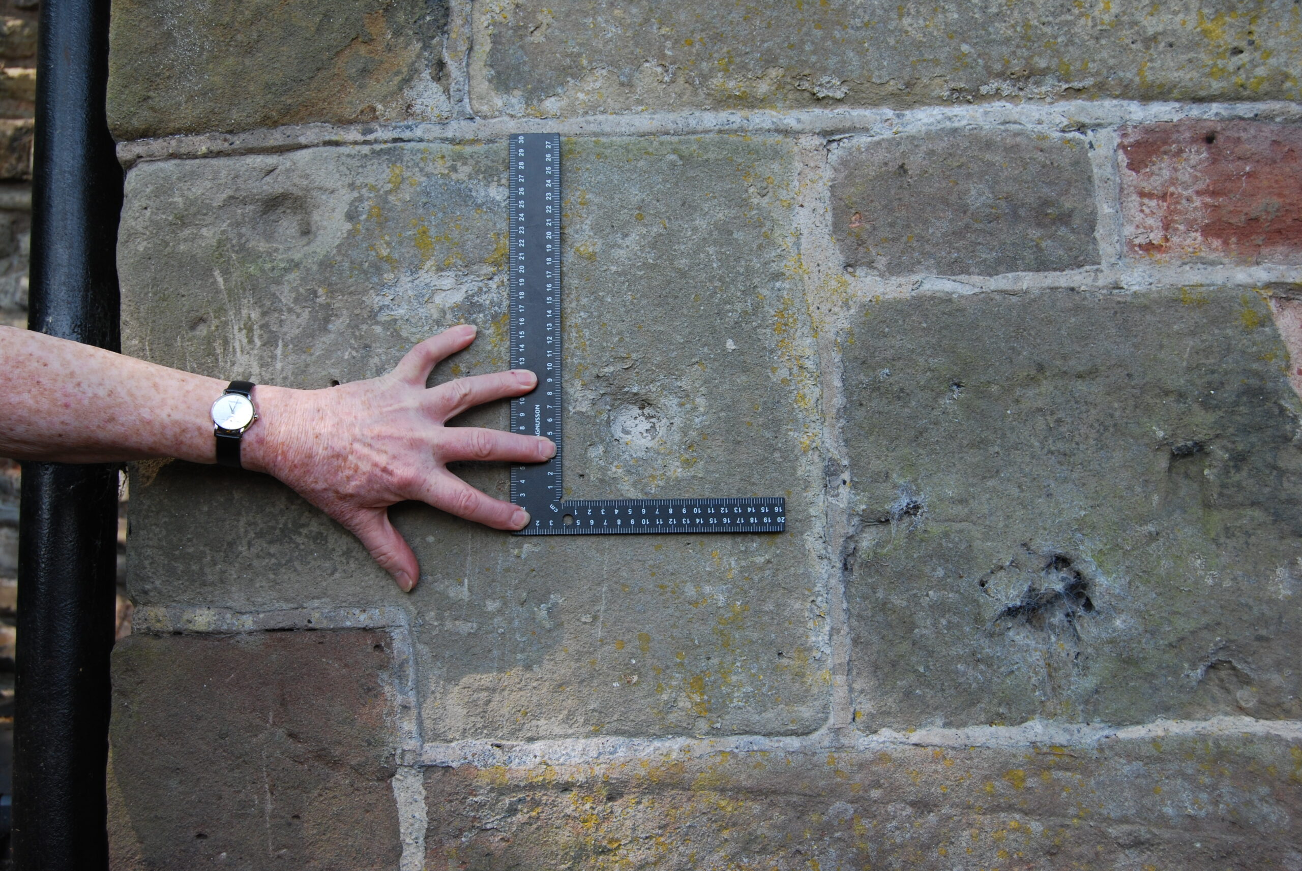
All of the towers (walls about 8 x 8 metres and height up to 18 metres) were in an advanced stage of collapse. Samples were taken of the wood inserted to provide internal lateral structural integrity to their walls, and of the mortar used to bind their rough stonework. This ensured that these materials were not part of a more recent repair or renovation, which would have been the case for beams used to support the multiple floors of the towers, but part of the original construction phase. The ten timber samples obtained were then subjected to a process of radiocarbon (14C) dating, whilst the mortar was analysed using optical and scanning electron microscopy (SEM) and other techniques (pXRF and XRD) at the Demokritos laboratory.
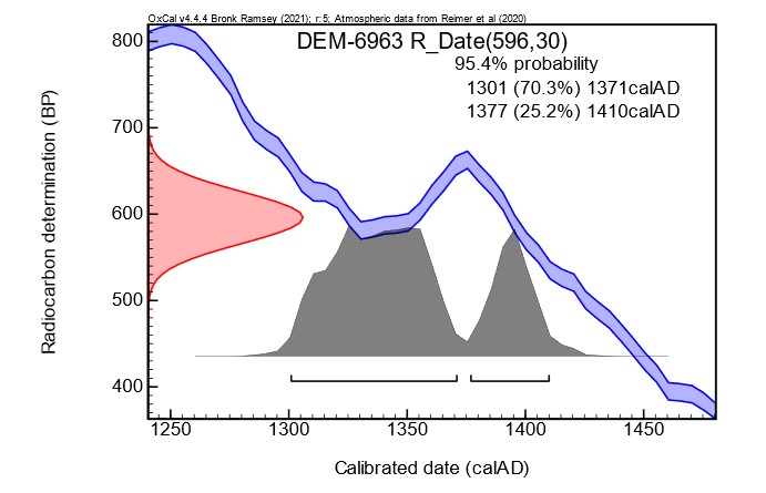
The results have been exceptional. Six towers from different topographic locations (coastal, floodplain, mountain areas) have been dated with 95% certainty to a period between 1270 and 1434. Unfortunately, the accuracy for most samples was only approximately +/- fifty years due to fluctuations in the cosmic concentration of 14C in the earth’s atmosphere caused by solar activity during the fourteenth century: there were therefore two possible dating ranges identified. Two samples were of sufficient quality that, using what is known as ‘wiggle’ analysis, more accurate dating was obtained.
Figure 3. An example of one sample showing the wiggle in the calibration curve, that causes widening of the calibrated ages and splitting of the ranges.
The analysis of the mortar samples also demonstrated that two towers had two phases of construction. It is difficult to know whether this was a deliberate action or simply a reconstruction due to the collapse of the upper levels, given that the region is subject to frequent seismic activity. More importantly, since we could not identify any timber samples for one tower, it was possible to show that the chemical composition of this tower’s mortar was similar to two other towers in its immediate vicinity and thus was possibly also constructed in the fourteenth century.
The general conclusion, therefore, is that all the towers studied were probably built at least a century, or five generations, after the annexation of the region by western forces, and no towers were built immediately after the Crusaders took control. The ’colonial’ interpretation of their role is thus overturned or, at the least, requires reconsideration. Rather, their construction appears to have been a reaction by landowners to increasing instability in the region following invasion of the island by Byzantine forces in the 1270’s, the threat of attack by the mercenary Catalan Company who took control of Thebes and Athens in 1311, and a growing fear of seaborne assault by Turkish corsairs in the fourteenth century.
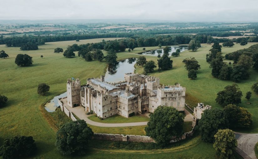
In 2022 the Castle Studies Trust (CST) funded a 3-D digital scan of Raby Castle, County Durham, which was used as a basis for Richard Annis, then of Archaeological Services Durham University, to do a full building survey. Jeremy Cunnington, Chair of Trustees for the CST, takes a look at what he found, focusing on the medieval development of this complicated building that has seen many changes over the centuries, but retains most of its medieval exterior.
Like most castles built and owned by the aristocracy there is no written evidence of what was built when: clues lie in architectural and design features. While exact dates cannot be given, a phasing of what order structures were built in can be shown, much of which agrees with previous scholarship on the castle which suggests that much of the building took place between 1350-88 by the Lords of Raby, Ralph and his son John Neville.
Ground floor plan of Raby Castle. Copyright Archaeological Services, Durham University
A licence to crenellate was granted in 1378 when a lot of the buildings were already in place, as the licence indicates when it refers to “towers, houses and walls”.
The origins of the castle are obscure. The property was obviously substantial enough to be stocked with deer from the royal forest in the mid thirteenth century, suggesting originally an unfortified manor house. Anthony Emery describes Raby as “an awkward and inconvenient shape [that] can only have been determined by an earlier residence on the same low and ill-defended site”.
Raby’s principal purpose has always been residential rather than military with comfortable living taking precedence over defence. The early building seems to be a standard hall house design, with the hall running north to south and utilities and household staff quarters at the north and the lord’s quarters at the south end.
Phase One of the Works
The earliest surviving part of the castle is the Great Hall block. The main discussion relates to whether it was built in two phases or one, with the ground floor being built in the first half of the fourteenth century, and being added to later in the fourteenth century, as proposed by Malcolm Hislop, or was all one build, proposed by Anthony Emery. Evidence for the former is based on the window tracery on the ground floor which is said to date from before 1320.
Blocked first floor doorway in Great Hall block, copyright Archaeological Services, Durham University
Regardless, the main entrance from the courtyard into the Great Hall block from the courtyard was always on the ground floor in a similar position to the current one. The blocked doorway on the first floor was a much later insertion to access an eighteenth century classical loggia. There was no evidence of a staircase down and more importantly the door does not align with the floor of the original first floor hall. Based on an old nineteenth century plan, the entrance to the first floor hall seems to have been a newel (spiral) staircase where the current chapel staircase is now.
Whenever the first floor was added, it was also when the majority of structures on the east side of the castle were built. Both the “Keep” and Mount Raskelf towers at the north end seem to have been built at the same time as the first floor of the great hall given the connecting passage from the first floor great hall to the Keep Tower and probably Mount Raskelf. Although not clear today with the re-arrangement in-fill of Mount Raskelf, both were of mirrored L-shaped design.
Ground floor of Mount Raskelf tower, where the original kitchen was. Copyright Archaeolgical Services, Durham University
The first kitchen was on the ground floor of Mount Raskelf tower. It is also here where there are indications (heavy ribbed vaulting and the plain doorway) that the ground floor of the tower could have been built earlier, but the report found no evidence of a building break.
Equally it looks as though the chapel tower was built at the same time as the upper Great Hall, as it seems that the chapel’s west window, with no evidence of glazing, was intended to allow people in the upper hall to observe, or, given the height of the window above the floor, to listen to services.
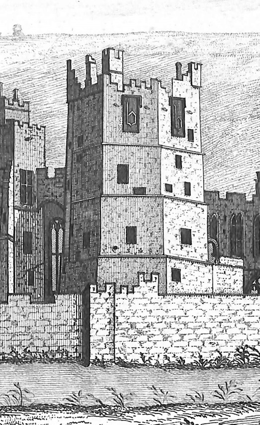
Buck engraving from the south east showing what the original high status rooms of the Great Chamber and Bulmer’s Tower looked like
At the high status (south) end of the hall the accommodation differs from what it was like originally due to the destruction of the chamber block in the eighteenth century. The Buck engraving shows a square great chamber block which was connected to the moated en bec Bulmer Tower with an arched passage way at second floor level. It seems that it was for semi-private rooms for important guests while the Bulmer Tower was the lords’ truly private accommodation, which, in addition to the second floor link, had its own external stair and gate to the south terrace.
It also seems that the Bulmer Tower could date from the same time as the Mount Raskelf tower, as its basement, had the same vaulting as the northern tower according to Hodgson’s 1885 survey. Although no evidence of that now survives.
To the west of the Great Chamber block is Joan’s Tower which had two building phases. Its interior has been much re-arranged so there are no clues to its phasing but it is likely to have been at a similar time to the large expansion around the hall. The older part of the tower was square and had two floors.
Possible blocked postern gate, now in Mount Raskelf tower
Between the original Mount Raskelf and Chapel Towers may also have been the site of an old postern gate at the southern end of the Tower. Although now part of Mount Raskelf Tower the report also suggests that it wasn’t originally, based on later plans, the room in front of the putative gate was originally part of the gate passage and separate from Mount Raskelf . The elongated nature of the gate is also reminiscent of gates at the John Lewyn-designed Bolton Castle.
At some point this gate was blocked up and replaced by an entrance in the Chapel Tower.
Phase Two of the Works
Much of this work took place before the building of the famous Kitchen Tower which couldn’t have been before 1373. The survey shows that the Kitchen Tower was added after the addition of the two northern towers, given that the original kitchens were in the base of Mount Raskelf Tower, and the position of the kitchen which is slightly oblique to the axis of the hall range and northern towers and off centre between those towers. Richard Annis suggests that this is due to the owners wanting to have a service entrance at the south-east corner of the Kitchen Tower but still allow the kitchen’s dimensions to be similar to the kitchen at Durham Cathedral which was completed in 1372.
Roof of the John Lewyn kitchen, copyright Raby Estates
More works took place in the western part of the castle. This was probably when the castle took its current concentric form between 1381-88: the coat of arms on that extension shows the crest of John Neville who died in 1388 and Elizabeth Latimer who he married in 1381. The report assumes the Joan Tower extension, the building of Clifford’s Tower along with the (re) building of the Watch Tower and Western Range took place at this time, as they both extend beyond the original gatehouse to offer protection to the gatehouse or, just as likely, be an aesthetic way to create more space.
Remains of spiral staircase in Clifford’s Tower going from the first to third floors. Copyright Archaeological Services, Durham University
All these buildings have been greatly re-arranged but of them Clifford’s Tower is perhaps the most interesting, given that it was extra lodgings for high status guests. Originally, there was no way to access floors one to three from the ground floor. The only possible access to the first floor was from the West Range, but any evidence has been destroyed by later reworkings. Access to the higher floors seems to have only been possible from the first floor via a spiral stair in the south-east corner of the tower: remains of it were discovered during the survey. No other evidence survives of any other access. There might have been a service entrance from the north yard by a newel staircase and a putative mural passage in the small rooms but that is not certain.
That the (re) building of the Watch Tower dates to a similar period to Clifford’s Tower is based on the design of the two medieval windows in the east wall of the tower, which are paired lights with trefoiled heads identical to the surviving old windows in Clifford’s Tower.
Dating the building periods
It seems likely that, given that so many of the buildings were built simultaneously, which would require large resources, much of the building was carried out by John rather than his father Ralph. While the wealth and importance of the Nevilles of Raby was growing under Ralph thanks to a good marriage and royal service, it was under John that the family’s fortunes really took off. This was particularly thanks to royal service, especially in France from the 1350s onwards. This would have brought great rewards and also allowed him to be influenced by continental styles such as the en bec design of the Bulmer’s Tower. In the early 1370s following the unsuccessful expedition to Brittany he was rich enough to pay ransoms totalling £4,500 for some of his captured companions. It is also likely that it is after that time, when he was back in the north of England, and again from the late 1380s, after a brief stint in Gascony that he would have had the time to devote to the development of the castle and help turn it into the striking castle we see today.
With the final report in the curator of Raby Castle, Julie Biddlecombe-Brown, gives an update on the building survey of the castle the Trust helped fund in 2022 and offers an opportunity for scholars to review it.
In 2022 the team at Raby Castle was fortunate to receive a grant from the Castle Studies Trust to digitally scan the castle exterior. Initially for research and interpretation, the scan has quickly proved to have multiple benefits and uses, and will undoubtedly have more to come. Alongside the scan, Raby (on behalf of Lord Barnard) commissioned an archaeological building survey, carried out by Durham University Archaeological Services and led by Senior Archaeologist Richard Annis, completed last year but updated in January 2024 when able to enter some previously inaccessible areas.
There had been limited scholarly research into Raby Castle in the past; the most comprehensive history having been written by the 4th Duchess of Cleveland in 1870, drawing largely on antiquarian sources. As such, much of the story of the development of the castle has not been verified by current archaeological research methods, so alongside the survey of the fabric, by Durham University Archaeological Services, the castle team set to work exploring the archives and tracking down the sources used by antiquarians.
The site has been occupied since before Domesday Book; the earliest record comes from the reign of Canute when Rabi was part of a gift offered by the King to the shrine of St Cuthbert in Durham. Although no trace of the early medieval structure is in evidence, it is from the later middle-ages, predominantly the 14th century when the castle was owned by the Neville family that the castle developed into the magnificent structure you see today, described by architectural historian Robert Billings in the 19th century as “the most perfect of our Northern Castles, retaining in the mass all its ancient features” … if only it did! Later developments from the 17th century onwards by the Vane family – later Barons Barnard (and even later the Earls of Darlington and Dukes of Cleveland) – who still own the castle today are well documented in the castle archives.
But apart from the castle itself, our sources for the Nevill period are limited. At some point, presumably after the attainder of Charles, 6th Earl of Westmorland for his part in the Rising of the North in 1569 or during the early years of ownership by the Vane family (purchased 1626) the documentary records for the earlier centuries of the castle were either taken away or destroyed.
One of the best early descriptions of the castle comes from the 1540s when it was still owned by the Nevilles. It was sources like this that we were keen to check against the findings of the recent survey. John Leland, in his survey of 1535-1543 wrote …..
“Raby is the largest castel of logginges in al the north cuntery, and is of a strong building, but not set other on hill or very strong ground.
As I enterid by a causey into it ther was a little stagne on the right hond: and in the first area were but 2. tours, one at each end as entres, and no other buildid; yn the 2. area as in entering was a great gate of iren with a tour, 2. or 3. mo on the right hond.
Then were l the chief tours of the 3. court as in the hart of the castel. The haul and al the houses of offices be large and stateley; and in the haul I saw an incredible beame. .. The great chamber was exceedingly large, but now it fals rofid and devidid into 2 or 3 partes. I saw there a little chamber wherein was in windowed of colerid glass al the petigre of the Nevilles: but it is now taken down and glassid with clere glasse.
There is a touer in the castel having the mark of 2. capitale B from Berthram Bulmer.
There is another touer being the name of Jane, bastard sister to Henry the 4 and wife to Ralph Neville the first Erl of Westmerland.
There long 3. Parkes to Raby whereof 2. be plenished with to 92 dere. The Middle Park hath a lodge in it”. (Toulmin Smith, 1907).
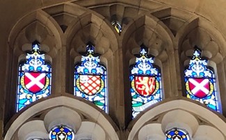
Even with the later alterations to the castle, Leland’s description clearly gives an accurate depiction of surviving medieval structures but also lost features. Pleasingly stained glass windows depicting both Neville crests and those of the families connected by marriage were incorporated in the vast Barons’ Hall extension windows in Burns’s alterations in the 1840s.
The Neville Saltire. Armorial glass added to the Barons’ Hall in the 1840s. Copyright Raby Estates
Equally interesting is the fact that other antiquarian sources appear, thus far, to be generally accurate. Although no trace has been established (yet), it is likely that the earliest structure was an unfortified manor house in the 11th century from which the castle developed ‘organically’, particularly in the 14th century when in phases, a double hall, solar tower, great chamber, private or refuge tower, chapel, postern gate and towers for servants, retainers and guests were added, believed to be the work of the John Lewyn whose hand can be seen in so many north-eastern castles. The kitchen tower is particularly significant, with its high domed ceiling, clearly linking to Lewyn’s work for the Bishop of Durham in the Prior’s Kitchen, Durham Cathedral.
Raby’s remarkable domed ceiling in the Medieval Kitchen
Being in the Durham Palatinate, Raby’s License to Crenellate was granted by Bishop Hatfield in 1378, probably at the end of a phase of fortification which saw the structure emerge as a late contender for a somewhat irregular concentric castle.
How does the castle development relate to the habitation and family fortunes of the Nevilles in this early period? Interestingly, periods of the castle’s development can be linked closely to social mobility, often brought about by advantageous marriages to wealthy heiresses. Around 1176 Isabella de Bulmer married Geoffrey Neville bringing vast land in Durham and Yorkshire to the family. Bulmer’s Tower still bears that family name, adorned with a carved lower case ‘b’ towards its highest points. Later, Elizabeth Latimer, second wife of John, 3rd Baron Neville KG, similarly brought her fortune to the family on her marriage in 1381 and her family coat of arms is proudly displayed on the Neville Gateway – the main entrance to the castle complex along with the Neville saltire and the emblem of the Order of the Garter, a very visible reminder of the position and prominence of the family.
Bulmer’s Tower from a 1723 engraving by Nathanial and Samuel Buck.
External events also had their impact on the development of the Neville stronghold. The wars with Scotland in the 14th century and particularly the Scottish raids south of the border resulted in increased security measures and fortification for those who could afford it. John Neville and his father Ralph had both played a part in the Battle of Neville’s Cross in nearby Durham (albeit John watching as a child): A victory for English troops but a constant reminder of the need for defence.
The ongoing research into the sources that provide context and meaning to the incremental development of the castle work hand in hand with the survey produced by Durham University Archaeological Services. It has been particularly pleasing to begin to explore some of the lost features, from the 3rd ‘court’ (courtyard) now located to the north of the Hall range to the puzzling configuration of spaces above the much-altered chapel gateway. The myth of the earlier towers and particularly the more unusual shape of Bulmer’s Tower have been explored, along with an identification of a list of features lost to 18th and 19th century development.
At the time of writing, our initial plans to incorporate the model in a new introductory film at the castle are well underway. Film makers Heritage Interactive have incorporated views of the castle in the draft film due to be installed for the 2024 season and we’re currently looking at making more use of the model to create a more detailed approach to digitally recreating the phased development of the site. The scan has also been used by the castle’s quinquennial architects and castle team as part of the inspection and maintenance of the castle and master planning for future activity.
Inevitably, the survey report, model and associated research leave us with more tantalising questions, but the report pulls together and verifies a fascinating plethora of information which had previously been scattered, hearsay or completely unknown! Raby welcomes further scholarship and investigation, building on the work of Richard Annis, Durham University Archaeological Services and indeed Raby Castle’s Curation and Archives team. Thanks to all involved! Scholars wishing to consult the report should apply to the curator, via admin at raby.co.uk
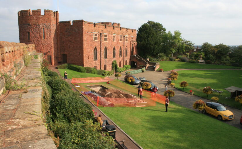
With the excavation report on the third and final season of excavation which the CST has funded now published on our website, project lead Dr Nigel Baker looks at what has been achieved since the first work in 2019 to now.
Just over a century ago Shrewsbury Castle began a new phase in its long life. In 1925 its principal surviving building, having been in use as a private dwelling since the castle was finally de-munitioned in 1686, became the meeting hall of Shrewsbury Borough Council, set in extensive landscaped gardens covering the remains of the motte and inner bailey, the outer bailey having (mostly) disappeared beneath the growing town by c.1300. Shrewsbury Castle remained more or less untouched by archaeology for the remainder of the 20th century. This changed in 2019 with the award by the Castle Studies Trust of a grant for a season of geophysical survey and excavation in the inner bailey. Following permission from Shropshire Council, the site owners, and Historic England, its legal guardians, the work took place in May and July 2019, the geophysics by contractors Tiger Geo and the excavation team made up of experienced local volunteers and staff and students of University Centre Shrewsbury. The results were unexpected.
Shrewsbury Castle Excavation 2019 showing the width of the ditch around the motte using deckchairs (copyright Dr Nigel Baker)Arrow heads found in Shrewsbury Castle Motte Ditch (copyright Dr Nigel Baker)
Immediately under the turf was natural glacial gravel: the top of the hill on which the castle had been built; the ground surface had been lowered sometime in the past, removing nearly all archaeological remains. This was almost certainly the work of the young Thomas Telford who, from 1786 to 1790, lived in and ‘restored’ the castle for its owner, Sir William Pulteney, M.P. for Shrewsbury. However, archaeological strata were found to have survived within cuts into the natural gravel, and two of these were of major significance. The first was the edge of a previously-unknown ditch around the base of the motte. Medieval cooking-pot sherds of late 11th-13th-century date were found in its lowest excavated layers, along with two armour-piercing crossbow quarrel heads. The second significant find was of a pit containing in its fill a piece of decorated bone and two types of pre-Conquest (Saxon) pottery: Stafford-type ware, distributed widely across the emerging towns of the region and already well represented in Shrewsbury; and a limestone-tempered fabric, TF41a, never before seen in Shrewsbury, which had been made in the Gloucester area and probably imported up the Severn. This confirms that there was pre-Conquest activity on the site of the castle, and, along with the Domesday evidence that there was a church of St Michael there by 1086, may point in the direction of a high-status pre-Norman presence on this tactically-significant site controlling access to the ancient borough.
Shrewsbury Castle Excavation 2020 (copyright Dr Nigel Baker)
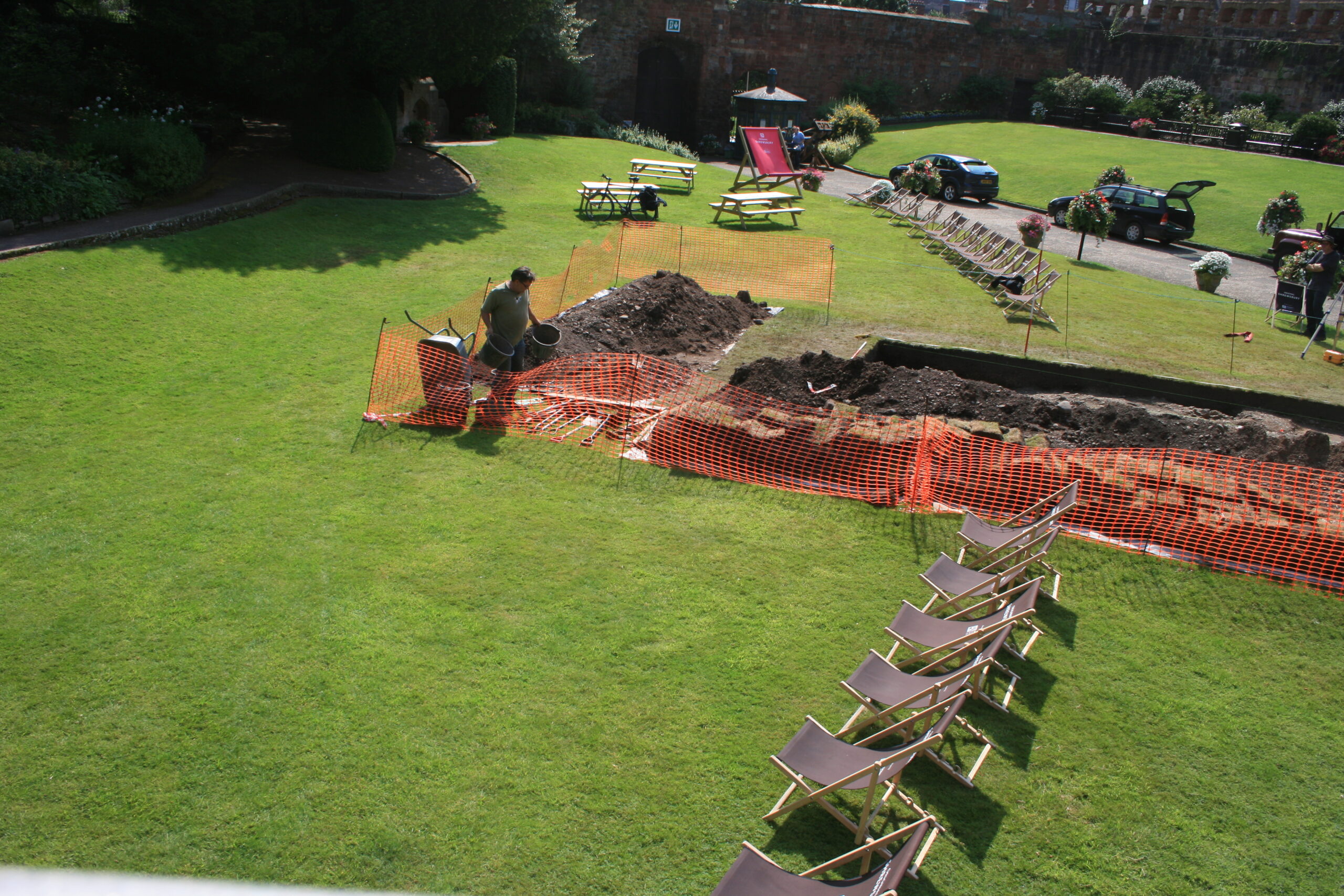
Excavation resumed in the autumn of 2020 with a trench seeking a sample profile through the west rampart of the inner bailey. This turned out not to be medieval in date. Both the west and the north rampart were probably created as part of Thomas Telford’s landscaping work in 1786-90. But, intriguingly, below the west rampart there was no sign within the trench of the natural hilltop gravel found close by in 2019 at a depth of just a few centimetres. The explanation may be that the bailey was enlarged westwards between the Norman period and the later medieval period, by dumping soil and levelling-up behind a new curtain wall.
Shrewsbury Castle Excavation 2022 on the motte top (copyright Dr Nigel Baker
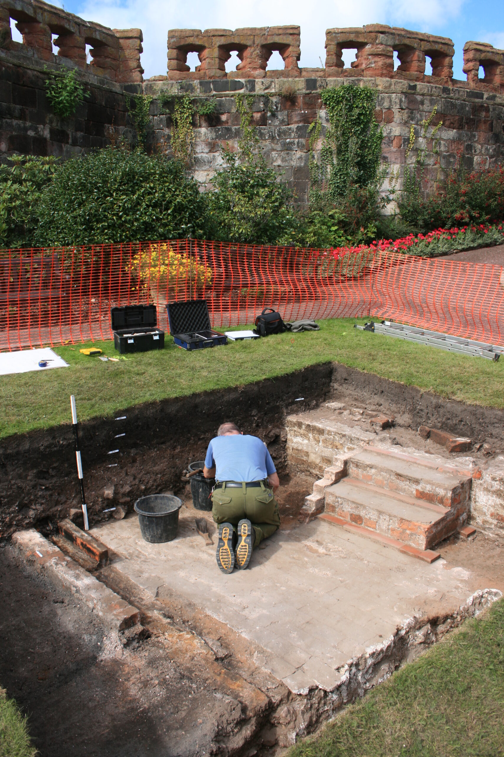
The final season of excavations took place in 2022 on the top of the motte, and outside the north curtain wall. Telford is known to have demolished ruined medieval buildings on the top of the motte and replaced them with the surviving two-storey Gothic summerhouse there. Excavation showed that Telford’s activities had, again, removed most of the archaeology but that the foundations of early medieval timber buildings (beam slots, a post pad, post holes) survived where they had been cut into the motte material. No definite trace was seen of the ‘great wooden tower’ which is documented on the motte top until its collapse in 1269-71.
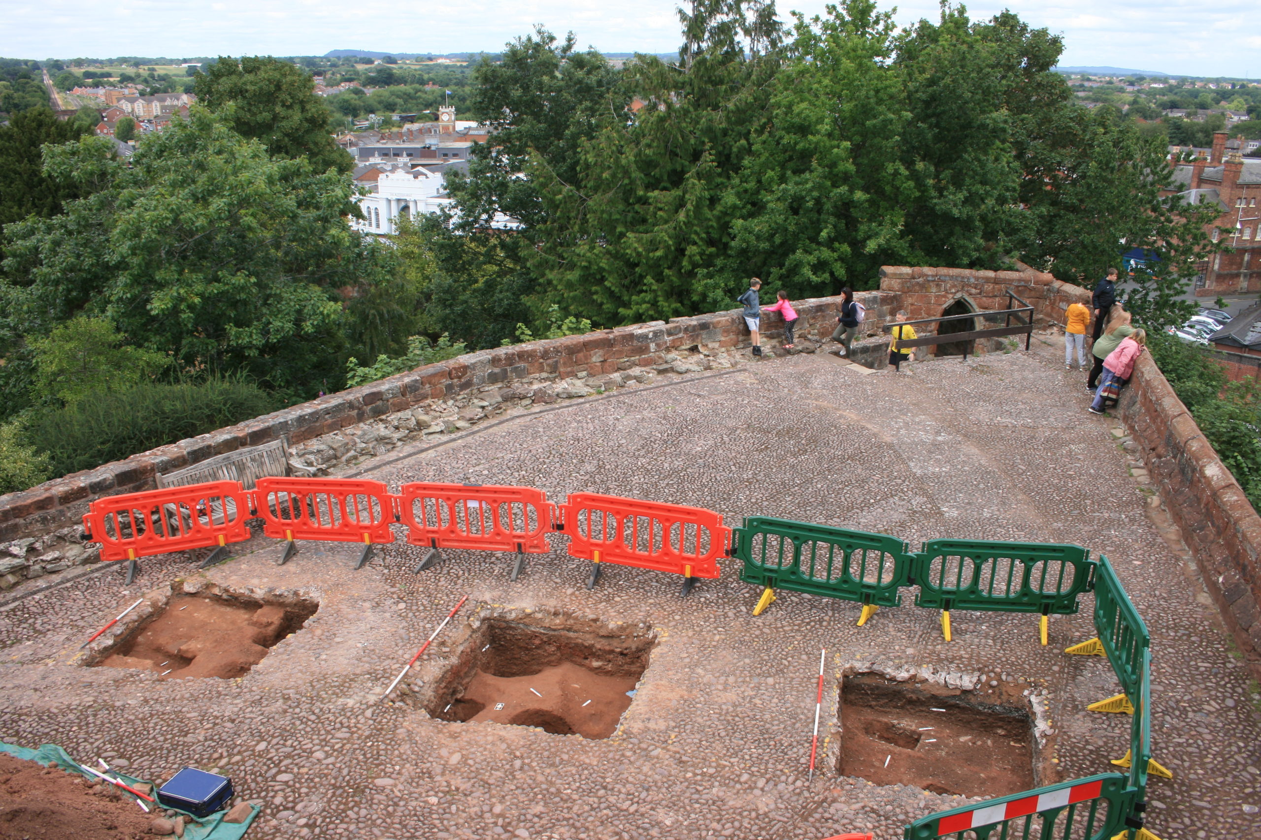
New light was also shed on the motte by vegetation clearance on its south side, revealing for the first time remains of buildings incorporated in the masonry of the retaining walls. This work was undertaken on behalf of Shropshire Council for a new conservation-management plan, currently at consultation stage, which includes photogrammetric surveying of all the castle structures. This permanent stone-by-stone record not only forms the basis for the next vital stage of work – identifying and specifying long-needed repairs – it also offers new archaeological insights, including the identification of the probable primary sandstone rubble fabric of the curtain walls. This was in turn followed by some research carried out by Jason Hurst on Civil War musketry damage in 2023 (Potential shot damage at Shrewsbury Castle – Castle Studies Trust Blog) . And now, the process of publishing this body of new archaeological, architectural and historical information is just beginning…
Jason Hurst from the University of Leicester’s School of Ancient History and Archaeology and expert on civil war damage to castles looks at the damage at Shrewsbury Castle.
In June this year I went with Dr Nigel Baker, and Dr Morn Capper of University Centre Shrewsbury, to examine suspected musket/weapon projectile damage inflicted on the Castle, possibly during the Parliamentarian assault of February 1645.
Dr Morn Capper showing the damage to Shrewsbury Castle’s main gate
When inspecting the marks on the main castle gate I concluded that these were from musket/pistol ball strikes with some indication of possible fragments of these projectiles still embedded in the woodwork, along with possible residues.
Shrewsbury Castle Postern Gate Gun Shot Damage
On the outside of the Postern Gate the identification of some of the marks could not be positively made because of weathering, but intriguing larger impact marks seem to be from a small calibre artillery piece, possible a Robinet or similar sized calibre gun.
At the north end of the hall, facing the railway station, are marks that look like weapon projectile strikes but their trajectory is problematic. Some appear to have come in at a level trajectory towards the wall and some from a downward trajectory, so these need to be looked at in more detail to determine what has caused them.
As the Castle Studies Trust funded part of the project to learn more about Raby Castle comes to a close, the funding of the digital modelling of Raby’s exterior, the castle’s curator, Julie Bidescombe-Brown explores what they have found so far which includes a short preview of the model in its glory.
Throughout 2022, the team at Raby Castle has been working with Durham University Archaeological Services on a project funded by the Castle Studies Trust to drone scan and create a digital 3d model of the entire castle exterior. At the project draws to a close, Raby’s Curator Julie Biddlecombe-Brown reflects on the work undertaken over the last year, including both the planned outcomes and unexpected benefits of the work undertaken.
‘At the time of writing this blog, I am waiting with bated breath for an email that marks the end of a truly game-changing project for Raby Castle. The email will include the final embedded link to a detailed digital model of Raby Castle’s exterior produced over a series of drone scans during the summer months of 2022. The sneak preview given to the castle team was breath-taking. When we applied to the Castle Studies Trust for support for the grant I had no idea of the level of detail that the technology now enabled. My initial application for funding was based on the creation of a digital model that could be used as the basis for future interpretation; a tool for presenting the castle to new audiences. What we have achieved has ended up to be so much more.
For those not familiar with Raby Castle, this beautiful building in the south of County Durham has remained the family home of the Vane family for almost 400 years. Harry Vane, twelfth Baron Barnard is the current owner and along with his wife, Lady Kate Barnard, has set out ambitious plans to ensure the future sustainability of the castle and wider estate. This project reflects their vision, setting out to better understand the estate so that responsible stewardship of rich heritage assets can see the castle enjoyed and studied by future generations.
Going back to the castle itself: from the exterior, it is one of the most intact 14th century castles in the north of England, adapted over the centuries to provide luxurious accommodation for the two families who have lived here. First, the medieval northern powerhouse of the Neville Family who lost the castle after the failed Rising of the North. It was the Neville family who created most of what can be seen today, their license to fortify the castle having been granted by Bishop Hatfield of Durham in 1378. Second, the Vanes, later Barons Barnard, Earls of Darlington and Dukes of Cleveland came to Raby after purchasing the castle in 1626. Over two hundred years later, what remains the castle’s most comprehensive history was written by Catherine Lucy Wilhelmina Vane, the 4th Duchess of Cleveland, in 1870, a formidable scholar and biographer whose engaging narratives combine clear research of the sources available to her, with a delightful peppering of artistic license. Her handbook has also been a useful tool in this project, with descriptions of alterations, anomalies and observations that come with complete familiarity with a site. The Duchess clearly loved the castle and during the late 19th century welcomed guests from across the globe. Earlier generations of her husband’s family down-played the castle’s splendour. Courtier Sir Henry Vane, who bought the castle in 1626 twice received Charles I there; first in May, 1633; and again in April 1639. Charles is said to have been greatly struck by the size of the castle, and to have rebuked Sir Henry for speaking of it somewhat irreverently as a ‘mere hillock of stone.’ ‘Call ye that a hillock of stone? By my faith,’ said he, ‘I have not such another hillock of stones in all my realms.”
Images of Raby Castle have been captured for centuries. Above: 1728 Engraving of Raby Castle from the southeast. Samuel & Nathaniel Buck. These topographical images, whilst subjective and sometimes inaccurate, have provided a valuable source in considering the appearance of the castle in the past. Such images shed light on demolished features, such as the barbican depicted here on the eastern (left hand) side of the castle which then has the potential to be ‘virtually reconstructed’ on the base digital model,
You can judge the latest capturing of ‘the hillock’ yourself, by viewing the model funded by this project. Available to the castle team in multiple formats, from a wireframe for digital manipulation to fully overlaid with photographs for a full ‘photo-real’ view, the scan has created a snapshot of the castle at a moment in time but helps us look backwards into its history and forward, securing its future. The Raby team is working with Heritage Interactive, sector AV specialists to adapt the model to be public facing and engage visitors with the story of the medieval fabric in a new introductory film that we will launch next year. But the model also gives us the potential to add to this; to explore later phases of development in the same way, to isolate, interpret and even digitally rebuild key features that have changed over time, such as the removal of the 14th century barbican in the late 18th century, creating the now slightly confusing Chapel Gateway, or exploring the remains of passages, staircases and windows that make no sense in the current configuration of the building.
The base-line data has multiple benefits – in addition to creating new films, we are exploring 3d printing of a model of the castle in jigsaw puzzle-like sections for use with schools and other audiences – what better way to inspire a new generation of castle enthusiasts than to couple the challenge of a puzzle with a superb digital model? The level of detail will also be of huge benefit to the castle buildings team in monitoring condition, working in tandem with our conservation architects who can now view the fabric almost stone-by-stone. This will, we anticipate, not only help us to detect any building changes that might need attention but will also help us in master planning for the future.
A complimentary annex to the project, funded in-house is an archaeological report by Durham University Archaeological Services that will sit alongside the model. This collation and analysis of source material – including what we have learned about the existing fabric – has been led by Senior Archaeologist Richard Annis who over the course of 2022 has delved into every nook and cranny of the castle – peering under floorboards, climbing disused staircases and opening the door of every built-in cupboard to see what lies behind. This level of survey has never been done and when linked to the model, and an examination of known archival and other documentary sources compiled by a willing group of volunteers, we start 2023 with a far better understanding of this remarkable building than ever before. The report and model will be used together by the castle team including custodian, curatorial, archive and buildings teams, and of course our conservation architects as we care for and interpret the castle and will be available as a resource to scholars and academics, hopefully inspiring future research.
And of course, there is still research to be done! The project may have answered questions but has left us with many new ones. Over the coming months, or should that be years … we will continue to explore some of the puzzles of the building, from the origins of some of the towers, to vertical access routes. But what has changed over the last year is that we now have a superb data set as a starting point. Our thanks go to Archaeological Services Durham University and in particular Richard Annis for bringing their enthusiasm, skills, expertise and inquisitive minds to the project, and also, of course, to the Castle Studies Trust which provided us with the funding to enable it all to happen.
As we draw towards the end of the year, Julie Biddlecombe-Brown, Curator at Raby Castle checks in on the 2022 research project funded by the Castle Studies Trust as this chapter draws to a close.
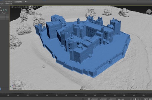
What a busy year 2022 has been and yet, this project has been one of the highlights. Working with Durham University Archaeological Services, the castle exterior was fully scanned over the summer and the scans imported into specialist software that enables us to view and fully manipulate the images. The quality of the scanned images are superb and can be used in multiple applications; as a base model for 3d imaging (shown below) or overlaid with the HD photographic detail to provide a record of every elevation, down to the individual stone, providing inspiration for new visitor-facing interpretation and vital data for the castle architects. The team at Durham University have shared the incredible detail captured on the scans with their counterparts at Raby – demonstrating how the drone was able to access areas that have previously been very difficult to view; testimony to the skill of the drone pilot but also enabling an unrivalled view of the battlements – even into the machicolations.
Alongside the images, Raby Castle has benefitted from the experience and knowledge of Durham’s Senior Archaeologist Richard Annis in reviewing the complex interior of the building against historic plans and research notes compiled by Raby’s dedicated volunteer group. With the scans and historic plans to hand, Richard has explored the building from top-to-toe, focusing on intersections between the medieval fabric and later interventions. This has identified spaces known to the castle team which had not appeared on any of the earlier plans, enabling detailed measurements to be taken as part of the broader survey. In addition to the overall survey which will be of immense benefit for the quinquennial survey and subsequent building monitoring and maintenance, this project sought to produce a 3d digital model of the castle that could be used to demonstrate different phases of the castle’s history. The team at Durham University Archaeological services have produced a Terra model (below) which will now be separated into phases for the conclusion of the project in December. The castle have engaged audio-visual specialists Heritage Interactive to work with them to produce new interpretation for visitors that will incorporate the models and the research findings.
Image of Raby Castle from 3D Digital Model
Special thanks from the Raby Castle team are owed to the Castle Studies Trust Trustees who visited in October to check on progress. The afternoon spent at Raby was valuable for both the Trust and the Castle, drawing on expertise and debating anomalies in the castle architecture. The discussions will feed into the final report being produced by Durham University Archaeological services alongside the model. We look forward to sharing the end results once the final report and model have been completed.
During the summer of 2022, Wakefield Council and Wessex Archaeology undertook several geophysical surveys of Pontefract Castle funded by the Castle Studies Trust. Ian Downes, Senior Heritage Officer at Wakefield Council explains what they found.
We were trying to discover if there were traces of the castle’s rich archaeology hidden under the ground. Specifically, we were looking for several service buildings between the kitchens and Royal apartments which had been mentioned in maintenance records for the castle, Victorian paths listed in ordnance survey maps, as well as any evidence of buried weaponry from the Civil Wars bombardment in the 17th century.
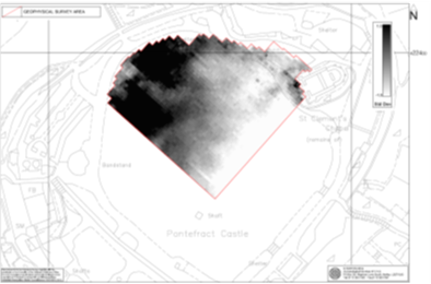
This was not the first-time surveys of this nature had been conducted, most recently West Yorkshire Archaeology Service were commissioned back in 2010.
This image from the 2010 survey shows the resistivity results for the northern half of the bailey and two large but undefined masses of high resistance (ASWYAS)
Three techniques have been utilised here: Resistivity, Magnetometry and Ground Penetrating Radar.
Resistivity measures the ability of the ground to conduct an electrical signal between two metal probes. In its simplest form this gives us a clue about buried walls and ditches, as the latter holds water much better than a wall and the resistivity is lower. This technique is relatively quick, easy and cost effective, but has limited depth and tends to only reveal that which is relatively close to the surface.
Magnetometry, or to be more specific magnetic gradiometry, records tiny variations in the earth’s magnetic field. These could be caused by the filling in of a ditch, a fire or magnetic items in the soil. This again doesn’t have a great depth but can help backup findings from our other two techniques. The ability to spot iron objects on a Civil Wars site that was bombarded by cannon fire is also useful.
Our third method was ground penetrating radar. It uses a form of electromagnetic radiation similar to that used in radios, microwaves and mobile phones and employs the same technology used to detect aircraft. However, instead of sending signals into the air we direct them into the ground and measure how long it takes for those waves to bounce back. The signal bounces back better from solid objects than soil, so it can help spot buried walls or pits, and the time taken to receive the signal tells us how deep down they are
Results
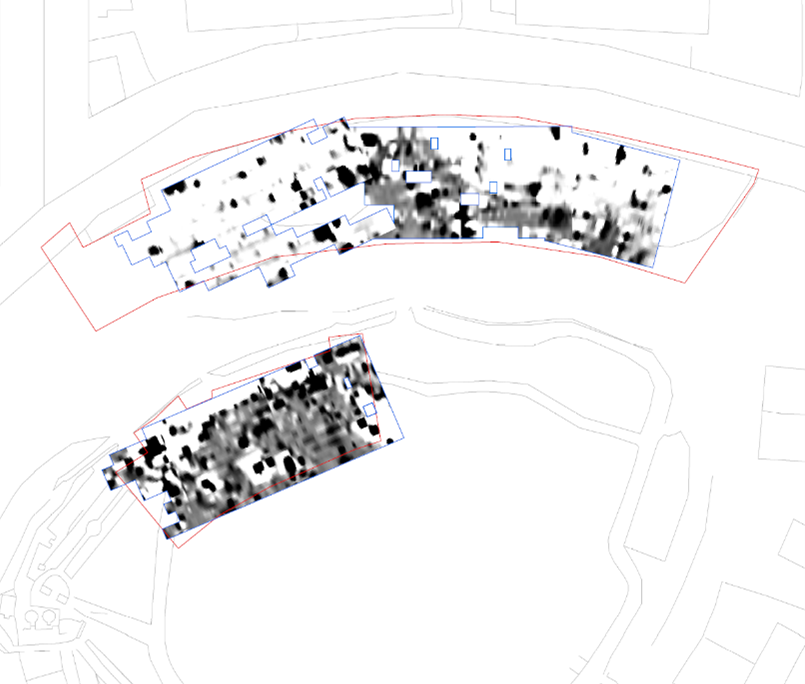
Raw data from the magnetometry results (Wessex Archaeology)
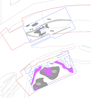
We had varying success with the surveys. Unfortunately, outside the curtain wall, where we hoped to find Civil Wars evidence, the surveys didn’t show any clear results. There were more anomalies below the queen’s tower than elsewhere, but this may be the result of later landscaping works to accommodate the later road around the castle.
The resistivity survey however had more success. Here we can see evidence of the modern paths (pink) and the remains of an elliptical path in the northern survey area which matches the design of a Victorian path system, seen in an 1881 ordnance survey map. No images survive of these paths, so it is exciting to find some evidence of their existence beyond the original plans.
Interpretation of the Resistivity results (Wessex Archaeology)
The final survey technique, using deeper ground penetrating radar, shows a large grey area which is also seen on the resisitivity survey above. Its undefined shape and proximity to the surface suggests it is possibly rubble. However, it’s the dark orange feature about 1m down that is by far the most revealing.
For us, this was an exciting and unexpected discovery, as the design and shape of the structure, including the buttresses on the corners, closely matched a building seen on a 16th century drawing of the castle by Ambrose Cave. He had been commissioned to survey the castle for Queen Elizabeth I in 1560 and it shows a number of buildings along the same section of curtain wall, including the small entrance porch, seen below with the elaborate pinnacles.
Extract from Ambrose Cave’s Elizabethan Survey 1560
We believe it shows a 15th Century chapel that replaced the Norman Chapel which can be seen in the Eastern corner of the bailey. It was assumed from this drawing that it stood away from the curtain wall which can be seen in the background.
However, the design of its entrance closely matches the shape found in the radar survey, including the buttresses on the corners. Its possiblelocation now suggests that it was built against the curtain wall like the other buildings in the castle and was perhaps shown just forward of it for simplicity.
To have been able to finally locate this building and with such clarity and certainty is an exciting discovery for us. This new evidence adds to our knowledge and understanding of what used to be one of England’s greatest castles and will help to inform future interpretation of the site, provide a focus for potential future fieldwork and finally solves the mystery of where the 15th Century chapel actually is!
We are extremely grateful to the Castle Studies Trust for their funding which allowed us to carry out the geophysical surveys. We also acknowledge the support of Wessex Archaeology and West Yorkshire Joint Services in the production of this article.
You can find out more about the project in our short videos which can be found on the Castle Studies Trust Youtube channel
Back in May the geophysical of survey took place at Pontefract Castle. Find out what they were surveying and the various techniques they were using to achieve the best results
You can find more about the different geophysical survey techniques in the article we published back in January 2021 by our geophysical survey specialist assessor Kayt Armstrong:
While here is a short taster video of a project yet to properly start – dating the towers of Chalkida in Greece. With permissions having been granted by the Greek government, Dr Andrew Blackler outlines what they will be doing when the fieldwork gets underway in September.