Transforming our understanding of Shrewsbury Castle

With the excavation report on the third and final season of excavation which the CST has funded now published on our website, project lead Dr Nigel Baker looks at what has been achieved since the first work in 2019 to now.

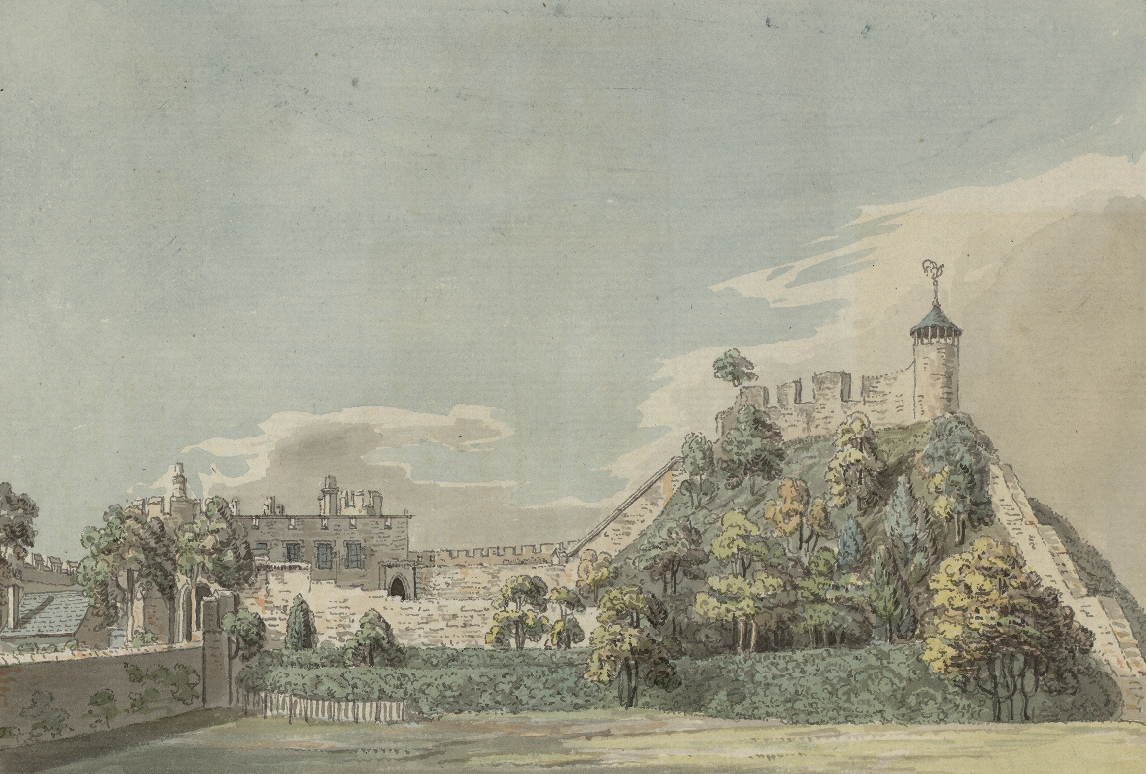
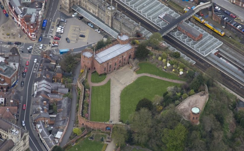
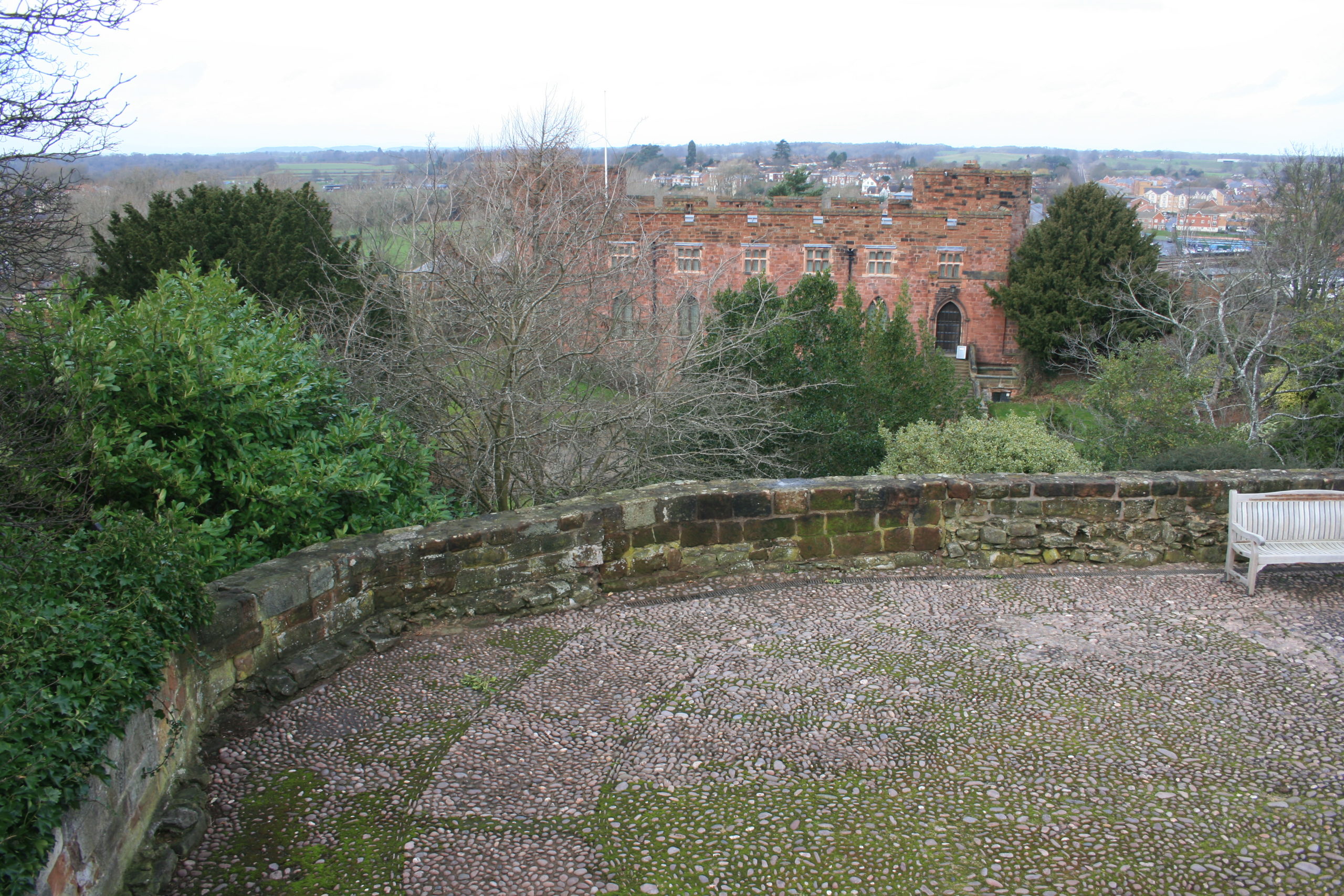
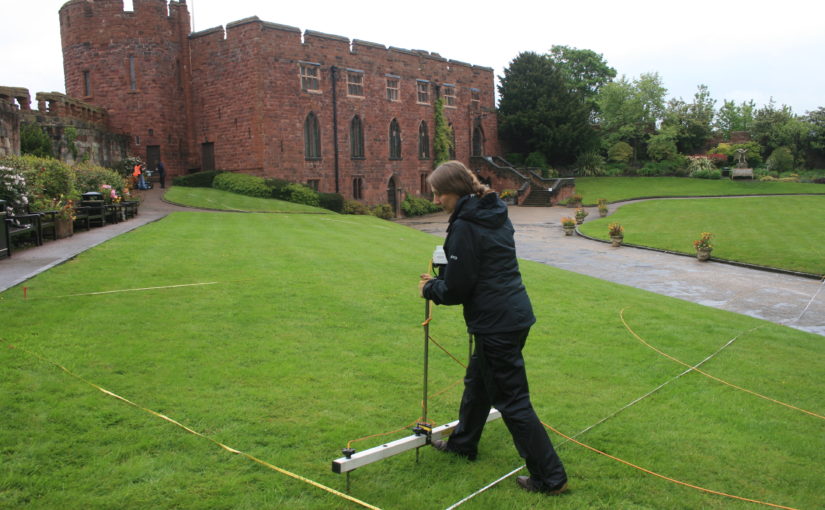
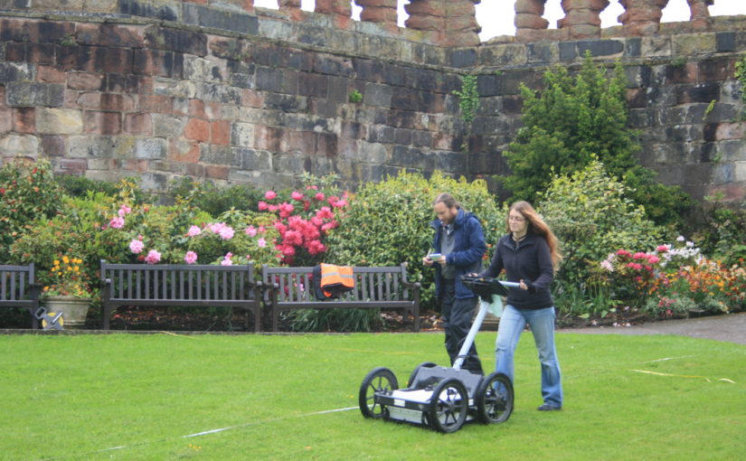
Just over a century ago Shrewsbury Castle began a new phase in its long life. In 1925 its principal surviving building, having been in use as a private dwelling since the castle was finally de-munitioned in 1686, became the meeting hall of Shrewsbury Borough Council, set in extensive landscaped gardens covering the remains of the motte and inner bailey, the outer bailey having (mostly) disappeared beneath the growing town by c.1300. Shrewsbury Castle remained more or less untouched by archaeology for the remainder of the 20th century. This changed in 2019 with the award by the Castle Studies Trust of a grant for a season of geophysical survey and excavation in the inner bailey. Following permission from Shropshire Council, the site owners, and Historic England, its legal guardians, the work took place in May and July 2019, the geophysics by contractors Tiger Geo and the excavation team made up of experienced local volunteers and staff and students of University Centre Shrewsbury. The results were unexpected.

Subscribe to our quarterly newsletter

Shrewsbury Castle Excavation 2019 showing the width of the ditch around the motte using deckchairs (copyright Dr Nigel Baker)
Arrow heads found in Shrewsbury Castle Motte Ditch (copyright Dr Nigel Baker)

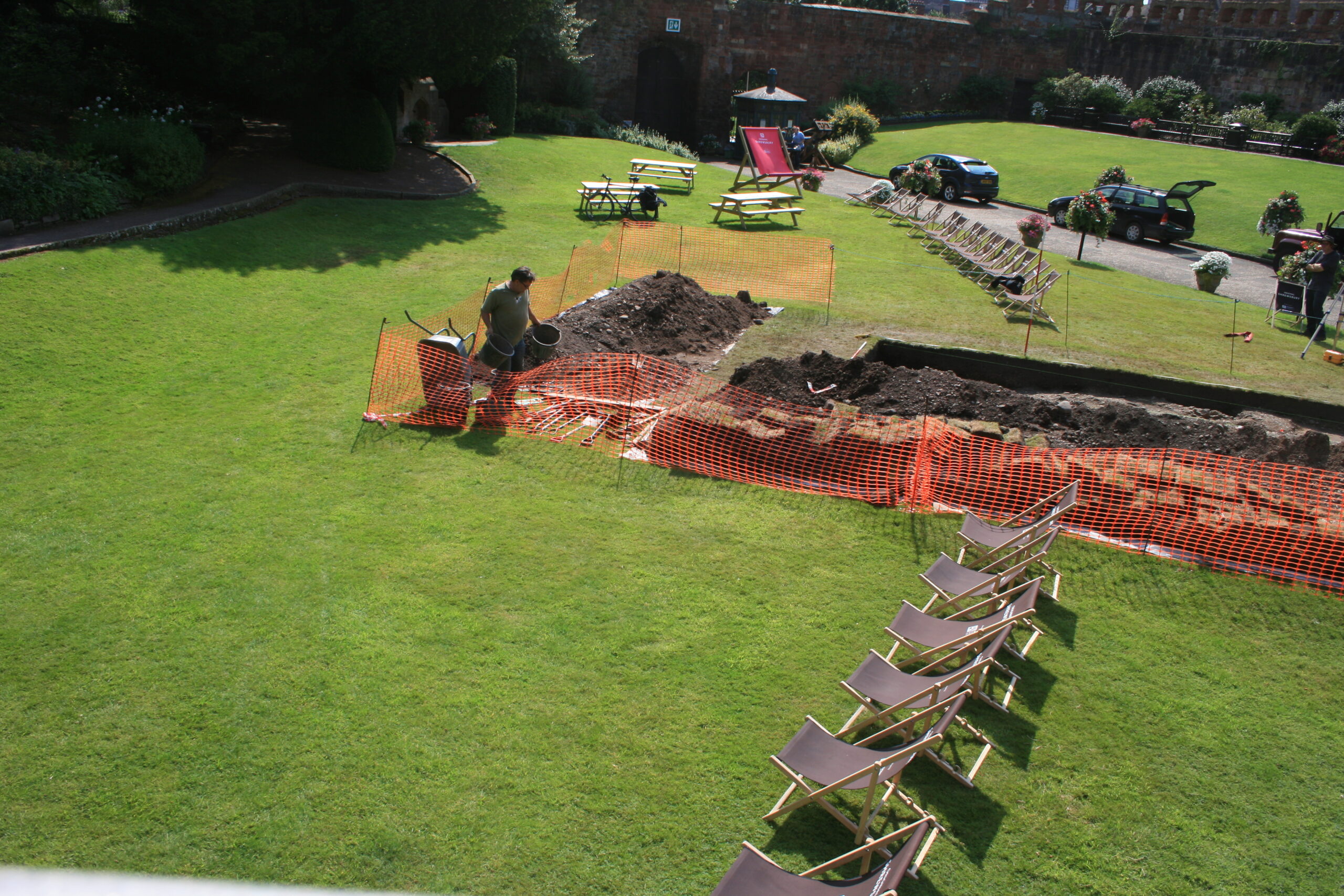
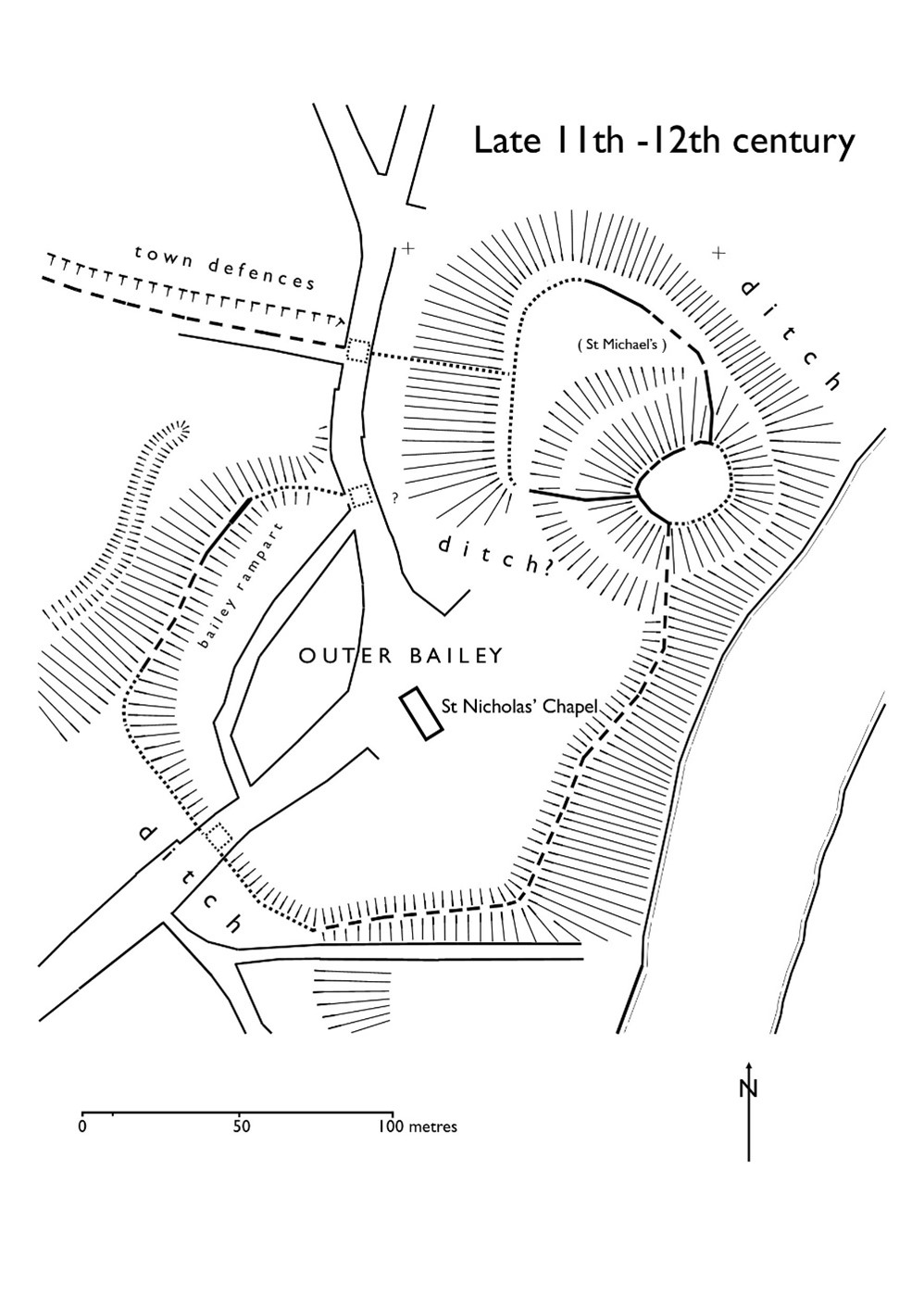
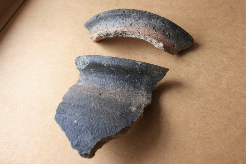
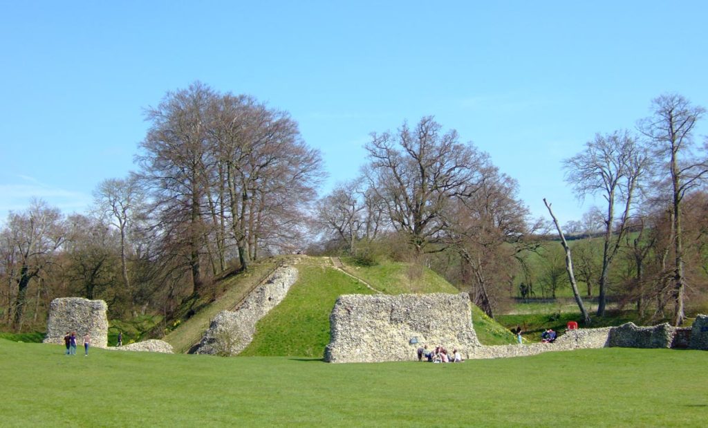
Immediately under the turf was natural glacial gravel: the top of the hill on which the castle had been built; the ground surface had been lowered sometime in the past, removing nearly all archaeological remains. This was almost certainly the work of the young Thomas Telford who, from 1786 to 1790, lived in and ‘restored’ the castle for its owner, Sir William Pulteney, M.P. for Shrewsbury. However, archaeological strata were found to have survived within cuts into the natural gravel, and two of these were of major significance. The first was the edge of a previously-unknown ditch around the base of the motte. Medieval cooking-pot sherds of late 11th-13th-century date were found in its lowest excavated layers, along with two armour-piercing crossbow quarrel heads. The second significant find was of a pit containing in its fill a piece of decorated bone and two types of pre-Conquest (Saxon) pottery: Stafford-type ware, distributed widely across the emerging towns of the region and already well represented in Shrewsbury; and a limestone-tempered fabric, TF41a, never before seen in Shrewsbury, which had been made in the Gloucester area and probably imported up the Severn. This confirms that there was pre-Conquest activity on the site of the castle, and, along with the Domesday evidence that there was a church of St Michael there by 1086, may point in the direction of a high-status pre-Norman presence on this tactically-significant site controlling access to the ancient borough.

Shrewsbury Castle Excavation 2020 (copyright Dr Nigel Baker)

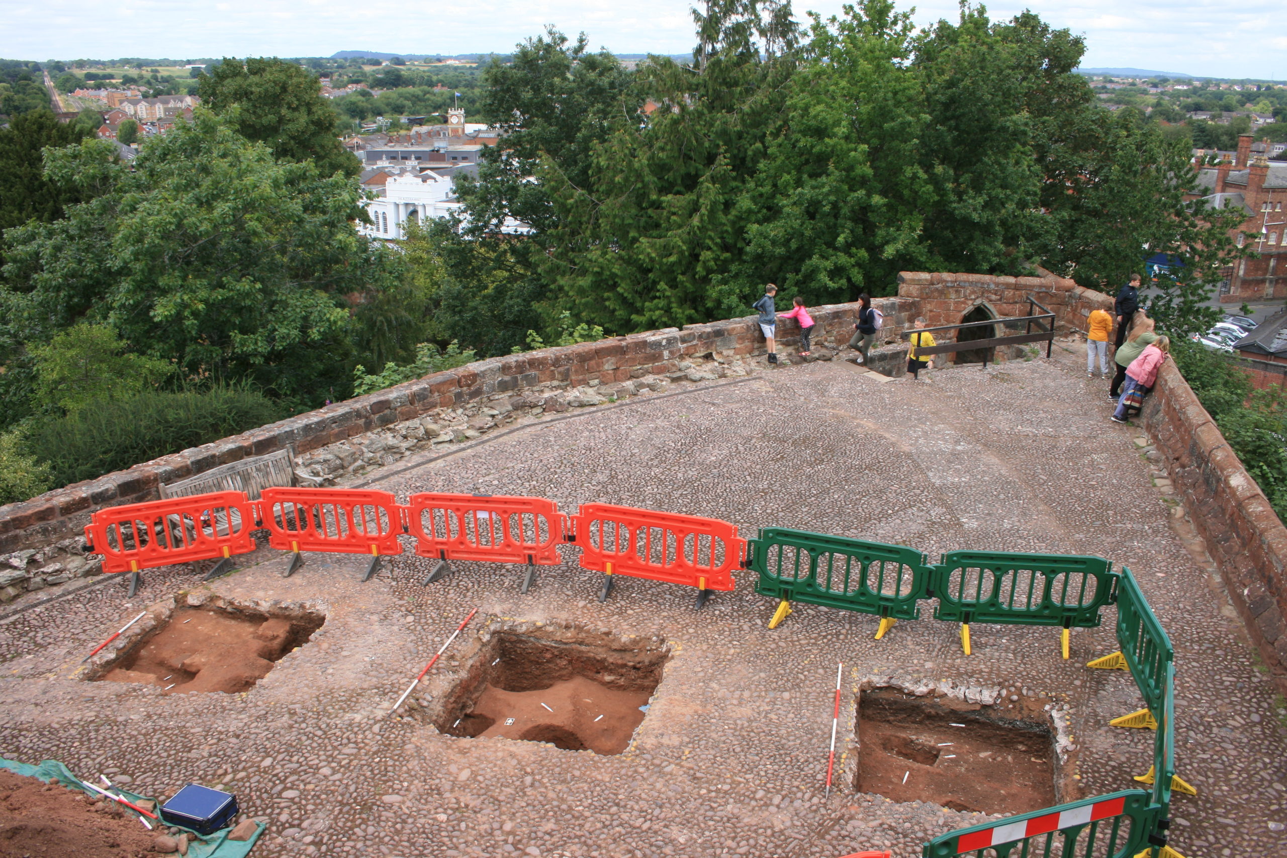
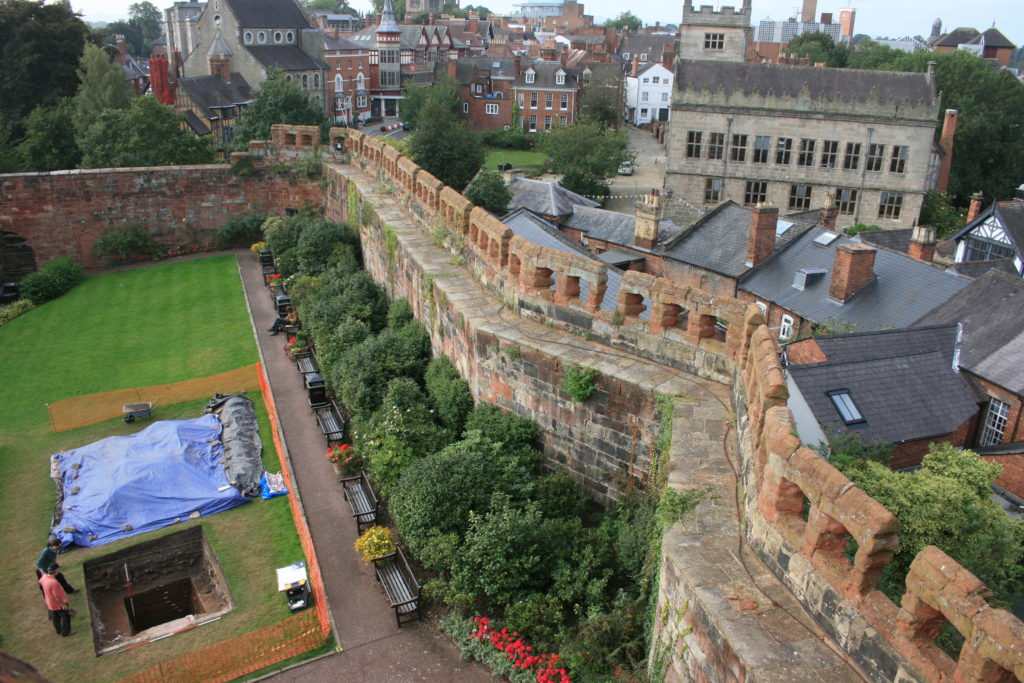
Excavation resumed in the autumn of 2020 with a trench seeking a sample profile through the west rampart of the inner bailey. This turned out not to be medieval in date. Both the west and the north rampart were probably created as part of Thomas Telford’s landscaping work in 1786-90. But, intriguingly, below the west rampart there was no sign within the trench of the natural hilltop gravel found close by in 2019 at a depth of just a few centimetres. The explanation may be that the bailey was enlarged westwards between the Norman period and the later medieval period, by dumping soil and levelling-up behind a new curtain wall.

Shrewsbury Castle Excavation 2022 on the motte top (copyright Dr Nigel Baker

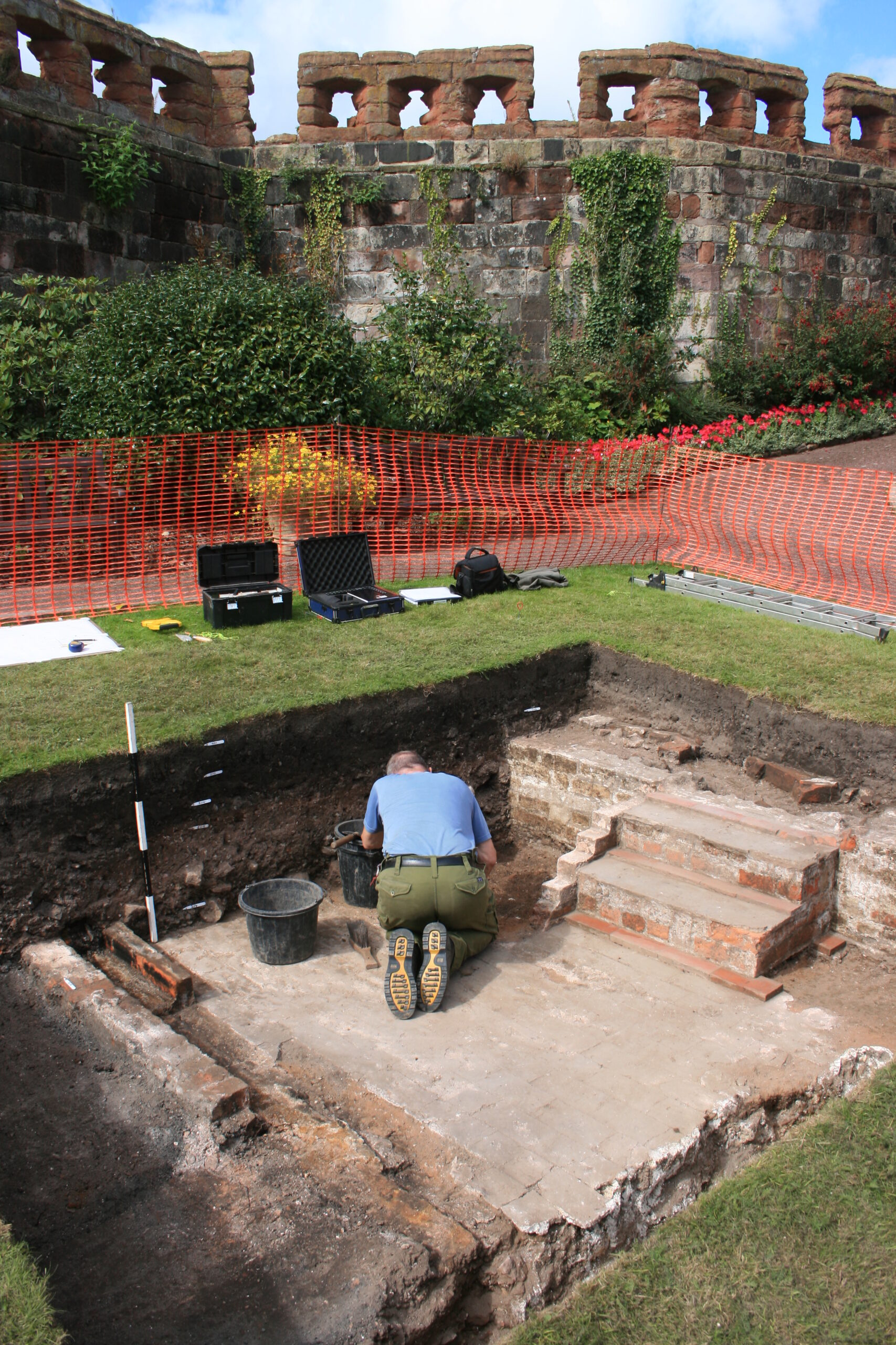
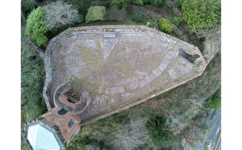
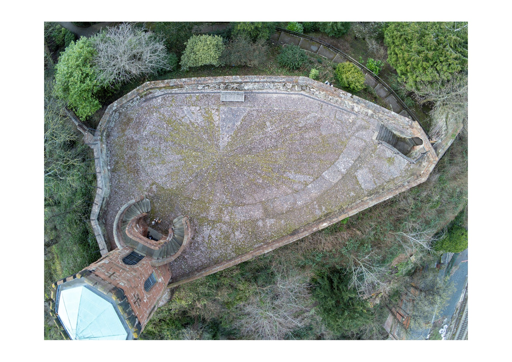
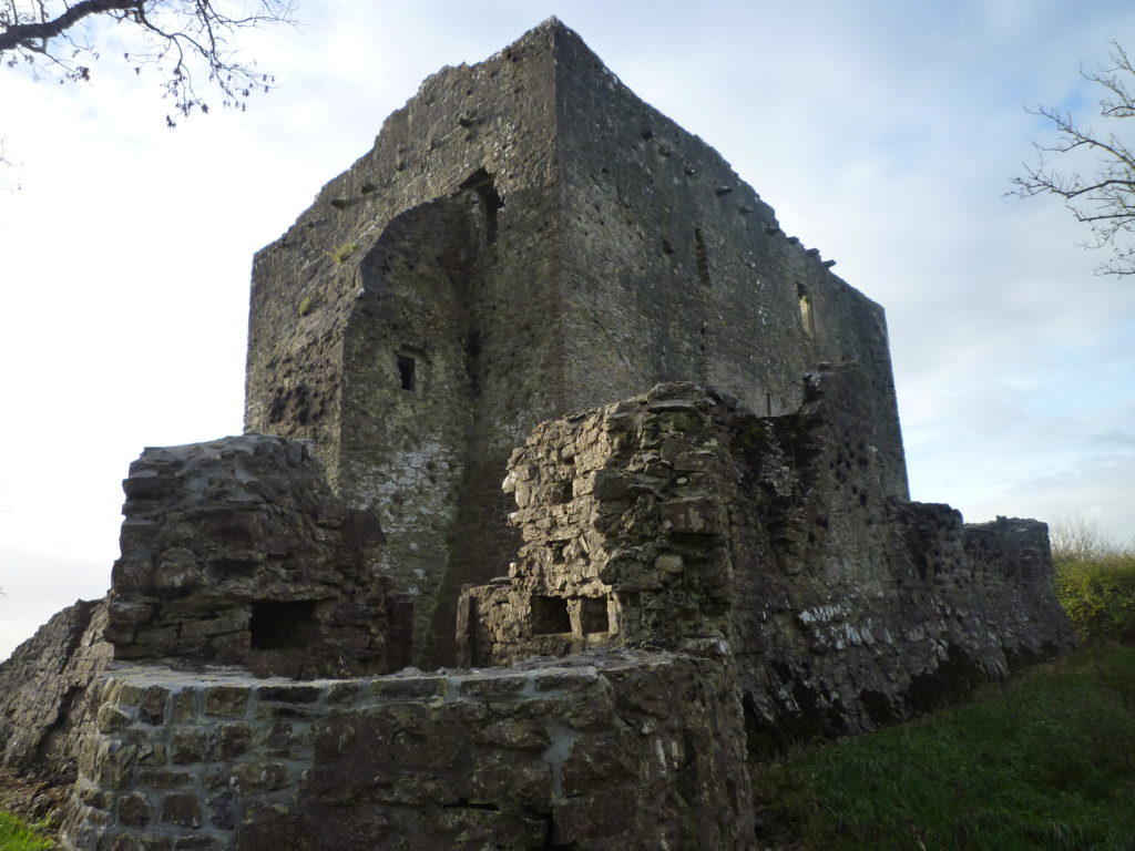
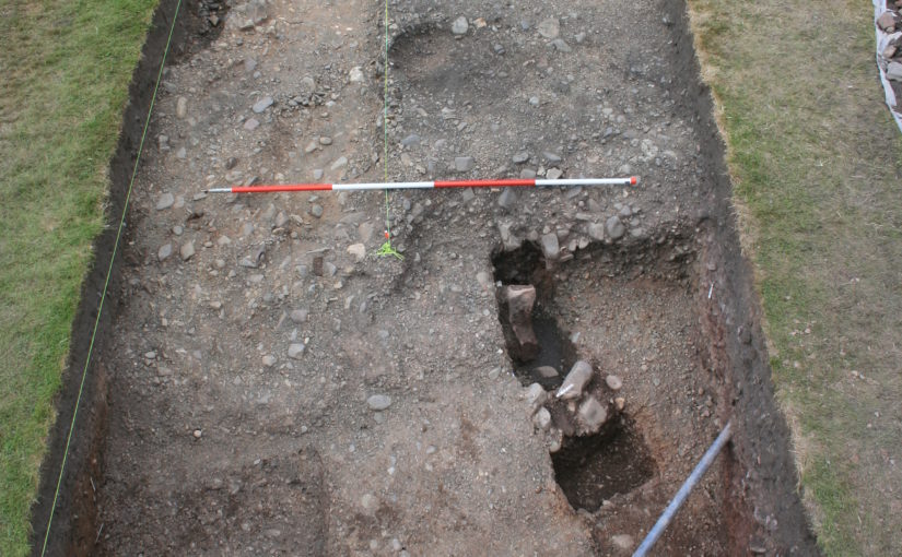
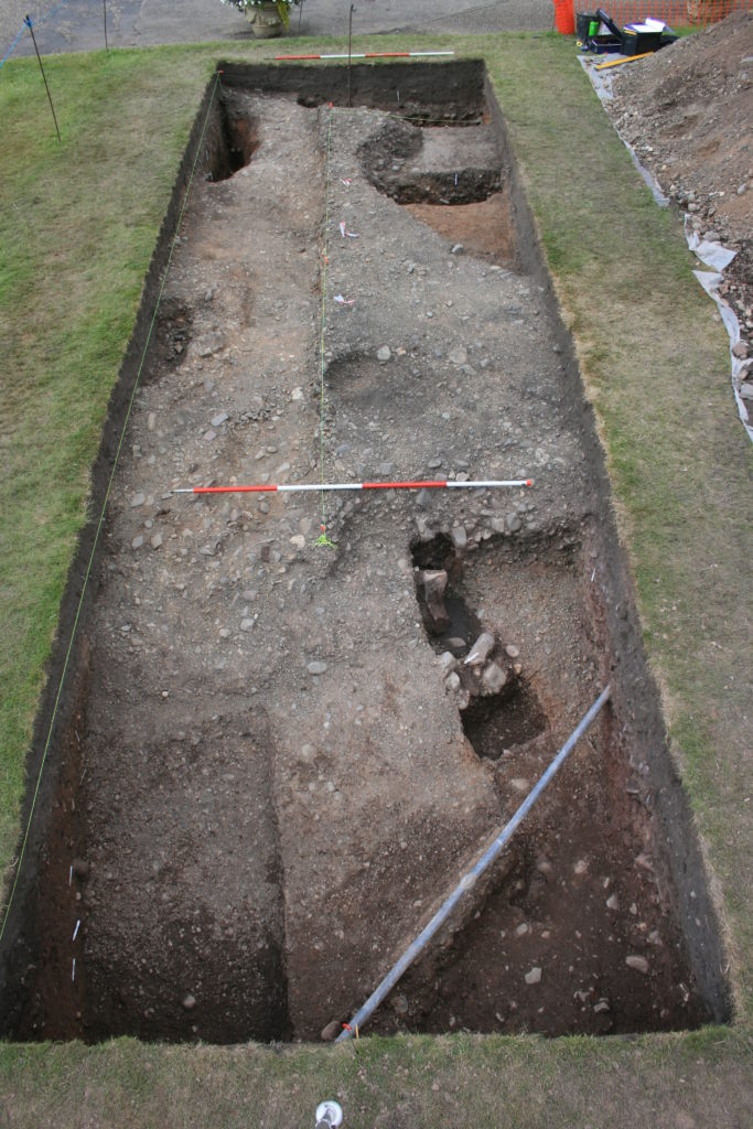
The final season of excavations took place in 2022 on the top of the motte, and outside the north curtain wall. Telford is known to have demolished ruined medieval buildings on the top of the motte and replaced them with the surviving two-storey Gothic summerhouse there. Excavation showed that Telford’s activities had, again, removed most of the archaeology but that the foundations of early medieval timber buildings (beam slots, a post pad, post holes) survived where they had been cut into the motte material. No definite trace was seen of the ‘great wooden tower’ which is documented on the motte top until its collapse in 1269-71.

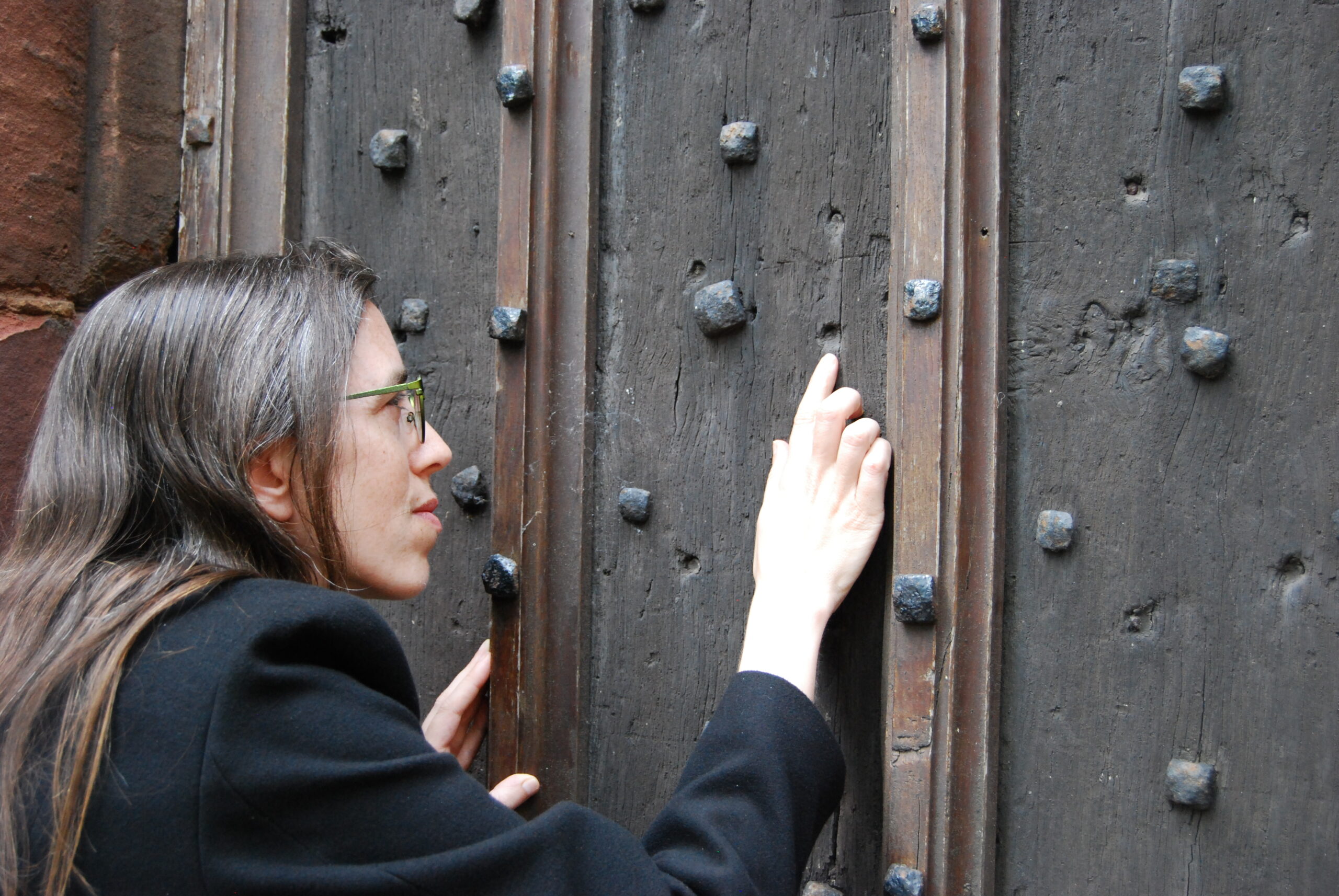
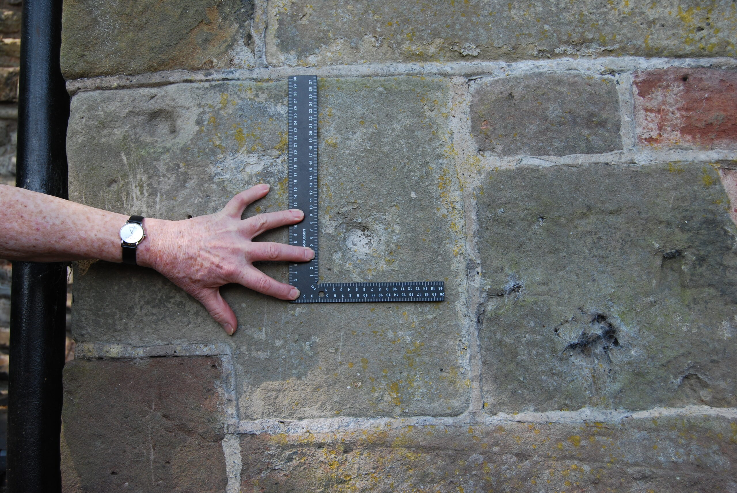
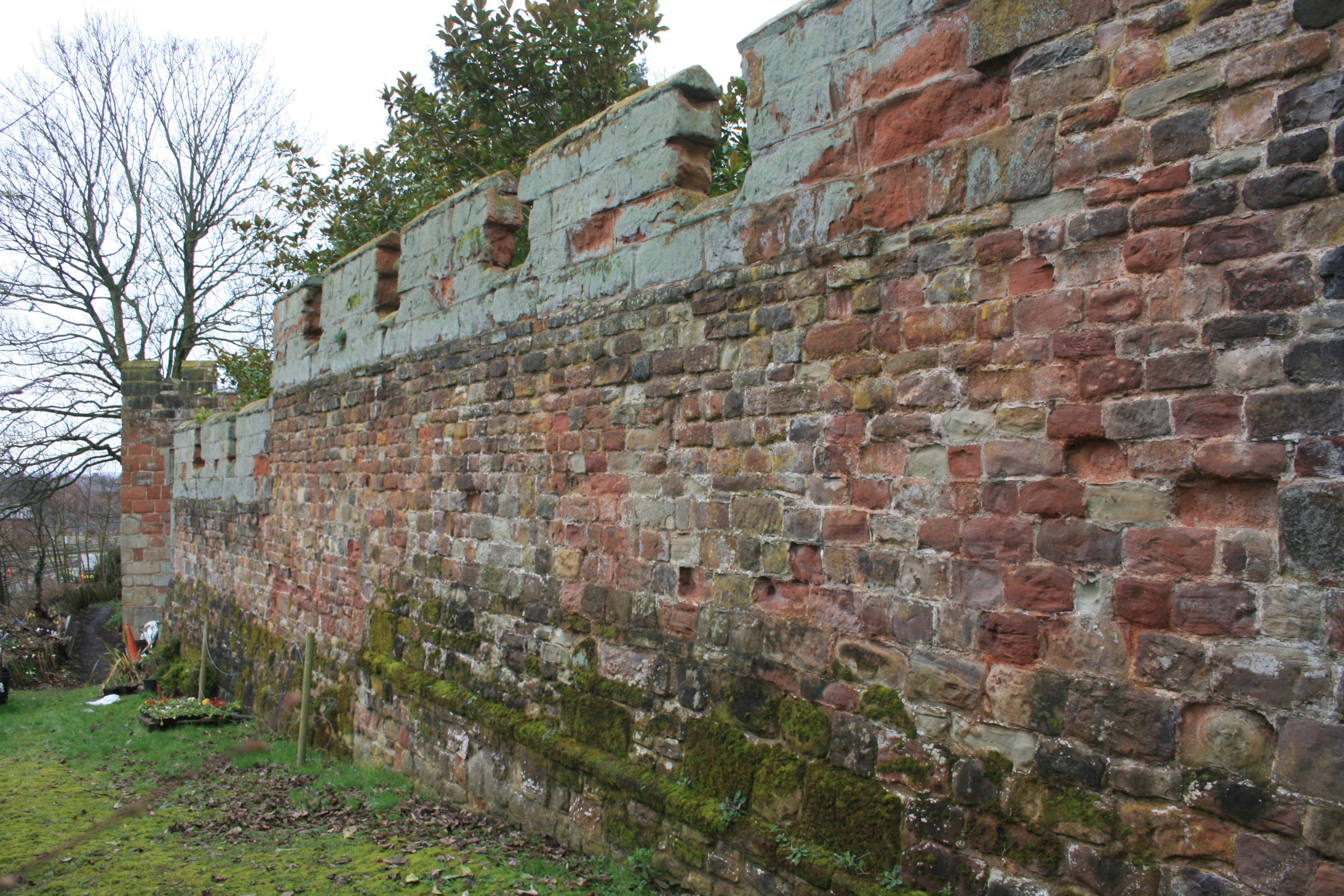
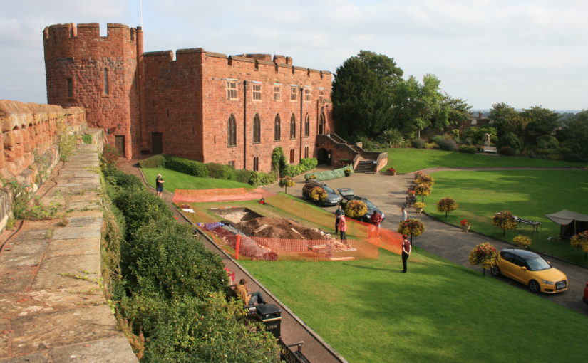
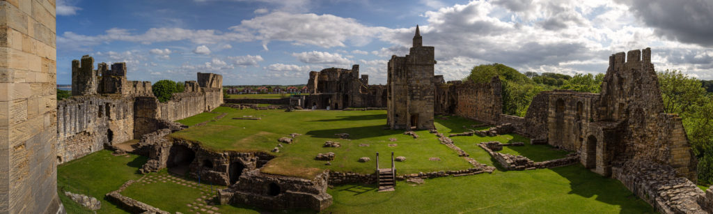
New light was also shed on the motte by vegetation clearance on its south side, revealing for the first time remains of buildings incorporated in the masonry of the retaining walls. This work was undertaken on behalf of Shropshire Council for a new conservation-management plan, currently at consultation stage, which includes photogrammetric surveying of all the castle structures. This permanent stone-by-stone record not only forms the basis for the next vital stage of work – identifying and specifying long-needed repairs – it also offers new archaeological insights, including the identification of the probable primary sandstone rubble fabric of the curtain walls. This was in turn followed by some research carried out by Jason Hurst on Civil War musketry damage in 2023 (Potential shot damage at Shrewsbury Castle – Castle Studies Trust Blog) . And now, the process of publishing this body of new archaeological, architectural and historical information is just beginning…

Subscribe to our quarterly newsletter

Potential shot damage at Shrewsbury Castle

Jason Hurst from the University of Leicester’s School of Ancient History and Archaeology and expert on civil war damage to castles looks at the damage at Shrewsbury Castle.

In June this year I went with Dr Nigel Baker, and Dr Morn Capper of University Centre Shrewsbury, to examine suspected musket/weapon projectile damage inflicted on the Castle, possibly during the Parliamentarian assault of February 1645.

Subscribe to our quarterly newsletter

Dr Morn Capper showing the damage to Shrewsbury Castle’s main gate

When inspecting the marks on the main castle gate I concluded that these were from musket/pistol ball strikes with some indication of possible fragments of these projectiles still embedded in the woodwork, along with possible residues.

Shrewsbury Castle Postern Gate Gun Shot Damage

On the outside of the Postern Gate the identification of some of the marks could not be positively made because of weathering, but intriguing larger impact marks seem to be from a small calibre artillery piece, possible a Robinet or similar sized calibre gun.

At the north end of the hall, facing the railway station, are marks that look like weapon projectile strikes but their trajectory is problematic. Some appear to have come in at a level trajectory towards the wall and some from a downward trajectory, so these need to be looked at in more detail to determine what has caused them.

Subscribe to our quarterly newsletter

What is on top of Shrewsbury’s Motte?

Dr Nigel Baker, Excavation Director of the Shrewsbury Castle Excavation 2022 outlines what he hopes him and his team hope to find over the next two weeks with the main focus on the previously unexplored motte.

A third season of excavation funded by the Castle Studies Trust is about to begin at Shrewsbury Castle. In 2019 a trench was excavated across the interior of the inner bailey and in 2020 an inner bailey rampart was sampled. Attention has now turned to the top of the motte, and to the north curtain wall. The excavations, the first ever to take place at the castle are carried out by a team of local archaeological volunteers under the direction of Dr Nigel Baker and David (Dai) Williams together with students of University Centre Shrewsbury (University of Chester) led by Dr Morn Capper.

Subscribe to our quarterly newsletter

The motte top excavation will establish just how much damage Thomas Telford did to the medieval motte when he was modernising the hall and landscaping the castle in 1786-1790. Ruins on the motte top were cleared to make way for a Gothic summerhouse known as Laura’s Tower, with a garden laid out around it. The team will be looking in particular for surviving evidence of the Tower of Shrewsbury, the timber watch-tower, assumed to be of 11th-century origin, that is known to have collapsed in 1269-71.

Vertical view of Shrewsbury Castle Motte (copyright James Brennan Associates)

The irregular plan of the motte top seen in the drone photo (undertaken by James Brennan Associates for the current conservation management plan for Shropshire Council, the site owner) arises from a number of factors. Originally probably oval, the straight line across the bottom of the picture is a pale sandstone wall with red sandstone stripes built, probably by Edward I’s masons, across the damaged side of the motte after a landslip into the river below in the 13th century. Laura’s Tower occupies the bottom left corner, set off-centre on the base of a 13th-century tower demolished by Telford. The lobed shape of the motte on the left of the photo results from at least two phases of medieval building incorporated in the retaining walls: an angled structure with a high chamfered plinth and recessed masonry panels, superimposed over a projecting curving rubble footing. These remains were seen and recorded for the first time this year as part of the ongoing CMP work.

A second trench is to be opened on the north curtain wall. A long stretch of this wall is unusually consistent in its fabric, with small, squared rubble and two offset courses. 18th-century illustrations show however that a projecting bastion formerly stood in this area, of which no trace can be seen in the standing masonry. The suspicion is that a major part of the wall here has been rebuilt, and the trench is designed to explore this question – and to establish the nature of the surrounding stratigraphy.

Part of the north curtain wall of Shrewsbury Castle. The even coursing apparent over this long stretch of masonry is at odds with the complex fabric visible elsewhere in the wall and with 18th and early 19th-century illustrations showing a projecting bastion in this area. Excavation will seek to confirm whether or not this stretch has been rebuilt, and to locate in plan the features seen in the illustrations. Copyright Nigel Baker

In addition to an introductory display to be mounted in the on-site marquee, there will be two further displays in the town running concurrently with the excavations. In Shrewsbury Museum & Art Gallery in the Square, Dr Capper’s team is assembling a display featuring artefacts found in the first two seasons, while in Castle Gates Library (the former Grammar School buildings) a display is in place that explores the evidence for the former castle outer bailey, within whose perimeter the library stands.

The excavations run from July 18th to 28th. Visitors are welcome every day except those when the castle is closed (Thursday 21st and Thursday 28th).

Subscribe to our quarterly newsletter

Castle Studies Trust is going on its travels in 2022

In its latest round of grants the Castle Studies Trust has awarded £34,000 to five projects including two projects outside the UK. As well as covering a wide geographic area the projects will also undertake a broad range of technics to boost our understanding of castles.

Subscribe to our quarterly newsletter

Dating medieval towers in the hinterland of Medieval Chalkida, Greece:

Stand-alone medieval towers, often part of castles or larger fortifications, are common in Central Greece. Often thought to have been built by the Frankish nobility during their period of dominance between 1204-1470, there is minimal evidence to back this up. By taking wood and mortar samples, the project aims to answer that question.

The present project forms part of the five-year survey ‘Beyond Chalkida: Landscape and Socio-Economic Transformations of its Hinterland from Byzantine to Ottoman times’ (authorised in July 2021 by the Greek State)

Samples will be taken from six towers of wood used laterally within tower walls to increase their structural strength, and mortar from within the core of the walls (both therefore probably

contemporaneous to the original period of construction). Specialists will use dendrochronological and

Carbon 14 methodology for the wood (8 samples), and optical microscopy, Scanning Electron Microscopy (SEM), and X-ray fluorescence (XRF) and diffraction (XRD) Spectroscopy (mortar – 21 samples).

Work will start at the earliest in late 2022 and may not actually take place until next year due to the time it is likely to take to get official permission from the government. 

Kilmacahill, Co. Westmeath

Geophysical survey of deserted medieval settlement close to Jamestown motte & bailey castle. The aim is to understand the morphology of settlement and its relationship with the castle and medieval monastery.

This survey will contribute to a larger project: the Human-Environmental Exchanges in the Landscapes of Medieval Ireland Project (HELM Project) which aims to use a combination of multispectral imaging, UAV drone survey along with geophysical survey to gain a much better understanding of the form of the deserted medieval village through non-invasive methods.

At time of writing it was unclear when the survey will take place.

Pontefract, West Yorkshire

Pontefract Castle: Service area between the kitchen and royal appartments copyright Angela Routledge, Wakefield Council

The project funded will be a geophysical survey of two parts of the castle, which during its history was the main royal castle in Northern England, not previously investigated. The survey will be of two areas of the castle using Magnetometry, Resistivity and Ground Penetrating Radar (GPR)

The focus is on parts of the castle not previously explored by  excavations in the 1980s, especially around the northern ramparts. This area stretches from the Swillington Tower towards the Kings Tower, and includes several earthwork features which remain unidentified, or unconfirmed.  Geophysical investigation is likely to reveal several interesting features including the link wall between the curtain wall and the Swillington Tower, which is unique in that it was built outside the main castle defences.

A second area that we have very little information on is part of the castle known as the “service buildings”. This area has never been excavated and we have very little knowledge regarding the layout or function of this part of the castle. 

As yet it is unclear when the survey will be undertaken.

Raby, Co Durham:

Aerial View of Raby Castle copyright Raby Castle

The Trust will be co-funding the project which aims to improve the understanding of the castle in the medieval period, especially around 1400 in the decades immediately after the licence to crenellate, with a buildings survey and development of a 3D model.

Once a stronghold of the Neville family, it moved into the ownership of the Vane family in 1626 and has been much altered and modernised, especially in the Victorian period, into a palatial family home.  Large sections of the medieval castle survive intact, albeit intersected and extended with more recent architectural additions.

This project seeks to strip back the more recent layers, to make sense of the medieval castle. Our aim is to create a 3D visualisation of Raby Castle in around AD 1400, helping us to visualise and to understand (where possible) how it functioned before the later additions.

In addition to boosting our understanding of the castle, the plan is also to train up a team of volunteers in how to carry out a building survey.

The aim is to start the survey work in April. 

Shrewsbury, Shropshire:

Shrewsbury Motte Top copyright Nigel Baker

This is the third project the Trust has funded on this important castle of the Welsh Marches and is an excavation of the motte top. The first two excavations in the inner bailey discovered that the original inner bailey was a lot smaller than it is today with little room for any substantial buildings, especially the royal hall.

This leaves only the motte and the aim is to understand the structural sequence and assess the character and the status of the buildings there: specifically to identify the royal hall known to be present during the Middle Ages.

The excavation is due to take place in the second half of July.

Subscribe to our quarterly newsletter

Featured image Shrewsbury Castle by air courtesy of Shropshire Council

Recent discoveries at Shrewsbury Castle

With the 2020 excavation report now published, Shrewsbury Castle Excavation Director Dr Nigel Baker looks back at the two years of excavations and what they reveal about this important castle of the Welsh Marches.

Before the excavations in 2019 and 2020 funded by the Castle Studies Trust, Shrewsbury Castle was one of the least well understood major castles of the Welsh Marches. Its visible form is that of a classic motte-and-bailey, with earthen ramparts surmounted by stone curtain walls. However, the archaeological project and associated research has shown that the historical reality is more complex than this.

Subscribe to our quarterly newsletter

First recorded as a consequence of being besieged by local rebels in 1069, many aspects of its recorded history follow a familiar Marches pattern: heavy royal expenditure in the 12th and 13th centuries as a campaign base and in the face of Welsh raiding, followed by decline into obsolescence and ruination in the 14th, 15th and 16th centuries, arrested temporarily by a return to active service in the English Civil War in the 1640s. Its later history was as a private residence, distinguished by its ‘restoration’ by Thomas Telford in 1786-1790, and finally its return to public life as a council meeting hall in 1925 and as the home of a regimental museum in the 1980s.

First of all, the Norman castle was not built on an empty site. It occupied the end of a ridge that was critical to the defence of the old Saxon borough, and the 2019 excavation demonstrated occupation here in the 10th or early 11th century, on a plateau or low knoll at about 68m AOD, higher than its surroundings, and at one end of the likely cross-peninsula borough defences. At present the archaeological evidence is limited to a single pit and its artefacts, but reading between the lines of the historical record, it is possible that the site was shared by a church dedicated to St Michael and perhaps a hall, maybe that of the pre-Conquest sheriffs.

Plan of Shewsbury Castle as it may have appeared in late 11th / early 12th century copyright Dr Nigel Baker. The black lines indicates probable masonry curtain wall lines, based on the presence of the ‘green slabby rubble’ masonry that appears at various junctures at the bottom of some elevations and seems to be early, meaning potentially pre-13th

The Norman castle of the 1060s wiped out all that had been there before, except the church, which appears in Domesday Book; this also records the loss of 51 tax-paying households when the castle was built. It consisted of a large motte overlooking the river, elevated to a height (80m AOD) equal to that of the royal and episcopal halls within the old borough, with a substantial ditch, discovered in 2019, around its base. West of the motte was a small inner bailey. Extending south was a much larger outer bailey, separated from the English borough further south by a second cross-peninsula ditch and supplemented in the 12th century by earth ramparts around the bailey perimeter. The small size of the inner bailey, in reality perhaps more of a barbican, suggests that the royal hall, documented from 1246 but probably present from the beginning, was on the motte top.

It is not yet clear when the earth and timber defences began to be replaced in stone, but stretches of thin, slabby rubble in the curtain walls and motte wing walls may be indicative of work in the late 12th or early 13th century.

Major changes took place throughout the 13th century, some documented, some suggested by the excavations. The single surviving medieval building, often called the hall, is fairly certainly the camera regis or royal chamber built in 1239-41, a date consistent with the dendrochronological evidence from the building. It may have been constructed as part of a larger rebuilding campaign that saw the west side of the inner bailey expanded westwards by pushing a terrace out over the gradient behind a newly-built ashlar curtain wall. This is one of the conclusions of the 2020 excavation trench through the western rampart, which found medieval tipped strata at a level below that of the natural gravel seen in the interior of the bailey in 2019.

Plan of Shrewsbury Castle in late C13. Copyright Dr Nigel Baker

Meanwhile, the east side of the motte was subject to erosion by the River Severn and the consequent partial collapse of the motte was recorded by an enquiry held in 1255; in 1269-71 a ‘great wooden tower’ fell down and was said to be totally destroyed. The motte top was repaired towards the end of the 13th century with a new wall built across the damaged side in red and white striped masonry. The motte ditch appears to have been infilled, mainly by the deposition of rubbish, and a new castle well, which survives, was dug within it.

As the town grew, the outer bailey was built over. In 1220-c.1250 when the town walls were built, the outer bailey was walled continuously with the rest of the town and no longer separated from it; the tenements that had been established there continued to pay their ground rents to the crown while those outside, further south, paid theirs to the borough.

Two early plans show what had become of the castle by the end of the 16th century. The Burghley Map of Shrewsbury of c.1575 shows the main building unroofed, a smaller building (perhaps St Michael’s) in ruins, and just one roofed building standing in the inner bailey in the area of the surviving well. A sketch plan by the master mason John Smythson of 1627 likewise shows the main building, and most of the curtain walls, in a ruined condition; it also shows a gatehouse of which there is no other evidence.

Restoration came in 1643-44 when the castle was garrisoned by the Royalists, and the borough’s mayoral accounts record expenditure on the main gate and its new barbican, a new postern gate, walls and outworks. The castle was captured for Parliament in February 1645; what appears to be battle-damage can be seen on the woodwork of the main gate and around the openings of the main building but this identification now needs confirmation by battlefield archaeologists. After its capture, the Parliamentarians continued the Royalists’ restoration of the main building, its roof and gallery built with timber felled in the winter of 1647. The castle was finally de-munitioned in 1686 and became a private residence.

Shrewsbury Castle in 18th Century, note on the wall on top of the motte the possible base of windows of a high status building / Great Hall.

Thomas Telford’s ‘restoration’ of the castle in 1786-1790 for Sir William Pulteney was nothing if not brutal. The excavations in the inner bailey have shown that the interior was levelled down, scraped bare, and at least some of the material used to enhance or even create the ‘ramparts’ around the perimeter. Illustrations show that, until 1786, the motte top was still occupied by a 13th-century round tower and the ruins of other, as yet unidentified, buildings. These were all swept away and replaced by Telford’s ‘Laura’s Tower’, a fine, two-storey summerhouse in the Gothick style.

Subscribe to our quarterly newsletter

Shrewsbury Castle – more than meets the eye

Shrewsbury Castle Excavation Director, Dr Nigel Baker, reviews the second season of excavations at the castle which has just ended, with an unexpected conclusion.

Shrewsbury Castle has sometimes been described (most often by the writer of this blog!) as one of the best-preserved shire town motte-and-bailey castles in the west of England. This remains true – at least in the sense that it has never been quarried away for gravel, nor had a prison or law courts built on top of it, nor was it demolished and redeveloped after the Civil War. Nevertheless, such a statement now requires a hefty footnote.

Subscribe to our quarterly newsletter

A visitor, walking into the inner bailey at the foot of the motte sees crenelated curtain walls rising from the top of substantial ramparts: the impression of a classic castle sequence with earth-and-timber fortifications renewed in stone, is overwhelming. The 2020 work has however shown that neither the ramparts nor the western curtain walls are quite what they seem. Excavation to a depth of more than two metres in the western rampart has shown that at least half of its height was a product of the post-medieval centuries – with a substantial contribution probably made by Thomas Telford during his ‘restoration’ of the castle in 1786-90, enhanced by his simultaneous lowering of the ground level across the interior.

Shrewsbury Castle excavation trench in western rampartas viewed fromfrom C13 logis block. Courtesy of Nigel Baker

But the medieval strata below Telford’s rubble also show that the western curtain wall, and by implication the standing castle building, the camera regis of the later 1230s, can no longer be seen as simple improvements to the original earthwork castle as the ground beneath them was found to drop away sharply, the slope levelled up by a massive medieval earthmoving operation. It seems that the present outline of the castle – and the familiar view of it from the railway station below, are a product of the early 13th century (dating subject to confirmation when the pottery has been analysed) – dubbed Shrewsbury Castle 2 by the excavators. The ‘original’ motte-and-bailey, first heard of when it resisted a siege in 1069, must have had a perimeter that was around 25% smaller, confined to the original hilltop. This castle (inevitably ‘Shrewsbury Castle 1’) was nevertheless heavily fortified, as the substantial motte ditch found in 2019 shows. As originally conceived, the ‘inner bailey’ was little more than a lobe-shaped barbican, protecting access up onto the motte, with little room for buildings within it. One of the implications of this is that the most important buildings – like the royal hall – must have been on the motte top.

The medieval landfill operation is also of interest on account of the rubbish contained in its strata. Preliminary visual identification of the animal bones suggests that game species are present, possibly pike, possibly swan, and it is likely that further work on this material will add to the growing corpus of evidence for high-status diet on castle sites throughout the region.

Subscribe to our quarterly newsletter

The excavation was funded by the Castle Studies Trust and supported by University Centre Shrewsbury under Professor Tim Jenkins and Dr Morn Capper. Archaeological direction was by Dr Nigel Baker and Dai Williams and the work was undertaken by local volunteers and UCS postgraduates and undergraduates.

Feature image courtesy of Dr Nigel Baker

Shrewsbury Castle: a 2020 vision, from Saxon habitation to C18 landscaping?

Project lead for the Shrewsbury Castle excavations Dr Nigel Baker looks forward to the forthcoming excavations at the castle, hopefully this year, funded by the CST

Last year, the Castle Studies Trust excavation – the first ever to have taken place within the walls of Shrewsbury Castle – produced three headline conclusions. The first was that the work of the young Thomas Telford there for his client, William Pountney M.P. in 1786-90 was, sadly, more destructive of the medieval original than had previously been recognised. The extent of his restoration of the house (now the Soldiers of Shropshire Museum) and the curtain walls has long been known. What wasn’t appreciated was that standing walls of ruined buildings and a 13th-century tower on the motte top were destroyed and reduced to their footings, and the interior of the inner bailey was, it seems, scraped flat, producing a lovely level lawn at the expense of any archaeological deposits overlying the natural gravel of the hilltop. Despite this, infilled negative features (pits and ditches) cut into the gravel survived and were found by our excavation trench. As a result, our second headline conclusion was that the motte was ringed on its landward side by a massive ditch, twelve metres wide: what we know as the inner bailey must, in the early Middle Ages, have been little more than a barbican defending the end of the bridge giving access up the motte.

C18 Remodelling?

But the extent of Telford’s work raises a question, first put to the archaeological team by Martin Roseveare, our geophysicist: if Telford had the inner bailey levelled flat, where did he put the proceeds, meaning the scraped-up earth and debris? Could the apparently well-preserved medieval ramparts ringing the bailey actually be down to the young Scottish civil engineer, rather than impressed English labour under the whip-hand of William the Conqueror’s henchmen? This is one of the leading questions that a second season of excavation at Shrewsbury Castle hopes to be able to answer, by digging on part of the western rampart known to be already disturbed by former Victorian greenhouses.

High Status Saxon Living

There are, however, other at least equally compelling reasons for excavating on this site. The third headline conclusion of the 2019 trench was that there was pre-Conquest activity within the area of the inner bailey. This was demonstrated by a pit, pit 20, containing Stafford-type ware (well known in late pre-Conquest Shrewsbury) and a type of pottery known as TF41a, an import up the Severn from Gloucester, never seen before in Shrewsbury. The question is, what was it doing there?

Top piece Rim of type 41a Saxon pottery from Gloucester
Lower piece: Rim of Stafford ware Saxon pottery

Shrewsbury is one of those castles listed in Domesday along with the destruction it caused to its ‘host’ shire town. Construction of Shrewsbury Castle took out 51 tax-paying tenements, a quarter or a fifth of the total built-up area, to the economic distress of the remaining inhabitants. Many of the destroyed plots will have lined the strategically important Chester to Hereford road that passes through the outer bailey. However, looming over the road and its plots, and the main gate through the pre-Conquest defences, was the hilltop on which the castle would come to be built. And on it, overlooking the gate, most likely on the Victorian greenhouse site, was the Church of St Michael, a church that became the castle chapel, but was listed in Domesday between the entries for two of the town’s pre-Conquest minsters and was served by two priests later in the Middle Ages, when it was a royal peculiar, exempt from episcopal oversight. This need not necessarily all add up to a pre-Conquest church – but the chances are very strong that it does, and that this church, which, overlooking the town defences,  may have had some kind of defensive role, was part of the context of pit 20.

Subscribe to our quarterly newsletter

The clues are beginning to point to a high-status site, probably enclosed, with its interior ground level two metres above that of its neighbours, and its own church. For an analogy, one could do worse than look to Wallingford, whose castle in the north-east corner of the Saxon burh had probably taken over and re-fortified a royal site of some kind, possibly housing government functions, perhaps a mint, and a garrison of housecarls. Or one might look to Oxford, where St George’s Tower is now generally thought to be of pre-Conquest date. Shrewsbury seems to be joining the list of Norman town castles established on sites of political, not just tactical, importance.

But archaeology can be frustrating. While we hope that excavation of the Victorian greenhouse site in the west rampart may yield insights into the extent of Thomas Telford’s landscape gardening, the foundations of a pre-Conquest church and further clues to a high-status or even royal site preceding the castle, by 2021 the excavation team may well be singularly well-informed experts on…Victorian greenhouses.

Subscribe to our quarterly newsletter

Our five projects for 2020

The results are in, we’ve decided which projects we will be funding for 2020.

But before we get to the announcement, we want to thank all the applicants who proposed projects. It was a difficult decision, with exciting and innovative approaches to a group of fascinating castles. This year marks a milestone for us: we are award £30,000 across the successful projects which is the most we’ve given in a single year.

So without further ado, here are the five projects we will be funding in 2020. We hope you are looking forward to discovering more about them.

Lincoln Castle

Photo by Gustavo Faraon, licensed CC-BY-NC 2.0

The project will develop a reconstruction drawing of the castle, as it would have been in the latter part of the 12th century, founded by William the Conqueror, in the second half of the 11th century.

Shrewsbury Castle

We will be funding a second year of excavation, following on from 2019, this time to understand the rampart of the inner bailey.

Sowing the Seeds

Castlecarra is one of the sites to be investigated. Photo by Karen Dempsey.

The aim of the project is to try and understand better everyday life in castles by seeing if there are any surviving plants at four Irish castles that were planted, grown, and cared for by medieval people.

The Wirk

Could the Wirk be a Norse castle? Based on the island of Rousay, this stone tower is situated close to the old parish church and recently discovered Norse Hall. However, no one knows what this tower was used for or even when it was built.

Warkworth

 Photo by Karl Davison, licensed CC-BY-NC 2.0

Using various forms of geophysical survey to try and understand the subsurface features for the former caput of the Earls of Northumberland.

Donate regularly for invitation to exclusive site visits

Regular donors will be invited to all exclusive visits to the projects we fund.

Those who are able to donate £500 a year or more (excluding Gift Aid) will also have the opportunity to attend our annual special castle visit to major/privately owned castles. In 2020 this will be at Edinburgh Castle on Saturday 6 June where we will visit parts of the castle not open to the public.

Any new donations by standing order or payroll giving will be matched by a generous supporter for the next two years up to a maximum of £2,000 a year in total.

You can donate regularly via payroll giving or by setting up a standing order. Please return the form to the address on the forms, with the gift aid form if applicable.

A Large and Eclectic Crop of Fascinating Applications for the Castle Studies Trust to Consider

The deadline for grant applications passed on 30th November. We’re going through the various projects now. Altogether the 13 projects, coming from England, Ireland, and Scotland are asking for over £88,000. They cover not only a wide period of history but also a wide range of topics. In a little more detail, here are the applications we’ve received:

Bamburgh, Northumberland

Photo by Thomas Quine, licensed CC BY 2.0.

The main aim is to recover evidence for the base natural topography around the approach to the main gate of the once royal castle, from the area of the medieval village, and explore how this was altered, presented and exploited to create a sense of theatre for visitors to the site.

Berkhamsted, Hertfordshire

Photo by Sean Wallis, licensed CC BY NC 2.0.

A geoarchaeological auger survey of the moats that surround this former royal castle and palace of Thomas Becket. The survey aims to answer such questions as what were the moats original profiles, when were the moats filled and how do the two moats compare with each other.

Dunollie, Argyll

Photo by Paul Lloyd, licensed CC BY NC SA 2.0.

To try and understand the date of the construction of the castle owned by the MacDougall clan through various through buildings and materials analysis including radiocarbon dating and mortar analysis.

Fraoch Eilean, Loch Awe

Photo by Andrea Hope, licensed CC BY SA 2.0.

To try and understand the date of the construction of the former royal castle through various through buildings and materials analysis including radiocarbon dating and mortar analysis.

Hoghton, Lancashire

The aim of the project to continue the work the CST funded in 2019 with excavations and building survey. Further excavations will try and understand the purpose of the structures found in the 2019 excavation season and if they were related to the original great tower.

Holme Pierpont, Nottinghamshire

To build up an understanding of this late medieval great house, never previously researched. The work will include a mixture of desk research, building survey and geophysical survey of the parkland surrounding it. The house is the most complete of the three late medieval brick-built houses in Nottinghamshire.

Lincoln, Lincolnshire

Photo by Ben Keating, licensed CCY BY NC SA 2.0.

To develop a reconstruction drawing of the castle as it would have appeared in the second half of the 12th century. Lincoln Castle was founded by William the Conqueror in the late 11th century.

Shrewsbury, Shropshire

To fund a second year of excavation, this time to understand the rampart of the inner bailey. The geophysical survey carried out in the 2019 suggested there could be remains of buildings there, possibly even a late Saxon church. Shrewsbury was a very important border castle up until the 13th century and frequently used as a base for English raids into Wales.

Sowing the Seeds

Hortus conclusus depicted by Meister des Frankfurter Paradiesgärtleins

The aim of the project is to try and understand better everyday life in castles by seeing if there are any surviving plants at four Irish castles that were planted, grown and cared for by medieval people. The research will involve ecological surveys at each location.

Strongholds of Wessex

Photo of Silbury Hill by Greg O’Beirne, licensed CC BY SA 3.0.

The aim of the project is to understand the military organisation of the northern part of Wessex (Wiltshire and West Oxfordshire) from the transition from Saxon to Norman rule between the 9th and 12th centuries. The work will involve documentary research, landscape and place name surveys. Sites examined will include Castle Combe, Cricklade and Silbury Hill.

The Wirk, Orkney

Rousay - The Wirk

Could the Wirk be a Norse castle? Based on the island of Rousay, this stone tower is situated close to the old parish church and recently discovered Norse Hall. However, no one knows what this tower was used for or even when it was built. The work would involve a geophysical survey of the surrounding area as well as two trial trenches to try and find dating evidence.

Thermal Imaging of Castles

A thermogram of Cirencester Roman amphitheatre by Dr John Wells, licensed CC BY SA 4.0.

To test how useful thermal imaging could be in understanding castles. The thermal survey using a FLIR camera of two castle facades in different climates. within the UK—Caisteal Uisdein, on the coast of Loch Snizort, and a castle farther south and slightly inland, Castle Rising.

Warkworth, Northumberland

Photo by Barry Marsh, in the public domain

Using various forms of geophysical survey to try and understand the subsurface features for the former caput of the Dukes of Northumberland. The survey will focus on the bailey inside the 12th-century curtain wall as well as the strip of land outside but on the early earthwork castle, the motte and field near the entrance to the castle.


The applications have been sent to our expert assessors who will go over them. And if you want to know more about how the assessment process works, we have a brief summary.

The Shrewsbury Castle excavation: end of dig report

The investigations funded by the Castle Studies Trust at Shrewsbury Castle, one of the most important castles along the Anglo-Welsh border have now finished. Dr Nigel Baker reveals the preliminary findings of those investigations.

Before the dig began two weeks ago, our geophysics survey showed (with complete accuracy as it turned out) a spread of hard material just under the grass directly opposite the castle hall – possibly the remains of demolished buildings. Almost immediately the turf was off it became apparent that the hard material was not rubble but a low ridge of gravel, curving slightly as it headed south towards the main gate. Cut into this road surface (as we took it to be) were round, flat-bottomed topsoil-filled cuts, probably Victorian and later flower beds.

Subscribe to our quarterly newsletter

Excavating through the gravel immediately revealed further, cleaner gravel, that appeared to be of natural/geological origin; further testing demonstrated that all the gravel was natural – the natural/geological top of the hill. It had been levelled, planed-off horizontally, in the fairly recent past, possibly in 1925-6 when the castle was restored, and any archaeological layers or building remains above the gravel would have been removed.

However, at the east end of the trench the gravel was found dug away at a 45-degree angle by a single, massive cut, with medieval pottery in the soil within it. The cut was recognised as the edge of the great defensive ditch that formerly encircled the base of the Norman motte. This would have been about 12 metres wide; the geophysics suggests there was probably a bridge over it, just north of the excavation, opposite the present hall entrance. The objects found in the ditch include pottery – cooking pots and glazed jugs – from the period roughly 1100-1400, and a large quantity of animal bone from food waste. There were also two arrow heads or crossbow-bolt heads, both of the ‘bodkin’ type: sharp, square-edged heavy points designed to penetrate armour and clearly for military use rather than hunting.

The principal conclusion of the excavation was that, when the castle was first built by the Normans in or just before 1069, the motte, with its defensive ditch, was enormous, and the inner bailey was tiny – it was little more than an extra layer of fortification wrapped around the approach up to the motte.

Subscribe to our quarterly newsletter