What did the Castle Studies Trust funded research at Bamburgh find?

Jo Kirton and Graeme Young, co-director of the Bamburgh Research Project (BRP) outlines what happened during their 2023 season and what the CST funded part of the research at this iconic castle revealed.

Throughout July 2023 BRP staff ran our annual field school at Bamburgh Castle, which is currently exploring the medieval outworks at the northern tip of the castle. We also welcomed several experts to site, funded by our CST grant, to undertake complementary survey alongside our excavation.

Subscribe to our quarterly newsletter

Historic Building Consultant Peter Ryder joined us to undertake a preliminary masonry survey of the extant outworks while Tony Liddel from Vindomora Solutions created several 3D models of the standing outworks and internal structures of Elmund’s Tower and our associated trenches. Dr Kristian Strutt and his team from the University of Southampton undertook a geophysical survey of the castle ditch and explored how this interacts with the outworks, as well as identifying related features and access ways to St Oswald’s Gate. BRP staff and students worked with the team, trying their hand at GPR, resistivity and magnetometry.

The reports from the masonry and geophysical survey, plus the associated3D models have now been completed and incorporated into the BRP’s Interim Report on Work on the Outworks Beyond St Oswald’s Gate. This is a summary.

Background

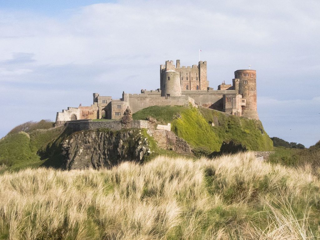
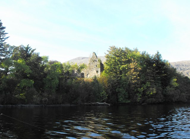
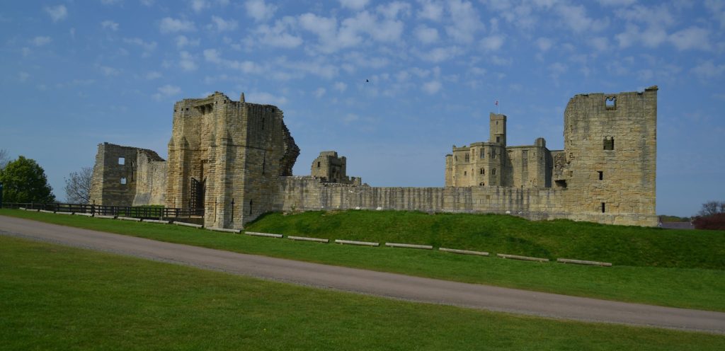
The Bamburgh Research Project (BRP) was set up in 1996-97 to undertake archaeological investigation of Bamburgh Castle and its environs. The area immediately within St Oswald’s Gate was investigated in an effort to identify early elements of the fortification and structures associated with the entrance; documentary evidence indicates that this gate was the principal, and perhaps only, entrance to the fortress in the 8th century AD and likely remained such until the main gate was relocated to its present position in the 12th century.

The rock outcrop on which Bamburgh Castle stands is comprised of volcanic dolerite that rises some 30m above the external ground surface. The surface of the plateau is c.3 hectares in area. It undulates in height, sloping downwards from the Inner Ward area at the south-east, which reaches 45m OD, to the north-west end of the West Ward where St Oswald’s Gate lies. Here a natural cleft in the bedrock on the landward side leads out and down the slope of the plateau. This has formed a natural route up to the summit from earliest times bridging, if awkwardly, the height difference between the West Ward at some 22m above sea level and the surrounding ground surface that lay at 13m OD. St Oswald’s Gate is written about as the entrance to the fortress of Bamburgh in the 8th century AD (Symeon HK, III. pg 37) and was very likely the earliest route up onto the rock plateau.

Subscribe to our quarterly newsletter

Current work

The present phase of work began in the summer of 2021. We are investigating the entrance, the access routes up to the entrance and the structures and outworks built to control this route over many generations. One area of focus was the recovery of the site of the Tower of Elmund’s Well, named in records from the 13th century (Colvin, H. M. 1973, 556) and onto which a cottage was constructed in the late 18th century.

The plan outline of the cottage/tower structure was quickly revealed during the first phase of investigation by the removal of foliage and a modest volume of aeolian sand. One of the first exciting discoveries during the 2022 excavation was the presence of two splayed lights (open window-like features) in two of the walls.

Figure 1: Aerial photo of the outworks with the cottage/tower seen in the top right corner. The steps that lead back to St Oswald’s Gate, through the Wing Wall, at the bottom of the photo. Facing west. Copyright Bamburgh Research Project

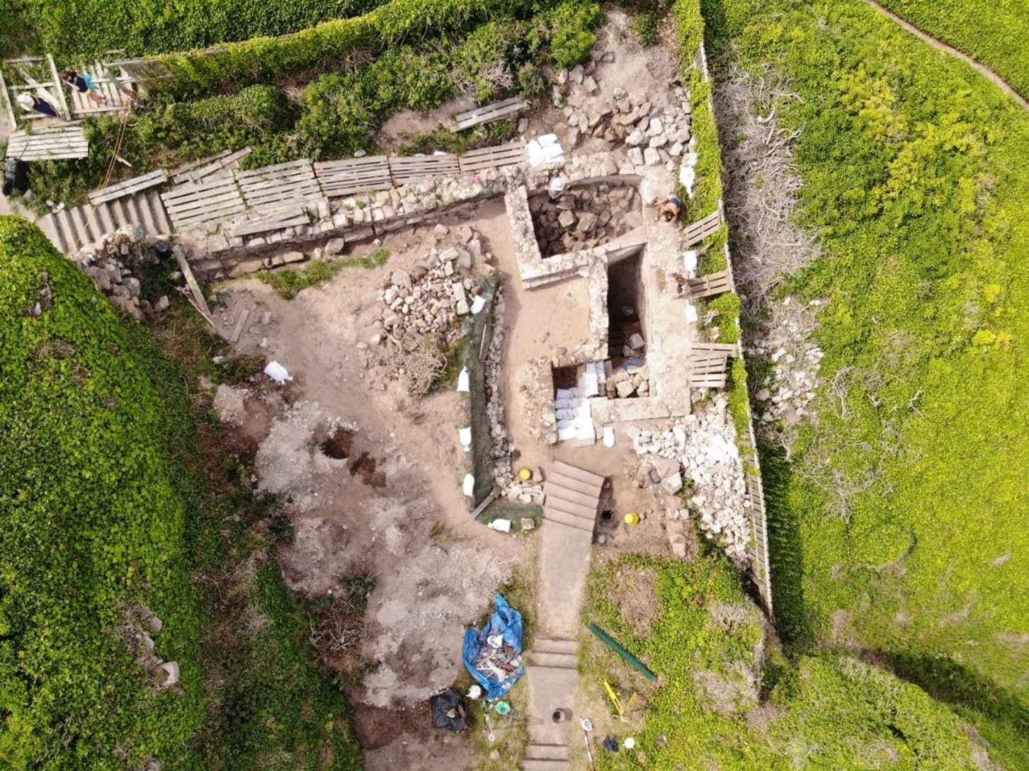
The elements of the cottage are now exposed fully in plan and when interpreted alongside the available cartographic evidence would suggest that the entrance was re-aligned due to the build-up of sand deposits in the area that have been slowly burying the standing structures during the post-medieval period. Two short flights of more recent stairs, each turning through a right angle, lead to a long straight set of stairs of older character and showing substantial wear, that extended down through the arch to the basement of the tower where we know from cartographic evidence the well was once present, in what is now a basement room. Here excavation must be getting close to the floor level and some four phases of build are seen in the exposed walls that now reach almost two storeys. The lower two of these phases are likely to be elements of the medieval tower and the upper, by default, phases of the cottage that was built on and into the tower from the 18th century.

There was further work on the postern gate that lies beyond St Oswald’s Gate that leads out to the village which had been subject to limited survey and excavation in previous seasons. Continued excavation immediately behind the wall that leads back to the castle rock has uncovered more of the structure. We intended to uncover more of the wall, recover some datable finds and identify the level from which it was constructed. The structure as uncovered is a single well-constructed feature of coursed squared masonry that ended abruptly and deliberately short of the rock. A further constructed face abutted the bedrock and the gap between the two faces is a little more than 1m wide, forming what must have been a second gate. The eastern of the two is likely the earlier of them and must have led to a timber stair as it is well above ground level. The western, that is currently still in use, may have replaced it as more practical as it is closer to ground level, though still reached by stairs, the current version of which appear to be late post-medieval. This wall extends well to the west where a form of it turns to the north towards the tower/cottage. All the elements that are currently exposed appear to be late in date and the medieval wall must lie beneath the current ground level.

In 2023 we opened Trench 5E, sited outside of the wall with the postern gate and the outworks. It was placed next to a short length of wall that we investigated last season to see if it had once extended further. It has revealed a stone alignment that extends parallel to the two standing walls. Those of the outworks and the short wall length. So far only the upper level has been uncovered, so it is possible that it could be either a wall top or a foundation or the surface of a narrow path.

Work supported by funding from the CST

CST funded BRP to undertake additional non-invasive survey work to offer additional context to the excavation outlined above. Initially, and to better frame the results of the geophysics and limited excavation a walk over study was undertaken by BRP and Peter Ryder. This aimed to provide a description of the standing structures in their historical context, as they are currently understood and was supported by selected areas of photogrammetry survey.

Subscribe to our quarterly newsletter

St Oswald’s Gate itself extends out through the curtain wall to the landward side at the northern end of the castle. It passes through a vaulted tunnel to the gate and appears to represent two phases of medieval build with a third – post-medieval – phase represented by internal and external refacing, likely of the late 18th century.

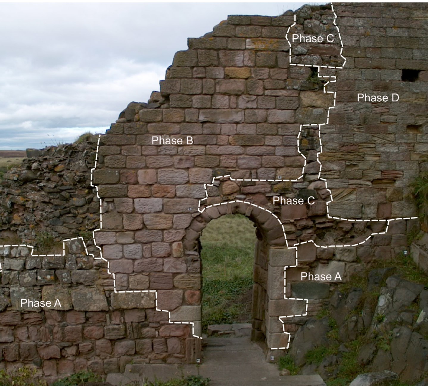
One of the most enigmatic features is the Wing Wall (W2 (see Figure 2) that forms a partial barrier to the route down from the gate. It appears to be one of the older elements of the defences with at least four phases of masonry (see Figure 3) and is relatively narrow compared to the later medieval defensive walls, such as the South Wall (W2) that cuts and post-dates it. It also contains an unusual arched doorway of early form that may be reused from elsewhere.

Figure 2: The northern extent of Bamburgh Castle showing the site of the outworks and the silted tidal port. Copyright Bamburgh Research Project
Figure 3: The narrow ‘Wing Wall’ showing the narrow archway and multiple phases of construction, facing north-west Copyright Bamburgh Research Project

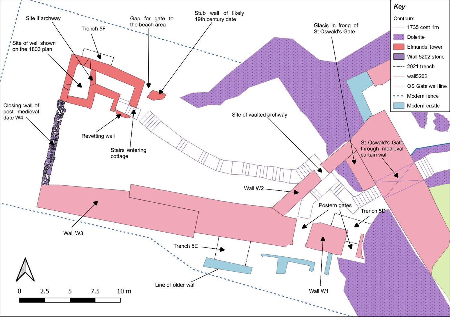
The south Wall (W1 and W3) comprised at least two build elements that joined with an overlapping joint. The wall as we now know through excavation had two postern gates that would have led to the village.

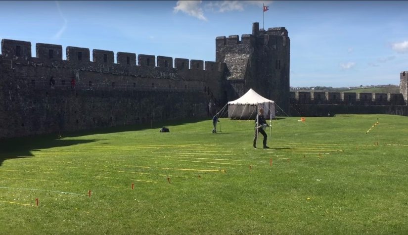
In addition to the masonry and photogrammetry survey, Dr Kristian Strutt undertook magnetometry, resistivity and Ground Penetrating Radar (GPR) survey of areas of the Cricket Ground to the west of Bamburgh Castle. The results indicate the possible presence of a large ditch, some 45m across, immediately to the west of the outcrop, in addition to trackways, walls and other features.

Figure 4: GPR survey under way across the Cricket Ground using an Impulse Raptor 8-channel system and GPS (photo: K. Strutt)

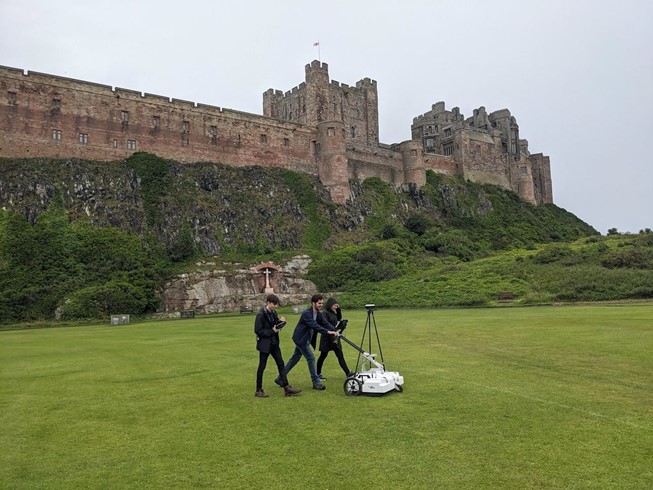
One of the principal questions we were hoping to address with the geophysics was if the castle ditch extended across the sports field at the base of the castle rock. A ditch cut through sandstone can been traced in the area of the modern entrance that is at the site of the 12th century gate. This feature extends across the front of the castle as far as the sandstone ridge. The results of the GPR seem to strongly indicate a large feature in the area where we would anticipate the castle ditch to be and the magnetometry and resistance surveys seem to support this. It is intended to conduct further fieldwork, starting with coring, to confirm this.

Subscribe to our quarterly newsletter

In addition, several features seen on the 1865 1st Edition Ordnance Survey (Accessed via National Library of Scotland online 23/04/2024) appear to be picked up on the surveys. Two trackways are evident, that lead to St Oswald’s Gate and to a cleft in the castle rock called the ‘Miller’s Nick’, which allowed people to scramble up to the West Ward in the 19th century. The second is an S-shaped path that meandered towards the area of St Oswald’s Gate, perhaps originally skirting around the edge of the ditch feature. One further route-way or path extends across the field parallel to the road in the village to the south, called the Wynding, that appears from records to have had a medieval origin. This path runs alongside a linear plot boundary and field boundaries and it will be interesting to see if more can be made from a number of anomalies within the enclosure areas to the south and west of the plot.

Figure 5: Interpretation plot of all three surveys, labels link to the text in the Interim Report and Geophysical Survey Report. Map Data: Google ©2023, Airbus 11/05/23

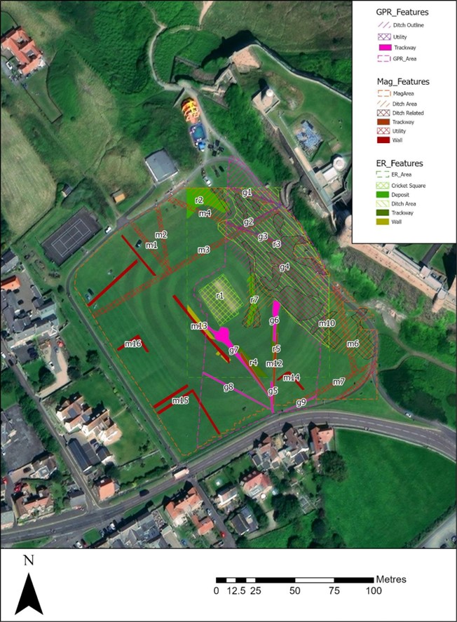
The resistivity and ground penetrating radar surveys so far cover a more limited area, due to time constraints and public access. There is an area of low resistance that lies just where the ditch would lie and matches up to the path towards the Miller’s Nick. The enclosure areas picked up in the magnetometry to the south-west also seems to be present on the resistivity. Notably, there is a high resistance feature that the S-shaped pathway may curve deliberately to avoid at the south part of the plot. A further T-shaped high resistance feature is present in the north-east extending from the area of the modern pavilion that will bear further study. The GPR further reinforces the presence of some of these features and indicates some depth to the anomaly that is interpreted as the ditch, though the signal attenuates before it could indicate a true depth.

Together, the on-going excavation and non-invasive survey work undertaken in 2023 are providing us with the opportunity to better understand the castle outworks, north of the castle, and the wider environs in which they were situated. That this area of the castle was its original entrance, and for a time gave access to a modest port, ensures that there is much yet to be discovered and understood.

Interim Report

If you would like to read more about the excavation, masonry survey & 3D models and/or the results of the geophysical survey with accompanying discussion, please take a look at

Surveying Bamburgh Castle’s Elmund’s Tower | Castle Studies Trust

We are incredibly grateful to the Castle Studies Trust for their generous support.

Subscribe to our quarterly newsletter

References

  • Colvin, H. M. 1973. The History of the King’s Works, London: HMSO
  • Map Data: Google ©2023, Airbus 11/05/23
  • Ordnance Survey Sheet XVII 1865 (Accessed via National Library of Scotland online 23/04/2024: https://maps.nls.uk/view/102346251)
  • Ryder, P. 2024. Preliminary Assessment of the Standing Masonry Elements: St Oswald’s Gate, the Western Outwork and St Elmund’s Well Tower, Bamburgh Castle, Unpublished Report
  • Strutt, K and Barker, D. 2024. Report on the Geophysical Survey at Bamburgh, Northumberland, July 2023Department of Archaeology, University of Southampton: Unpublished Report
  • Symeon, H. K. Historia regum Anglorum et Dacorum (trans. J. Stevenson), 1858, Church Historians of England

The Castle Studies Trust five projects for 2023

The Castle Studies Trust have awarded five grants totalling £35,000 to support research into castles. This is a record amount for the Trust, and as we enter our tenth year as a charity, we could not have managed this without our supporters.

We will bring you updates from these projects throughout the year as the teams get stuck in. But first, let’s get to know them a bit better. They are from across England, Scotland, and Wales and take different approaches to understanding castles.

Subscribe to our quarterly newsletter.

Bamburgh

A stone building with a square tower in the middle. It stands on an outcrop, prominent in the landscape. In the foreground is a beach.
Bamburgh Castle on the coast of Northumberland. Photo by Michael Hanselmann via Wikimedia Commons, licensed CC-BY-SA 3.0.

Standing on a rocky outcrop on the coast of Northumberland, Bamburgh’s history stretches back to the early medieval period when it was home to a palace of the Kings of Northumbria. Bamburgh Castle itself was owned by royalty at various points, and rebuilt in the 18th century.

Bamburgh is a massive site: its history has been illuminated by excavations, and there is still more to learn.

Dr. Joanne Kirton and Graeme Young of the Bamburgh Research Project plan to carry out a geophysical survey and a masonry survey of the castle’s outworks.

Dunoon

The mound at Dunoon Castle. Photo by Rosser1954 via Wikimedia Commons, licensed CC-BY-SA 4.0.

A castle at Dunoon was first mentioned in the late 13th century but may be older. The ruins visible today date from the 14th century. It stands on a hill on the coast of the Firth of Clyde. The castle was besieged and captured multiple times over its centuries-long history and became a royal residence.

Despite the castle’s royal links, little is known about its layout and dating. Dr. Manda Forster’s team at DigVentures will carry out geophysical surveys (resistivity and magnetometry) of the mound and the area around it to find out where there may be buried walls, foundations, or other archaeological remains.

They will also organise workshops for the local community to learn how geophysics work. So as well as learning more about the castle, they may inspire the next generation of archaeologists!

Lowther

Google Map of the medieval Lowther Castle

The present Lowther Castle was built in the 17th century, but a few hundred metres north lie the medieval remains of a castle and possible deserted village. Lancaster University Archaeology Unit surveyed the earthworks in the 1990s, but there has been no other archaeological investigation since.

Being able to date the site would be a crucial step in understanding the Norman influence in the region. Could this be part of the remains of the Norman conquest of the Kingdom of Cumbria in the late 11th century?

Dr. Sophie Ambler has devised the project to carry out geophysical surveys at Lowther Castle followed by excavations. Working with the University of Central Lancashire and Allen Archaeology, this aims to establish the site’s building chronology.

Picton

Picton Castle in 2021 by Ruth Sharvile, via Geograph. Licensed CC-BY-SA 2.0.

Pembroke’s Picton Castle is a medieval building with later alterations and additions. It is uncertain when it was built and by who, but it is likely to have been established in about 1300 by Sir John Wogan. Picton has an unusual layout but may have parallels with French medieval castles.

Neil Ludlow and the Dyfed Archaeological Trust will carry out a measured survey of the building, recording its structure and creating a photographic record of the site. This will be an invaluable resource to understand the site, and help show the castle’s development over the centuries.

Wigmore

Photo of Wigmore © Philip Hume

Wigmore was amongst the early castles established in England in the wake of the Norman conquest. It was founded by William Fitz Osbern, Earl of Hereford and later became the home of the Mortimer family. They were an influential family in the Welsh marches, and they developed the castle to reflect their growing power.

Small-scale excavations at Wigmore and geophysical surveys in the 1990s demonstrated the archaeological potential of the site, but what is missing is a reconstruction of how it looked during its heyday.

Chris Jones-Jenkins will create a reconstruction of how Wigmore Castle used to appear. This will draw on archaeological and historical sources to bring the reconstruction to life. You may also have seen Chris’ work with his reconstructions of Ruthin and Holt.

Subscribe to our quarterly newsletter to receive updates on these projects and our other ongoing work in the field of castle studies.

Header image: Bamburgh Castle by Michael Hanselmann via Wikimedia Commons, licensed CC-BY-SA 3.0.

A large and eclectic crop of fascinating applications asking for over £100,000 for the Castle Studies Trust to Consider

The deadline for grant applications passed on 1 December. We’re going through the various projects now. Altogether the 15 projects, coming from all the home nations and one from Ireland, are asking for over £110,000. They cover not only a wide period of history but also a broad range of topics.

We will not be able to fund as many of these projects as we would like. To help us fund as many of these projects as possible please donate here:

Kindlink Donation Form App

In a little more detail here are the applications we’ve received:

Bamburgh, Northumberland: The aim of the project is to better understand the outworks to the north of the castle, by using various geophysical survey techniques and a preliminary survey of the masonry remains, it will include a 3D model of the recently excavated Elmund Tower and provide materials for interactive displays.

Barnard Castle, Co Durham: The aim of the project is to try and understand a lot more about the outer ward of the castle, using a variety of methods including geophysical survey, aerial survey and test excavation

Cavers Castle, Roxburghshire: Through a combination of building survey and excavation to try to understand the early form of this important baronial castle.

Dunoon, Argyll: A community-led geophysical survey project to understand better the form and scale of this important castle that was the seat of the Lord High Stewards of Scotland. The original castle dates back to the 1200s and the remains above currently ground date from the fourteenth century.

Fun Kids, Castle Podcasts for 7-13 Year Olds: To produce a series of 8 podcasts for children aged 7-13 to engage children to explore a what, how and why of 8 castles. The series will focus on a variety of castles and build awareness of less common castles that families can explore.

Galey, Co. Roscommon: Geophysical and topographical surveys to explore the possible motives behind the placement of, as well as immediate landscape context, morphology and any attached settlement and industrial activity, that occurred at a lakeshore-sited late medieval Gaelic-constructed tower house castle.

Hartlebury, Worcestershire: The seeks to explore what looks like a possible civil war bastion ditch, which seems to have been partially revealed in a 2022 drone survey of this former bishop’s palace with remains dating from the fifteenth century. This will be done through geophysical survey and excavation.

Lowther Castle, Cumbria: Through a combination of geophysical survey and excavation to try to learn more about this ringwork castle and settlement, thought to date from the late eleventh century. the aim is to try to discover if it dates from this period and was therefore a Norman plantation; and also its history after its foundation.

Millom, Cumbria: The project will involve a drone survey to assess the condition of the 14th century fortified manor combined with a geophyisical survey to understand if there is any link between it and the nearby church and monastery.

Muncaster, Cumbria finds assessment: To make a complete assessment of the finds from the 2021 excavations which took place near the 14th century tower along with two nearby kiln sites.

Muncaster, Cumbria geophys and archaeology survey: To carry out a geophysical survey of the area surrounding the castle and to investigate a large stone feature in the cellar of the castle to understand its purpose and possible date

Northern Frontier, Beacon Hill Yorkshire: A geophysical survey of Pickering Beacon Hill, a siege castle used for the siege of Pickering in the lead up to the Battle of the Standard (1138) to better understand the landscape at the time and see how much life was disrupted during the period known as the Anarchy.

Picton, Pembrokshire: The aim of the project is to achieve a full understanding of the form, functions and affinities of the medieval part of Picton Castle through a building survey. It has an unusual plan with no close parallels within Great Britain, but shows some affinities with castles further afield including, possibly, Gascony in France

Snodhill, Herefordshire: Excavation to explore the early masonry defences and attempt to resolve the entrance arrangements and to do a geophysical survey of the Eastern Bailey

Wigmore, Herefordshire: To provide a digital reconstruction drawing of Wigmore Castle using a mixture of archaeological and archival evidence

We will not be able to fund as many of these projects as we would like. To help us fund as many of these projects as possible please donate here: Kindlink Donation Form App

The applications have been sent to our assessors who will go over them. You can see how the assessment process works from our blog back in January 2016: How the Castle Studies Trust Selects its Projects – Castle Studies Trust Blog

Barns in the Bailey: Agricultural buildings within castles

Castles were more than military sites, being political, judicial and economic centres too. Duncan Berryman of Queen’s University Belfast looks at one of those aspects, the important but little studied area of agricultural buildings in castles.

The domestic considerations of castles were as important to daily life as their defensive functions. Castles were also the centres of estates; Clare Castle (Suffolk) is a good example of an estate centre with manors in the surrounding region and further afield while Caister Castle (Norfolk) was the centre of a much more compact estate. Manorial centres were generally undefended courtyards of domestic and agricultural buildings. However, many of these were moated sites and their lack of defensibility might be debated. Sites such as Chalgrove (Oxfordshire) and Coolamurry (Wexford) had substantial moats and may have had complex bridges (Page et al. 2005; Fegan 2009). These complexes saw high-status accommodation sitting alongside the barns and animal housing that served as the manorial farmyard. Many smaller castles would have been the centres of smaller estates and would have also functioned as manorial centres. Agricultural buildings were vital to this operation and would have been found within baileys or associated enclosures. To investigate these buildings, it is essential to take a multidisciplinary approach by combining archaeology with documentary and pictorial evidence. The agricultural buildings have often been left unexcavated as they are seen as less important, and less interesting, than the domestic complexes.

Artistic reconstruction of Clough Castle (Down). Many motte and baileys would have had a similar appearance, often with timber structures on the motte instead of the masonry buildings presented here.

Documentary sources related to Ireland indicate that many smaller castle sites had agricultural buildings within the surrounding area. This is clearly illustrated at Cloncurry (Kildare), where an extent records that beside the motte was “an old haggard close [farmyard] in which there are two small granges [barns] each of eight forks … [t]here is also there, beside the gate an ox-house … [and t]here is a dovecote” (Murphy & Potterton 2010, 175). There is also a record of a barn of ten forks at Castlemore (Carlow), as well as a mill and other timber and masonry buildings (O’Conor 1998, 32). The forks referred to in these accounts are probably the cruck blades of the barn, thus ten forks produce a nine-bay barn that could be the equivalent size of a barn like Bredon (Worcestershire). At Lough Merans (Kilkenny), the motte sat on a promontory in the lake and had an associated bailey containing a granary, stables, and a sheepcote (O’Conor 1998, 30). The motte of Inch (Tippararery) also had a granary and sheepcote, additional buildings were stables, a fish-house, a dovecote, and a malt kiln (O’Conor 998, 29). These examples suggest that, in Ireland, castles were playing important roles as the centres of manorial farms and wider estates. The perceived need for a defensive motte may have been carried over from an earlier period, but it continued with the construction of tower houses in the fifteenth and sixteenth centuries (McAlister 2019, 28-35).

Bredon Barn (Worcestershire). Barns of a similar size were found within castle baileys. They would have been constructed from masonry or timber

A brief survey of larger castles in England does show that these castles had a small number of agricultural buildings. The main buildings identified were stables, dovecotes, barns, and granaries. These buildings are unlikely to have functioned in the same way as they did in rural manorial centres, but they are a reminder that some agricultural processes occurred within the castle. Stables were obviously for housing the riding horses of the lord or king and their entourage, but they probably also housed the cart horses used by the castle staff to bring goods in from the market. There are records of stables at Hereford, Leeds (Kent), Leicester, Lincoln, Nottingham, and the stables of Kenilworth (Warwickshire) are still extant (Colvin 1963). The dovecote was an important source of food in the form of squabs (young pigeons). A dovecote was recorded at Dorchester (Dorset) and one has been identified in the south-west tower of Bodiam (Sussex) (Colvin 1963; Thackray 2003). The existence of barns might suggest that sheaves of wheat or barley were being brought into the castle and threshed there, providing grain for flour and straw for the stables and other floors around the castle. There is evidence for barns at Acton Burnell (Shropshire), Bamburgh (Northumbria), Hadleigh (Essex), Weoley (Warwickshire), and Pontefract (Yorkshire) (Colvin 1963; Emery 2000; Roberts 2002).

The stables of Kenilworth castle (Warwickshire). This was a particularly grand building, but stables were vital for the lordly lifestyle.

The c.1610 plan of Castle Hedingham (Essex) indicates that there may have been an agricultural complex beside the main castle enclosure (Emery 2000, 113). To the top of the map are buildings labelled stable and barn and an area marked barnyard, in manorial sites this would indicate a complex of crop storage buildings including several barns and a granary. Returning to Clare Castle, the 1325 accounts of the constable indicate that there were a pigsty and poultry house within the castle compound (Ward 2014, 64).

Agricultural buildings are found in areas away from the main domestic complex of the castle, and these areas are often left unexcavated. They were most often made of timber, and thus leave little trace in the archaeology compared to the stone-built structures elsewhere. It is possible that there were more agricultural buildings within castles, or close to them, and they have not yet been identified. This research highlights the importance of using documentary and pictorial sources alongside archaeology and reminds us that lesser castle complexes may have been surrounded by a significant range of buildings.

Subscribe to our quarterly newsletter

References

Colvin, H.M. (ed.) 1963, The History of the King’s Works Vol I & II (London: Her Majesty’s Stationary Office).

Emery, A. 2000, Greater Medieval Houses of England and Wales II (Cambridge: Cambridge University Press).

Fegan, G. 2009, ‘Discovery and excavation of a medieval moated site at Coolamurry, C. Wexford’, in C. Corlett & M. Potterton (eds), Rural Settlement in Medieval Ireland in the Light of Recent Archaeological Excavations (Dublin: Wordwell Books).

McAlister, V. 2019, The Irish Tower House: Society, Economy and Environment c.1300–1650 (Manchester: Manchester University Press).

Murphy, M. & Potterton, M. 2010, The Dublin Region in the Middle Ages: Settlement, Land-Use and Economy (Dublin: Four Courts Press).

O’Conor, K.D. 1998, The Archaeology of Medieval Rural Settlement in Ireland (Dublin: The Discovery Programme).

Page, P., Atherton, K. & Hardy, A. 2005, Barentin’s Manor: Excavations of the moated manor at Harding’s Field, Chalgrove, Oxfordshire 1976–9 (Oxford: Oxford Archaeology Unit).

Roberts, I. 2002, Pontefract Castle: Archaeological Excavations 1982–86 (York: West Yorkshire Archaeology Service).

Thackray, D. 2003, Bodiam Castle (Swindon: The National Trust).

A Large and Eclectic Crop of Fascinating Applications for the Castle Studies Trust to Consider

The deadline for grant applications passed on 30th November. We’re going through the various projects now. Altogether the 13 projects, coming from England, Ireland, and Scotland are asking for over £88,000. They cover not only a wide period of history but also a wide range of topics. In a little more detail, here are the applications we’ve received:

Bamburgh, Northumberland

Photo by Thomas Quine, licensed CC BY 2.0.

The main aim is to recover evidence for the base natural topography around the approach to the main gate of the once royal castle, from the area of the medieval village, and explore how this was altered, presented and exploited to create a sense of theatre for visitors to the site.

Berkhamsted, Hertfordshire

Photo by Sean Wallis, licensed CC BY NC 2.0.

A geoarchaeological auger survey of the moats that surround this former royal castle and palace of Thomas Becket. The survey aims to answer such questions as what were the moats original profiles, when were the moats filled and how do the two moats compare with each other.

Dunollie, Argyll

Photo by Paul Lloyd, licensed CC BY NC SA 2.0.

To try and understand the date of the construction of the castle owned by the MacDougall clan through various through buildings and materials analysis including radiocarbon dating and mortar analysis.

Fraoch Eilean, Loch Awe

Photo by Andrea Hope, licensed CC BY SA 2.0.

To try and understand the date of the construction of the former royal castle through various through buildings and materials analysis including radiocarbon dating and mortar analysis.

Hoghton, Lancashire

The aim of the project to continue the work the CST funded in 2019 with excavations and building survey. Further excavations will try and understand the purpose of the structures found in the 2019 excavation season and if they were related to the original great tower.

Holme Pierpont, Nottinghamshire

To build up an understanding of this late medieval great house, never previously researched. The work will include a mixture of desk research, building survey and geophysical survey of the parkland surrounding it. The house is the most complete of the three late medieval brick-built houses in Nottinghamshire.

Lincoln, Lincolnshire

Photo by Ben Keating, licensed CCY BY NC SA 2.0.

To develop a reconstruction drawing of the castle as it would have appeared in the second half of the 12th century. Lincoln Castle was founded by William the Conqueror in the late 11th century.

Shrewsbury, Shropshire

To fund a second year of excavation, this time to understand the rampart of the inner bailey. The geophysical survey carried out in the 2019 suggested there could be remains of buildings there, possibly even a late Saxon church. Shrewsbury was a very important border castle up until the 13th century and frequently used as a base for English raids into Wales.

Sowing the Seeds

Hortus conclusus depicted by Meister des Frankfurter Paradiesgärtleins

The aim of the project is to try and understand better everyday life in castles by seeing if there are any surviving plants at four Irish castles that were planted, grown and cared for by medieval people. The research will involve ecological surveys at each location.

Strongholds of Wessex

Photo of Silbury Hill by Greg O’Beirne, licensed CC BY SA 3.0.

The aim of the project is to understand the military organisation of the northern part of Wessex (Wiltshire and West Oxfordshire) from the transition from Saxon to Norman rule between the 9th and 12th centuries. The work will involve documentary research, landscape and place name surveys. Sites examined will include Castle Combe, Cricklade and Silbury Hill.

The Wirk, Orkney

Rousay - The Wirk

Could the Wirk be a Norse castle? Based on the island of Rousay, this stone tower is situated close to the old parish church and recently discovered Norse Hall. However, no one knows what this tower was used for or even when it was built. The work would involve a geophysical survey of the surrounding area as well as two trial trenches to try and find dating evidence.

Thermal Imaging of Castles

A thermogram of Cirencester Roman amphitheatre by Dr John Wells, licensed CC BY SA 4.0.

To test how useful thermal imaging could be in understanding castles. The thermal survey using a FLIR camera of two castle facades in different climates. within the UK—Caisteal Uisdein, on the coast of Loch Snizort, and a castle farther south and slightly inland, Castle Rising.

Warkworth, Northumberland

Photo by Barry Marsh, in the public domain

Using various forms of geophysical survey to try and understand the subsurface features for the former caput of the Dukes of Northumberland. The survey will focus on the bailey inside the 12th-century curtain wall as well as the strip of land outside but on the early earthwork castle, the motte and field near the entrance to the castle.


The applications have been sent to our expert assessors who will go over them. And if you want to know more about how the assessment process works, we have a brief summary.

2017 grants: who has applied?

The deadline for grant applications passed on 15th December and we’re going through the various projects now. Altogether the 11 projects, coming from all parts of the British Isles and Italy, are asking for over £50,000. They cover a wide period of history and types of research. For a little more detail, here are the applications we’ve received:

  • Abergavenny Castle, Wales – a geophysical survey of the whole site. The castle was an important baronial site and saw a lot of military action from when it was first built in the 11th century up until it was slighted (partially demolished) in the Civil War.
  • Bamburgh, England – assess and conserve a large collection of medieval metal work dating from the 8th to the 11th century discovered in the west ward. Bamburgh was a major elite fortress from the early medieval period so the project should help potentially understand how the site changed over the centuries.
  • Caldicot Castle, Wales – geophysical of the whole scheduled area. Building on the previous resistivity survey in the project will use all three types of survey technique to get the best understanding of any below ground remains of this major baronial site.
  • Castle Pulverbatch, England – geophysical and photogrammetric surveys of the site, one of the finest examples of a Norman motte-and-bailey castle in Shropshire.
  • Clifford Castle, England – geophysical survey and excavations to help understand the morphology of one of the earliest castle sites in the UK, and one of the principal castles on the Anglo-Welsh border. Please note this is a privately owned site and not accessible to the general public.
  • Dinas Bran, Wales – geophysical survey of the most extensive and complete Welsh-built castle to understand what structures lie beneath the surface.
  • Edinburgh Castle, Scotland – mapping and categorising suspected conflict damage at this iconic castle.
  • Fotheringhay, England – understanding the morphology of the caput of the honor of Huntingdon and 15th-century palace associated with the House of York and birthplace of Richard III, using ground penetrating radar and small unmanned aircraft. Please note this is a privately owned site and not accessible to the general public.
  • Lathom House, England – analysis of masonry dating from the late 15th-century castle built by Thomas, Lord Stanley either found via excavations or potential reused in the current building.
  • Lecce, Italy – to help with the publication of a history of the castle of Lecce which was founded by the Normans.
  • Lough Key, Ireland – to improve understanding of the medieval MacDermot lordship of Moylurg and its relationship with the Rock of Lough Key.

The applications have been sent to our expert assessors who will go over them. You can see how the assessment process works from our blog back in January 2016.