Exploring Shrewsbury Castle

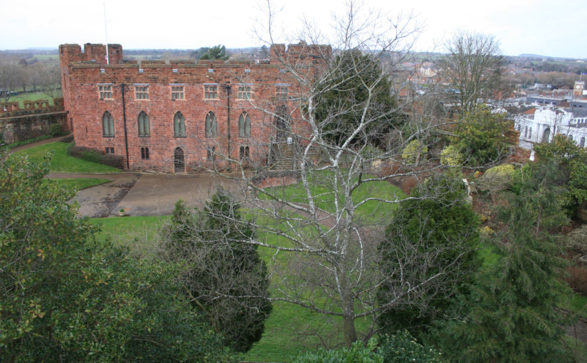
This year we’re funding investigations at Shrewsbury Castle, one of the most important castles along the Anglo-Welsh border. Nigel Baker told us how the work has been going.

Phase 1 of the Castle Studies Trust’s Shrewsbury Castle 2019 project is underway. Archaeological research is a long and painstaking process, so instant results are not to be expected – it must have taken a whole three hours to establish for the first time a number of simple but really fundamental facts about the hitherto-unexplored inner bailey.

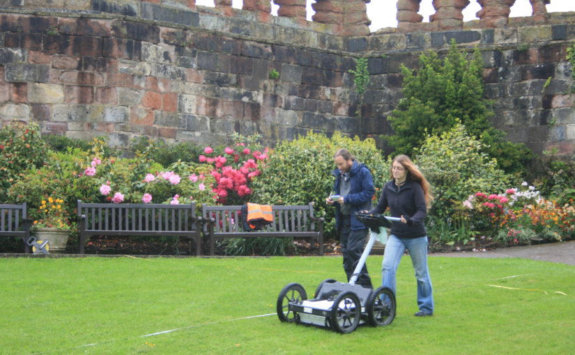
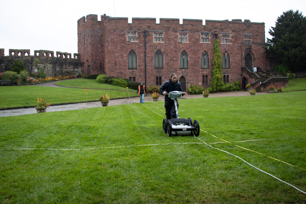
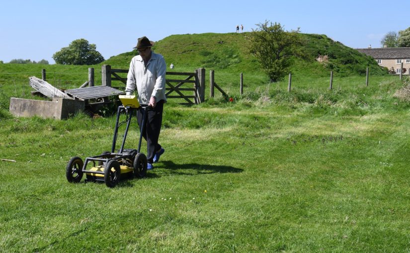
Work started on Wednesday 8th May with the arrival at the castle of Tiger Geo, specialist geophysical survey contractors. Using ground-penetrating radar and resistivity, the lawns of the inner bailey interior and the slopes of the ramparts were gridded out and surveyed; the geophysicists never stopped, nor did the rain. But two basic conclusions emerged on screen from the raw data.

Tiger Geo doing sterling work despite the weather.

The first is that a ditch did once encircle the base of the motte within the perimeter of the inner bailey. This implies that the flat area within the inner bailey must originally have been a crescent-shaped area less than twenty metres wide from motte ditch to rampart tail.

The second conclusion is that there is, under the grass opposite and parallel to the standing early 13th-century ‘Great Hall’ (which houses a very fine Regimental Museum), another big building range backing onto the motte ditch. Given that the standing first-floor Great Hall was built as a royal chamber block (‘camera’) in the 1230s-40s, there is a possibility that a real Great Hall awaits excavation in the summer. But we’ve already answered one of the project’s main questions, ‘how was the inner bailey planned?’ The answer is there were two main ranges of buildings and no room for anything else.

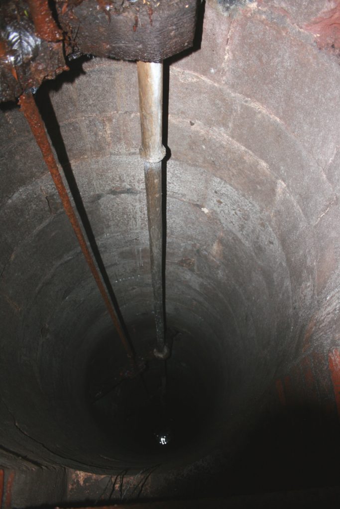
While Tiger Geo mowed the lawns, the writer was busy in a bush at the base of the motte, freeing-up a manhole cover sealed for a decade. Under, a 20th-century brick inspection chamber gives access to a stone well-shaft alongside. The writer had been shown it surreptitiously by a kind gardener in the 1990s but without the opportunity for much recording. Now it has been photographed (though not with stunning competence), measured at just over seventy feet deep from ground level down to water level, and the masonry identified as probably late medieval – and not something done by Thomas Telford in the 1790s. So – Shrewsbury Castle retains its medieval well.

The medieval well. It’s a dizzying 21m down to water level.

To stay up-to-date with our work, subscribe to our newsletter.

Five New Awards and £100,000 in six years

We are excited to announce five grants totalling a record £27,000 that will advance our understanding of castles. These awards mean we have reached the landmark of giving away £100,000 in grants. It has taken six years for us to do that during which time the Trust has doubled the maximum amount we can award to £10,000.

Before you read about the five projects below, be sure to subscribe to our newsletter if you haven’t already.

  • Druminnor, Aberdeenshire – Using GPR for an investigation of the 15th century core of the castle – presently under a hardcore car park. This was the original caput of the lords of Forbes. During the 15th century they were amongst the most powerful families in the North-east of Scotland.
  • Hoghton Tower, Lancashire – This project aims to form an axis of research into Hoghton Tower’s unique physical history. The main focus will be to investigate and advance the knowledge of the pre-1560 site and specifically try to test the hypothesis that the north side building may form part of the ‘original’ Hoghton Tower.
  • Laughton en le Morthen, South Yorkshire – Excavation to try to confirm the findings of the geophysical surveys the CST funded in 2018. These indicated that the castle was placed right on the top of a high status Saxon dwelling.
  • Shrewsbury, Shropshire – Geophysical survey and excavation to determine how the castle buildings were laid out in the bailey. This will be the first time the well preserved motte-and-bailey castle has been excavated. First mentioned in 1069, Shrewsbury Castle was a key point along the Anglo-Welsh border and fell into ruin following the conquest of Wales.
  • Wressle, East Yorkshire – A geophysical survey of the area to the south of the castle ruins which had been covered by the previous earthwork survey funded by the CST, to get more information about the various garden structures there, as well as other details regarding the deserted village, moat and fishponds. The 14th century castle was one of the most important castles owned by the Earls of Northumberland.

Be sure to follow us on social media where we’ll be bringing you updates from the field, with work starting this month. In the meantime, here are some of our supporters discussing our work. we hope you’re looking forward to this year’s projects as much as we are!

The projects we’re considering for 2019

The deadline for grant applications passed on 30th November. We’re going through the various projects now. Altogether the 12 projects, coming from all parts of Britain and one from Ireland, are asking for over £75,000.* They cover not only a wide period of history but also a wide range of topics. In a little more detail, here are the applications we’ve received:

Collyweston, Northamptonshire

  • Contributing towards a community excavation at the early Tudor palace commissioned by Henry VII’s mother, Margaret Beaufort. According to building accounts the palace was built around three courtyards and was the first brick building in Northamptonshire. The palace was demolished in 1640 and the site has never been excavated before.

Druminnor, Aberdeenshire

[10] Druminnor Castle - "Woops!"
Using Ground Penetrating Radar for an investigation of the 15th-century core of the castle – presently under a hardcore car park. This was the original caput of the lords of Forbes. During the 15th century they were amongst the most powerful families in the North-east of Scotland.

Hoghton Tower, Lancashire

hoghton tower
This project aims to form an axis of research into Hoghton Tower’s unique physical history. The main focus will be to investigate and advance the knowledge of the pre-1560 site and specifically try to test the hypothesis that the north side building may form part of the ‘original’ Hoghton Tower.

Lathom, Lancashire

Excavation to establish the form and location of the southern perimeter of the curtain wall of the 15th-century castle known as the Northern Court of which nothing remains above ground from the period. It was one of the most important castles in the north west of England in the late 15th and 16th centuries. The castle was besieged twice in the English Civil War and then slighted. In 2017 we funded analysis of masonry recovered in earlier excavations, which indicated architectural links with Caernarfon Castle.

Laughton en le Morthen, South Yorkshire

Photo by Mike Neid

Following on from last year’s grant, this project would undertake excavation to investigate features identified during the geophysical survey. The survey suggested that the castle was built over an Anglo-Saxon lordly residence, and the excavation would test whether there is further evidence to corroborate this.

Lewes, East Sussex

Photo by Richard Gailey, licensed CC-BY 2.0.

This research aims to answer an intriguing question: why does Lewes Castle, East Sussex, have two mottes? Do they represent a highly distinctive architectural statement, or did burial mounds of possible Romano-British or earlier origins influence the form of the 11th century fortification?

Loughmoe, County Tipperary

Castles of Munster, Loughmoe, Tipperary - geograph.org.uk - 1542634
To produce the first-ever detailed survey and structural history of the building which dates from the 15th and 16th centuries, and to determine using geophysics the extent of the original castle and whether the renaissance part had a precinct, other buildings, and gardens.

Raglan, Monmouthshire

Photo © Jeremy Cunnington

Using inferences from previous geophysical surveys to focus on key areas of the lower terraces and bowling green of the castle potentially revealing more about the clandestine political activity of the Somerset family in the late 16th and 17 centuries.

Shrewsbury, Shropshire

Shrewsbury Castle looking West
Geophysical survey and excavation concentrating on the inner bailey to in particular examine the tail of the north rampart. Despite being one of the main fortresses on the Welsh border no major excavations have taken place in the bailey. Thus the medieval plan of the enclosure, and the missing domestic ranges that should be there, are completely unknown.

Snodhill, Herefordshire

Photo © Jeremy Cunnington

Excavations in this important Welsh border fortress that was in use from just after the conquest to the English Civil War. The aim is to answer some key questions about the castle e.g. the keep’s entrance and final form, to establish the form of the North Tower and along the south side to see if that was where the entrance was.

Tarbert, Argyll

East Loch Tarbert and Tarbert Castle - geograph.org.uk - 1624617
Funding post-excavation costs of a community archaeology project. The project will be trying to see discover a number of things about this royal castle including if there was a southern entrance into the outer bailey, and what buildings there were along the north east range of the inner bailey.

Wressle, East Yorkshire

A geophysical survey of the area to the south of the castle ruins which had been covered by the previous earthwork survey funded by the CST, to get more information about the various garden structures there, as well as other details regarding the deserted village, moat and fishponds. The 14th century castle was one of the most important castles owned by the Dukes of Northumberland.

The applications have been sent to our expert assessors who will go over them. You can see how the assessment process works from our blog back in January 2016. And don’t forget to subscribe to our newsletter.

*The article was updated at 15:28, 10th December to remove Halton Castle.