What lies beneath: what a ground penetrating radar survey reveals of Druminnor Castle

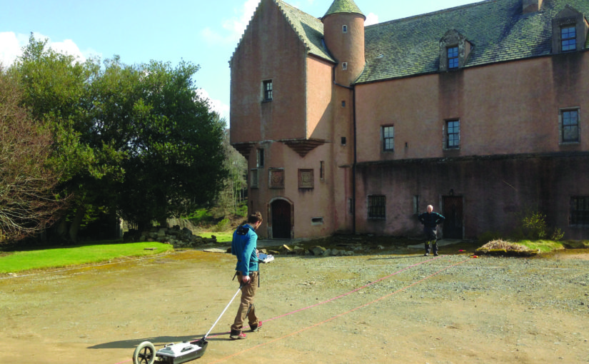
Lead Archaeologist on the Druminnor Castle excavation, Dr Colin Shepherd, looks at the results of the ground penetrating radar (GPR) survey of the castle in funded by the Castle Studies Trust in 2019 and what that means for future work at the site.

As a consequence of the GPR geophysics, that were generously funded by the Castle Studies Trust, we have a number of new and potentially interesting anomalies to be investigated. Furthermore, the GPR research has also been instrumental in clarifying other aspects of previously excavated evidence. This has been made possible as, contrary to most instances, the geophysics at Druminnor have been incorporated into the ongoing investigation rather than simply as a precursor to excavation.

Subscribe to our quarterly newsletter

The GPR generated 286 ‘radargrams’ or sections across the site and much time and effort has gone into analyzing these. The radargrams were compared to actual excavated sections. This permitted the creation of a ‘key’ that has allowed us to extrapolate from the excavated sections to unexcavated parts of the site. As a result, we can, fairly comfortably, suggest a developmental plan of Druminnor spanning the 13th to 18th centuries (Figure 1).

Suggested phasing of Druminnor Castle by Colin Shepherd

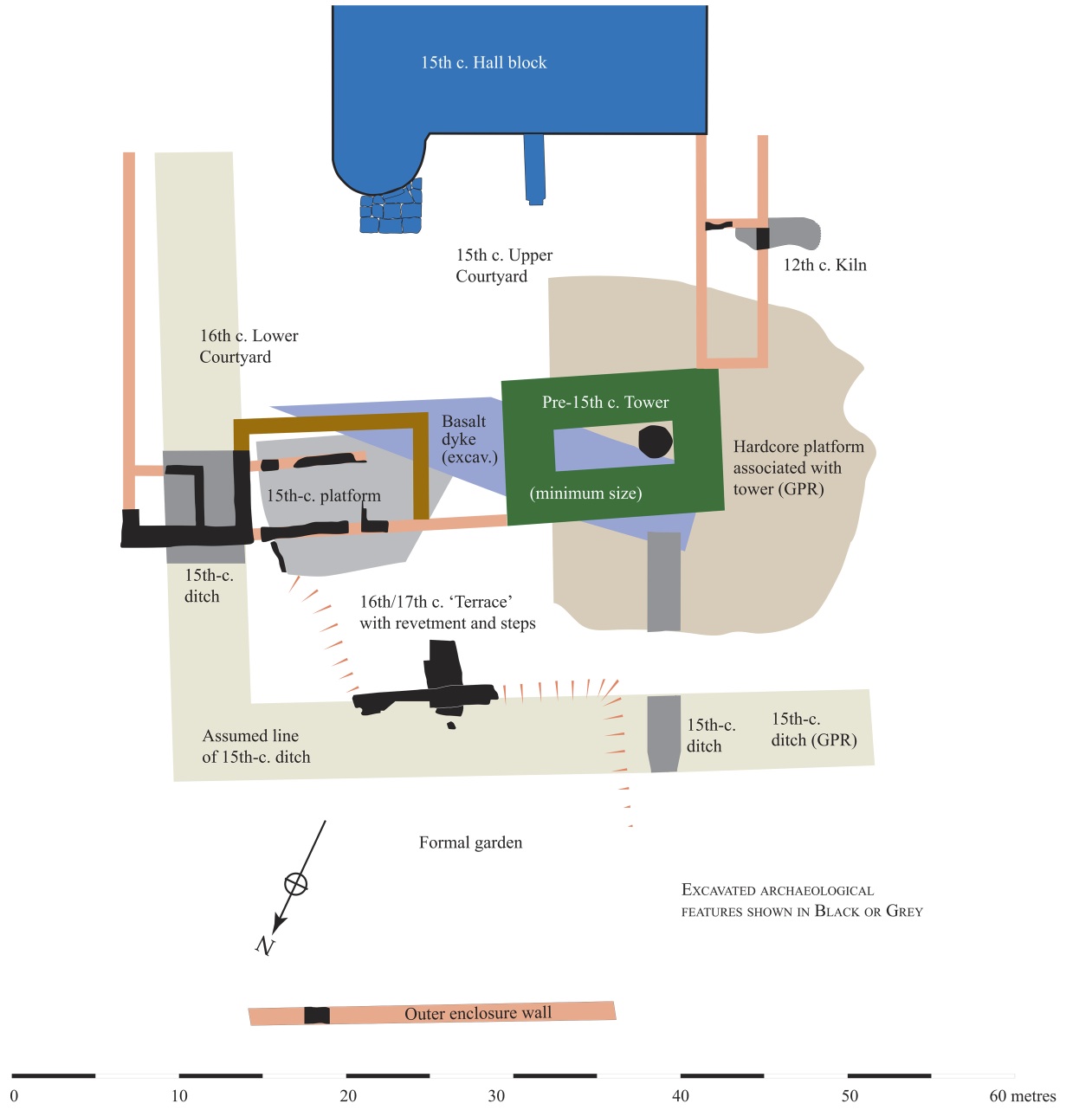
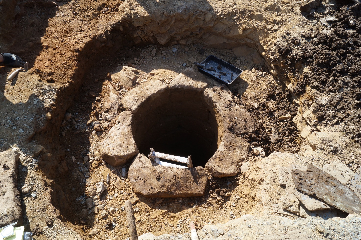
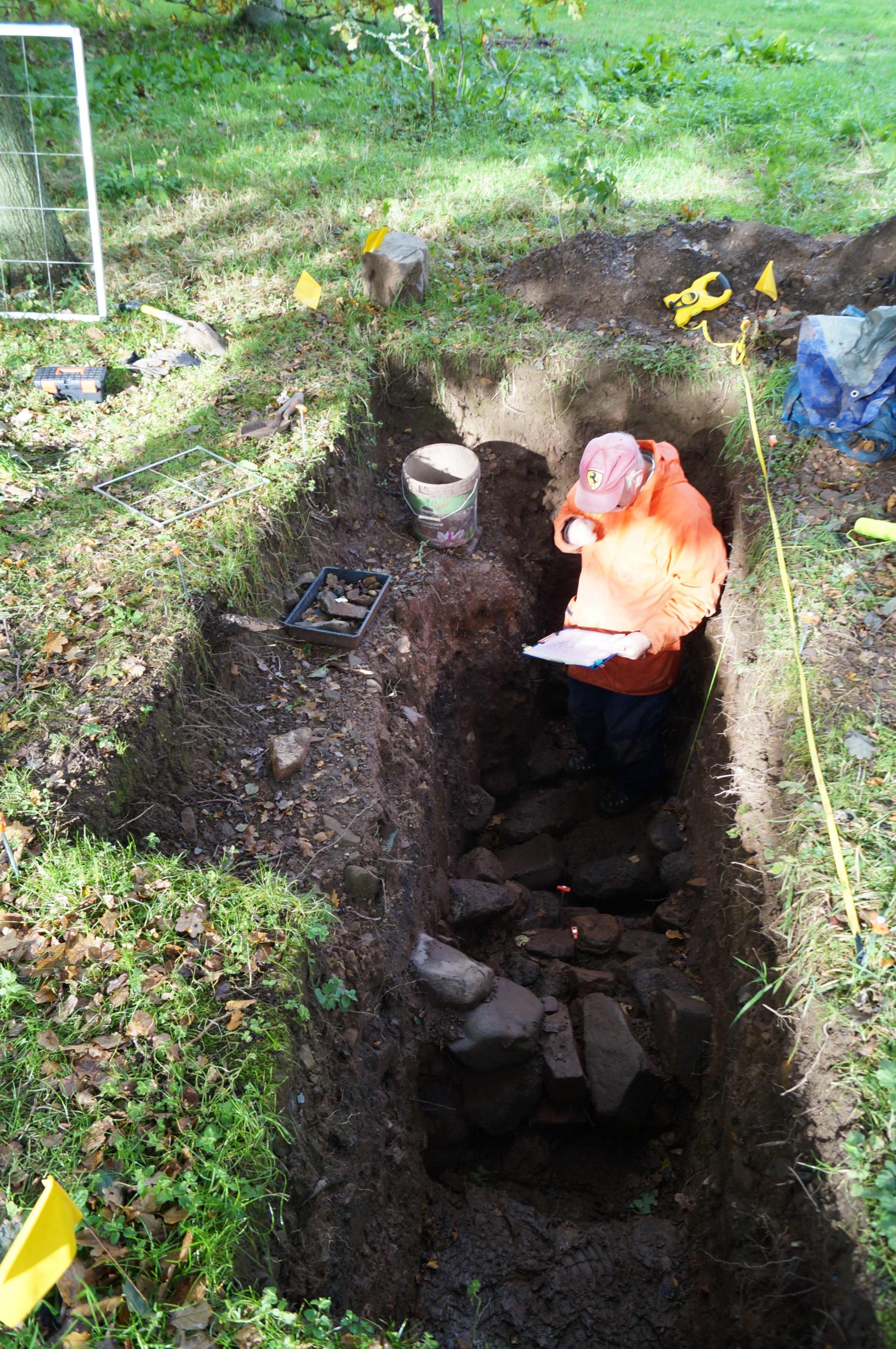
The GPR has suggested the extent of a hardcore platform that appears to have supported the ‘Old Tower’. This was thought to have been the earliest part of the castle but without hard evidence. We hope to test the presumed limit of this platform as we extend our trench southwards from the well that sat within the tower. (As you will recall, the GPR alerted us to that remarkable feature that became a focus for our 2019 season.) The GPR suggests that there may be a revetment supporting the platform at that point. Also, any relationship between this platform and the mid 12th-century kiln will be important in attempting to date that platform and, by extension, the Old Tower itself.

Well found in tower as a result of the GPR survey

The radargrams have also demonstrated the probable line of a terrace and sunken formal garden (red hachures on plan) and permits the excavated section of revetment and steps (shown in black) to be placed in its proper context. This garden probably dates to the 16th or 17th century, though exactly when is still debatable. The construction of the terrace removed all trace of the earlier (early to mid 15th century) ditch and so must post-date that. A late 17th-century Dutch pipe bowl found in the fill of a post hole associated with the steps suggests its removal at around that time or shortly thereafter. No trace of the terrace appears on the estate plans of c.1770.

The line of the defensive ditch has been shown by the radargrams to extend westwards from the excavated portion in Trench 11. This gives us an accurate alignment permitting its course to be drawn, even though the middle section was removed by the terrace. Where its return is at the western end of the site is still a mystery. The eastern arm was excavated in Trench 2 lying beneath the later (early 16th-century) lower courtyard. The 15th-century upper courtyard incorporated the tower with the surviving hall block (shown in blue). The courtyard’s west range can be estimated from remains found during the kiln excavation, but its eastern boundary was removed when the lower courtyard was added.

Finally, the GPR revealed the line of the outer enclosure wall as depicted on the estate plans. This was sampled in 2019 and the base of the wall found. The date of this feature is presently unknown and further work needs to be done to try to clarify that matter.

Evidence of landscaping material in outer enclosure copyright Iain Ralston

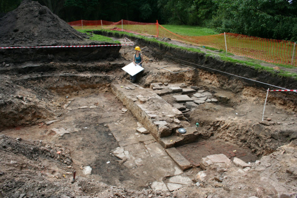
Sadly, work planned for 2020 included the extension of the ‘well trench’ in the car park to look for the possible revetment suggested by the GPR as well as opening a much bigger area across the outer enclosure wall, as located by GPR. This sits beneath a good metre and a half of later landscaping material (see picture, courtesy of Iain Ralston) and, for safety and archaeological reasons, demands a much larger trench. The keyhole sample trench indicates good survival and, it is hoped, evidence will be found to date the feature and to help explain when this became the northern boundary of the castle enclosure.

The excavated evidence together with the GPR results permit this developmental plan to be made and rough dates affixed. It is worth noting that, prior to our investigations, Druminnor was believed to have consisted solely of the surviving hall block with an attached tower at its western end. Everything not in blue on the plan, therefore, was formerly completely unknown.

Access in 2021 is still, sadly, in the laps of the Gods owing to Covid, but it is hoped that we will be able to get back on track later this year to look for more goodies!

Subscribe to our quarterly newsletter

Five New Awards and £100,000 in six years

We are excited to announce five grants totalling a record £27,000 that will advance our understanding of castles. These awards mean we have reached the landmark of giving away £100,000 in grants. It has taken six years for us to do that during which time the Trust has doubled the maximum amount we can award to £10,000.

Before you read about the five projects below, be sure to subscribe to our newsletter if you haven’t already.

  • Druminnor, Aberdeenshire – Using GPR for an investigation of the 15th century core of the castle – presently under a hardcore car park. This was the original caput of the lords of Forbes. During the 15th century they were amongst the most powerful families in the North-east of Scotland.
  • Hoghton Tower, Lancashire – This project aims to form an axis of research into Hoghton Tower’s unique physical history. The main focus will be to investigate and advance the knowledge of the pre-1560 site and specifically try to test the hypothesis that the north side building may form part of the ‘original’ Hoghton Tower.
  • Laughton en le Morthen, South Yorkshire – Excavation to try to confirm the findings of the geophysical surveys the CST funded in 2018. These indicated that the castle was placed right on the top of a high status Saxon dwelling.
  • Shrewsbury, Shropshire – Geophysical survey and excavation to determine how the castle buildings were laid out in the bailey. This will be the first time the well preserved motte-and-bailey castle has been excavated. First mentioned in 1069, Shrewsbury Castle was a key point along the Anglo-Welsh border and fell into ruin following the conquest of Wales.
  • Wressle, East Yorkshire – A geophysical survey of the area to the south of the castle ruins which had been covered by the previous earthwork survey funded by the CST, to get more information about the various garden structures there, as well as other details regarding the deserted village, moat and fishponds. The 14th century castle was one of the most important castles owned by the Earls of Northumberland.

Be sure to follow us on social media where we’ll be bringing you updates from the field, with work starting this month. In the meantime, here are some of our supporters discussing our work. we hope you’re looking forward to this year’s projects as much as we are!

The projects we’re considering for 2019

The deadline for grant applications passed on 30th November. We’re going through the various projects now. Altogether the 12 projects, coming from all parts of Britain and one from Ireland, are asking for over £75,000.* They cover not only a wide period of history but also a wide range of topics. In a little more detail, here are the applications we’ve received:

Collyweston, Northamptonshire

  • Contributing towards a community excavation at the early Tudor palace commissioned by Henry VII’s mother, Margaret Beaufort. According to building accounts the palace was built around three courtyards and was the first brick building in Northamptonshire. The palace was demolished in 1640 and the site has never been excavated before.

Druminnor, Aberdeenshire

[10] Druminnor Castle - "Woops!"
Using Ground Penetrating Radar for an investigation of the 15th-century core of the castle – presently under a hardcore car park. This was the original caput of the lords of Forbes. During the 15th century they were amongst the most powerful families in the North-east of Scotland.

Hoghton Tower, Lancashire

hoghton tower
This project aims to form an axis of research into Hoghton Tower’s unique physical history. The main focus will be to investigate and advance the knowledge of the pre-1560 site and specifically try to test the hypothesis that the north side building may form part of the ‘original’ Hoghton Tower.

Lathom, Lancashire

Excavation to establish the form and location of the southern perimeter of the curtain wall of the 15th-century castle known as the Northern Court of which nothing remains above ground from the period. It was one of the most important castles in the north west of England in the late 15th and 16th centuries. The castle was besieged twice in the English Civil War and then slighted. In 2017 we funded analysis of masonry recovered in earlier excavations, which indicated architectural links with Caernarfon Castle.

Laughton en le Morthen, South Yorkshire

Photo by Mike Neid

Following on from last year’s grant, this project would undertake excavation to investigate features identified during the geophysical survey. The survey suggested that the castle was built over an Anglo-Saxon lordly residence, and the excavation would test whether there is further evidence to corroborate this.

Lewes, East Sussex

Photo by Richard Gailey, licensed CC-BY 2.0.

This research aims to answer an intriguing question: why does Lewes Castle, East Sussex, have two mottes? Do they represent a highly distinctive architectural statement, or did burial mounds of possible Romano-British or earlier origins influence the form of the 11th century fortification?

Loughmoe, County Tipperary

Castles of Munster, Loughmoe, Tipperary - geograph.org.uk - 1542634
To produce the first-ever detailed survey and structural history of the building which dates from the 15th and 16th centuries, and to determine using geophysics the extent of the original castle and whether the renaissance part had a precinct, other buildings, and gardens.

Raglan, Monmouthshire

Photo © Jeremy Cunnington

Using inferences from previous geophysical surveys to focus on key areas of the lower terraces and bowling green of the castle potentially revealing more about the clandestine political activity of the Somerset family in the late 16th and 17 centuries.

Shrewsbury, Shropshire

Shrewsbury Castle looking West
Geophysical survey and excavation concentrating on the inner bailey to in particular examine the tail of the north rampart. Despite being one of the main fortresses on the Welsh border no major excavations have taken place in the bailey. Thus the medieval plan of the enclosure, and the missing domestic ranges that should be there, are completely unknown.

Snodhill, Herefordshire

Photo © Jeremy Cunnington

Excavations in this important Welsh border fortress that was in use from just after the conquest to the English Civil War. The aim is to answer some key questions about the castle e.g. the keep’s entrance and final form, to establish the form of the North Tower and along the south side to see if that was where the entrance was.

Tarbert, Argyll

East Loch Tarbert and Tarbert Castle - geograph.org.uk - 1624617
Funding post-excavation costs of a community archaeology project. The project will be trying to see discover a number of things about this royal castle including if there was a southern entrance into the outer bailey, and what buildings there were along the north east range of the inner bailey.

Wressle, East Yorkshire

A geophysical survey of the area to the south of the castle ruins which had been covered by the previous earthwork survey funded by the CST, to get more information about the various garden structures there, as well as other details regarding the deserted village, moat and fishponds. The 14th century castle was one of the most important castles owned by the Dukes of Northumberland.

The applications have been sent to our expert assessors who will go over them. You can see how the assessment process works from our blog back in January 2016. And don’t forget to subscribe to our newsletter.

*The article was updated at 15:28, 10th December to remove Halton Castle.