Recent discoveries at Shrewsbury Castle

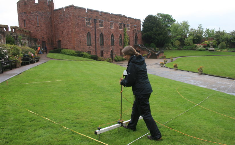
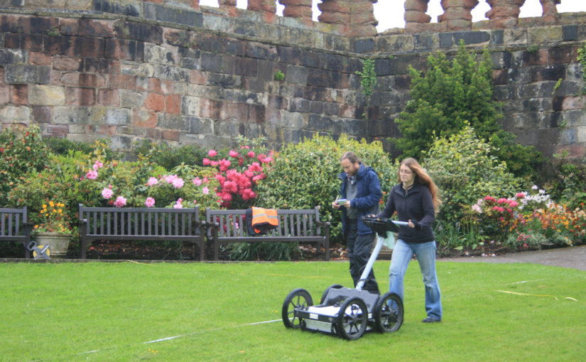
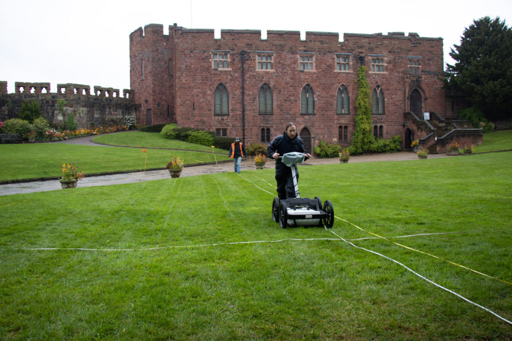
With the 2020 excavation report now published, Shrewsbury Castle Excavation Director Dr Nigel Baker looks back at the two years of excavations and what they reveal about this important castle of the Welsh Marches.

Before the excavations in 2019 and 2020 funded by the Castle Studies Trust, Shrewsbury Castle was one of the least well understood major castles of the Welsh Marches. Its visible form is that of a classic motte-and-bailey, with earthen ramparts surmounted by stone curtain walls. However, the archaeological project and associated research has shown that the historical reality is more complex than this.

Subscribe to our quarterly newsletter

First recorded as a consequence of being besieged by local rebels in 1069, many aspects of its recorded history follow a familiar Marches pattern: heavy royal expenditure in the 12th and 13th centuries as a campaign base and in the face of Welsh raiding, followed by decline into obsolescence and ruination in the 14th, 15th and 16th centuries, arrested temporarily by a return to active service in the English Civil War in the 1640s. Its later history was as a private residence, distinguished by its ‘restoration’ by Thomas Telford in 1786-1790, and finally its return to public life as a council meeting hall in 1925 and as the home of a regimental museum in the 1980s.

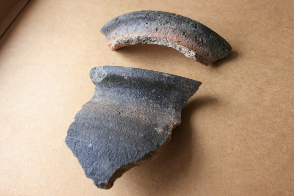
First of all, the Norman castle was not built on an empty site. It occupied the end of a ridge that was critical to the defence of the old Saxon borough, and the 2019 excavation demonstrated occupation here in the 10th or early 11th century, on a plateau or low knoll at about 68m AOD, higher than its surroundings, and at one end of the likely cross-peninsula borough defences. At present the archaeological evidence is limited to a single pit and its artefacts, but reading between the lines of the historical record, it is possible that the site was shared by a church dedicated to St Michael and perhaps a hall, maybe that of the pre-Conquest sheriffs.

Plan of Shewsbury Castle as it may have appeared in late 11th / early 12th century copyright Dr Nigel Baker. The black lines indicates probable masonry curtain wall lines, based on the presence of the ‘green slabby rubble’ masonry that appears at various junctures at the bottom of some elevations and seems to be early, meaning potentially pre-13th

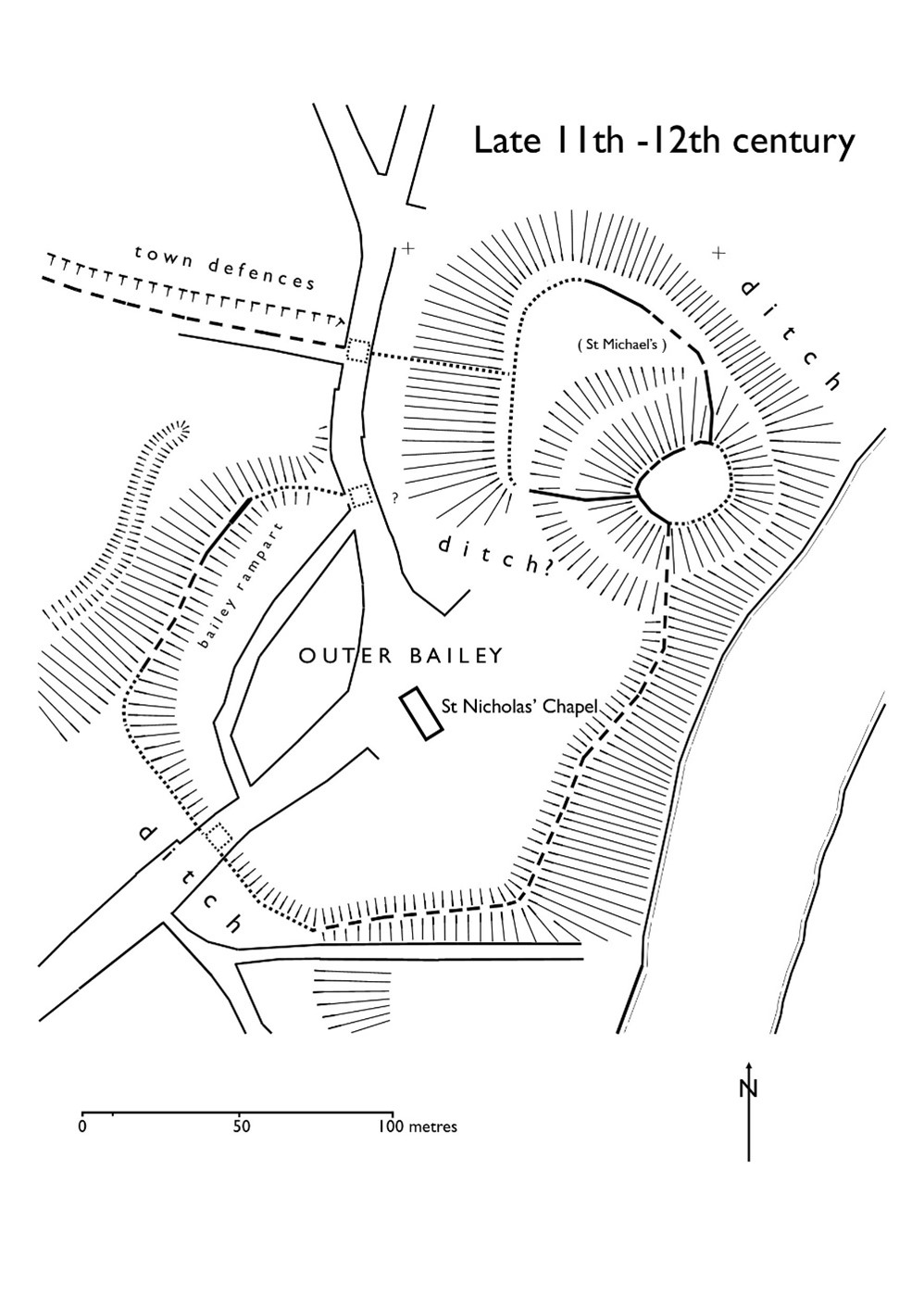
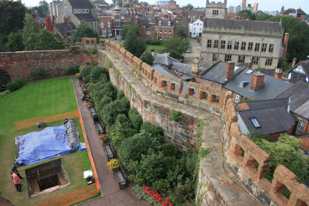
The Norman castle of the 1060s wiped out all that had been there before, except the church, which appears in Domesday Book; this also records the loss of 51 tax-paying households when the castle was built. It consisted of a large motte overlooking the river, elevated to a height (80m AOD) equal to that of the royal and episcopal halls within the old borough, with a substantial ditch, discovered in 2019, around its base. West of the motte was a small inner bailey. Extending south was a much larger outer bailey, separated from the English borough further south by a second cross-peninsula ditch and supplemented in the 12th century by earth ramparts around the bailey perimeter. The small size of the inner bailey, in reality perhaps more of a barbican, suggests that the royal hall, documented from 1246 but probably present from the beginning, was on the motte top.

It is not yet clear when the earth and timber defences began to be replaced in stone, but stretches of thin, slabby rubble in the curtain walls and motte wing walls may be indicative of work in the late 12th or early 13th century.

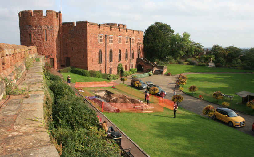
Major changes took place throughout the 13th century, some documented, some suggested by the excavations. The single surviving medieval building, often called the hall, is fairly certainly the camera regis or royal chamber built in 1239-41, a date consistent with the dendrochronological evidence from the building. It may have been constructed as part of a larger rebuilding campaign that saw the west side of the inner bailey expanded westwards by pushing a terrace out over the gradient behind a newly-built ashlar curtain wall. This is one of the conclusions of the 2020 excavation trench through the western rampart, which found medieval tipped strata at a level below that of the natural gravel seen in the interior of the bailey in 2019.

Plan of Shrewsbury Castle in late C13. Copyright Dr Nigel Baker

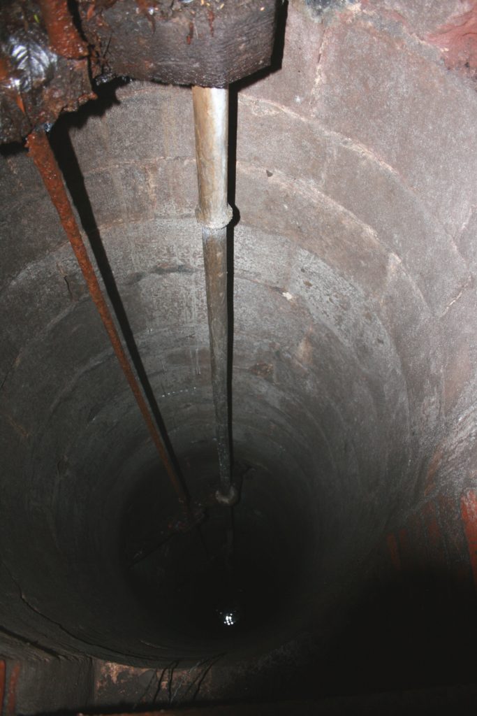
Meanwhile, the east side of the motte was subject to erosion by the River Severn and the consequent partial collapse of the motte was recorded by an enquiry held in 1255; in 1269-71 a ‘great wooden tower’ fell down and was said to be totally destroyed. The motte top was repaired towards the end of the 13th century with a new wall built across the damaged side in red and white striped masonry. The motte ditch appears to have been infilled, mainly by the deposition of rubbish, and a new castle well, which survives, was dug within it.

As the town grew, the outer bailey was built over. In 1220-c.1250 when the town walls were built, the outer bailey was walled continuously with the rest of the town and no longer separated from it; the tenements that had been established there continued to pay their ground rents to the crown while those outside, further south, paid theirs to the borough.

Two early plans show what had become of the castle by the end of the 16th century. The Burghley Map of Shrewsbury of c.1575 shows the main building unroofed, a smaller building (perhaps St Michael’s) in ruins, and just one roofed building standing in the inner bailey in the area of the surviving well. A sketch plan by the master mason John Smythson of 1627 likewise shows the main building, and most of the curtain walls, in a ruined condition; it also shows a gatehouse of which there is no other evidence.

Restoration came in 1643-44 when the castle was garrisoned by the Royalists, and the borough’s mayoral accounts record expenditure on the main gate and its new barbican, a new postern gate, walls and outworks. The castle was captured for Parliament in February 1645; what appears to be battle-damage can be seen on the woodwork of the main gate and around the openings of the main building but this identification now needs confirmation by battlefield archaeologists. After its capture, the Parliamentarians continued the Royalists’ restoration of the main building, its roof and gallery built with timber felled in the winter of 1647. The castle was finally de-munitioned in 1686 and became a private residence.

Shrewsbury Castle in 18th Century, note on the wall on top of the motte the possible base of windows of a high status building / Great Hall.

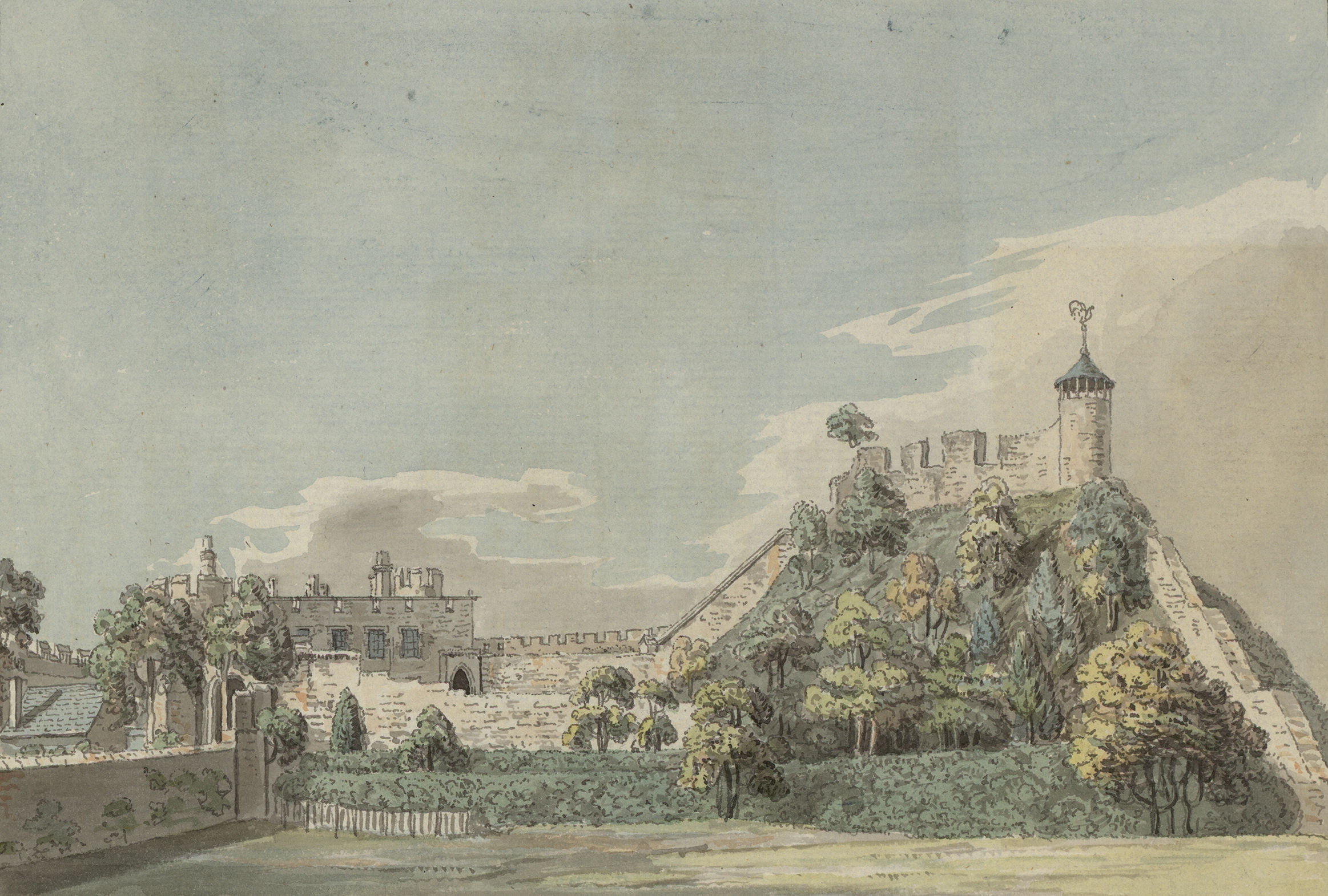
Thomas Telford’s ‘restoration’ of the castle in 1786-1790 for Sir William Pulteney was nothing if not brutal. The excavations in the inner bailey have shown that the interior was levelled down, scraped bare, and at least some of the material used to enhance or even create the ‘ramparts’ around the perimeter. Illustrations show that, until 1786, the motte top was still occupied by a 13th-century round tower and the ruins of other, as yet unidentified, buildings. These were all swept away and replaced by Telford’s ‘Laura’s Tower’, a fine, two-storey summerhouse in the Gothick style.

Subscribe to our quarterly newsletter

Shrewsbury Castle – more than meets the eye

Shrewsbury Castle Excavation Director, Dr Nigel Baker, reviews the second season of excavations at the castle which has just ended, with an unexpected conclusion.

Shrewsbury Castle has sometimes been described (most often by the writer of this blog!) as one of the best-preserved shire town motte-and-bailey castles in the west of England. This remains true – at least in the sense that it has never been quarried away for gravel, nor had a prison or law courts built on top of it, nor was it demolished and redeveloped after the Civil War. Nevertheless, such a statement now requires a hefty footnote.

Subscribe to our quarterly newsletter

A visitor, walking into the inner bailey at the foot of the motte sees crenelated curtain walls rising from the top of substantial ramparts: the impression of a classic castle sequence with earth-and-timber fortifications renewed in stone, is overwhelming. The 2020 work has however shown that neither the ramparts nor the western curtain walls are quite what they seem. Excavation to a depth of more than two metres in the western rampart has shown that at least half of its height was a product of the post-medieval centuries – with a substantial contribution probably made by Thomas Telford during his ‘restoration’ of the castle in 1786-90, enhanced by his simultaneous lowering of the ground level across the interior.

Shrewsbury Castle excavation trench in western rampartas viewed fromfrom C13 logis block. Courtesy of Nigel Baker

But the medieval strata below Telford’s rubble also show that the western curtain wall, and by implication the standing castle building, the camera regis of the later 1230s, can no longer be seen as simple improvements to the original earthwork castle as the ground beneath them was found to drop away sharply, the slope levelled up by a massive medieval earthmoving operation. It seems that the present outline of the castle – and the familiar view of it from the railway station below, are a product of the early 13th century (dating subject to confirmation when the pottery has been analysed) – dubbed Shrewsbury Castle 2 by the excavators. The ‘original’ motte-and-bailey, first heard of when it resisted a siege in 1069, must have had a perimeter that was around 25% smaller, confined to the original hilltop. This castle (inevitably ‘Shrewsbury Castle 1’) was nevertheless heavily fortified, as the substantial motte ditch found in 2019 shows. As originally conceived, the ‘inner bailey’ was little more than a lobe-shaped barbican, protecting access up onto the motte, with little room for buildings within it. One of the implications of this is that the most important buildings – like the royal hall – must have been on the motte top.

The medieval landfill operation is also of interest on account of the rubbish contained in its strata. Preliminary visual identification of the animal bones suggests that game species are present, possibly pike, possibly swan, and it is likely that further work on this material will add to the growing corpus of evidence for high-status diet on castle sites throughout the region.

Subscribe to our quarterly newsletter

The excavation was funded by the Castle Studies Trust and supported by University Centre Shrewsbury under Professor Tim Jenkins and Dr Morn Capper. Archaeological direction was by Dr Nigel Baker and Dai Williams and the work was undertaken by local volunteers and UCS postgraduates and undergraduates.

Feature image courtesy of Dr Nigel Baker

Shrewsbury Castle: a 2020 vision, from Saxon habitation to C18 landscaping?

Project lead for the Shrewsbury Castle excavations Dr Nigel Baker looks forward to the forthcoming excavations at the castle, hopefully this year, funded by the CST

Last year, the Castle Studies Trust excavation – the first ever to have taken place within the walls of Shrewsbury Castle – produced three headline conclusions. The first was that the work of the young Thomas Telford there for his client, William Pountney M.P. in 1786-90 was, sadly, more destructive of the medieval original than had previously been recognised. The extent of his restoration of the house (now the Soldiers of Shropshire Museum) and the curtain walls has long been known. What wasn’t appreciated was that standing walls of ruined buildings and a 13th-century tower on the motte top were destroyed and reduced to their footings, and the interior of the inner bailey was, it seems, scraped flat, producing a lovely level lawn at the expense of any archaeological deposits overlying the natural gravel of the hilltop. Despite this, infilled negative features (pits and ditches) cut into the gravel survived and were found by our excavation trench. As a result, our second headline conclusion was that the motte was ringed on its landward side by a massive ditch, twelve metres wide: what we know as the inner bailey must, in the early Middle Ages, have been little more than a barbican defending the end of the bridge giving access up the motte.

C18 Remodelling?

But the extent of Telford’s work raises a question, first put to the archaeological team by Martin Roseveare, our geophysicist: if Telford had the inner bailey levelled flat, where did he put the proceeds, meaning the scraped-up earth and debris? Could the apparently well-preserved medieval ramparts ringing the bailey actually be down to the young Scottish civil engineer, rather than impressed English labour under the whip-hand of William the Conqueror’s henchmen? This is one of the leading questions that a second season of excavation at Shrewsbury Castle hopes to be able to answer, by digging on part of the western rampart known to be already disturbed by former Victorian greenhouses.

High Status Saxon Living

There are, however, other at least equally compelling reasons for excavating on this site. The third headline conclusion of the 2019 trench was that there was pre-Conquest activity within the area of the inner bailey. This was demonstrated by a pit, pit 20, containing Stafford-type ware (well known in late pre-Conquest Shrewsbury) and a type of pottery known as TF41a, an import up the Severn from Gloucester, never seen before in Shrewsbury. The question is, what was it doing there?

Top piece Rim of type 41a Saxon pottery from Gloucester
Lower piece: Rim of Stafford ware Saxon pottery

Shrewsbury is one of those castles listed in Domesday along with the destruction it caused to its ‘host’ shire town. Construction of Shrewsbury Castle took out 51 tax-paying tenements, a quarter or a fifth of the total built-up area, to the economic distress of the remaining inhabitants. Many of the destroyed plots will have lined the strategically important Chester to Hereford road that passes through the outer bailey. However, looming over the road and its plots, and the main gate through the pre-Conquest defences, was the hilltop on which the castle would come to be built. And on it, overlooking the gate, most likely on the Victorian greenhouse site, was the Church of St Michael, a church that became the castle chapel, but was listed in Domesday between the entries for two of the town’s pre-Conquest minsters and was served by two priests later in the Middle Ages, when it was a royal peculiar, exempt from episcopal oversight. This need not necessarily all add up to a pre-Conquest church – but the chances are very strong that it does, and that this church, which, overlooking the town defences,  may have had some kind of defensive role, was part of the context of pit 20.

Subscribe to our quarterly newsletter

The clues are beginning to point to a high-status site, probably enclosed, with its interior ground level two metres above that of its neighbours, and its own church. For an analogy, one could do worse than look to Wallingford, whose castle in the north-east corner of the Saxon burh had probably taken over and re-fortified a royal site of some kind, possibly housing government functions, perhaps a mint, and a garrison of housecarls. Or one might look to Oxford, where St George’s Tower is now generally thought to be of pre-Conquest date. Shrewsbury seems to be joining the list of Norman town castles established on sites of political, not just tactical, importance.

But archaeology can be frustrating. While we hope that excavation of the Victorian greenhouse site in the west rampart may yield insights into the extent of Thomas Telford’s landscape gardening, the foundations of a pre-Conquest church and further clues to a high-status or even royal site preceding the castle, by 2021 the excavation team may well be singularly well-informed experts on…Victorian greenhouses.

Subscribe to our quarterly newsletter

Exploring Shrewsbury Castle

This year we’re funding investigations at Shrewsbury Castle, one of the most important castles along the Anglo-Welsh border. Nigel Baker told us how the work has been going.

Phase 1 of the Castle Studies Trust’s Shrewsbury Castle 2019 project is underway. Archaeological research is a long and painstaking process, so instant results are not to be expected – it must have taken a whole three hours to establish for the first time a number of simple but really fundamental facts about the hitherto-unexplored inner bailey.

Work started on Wednesday 8th May with the arrival at the castle of Tiger Geo, specialist geophysical survey contractors. Using ground-penetrating radar and resistivity, the lawns of the inner bailey interior and the slopes of the ramparts were gridded out and surveyed; the geophysicists never stopped, nor did the rain. But two basic conclusions emerged on screen from the raw data.

Tiger Geo doing sterling work despite the weather.

The first is that a ditch did once encircle the base of the motte within the perimeter of the inner bailey. This implies that the flat area within the inner bailey must originally have been a crescent-shaped area less than twenty metres wide from motte ditch to rampart tail.

The second conclusion is that there is, under the grass opposite and parallel to the standing early 13th-century ‘Great Hall’ (which houses a very fine Regimental Museum), another big building range backing onto the motte ditch. Given that the standing first-floor Great Hall was built as a royal chamber block (‘camera’) in the 1230s-40s, there is a possibility that a real Great Hall awaits excavation in the summer. But we’ve already answered one of the project’s main questions, ‘how was the inner bailey planned?’ The answer is there were two main ranges of buildings and no room for anything else.

While Tiger Geo mowed the lawns, the writer was busy in a bush at the base of the motte, freeing-up a manhole cover sealed for a decade. Under, a 20th-century brick inspection chamber gives access to a stone well-shaft alongside. The writer had been shown it surreptitiously by a kind gardener in the 1990s but without the opportunity for much recording. Now it has been photographed (though not with stunning competence), measured at just over seventy feet deep from ground level down to water level, and the masonry identified as probably late medieval – and not something done by Thomas Telford in the 1790s. So – Shrewsbury Castle retains its medieval well.

The medieval well. It’s a dizzying 21m down to water level.

To stay up-to-date with our work, subscribe to our newsletter.