Commemorating Bedford Castle on the 800th anniversary of the great siege of 1224

On Saturday, 24 August, the Higgins Museum in Bedford hosts an event to mark eight centuries since the town’s castle was subject to an 8-week long siege by the army of the teenage King Henry III (booking details at the end). Dr Peter Purton, FSA, outlines what happened in the siege.

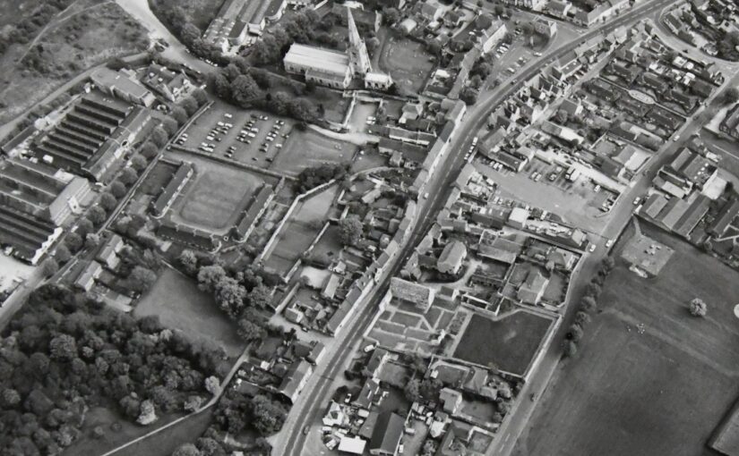
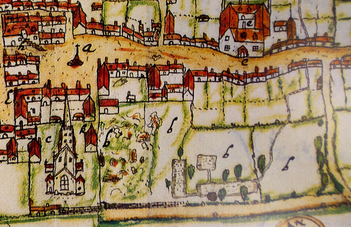
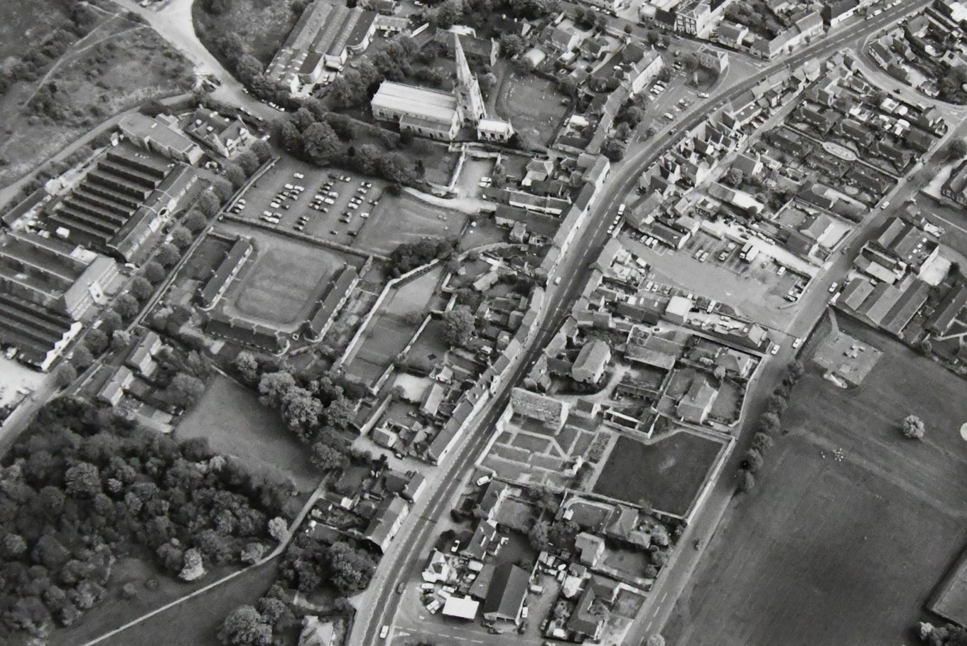
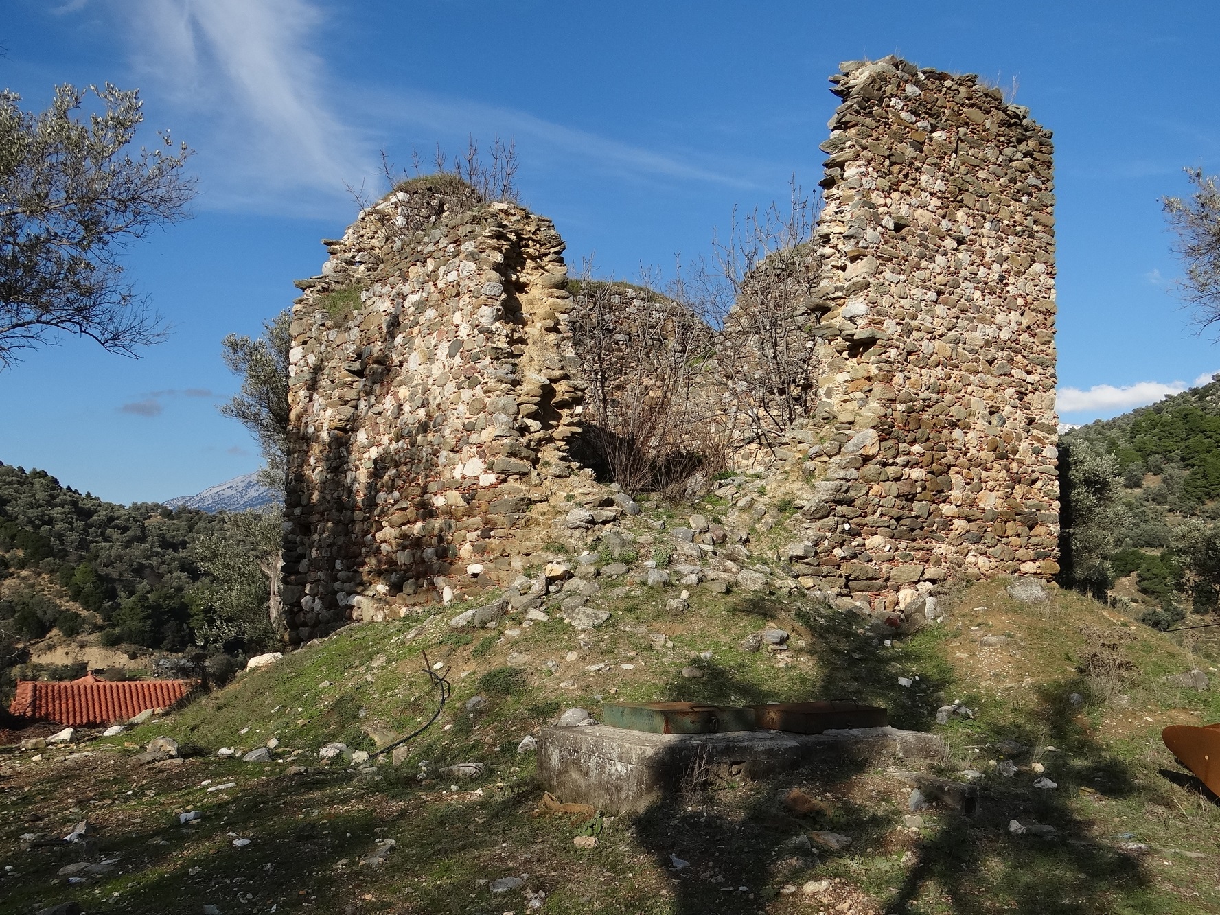
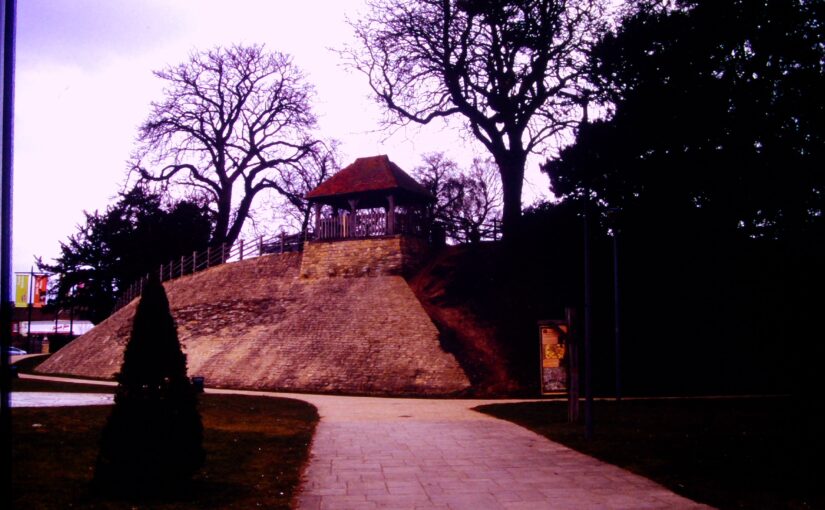
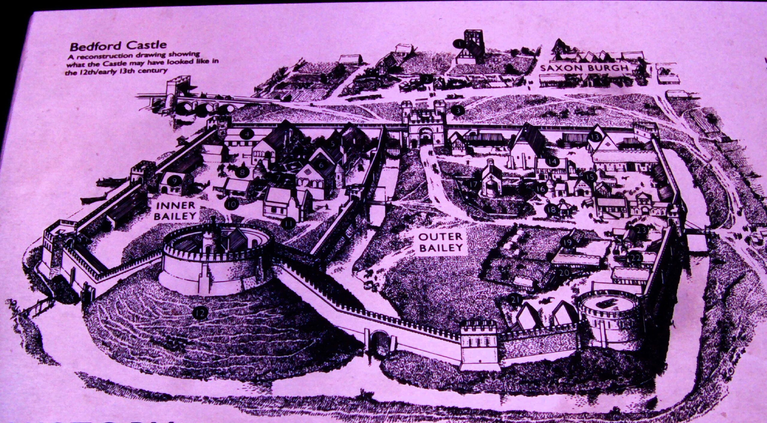
Not much remains now of Bedford Castle – just a degraded and much altered mound near the river Great Ouse in the town centre and a few excavated fragments of stone buildings, making it hard to visualise that it was once a large stone-built fortress with a moat, barbican, two wards and a stone tower on top of the motte which marked the original castle built after the Norman Conquest. A display board nearby reconstructs its possible appearance in 1224.

Subscribe to our quarterly newsletter

Image of display board showing how Bedford might have looked in 1224

 In that year, Henry III was assembling an army which was to be transported to France in an attempt to recover Poitou, part of the once extensive Angevin empire. This plan unravelled with the rebellion of Fawkes de Breauté. Fawkes had been one of the captains of King John, Henry’s father, and had become rich and powerful. He had been granted Bedford castle and we are told that he had strengthened the fortifications to make it “impregnable”. Rebelling against the crown, he prudently left the country while leaving Bedford in the hands of his brother, who in arresting the justices sent there by the king made it inevitable that he would face royal retribution: this was a direct insult to royal authority and following years of civil war and rebellion following John’s reign, there was no possibility that it could be ignored. The royal army, assembling conveniently nearby at Northampton, was diverted to Bedford. What happened next was recorded in several contemporary chronicles while royal expenditure was detailed in surviving accounts, a combination of evidence which is rare enough and which allows an unusually detailed reconstruction of the siege.

The royal army deployed seven stone-throwing engines (mangonels and petraries) and built two siege towers but the garrison resisted stoutly and inflicted heavy casualties on the attackers. Eventually the barbican and outer ward were breached and captured by royal soldiers then miners, summoned from the Forest of Dean, brought down the wall of the inner bailey and did the same with the tower on the motte, to which the defenders had withdrawn. The prisoners were set free and the entire garrison was hanged as punishment for their rebellion. The castle was then demolished.  A period of instability in England was thereby ended, but so too was English rule in Poitou, the French capturing La Rochelle at the same time as Bedford was being besieged.

These events were therefore of international as well as national significance, and through archaeology, it is possible to now know much more about Bedford castle. All these themes will be discussed at the conference on 24 August, the speakers are Professor David Carpenter, expert and author specialising in this period, Dr James Petre who has written about Bedford, Ben Murtagh who has been exploring Bedford Castle, Jeremy Oetgen (Albion Archaeology) who will update us on a long history of archaeology on the site, and the author of this blog who will place the siege in the context of contemporary siege warfare.

Anyone interested in attending can find all the details and book a ticket at the museum website: www.thehigginsbedford.org.uk. Tickets cost £15 and advance booking is encouraged.

Subscribe to our quarterly newsletter

Higham Ferrers – a Royal Town

Project lead, Steve Parry, looks at what he and the team from MoLA and the Higham Ferrers Archaeology and Research Society hope to achieve during their geophysical survey of the once royal castle of Higham Ferrers starting on Monday 15 July 2024.

Walking through the streets of Higham Ferrers you’d be forgiven for thinking that you are looking at a pretty but provincial town.  However, documentary records reveal that Higham Ferrers once played a role on the national stage. During the Middle Ages it had a substantial stone-built castle which served as the headquarters of the extensive Northamptonshire landholdings of the Duchy of Lancaster and from 1399, became a possession of the Crown.  This castle, which was also the manor, would have been the focal point of the medieval town along with other fine nearby buildings including the Church of St Mary, the School House, the Bede House or hospital and the College founded by Henry Chichele, Archbishop of Canterbury before 1425. While these other buildings have survived to the present day the castle fell into disuse and was demolished in the early sixteenth century, with Henry VIII granting building materials from the site for the rebuilding of Kimbolton Castle. John Norden’s map of 1591 shows the site of the castle (‘b’) as broken masonry and uneven ground adjacent to the church, and all that now remains are a ruined dovecote, fishponds, and rabbit warren.

Subscribe to our quarterly newsletter

A detail of John Norden’s Map of Higham Ferrers 1591

Thanks to a generous grant from the Castle Studies Trust, Museum of London Archaeology (MOLA), will work with Finham Heritage and members of the Higham Ferrers Archaeology and Research Society (HiFARS) to reveal Higham Ferrers’ royal connections through a series of geophysical surveys. We will use a magnetometer to identify any substantial ditches around the castle, as well as the buried remains of internal features such as robbed-out walls, hearths, and pits.  Alongside this, the team will use ground penetrating radar to locate the principal buildings of the castle confirming (or denying!) what our documentary sources tell us – that this substantial medieval building included a hall, chapel, tower house, King’s and Queen’s Chambers, not forgetting three substantial gates. Finally, a resistivity survey will be undertaken, with the particular support of HiFARS members, to provide further detailed information on any buried wall foundations or other structural remains.  The surveys will be undertaken in the various plots shown in this photograph from the 1980s extending from the church (top centre) to the small wood (bottom left-hand corner).

Aerial photograph of Higham Ferrers NCC9668_004
Reproduced by permission of Northamptonshire HER

Together with the documentary sources, the geophysical surveys will, we hope, shed light on the evolution of the site by:

  • Seeking evidence of a late Saxon and early medieval manor pre-dating the construction of the castle.
  • Testing the widespread assumption that a motte and bailey castle was built by William Peveril, who held the manor in 1086.
  • Attempting to map the layout of the late medieval stone castle.

The findings of the surveys will be considered alongside those of limited excavations in 1992, to see how the castle and its associated buildings fit within the development of Higham Ferrers from a Saxon administrative centre to medieval market town. The results and conclusions will be shared via a public lecture and published as a report on the Castle Studies Trust website.

Subscribe to our quarterly newsletter

The Fourth Crusade: new evidence challenges long-held opinions

The final results are in and Dr Andrew Blackler, project lead for the Dating of the Towers of Chalkida, Greece, reveals the surprising findings of the project we funded in 2022 to try and date the hundreds of towers in the region.

In the autumn of 1204 forces of the Fourth Crusade, fresh from their capture of Constantinople, annexed central Greece. Studies have been undertaken of the major fortifications they constructed, but little is known about the hundreds of towers, which are today a ubiquitous reminder to the modern tourist of the medieval period in the region.

Subscribe to our quarterly newsletter

The traditional interpretation is that they were built by the incoming westerners- the minor nobility – as part of a process of colonisation, to display and impose their power over the local Greek population. Yet, since no scientific study has ever been undertaken, we could not even be sure when they were built, and therefore why they were constructed or by whom – until now.

Figure 1: Map of Central Greece with Survey area on the island of Evia (Euboea)
 and the towers sampled (inset)

Following a two-year research program, funded by the Castle Studies Trust and led by Andrew Blackler, a member of the five-year ‘Hinterland of Medieval Chalkida’ survey, surviving towers in central Greece have now been dated using modern laboratory techniques. In October 2022 a team, including technical staff from the Institute of Nanoscience and Nanotechnology ‘Demokritos’ in Athens and from the Ephorate of Antiquities in Chalkida, took samples of wood and mortar from seven surviving towers on the island of Evia (Euboea). This is the second largest in Greece and runs two hundred kilometres down its eastern seaboard. The island, just seventy kilometres north of Athens, is separated from the mainland by a narrow strait only thirty-nine metres wide, the tidal flows of which even Aristotle failed to solve! Chalkida, its capital, became the Venetian administrative centre (as Negroponte) of its Aegean possessions in 1390 and, following its capture by the Ottomans in 1470, their capital of Central Greece for 350 years until the formation of the modern Greek state.

Figure 2. The ruins of a typical tower (Mistros)image description

All of the towers (walls about 8 x 8 metres and height up to 18 metres) were in an advanced stage of collapse. Samples were taken of the wood inserted to provide internal lateral structural integrity to their walls, and of the mortar used to bind their rough stonework. This ensured that these materials were not part of a more recent repair or renovation, which would have been the case for beams used to support the multiple floors of the towers, but part of the original construction phase. The ten timber samples obtained were then subjected to a process of radiocarbon (14C) dating, whilst the mortar was analysed using optical and scanning electron microscopy (SEM) and other techniques (pXRF and XRD) at the Demokritos laboratory.

Subscribe to our quarterly newsletter

The results have been exceptional. Six towers from different topographic locations (coastal, floodplain, mountain areas) have been dated with 95% certainty to a period between 1270 and 1434. Unfortunately, the accuracy for most samples was only approximately +/- fifty years due to fluctuations in the cosmic concentration of 14C in the earth’s atmosphere caused by solar activity during the fourteenth century: there were therefore two possible dating ranges identified. Two samples were of sufficient quality that, using what is known as ‘wiggle’ analysis, more accurate dating was obtained.

Figure 3. An example of one sample showing the wiggle in the calibration curve, that causes widening of the calibrated ages and splitting of the ranges.

The analysis of the mortar samples also demonstrated that two towers had two phases of construction. It is difficult to know whether this was a deliberate action or simply a reconstruction due to the collapse of the upper levels, given that the region is subject to frequent seismic activity. More importantly, since we could not identify any timber samples for one tower, it was possible to show that the chemical composition of this tower’s mortar was similar to two other towers in its immediate vicinity and thus was possibly also constructed in the fourteenth century.

The general conclusion, therefore, is that all the towers studied were probably built at least a century, or five generations, after the annexation of the region by western forces, and no towers were built immediately after the Crusaders took control. The ’colonial’ interpretation of their role is thus overturned or, at the least, requires reconsideration. Rather, their construction appears to have been a reaction by landowners to increasing instability in the region following invasion of the island by Byzantine forces in the 1270’s, the threat of attack by the mercenary Catalan Company who took control of Thebes and Athens in 1311, and a growing fear of seaborne assault by Turkish corsairs in the fourteenth century.

Subscribe to our quarterly newsletter