By Dig Director, Jim Brightman of Solstice Archaeology
Things are moving apace despite the sweltering conditions this week. We are now three days into the excavation, and all three trenches currently open have yielded up a variety of medieval pottery sherds as well as plenty of more recent artefacts.
Given the anticipated depths of some of the remains we are looking for, the last two days have seen a concerted flurry of digging to get through the topsoil and 20th-century overburden, particularly in Trenches 2 and 3. Once again the volunteers have excelled themselves and maintained a wonderfully positive attitude—whether debating the merits of marmalade and boiled egg toasties (apparently it’s a thing) or trying to convince the trench supervisors that they’ve found a Roman road (it wasn’t, but a good effort nevertheless).
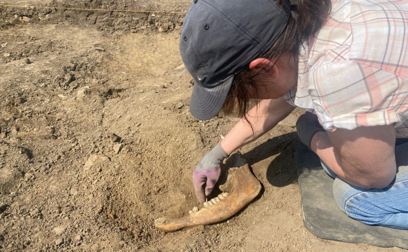
Jaw of Horse
Perhaps the most excitement that was generated among visitors to the Castle, however, was the discovery of a largely complete jawbone from a horse! Although it was a little too high in the deposits to be evidence for medieval stables (or a meal!), it was a real reminder to everyone that as we’re digging ever deeper, we never truly know what we are going to find.
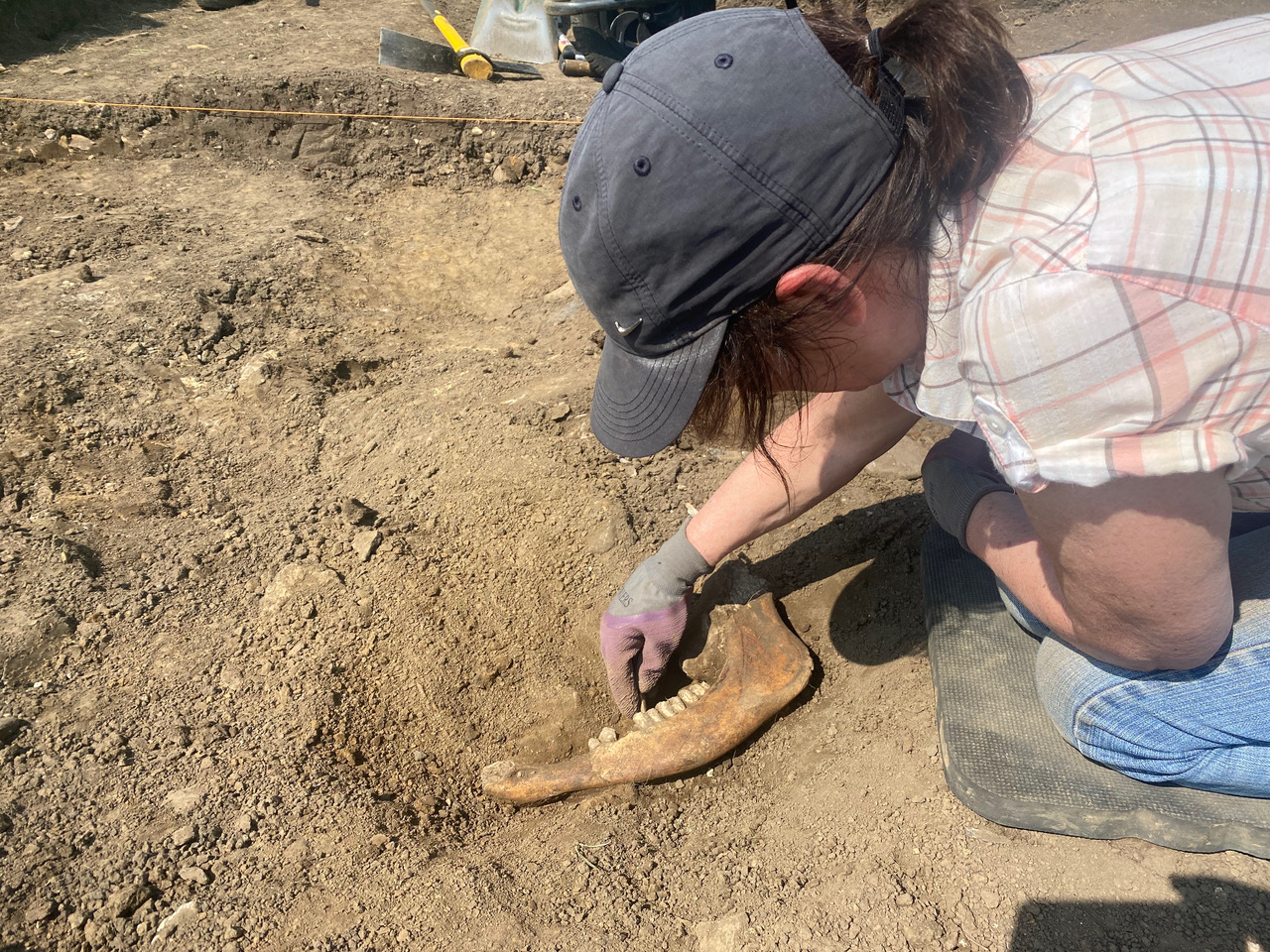
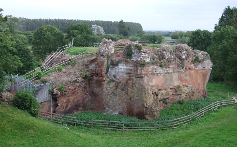
From the point of view of our main aims for the excavation, the biggest news of the day is that we starting to see the hints of probably medieval walling in both Trenches 1 and 2. Trench 1 by Robin Hood Tower is butted against the standing walls of the castle, but a lot of the stonework in this area was rebuilt and consolidated by the Ministry of Works in the 20th century. What we are seeing here are the first signs of original medieval stones beneath the surface—very exciting!
Possible remains of a medieval wall
Trench 2, however, was targeted to find part of a range of buildings never before known and revealed through geophysical survey. As the sun started to dip at the end of the day, and as we were starting to think about packing up the tools, loose rock started to turn up through the centre of the trench. A little more careful trowelling by the team soon revealed what may be the rubble core of a wall—our first window back into this untouched medieval structure.
By Dig Director Jim Brightman of Solstice Archaeology
Although my plan with these posts was only to provide updates of juicy finds and exciting discoveries, I really wanted to just put pen to paper (so to speak) on the evening of the first day on site. It has been an absolute scorcher, which was not ideal for the back-breaking labour of de-turfing, but the project volunteers have been fantastic!
We removed all the turf in the two largest trenches we are planning on excavating: the east ‘entrance’ by Robin Hood Tower and the confluence of wall foundations near the Great Chamber revealed through geophysical survey.
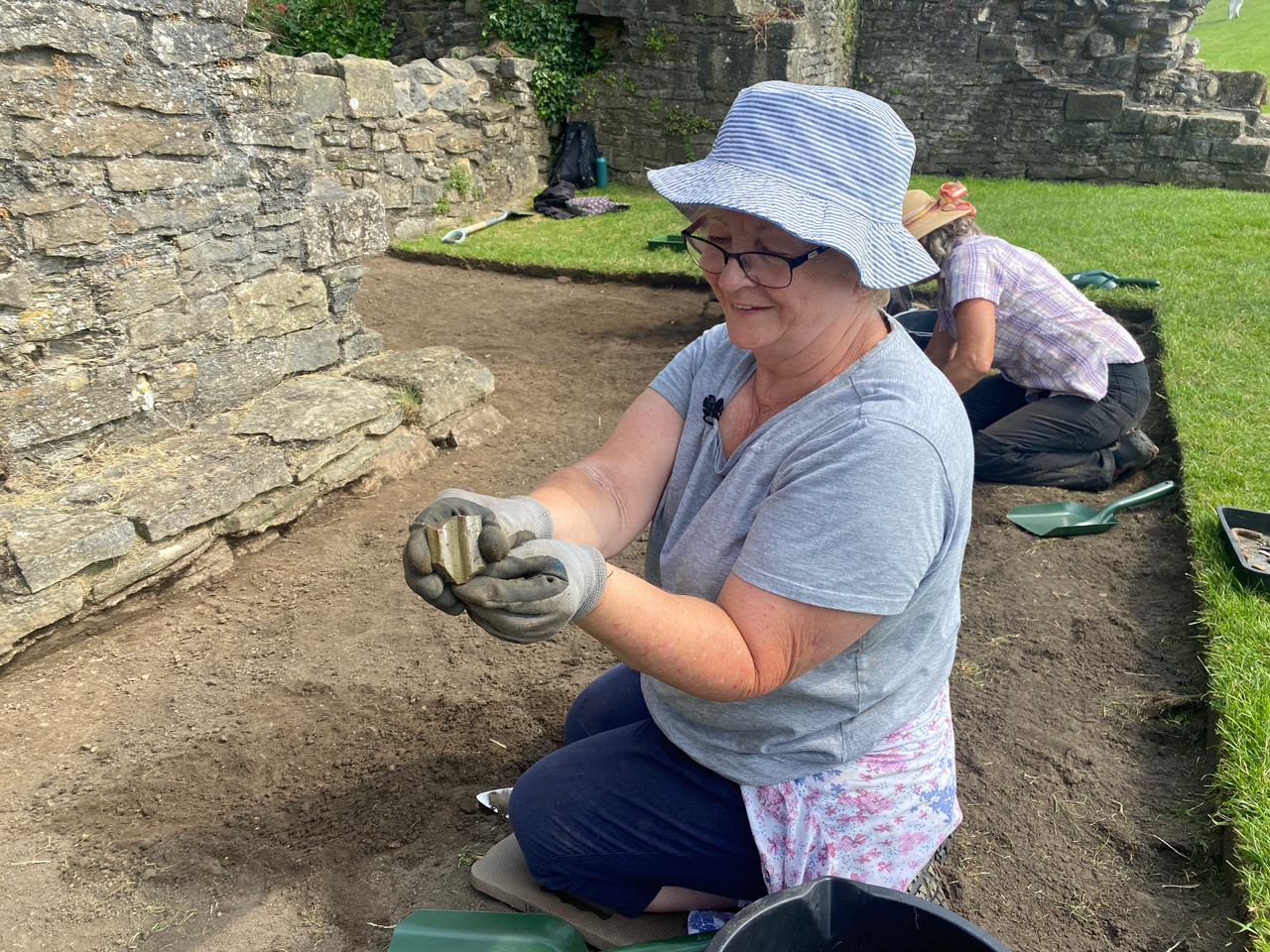
First days on excavations are always a little unusual as everything gets set up, people find their feet and there’s often not a lot in the way of instant rewards in the topsoil. That said, the reception we have received from the English Heritage team and the crowds of visitors to the castle has been wonderful. Sitting with a family on the edge of Trench 1 going through the various topsoil finds and letting them hold these artefacts in their hands will never be less than a fantastic experience.
Irene with the piece of green glazed pottery she found
The first handful of finds have already started to paint a picture of the dual nature of Richmond Castle. The early 20th century was well represented with a large tent peg (let’s imagine it was from the very tent of Robert Baden-Powell!), some scattered pottery and a small bullet casing. The most exciting moment, however, was when Irene pulled out the first piece of medieval pottery: a fantastic fragment of green-glazed handle from a large jug! A few more pieces followed near the end of the day, and we are all eager to see what is revealed as we start to get deeper.
Jim Brightman of Solstice Archaeology, dig director of the Richmond Castle excavation, outlines what the next three weeks of excavations of Richmond Castle to mark the 950th anniversary of its founding. The excavation is being co-funded by the Castle Studies Trust along with Richmond and District Civic Society and Richmond District Council.
By way of an introduction to the Richmond 950 community excavation, I’m going to start with a bit of a personal reminiscence. I am a former pupil at Richmond School, and in the dim and distant past when I was in in Lower School (the old Grammar School building), the first topic covered in history lessons was the medieval period. I’d already been fascinated by the past through primary school, and I was ready for it to be my favourite class. I wasn’t disappointed. On a seasonably warm autumn afternoon, we all trooped up the hill for our first site visit: Richmond Castle.
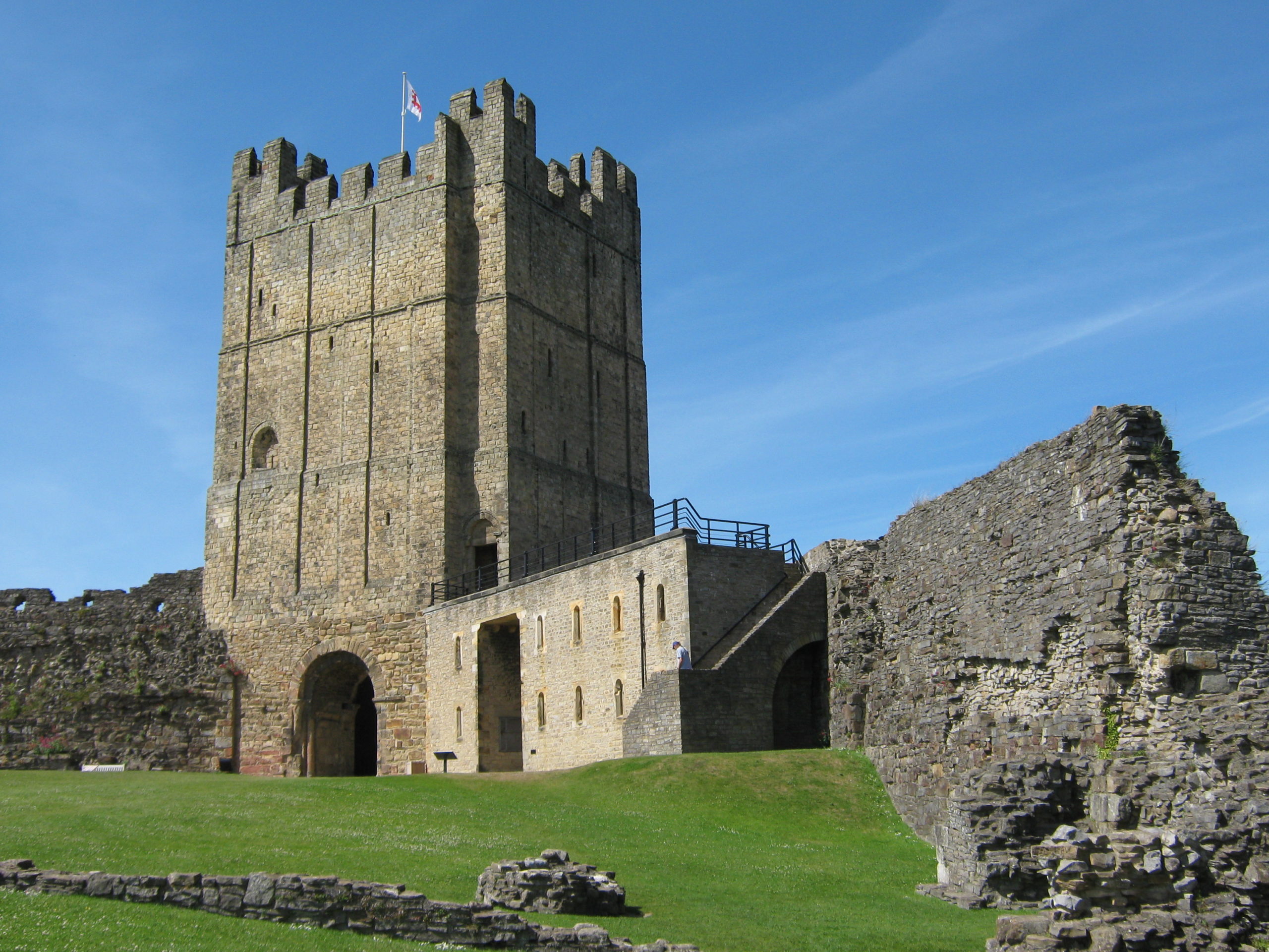
Many, many years later, having studied archaeology at university and spent my early career in and around the Peak District, I moved back home in 2012. The first time I walked back into town, I vividly remember thinking “was the Castle always that big?!”. Then as now, and as in the centuries preceding, the keep towers over the marketplace, easily the most prominent building in the town’s skyline. Indeed, I was so taken with this icon of my childhood love of history, that the outline of the Castle now features on my company’s stationery!
Richmond Castle’s Great from the Bailey near where some of the trenches will be placed. Picture courtesy of English Heritage.
With the 950th anniversary of the Castle’s original founding rapidly approaching, I was overjoyed at the opportunity to run a volunteer archaeology excavation as part of the wider celebrations being held in the town through the course of 2021. Having been fortunate enough to be involved in a lot of community archaeology projects through the course of my career, it felt like a real homecoming.
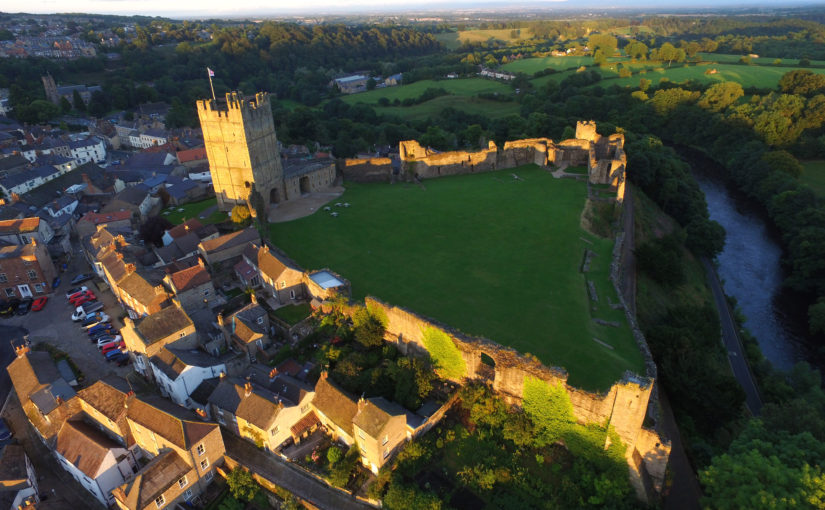
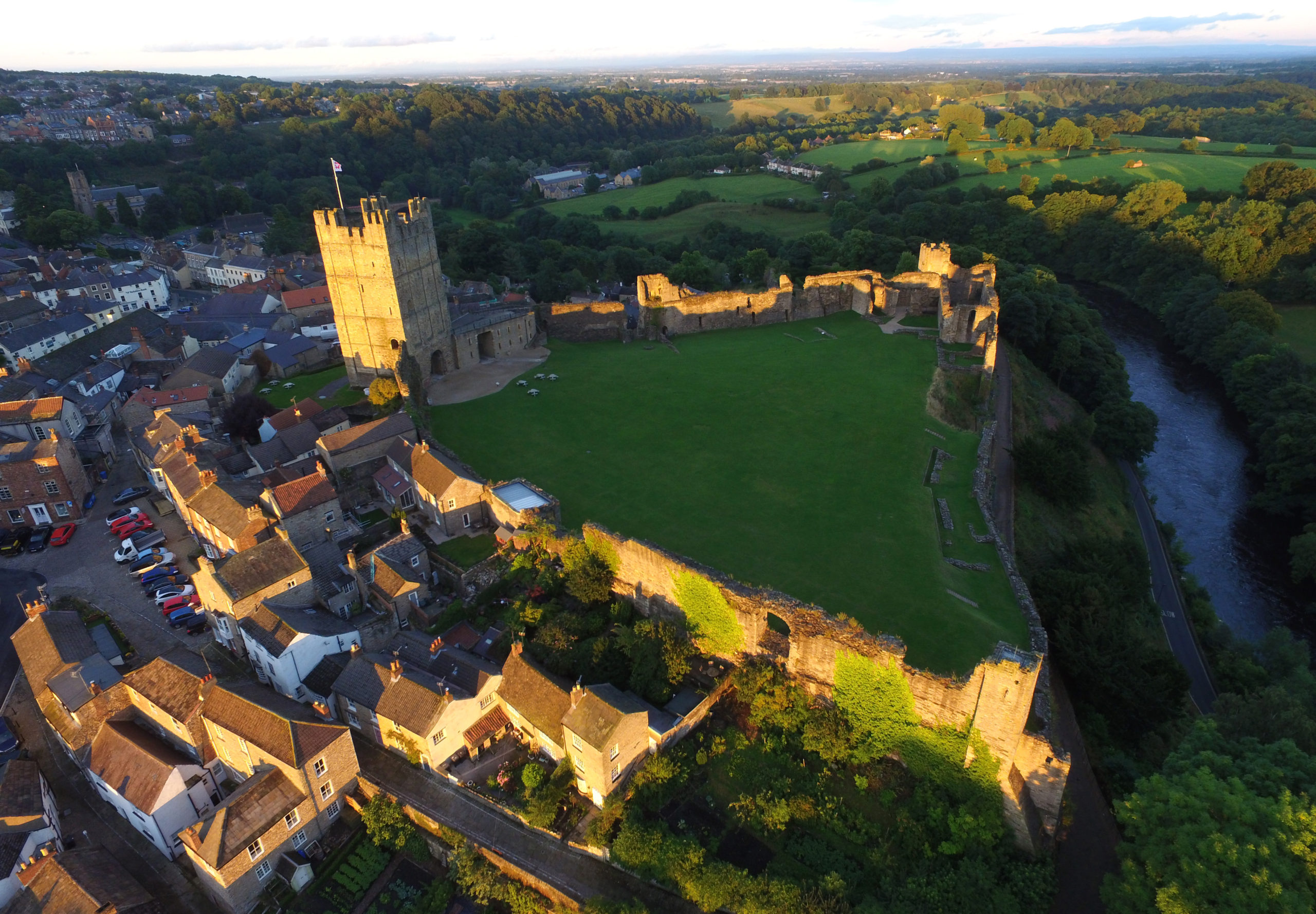
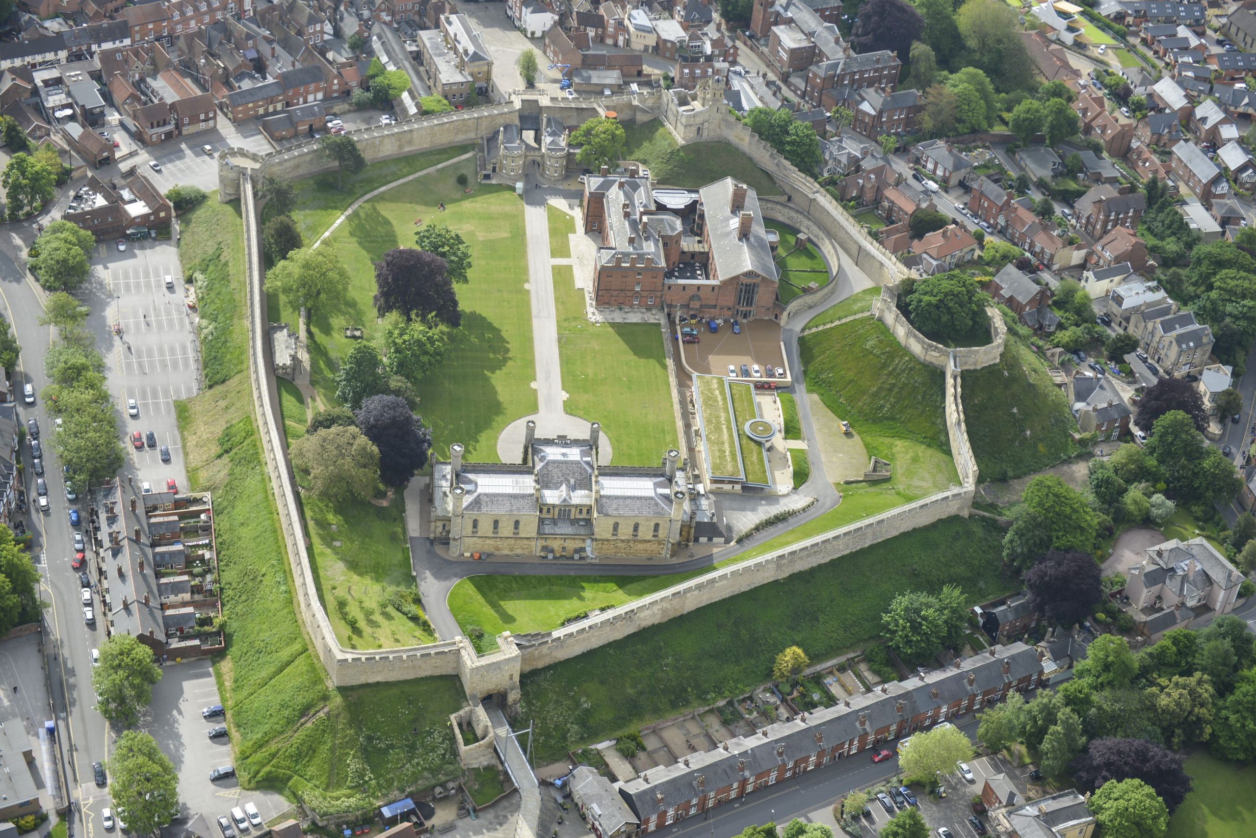
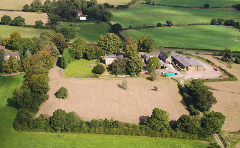
As we started developing the project, it became clear that there was a wealth of places within the Castle where targeted excavation had the potential to shed light on parts of its story that have remained hidden. Geophysical survey in recent years has revealed whole complexes of possible walls and structures beneath the grassy sward of the bailey, and Richmond 950 is the first time that they will see the light of day for many, many centuries.
Richmond Castle from the air. Most of the excavation will take place along the far wall where many remains have been located. Picture courtesy of English Heritage.
The volunteer archaeology project was made a reality by the kind support of several funders, all of whom believed in the vision of engaging local people directly with the tangible past in such a beautiful and historic setting. We are very grateful to the Castle Studies Trust, Richmond and District Civic Society and Richmondshire District Council for their huge generosity and support – I feel strongly we will repay your trust with a fantastic project!
As I write this on the eve of the project starting, we are almost fully booked in terms of volunteer places—a real testament to the interest in archaeology in and around Richmond. That said, if you are reading this and getting the itch to try your hand at archaeology, then there are still a few places available on our Eventbrite link; no experience is required and everything you need to unlock your inner Indiana Jones is provided! Even if you are just interested in finding out more, then the Castle is still open to visitors through the next three weeks while we are digging, and we would be delighted to talk you through the unfolding story of the archaeology.
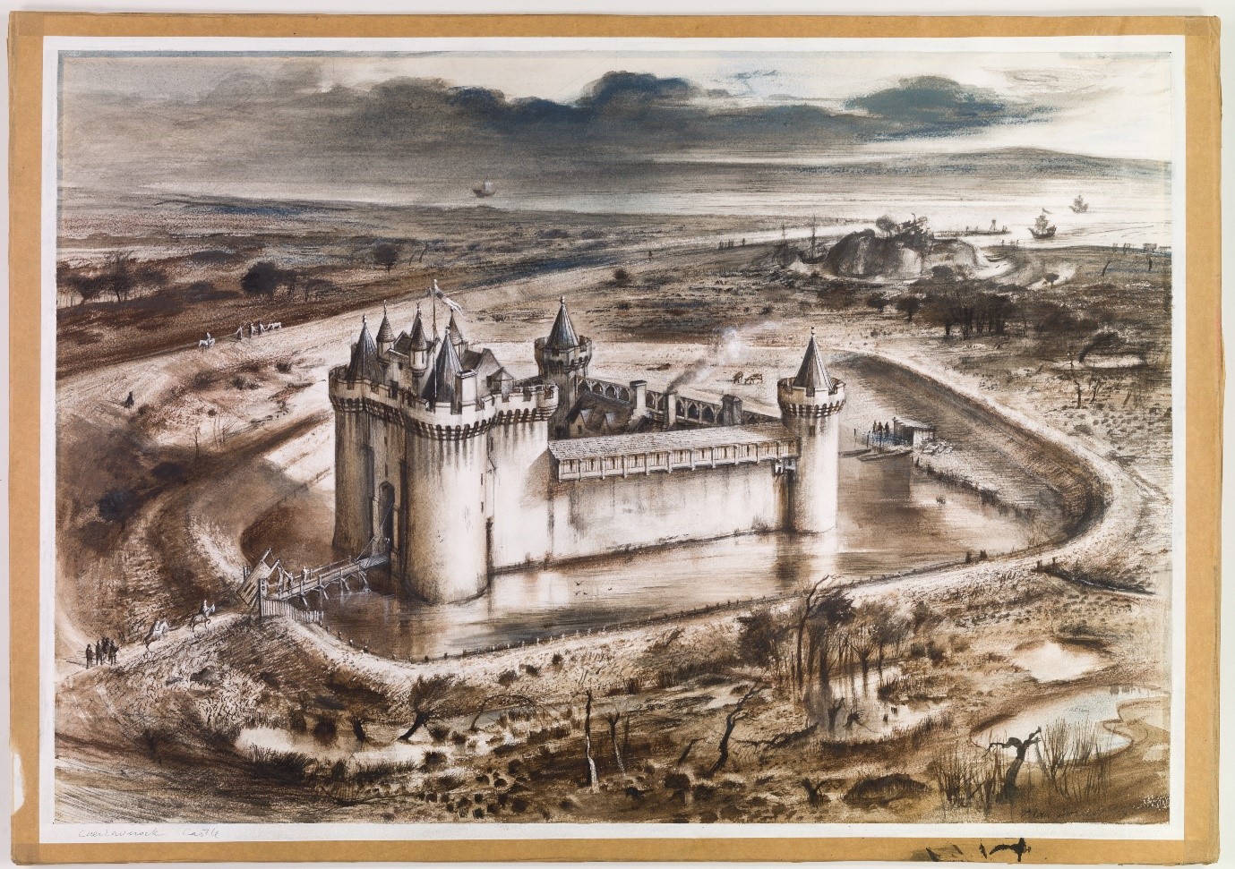
Project lead, Dr Richard Tipping, looks back at the first of the two weeks of fieldwork he and Dr Eileen Tisdall are undertaking to try establish whether climate change did impact the re-positioning of Caerlaverock Castle.
Well, somewhat later than planned or advertised, the first week of fieldwork at the old castle at Caerlaverock began on 3rd July. It has been dated by oak tree rings from the drawbridge across the moat to c. AD1229. The new castle, a couple of hundred metres away and upslope, began construction only 50 years later. Why the rebuild? This is the mystery.
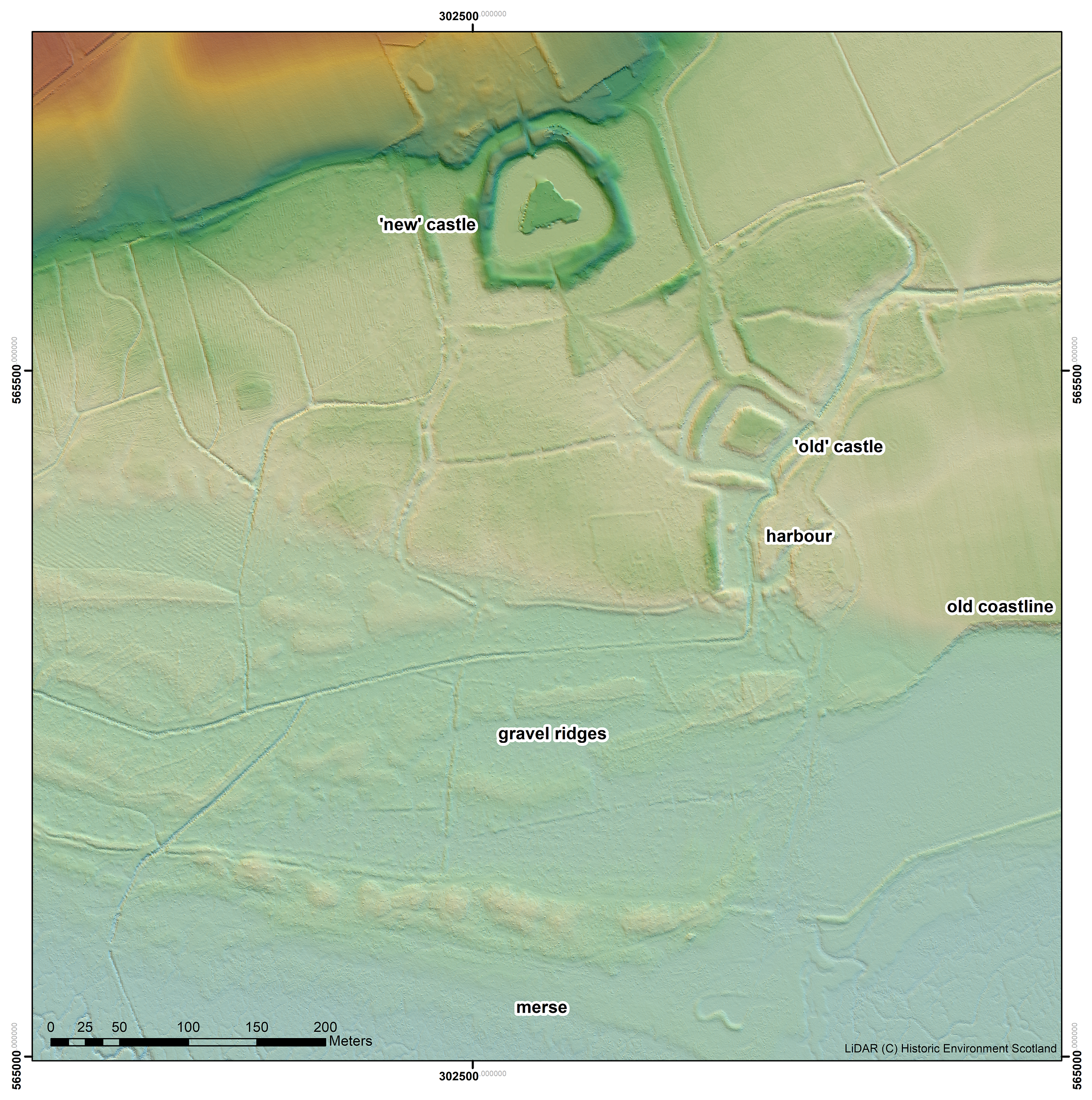
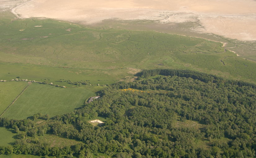
An image from a LiDAR survey, with the vegetation removed, showing the landscape and old coastline around the ‘old’ and ‘new’ castles at Caerlaverock
The natural environment played a role. Some archaeologists think the old castle started to fall apart because it was built on soft sediment, a deep clay-rich silt locally called ‘carse’. And sure enough, the new castle was built on the nearest outcrop of bedrock. But twenty years ago, a team of environmental archaeologists from the Universities of Stirling and Coventry found an additional reason for abandonment of the old castle. They found, in a wide ditch next to its moat, a thick layer of grey estuarine-marine mud penetrating the brown freshwater peat of the ditch. This suggested that very large storm surges impacted the environs of the old castle. Further work found very large gravel beach ridges, thrown up in these storms, stacked against the old shoreline.
That team included Dr Richard Tipping and Dr Eileen Tisdall from the University of Stirling. Now we are back to find more evidence and improve the dating of the sediments funded by the Castle Studies Trust, as Historic Environment Scotland, the custodians of both castles, seek to update what we know of Caerlaverock and improve the visitor experience.
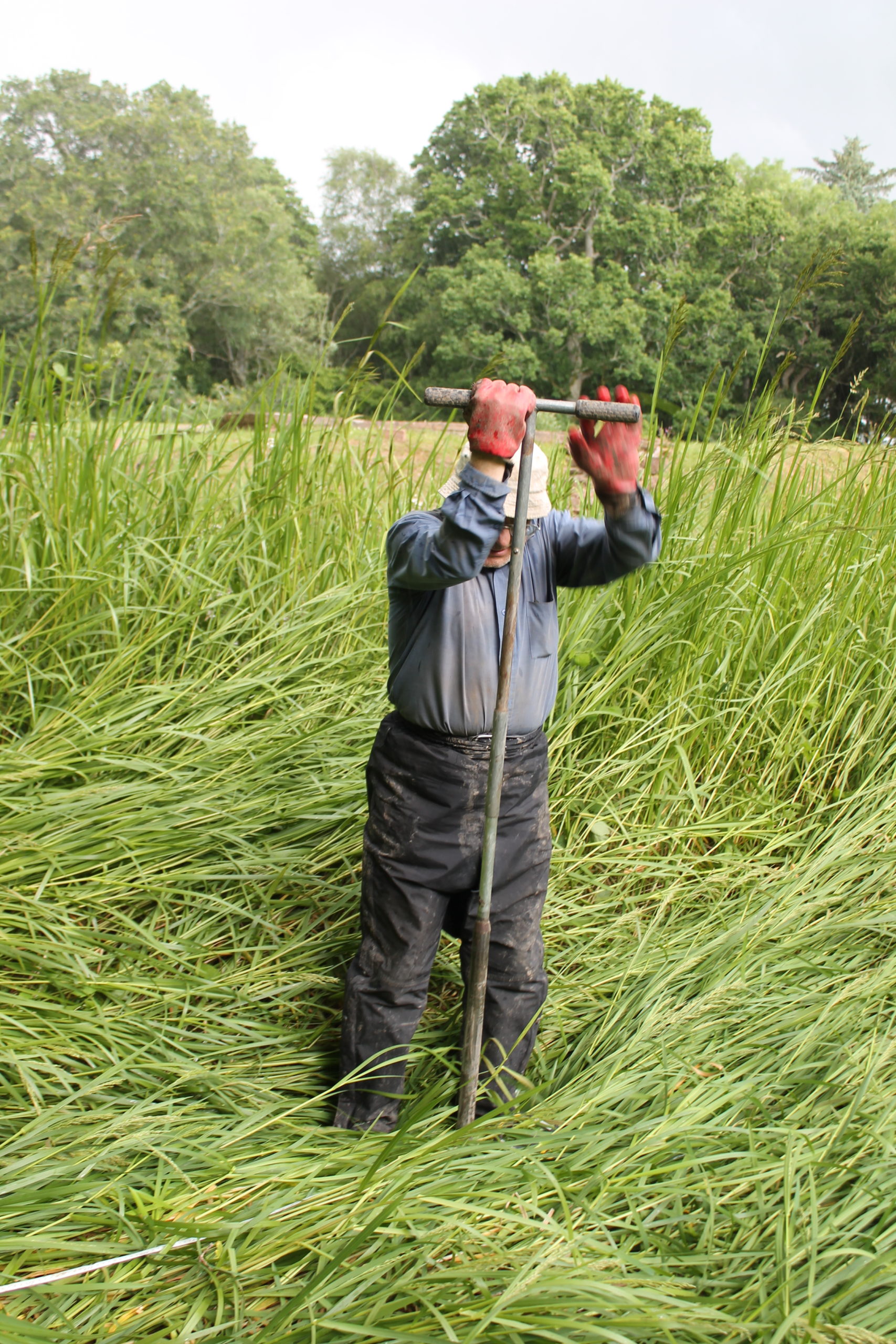
Dr Tipping using the ‘simple’ corer to extract sediment cores
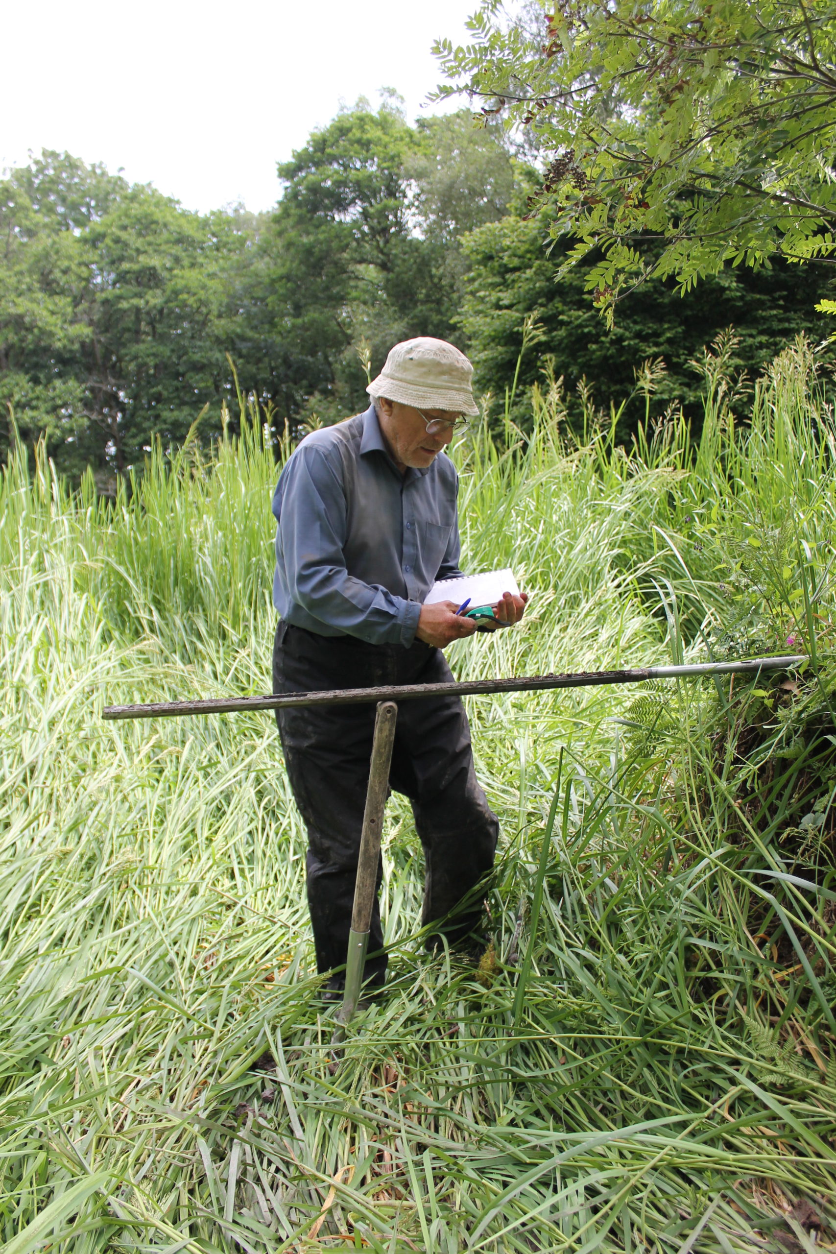
For a week, 3rd-10th July, Richard Tipping stuck tiny (2.5cm diameter) holes in sediments in the ditches and moat with a simple corer, a metre-long metal gutter with a handle on the end. Push it in, turn it around to cut out a sample and pull it out, together with a metre of sediment. Record the sediment and then repeat, usually in a straight line called a transect. He did this over 80 times in the week. Isn’t science exciting? It wasn’t too hard: the sediments in the ditches and moats are less than a metre thick before the ‘natural’, as archaeologists call it, the sterile silt of the ‘carse’. But because the sediments are so thin, and because we knew that they recorded a lot of environmental ‘events’ in a short period of time, logging the cores in detail took time. A challenge, too: there are only so many shades of grey or brown.
Dr Tipping logging the details of a sediment core
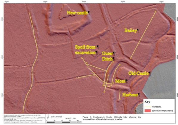
Coring started in the artificial ditch that runs parallel to the moat. This was where we first began, twenty years ago, to realise that something funny was going on; in fact, several funny things. Why, in the first place, dig a 60 m long, 3 m wide ditch alongside one side, and only one side, of the moat? Twenty years ago, radiocarbon dates on freshwater peat at the base of the ditch hinted that this ditch was actually earlier than the old castle, maybe 200 years earlier. We aim to clarify this. Coring found the same sediments we found last time, which is always reassuring. Peat at the base of the ditch was replaced by grey silt. This was sealed by more peat. There is more grey silt at the end of the ditch nearest the coast, although the upper layer penetrated the full 60 m length.
We could not understand, twenty years ago, the filling of the moat with sediment: too few boreholes, too far apart. This time, cores were spaced 1.5 to 3 m apart along a 40 m long line. Archaeologists generally excavate and record continuous sections. We can’t do this because the site is a Scheduled Monument, and besides, the sediment is under water (though this week mercifully dry underfoot), so we construct our section from transects of cores, ‘joining up the dots’ by correlation. For the first time we can show that the moat was probably affected by the same environmental impacts that hit the parallel ditch. This is only ‘probable’ because radiocarbon dating has yet to show the events are the same. But grey silt entered the moat from the coast, pushing up the moat, probably eroding earlier-formed peat but not penetrating the full length. At the end farthest from the coast, near the bridge, peat continued to form.
A line of flags showing the transect of boreholes in one arm of the moat, approaching the footbridge to the old Castle, itself precisely where the original drawbridge was.
Our cores also revealed two new aspects of moat construction. The first is that the constructors took a shortcut in making the moat. In two arms of the moat, they had incorporated natural stream channels in the moat, twice as deep as the rest of the moat. This was a way, of course, to ensure the moat was under water. But away from these channels, the ‘natural’ lay only 20-40 cm below the present sediment surface. If the water surface then was as it is now, the depth of water would have been barely above the knee. You might have waded to the castle rather than use the drawbridge.
Coring in parts of the moat also hit stone at shallow depths. The carse itself is stoneless, and so the stone was emplaced by people. Stabbing around with the corer revealed these stones to be large blocks. They are concentrated at one corner of the moat, nearest the coast. Maybe they were buttresses put in to strengthen the foundations of the castle, either as it started to subside, or maybe undermined by storm surges.
Now I’m thinking and planning the next part of the campaign, straightening my back, and hoping the insect bites subside: the joys of fieldwork. From 17th July we start again, for a week, away from the old castle and out onto the old beach ridges and the basins formed by them. In the early 2000s, tree-felling of Sitka spruce allowed us to see what we were doing. Now it’s a dense tangle of semi-natural oak woodland and not easy to move around in. Wish me luck!
Dr Sarah Jane Gibbon and Dan Lee (UHI Archaeology Institute / ORCA) project leads for the Castle Studies Trust funded project explain the reasons behind the excavations they are undertaking at The Wirk in the Orkneys and what they hope to achieve during their two week dig.
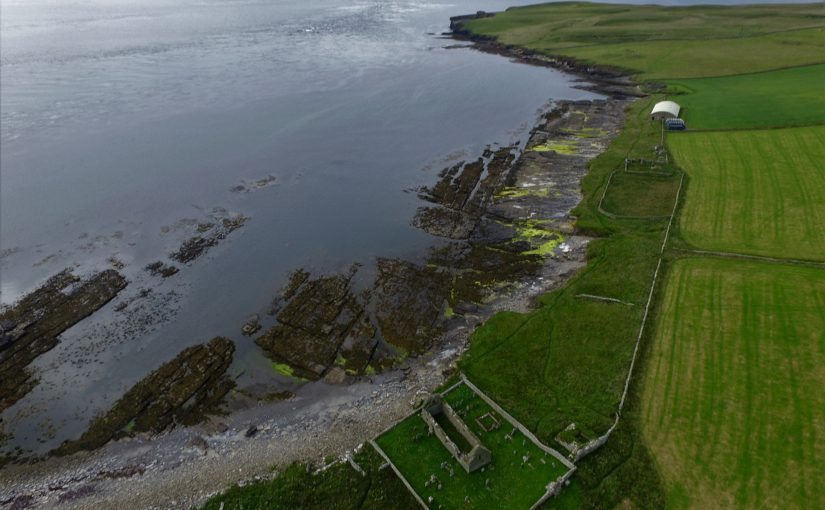
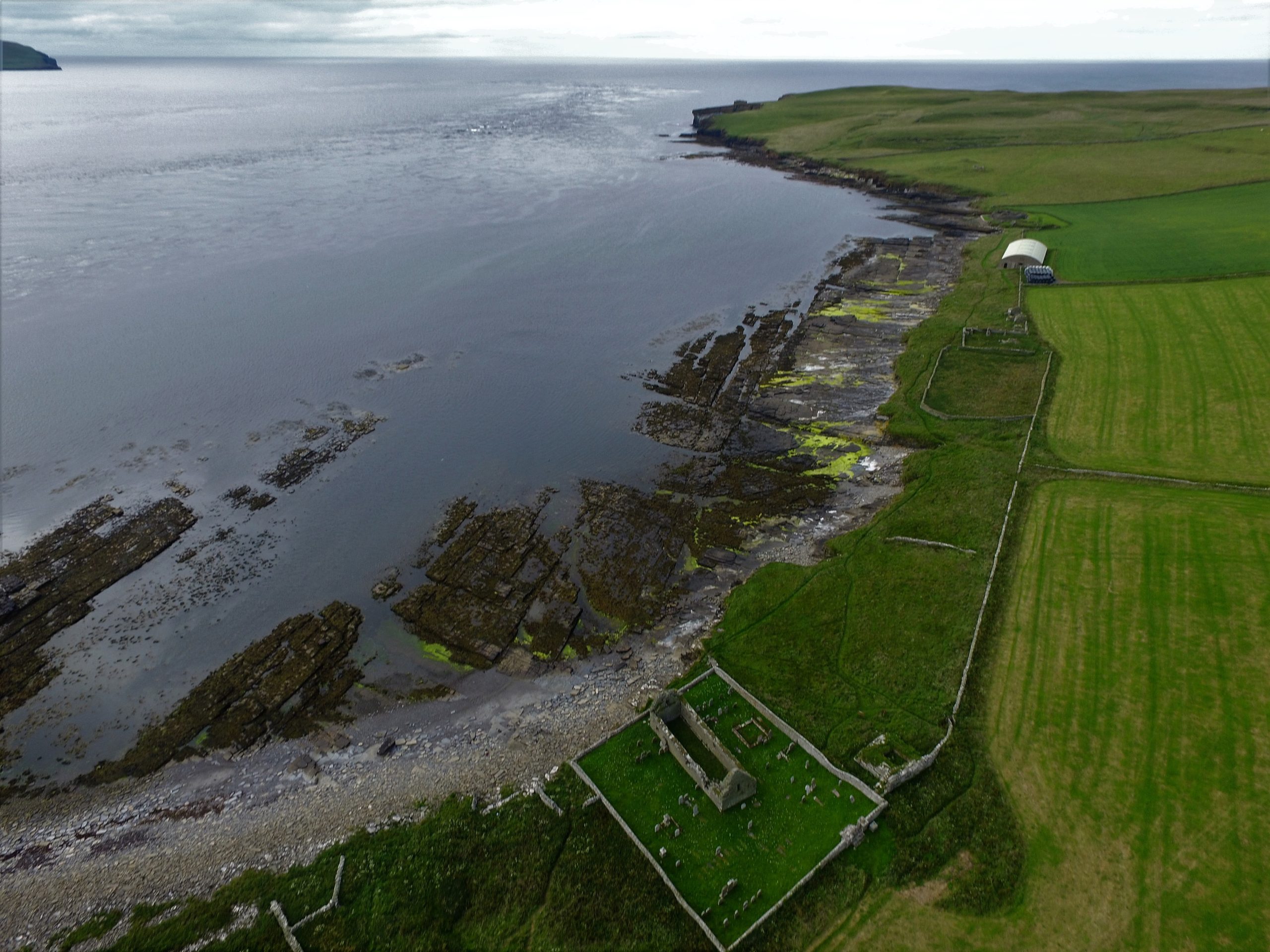
Located on the south-western coast of Rousay, The Wirk is located in one of the most archaeologically rich parts of Orkney. The Orkney Research Centre for Archaeology (ORCA) is undertaking geophysical survey, archaeological excavations and 3D modelling at this enigmatic castle site (pending approval from HES).
The Wirk, meaning stronghold in Old Norse, and with the alternative name Westness Castle, is a small stone tower located close to the coast. It has variously been interpreted as a 12th century Norse Castle, a detached fortified bell-tower, a 13th century defensive tower for an incomplete church, a hall-house garderobe tower and most recently a 16th century tower and attached range.
View of The Wirk, located on the righthand corner of St Mary’s Church yard in the foreground, looking northwest to Midhowe and the Atlantic Ocean (Image: Bobby Friel @TakeTheHighView).DCIM100MEDIADJI_0558.JPG
Minor clearance and excavation in the 1920s identified similarities in construction between The Wirk and the 12th century Cubbie Roo’s Castle, on the nearby island of Wyre, considered to be one of the earliest stone keeps in Scotland. The Wirk is located in Westness which has been a large estate since at least the 12th century when it was the home of the Norse chieftain Sigurd of Westness (Orkneyinga saga). It is adjacent to Rousay parish church, likely to date from the 12th century, with standing remains of 16th century date on earlier footings.
Recently, the 12th/13th century date attribution of The Wirk has been rejected in favour of a 16th century date. This new interpretation is based on the built remains and 16th century architectural fragments which were found in the 1920s. However, architectural fragments of 12th/13th century date were also present and nearby archaeology, particularly the discovery earlier this year of a Norse hall at Skaill by the UHI Archaeology Institute would suggest this was a high-status place in the saga period. This is not to dispute that The Wirk may also have been in use in the 16th century when the estate was owned by a prominent Orkney family. One of the objectives of this project is to excavate trial trenches over Clouston’s excavation and at the eastern end of the site to identify the earliest phases of the tower and adjacent building. Upper parts of the tower were substantially rebuilt in the 19th century and so excavation will allow us to record parts of the site that have not been knowingly rebuilt.
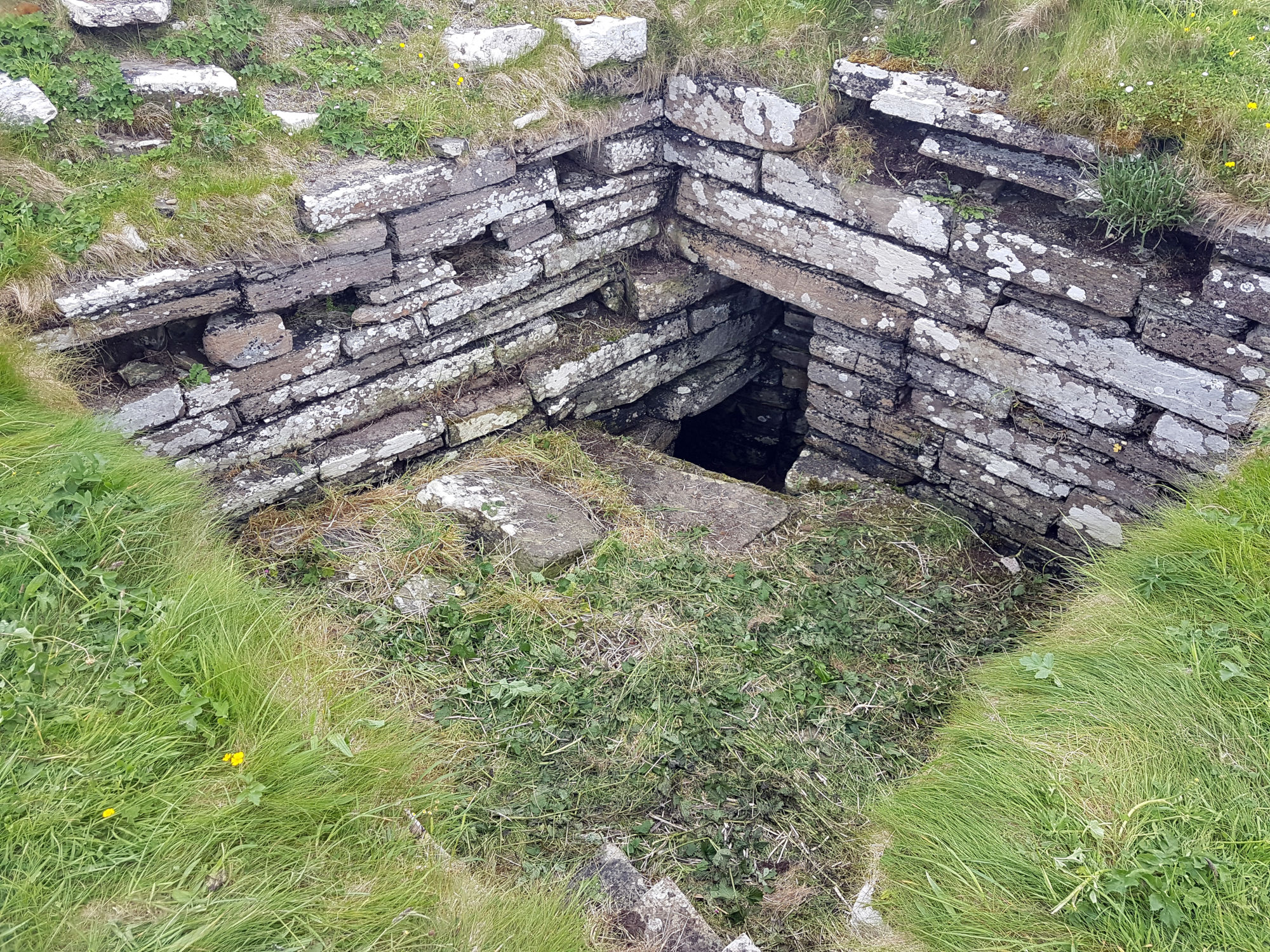
Inside The Wirk tower, looking southeast, showing the entrance to an underground well or passage (Image: Dan Lee)
Along with the excavations, targeted geophysical survey around The Wirk undertaken in September 2020 aims to better understand any relationships between the tower and the buildings/features which surround it. The results show that the walls planned by Clouston are accurate and that they likely survive just below the ground surface. 3D modelling of The Wirk and Cubbie Roo’s Castle will enhance our understanding of these comparable sites and allow the public to explore the remains online.
The start of the project was delayed in 2020 due to the Covid-19 pandemic, and we will be glad to finally get on site for the excavations in July.
As work starts on the Caerlaverock Weathering Extremes project, Richard Tipping of the University of Stirling and Morvern French from Historic Environment Scotland explains what they hope to achieve the work involved in doing that.
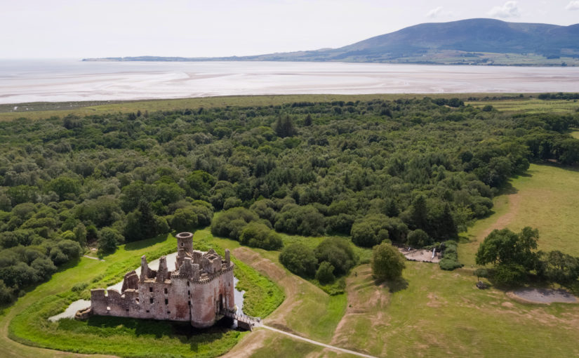
Some 800 years ago, a newly built castle at Caerlaverock, on the Solway Firth, was abandoned and a new one was built higher up the hill. The first castle fell victim to climate change as huge coastal storms hit the Solway coast in the medieval period. This was the conclusion of University of Stirling researchers at Caerlaverock Castle in 2004. This May, with support from the Castle Studies Trust and Historic Environment Scotland, the same researchers are going back to Caerlaverock to gather more and better data.
The Weathering Extremes project will look in more detail at the impacts these storm surges had on the old castle at Caerlaverock, the landscape, and its people. This castle was constructed around 1229, 800 years ago. Then, the castle was on the coast and had a harbour, and it had an important role in protecting Scotland from Edward I and guarding the entrance to the River Nith and Dumfries. But in 1300, when Edward I invaded southern Scotland, he famously laid siege to a new stone-built castle, a couple of hundred metres inland and five metres or so higher. This is the castle that thousands of visitors see every year, one of Historic Environment Scotland’s most impressive and most-visited properties. As we recover from Covid-19, Historic Environment Scotland wants to enhance the visitor experience. This means learning more.
Today, the old castle, tucked at the bottom of the hill, is in an uninviting, ill-drained wetland. It was probably like this in 1220. The moat, earthworks, and ditches surrounding it all filled with freshwater peat. But suddenly, the peat-filled ditches were invaded by silt and clay. Analyses of microscopic organisms called diatoms, which are marine or freshwater algae, showed that the silt and clay was marine, coming inland from the coast, probably through the harbour. Huge storms seem to have repeatedly hit the coast, and large curved storm-ridges of gravel were piled up. Some gravel came from the west side of the Nith estuary, driven across by storms. New LiDAR imagery has detected at least seven ridges, each twenty to thirty metres wide and tens of metres long. When the storms ceased, the old castle ended up some 400 metres distant from the coast. This provides new evidence which wasn’t available when the old castle was last excavated two decades ago, and when combined with this new fieldwork we will know so much more about the chronology and impact of climatic events at Caerlaverock.
Aerial plan of Caerlaverock old and new
In 2004 the above features were dated by radiocarbon, but new techniques now allow radiocarbon dating to be much more precise. So, this year, Dr Richard Tipping and Dr Eileen Tisdall, environmental scientists at the University of Stirling, will go back to what they studied in 2004. They will study the sediments more closely and collect more and better samples, to trace the environmental legacy of the medieval storms. There is much we do not yet know. When did the storms first hit the coast and why did they begin? Had the builders already experienced the earliest of these but carried on building regardless, driven by military concerns, or did the climate change only after the old castle was completed? How long did the period of storm surges last – decades or centuries? How powerful were they? How far inland did they penetrate? The north Solway shore is low-lying, and floods could have extended for kilometres inland, as we know some did later in the ‘little ice age’. Do these past impacts have meaning for what is to come in the 21st century?
In this initial stage of the project, Dr Tipping will establish a series of transects across the site and will then extract cores and samples for sediment description and stratigraphic analysis. Cores taken from the inter ridge basins will be used to locate in situ plant remains. More fieldwork will take place in the summer with Dr Tisdall and Dr Tim Kinnaird when further cores will be taken from the harbour and the outer moat of the old castle. Selected samples will later be subjected to radiocarbon dating and pollen and diatom analysis. Samples from the harbour will be optically stimulated luminescence dated by measuring the level of ionising radiation stored within the sands from exposure to light. From this we can calculate the last time the mineral was exposed to light, therefore finding out the dates of the sand deposits and the final period of the harbour’s use. We hope to have the first laboratory results later in 2021, with the final results due in spring 2022.
This fieldwork will enable us to better understand the use of the wider landscape at Caerlaverock, including medieval responses to climate change events and access to the coast for travel and trade. It will also tell us more about the medieval people who built the two castles, their experiences, and their motivations in locating the castles where they did.
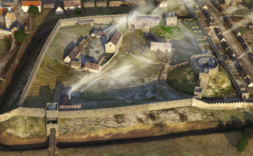
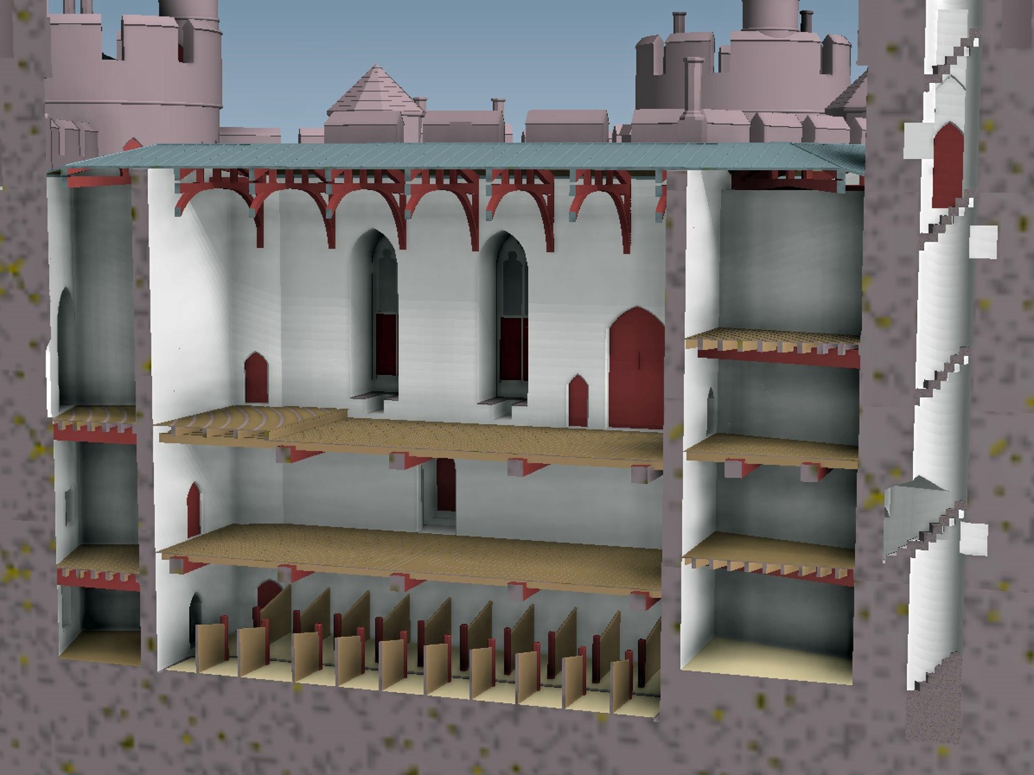
Dr Jonathan Clark, Historic Buildings Director, FAS Heritage and project lead for the Castle Studies Trust funded 3-D Reconstruction of C12 Lincoln Castle explains how it was done and the challenges faced in doing it.
A virtual 3-D reconstruction of Lincoln Castle as it may have looked in the late 12th-century has been completed by Peter Lorimer, Pighill Illustration in collaboration with FAS Heritage. The reconstruction was funded by the Castle Studies Trust and made possible through 15 years of archaeological research for the Lincoln Castle Revealed project. The project consisted of a £22m repair and restoration programme to conserve the site and renew the visitor experience funded by the National Lottery Heritage Fund, Lincolnshire County Council and the European Regional Development Fund. The programme provided opportunities for research-led archaeology which yielded a wealth of new information about the site.
Mondern day Lincoln Castle from the west copyright Andy Tyner Photography on behalf of FAS Heritage and Lincolnshire County CouncilLincoln Castle as it could have been in the late C12 copyright FAS Heritage and Pighill Illustrations
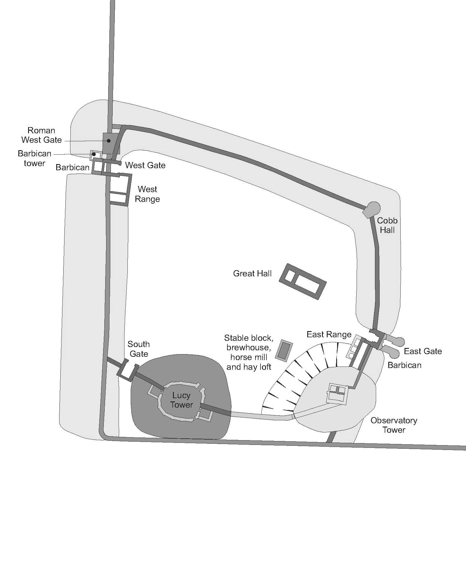
William the Conqueror established Lincoln Castle in 1068 in the walled enclosure of the former Roman colonia. The Lucy Tower motte was built in its southwest corner reusing the west and south walls to defend the new inner bailey. The next 100 years saw rapid development: originally earth and timber, the Conquest-period castle was replaced in masonry, a process now understood to have started by the 1080s including East and West Gates; by the early 12th century the stone enclosure of the bailey and internal gate ranges were complete, along with the Lucy Tower shell-keep and later Observatory Tower. Inner bailey buildings were also contacted during excavation including the Great Hall, stables, East Range and the Observatory Tower motte and ditch, all contributing information to the reconstruction. Evidence for a lost South Gate to match East and West Gates was found; along with a reappraisal of the early form of the Lucy Tower shell-keep it provided information about a former southern enclosure. This enclosure was abandoned, probably by the early 13th century, when the castle contracted to the form of the current enclosure.
It was the culmination of this intense century of development, arrived at by the late 12th century that was selected for the digital reconstruction.
Plan of Lincoln Castle in C12 copyright FAS Heritage
Archaeological excavation and detailed building recording formed most information about the early form of the castle, but the assembly of the 3-D reconstruction led to reappraisal of other parts of the castle; previously unnoticed anomalies were discovered which required further analysis.
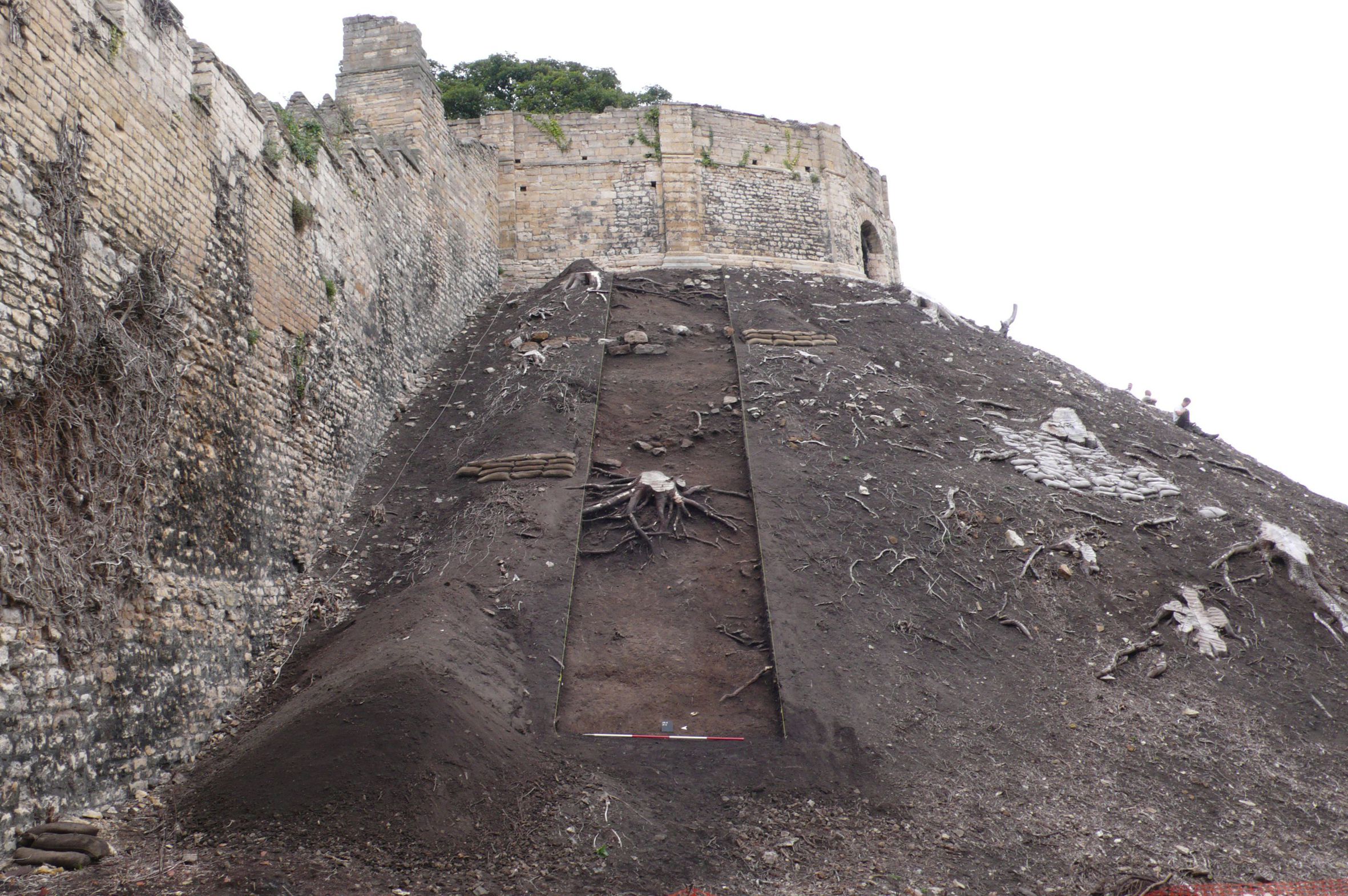
The lost southern enclosure and South Gate were both identified from fragmentary evidence and establishing the exact position and size of the original south wall presented a challenge. When reconstruction began there was little information on this wall except a projection of the line of the southern colonia wall. This placed the south wall slicing through the Lucy Tower motte – a relationship which did not seem likely. However, recent work on this part of the motte during a programme of banks stabilisation provided more information. A substantial medieval masonry wall measuring 3m wide and traversing the Lucy Tower motte west-east was revealed. The wall is probably founded on the Roman wall indicates the motte may have been constructed against it, flattening its southern side.
The Lucy Tower Motte after the removal of dense vegetation. The fragmentary masonry remains of a structure can be seen towards the top of the trench. Copyright FAS Heritage
The reconstruction provides a sense of where concentrations of occupation were; around East Gate and Observatory Tower, the Lucy Tower, the Great Hall and around West Gate. With the discovery of South Gate it is easier to appreciate how these areas were autonomous. Other areas within the castle, particularly the western side, are presented as large open spaces; without further investigation these zones cannot be reconstructed easily.
The Lucy Tower, sat upon on an enlarged motte, can now be shown with its original east and west chamber blocks, internal ranges and window overlooking the city. With the tower, wing walls and South Gate, these formed a discrete enclosure.
Detail on the form of the Observatory Tower in the late 12th century can also be added. The tower is shown as a gaol tower which replaced a predecessor developed by Earl Ranulf during the Anarchy, later commandeered to become the county gaol. A stone ‘skirt’ around the base of the motte and a motte ditch were found and formed a hard circuit detaching the gaol from the rest of the castle.
The reconstruction will be made available across a range of media. The analytical process and collaboration with Pighill Illustration provided an opportunity to translate the archaeological study of the castle into a tangible representation. It enables the results of the research programme to be conveyed to a wide audience and goes hand-in-hand with the publication of a book about the Lincoln Castle Revealed Project in July 2021.
Dr Stefan Magnussen of the University of Leipzig looks at the extraodinary case of Duchess Richardis of Schleswig who in the C14 protected her rights over a castle at the expense of her husband’s.
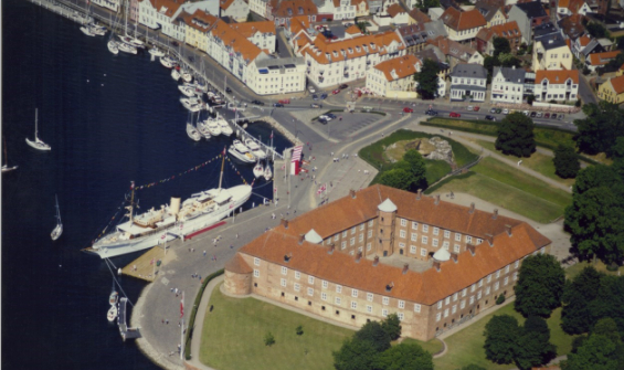
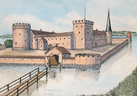
In south-western Denmark, not far from the mouth of the Flensburg Fjord, rises a red-brick castle called Sønderborg (Eng: Southern Castle). Although it is hardly known beyond Denmark, at least its name still radiates throughout Europe as the eponym of the dynasty that originated from it. We do not know today who built the castle, which was first mentioned in 1253, but the eventful history as a residence, in which many men have left an architectural imprint, is well documented.
Yet there were also some women who left their marks – this is especally true for Queen Dowager Dorothea of Saxe-Lauenburg, who commissioned the magnificent palace chapel. One key figure, however, has more or less fallen into oblivion: Duchess Richardis of Schleswig, who played a brief, but prominent role during a royal siege of 1358. Not so much as a leader of defence, but rather as a ruler who self-confidently defended her own interests – even if it meant turning against her spouse.
Overall, very little is known about this woman. She was born around 1320 as the daughter of the Counts of Schwerin-Wittenburg and probably married Duke Valdemar V of Schleswig around 1338, presumably in the course of alliance negotiations. As was customary in those years, she was probably assigned the ducal secondary residence of Sønderborg with the island of Alsen as life tenancy, which made her Lady of Sønderborg for almost half a century until her death around 1386. Nevertheless, apart from the fact that her chaplain came from her native Wittenburg, little is known about her regency. Even her burial place remains a secret.
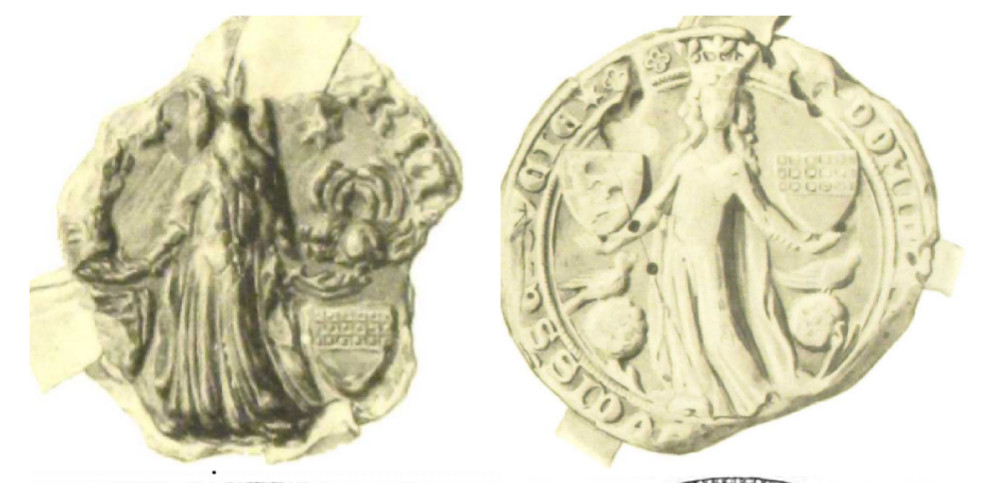
The preserved Seals of Richardis of Schleswig, indicating her heritage from the Counts of Schwerin-Wittenburg. Source: Thiset, Danmarks Kongelige Sigiller, Tab. 42
And yet what makes this enigmatic princess interesting is her key role in her husband‘s conflict with King Valdemar IV of Denmark. Understanding this and her stuation, it is worth telling the story from the beginning: In 1340, King Valdemar IV inherited a difficult legacy, as his realm was almost entirely pledged to various neighbours. Before homage was paid, a series of treaties reorganised these pledges, transferring almost all of Jutland to Duke Valdemar V, who in turn mortgaged his territories to the Counts of Holstein, who were among the leading negotiators. Within a few years, the Danish king succeeded in almost completely redeeming his realm, with the exception of some districts like Ribe Castle on the North Sea, which was still in ducal possession. At the same time, the Duke also succeeded in redeeming two thirds of his duchy from the Counts, who, however, remained holding the ducal principal residence at Gottorp. Since the secondary residence of Sønderborg had also been ceded to the Duchess, the castle district of Ribe constituted the last ducal power base. Notwithstanding this, King Valdemar IV. pressed for this pledge to be dissolved in 1351, which severely curtailed the Duke‘s power. In turn, the duke allied himself with the loyal Jutish nobility and the Counts of Holstein against the Danish king. An early conflict was settled in 1353, but flared up again in 1358.
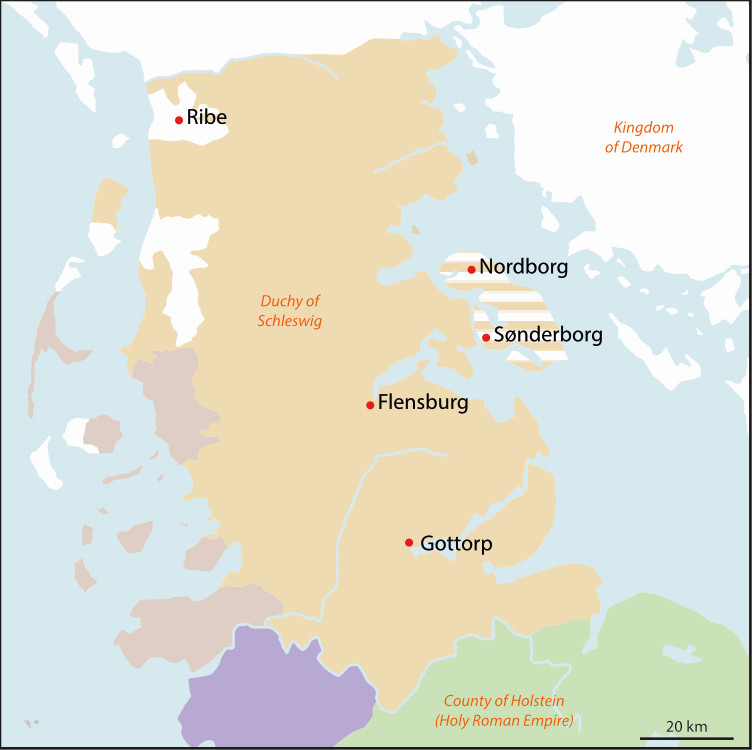
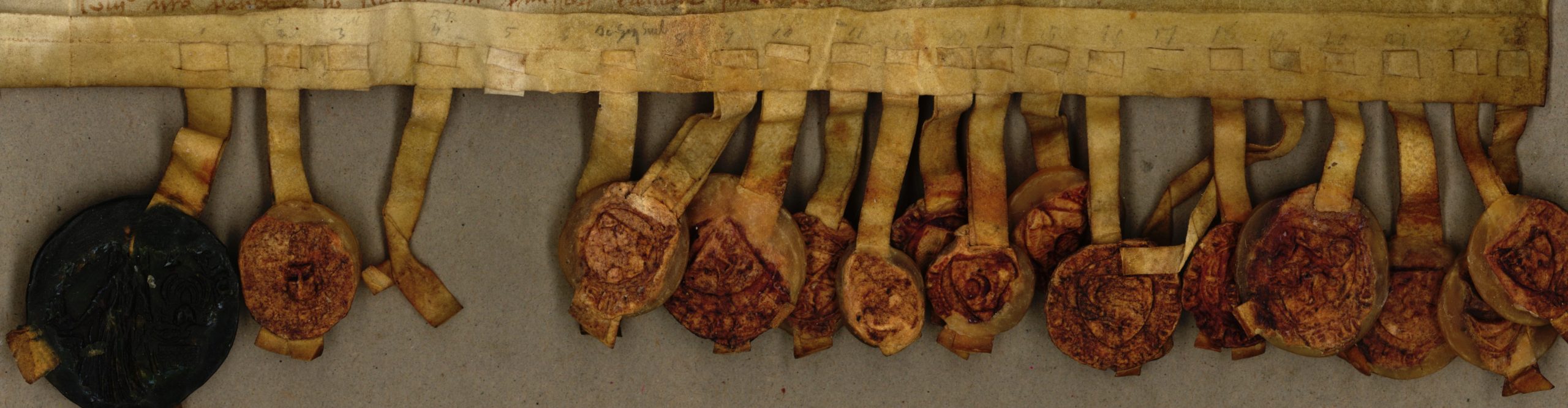
Map of medieval Denmark with the island of Alsen and the castles mentioned in the article, by Stefan Magnussen
King Valdemar IV now ventured an advance on the island of Alsen, which lay just off the coast of the duchy in the direction of the kingdom. Within three days he was able to bring Nordborg Castle (Eng: North Castle) under his control, making the conquest of Sønderborg only a matter of time. But it was not the Duke awaiting him there, but Duchess Richardis. The main source for the recreation of the processes now taking place is the contemporary and royalist Younger Zealand Chronicle, which, albeit otherwise only reporting sieges in short, recounts the meeting in surprisingly colourful words. Richardis, together with „her girls“, which probably referred to her dames, had approached the King outside her castle. As she was a fine, clever and, morever, eloquent person, the Danish king immediately recognised her noble personality and decided that his friendship with her brother was more dear to him than enmity with the Duke. Both sides thus agreed that Richardis would be allowed to keep her estate undiminished in return for her promise that no harm would derive from it. That these events actually occurred is witnesses by a preserved charter, which also informs us of another juicy detail: Richardis also banned her husband from staying in his castle. It was only on two days a year that he was allowed to stay there.
Seals attached to the Charter from June 19, 1358, source: Dansk Nationalarkivet, Ny Kronologisk Række (1980–1981), Nr. 832-c.
So, how can we explain these events and, above all, this dazzling account? Apparently, in the face of the siege, Richardis proved to be a princess with a sense of rank who knew how to protect her sphere of power. With Duke Valdemar V having only a small remaining territory and little income since the loss of his most important castle of Ribe, Richardis had little to rely on from her politically incapacitated husband. Yet, Richardis probably anticipated the royal dilemma, for her brother was one of the king‘s key allies. The duchess and the Danish king thus agreed on a mutually beneficial solution that would potentially establish a royal bridgehead at the doorstep of the Duchy. This agreement, however, had a crucial pitfall in that the castle de iure belonged to the Duke, which legally limited the authority of the Duchess to freely dispose of it. But both sides sought to actively influence the interpretative authority of this conflict between norm and practice via the contract as well as the chronicle. This is indicated by the comparatively extensive set of 21 seals, which may have been intended to symbolise broad support by local elites, but also by the very favourable account of Richardis, which was probably intended to strengthen her personal authority and thus bestow legitimacy on the agreement. Both seem to have succeeded in this endeavour, for in the winter of 1372/73 Valdemar IV was able to use Sønderborg castle as his bridgehead during his advance on the city of Flensburg, and Duke Valdemar V is never again witnessed on Sønderborg Castle until his death in 1364.
Even though Richardis has been forgotten down the years, her brief, but crucial role during the siege of Sønderborg is a vivid testimony to the often concealed power of princesses, who, instead of being a sidekick to their spouses, started themselves to kick if necessary.
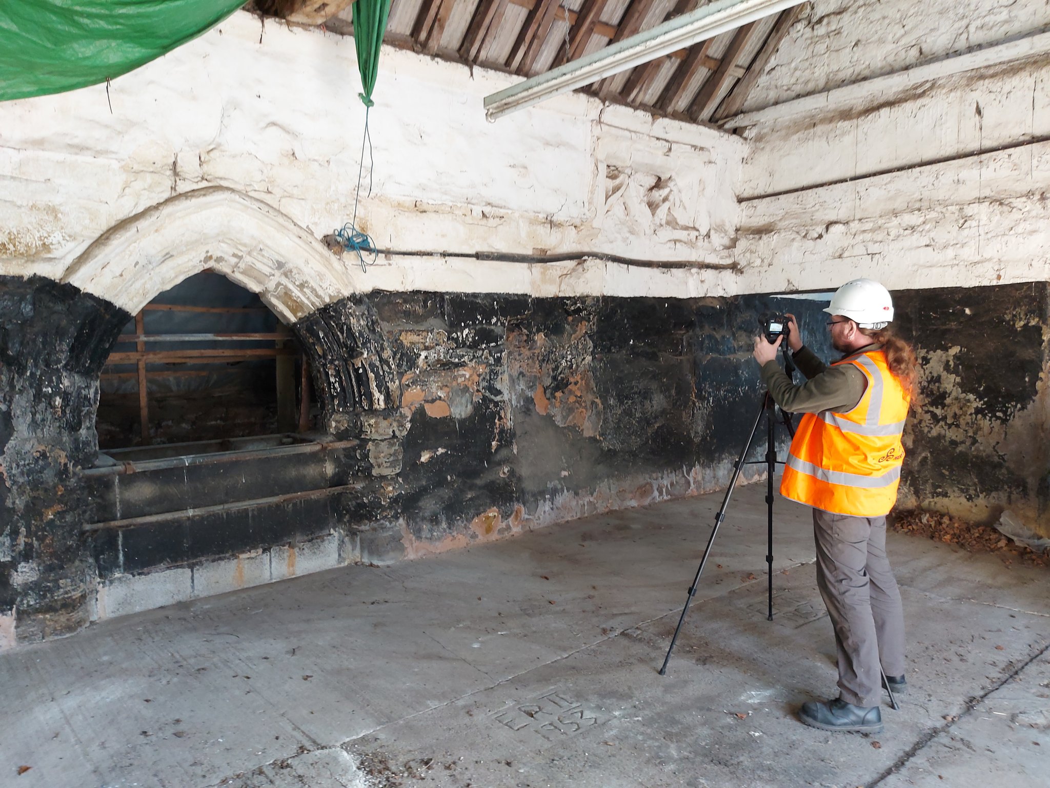
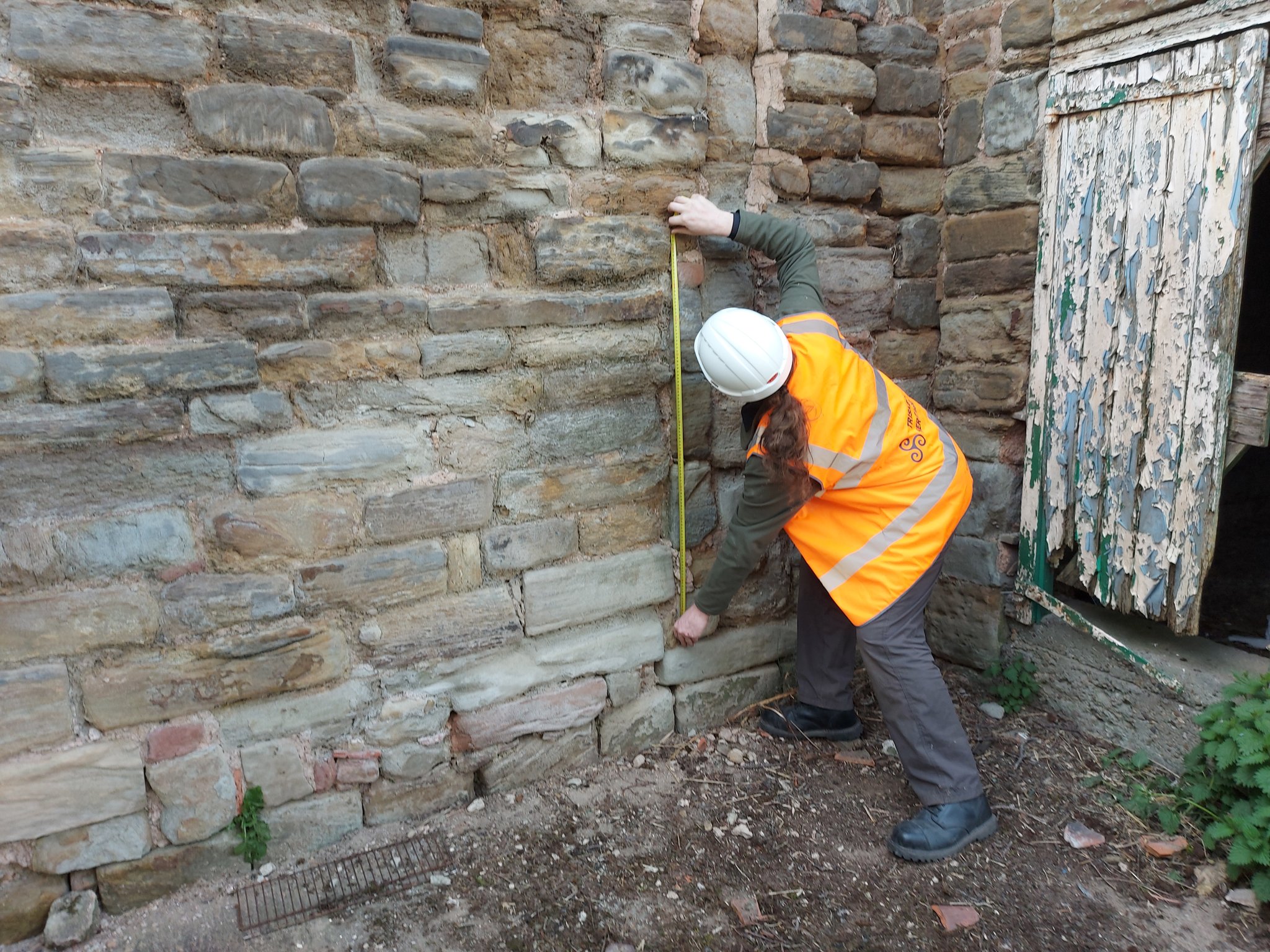
Back in January 2021 Triskele Heritage were successful in a funding bid to the Castle Studies Trust for carrying out a research project atGreasley Castle in Nottinghamshire. Here James Wright of Triskele Heritage explains what they hope to achieve with this project.
The work will focus on the production of an interpretative phased floor plan. The castle, built in the 1340s, has an obscure history and the understanding of its architectural phasing is at best very cloudy. The site is now a working farm and a number of post-mediaeval structures have been conglomerated around the remains of what is suspected to be a fourteenth century courtyard house with projecting corner towers.
The survey will act as baseline research data for a site which has not previously received serious fieldwork or publication. It will also provide a basis for further research and future conservation needs.
Work on the project will start in April 2021 and will be carried out by James Wright FSA alongside Dr Matt Beresford. We are supported in this endeavour by the landowners and Sarah Seaton of the Greasley Castle and Manor Farm History Project.
Greasley survey in action – photogrammetry
Project Background
Greasley Castle was developed for Nicholas, 3rd Baron Cantelupe (c 1301-55) after being granted a licence to crenellate by Edward III in 1340 (Davis 2006-07, 239). He was a significant figure who fought for the king in France and Scotland, served in parliament, founded Beauvale Priory and established a chantry at Lincoln Cathedral (Green 1934). Later owners of the site included John Lord Zouche – one of the few aristocrats proven to have fought for Richard III at Bosworth (Skidmore 2013, 330). After Zouche’s attainder, the castle was given to Sir John Savage in recognition for his military support of Henry VII in 1485 and remained in the family after his death at the siege of Boulogne (Green 1934).
The site is now a working farm and comprises two grade II listed buildings (NHL 1247955 and 1248033) overlying a scheduled ancient monument (NHL 1020943). The buildings sit along the northern perimeter of a 5.18 hectare earthwork enclosure and comprise a multi-phased U-shaped group of structures with an adjacent farmhouse to the north-west. The layout of the site is not well understood, but very limited prior research indicates the potential for a courtyard house with projecting corner towers.
The most substantive work on site took place in 1933 and comprised just two days of rather inadequate and poorly reported archaeological evaluation (Green 1934, 34-53). During the mid-2000s the wider landscape of the site was considered by the East Midlands Earthwork Project (Speight 2006). Greasley is routinely mentioned in surveys of castles stretching as far back as the antiquarian Throsby (1797, 239-42) and the early castle scholar Mackenzie (1896, 448-49). Although these initial commentators were of the opinion that little or nothing remained of the mediaeval castle, twentieth century authors, including Pevsner (1951, 76), his later editors (Pevsner & Williamson 1979, 135), Sarah Speight (1995, 70-71) and Oliver Creighton (1998, 479), noted in situ structures. In the twenty-first century a number of writers have pointed towards the tremendous archaeological potential of the surviving mediaeval architectural features (Emery 2000, 327; Salter 2002, 85; Wright 2008, 49-50, 65; Osbourne, 2014, 39).
Greasley survey in action: measuring
Crucially, the potential of the site has never been realised. Green (1934) noted that ‘it is not possible to be definite’ about the ground plan of the castle; a point later confirmed by Creighton (1998, 479): ‘the deficiency of the field evidence renders the exact nature and extent… obscure.’ The confusion surrounding the floor plan of the castle has been created by an overall lack of fieldwork and publication on the site. The paucity of research has led to a number of conflicting statements regarding the buildings archaeology. For example, the National Heritage List notes that the farmhouse was built c 1800 and has later nineteenth century elements (NHL 1247955); however, the most recent Pevsner edition notes that it is a seventeenth and eighteenth century building ‘with earlier origins’ (Hartwell, Pevsner & Williamson 2020, 240).
The proposed project to accurately map, assess and date the overall floor plan of the structures at Greasley Castle is long overdue and such building recording of manorial centres is specifically called for by the East Midlands research agenda (Knight, Vyner & Allen 2012, 94).
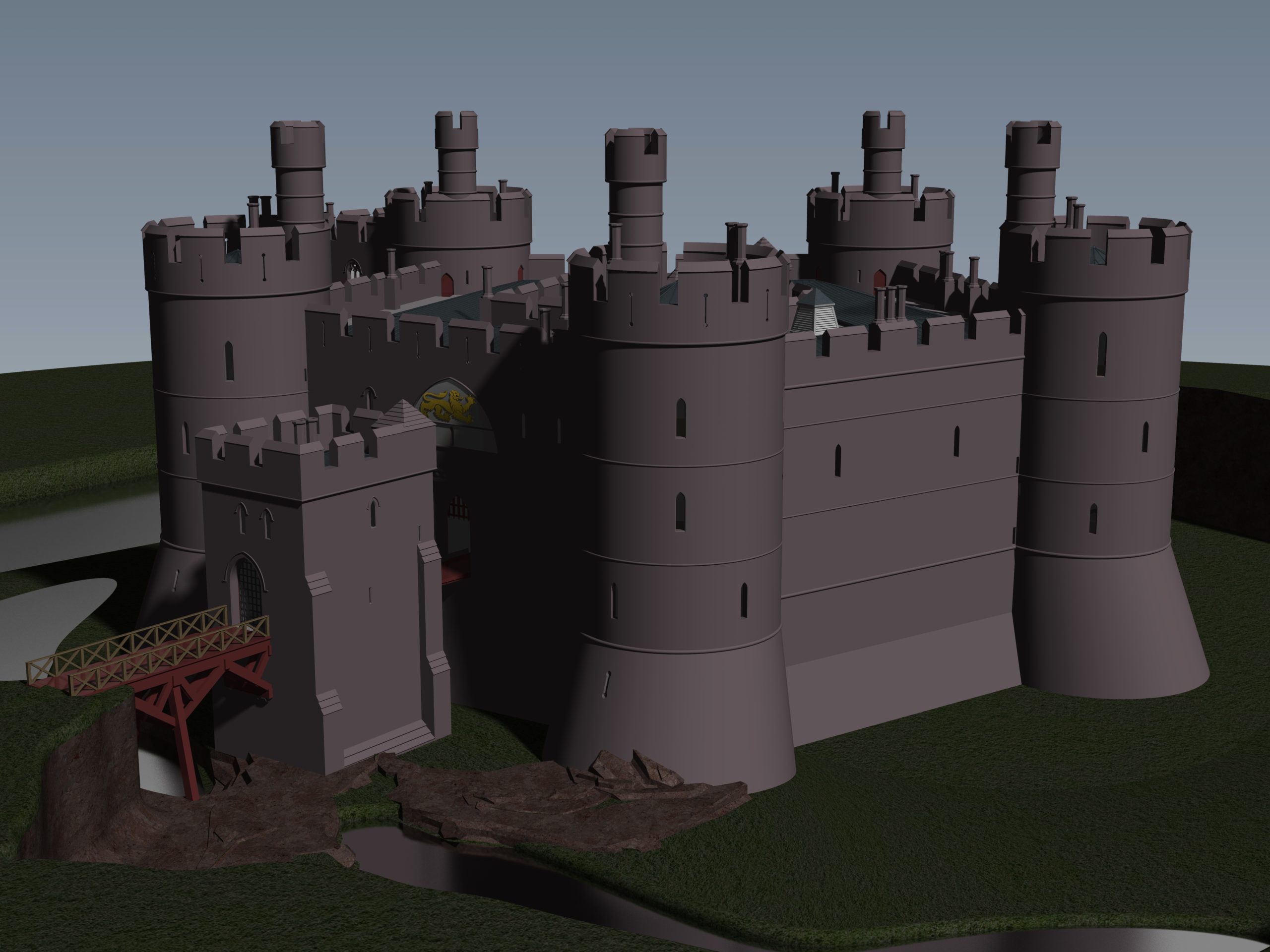
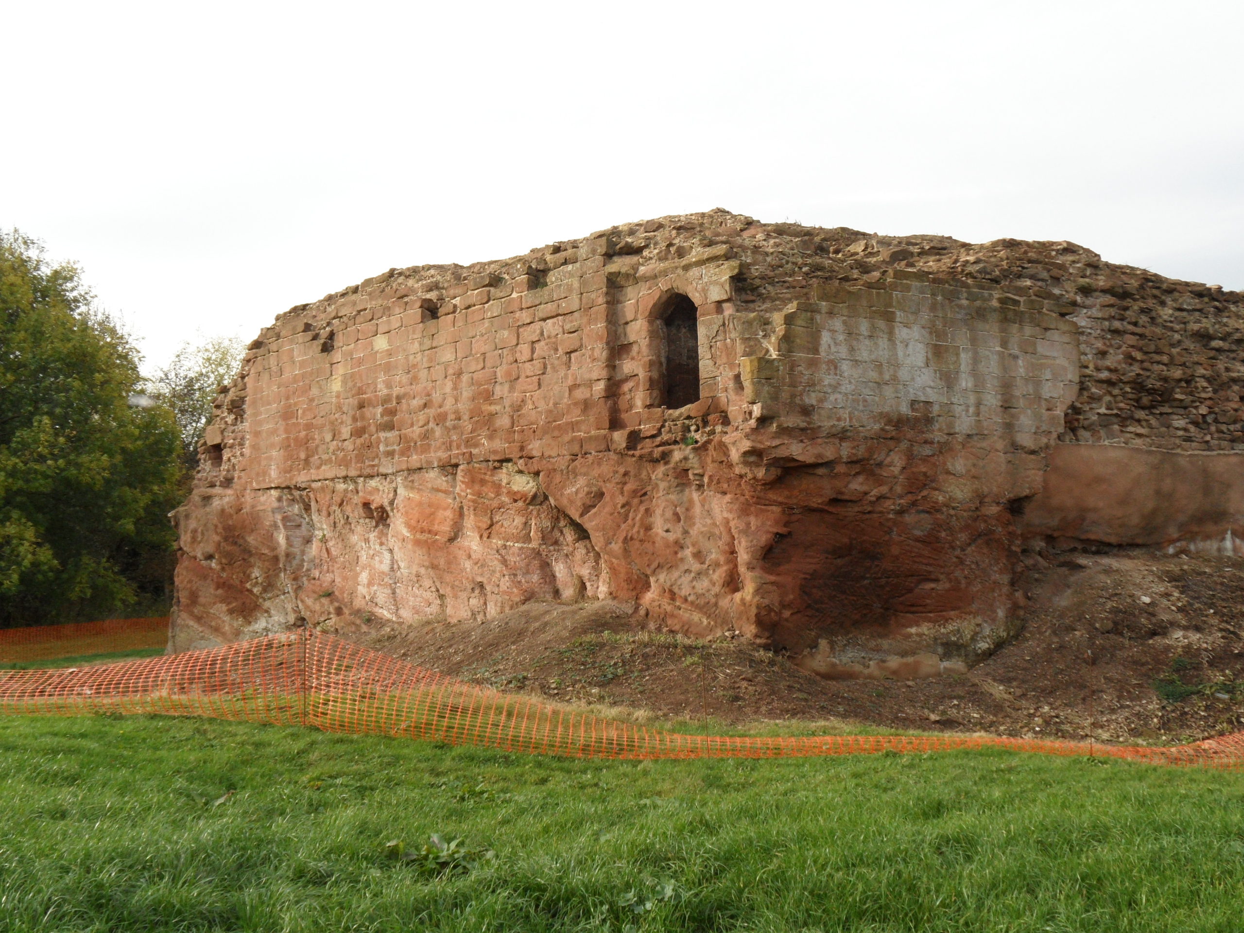
Little physically now remains of Holt Castle, however, one of the first projects the Castle Studies Trust was for leading buildings reconstruction artist Chris Jones-Jenkins and the late and much missed Dr Rick Turner to digitally reconstruct the castle using a mixture of historical sources and recent archaeological excavations to bring the castle back to life with a series of images and a video fly through. Here, in a piece first published in History Extra in 2015 explains how it was done.
To secure his conquest of north-east Wales, Edward I created five new Marcher lordships in 1282, and gave them as reward to his political allies and close friends in recognition of their loyal service. The lordship of Bromfield and Yale was granted to John de Warenne, sixth earl of Surrey (1231-1304). It is not known when he started building Castrum Leonis or ‘Chastellion’ as Holt Castle was known in the Middle Ages. The castle is first referred to in 1311 some years after it was probably completed. Warenne’s master mason chose an open and relatively flat site above the west bank of the River Dee, close to one of the ferry crossings into Cheshire. This allowed him to create a symmetrical pentagonal castle with a tall round tower at each corner, and the main rooms ranged around an inner courtyard. There were up to three storeys raised above the original ground level, with the moat and up to additional three basement levels cut down into the sandstone bedrock. It was a revolutionary design and was one of a group of similar architectural experiments being undertaken by the other new Marcher Lords at castles such as Denbigh, Ruthin and Chirk. At all these sites geometrical complexity, architectural grandeur and the provision of well-appointed accommodation seemed to be more important than their defensive capabilities.
Holt Castle as it was in its pomp courtesy of Chris Jones Jenkins
The sixth earl was succeeded by his grandson John, the seventh earl of Surrey (1286-1347). Described by Alison Weir as ‘a nasty, brutal man with scarcely one redeemable quality’, he was involved with the political upheavals of Edward II’s reign, including the loss of Holt Castle for a time to Thomas, earl of Lancaster. This John died without a legitimate heir, and Edward III intervened to settle his estates upon Richard FitzAlan, third earl of Arundel (c.1313-1376). His son, Richard the fourth earl (1346-1397) was one of the ‘Lords Appellant’, who had curbed Richard II’s powers and had the king’s closest allies executed or exiled during the ‘Merciless Parliament’ of 1388. It took nine years before the king was able to wreak his revenge on these powerful men. Arundel was brought to trial for treason at Westminster on 21 September 1397, and was convicted and beheaded on the same day. Richard II seized his estates and incorporated Bromfield and Yale into his new principality of Cheshire, with Holt Castle as its main stronghold. Building work was commissioned in 1398, which saw the Chapel Tower extended and included a water-gate, called ‘Pottrell’s Pit’ in later documents, linked to the river. Over the next year more than £40,000 in coin, jewellery, gold and silver plate was transferred from the royal treasury in London to Holt for safe keeping. When Henry Bolingbroke – later Henry IV – returned to England in 1399, he shadowed Richard II up the Welsh Marches and was quick to recapture Holt Castle. Despite being defended by 100 men-at-arms and being well provisioned, Henry’s men, including the French chronicler Jean Creton, were able to enter through the new water-gate and ascend ‘on foot, step by step’, to take the castle unopposed and so recover this vast proportion of the king’s disposable wealth.
Over the next 139 years, three more owners or stewards of the lordship of Bromfield and Yale were to be executed for treason. The first was Henry Stafford, second duke of Buckingham (1455-83). A year after his death, Sir William Stanley (c.1435-1495) acquired the lordship from Richard III. Despite his role at the Battle of Bosworth which brought his relative Henry VII to the throne, he was implicated in the Perkin Warbeck affair and was executed in 1495 after which Holt Castle reverted to the Crown. The last of this group was William Brereton (c.1487×90-1536) who was appointed steward of the castle where he held ‘great porte and solemnities’, before he was convicted of adultery with Anne Boleyn and beheaded.
Holt Castle remained the property of the Crown and was to form part of the estates of the Princes of Wales. It was held for the king during the Civil War and in the 1670s, the buildings were sold off to Sir Thomas Grosvenor, who systematically dismantled nearly all the fabric and transported it to help in the building of his Eaton Hall, a few miles south of Chester. This has left us with the stump of rock and walling which survives today.
Reconstructing the Castle:
Two attempts have been made to understand the original the former appearance of Holt Castle: by Alfred Palmer in 1907 and Lawrence Butler in 1987. They had access to plans and views of the castle drawn in 1562 and 1620. The problem they faced was that these two sets of drawings are contradictory and they were hard to relate to what survived. Since 1987, new evidence has been made available:
Documentary evidence for Richard II’s building work.
The publication of a transcript of the Holt Castle inventory taken after Sir William Stanley’s arrest in 1495.
The discovery of a new early-seventeenth century plan of the castle in the National Library of Wales.
A programme of masonry consolidation, archaeological excavation and survey led by Steve Grenter, Wrexham County Borough Council, in partnership with the Holt Local History Society.
This new work prompted me to undertake another attempt to reconstruct Holt Castle. With the help of a grant from the Castle Studies Trust, I was able to commission the well-known castle reconstruction artist, Chris Jones-Jenkins, to develop a 3D digital model which was flexible enough to capture and assimilate the new data and modify the structure as new insights were gained.
The challenge has been to weigh each source of evidence and identify which strands should have precedence when contradictions emerge. A hierarchy was developed:
The visible masonry of the castle and the modern topographical survey of the site provided the primary terrain model on which the remainder of the castle was constructed.
The archaeological evidence for the rock-cut footings, the bases of three of the towers and the line of the channel leading into the water-gate provided other fixed points in the model.
By considering the content and the potential reasons for the drawing of the three, early-modern ground plans and the two associated views, that of 1562 was assessed to be the most reliable for the details that it showed, the early seventeenth century plan for its dimensions, and those by John Norden of 1620 to be the most inaccurate, despite them being the ones most frequently published.
The list of rooms and the route followed by the appraisers of the 1495 inventory provides the most comprehensive source for the internal layout of the castle. However, it became clear that those rooms without contents, such as the triangular ante-rooms to the towers and the latrines, were not listed.
None of the views of the castle were architecturally detailed, and none showed all of the exterior or much of the inner courtyard. This information had to be derived from surviving details from other Edwardian castles in North Wales or from work undertaken in Richard II’s reign, when considering the projection from the Chapel Tower.
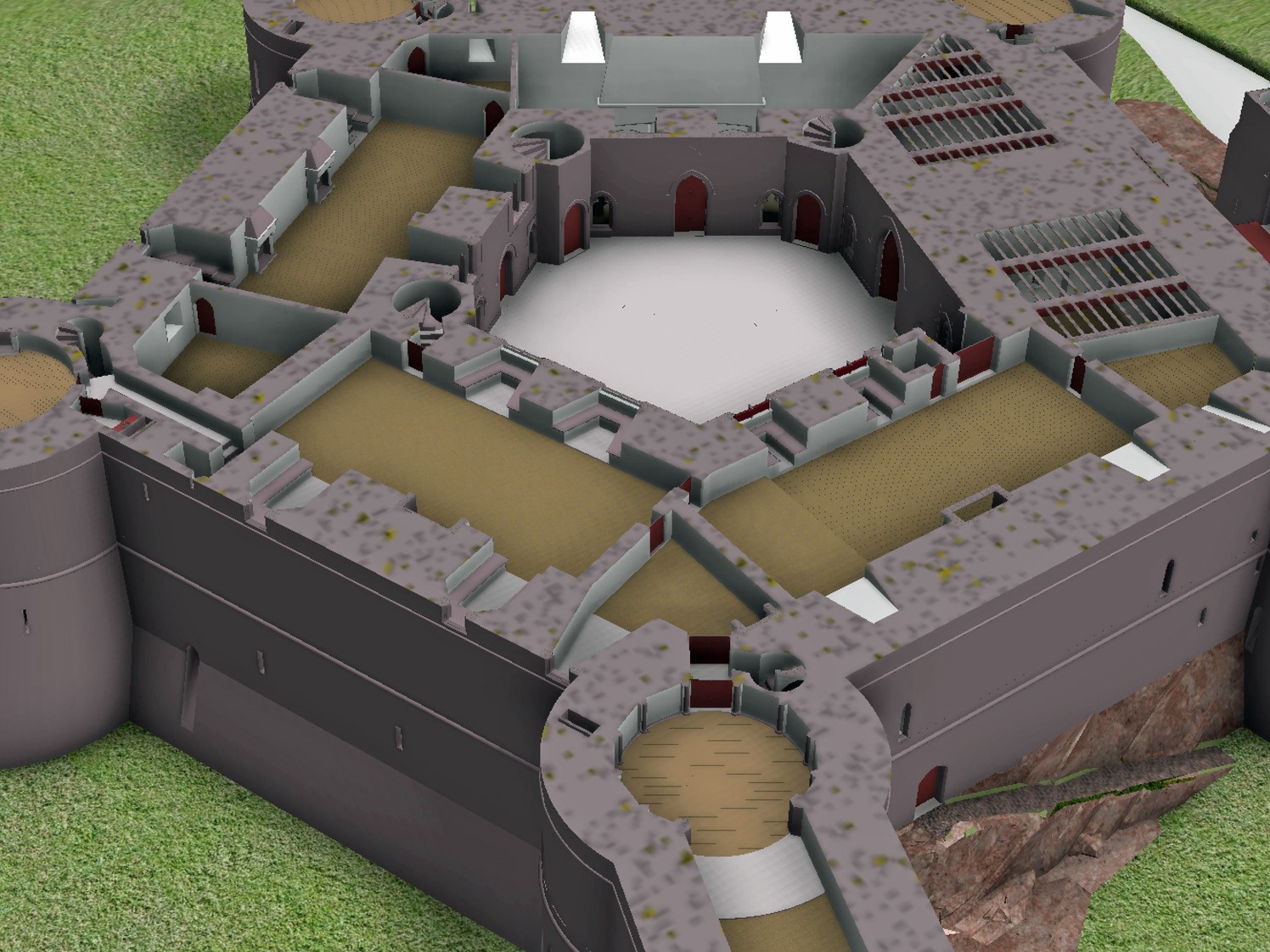
Holt First floor floor plan with with watergate to the fore and great hall and stable section to the right, copyright Chris Jones-Jenkins
The development of the model became an iterative process between the historian and the artist. Different combinations of layout and floor heights were tried, building on the fixed points surviving at basement level and rising up in an effort to accommodate all the rooms. Suites of accommodation began to emerge. Sir William Stanley’s great chamber led off the high end of the hall and controlled access in one direction to his counting house and the chapel, and in the other to the Treasure House and the High Wardrobe, where all the valuables were kept. Across the courtyard his wife, Elizabeth, had her own great and bed chamber, linked to the nursery. Above her accommodation was a chamber for her gentle women, well away from the yeomen’s dormitory under the lord’s great chamber. One range was dominated by the kitchen, rising the full height of the castle, connected at basement level to a larder, pastry house, well house and a wine cellar on one side and offices for the cook and butler on the other. As was normal the constable had a suite over the inner gate, but unusually a stable for 20 horses was created in a basement below the hall with access for the animals across the moat and up a ramp into the castle.
Holt Great Hall and Stables copyright Chris Jones-Jenkins
Working on this reconstruction, our admiration only grew for the original designer. He created a symmetrical plan and external appearance but produced complex internal arrangements to meet his patron’s needs. Holt is as much a chivalric ideal as a practical castle. An animation of the reconstruction of Holt Castle has been produced by Mint Motion of Cardiff and can be viewed here: