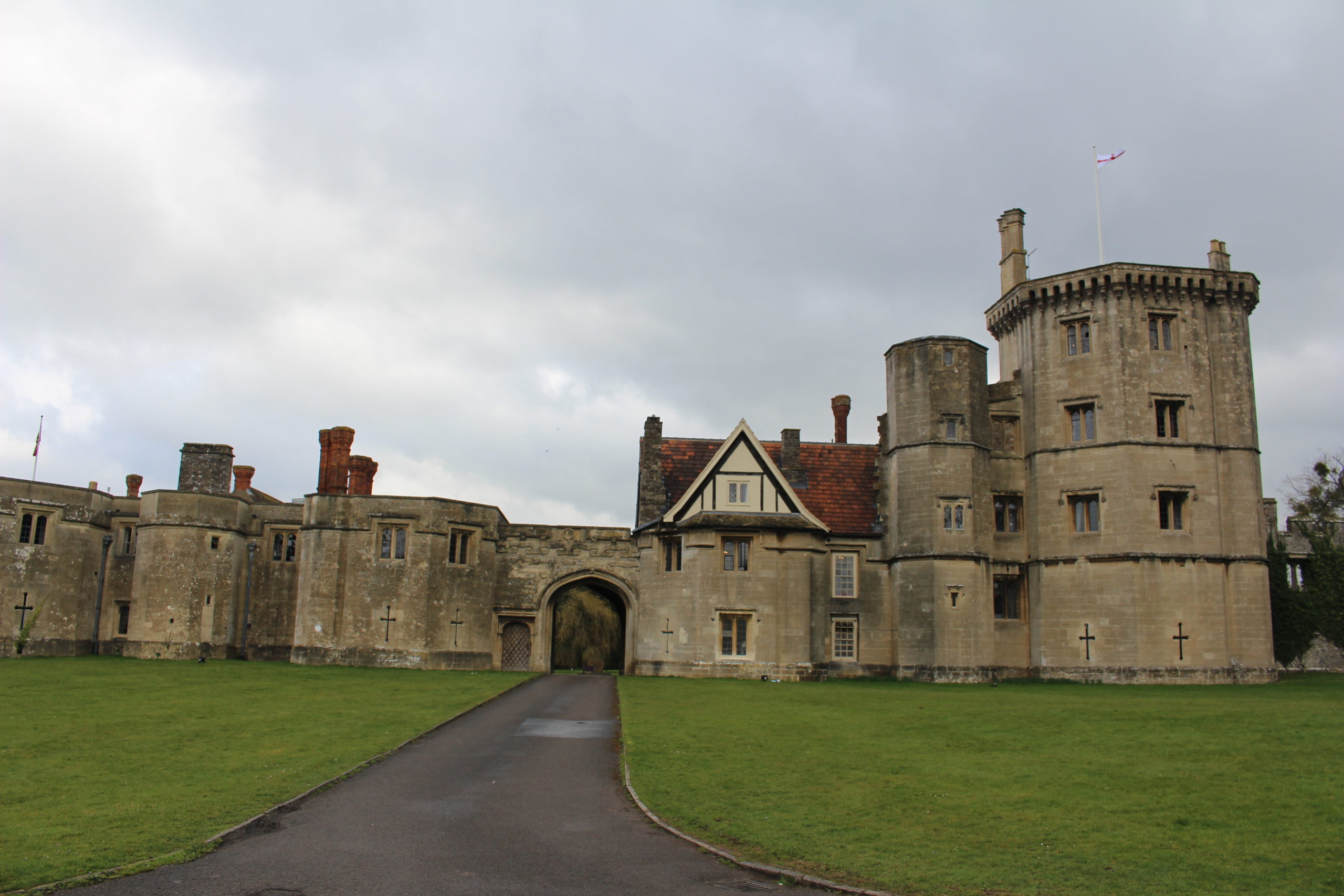
Bill Klemperer is the Principal Inspector of Ancient Monuments for Historic England – advising on aspects of national policy and casework around the country – especially the midlands where he is based in the Birmingham office. Here he talks about four important border fortresses he has helped save.
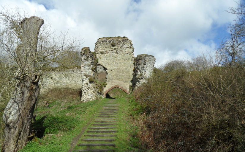
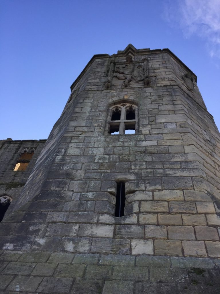
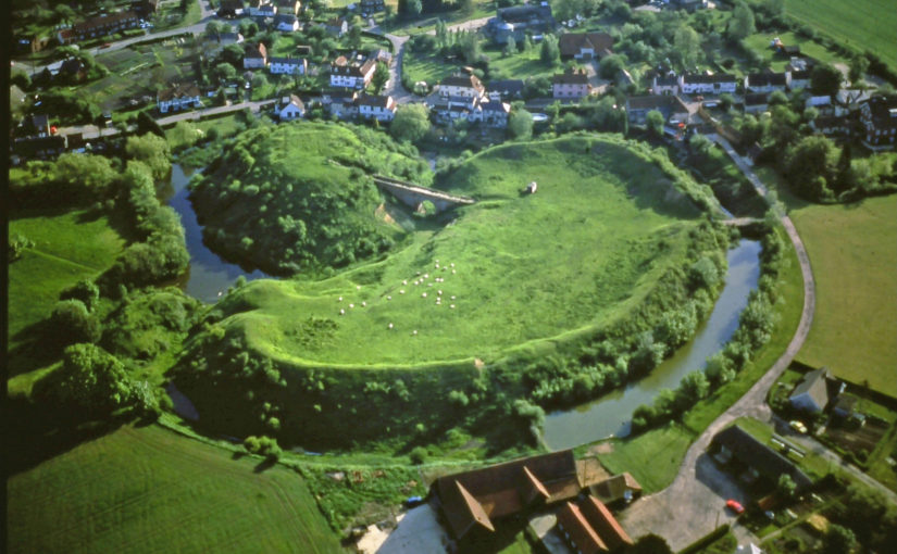
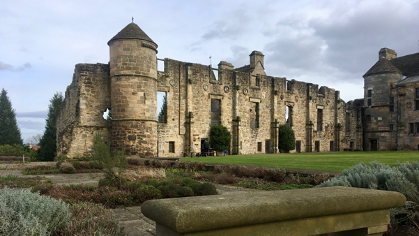
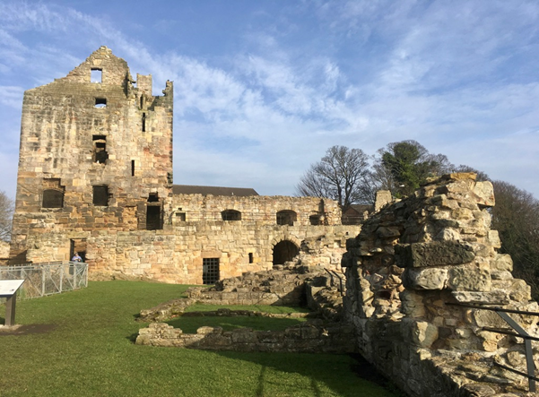
Altogether there are many hundreds of castles in the Welsh borders most of which are scheduled – protected by law under the 1979 ‘Ancient Monuments and Archaeological Areas Act, 1979’ and part of my job is to help look after them. One of my predecessors, the late Anthony Stretten, undertook a survey in the 1990s to identify those castles that would require most effort to save them for the future. A ‘top four’ emerged – all with significant stone buildings that required repairs – Wigmore Castle just west of the village in north Herefordshire, Hopton Castle in south Shropshire west of Leintwardine, Wilton castle on the River Wye at Ross-on-Wye, and Clifford castle further up the Wye just north of Hay-on-Wye. They have now all been repaired – but the solutions have been different in each case.
Wigmore. This was a case of state intervention. Following a collapse the then Secretary of State, Peter Walker, agreed to take the castle into public ownership – so it is now maintained by English Heritage as a free visitor destination. The ruinous state of the castle was an issue – with multi-phase buildings all higgledly-piggledy all over the place. Twenty years of careful excavation was going to cost too much and would have destroyed much of the later evidence in revealing the earlier phases. So a different approach was agreed – the walls would be consolidated as they were – and the site would retain its importance for flora and fauna – a stabilised place of wonder to be discovered and explored. This became the type site for ‘soft capping’ that now has become mainstream practice. The grass on the wall tops protects the walls from the weather and after twenty years is still doing a good job. Some limited archaeology was done to inform stabilising works,but these few trenches produced amazing findings – so do get the report to find out more
Wigmore Castle Excavation
Hopton castle. An impressive earthwork site with motte and bailey and later gardens and associated buildings are evident, and also the site of a nasty civil war massacre and siege. When I first saw it I was struck that the impressive tower of c.1300 that dominates the site could be abandoned in a field without access. A condition report revealed that the north west corner was about to fall off – but how to get the money to fix it? We talked to the locals and the Hopton Castle Preservation Trust was born. English Heritage funded a condition survey and work to prepare a lottery bid and the committee decided – by the Chair’s casting vote – to award about a million pounds! Archaeological ‘clearance’ followed and CBS Conservation came in to do the works. The Duke of Gloucester helicoptered in for the official opening. The site now has free access every day of the year and is secure for the future.
Hopton Castle Restoration – mini railway to clear rubble
Wilton Castle was done at about the same time as Hopton in the first decade of the millennium. Here the ‘White Knight’ solution came to the fore in the shape of owners Alan and Sue Parslow. Wilton is a multi-phase stone castle and much work was needed to repair the walls and towers. This was jointly funded by the Parslows and English Heritage. Various different conservation techniques were used – full roofs were put back on the north west and south west towers – the former complete with chimney found in the excavation of the basement! A ‘hidden’ lightweight modern roof put onto a large 13thC east tower. Gracile [DO YOU MEAN GRACEFUL?] walls were supported by buttresses in contrasting material, wall walks discovered and replaced, a section of curtain wall rebuilt, and decayed stone, including some lintels and cills replaced. The site is now safe and the owners have open days each year.
Wilton Castle Reconstruction Work
Clifford was the most recently repaired – and this came about when the site came into the new ownership of Keith and Ann Hill, who are also keen to care for the castle in their care. Historic England (as we became in 2015) gave a grant to help the owners repair the buildings on top of the motte and this was done by Treasures of Ludlow – a well-known firm of conservation builders. Archaeological interpretation of the buildings has been undertaken by Nigel Baker while the Castle Studies Trust funded a geophysical survey and excavations there too. Amongst the tightly packed stone buildings on the large flat-topped motte is the so-called Rosamund’s Tower. Rosamund Clifford – the ‘Rose of the World’ – was brought up at Clifford Castle, daughter of the Marcher Lord Walter de Clifford. She became the mistress of Henry II and died, still not 30 in 1176. The site with its large bailey containing remains of an interesting barbican can be visited by appointment with the owners.
Clifford Castle CST Excavation Study Day – chamber block on the mott
Much work has been done and much more remains to be done. The ‘local Trust model’ is achieving spectacular results at Snodhill castle near Peterchurch in Herefordshire’s Golden valley. Another notable success in recent years has been the repair of the rare shell keep at Kilpeck castle south of Hereford. All of these places are part of our shared inheritance Looking after them is our responsibility to future generations so they can share in that wonder.
William Wyeth, Properties Historian at English Heritage Trust and project lead on the Castle Studies Trust funded project to geophysically survey Warkworth Castle explains what he hopes the survey will achieve.
In 2019 English Heritage, a charity which looks after over 400 historic properties and sites across England, began a project to change the way in which the stories of the people and buildings at Warkworth Castle in Northumberland were told. The castle is a popular destination in the county, and is both connected with notorious figures from the past as well as featuring an iconic piece of medieval architecture and design in its late 14th-century Great Tower.
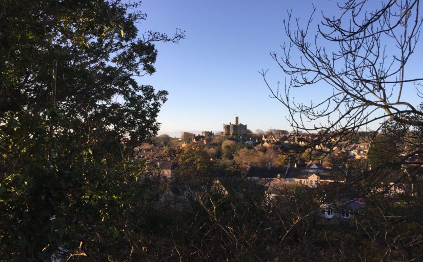
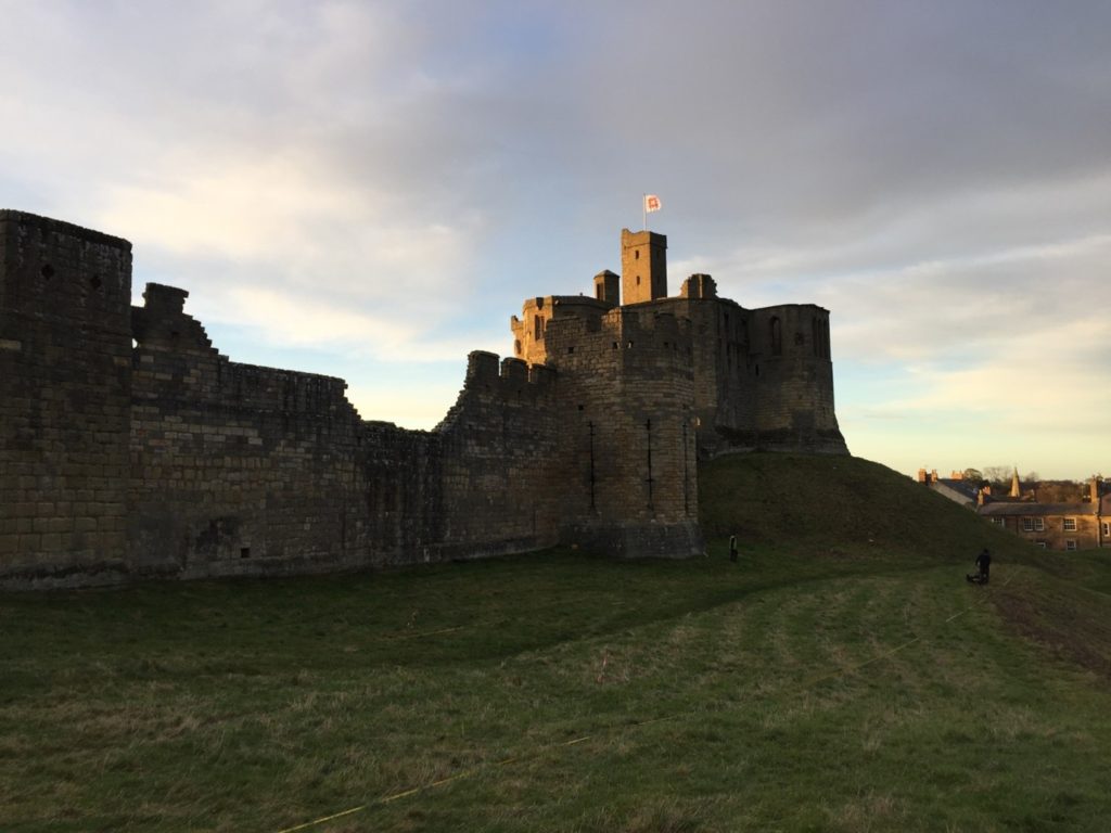
Figure 1. Warkworth Castle from the south-east. The Great Tower, in the background, sits atop a large motte. In the foreground, the curtain wall is punctuated by the Grey Mare’s Tail tower. Archaeologists from Archaeological Services – Durham University are surveying the unenclosed strip of bailey
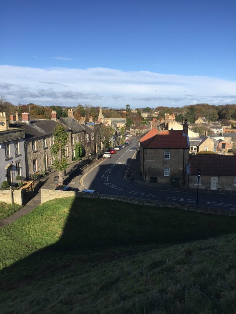
Warkworth is located at the foot of a narrow loop in the River Coquet, in coastal north-eastern Northumberland, about 25 miles north of Newcastle-Upon-Tyne and 30 miles south of Berwick-Upon-Tweed, themselves both significant fixtures of the late medieval history of this area. Just north of the castle proper and nestled on three sides within the river loop is the small village of Warkworth, arrayed in quite typical medieval layout. At the north end of the high street, sitting on a rough north-south axis, is the parish church of St Lawrence, probably an early medieval foundation, as well as a bridge with a toll-collecting tower built in the later 14th century. South of the church, numerous narrow parallel plots of land spread out at right angles from the high street. The southern trajectory of the street is abruptly broken by the enormous motte (earthen mound) of the castle, which acts to physically separate the village from the land south of the river.
Among the most famous historical figures connected to the castle was Henry Percy, eldest son of the 1st Earl of Northumberland, though he is more familiar to us today as Harry Hotspur. The origin of his martial nickname is not certain, but is accounted for in several traditions, all of which confirm that they drew from his short-tempered and violent character. One later 16th-century source rhythmically noted “For his sharp quickness and speediness at need / Henry Hotspur he was called in very deed.”
Though the early history of the Percy Northumberland earls and associated figures will form a key part of the story of the castle when the interpretation project is completed in 2022, other questions about the castle, and especially its earlier history, remain as yet unresolved. Among these is the relationship of the earthworks – the motte and bailey – with the stone structures atop them, the oldest of which date to the later 12th century. The Castle Studies Trust has graciously agreed to fund a geophysical survey of much of the castle earthworks to resolve three big questions.
The first touches upon the motte, which features the Great Tower of the 1370s, but was probably topped by an earlier structure. By assessing buried deposits around the tower, we aim to reveal traces of this earlier structure. But we also want to establish evidence for the means by which the Great Tower may have been provisioned, via a secure door to the motte-top outside the enclosing curtain wall which gave access to storage areas for beer and food in the tower’s north-west segment.
The second question relates to the bailey. In common with other castles of this type, the bailey was filled with buildings, often (as at Warkworth) in their earliest phases arrayed along the inner face of the enclosing wall. But were there buildings here before, or were there also buildings here from later periods, but for which above-ground evidence has been lost? Findings from the survey here will greatly influence how we understand the formal approach to the bailey’s principal buildings – its Gatehouse, Great Hall and Chapel – but also the late medieval Great Tower. The results may also shed light on the peculiar overhauling of spatial arrangements in the bailey occasioned by the construction of a 15th-century Collegiate Church which straddled the span of the bailey, arguably fundamentally changing how the castle was to be experienced.
The last question also relates to the bailey, but here to a strip of the bailey which sits outside the embrace of the late 12th-early 13th-century stone curtain wall, on the eastern side of the castle. The omission of this area from enclosure is unusual, though it is not without analogies from elsewhere, which suggest areas like this could contain gardens. It may be instructive that just within the bailey and adjacent to this strip was the location of late medieval stables – perhaps this area came to be used for the grazing of horses, though whether this was its original intended purpose remains to be seen. In addition to all of this, however, is the possibility that when the motte-and-bailey was built, perhaps well before the earliest stone parts of the castle were erected, the earliest enclosing wall of the bailey also embraced this eastern strip, thereby creating a larger bailey than the present one.
We hope that the survey will allow us to answer at least some of these questions. Whatever the outcome, it is certain that the results will help change how we understand the story of Warkworth Castle and its previous inhabitants.
Heidi Richards, doctoral research at Durham University, looks at Pendragon Castle and how medieval romance literature impacted later medieval castle building.
Since childhood, I’ve been fascinated by castle ruins, stories of King Arthur, and a golden age of chivalry that existed somewhere back in time between history and fantasy. Fast-forward twenty years, and I’m currently finishing my doctoral thesis looking at the impacts medieval romance literature had on late medieval English castles.
Former arguments in castle studies subjected castles into a martial vs. status dichotomy, but current research embraces the duality of these aspects of the castle, providing space to explore possible symbolisms built into castle architecture and wider landscapes.
My research explores the importance of romance literature and legend within medieval society’s most elite, and through wills, commissions, dedications, and gifts, we find that romances were highly valued. Of primary importance though, was Geoffrey of Monmouth’s (c.1138) Historia Regum Britanniae (History of the Kings of Britain). While not technically a romance, this work brought legendary heroes into an ancestral pseudo-history of the kings of Britain (including Constantine and King Arthur) and provided source material for romance narratives and characters. Many members of the elite alluded to this highly prestigious “ancestry” to legitimize and justify power, especially within the political propaganda and ambitions of Edward I.
Edward I was indeed an Arthurian “enthusiast” (as he has been called in previous research). He hosted many “Round Table tournaments” (more theatrical than regular tournaments and usually included Arthurian role-playing) to celebrate significant events, such as his Welsh victory in 1284. He exploited his “Arthurian ancestry” in a grand ceremony at Glastonbury Abbey in 1278 to reinter Arthur and Guinevere’s bodies—essentially conducting a spectacular funeral for Arthur, during which he used “Arthurian” relics (including Arthur’s crown) to legitimize his “inherited” power. He also wrote a letter to Pope Boniface in 1301 to claim land in Scotland on the basis that it was once owned by his ancestor, Arthur. A grand feast was also held at Westminster in 1306, during which Edward I swore oaths on a swan, in typical romance style, and knighted Edward II along with 267 others.
Every effort was made to continue Edward I’s Arthurian prestige and chivalric legacy when Edward II succeeded the throne. On his deathbed, Edward I charged his closest barons with assisting Edward II as his reign began; one of whom was Robert Clifford, who organized an enormous, chivalric celebration for Edward II’s coronation in 1308.
Edward II soon began to show that he was not the chivalric king his father was, staunchly contradicting the values of Edward I’s chivalric legacy. Records claim that he enjoyed working in the garden (which was uncustomary and inappropriate for a king), he didn’t like hunting, he didn’t participate in tournaments, and he thoroughly annoyed the barons with his infatuation over Piers Gaveston. As baronial unrest and tensions increased, we begin to see Arthurian allusions made by Edward II’s principal opponents—the same ones closest to Edward I.
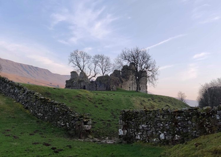
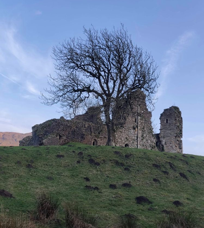
This brings us to Pendragon Castle (Cumbria, previously Westmoreland), inherited by Robert Clifford as the “castle of Mallerstang,” along with other nearby castles, including Brough, Brougham, and Appleby. Clifford renovated Brougham and Pendragon Castles in preparation to host Edward I during the Anglo-Scottish wars in 1300, but whilst his other castles were renovated in contemporary architectural styles, Pendragon retained its archaic image. Architectural archaism was a trend in castle construction, used to symbolise continuation of power and ancestral prestige. In 1309, Clifford was granted a license to crenellate, changing the “castle of Mallerstang’s” name to Pendragon Castle.
Pendragon Castle (from the moat), photo by Heidi Richards
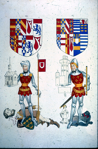
In 1312, Guy Beauchamp, 10th Earl of Warwick, presided over the trial of Piers Gaveston, whose greatest crime, according to the commemorative Warwick ancestral “Rous Roll” (c.1484), was stealing King Arthur’s round table. The Earls of Warwick already had long-standing connections with Arthur and displayed romantic “relics” inherited from their “ancestors.” Robert Clifford and Thomas Lancaster also participated in Gaveston’s trial and execution, and in 1322, Lancaster signed a treasonous document to James Douglas in Scotland under the pseudonym “King Arthur.” In 1327 and 1328, Roger Mortimer, the lover of Edward II’s queen, Isabella, celebrated the marriages of his children by hosting multiple Arthurian themed Round Table tournaments in the style of Edward I, each lasting several days and sparing no expense.
Image S-42-23 from The Heraldry Society 1845 edition of the Rous Roll, images 46 (left) showing Guy Beauchamp, 10th Earl of Warwick standing over the executed Piers Gaveston, and 47(right) shows his son, Thomas, portrayed with silver cup—heirloom relic of the fictional Swan Knight. The c.1484 original (British Library MS 48976), includes a caption below Guy’s image accusing Gaveston of selling “out of the land the round table of silver that was King Arthur’s and the trestles…” Link to Guy Beauchamp’s image in the Rous Roll (c.1484) British Library MS 48976 https://imagesonline.bl.uk/asset/143267
In the wake of Edward I’s chivalric legacy, those who were closest to him (including Clifford, Warwick, Lancaster, and Mortimer) developed ways to emulate Arthurian prestige in their opposition to Edward II, and it is within this context that Pendragon Castle comes into view as one of several homages to King Arthur, Edward I, and the not-so-distant golden age of chivalry.
Since the publication of the article on Pleshey Castle in Current Archaeology (Issue 344, Nov. 2018, CST blog 15/09/20), we have been able to reconstruct in detail the gatehouse of the timber bridge over the motte moat, whose upper chamber is identified from building accounts for 1460-1 as the Queen’s privy chamber (‘Q’ on Fig.1). It would have been occupied by Queen Margaret of Anjou, wife of Henry VI, who held Pleshey between 1445 and 1461. Pottery dating, documentary evidence and the style of the floor tiles, however, suggest that the gatehouse was built in the 1380s by Thomas of Woodstock, duke of Gloucester, and the upper chamber would originally have been occupied by his wife, the duchess Eleanor. In the late medieval period, it was usual for accommodation to be provided above gateways. This gatehouse at Pleshey closed off the keep and the lord’s private quarters from the rest of the castle, but although it would have provided a degree of security it should not be confused with the heavily fortified gateways of castles with a more obviously military role.
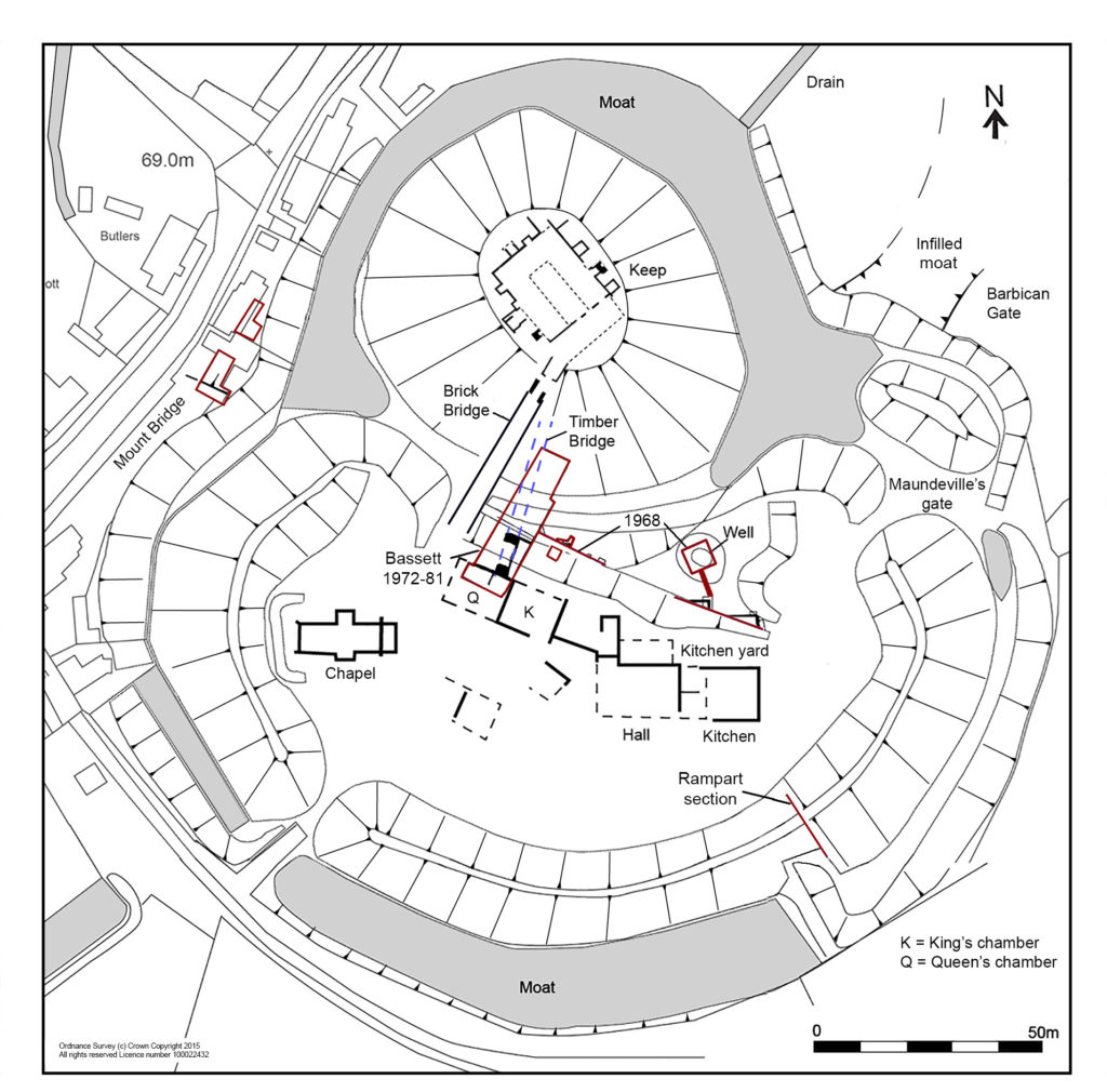
FIGURE 1: Plan of the castle, with the queen’s chamber over the bridge gatehouse (Q) and the king’s chamber (K) immediately to its east, with the line of the timber bridge shown in blue. (Drawn by Iain Bell).
The physical character of the gatehouse can be reconstructed from specialist building material reports by David Andrews, Paul Drury and Nick Wickenden. The gatehouse was built of flint, with greensand dressings for the foundation plinth, corner stones, and door and window mouldings, with a peg-tile roof and lead gutters. Together with the chapel and the keep (which was timber but had a stone façade) it was one of the few stone buildings in the castle, as even the great hall in the bailey was of timber on stone sleeper walls. The ground floor room next to the gateway had a simple gravel floor and was probably a guardroom, but the upper chamber was luxurious. Its floor was of decorated glazed tiles made at Penn in Buckinghamshire, with three different roundel patterns (Fig. 2). Fragments of glass and lead cames show that the chamber had leaded glazed windows, while part of a chimney pot found in a spread of demolished roof tile implies that it was heated by a fireplace. The walls were plastered and decorated with simple painted designs, rather like modern wallpaper.
Three designs of Penn decorated tile floors as reconstructed by Paul Drury, based on tiles found in the demolition rubble of the bridge gatehouse. (Drawn by the Drury McPherson Partnership).
The chamber would have been dominated by a large four-poster bed with richly embroidered silk or fine wool hangings for curtains around it, as well as the tester for its canopy and the valence at its base. Several sets of these hangings are described in an inventory of goods seized from the castle following Thomas of Gloucester’s arrest and murder in 1397 (Dillon and Hope 1897). The chamber may have had tapestry wall hangings, also described in the inventory. The carpets that are mentioned would have been more like rugs and most of the decorated floor would have remained uncovered.
There was a general improvement in the private living quarters in the castle in the late 14th century, especially with the addition of fireplaces and privies. In the 1450s, when Pleshey was held by Queen Margaret of Anjou, the building accounts suggest that the keep had become guest accommodation, with the Queen’s chamber in the gatehouse and the King’s chamber next to it, approached by a ‘revealing’ or audience chamber (‘Q’ and ‘K’ on Fig. 1; Ryan 2010, 252). Queen Margaret would have been an absentee landlord as she spent most of her time at court, but these chambers would have been prepared for occasional visits. One such visit probably occurred when she ordered major building works at Pleshey early in 1458. After the defeat of the Lancastrians in 1461 Pleshey passed to the Yorkist Edward IV and, from 1465, Queen Elizabeth Woodville. Several entries in the building accounts for the 1460s record cleaning and refurbishment work before royal visits, and the gatehouse accommodation would still have been of a high standard, fit for a queen, eighty or so years after it was built.
Dillon, Viscount and Hope W.H.St.J. 1897, ‘Inventory of the goods and chattels belonging to Thomas, Duke of Gloucester and seized in the castle at Pleshey, Co. Essex, 21 Richard II (1397); with their value as show in the escheator’s accounts’, Archaeol. J., 54, 275-308 (transcript from PRO E 136/77/4): Available:
Amidst the tower blocks and industrial landscape of Kirkaldy in Fife is an unexpected sight. Perched on a triangular promontory overlooking the Firth of Forth stands the crumbling ruin of a fifteenth-century fortress. Now fiercely guarded by an abundance of resident seabirds, Ravenscraig is one of Scotland’s lesser-known medieval castles, yet it deserves a closer look, not least because it is a rare surviving example of a castle commissioned by a woman, in this case Mary of Guelders, queen of Scotland (d.1463).
Mary of Guelders and James II
Mary of Guelders first arrived in Scotland on the 18th June 1449 when she stepped onto the shores of Leith ahead of her marriage to James II at Holyrood Palace. Born in Guelders (today the province of Gelderland in Holland) and raised at the Burgundian court, Mary brought illustrious connections to her new home. The match, it seems, was met with approval on both sides: in 1457, Mary’s uncle the Duke of Burgundy sent James the gift of Mons Meg, the famous cannon which can still be seen at Edinburgh Castle today. James’ love of artillery, however, was to also be his downfall. Three years later at the Siege of Roxburgh the 29-year-old king met an untimely end when another of his cannons exploded and killed him. Mary, as this previous blog post has shown, was present at the siege, and following her husband’s tragic death, the newly widowed queen ordered for Roxburgh to be razed to the ground. From 1460 until her own death three years later, Mary acted as regent of Scotland, ruling on behalf of her young son, James III. It is also from this point that she becomes visible to us in the historical record as a prolific patron of architecture.
Mons Meg, Edinburgh Castle. Photo by Lee Sie, licensed CC-BY-SA 2.0.
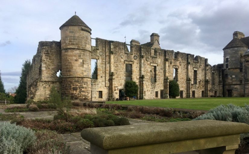
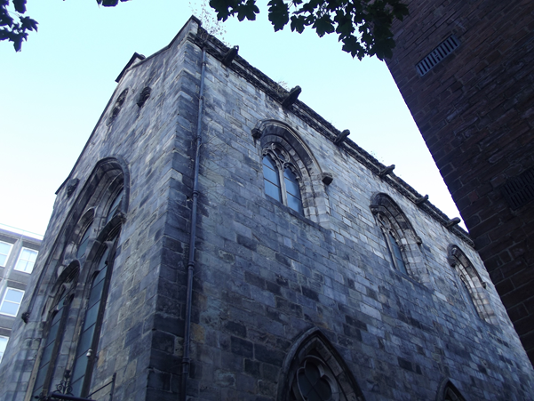
The nature of the evidence means that we don’t know too much about Mary’s actions during her marriage, but the few glimpses we can glean suggest that she played a relatively active role as consort, including at her husband’s first parliament in 1450. She was also present at the siege of Blackness Castle in 1454 (which James afterwards gave her as a gift to celebrate the Scots’ victory), and she appears to have been the driving force behind the couple’s foundation of a hospital at Fale near Glasgow. It is during her brief stint as regent, however, that Mary’s enthusiasm for building projects really becomes apparent: she not only commissioned Ravenscraig, but also Trinity College Kirk in Edinburgh, as well as improvements to Falkland Palace, which included the first recorded instance of a gallery in Scotland. Recent dendrochronology carried out by Dr Coralie Mills and Hamish Darrah on the tower of St Giles’ Cathedral in Edinburgh on behalf of Historic Environment Scotland has also revealed Mary’s likely involvement in the fifteenth-century alterations there. Ravenscraig was therefore one of a number of works which Mary undertook during her regency.
Shortly before his death, James II had gifted the estate of Dysart to Mary, after which she funded her major works at Ravenscraig entirely from her own revenues. We know from the Exchequer Rolls that she spent 600 pounds Scots on the castle, but it could have been considerably more, as the accounts of the queen’s lands for the first term after the king’s death are missing. Building began in the east, but Mary died before she could see the castle finished, at which point the regular flurry of works ceased altogether. Part of the castle was inhabitable before her death, however, as in 1461, the queen’s steward was able to stay there for 25 days along with several of her servants.
From the outset, Ravenscraig appears to have been intended to have a strong military appearance and is believed to be the first castle in Scotland designed to withstand cannon fire. For this reason, it has been treated as something of an enigma by historians and heritage professionals, who often regard the military design as being at odds with its supposedly intended use by Mary as a dower or “retirement’’ house. Yet the two are not necessarily incompatible. Mary’s decision to fortify the castle and to protect a vulnerable piece of coastline made perfect sense given the changeable nature of relations with the English at this point.
It was also not unusual for women elsewhere in Europe to be involved in military endeavours at this time. Mary’s contemporaries in Renaissance Italy, for example, frequently acted as military managers, fortifying towns and cities and supplying provisions and resources. Closer to home, Margaret of Anjou, with whom Mary negotiated terms in 1460, was also commissioning works on several English castles around this time, including the refurbishment of the keep of Pleshey Castle in brick. Equally, Mary’s aunt, Isabella of Portugal, in whose court the queen of Scots had been raised, was a politically active and energetic architectural patron. Mary therefore came from a tradition whereby architecture was commonly adopted as a language of female power. It is also possible, particularly given the circumstances of James’ death, that Mary intended for Ravenscraig to be part of a larger commemoration project for her husband, which also included her mausoleum at Trinity College Kirk in Edinburgh.
The termination of the works at Ravenscraig upon Mary’s death in 1463 suggests that she was very much the driving force behind them. James III showed little interest in his mother’s project, instead granting the castle to the Sinclair family, who completed the building. Nevertheless, the remains stand as a testament to the ways in which Mary chose to materially express her authority as regent. They also pose a challenge to the overwhelmingly male narrative that has long dominated castle studies, reminding us that women could, and did, play active and sometimes innovative roles in shaping the physical and social life of late medieval castles.
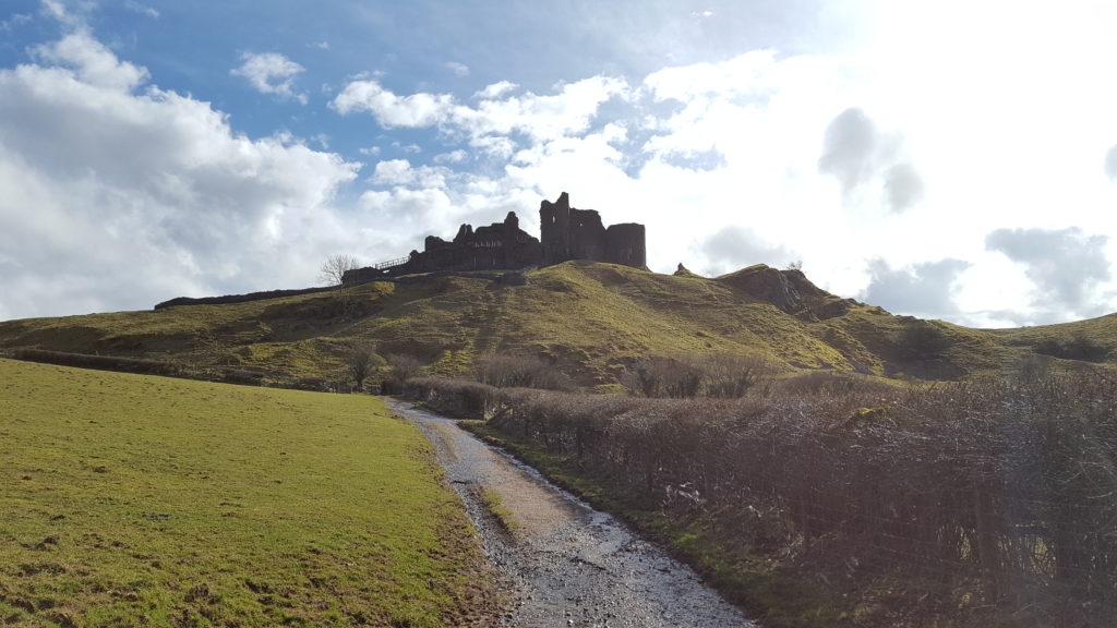
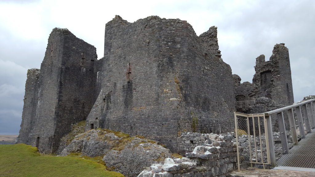
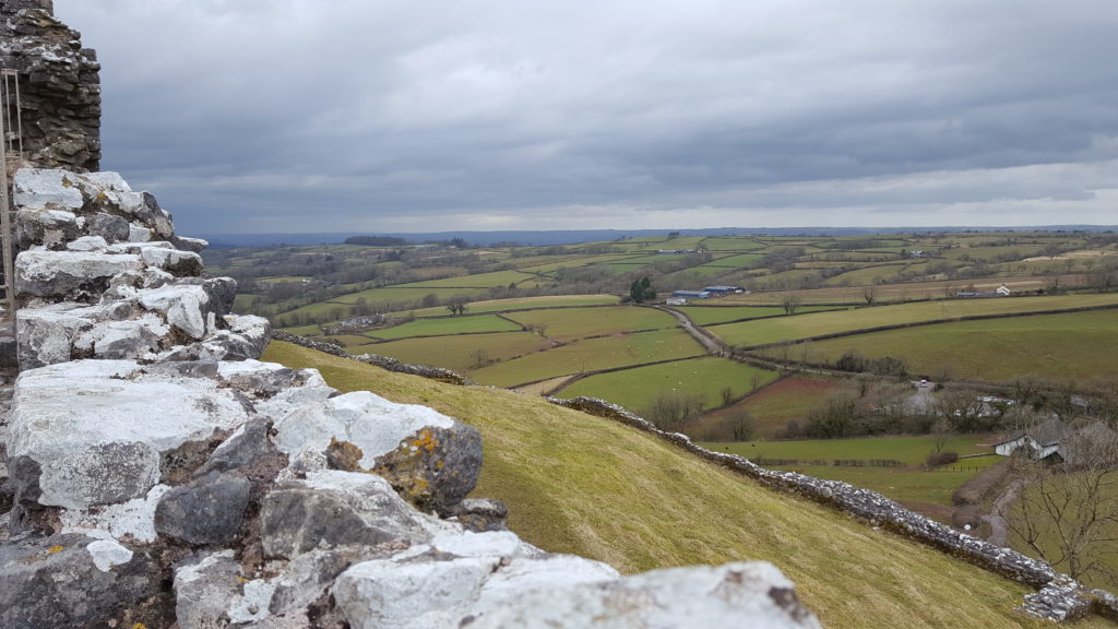
The striking ruins of Carreg Cennen Castle in south Wales have a rich history, bound up in power struggles between the Welsh and English and the Wars of the Roses. Dr. Dan Spencer takes us on a journey through its past.
Carreg Cennen was most probably founded by the Welsh prince of Deheubarth, Rhys ap Gruffydd, in the late twelfth century. It is situated in a prominent position on a high limestone crag overlooking the River Cennen. Carreg Cennen was later captured by the English during the conquest of north Wales in the late thirteenth century. Edward I granted the castle to John Giffard, Lord Giffard of Brimpsfield, who extensively rebuilt the castle. Carreg Cennen was acquired by Henry, duke of Lancaster, in 1340, and thereafter by marriage to his son-in-law, John of Gaunt, duke of Lancaster, son of Edward III. The duchy of Lancaster subsequently passed into royal ownership, upon the accession of Henry IV, Gaunt’s eldest son, to the throne in 1399. Carreg Cennen was captured by the rebels of Owain Glyn Dŵr in the early fifteenth century, with repairs carried out during the reign of Henry V.1
In 1455, Welsh landowner Gruffydd ap Nicolas seized the castle, taking advantage of a power vacuum in south Wales, where many of the principal royal offices were held by absentee officials. This move was not welcomed by the government of Henry VI. Gruffydd subsequently came into conflict with Edmund Tudor, earl of Richmond, a half-brother of the king, in the following year. Richmond eventually emerged victorious from the struggle in the late summer of 1456, at which time it appears that Gruffydd relinquished control of Carreg Cennen.2 The earl died of the plague later that year, with the task of maintaining royal authority in southern Wales thereafter entrusted to his brother, Jasper Tudor, earl of Pembroke.
In 1459, civil war broke out when the Yorkist lords, Richard, duke of York, Richard Neville, earl of Salisbury, and his son Richard Neville, earl of Warwick, attempted to seize power. This development prompted Jasper to install a garrison in the castle, which remained in place until at least the following year.3 It is not known how large the garrison was, and Carreg Cennen appears not to have seen any military action at this time. This is not surprising, as potential attackers would have been deterred by its strong defences. It was also in a relatively isolated location, far removed from the main areas of conflict.
Instead the fate of Carreg Cennen was decided by events elsewhere. The decisive clash of the conflict took place at the Battle of the Towton on 29 March 1461, the largest engagement of the Wars of the Roses. The Yorkists led by Edward IV were victorious, with Henry VI and his remaining supporters forced to take refuge in Scotland. Later that summer, Edward delegated the task of subduing Wales to some of his trusted supporters, who included William, Lord Herbert.4
By the end of 1461, the Yorkist commanders had succeeded in conquering almost all of Wales (with the main exception of Harlech in the north-west), and Jasper Tudor fled overseas. This left Carreg Cennen as the last remaining Lancastrian fortress in the south. In the spring of 1462, Lord Herbert instructed his half-brother, Sir Richard Herbert, and another member of the gentry, Sir Roger Vaughan, to take control of the castle. They set off from Raglan Castle, Herbert’s ancestral seat, with a force of 200 gentlemen and yeomen and soon reached Carreg Cennen. The defence of the latter was led by Thomas and Owen ap Gruffydd, sons of the recently deceased Gruffydd ap Nicolas. It is unclear whether they had been given this responsibility by Jasper Tudor, or if they had exploited the situation to take control of the castle. Either way, the brothers were said to have a large force under their command and had a strong defensive position. Nevertheless, the futility of the Lancastrian cause prompted them to surrender under terms. They were pardoned in return for pledging allegiance to Edward IV.5
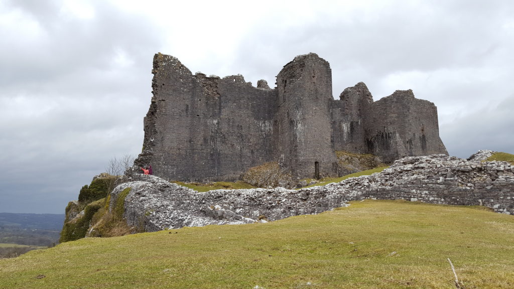
On Lord Herbert’s instructions, the castle was provisioned, and a garrison was installed for its safeguard. This consisted of a small force of nine men, who served there from the beginning of May until mid-August. These men each received 4d. per day in wages, the standard rate for footmen or archers at this time, as well as 1s. 10d each per week to pay for their expenses.6 The garrison was required, as is explained in a surviving letter from Edward IV, because ‘the said castle was of such strength that all the misgoverned men of that country there intended to have inhabited the same castle and to have lived by robbery and spoiling our people of the country’. However, as the letter went on to explain ‘we soon after were advised that the said castle should be thrown down and destroyed’ to avoid the inconvenience of expending money on maintaining its defence. The source of this advice is unspecified, but it could have been from Lord Herbert, who, as chamberlain of south Wales, was acutely aware of the financial burden of paying for its garrison. This was an extraordinary decision, as no other castle was slighted by royal command at this time, which may have reflected Yorkist concerns about its potential as a formidable fortress in an area with Lancastrian sympathies. It could also have stemmed from more general unease about law and order in the region. The king therefore issued orders to Herbert to oversee its destruction. A labour force of 500 men was recruited who used a variety of tools to ‘break and throw down’ the castle.7 The extent of the destruction is unclear, but at the very least the labourers made the place uninhabitable, with Carreg Cennen thereafter falling into ruin.
[1] J. M. Lewis, Carreg Cennen (Cardiff: Cadw, 2016), p 1; H. M. Colvin, The History of the King’s Works, volume 2 (London: H.M.S.O, 1963), p. 602.
[2] For Gruffydd’s seizure of the castle and conflict with Edmund Tudor see, William Rees, ed., Calendar of Ancient Petitions relating to Wales (Cardiff: University of Wales Press, 1975), pp. 184-6; PL, I, pp. 392-3.
[3] For the garrisoning of Carreg Cennen by Jasper see, TNA, DL 29/584/9249; DL 29/596/9558.
[4] For an overview of these events see, Anthony Goodman, The Wars of the Roses (London: Routledge & Kegan Paul, 1991).
[5]. For the occupation of the castle by the sons of Gruffydd ap Nicolas and its surrender see, TNA, SC 6/1224/6; SC 6/1224/7.
[6] TNA, SC 6/1224/6.
[7] Quoted from TNA, SC 6/1224/7, whose Middle English text has been modernised.
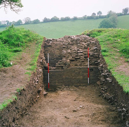
Shrewsbury Castle Excavation Director, Dr Nigel Baker, reviews the second season of excavations at the castle which has just ended, with an unexpected conclusion.
Shrewsbury Castle has sometimes been described (most often by the writer of this blog!) as one of the best-preserved shire town motte-and-bailey castles in the west of England. This remains true – at least in the sense that it has never been quarried away for gravel, nor had a prison or law courts built on top of it, nor was it demolished and redeveloped after the Civil War. Nevertheless, such a statement now requires a hefty footnote.
A visitor, walking into the inner bailey at the foot of the motte sees crenelated curtain walls rising from the top of substantial ramparts: the impression of a classic castle sequence with earth-and-timber fortifications renewed in stone, is overwhelming. The 2020 work has however shown that neither the ramparts nor the western curtain walls are quite what they seem. Excavation to a depth of more than two metres in the western rampart has shown that at least half of its height was a product of the post-medieval centuries – with a substantial contribution probably made by Thomas Telford during his ‘restoration’ of the castle in 1786-90, enhanced by his simultaneous lowering of the ground level across the interior.
Shrewsbury Castle excavation trench in western rampartas viewed fromfrom C13 logis block. Courtesy of Nigel Baker
But the medieval strata below Telford’s rubble also show that the western curtain wall, and by implication the standing castle building, the camera regis of the later 1230s, can no longer be seen as simple improvements to the original earthwork castle as the ground beneath them was found to drop away sharply, the slope levelled up by a massive medieval earthmoving operation. It seems that the present outline of the castle – and the familiar view of it from the railway station below, are a product of the early 13th century (dating subject to confirmation when the pottery has been analysed) – dubbed Shrewsbury Castle 2 by the excavators. The ‘original’ motte-and-bailey, first heard of when it resisted a siege in 1069, must have had a perimeter that was around 25% smaller, confined to the original hilltop. This castle (inevitably ‘Shrewsbury Castle 1’) was nevertheless heavily fortified, as the substantial motte ditch found in 2019 shows. As originally conceived, the ‘inner bailey’ was little more than a lobe-shaped barbican, protecting access up onto the motte, with little room for buildings within it. One of the implications of this is that the most important buildings – like the royal hall – must have been on the motte top.
The medieval landfill operation is also of interest on account of the rubbish contained in its strata. Preliminary visual identification of the animal bones suggests that game species are present, possibly pike, possibly swan, and it is likely that further work on this material will add to the growing corpus of evidence for high-status diet on castle sites throughout the region.
The excavation was funded by the Castle Studies Trust and supported by University Centre Shrewsbury under Professor Tim Jenkins and Dr Morn Capper. Archaeological direction was by Dr Nigel Baker and Dai Williams and the work was undertaken by local volunteers and UCS postgraduates and undergraduates.
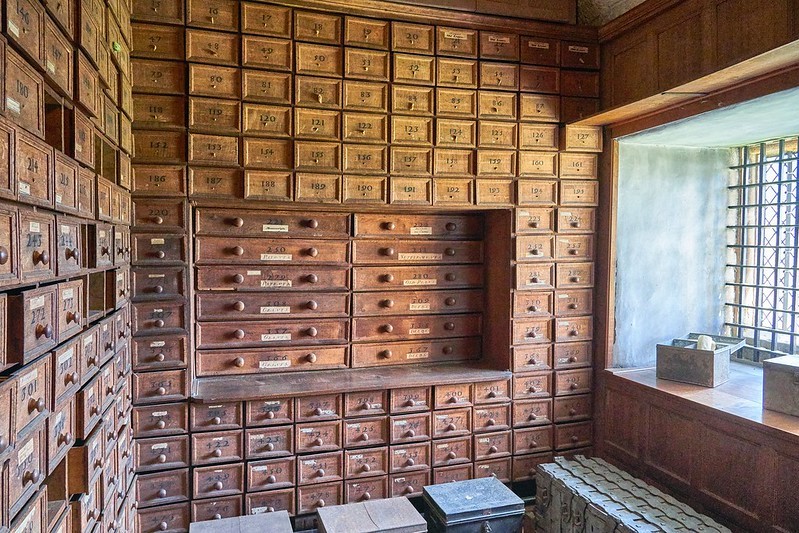
Anyone interested in the study of the past knows the importance of records and documents for information gathering. Records and proper documentation are not just important for historians, but they played a central role in the everyday management of a medieval and early modern landowner too. Creating and maintaining accurate records was only half the battle. They needed to be kept safe and easily accessible for the landlord or estate managers. By the sixteenth century, most documentation was being stored in muniments chambers in elite residences. Royal castles and residences had muniments chambers for centuries and it started to permeate into the nobility and gentry as they began needing their own documentation close at hand. Below is an image from Hardwick Hall of the muniments chamber of Bess of Hardwick. Spaces could be large and purpose-built, like the chamber below, or a series of chests that could be locked.
By the late sixteenth century, muniments chambers were a necessity in any high-status house. The nature of these spaces is conveyed by Richard Braithwait’s (1588-1673) prescriptions that an earl ‘have in his house a chamber very stronge and close, the walls should be of stone or bricke, the dore should be overplated with iron, the better to defend it from danger of fire’.[1] For Braithwait, the bulk of documentation related to landownership demonstrating the connection between documents and lordship. The documents needed to be kept orderly with ‘drawing boxes, shelves, and standards…and upon every drawing box is to be written the name of the Mannor or Lordship, the Evidence whereof that box doth containe’.[2] His advice continues to help with the ease of retrieving the documents:
and looke what Letters, Patents, Charters, Deeds, Feofements, or others writings, or Fines, are in every box; a paper role is to be made in the saide box, wherin is to be sett downe every severall deede or writing, that when the Earle, or any for him, hath occasion to make search for any Evidence or writing, he may see by that Role, whether the same be in that box or not.[3]
The level of organisational procedure that Braithwait discussed concerning muniments rooms is a clear indication to their increasing use by the end of the sixteenth century. Moreover, the space itself needed to be practical and secure.
Do we actually have any evidence that Braithwait’s description is accurate or was this a pipe dream? Nearly a century before Braithwait’s publication we have evidence of a well-organised muniments chamber at Thornbury Castle, Gloucestershire used to store the documentation of Edward Stafford, third duke of Buckingham (1478-1521). Buckingham’s son, Henry Lord Stafford, transcribed a list of manuscripts that were in the duke’s possession shortly before the duke’s execution (British Library, Add. MS 36542). The list describes the contents of six large chests. The chests bore alphabetical lettering on them, and Carole Rawcliffe has suggested that the duke had developed a simple, but effective organisational system for his documents. Each of the six chests recorded in Lord Stafford’s list was bound in iron with plate locks, padlocks, and strong iron bolts. Estate papers and records related to specific farms and manors were boxed together on a topographical basis, county by county, with a description of the contents of the box. Lord Stafford’s desire for the storage and organisation of the documents related to Stafford land was primarily for his attempted recovery of the lands confiscated by Henry VIII upon the execution of his father. Nonetheless, there was a methodical system that was in place for the Buckingham archive well before the duke’s execution in 1521. Knowledge of the system in place would have made for an easy retrieval of the record needed just as Braithwait advocated a century later. It also indicates that many of these records were created for multiple future uses: for legal purposes, financial purposes, personal use, and even royal use. It was essential that they could be retrieved, presented, and read if needed.
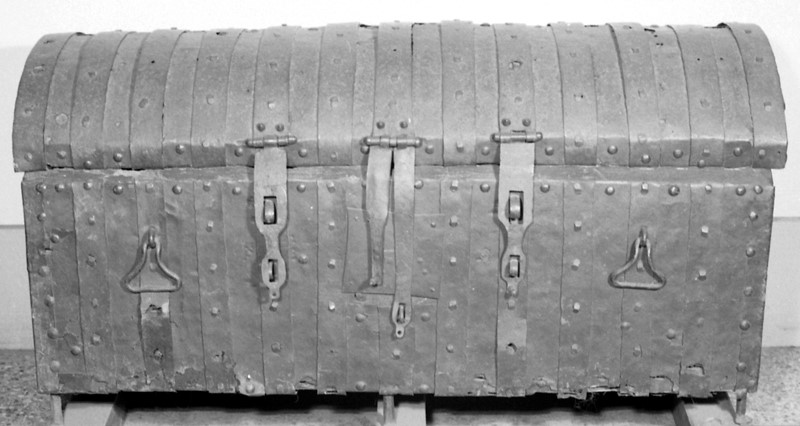
Figure 2: 14th century muniment chest, from the collections of The National Archives. Catalogue Reference: E 27/7 (image from Wikipedia).
Organisation was of course key, but the storage space needed to be secure as well. Storing the hundreds, perhaps thousands, of documents that were created by and for the Staffords meant that the space accommodating them needed to be substantial, controllable, and close at hand. This space is an essential part of the materiality of this corpus of these objects. Thornbury Castle in Gloucestershire was one of Buckingham’s primary residences. The south-western tower of the inner courtyard married the range accommodating the elite apartments of the duke and duchess to the range containing the steward’s apartments and the gatehouse. On the second and third floors of this tower was the muniments storage chambers. The uppermost was described in a later survey as the place where ‘evidents’ were kept.[1]
The top chambers were considered the safest places to keep important records. The close proximity of the muniment chamber to the duke’s and duchess’s bedchambers spatially recognises the importance of their safe keeping as well as their private nature. Not everyone had access to the south-west tower at Thornbury: it was theoretically controlled through its proximity to the high-status apartments. Placing the muniments chamber so close to the elite apartments and the steward’s bedchamber kept the documents under tight security, but also it linked the documents to the people most likely to use them. The space was hidden away from prying eyes and on a practical level from the potential of a kitchen fire and an easy walk from the elite apartments to the muniments chamber.
Today we think of archives as cultural – and public – statements about the past; however, the muniments chamber at Thornbury was deeply personal and individualistic in nature. Indeed, the records within the chamber were oftentimes personal with the names of tenants, the amount of rent owed, and their geographical location; it was essentially their personal data. The chamber became a space that held a living memory of the duke’s tenant base. For Buckingham, the muniments chamber was spatial soul of his lordship. It was a physical manifestation of his power; written down and recorded for posterity. For his tenants, however, the muniments chamber represented their powerlessness and the one-sidedness of early modern lordship. The documents are written testimony to the exploitation of Buckingham’s lordship. His tenants had no control over their information and the storage of it. Although the muniments chamber at Thornbury might be thought of as a shrine to Buckingham’s lordly power, it contained documents that were not static. They held the names and rents of the duke’s tenants, payments to household staff, and the buying and selling of resources all of which were changing. Although muniments chambers are an often neglected part of our understanding of castle space, they held records related to the wider network of power and wealth that the castle is meant to symbolise.
[1] Richard Braithwait, Some Rules and Orders for the Government of the House of an Earl set down by Richard Braithwait (London, 1821), p. 18.
[2] Braithwait, Some Rules and Orders, p. 18.
[3] Braithwait, Some Rules and Orders, p. 18.
[4] See A. Pugin, Examples of Gothic Architecture, 5 vols (London, 1831-8), II, p. 32.
[This is part of a much longer article about the Buckingham archive as an object that will appear in the Welsh History Review volume 30 number 2 in December 2020.]
Back in 2015 the Castle Studies Trust co-funded the post excavation & publication of Steven Bassett’s excavations 1972-1981 of Pleshey Castle in Essex. In the November 2018 issue of Current Archaeology (334) Patrick Allen explains how the review of the excavation materials has transformed our understanding of the castle and provided new insights into its character and development.
Around 5 miles northwest of Chelmsford in Essex we find a classic example of a motte and bailey fortification. Pleshey Castle offers invaluable insights into constructions of this kind, as while all of its buildings have long been demolished (apart from the late 15th-century brick bridge over the motte moat), its medieval earthworks have survived intact thanks to their never having been rebuilt in stone.
Its motte is original, dating from c.1100, while the ramparts of the south bailey are largely the result of refortification which took place in 1167. A second bailey to the north of the motte is now buried beneath the modern village, but its original outline can still be seen in Pleshey’s semi-circular street plan and in 1988 was confirmed by excavation. Its defences were levelled in the 13th century and replaced by a much larger town enclosure, whose earthworks still surround the modern village.
Planof the castle shows the keep and buildings in the south bailey with excavation areas in red
Previous descriptions of the castle had assumed that the north bailey was part of the original castle and the south bailey added later – but recent reassessment of all available evidence has transformed this picture completely.
Evolving the castle
What can we unpick about the castle’s origins? Its earliest documentary reference comes from 1143, when Geoffrey II de Mandeville surrendered all his lands, including Pleshey Castle, to King Stephen. Yet scientific research suggests the site is much older. Analysis of topsoil buried beneath the motte, and a calculation of the rate of its formation, suggests that the castle was completed 30-40 years after the Norman Conquest.
As for when construction began, tree-ring dating of a timber from the north bailey palisade provides a date no earlier than 1083, and a construction date of c.1100 seems entirely plausible. This would link the castle’s creation not to Geoffrey II de Mandeville, but to Geoffrey I – a logical conclusion as the core of his extensive estates lay in mid-Essex and Pleshey is close to his chief manor of Waltham (now Great Waltham).
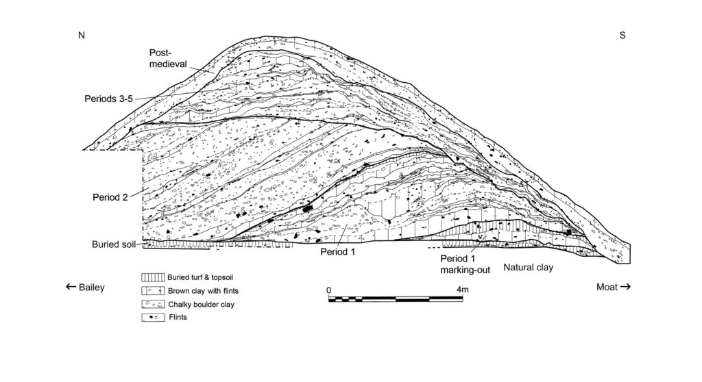
A section through the south bailey rampart shows how its earliest incarnation, as constructed c.1100 (Period 1), still survives at its base. Period 2 reflects the boundary’s englargement and refortification after 1167.
It is also becoming increasingly clear how the fortifications developed; Chelmsford Museums Service has been revisiting unpublished reports from an excavation that Steven Bassett undertook immediately to the south-east of the brick bridge in 1972-1981. Interestingly, a section that he recorded through the outer rampart confirms that the south bailey was also part of the original construction of the castle – that is, Pleshey boasted two baileys from its inception. Within this rampart (which was dated to the later 12th century by previous excavations headed by Philip Rahtz in 1959-1963), Bassett also found traces of a smaller, earlier rampart which had been built up in two stages, suggesting an initial temporary earthwork which was completed after a short interval.
As for later developments, historical accounts record that in 1157-1158 Henry II returned the de Mandeville lands to Geoffrey III on the condition that he dismantled the defences of his castles – but in 1167, Geoffrey’s younger brother William II de Mandeville was given permission to refortify. There is good archaeological evidence for a large-scale restoration of the castle defences after this date, following the same plan as before. Bassett’s excavation uncovered clear signs of a comprehensive clearing out of the moat during this period, and sections recorded by both Bassett and Rahtz (in an early dig) show the south bailey rampart being massively enlarged at the same time.
This, though, was the last major improvement to the castle defences. Its earth and timber fortifications provided sufficient protection against local insurrection, but the castle was not defensible against a major attack, and during the civil war that followed King John’s rejection of Magna Carta it changed hands twice. On Christmas Eve 1215 Pleshey Castle was seized by a detachment of the king’s army, and in the winter of 1216-1217 it was recaptured by the rebel barons – both times it was surrendered without a siege. The castle was militarily outdated, and after it was inherited by the powerful de Bohun family in 1227/1228 it became increasingly important not as a fortification but as their main residence and the administrative centre of a great aristocratic estate.
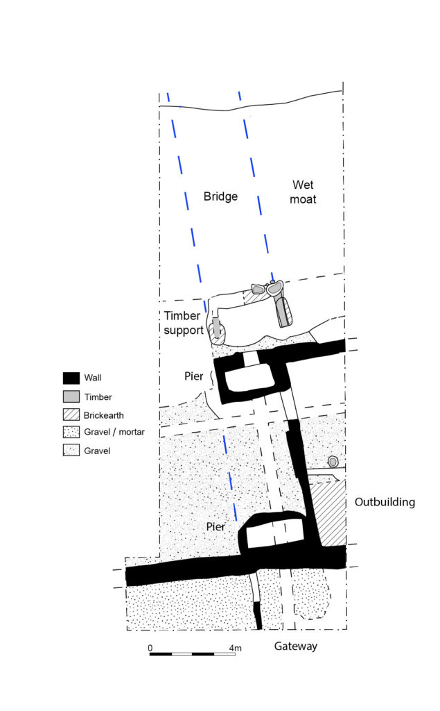
Between Pleshey’s refortification in 1167 and the late 14th/early 15th century four successive wooden bridges spanned the motte moat. Traces of these trestle structures were recorded by Bassett as well as in a small trench excavated by Elizabeth and John Sellers. The final development of the south end of the bridge consisted of two stone pier bases which would have supported box-frame timber uprights and, in front of these, a wooden structure supporting massive raked timbers which carried the central span of the bridge over the wet part of the moat.
At the south end of the timber bridge (its late C14 foundations are shown on this plan) was a gatehouse whose uppper space has been identified as the Queen’s chamber described in the building accounts
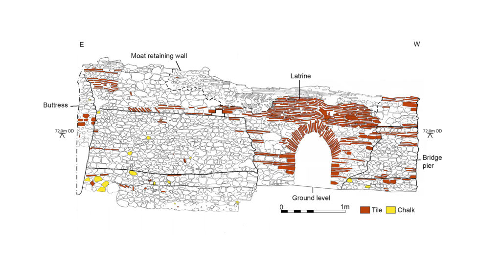
These strong foundations were needed at the bailey end of the bridge to support the greater load there from the bridge’s superstructure, whose walkway would have sloped steeply from the motte down to the bailey. Meanwhile, the elevation of the outer face of the northern bridge pier shows its solid construction and its continuation to the east to form a retaining wall for the moat. This pier was later reworked to create a latrine in the late 15th century – when the wooden bridge was replaced by a brick one – evidence of this change still survives in the form of an inserted arch and changes to the upper stonework.
This elevation shows the northernmost pier base of the late C14 bridge and the retaining wall to its east (the lower stonework) that shored up the moat. It was rebuilt in the late C15 as a latrine with an arched outlet.
What of other structures? As mentioned before, all of the castle’s buildings have long been demolished, but it is possible to piece together some clues. A plan of the buildings that were present in the south bailey from the 14th century onwards can be reconstructed using evidence from Bassett’s excavations and a 1960s parchmark survey by Elizabeth and John Sellers. Furthermore, the function of some specific buildings can be identified thanks to Pat Ryan’s study of the surviving mid-15th-century Duchy of Lancaster building accounts for the castle.
We are able to locate the chapel at the west end of the bailey, which was excavated by Rahtz in 1959-1963. To the east, the hall is easily identifiable, with its adjoining kitchen, pantry, and buttery. On its north side, storehouses were ranged around a kitchen yard which was accessible from the main gate immediately to the east. To the west of the hall was a range of large private chambers at first-floor level, above a wardrobe and other storerooms. These were a ‘revealing chamber’ (audience chamber), and at the west end of the range lay the ‘King’s chamber’ and, beyond it, the ‘Queen’s chamber’. This relates to the period 1421-1483 when Pleshey became part of the Duchy of Lancaster, the private estate of the Lancastrian kings, and was granted to three successive Queens of England: Catherine of Valois, Margaret of Anjou, and Elizabeth Woodville, the wives of Henry V, Henry VI, and Edward IV respectively.
Bassett’s excavations also recorded part of a stone-built gatehouse at the south end of the bridge, whose upper chamber can be identified as the Queen’s chamber in the building accounts. The gateway and the room to its west, possibly a guard chamber, were surfaced in gravel and mortar, but material found in the demolition rubble indicates that the Queen’s chamber above was much grander, with a floor of Penn-type decorated tiles, painted plastered walls, and leaded glazed windows.
Bassett’s investigations date the completion of the building range along the north side of the bailey to the late 14th century. These buildings would have been constructed by the de Bohuns and completed by Thomas of Woodstock, Duke of Gloucester (the youngest son of Edward III), who married Eleanor, the elder de Bohun heiress. It is she, as Duchess of Gloucester, who would have originally occupied the Queen’s chamber in its initial guise.
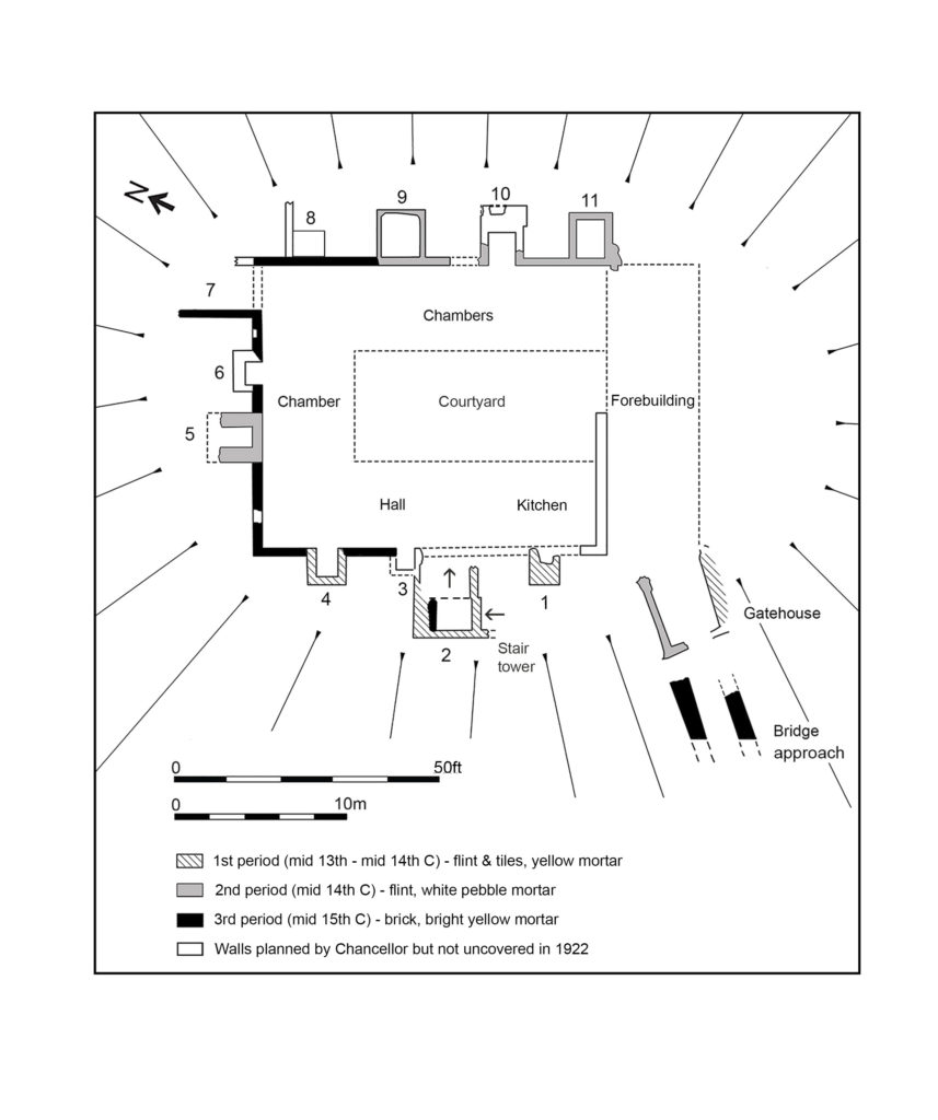
Exploring the keep
Our project also reassessed the results of the excavations focusing on the castle keep in 1907 and 1921-1922. There, the original excavators were puzzled by the ‘extreme thinness of the walls’, but we suggest that they should be interpreted as facades built around a timber-framed courtyard structure. The keep’s great hall has been located using its description in the building accounts, while the other ranges are thought to represent chambers with ‘ensuite’ accommodation, each with a fireplace and a privy (which survive as rectangular projections that are open to the interior, and enclosed, respectively).
A reconstructed plan of the keep, with added stair tower, fireplaces/chimneys and latrines
The final renovation of the keep – carried out on the orders of Margaret of Anjou and described in detail in the building accounts for 1458-1459, where the keep is referred to as a ‘tower’ – was finished in brick. The accounts also record that 29 oaks were felled for the work and that most of the money was spent on employing carpenters – confirmation that the keep was mainly built in timber, as suggested above. Two earlier periods of flint facades and additional structures are dated to the mid-13th/mid-14th century and the late 14th century respectively (by comparison of mortar types with well-dated structures recorded in Bassett’s excavations). No doubt the stone and brick facades made an essentially timber structure look more impressive.
The renovation of the keep was completed by building the brick bridge over the moat, probably in 1477-1480, according to Pat Ryan’s study of the building accounts. This was 20 years after the work on the keep itself – perhaps the works were delayed by the Wars of the Roses (1455-1487). The brick bridge is one of the earliest of its type in Europe and, with its wide span, was a very advanced design for its time. By the mid-16th century, though, the castle had become derelict, with the motte mound used as a rabbit warren, and it was sold by Elizabeth I in 1559. Ironically, the brick bridge was preserved only because the Duchy of Lancaster surveyors recommended that it be retained to maintain access to the warren. Today, it still stands as one of the few elements of the castle surviving above ground. Analysis of excavated evidence has enabled us to add much more colour to this picture, and to reconstruct Pleshey Castle’s appearance once more.
The author would like to thank the following for grants towards the project: the Castle Studies Trust, the Marc Fitch Fund, the Essex Heritage Trust, and the Essex Society for Archaeology and History.
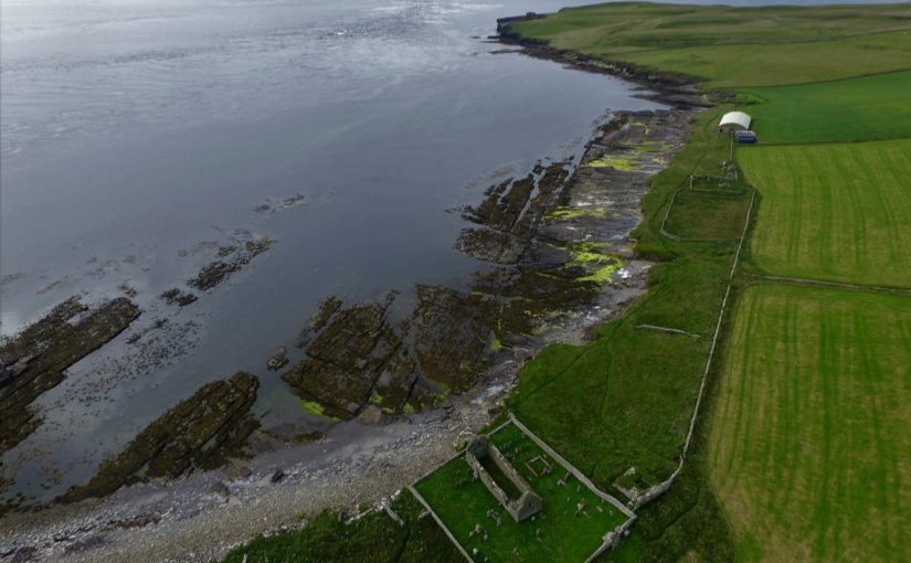
Featured image: Aerial view of Pleshey courtesy of Chelmsford Museums Service
With HES giving the provisional sign off for the excavation at The Wirk to take place in the week commencing 21 September, and the geophys survey to take place the previous week, project leads Drs Dan Lee and Sarah Jane Gibbon outline the background to the project and what they hope to find.
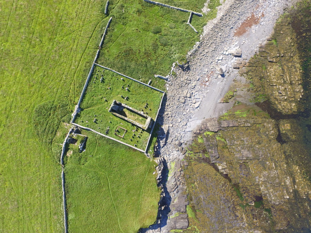
Located on the south-western coast of Rousay, The Wirk is located in one of the most archaeologically rich parts of Orkney. The Orkney Research Centre for Archaeology (ORCA) is undertaking geophysical survey, archaeological excavations and 3D modelling at this enigmatic castle site (pending approval from HES).
The Wirk, meaning stronghold in Old Norse, and with the alternative name Westness Castle, is a small stone tower located close to the coast. It has variously been interpreted as a 12th century Norse Castle, a detached fortified bell-tower, a 13th century defensive tower for an incomplete church, a hall-house garderobe tower and most recently a 16th century tower and attached range.
The Wirk located on the side of St Mary’s Church graveyard, looking south. credit: Bobby Friel @TakeTheHighView
Minor clearance and excavation in the 1920s identified similarities in construction between The Wirk and the 12th century Cubbie Roo’s Castle, on the nearby island of Wyre, considered to be one of the earliest stone keeps in Scotland. The Wirk is located in Westness which has been a large estate since at least the 12th century when it was the home of the Norse chieftain Sigurd of Westness (Orkneyinga saga). It is adjacent to Rousay parish church, likely to date from the 12th century, with standing remains of 16th century date on earlier footings.
Recently, the 12th/13th century date attribution of The Wirk has been rejected in favour of a 16th century date. This new interpretation is based on the built remains and 16th century architectural fragments which were found in the 1920s. However, architectural fragments of 12th/13th century date were also present and nearby archaeology, particularly the discovery earlier this year of a Norse hall at Skaill by the UHI Archaeology Institute would suggest this was a high-status place in the saga period. This is not to dispute that The Wirk may also have been in use in the 16th century when the estate was owned by a prominent Orkney family. One of the objectives of this project is to excavate trial trenches over Clouston’s excavation and at the eastern end of the site to identify the earliest phases of the tower and adjacent building. Upper parts of the tower were substantially rebuilt in the 19th century and so excavation will allow us to record parts of the site that have not been knowingly rebuilt.
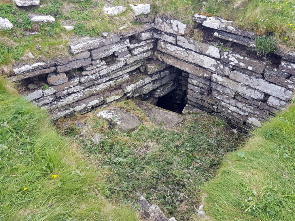
Inside The Wirk tower, looking southeast, showing the entrance to an underground well or passage (Image: Dan Lee)
Along with the excavations, targeted geophysical survey around The Wirk aims to better understand any relationships between the tower and the buildings/features which surround it. 3D modelling of The Wirk and Cubbie Roo’s Castle will enhance our understanding of these comparable sites and allow the public to explore the remains online.
Clouston, JS 1931 Early Norse Castles. The Orcadian. Kirkwall
Gibbon SJ 2017 A Survey of Norse Castles in Orkney, in P Martin (ed) Castles and Galleys: A reassessment of the historic galley-castles of the Norse-Gaelic seaways. Islands Book Trust. Laxay. 226-248.
Featured image: View of The Wirk, located on the righthand corner of St Mary’s Church yard in the foreground, looking northwest to Midhowe and the Atlantic Ocean (Image: Bobby Friel @TakeTheHighView).


