Doon on the lochfront: Loch Doon Castle (Ayrshire, Scotland)

As part of his 2018 PhD thesis on Scotland’s early stone castles, Dr Will Wyeth assessed some of the country’s underexplored sites. One such was Loch Doon castle which provides a case study for two of Will’s key themes of his research, namely the castle’s orientation and its landscape.

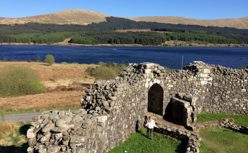
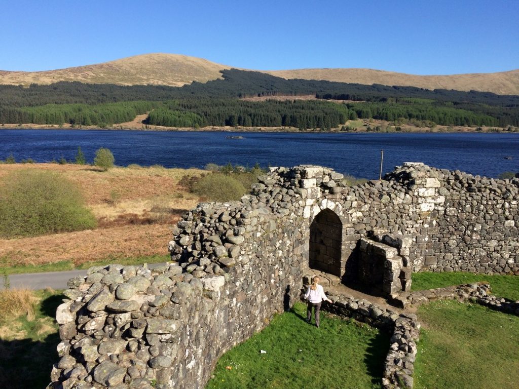
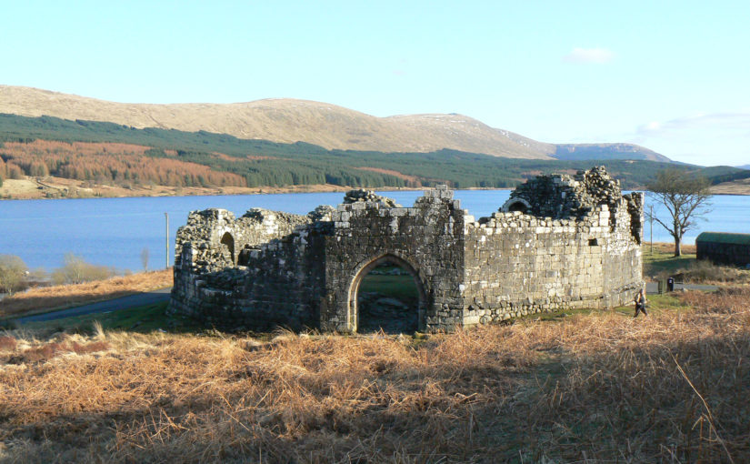
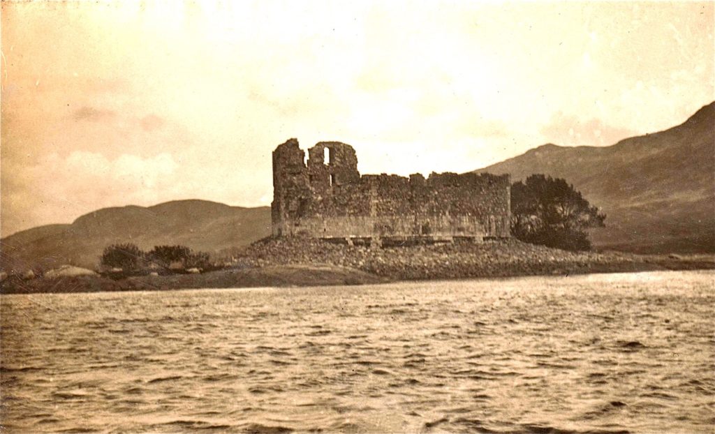
Loch Doon was home to a series of small islands, one of which was largely occupied by a medieval castle, comprising an enclosure and within it, parts of a later medieval tower house. In 1935 the loch was dammed and in consequence of the resulting rising water level, the castle dismantled and re-assembled on the modern lochside to the west of its original position.

Original location of Loch Doon Castle, picture taken between 1902-18. Picture courtesy of Brian McGarrigle, Scottish Castle Association

Connecting its architecture with the emergence of scattered references in documentary sources, we believe it was built by the mid-late 13th-century earls of Carrick, among whose members were Robert de Brus and his son by the same name, later Robert I. The castle appears in the 1370s Scottish (as opposed to the revised early 15th-century English) portion of the ‘Gough Map’ as loghdone. Little store can really be set by its depiction there, owing to uncertain cartographic conventions, though it is noteworthy that it is represented by two castle icons – one on the loch island, another on the adjacent shore.

Loch Doon castle featured in an episode of the war which saw Sir Christopher Seton, brother-in-law of Robert the Bruce flee to the castle. It was besieged and thereafter was surrendered to English troops by Sir Gilbert de Carrick in 1306, who was probably a kinsman to Robert. While the meagre early history of the castle is reasonably well-known, what has hitherto not been explored in great detail are two other elements of Loch Doon Castle. What can it tell us about its builders? And is there evidence for a wider landscape to the castle, and what can this tell us?

Why build it on an island?

There is a significant volume of evidence, and discussion by many earlier and contemporary historians, regarding the long-lived tradition of natural, modified or artificial island lordship centres in Scotland. So was Loch Doon castle referencing this tradition, alive and well in contemporary Scotland? I argued that while there was no question of an island site’s defensive advantages, as well as an acknowledged similarity to the crannog tradition, Loch Doon castle was more of a castle than a crannog-like castle.

Loch Doon Castle Main Entrance, copyright Prof. Richard Oram

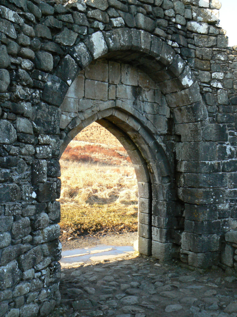
The way the castle’s formal entry point, its large pointed portal, opened nearly straight onto water, whilst its work-a-day entry (the sole other access) opened onto part of the island with a beach for ease of landing and more space, suggested similarities with the managed routes of access to castles specifically: the rest of the island can be imagined as small outer yard. Such routes and configurations may have been apparent in contemporary crannogs, but evidence is simply lacking. Both insular castles and medieval crannogs may have been built to draw attention to vast sheets of natural water for which terrestrial castles elsewhere used ponds and lakes. The castle’s long southern wall, forming the exterior face of its great hall, was designed for maximum exposure to the sun, but also towards routes from Galloway in the south.

A landscape context?

The castle is situated at the border of two counties; indeed, at the time of its construction, it was located at the south-eastern extremity of the earldom of Carrick. A routeway from the political heartland of medieval Galloway in Glenken runs through the valley of Loch Doon towards the royal centre at Ayr. Another route ran from another politically important area in eastern Wigtownshire into the valley of Loch Doon.

There is evidence for all kinds of medieval activity near to the castle. At the farm sites of Starr and Loch Head south of the castle are traces of rig-and-furrow cultivation assumed to be medieval in origin. The nearby farm of Portmark evidenced later medieval metalworking, and its name suggests a tangible connection to the castle; elsewhere, port– place-names mark the embarkation point for medieval crossing to insular lordship centres. Perhaps this was what the Gough map was representing as a second ‘castle’? Such composite island-waterside complexes are widely recognised in Ireland. Lastly, in the rugged hilly district south of the castle, in neighbouring Galloway, are a cluster of place-names connected to deer traps, from the Gaelic eileirig, as well as the location of a hitherto unattested hunt hall (possibly medieval in origin) at the aptly named ruined building named Hunt Ha’.

What was the castle ‘for’?

It is difficult to establish a conclusive answer. In 1306, Sir Henry Percy seized administrative and military documents stored at the castle for the English crown following its surrender. Whether these documents were at the castle as a matter of course (so making the castle a manorial centre of sorts) or because of the political violence unfolding across the kingdom is not clear. Both may be true. The evidence from the castle and its landscape suggests it was ‘doing’ many things. It was made to be seen from far and wide. Its position by a routeway through the rugged Galloway Hills is typical for castles in general. Its insular setting may reflect a castellar rendering of the crannog tradition, or a Carrick take on the watery landscapes of castles lowland Britain and Ireland. The earldom’s main and older centre – Turnberry castle, on the coast in lowland Carrick and over 31km as the crow flies from Loch Doon – was its only other castle. Thus, Loch Doon castle may have as much been a retreat for leisure, for welcoming guests and the comital ensemble travelling to Galloway, as an administrative centre for the earldom’s extensive upland districts.

You can read Will’s PhD thesis for free on the University of Stirling’s website.

Conclusions from an almost-thesis

Research on castles has outgrown the walls of architecture, sprung from the rubbly tangle of archaeology and taken flight from the pages of law texts, charters and literary exposition. In the hands of an adept writer, these are small bumps on the road to timely completion. Presently, however, I find myself in the camp of the almost-complete thesis writers (PhD fourth-yearers: here is fellowship!). It is a credit to castle studies that there is so much to think and write about and, perhaps, get lost in. This post shares some of the most interesting conclusions from my work looking at early stone castles in two polities in medieval Scotland, the Earldom of Orkney and the Lordship of Galloway. Among the themes I examined was the transition from timber to stone architecture, the relationship of castle to landscape and the political context for castle construction in these areas.

Why Orkney and Galloway? To begin with, we cannot be certain why castles appeared in non-‘feudal’ Orkney in the first place. Secondly, one of Orkney’s early castle sites, according to accepted wisdom, is the prototype for a larger group of early castle sites in the earldom – and has influenced larger debates on castles in Scotland more generally. Cubbie Roo’s Castle, this foremost plank of Orcadian castellar wisdom is, I believe, a little younger than widely believed. Nevertheless, the evidence suggests Orkney was probably home to a stone castle founded around the middle of the 12th century, decidedly early for this part of the world.

Figure 1. View of site of Cubbie Roo’s Castle, Wyre, Orkney, in the distance atop the highest hill on the small island. The farm on the right may represent the 12th-century home farm. The ruined building on the left in the distance is the chapel site. ©William Wyeth.

If the castle site (but not the surviving architecture) is genuine, then the attendant landscape must be examined too, for Cubbie Roo’s and other Orcadian castles. Following a conventional model of castle as the centre of lordship, one would expect to find churches and important farm sites close to suspected or documented castle sites. This was simply not the case in Orkney. Cubbie Roo’s and the other castle sites I examined were, on present (chiefly place-name) evidence, sited on marginal lands of indifferent quality. Some preserved evidence of associated chapel sites, which fits with the conventional model of early castellar lordship.

The disconnect between terrestrial wealth and castle location opened three possibilities about the origin and siting of castles: firstly, were these defensive sites? If defence included a consistent grasp of the surrounding area, including major seaways through the Earldom, then the answer is no. Secondly, were these sites connected to maritime wealth? It is entirely plausible: recent research has demonstrated the wealth of the earldom derived massive fisheries exploitation. Thirdly, were these sites connected to ‘new’ arrivals to the Earldom? The political upheavals in the Kingdom of Norway (to which Orkney belonged) saw magnates appear in the Earldom with no obvious familial connection. The lack of obvious relationship with good farming land may be taken to suggest the castles were built on land acquired more for the purposes of castle building (and architectural showmanship) and maritime exploitation than the inherent wealth of the soil. The new men’s power derived from proximity to the Earl, not a direct ancestral claim to a portion of Orkney’s economic output. Orkney’s earliest castles, whatever their form, were the product and reflection of a shift in how comital wealth and power operated.

Figure 2. View from the top of Cubbie Roo’s Castle, overlooking the possible home farm. The island in the distance on the right (Egilsay) is home to the Church of St Magnus (visible by its distinctive round tower mid-way along the island’s profile); the cult of St Magnus was instrumental in the formation of distinctly Orcadian political identity in the medieval period. ©William Wyeth.

Galloway’s castles present a different challenge; though as a group they are more numerous than their Orcadian counterparts, the evidence for them is drastically more erratic. The exquisite (and displaced) Loch Doon Castle is more clearly understood than the hummocky mound of Castledykes outside Kirkcudbright, for example. On a cursory examination of both sites’ landscapes shows that Castledykes is much easier to understand. Kirkcudbright was the centre of the powerful Lordship of Galloway.  Its hinterlands feature no fewer than three monastic foundations by the Lords, and the probable extent of demesne estate concentration in the area around Kirkcudbright is one of the highest in the Lordship.

What of Loch Doon Castle? Any modern visitor will appreciate the eponymous loch is remote and difficult to access from the big towns of Scotland’s south-west. However, it was originally built on an island in the Loch and later dismantled and reconstructed on the shore. It initially sat on a substantial route-way between the Glenken in Galloway – another demesne area of the Lords – and the Scottish coastal royal burgh and castle of Ayr. Another route south of Loch Doon offered access to the southern area of Carrick and, via the River Cree, the Wigtownshire portion of the Lordship of Galloway, with its probable administrative centre at Cruggleton Castle. Though its landscape is presently dominated by fishing holiday cottages and forestry, place-name evidence suggests in the medieval period the area was exploited for its pastoral suitability, and analogous documentary evidence from monastic sources hint at mineral wealth too. Doubtless Loch Doon Castle also formed an upland centre in Carrick in counterpart to the lowland, maritime-oriented centre at Turnberry Castle (also surveyed during this project).

Figure 3. Loch Doon Castle, view from wall-top towards loch. The castle was moved stone-by-stone before the construction of damming schemes in the mid-20th century. It was originally located on the partially submerged island in the loch visible here. ©William Wyeth.

Lastly, an overview for all of Scotland. A small, prefacing section of my thesis examined the monuments record for all possible castle sites in Scotland, including the sites above and less conventional secular power centres in the 12th-14th centuries – palaces, enclosures, crannogs (artificial islands in lochs), duns and brochs. A growing body of evidence in Scotland suggests many sites typically understood as prehistoric (chiefly the last three aforementioned categories of sites) were re-occupied during the broad medieval period. One conclusion from this country-level study suggested that there were more medieval power centres (e.g. bearing evidence for occupation) per square kilometre in the western counties of Scotland than the east. This likely reflects the underlying patterns of early medieval lordship in Scotland over which the culture of castles was overlain. This may act as another, belated, nail in the coffin of the military-architecture thesis of castle studies in Scotland.

The framework of understanding castles through landscape as much as architecture and archaeology is one I hope to apply more widely to Scotland and, as I engage more fully with English castle studies in my new job, in the wider medieval world.