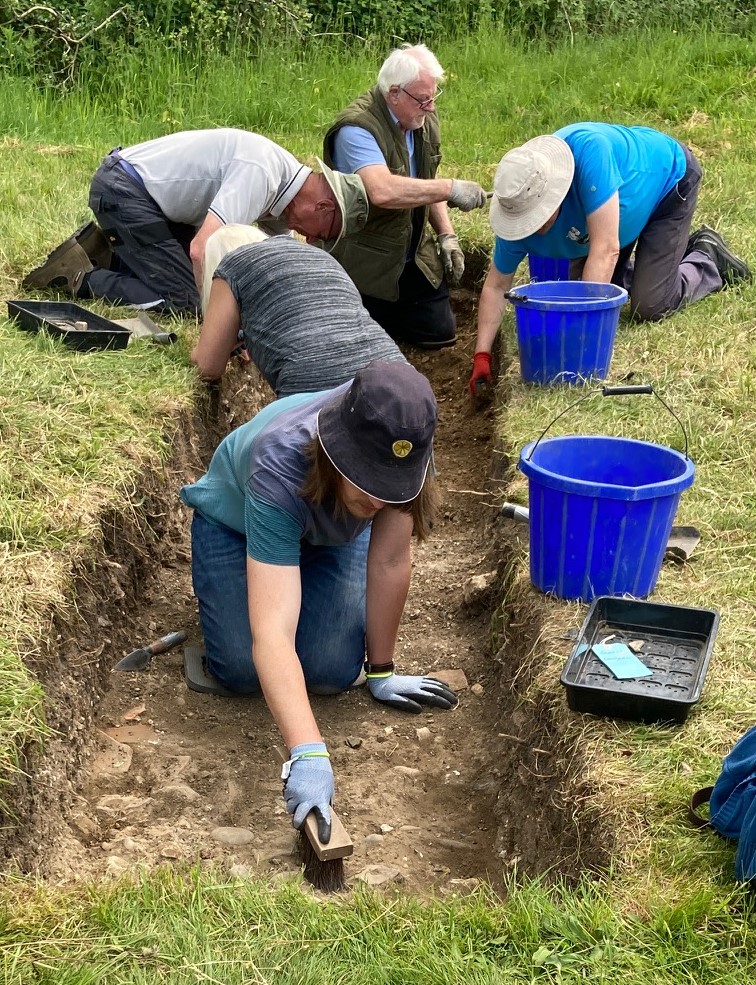
Excavation director Simon Coxall gives an update of what happened on Friday 6 June.
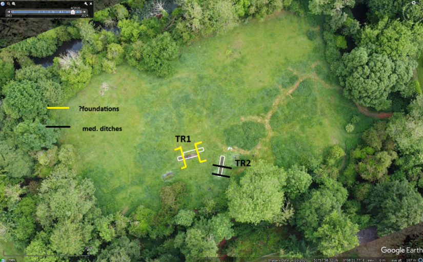
In Trench 1 the trackway limits were established and exploration of its junction with the structural foundations to the west has been a little problematic at first. The foundations appear to consist of a dense concretion of sand gravels and small sub-angular flint cobbles rather than the larger flint cobbles that were anticipated. Such larger cobbles as survive are redeposited remnants of the former walls perhaps not though worthy to recover from the demolition.
There is nearby corroboration of this foundation method from records of when Saffron Walden castle was explored.
‘…Archaeological excavation and monitoring was carried out prior to and during repair work to the retaining wall between the north side of Saffron Walden Castle and the rear of 30 Castle Street. A 1m-wide trench, stepped for safety, was excavated through the deposits to the south of the wall. Natural chalk was exposed in the base of the trench at a depth of c. 2m below the ground surface. This was sealed by buried medieval topsoil upon which were a series of compacted sand, flint and chalk deposits interpreted as the foundations of the mid-14th century inner bailey curtain wall. The foundations were found to extend along the length of the retaining wall during monitoring. ‘
The depth of these foundations has still to be established. Both the foundation and trackway are to be sampled for evidence of construction methods and perhaps phased construction.
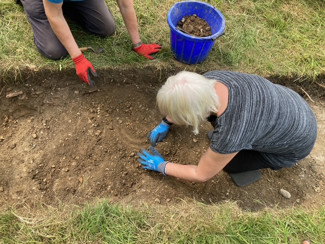
Discovery of the ditch on Wednesday at first thought to be a beam slot, courtesy of Jacky Cooper
In Trench 2 the beam slot found on Wednesday has morphed into a ditch with dark humic fill. At its uppermost levels this contained two sherds of medieval pottery Sandy ware probably for the same vessel estimated as being 14th century. This is being cleaned/defined prior to full excavation of its fill. The ditch encountered at the southern extent of Trench 2 has been excavated and found to contain in the main demolition materials in its upper levels with a medieval jug handle (?) present in the lower fills as presented in the trench’s eastern balk.
The trench has shown the propensity for features hitherto not recorded by geophysics and will be explored further.
A sketch with approximate trench locations is the featured image and courtesy of Simon. The trenches are being georeferenced in with Oxford Archaeology East assistance on Monday. There’s a decision to be made today (Saturday) regarding extension of either trench to achieve the current excavation limit of 2 x c.2m trenches.
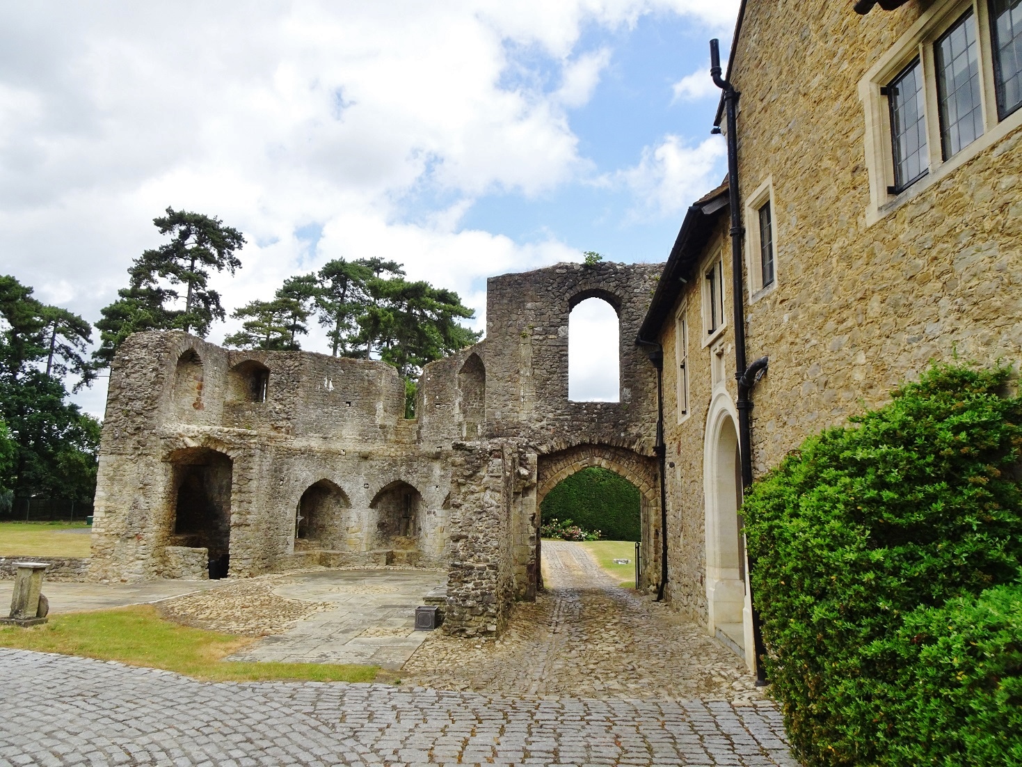
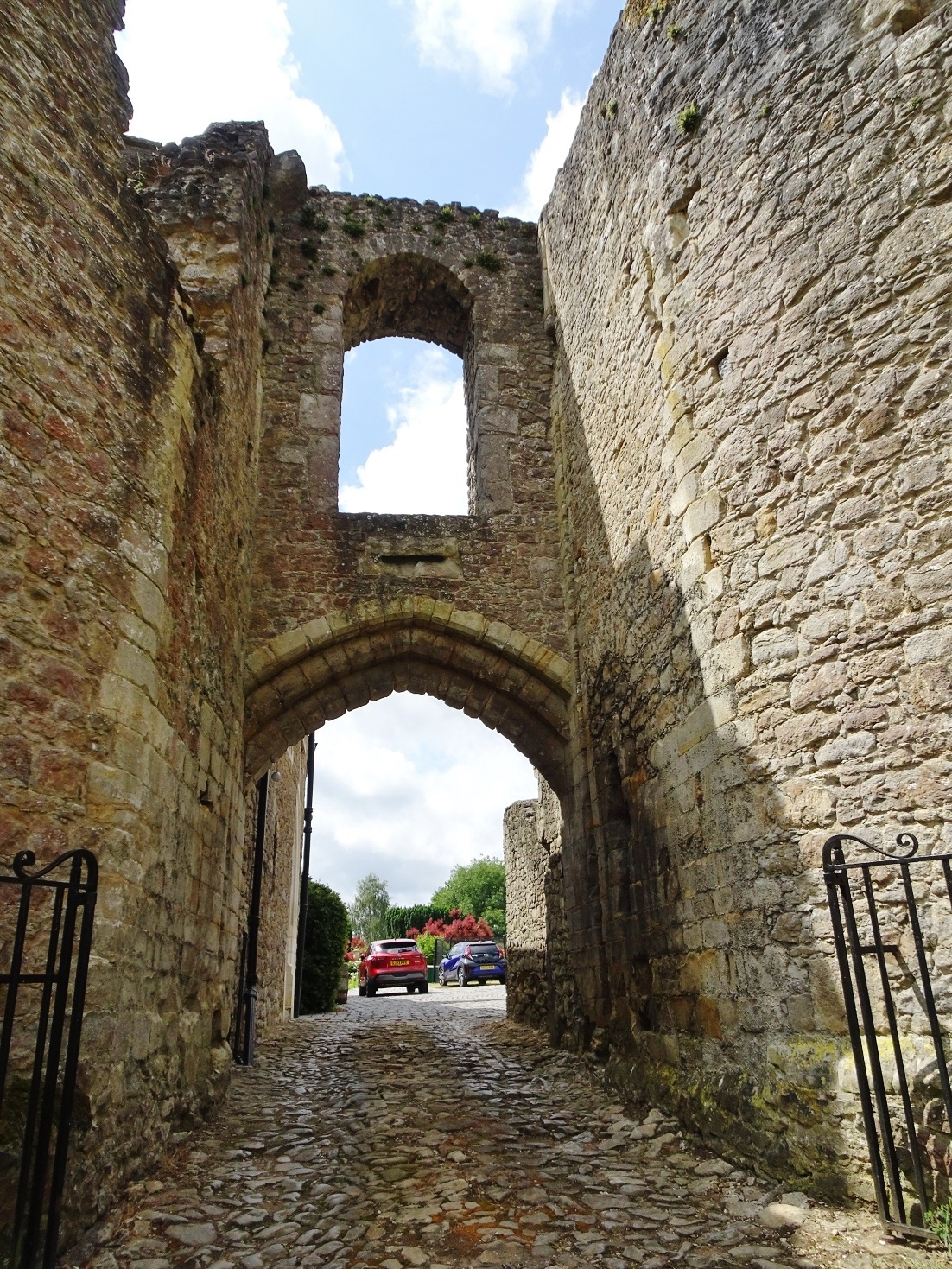
On Monday 2 June volunteer excavators led by Simon Coxall, along with his Warboys Archaeology Group (WAG) and Oxford Archaeology East got underway with the opening of two trenches at Clavering Castle focussed on the eastern side of the castle.
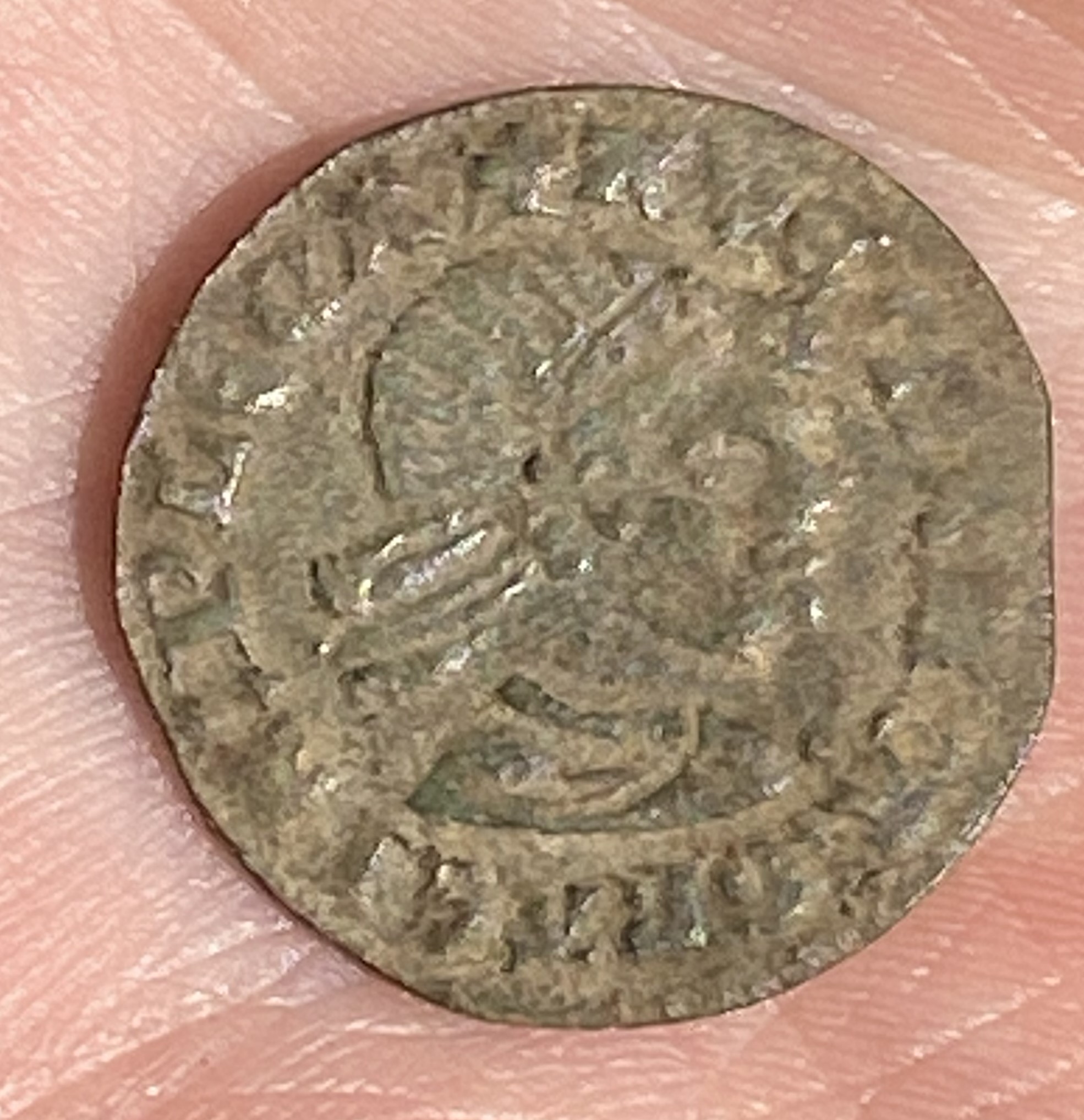
On the first couple of days the excavators predominantly demolition rubble such as roof tiles, but other finds too some worked flint and some medieval nails, a musket ball and most interestingly a fourteenth or fifteenth century French jetton. According to one of the WAG team, Andrew Noakes, the jetton is quite a rare item because it features a Moor’s head. The inscription in French translates as ‘For the queen and her almonry’.
French jetton with Moors head copyright Jacky Cooper
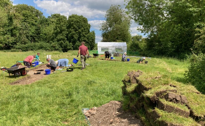
The Clav25 dig at Clavering Castle was sadly hit by rain on the third and fourth days but nevertheless there was good progress in both trenches. In Trench 1 a sandy grit surface was reached which proceeds 2m north to south across the centre of the trench. This is interpreted as the central trackway of the Castle’s entrance court. Some sherds of late medieval/ early modern pottery were recovered from the demolition layers immediately overlaying the trackway. The trackway appears to extend across the area between the evidence for flint structures to the east and west. Meanwhile, at the southern limits of Trench 2, a ditch has been exposed which appears full of demolition material. Material coming out of the trenches includes a lot of roof tile and oyster shell, but very little pottery so far.
Hard at work in trench two on Wednesday, copyright Jacky Cooper
With the trenches starting to show promise more we will have an update at the end of the week, weather permitting. If it isn’t being kind then early next week.
Excavation Director, and lead archaeologist for the past two decades in the investigation of Clavering Castle sets the scene for what they hope to find over the the next three weeks.
Norman knights fleeing the forces of Earl Godwin of Wessex coupled with miraculous encounters between King Edward the Confessor and St John the Evangelist form just part of the shady historical drama hidden behind the leafy tranquillity of Clavering Castle in north-west Essex.
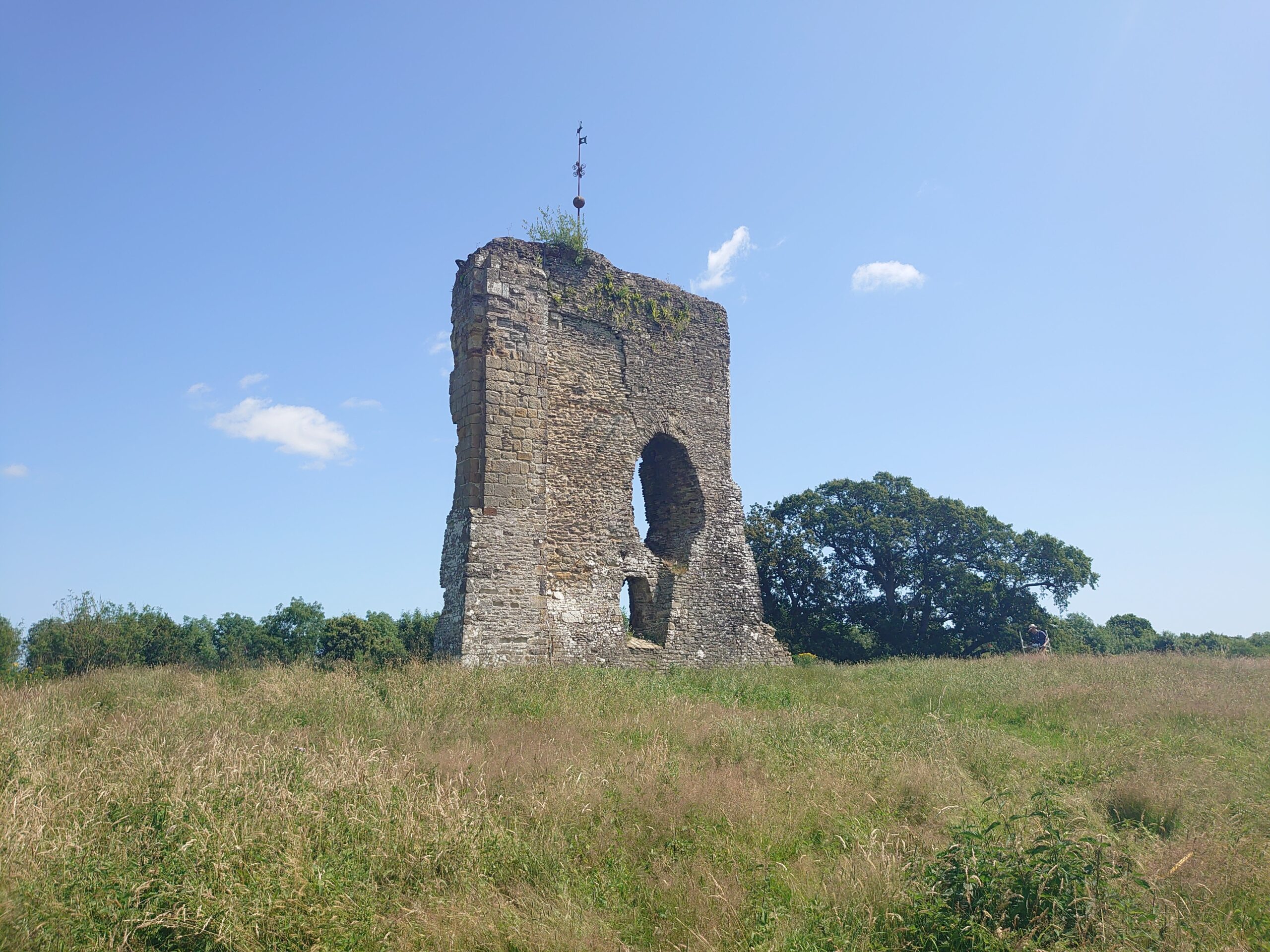
The scheduled site of Clavering castle is recognised as a rare example of a castle established in Anglo-Saxon England before the Norman Conquest. The castle has been subject of a twenty year programme of detailed historical and archaeological research by the Clavering Landscape History Group. This summer, archaeologists led by Simon Coxall of Warboys Archaeology Group, under a consent granted by Historic England and supported by the Castle Studies Trust, have a unique opportunity to explore by excavation this mysterious and previously unexcavated site.
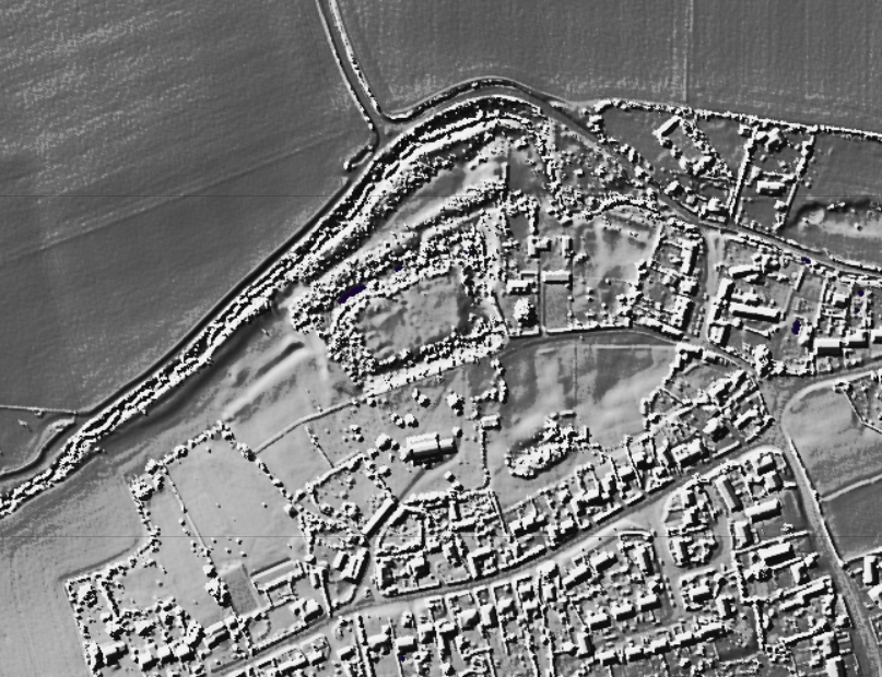
Clavering LiDAR base
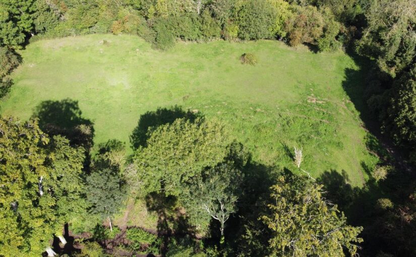
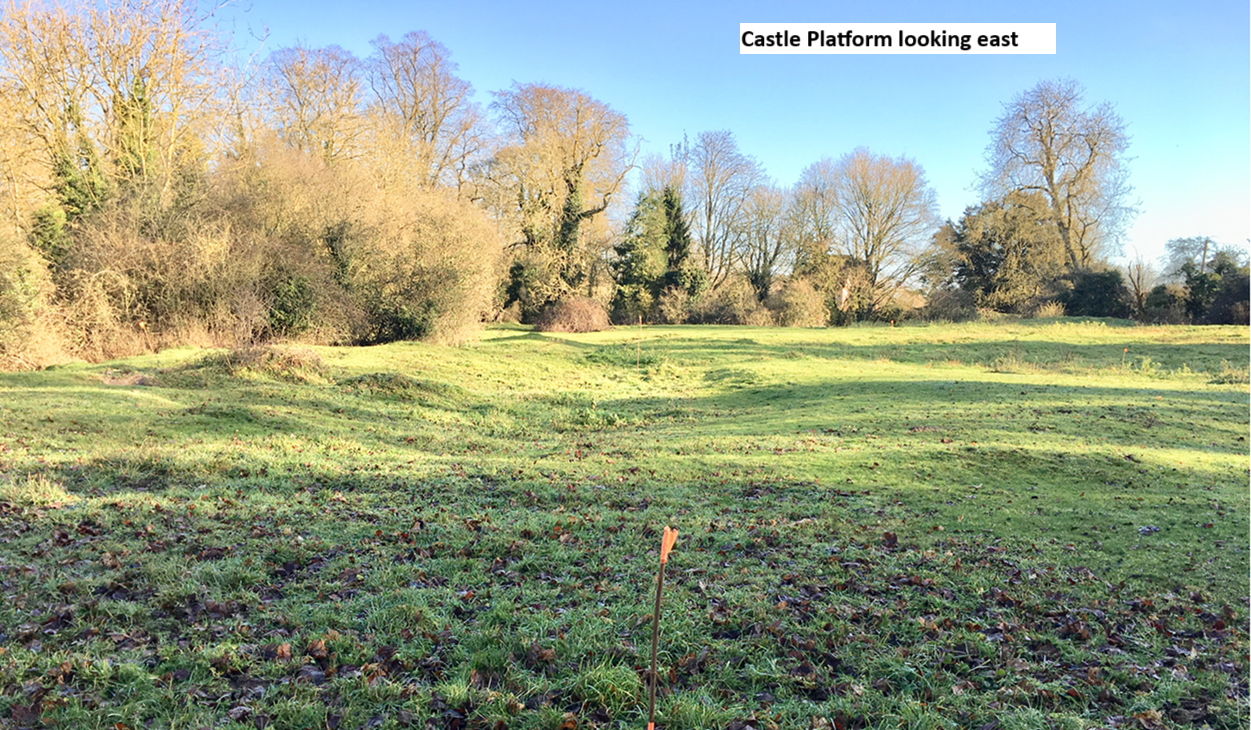
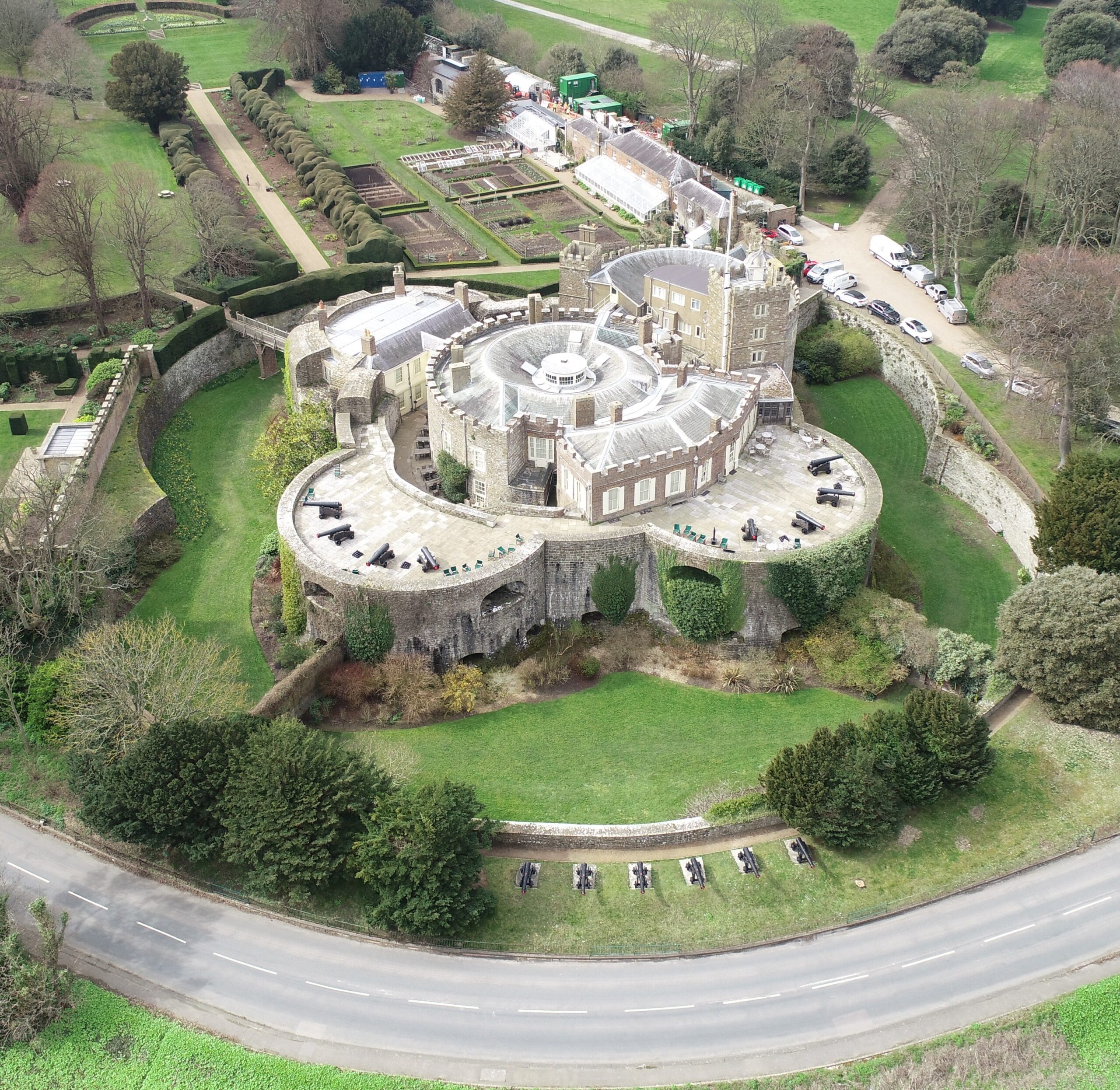
The castle platform which is entirely man-made is surrounded on all sides by imposing moated defences c4m deep and sits in the valley of the river Stort which evidence suggests witnessed significant diversion and management of its river system to accommodate the estate.
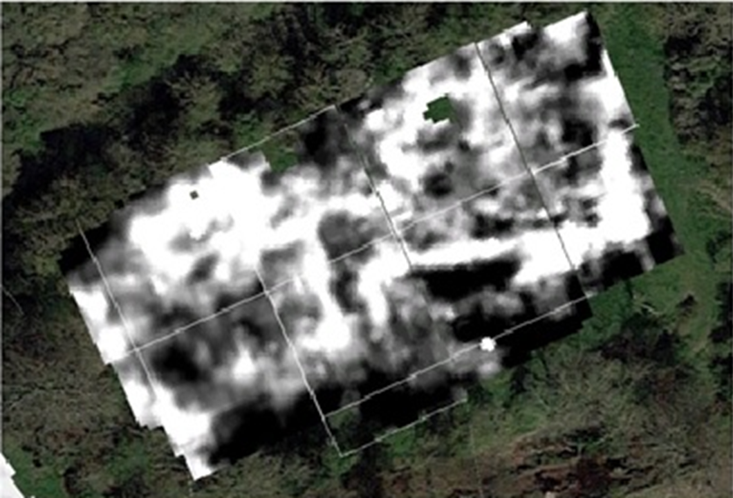
Resistivity Survey of Clavering Castle Platform, copyright Warboys Archaeology
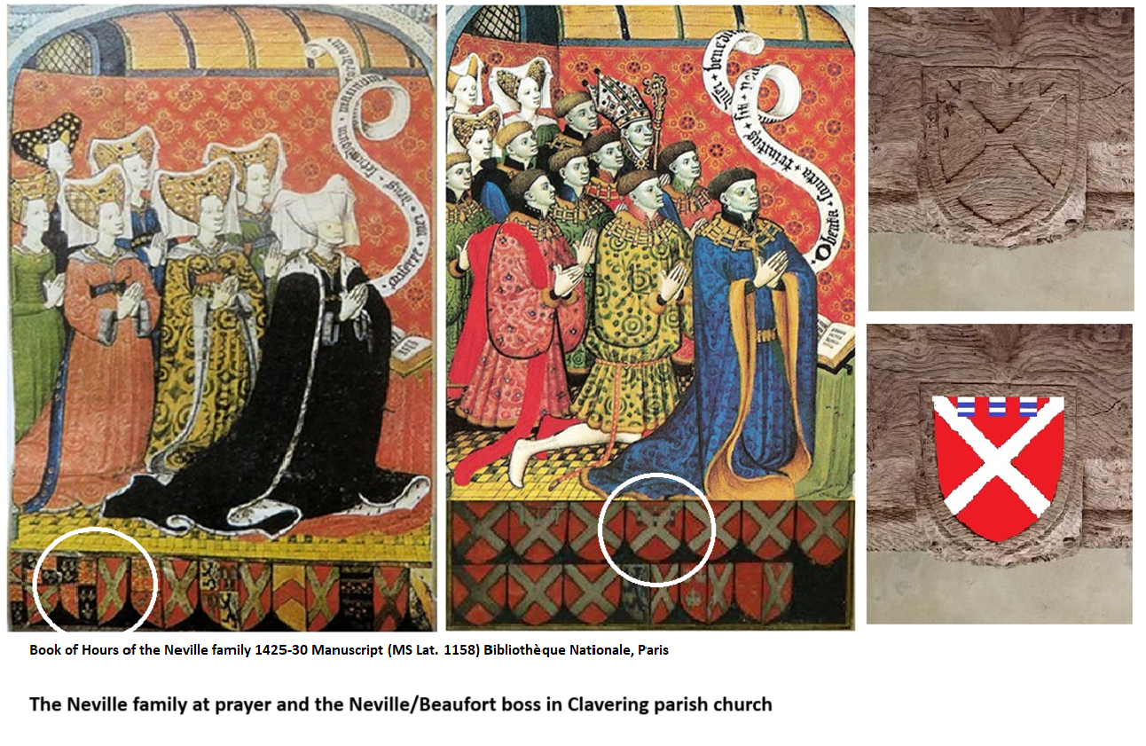
Geophysical survey suggests structures occupying twin courtyards once existed spanning across the sub-rectangular platform which measures c100m x 60m. The Castle platform abuts the parish churchyard to its south. Here further geophysical survey suggests the location of the now ‘lost’ chapel of St John the Evangelist which bore witness to Edward the Confessor’s aforementioned ‘Miracle of the Ring’. The twin courtyards appear connected to one another by an entrance court which issued out onto a bridged crossing of the moat connecting the castle with the family chapel where the alleged miracle occurred. It is suspected the geophysical evidence primarily relates to the powerful Neville family’s reconstruction of the castle site in the later 14th century, although some more ephemeral readings hint at the presence of earlier structures.
The Nevilles were arguably the most powerful baronial family in England during the 15th century and were through their marriage alliances with the Plantagenet royal family at the forefront of the dynastic conflicts now known as the Wars of the Roses. Clavering was selected by the Nevilles as their southern caput, these notorious northern lords presiding over their lordship and hundred of Clavering lying just a day’s ride from London. Clavering castle was successively held by the Neville Earls of Westmorland, Richard Earl of Salisbury, Richard Earl of Warwick and, through his Neville wife, George Duke of Clarence, the executed brother of the Yorkist kings Edward IV and Richard III. With the fall of the house of Neville the castle was seized by the Crown and stayed a crown possession until it was granted back to effectively the last Neville lord of Clavering – Margaret Pole, Countess of Salisbury (1473-1541) Though she refurbished elements of the castle and chapel in the 1520’s, as a devout Catholic and one of the last surviving scions of the Plantagenet royal family she too was executed on the orders of Henry VIII in 1541.
Beneath the levels denoting the Neville tenure of the lordship, archaeologists are hopeful of encountering earlier evidence of the de Clavering and FitzWymarc occupation of the castle. The de Claverings were, like the Nevilles, powerful lords of the north who feature extensively as Magna Carta sureties and later campaigning knights under Edward I and Edward II. With Robert FitzWymarc (c1030-1075) we return to the pre-conquest evidence that promises to push the history of the site back a thousand years to the dying days of Anglo-Saxon England.
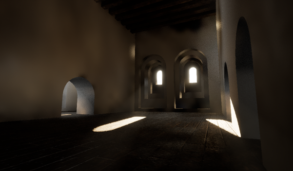
Clavering Castle Platform looking east, copyright Simon Coxall
This summer’s excavations will initially focus upon the key area around the entrance court connecting the castle platform with the adjacent churchyard. Such will seek to explore the entrance court and bridged crossing, the various phases involved in their construction, the materials used and its status, whilst testing the geophysical responses.
Digging deeper still, in the same key area archaeologists are hopeful of exploring the earliest evidence for the construction of the castle platform as revealed by the layers underlying the later medieval structures on site. In doing so fresh light will be shone upon the earliest days of castle construction in medieval England.
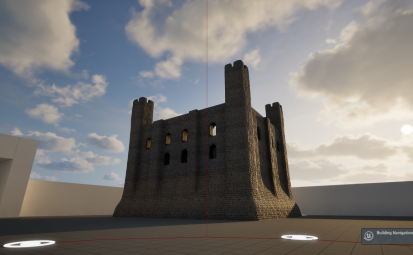
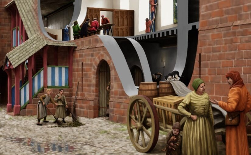
Canterbury Christ Church University was thrilled to receive funding from the Castle Studies Trust for a nine-month project that will produce a new digital reconstruction of Canterbury Castle’s Norman keep in the first century of its construction. The project’s ambition is to then use this new digital asset to create a pop-up exhibition and develop a curriculum resource for schools.
Screenshot of initial ‘whitebox’ of Canterbury Castle’s Norman keep and surrounding structures (courtesy of Mike Farrant)
Canterbury Castle is one of 104 national examples of a tower keep castles (Scheduled Monument Number 1005194 (link)), and one of 20 Norman Castles built in Kent. It is part of a series of royal castles on the route from Dover to London and identified as being one of the earlier examples of the period, usually dated to between 1085-1125, with archaeological evidence suggesting a date c.1100-1125. It has been comparatively overlooked in the research of royal castles of the area, and the role that the castle has played in shaping the city has been overshadowed by other historic monuments, namely Canterbury Cathedral.
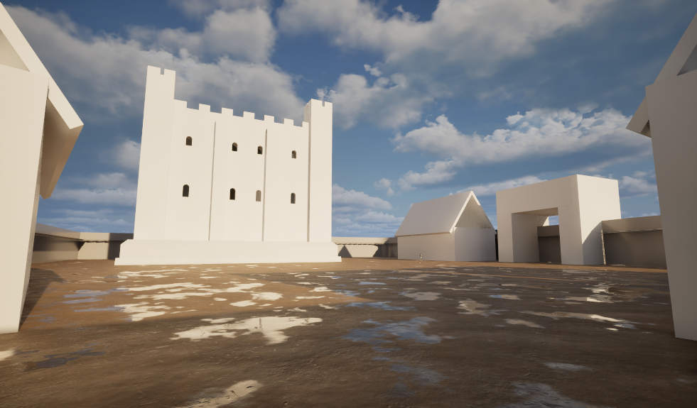
Screenshot of whitebox interior of Norman keep (courtesy of Mike Farrant)
The digital model is being made in Unreal Engine 5, a games engine that enables the development of detailed and immersive digital environments, and draws on existing excavation data. Using a games engine to create the reconstruction facilitates an enhanced user experience; people will be able to walk around the keep’s grounds, and up through the floors of the castle giving them an enhanced sense of place and scale. Additionally, environmental conditions can be included to simulate seasons, weather patterns and even the night time constellations that would have been visible on a given date in the 12th century.
Visualising Canterbury Castle aims to interrogate the potential of multidisciplinary expertise in developing digital heritage projects. To support this, the project’s methodology includes an iterative design process where subject-specialists* will take part in a series of four co-design sessions.
The first co-design session was held on May 22nd, and participants were able to explore a ‘whitebox’ version of the Norman keep and surroundings. ‘Whitebox’ refers to an early stage of a digital reconstruction where a structure’s overall form is created without surface textures, furnishings, or other fixtures. Participants explored the model using large touchscreens and were able to evaluate how the excavation information had been interpreted to date, provide feedback on the current user experience, and make suggestions for how the experience could be developed. The session demonstrated to both the project team and participants the benefits of simultaneously considering the historical data and the audience experience. As Dr Jeremy Ashbee, Head Properties Curator, English Heritage, explained:
I am very interested in how digital media combined with scholarship can be used to improve public access and comprehension of these sites, which even to people like me who have become obsessive about them for decades, still are beguilingly mysterious.
Screenshot demonstrating the development of the underlying user experience functionality including the camera rail system for climbing the staircases and the green travel nodes for touchscreen navigation. (Courtesy of Mike Farrant)
The next milestone for the project will be a public engagement event at this year’s Medieval Pageant and Trail (link) on July 5th where visitors of all ages will be able to explore the reconstruction on screens and provide feedback. Following that, the second co-design session will take place on July 16th.
The project team comprises Dr Katie McGown (Principal Investigator), Mike Farrant (Lead 3D artist), and co-investigators Dr Catriona Cooper, Prof Leonie Hicks, Sam Holdstock, and Prof Alan Meades whose combined expertise range from Norman History, Education, Digital Heritage, Exhibitions, to Games Design. To date, the project has recruited participants from organisations including English Heritage, Canterbury Museums, Canterbury Cathedral, Canterbury Council and Canterbury Business Improvement District.
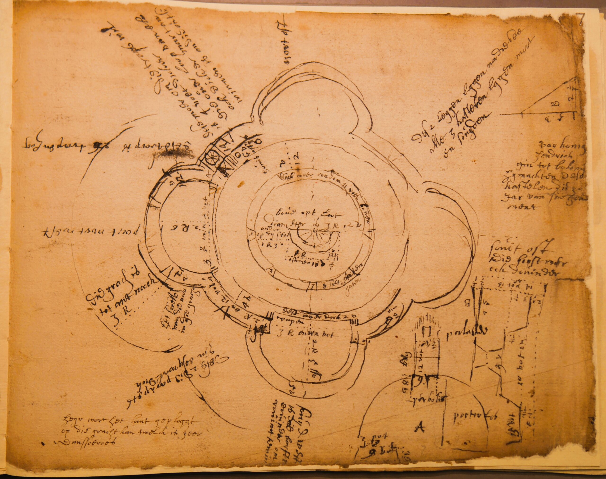
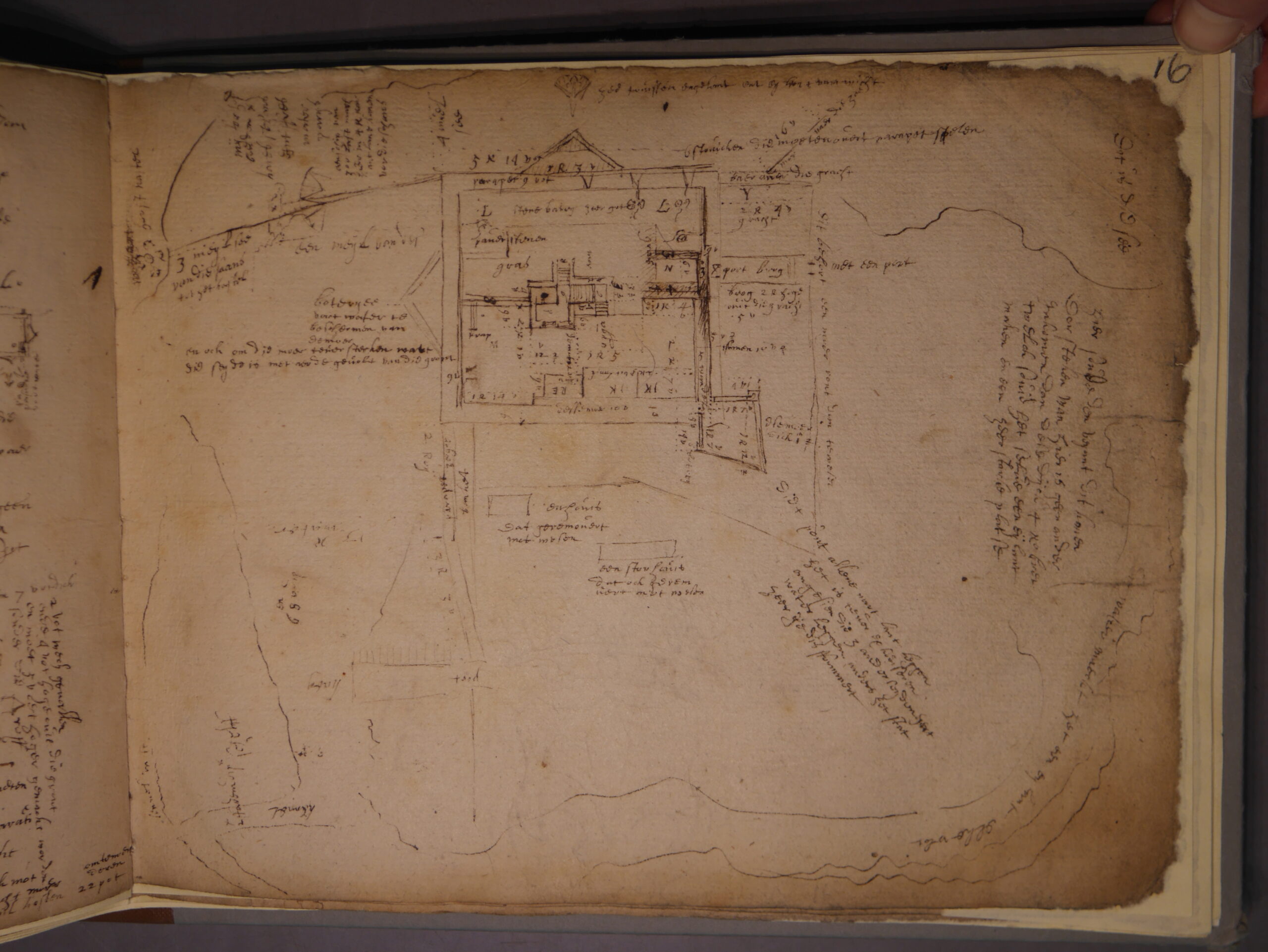
The Castle Studies Trust has awarded a research grant to Dr Esther van Raamsdonk (University of Utrecht, Netherlands) and Paul Pattison (English Heritage) to work on an early 17th-century manuscript from the National Archives, concerning fortifications and castles on the south coast of England.
The manuscript was discovered over 40 years ago by Charles Trollope, following which, the late John Kenyon published a preliminary assessment (Fort vol 11, 1983, pp 35-56), showing that it related to a survey of several coastal fortifications along the south coast of England, mainly those that originated in Henry VIII’s castle building programme in the 1540s. However, the manuscript is in Dutch, so as Kenyon rightly says: ‘translation of the Dutch is required to assess the document’s full significance and to possibly produce a more exact date than I am able to postulate at this moment’ (p. 37). His article examines some of the plans in the document, but there is no engagement with the Dutch text, which is more than 50% of the document. No transcriptions or translations have therefore been made before.
Sketch of Walmer Castle by the Dutch Engineer, courtesy of the the National Archive
The manuscript seems to be a surveyor’s on-site notebook, comprising fairly accurate and proportioned sketch plans. These beautiful drawings show a highly-skilled engineer at work, and one with a talent for exact survey drawings. These are supported by keyed notes and more detailed explanatory text. It covers most of the main fortifications and castles along the south coast, from Sandown Castle near Deal in Kent to Pendennis Castle at Falmouth in Cornwall.
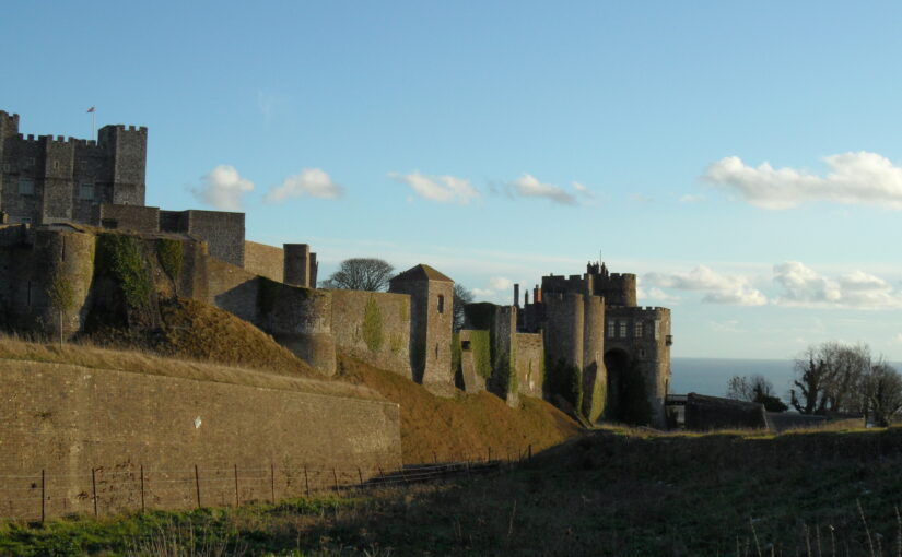
Walmer Castle today copyright English Heritage
Paul came across the manuscript several years ago and recently, prior to writing a new guidebook for Yarmouth Castle, Isle of Wight, looked for a palaeographer to transcribe and translate the pages for Yarmouth – enter Esther. Paul is a historic fortifications specialist, and his job is to help to make sense of the translation, as the conversion to English is not always obvious: there are many military and technical terms and sometimes the meaning is not immediately apparent. However, the sketched plans are annotated and keyed, which should help in understanding specific parts of each fortification. Esther is an expert palaeographer, having taught early modern English palaeography courses for some years, and scholar of 17th-century Anglo-Dutch relations. The grant is towards her costs of transcribing and translating the text and notes. It is not an easy task. The hand is a difficult one and several pages are faded. The Dutch engineer spent some time in England and the result is a hybrid language, a phonetic (for Dutch readers) spelling of English words. The document also functioned as a shorthand for the author, using non-standard abbreviations, idioms, and little drawings. The exercise is therefore not of a straight-forward transcription but requires quite a bit of puzzling.
As mentioned, we used the Yarmouth example to see what information we could gather from the manuscript. From this test case we know that the surveyor was commenting on condition and making recommendations for repairs and changes. Because of the detailed map and key, we could pinpoint the function of some rooms that were hitherto unknown. We look forward to see what further secrets the document will reveal about the other buildings.
The funding will enable us to examine a sample of the manuscript covering several sites in the Cinque Ports area of jurisdiction – Sandown, Deal, Walmer, Dover, Sandgate and possibly Camber. All of these are well known to Paul, and it is hoped that significant details about the condition of each castle or fortification will be forthcoming, for comparison with other contemporary accounts in English, to see and understand where this survey fits and whether or not it resulted in any repairs or additions on each site. John Kenyon thought it might date to the 1620s: we would like to try and confirm that, or otherwise, by comparison with earlier and later surveys, and to establish the political context for its commissioning. This will lead to at least one provenance article. The transcriptions (some of which will be published) will also provide a very valuable snapshot of the south coast fortifications 80 years or so after their creation, and form a test for the usefulness of going further and transcribing the whole manuscript. There is an exciting journey ahead.
The Castle Studies Trust is delighted to announce the award of five grants, totalling a record amount of £42,000, to a wide range of projects with different types of research. The amount means that since our foundation we will have given over £300,000 to castle research projects – a landmark to celebrate.
Canterbury, Kent: To create an interactive digital model of the castle’s keep. The keep is one of the largest surviving from early Norman England dating to the late eleventh / early twelfth century. Now much ruined and inaccessible to visitors due to instability, the project will use the findings of previous archaeological research to create an interactive model. Work will start in March and be completed within ten months.
Clavering Castle platform copyright Simon Coxall
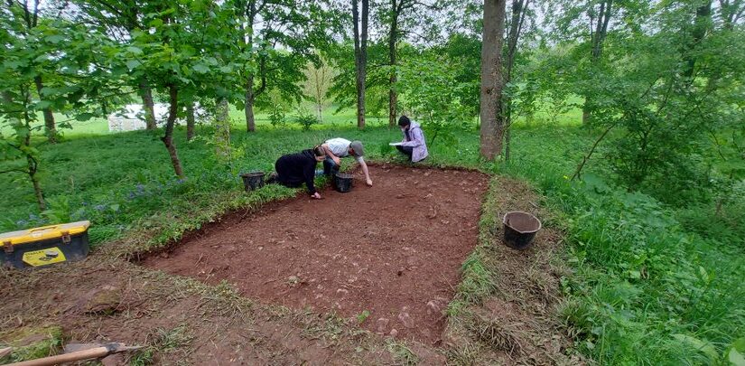
Clavering, Essex: To fund an excavation to help understand the development of the site which was occupied for over 600 years and which could be one of the very few pre-conquest castles in the UK. The excavation will build on the extensive survey work carried out by the local group of the site. They are planning to do the excavations in June.
Crookston Castle copyright Friends of Crookston
Crookston, Glasgow: A community-led geophysical survey, using multiple techniques, through which the Friends of Crookston Castle in conjunction with HES hope to learn more about Glasgow’s only castle. While the standing remains are believed to date from the early fifteenth century, it is believed that the castle dates back to the twelfth century. The group hopes to discover evidence of that earlier history and whether it was based on an earlier Iron Age hillfort. They plan to do the survey in early August.
Knepp Castle copyright Richard Nevell
Knepp, West Sussex: An excavation building on a geophysical survey to better understand the site’s development and its relationship to the local area of this important baronial centre thought to be built by the de Braose family. The first documentary evidence is from 1210 when it was under royal control, documenting repairs, while the geophysical survey shows activity that pre-dates the extant stone tower. Excavations are planned for late July/ early August 2025.
Image of Transcript copyright Esther van Raamsdonk
Transcription and translation of C17 Dutch Engineer’s Survey of English castles and fortifications: A joint project between Dutch academic Dr Esther van Raamsdonk and English Heritage to transcribe and translate part of an early seventeenth-century manuscript of a Dutch surveyor’s examination of castles and forts in England. The sample covers five of the 22 castles and fortifications in the document, which is called SP 9/99, held by the National Archives in Kew. The sample will include Dover, Walmer and Deal. The document is filled with detailed drawings and maps of these fortifications with often lengthy descriptions of their condition. Esther has already started work on it.
Dr Ryan Prescott, project lead, looks at what the excavations at Newhouse have uncovered, now the final report is in.
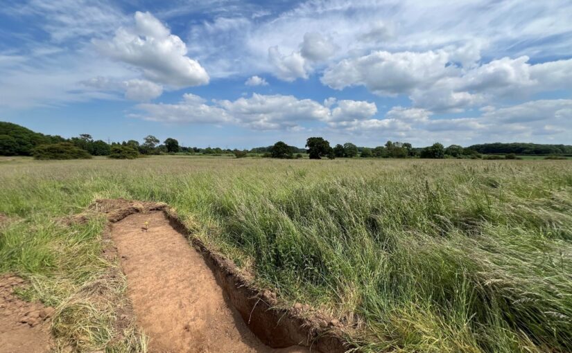
In June 2024, a team from Humber Field Archaeology completed a trial excavation at the presumed site of Newhouse Castle in Brocklesby, North Lincolnshire, generously funded by the Castle Studies Trust. The fieldwork, which followed a geophysical survey conducted in 2023, aimed to uncover evidence of the castle which was soon replaced by a monastery during the period known as ‘The Anarchy’. The results of the excavation, now available in the post-excavation report, have provided fascinating insights into the site’s more complex history.
Two trenches were carefully excavated, revealing a narrative that spans many more centuries than what had previously been understood about the site:
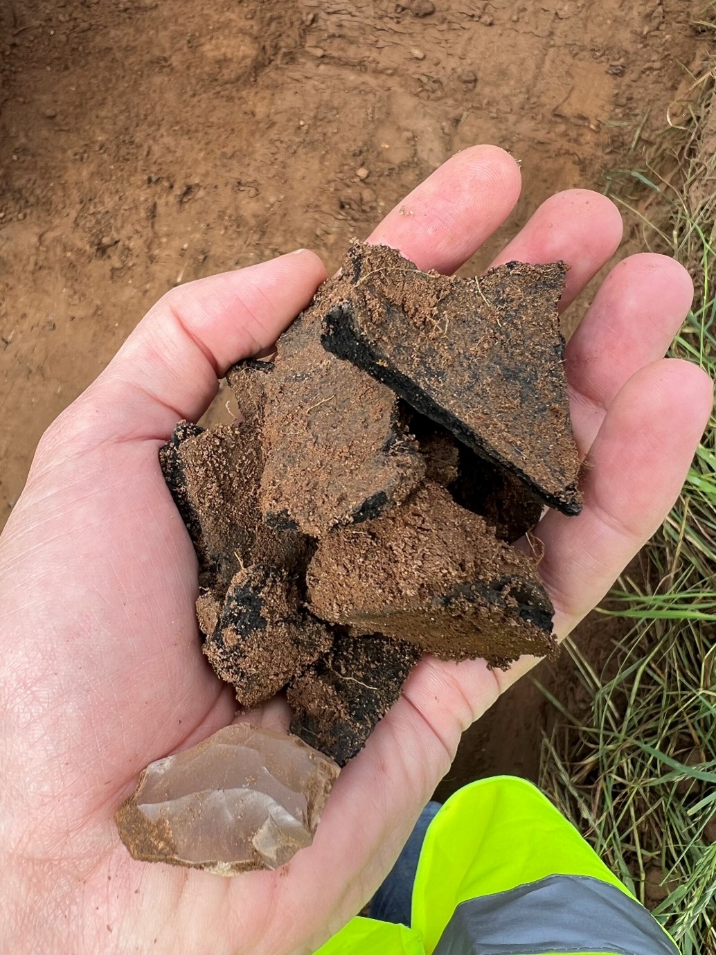
Prehistoric Activity: Flint tools and pottery fragments hinted at Neolithic and Bronze Age activity, suggesting the site has held importance for millennia.
Anglo-Saxon Origins: A potted cremation burial, complete with grave goods like a knife and a decorated glass bead, was unearthed in Trench 1. This burial, dating back to the mid-6th century, suggests the site was already significant long before the construction of the castle and abbey at Newhouse. Nearby, leather and woven textile fragments were recovered, providing a rare glimpse into the craftsmanship of the era.
Medieval Ditches: Sections of a moat-like ditch encircling the earthwork were excavated. Their sharp cuts and rapid infilling suggest limited use. Although devoid of finds evidence (very frustrating!), a post hole was recovered near to the ditch within the interior of the earthwork, possibly tied to the short-lived history of Newhouse Castle.
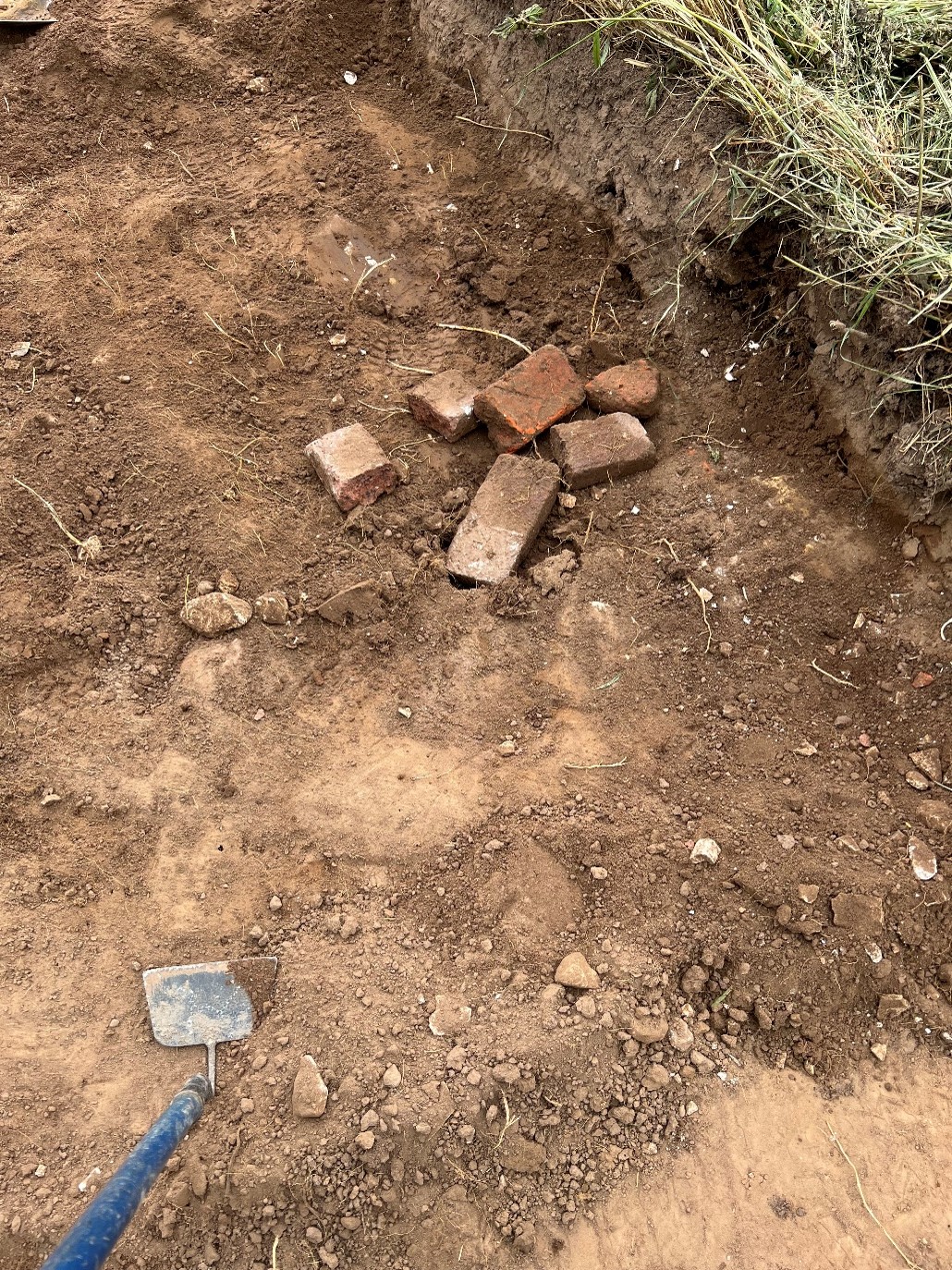
Post-Medieval Activity: Traces of later use included 17th-century brick deposits, potentially linked to landscaping efforts attributed to Capability Brown when it would appear that material was moved across the site in this new phase of occupancy.
Pottery fragments and flint tools show how the site was occupied long before the mid-twelfth century.Early Modern brick assemblages underline the continued use of the site following the Dissolution of the Monasteries.
Summary
The findings from Newhouse underline the site’s long-term occupation and its ongoing significance in the landscape of North Lincolnshire. Although no definitive structural remains of the castle were identified (this was always going to be tricky!), the excavation enhances our understanding of how the site evolved—from its prehistoric roots, to its medieval prominence, and beyond.
The full post-excavation report is now available, offering a detailed account of the discoveries and their importance. Perhaps inevitably, we have sparked potentially more questions than answers. However, we have nonetheless helped to advance the debate and our understanding of this intriguing site. We extend our gratitude to the Castle Studies Trust for their support.
The final report is on the project page of our website.
The deadline for grant applications passed on 29 November. We’re going through the various projects now. Altogether the 13 projects, coming from all over Britain, are asking for over £84,000. They cover not only a wide period of history but also a broad range of topics.
We will not be able to fund as many of these projects as we would like. To help us fund as many of these projects as possible please donate here:
In a little more detail here are the applications we’ve received:
Cainhoe, Bedfordshire: Through various forms of media such as reconstruction drawings, models and generative AI video and prints, the Greensand Trust aims to provide visitors and educational groups with a better understanding of what this motte and bailey castle looked like, the lived experience there and why it is significant.
Canterbury, Kent: To recreate an interactive digital model of the castle’s keep. The keep is one of the largest surviving from early Norman England dating to the late eleventh / early twelfth century. Now much ruined and not accessible to visitors due to instability the digital reconstruction will use the findings of previous archaeological research to create an interactive model.
Castle Sinclair Girnigoe, Caithness: The castle was the principal seat of the Sinclair Earls of Caithness and was built between the fourteenth and fifteenth centuries. The application is to help publish the results of the archaeological research carried out during the emergency stabilisation of the site between 2002-2011. The grant will be to fund both ceramic and clay pipe analysis as well as some illustrations.
Chester, Cheshire: To create reconstructions of the inner and outer wards of Chester Castle as it may have looked in its heyday to add to the one currently being prepared on the Agricola Tower. Chester was one of the major castles of the Welsh Marches and was the base for Edward I’s campaigns in Wales.
Clavering, Essex: To fund an excavation to help understand the development of the site which was occupied for over 600 years and which could be one of the few pre-conquest castles in the UK. The excavation will build on the extensive survey work carried out by the local group of the site.
Cockermouth, Cumbria: Dating from the mid twelfth century this large northern baronial fortress has seen many periods of development but its evolutionary history has never been subject to systematic or formal assessment. The project will focus upon developing a detailed understanding of the physical fabric of the castle’s superstructure.
Cooling, Kent: Co-funding the creation of a model of Cooling Castle gatehouse. The castle gatehouse is scheduled at Grade 1 by Historic England underlining its importance. The Gatehouse was constructed by Thomas Crump on behalf of Sir John de Cobham in the fourteenth century. The design is interesting in that the towers are horseshoe shaped with no apparent back to them and were one of the first places to incorporate gun loops.
Crookston, Glasgow: A community-led geophysical survey, using multiple techniques, through which the Friends of Crookston Castle in conjunction with HES hope to learn more about Glasgow’s only castle. While the standing remains are believed to date from the early fifteenth century, it is believed that the castle dates back to the twelfth century. The group hopes to discover evidence of that earlier history and whether it was based on an earlier Iron Age hill fort.
Dundonald, Ayrshire: To fund a building survey of what is thought to be primarily the late fourteenth century remains of this baronial castle and perhaps reveal any evidence of the early thirteenth century castle. In addition the grant will help fund community outreach to explain the results.
Ellesmere, Shropshire: Geophysical survey of the large motte and bailey castle in Shropshire which prior to June 2024 had never been surveyed before when the large motte was surveyed by GPR which revealed possible buildings. The resistivity and magnetometry surveys would confirm that, as well as survey the rest of the site which played an active part in the Marcher disputes in the reign of Henry III.
Knepp, West Sussex: An excavation building on a geophysical survey to better understand the site’s development and its relationship to the local area of this important baronial centre thought to be built by the de Braose family. The first documentary evidence is from 1210 when it was under royal control, documenting repairs, while the geophysical survey shows activity that pre-dates the extant stone tower.
Picton, Pembrokshire: To create a detailed reconstruction of the castle as it was first built in the early fourteenth century. This will be largely based on the detailed survey work the Trust funded in 2023.
Translation of C17 Dutch Engineer’s Survey of English castles and fortifications: A joint project between Dutch academic Dr Esther Raamsdonk and English Heritage to do a sample translation of five of the 22 castles and fortifications surveyed in a document called SP 9/99, an early seventeenth-century manuscript of a Dutch surveyor’s examination of the sites, held by the National Archives in Kew. The sample will include Dover, Walmer and Deal. The document is filled with detailed drawings and maps of these fortifications with often lengthy descriptions of their condition.
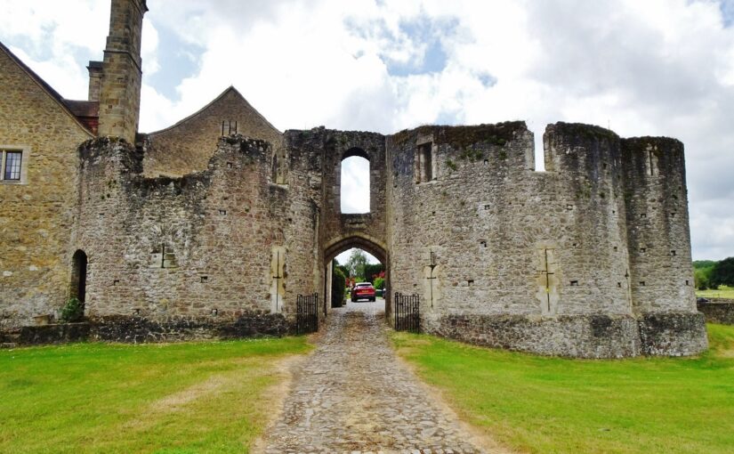
Starting on 8 October 2024, Philip Poucher of Heneb – Dyfed Archaeology (formerly Dyfed Archaeological Trust) will carry out a laser-scan survey of the gatehouse at Leybourne Castle, near Maidstone in Kent. The survey will be supported by a full programme of research by Neil Ludlow who outlines the importance of such a survey.
A small baronial castle, picturesquely sited on a low bluff above the village church, Leybourne has been occupied since it was built in the 11th or 12th century, and is still a private family home. It is not generally open to the public and no structured recording has so far taken place, while no accurate site drawings exist. The work, which is wholly-funded by the Castle Studies Trust, will fill this gap and greatly improve our understanding of this important site.
Fig. 1: Leybourne Castle – the gatehouse from the exterior. Present house to left, latrine turret to right. Copyright Neil Ludlow
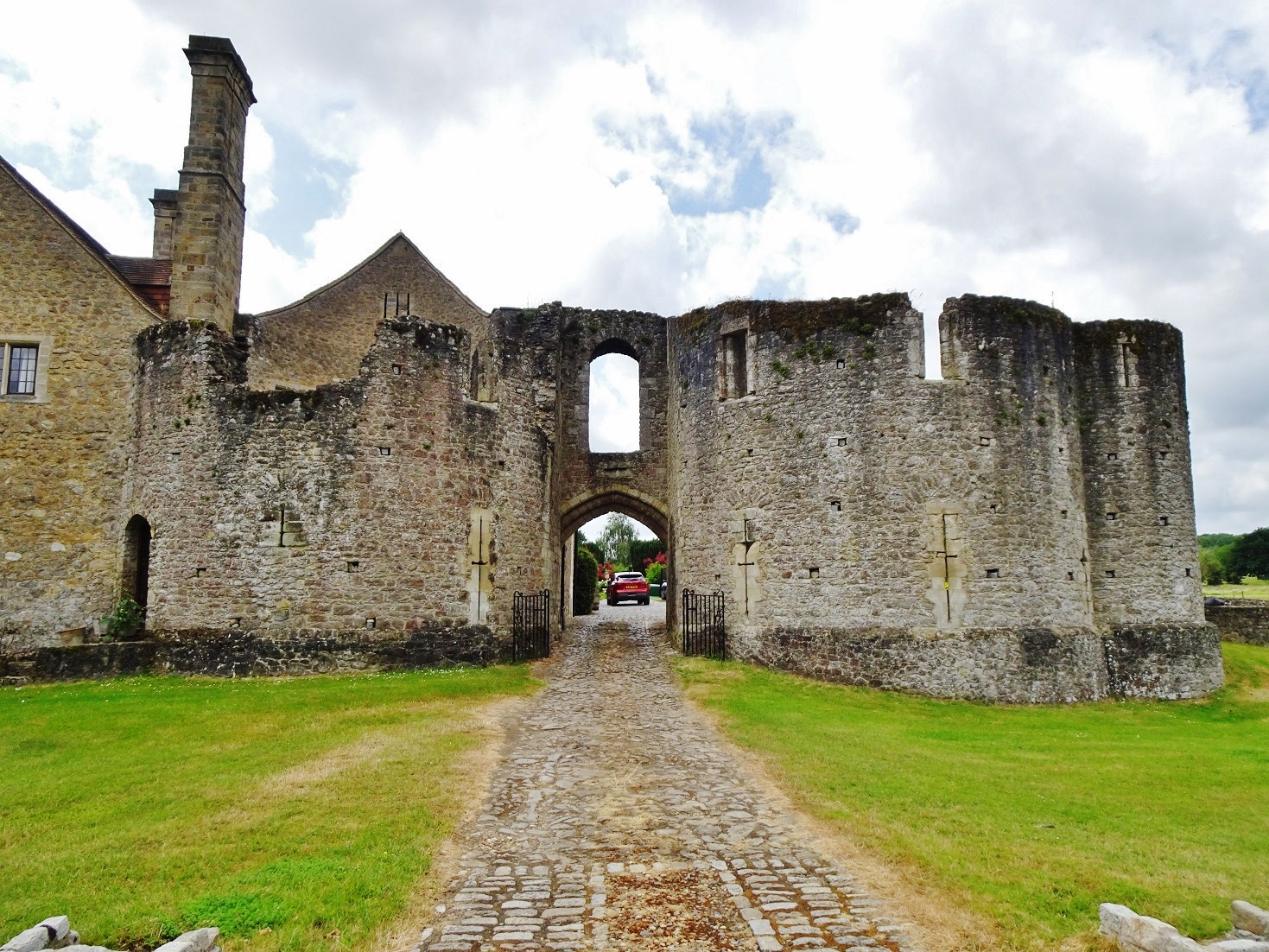
Beginning as a circular ringwork of around 0.12 hectares, Leybourne was later given stone defences, with a gatehouse that still dominates the castle. Centuries of alteration have masked much of the rest of the surviving stonework, but the present house – heavily restored during the 1930s in the Arts-and-Crafts manner – is built around the core of the medieval hall and chamber-block. A further building is thought to have been the chapel, while there are the remains of at least one other mural tower.
Fig. 2: Leybourne Castle – the gatehouse from the interior. Latrine turret to left, present house to right. Copyright Neil Ludlow
The date of these works is still uncertain. Our only record is from 1266, when King Henry III granted 4000 freestones to Leybourne’s lord, Roger de Leybourne. They are normally thought to have gone towards the defences, but these are entirely of rubble construction suggesting that the freestone may instead relate to an upgrade of the domestic buildings. So the key to understanding the development of the defences is the gatehouse, which despite alterations through time, and the loss of its rear half, is substantially as built. Nevertheless, its precise form has never been properly established – published accounts are based on drawings produced by Sidney Toy, in 1927, which are somewhat misleading in many important details.
The gatehouse is of unusual design. It has been regarded as transitional between the simple twin-towered gatehouses of the early/mid-13th century and the more complex structures of the late 13th century onwards, but appears to be somewhat later. It is two storeys high, with D-shaped towers flanking a narrow gate-passage that was formerly rib-vaulted. The entry lies beneath a high outer arch and is deeply set back between the towers, characteristics that were both introduced, in Wales, during the 1280s. And the entrance arch lies beneath a horizontal chute outlet, somewhat like a letterbox in outline. This is a feature of debatable function, but which was notably employed at Caerphilly Castle by Gilbert de Clare in the 1270s. In addition, the gatehouse towers are of unequal size and projection, as in the Clare’s gatehouse at Llangibby Castle (Monmouthshire), probably built c.1307-14, while both gatehouses show a D-shaped flanking latrine turret. Incorrectly shown by Sidney Toy, it lies parallel to the towers at Leybourne, unlike Llangibby where it projects at right-angles. And while the arrowloops at Leybourne were restored as fully-oilletted ‘Clare-style’ cross-loops in Toy’s drawings, alteration during the 18th and 19th centuries has in fact masked their original form and the evidence for any original oillets is questionable.
Fig. 3: Leybourne Castle gatehouse – the ‘letterbox’ chute.
So the gatehouse has a highly individual design, which is of international significance. While it may largely be down to personal choice by its patron and master-mason, at least some influence from the Clares is unquestionable. This may have emanated directly from the Clares’ nearby centre at Tonbridge, but Welsh aspects of the Leybourne design may point towards additional input via an intermediate lord such as William de Valence, who also used ‘Clare’ motifs and was very powerful both in Wales and in this part of Kent. At any rate, the combination of features suggests a date long after 1266 and probably in the early 14th century – perhaps under Roger de Leybourne’s son William, or his grandson Thomas, between c.1300 and 1310. However, on current evidence much of this is speculative: these are the key questions the project will seek to answer, in addition to producing survey data.
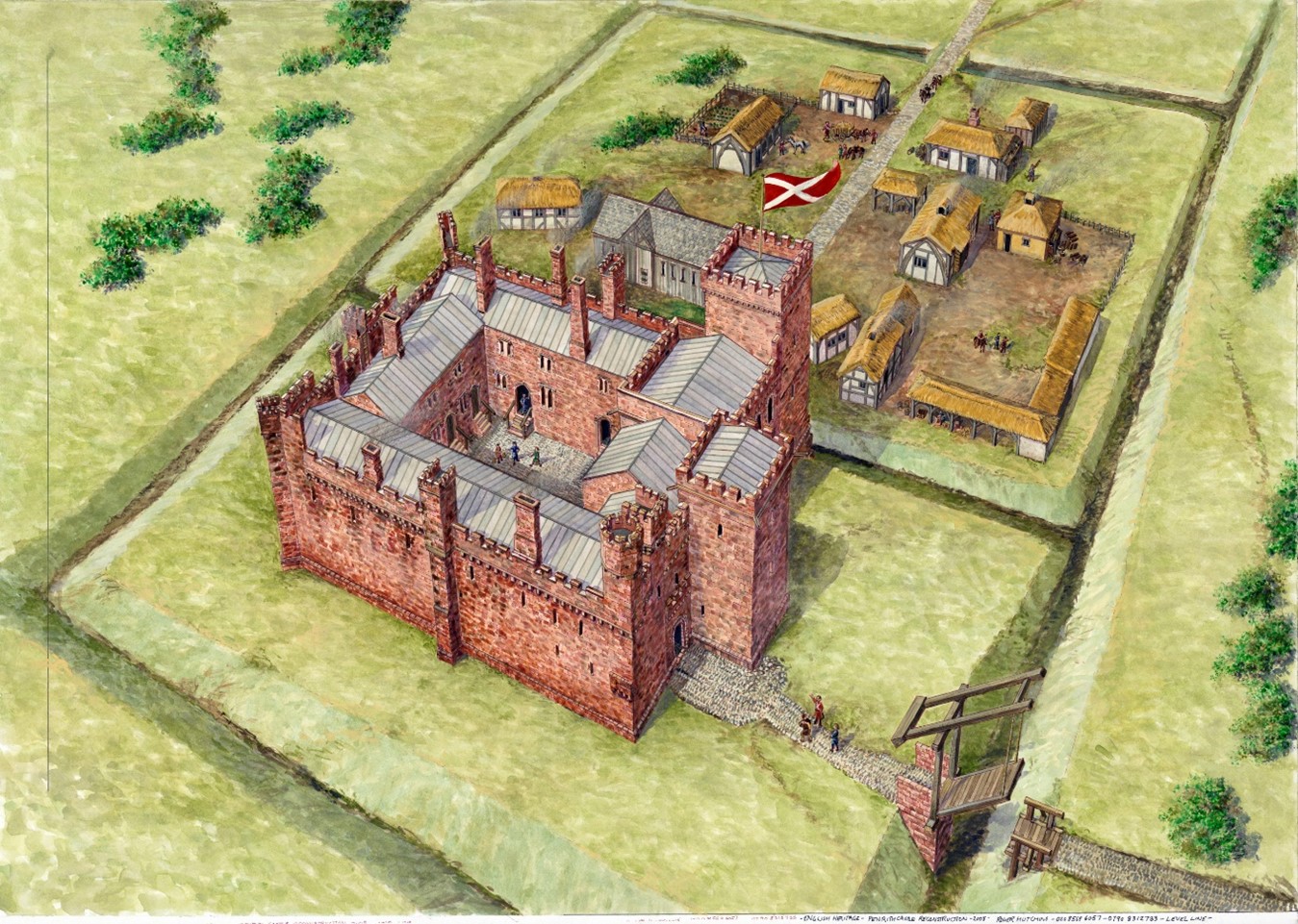
English Heritage is pleased to be a recipient of a generous grant from the Castle Studies Trust to create a new reconstruction image of Penrith Castle (Cumbria, England). Grant co-awardee Will Wyeth (Properties Historian, English Heritage) discusses this work in the context of the charity’s ambitions for public history.
The castle of Penrith, made of striking red stone, is arranged in four roughly equal ranges bounding a central off-square courtyard. Of the two towers there survives, the Red Tower retains its north-east wall and, and the White Tower a vaulted ground-floor chamber.
Scholarly consensus ascribes three major phases of construction in the castle: a primary phase of the very late 14th century and two 15th-century phases, the latter of which was the more extensive. It is this last phase, credited to Richard Duke of Gloucester, which is the focus of the reconstruction image.
The castle today is thoroughly urban, and sits within a public park popular with residents and visitors alike. There are several panels offering information about the castle, including an aerial reconstruction of the site in the mid-15th century.
The existing reconstruction remains an excellent image. The ranges and towers are carried to full height, the lost courtyard is rebuilt and populated with buildings, while tiny human figures are visible across the site. However, as with many aerial reconstruction images, it has limitations as a device for public history. The image does not aid site orientation for visitors unfamiliar with the ruins or Penrith proper; and life at a human scale is difficult to imagine.
The new reconstruction aimed to address these limitations as well as draw in a further source of guidance. The work of looking after and developing the public history of English Heritage’s properties is supported by a worthy army of volunteers. Penrith Castle is lucky to have one such volunteer, Joanna, who is a true steward of the site’s public history and has led several tours of the castle, gathering feedback on visitors’ responses to it, and the available interpretation. Through Joanna’s experience, we realised we needed a new image, and imagining, of the castle and its everyday inhabitants.
It was necessary to start the process of identifying spaces in the castle from scratch. Several 16th-century surveys mention buildings and spaces with attendant measurements, but the detail is misleading. The missing portions of the site fabric today prohibit confidently identifying spaces such as a hall, chamber, kitchen, accommodations, etc. Certain architectural features survive which can help, but a convincing and comprehensive reconstruction was not achievable.
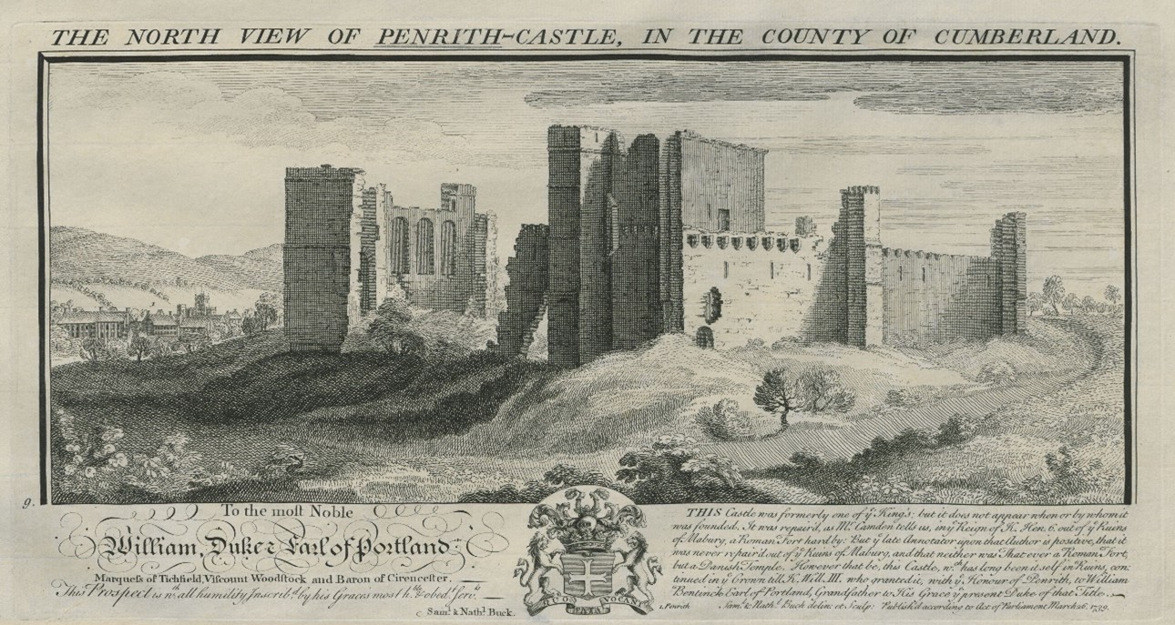
Figure 3. Buck brothers’ image of Penrith Castle, 1739. The segment of walling on the left with three tall round-headed windows probably depicts a better-surviving portion of the column of stone in Figure 1. In the centre of the image is the tall block (tower?) positioned on the western corner of the castle, now almost completely lost.
Some early images help to locate specific buildings. The Buck image of the castle (1739) illustrates the castle in a more complete state than today – including a complete section of walling where only the reveals and partial window-head of the ‘hall’ survives today – but it also testifies to the presence of a lost tall block positioned on the castle’s west corner (Figure 4).
The great hall was identified by the tall windows in Bucks’ image. This is an unorthodox position. It was unusual for a great hall to be positioned so close to the formal entrance to the castle (in the hall’s primary phase, positioned at the east end of the south range; in Gloucester’s time, just west of the hall). The kitchens which serviced it were also on the other side of the enclosure.
Other ideas were mooted. The presence of a chapel identified with some confidence at the upper level of the east corner of the castle precluded identification with this space in that capacity (see Figure 1). It is possible the three-windowed space was a private or state chamber. While feasible, this pushes the necessity of a great hall elsewhere in the castle where there is not space for it. The high wall outer wall of the surviving south-east range has few outer windows of any significance; the south-west range was, it would seem, dominated by the large tower depicted in the Bucks’ image and resting upon masonry identified with Gloucester’s work; while the north-west range in Gloucester’s time had a number of fireplaces at ground floor whose flues would rise through a first-floor hall set above them, making this alternative, hypothetical arrangement unlikely. For want of alternatives the present consensus, that that hall was in the positioned identified by the Bucks’ three-window wall, is probably correct.
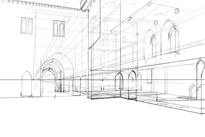
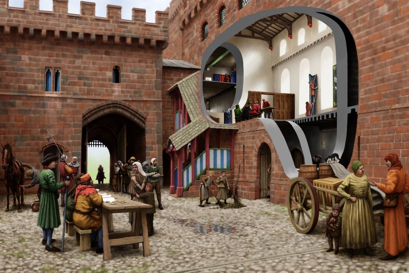
The new image was developed in collaboration with artist Pete Urmston from an existing photograph (Figure 4, left). This captured several parts of the site which we wanted to reconstruct – the great hall with access stairs, Red Tower and parts of the Gloucester-era gatehouse. It incorporates the part of the castle most familiar to passers-by – the Red Tower – and an assemblage of standing features which in general visitors find difficult to understand. This perspective also granted greater flexibility to create scenes of human interaction in the foreground of the image which might populate the castle and convey a sense of Penrith’s medieval community.
Figure 4. Base photograph used for reconstruction (top); first draft of reconstruction (bottom). Note the column of stone on the left image with window reveals is replicated (rebuilt) on the right.
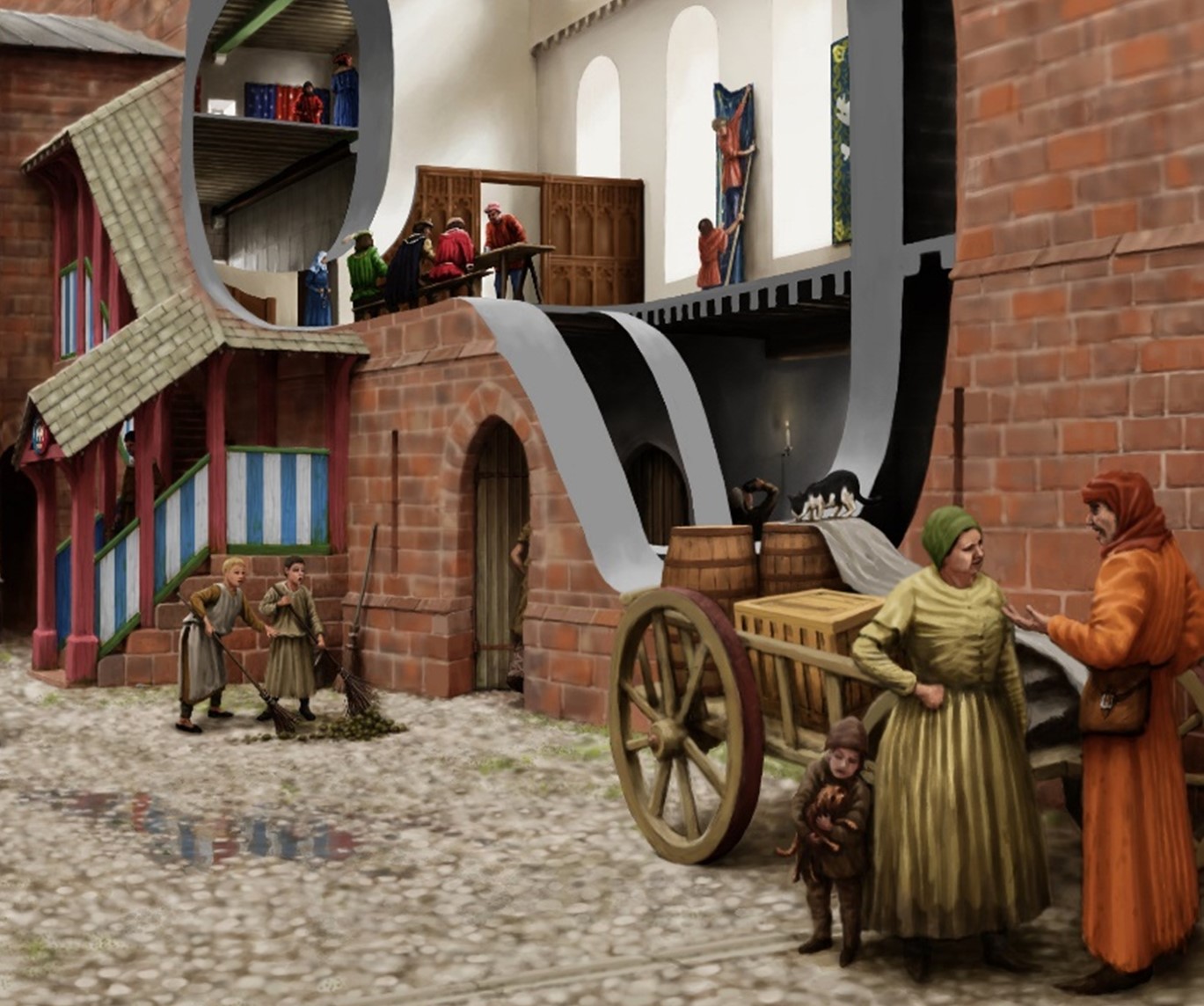
The process of reconstruction begins with a line sketch superimposed upon the base photograph (Figure 4), and hereafter a sequence of amendments and insertions ultimately leads to the final image (Figure 5). The cutaway into the great hall, and beyond into the Red Tower, gives some sense of the grandeur and scale of lost interiors. The clerestory in the hall, inferred from antiquarian sketches and some degree of analogy with that at Middleham Castle, is defined by windows set on a wall carried by a projecting corbel table. A two-door timber screen of late 15th-century design covers off the lower part of the hall. The window-heads of the gatehouse first-floor echo surviving dressed stone fragments found at Penrith.
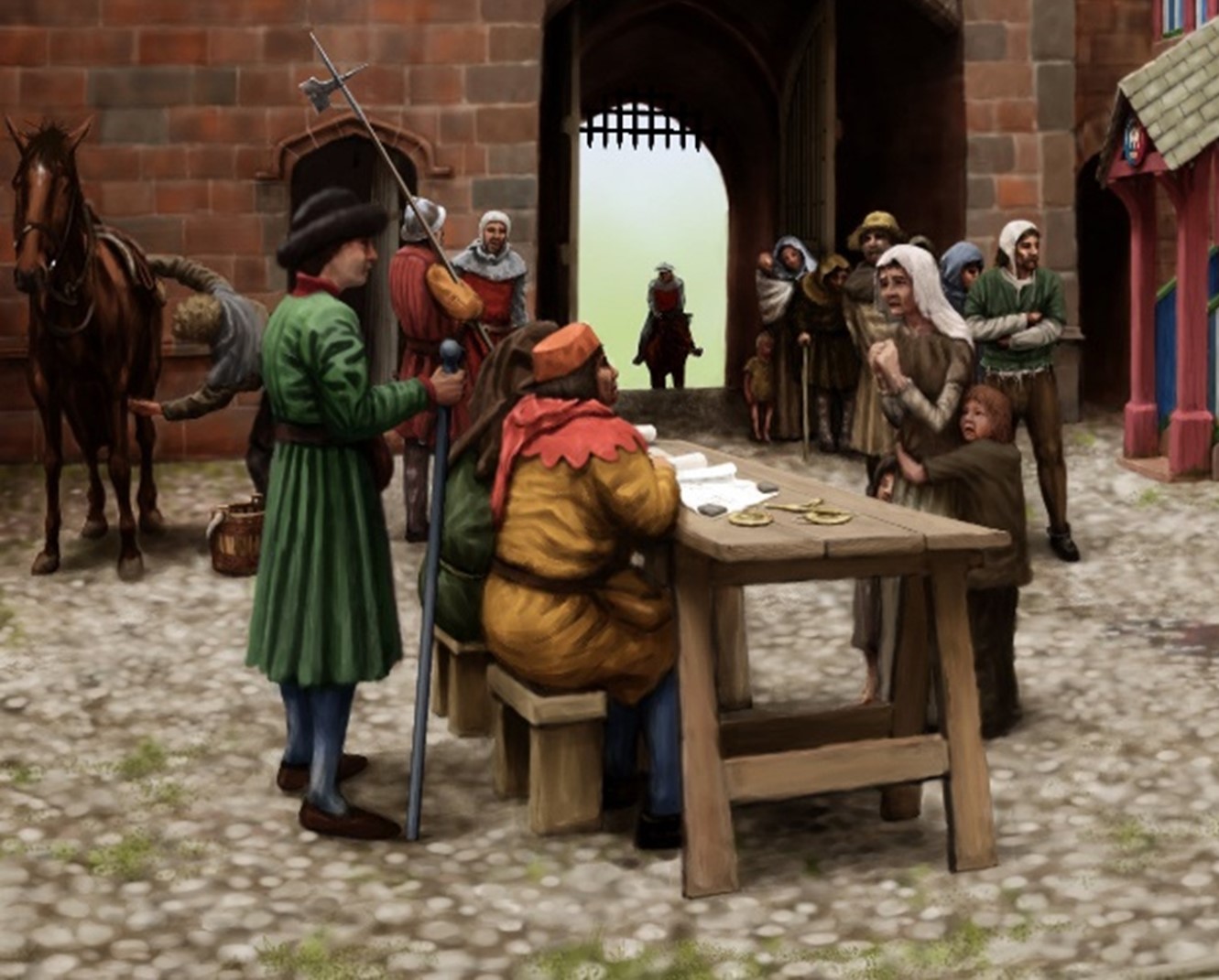
Perhaps most significantly, the castle is populated with a scene from its tenure by Richard of Gloucester – a meeting of castle staff with tenants and poor folk to hear pleas. A single figure who is attested at the castle and whose presence would be in keeping with a day-to-day scene in castle life in the late 15th-century is represented: Sir Christopher Moresby, depicted on the far left standing with a staff and wearing a green coat (Figure 6).
Moresby supervises under-stewards seated on stools and by a trestle table. Just in front of the restored stair block where a figure descends, painted in Gloucester’s colours of white and blue, are two boys sweeping the yard (Figure 7). Their attention has been captured by a black and white cat standing on top of some barrels. Behind them, through the cutaway, are two figures in the hall basement. One is just entering while the other is sampling (perhaps illicitly) the stores of ale.
In the hall at first floor are three parallel scenes: well-dressed figures are assembled on a long bench and trestle table in the hall proper. A woman enters the screened area at the low end of the hall from the buttery in the first floor of the Red Tower, visible through the inner cutaway. Leaning upon the sole standing piece of wall that survives in this space today, two servants are bringing down a blue hanging.
The new reconstruction aims to place the people of Penrith Castle at the centre of its re-imagination, while bringing back its lost buildings and interiors. In time the image will feature on a new panel scheme in the castle. In the immediate short-term, Joanna the volunteer is already armed with the image and sharing the new light it brings to the castle with visitors.