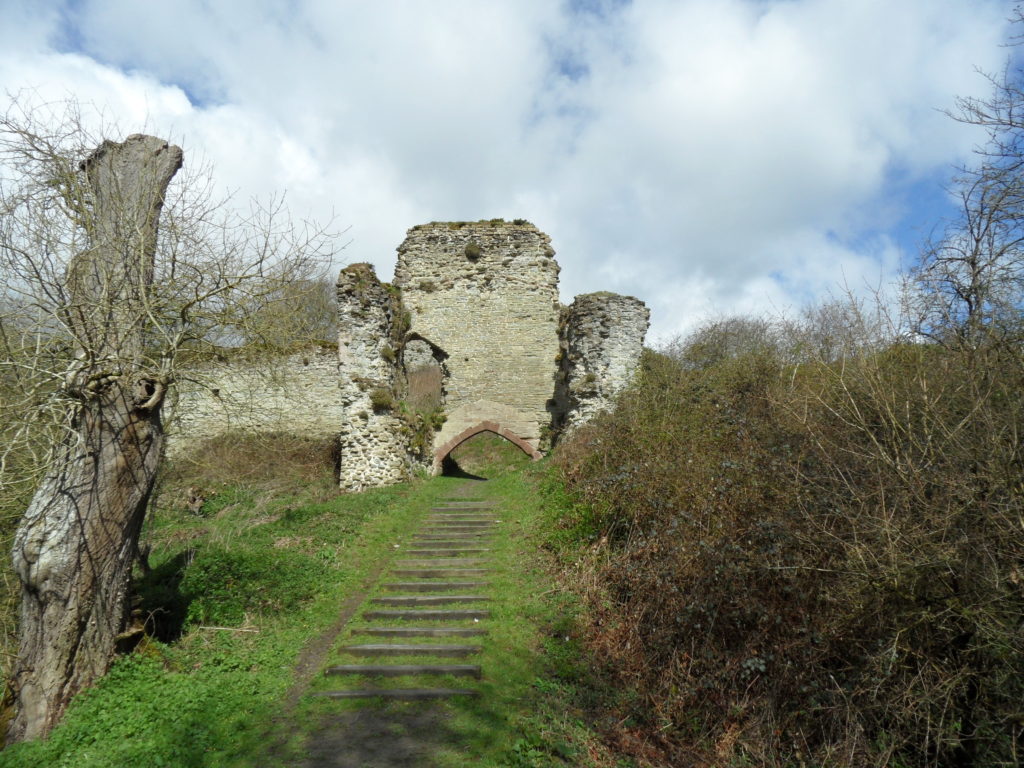
Dr Peter Purton, FSA, Castle Studies Trust trustee and author of recent works on medieval sieges and medieval military engineers looks at his latest area of research, later medieval fortifications and the impact of the introduction of gunpowder.
Castle studies were once ruled (in England at least) by wealthy amateurs, mostly male (Ella Armitage a stand-out exception) and many with military backgrounds. Every aspect of a castle, for them, was determined by military thinking. The late twentieth century counter-attack turned this on its head, stressing the symbolic role of castle-building as expressions of status and power. Some people challenged any suggestion that changes were driven by the need to upgrade defensive capability; and the same argument has been applied when guns arrived on the scene.
Those keen to argue the superiority of the English can always point to the first adoption (in Europe – the Chinese were centuries ahead) of gunpowder, and its first use for war. It’s also true that the English were the first to adapt fortifications to use guns, from the mid-fourteenth century, a little ahead of the Low Countries followed by the French, all places affected by the devastating impact of the struggles we bundle up in the title of the Hundred Years war (1337-1453).
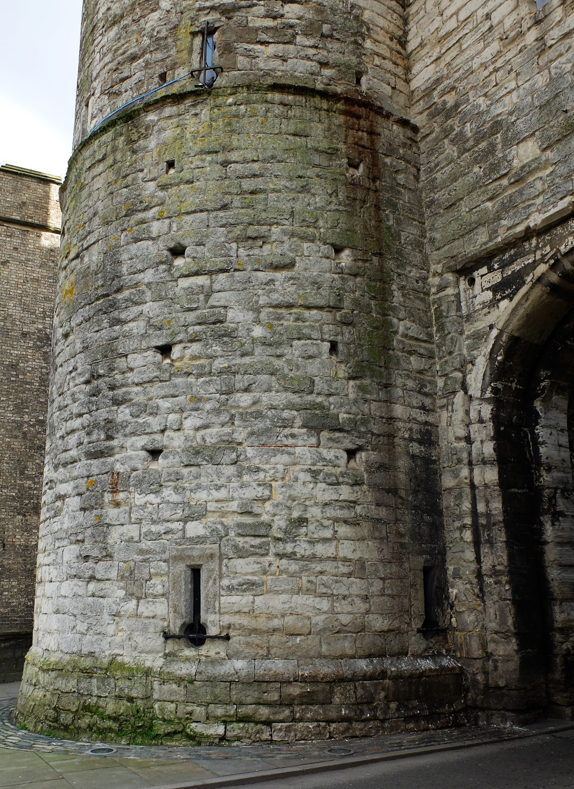
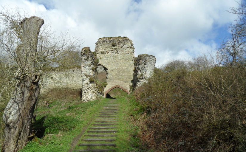
Gun loop at the west gate of Canterbury, Kent
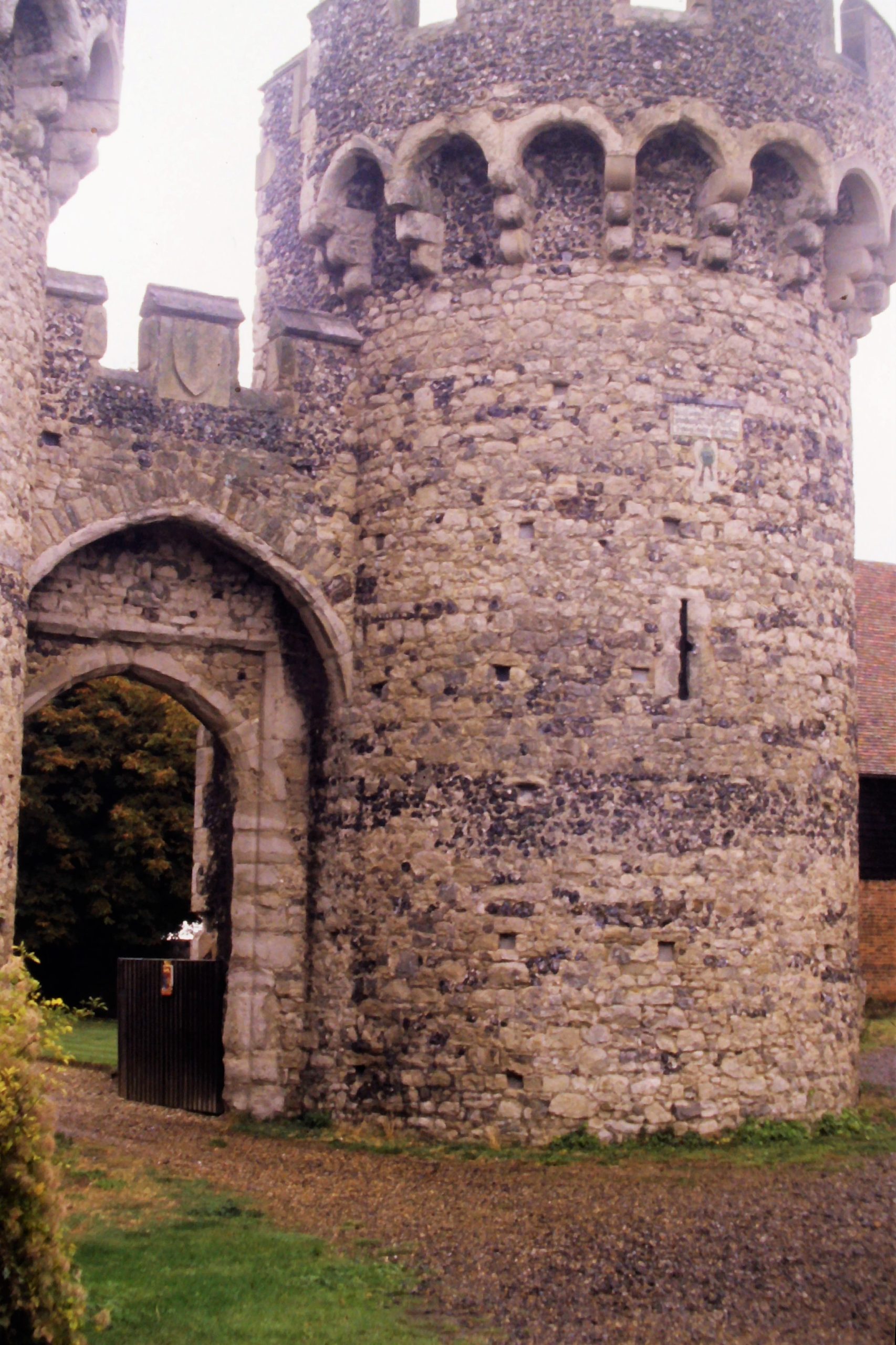
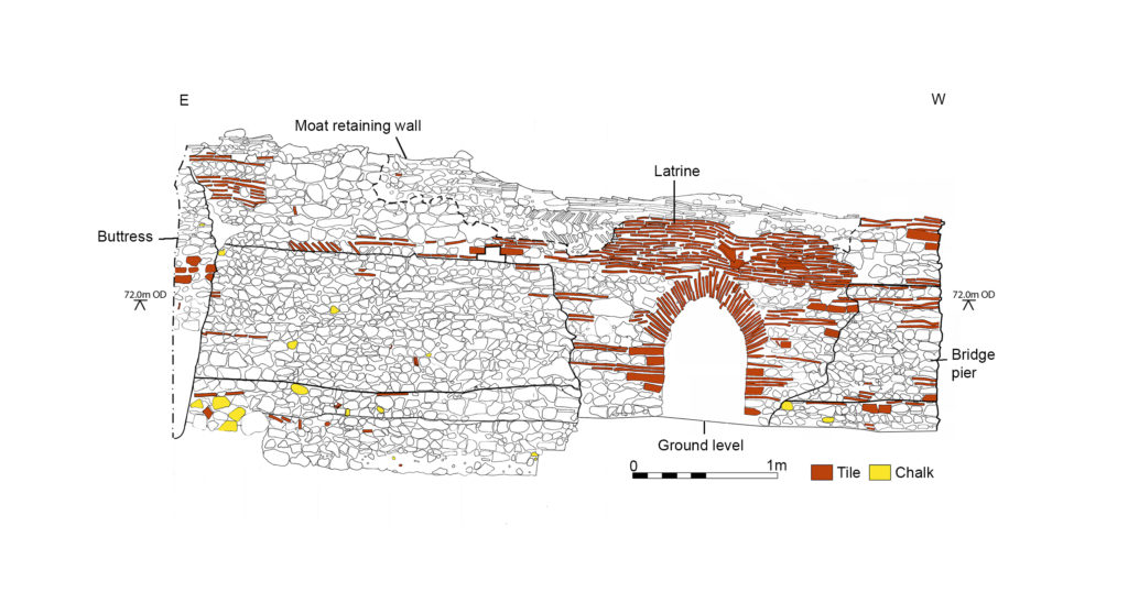
Were loops created for guns also symbolic? If you take account of the historical reality of the time, this argument surely evaporates in a puff of (gun)smoke. I’m working on a new history of changes in fortification in the age of gunpowder with Dr. Christof Krauskopf and we delivered a paper at the (virtual) Leeds IMC in July 2020 addressing this question. We can’t answer the question without knowing the context, and what the builder wanted. The first is usually evident, the second is irretrievable. Across southern England from the earliest days of the war there were frequent seaborne raids by the French and their allies that caused local devastation and serious embarrassment (and loss) to the English crown. People could not know when and where the next attack would come. The response was the preparation of defences designed to use guns (at the time, they were not powerful enough to harm stone walls) from East Anglia (the Cow Tower of Norwich, for example) to Devon (Hawley’s Fortalice at Dartmouth), usually adapting existing defences but often building anew. The royal ‘architect’ (an anachronistic shorthand) Henry Yevele was directly involved in the erection of the Westgate and the reconstruction of the city walls at Canterbury and at private castles in Kent (Cooling, for example). Southampton, having been burnt to the ground by the French, underwent extensive reconstruction of its defences, including (early in the fifteenth century) one of the first gun-towers (the God’s House tower).
Cooling Castle, Kent, Outer Gatehouse
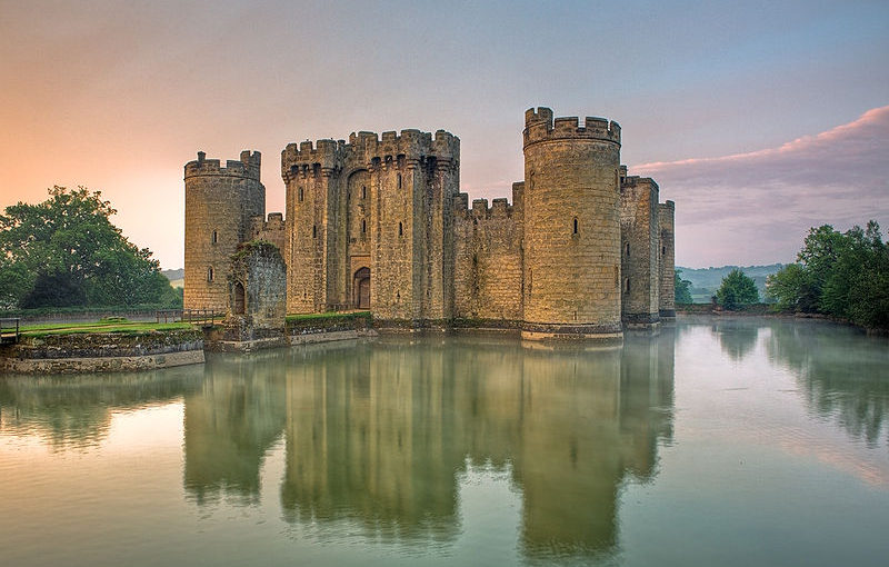
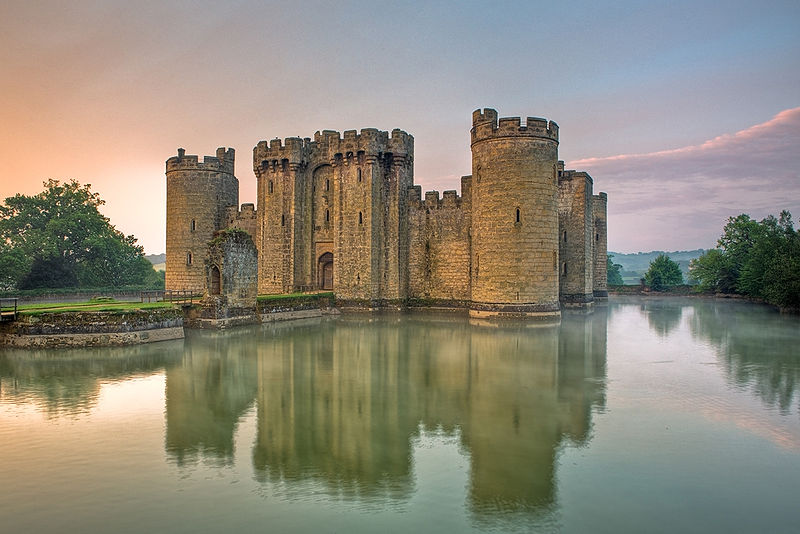
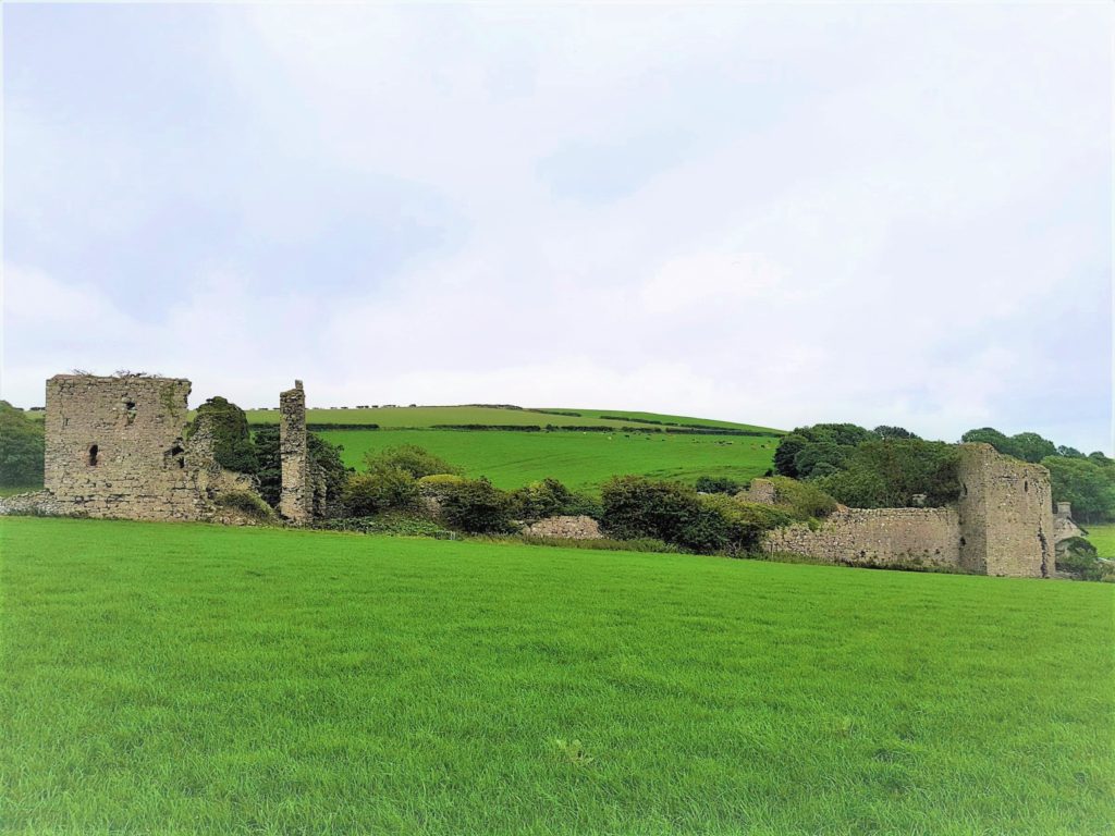
Amidst all this very expensive work, in 1385, the castle at Bodiam (Sussex) was put up for Sir Edward Dallingridge, set in a lake and pierced with gun loops and now a picture-postcard National Trust attraction. It has been the centre of a battle lasting longer even than the hundred years war. Forty years ago, the late Charles Coulson famously demolished its military pretensions by pointing out its many flaws from a defensive viewpoint. Bodiam became the peaceful retirement home for a military veteran.
Bodiam Castle courtesy of Wyrdlight.com
Sometimes you only see what you want to see. Actually, Dallingridge wasn’t retired: he was commissioned to review the defences of the coast, for the king, and was actually wounded in a French attack. His gun loops may not have worked very well and his lake could have been drained – but a French raiding party was unlikely to hang around long enough to find out. In the context, the most that can be said is: we don’t know what he intended.
England swiftly lost its leading position in the race to build fortifications adapted for and against artillery as it became significantly more powerful during the course of the next century, a time when the gap between what princes and their subjects could afford expanded greatly. But many nobles did make provision for guns, and kings still put comfort first (Edward III’s work at Windsor). Between the two extremes of fortresses with evident military purpose and castles designed as palatial homes, others tried to provide for both functions, with numerous examples across the continent.
Perhaps that was what the medieval castle had always been?
Dr Rowena Banerjea, University of Reading, UK, with funding from a British Academy/Leverhulme Small Research Grant talks about the research project she works on All Along the Watchtowers! https://research.reading.ac.uk/castle-geoarchaeology-heritage/
The buried or below-ground archaeology at castle sites can be exceptionally well preserved because of its burial under masonry. However, it is often overlooked in conservation and management plans in favour of protection and consolidation of standing remains and developments such as reconstruction and rebuilding projects. It provides an important lens through which we can examine important phases and hiatuses in the developmental history of these monuments.
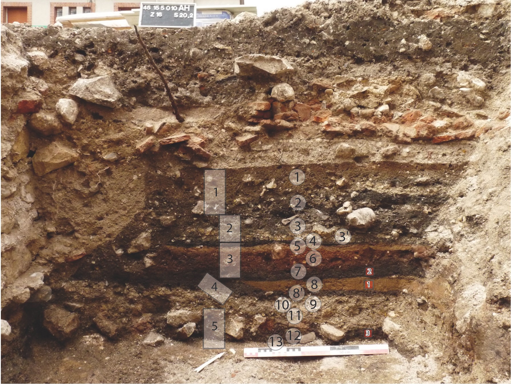
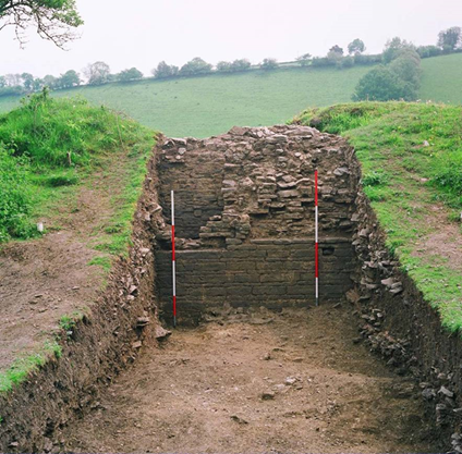
INSERT FIGURE 1. Well-preserved stratigraphy at Château de Gien, France, from c. 9th – 11th AD occupation, sealed below later masonry and collapse.The rectangles show where micromorphology samples were collected, and the circles mark the locations of spot samples for other scientific analyses. Photo credit Quentin Borderie.]
This project has been made possible due to its project partners and collaborations with several other research projects. The castle case studies represent a diverse range of cultural, environmental and heritage contexts across Europe, in which we could examine the preservation of stratigraphy, biological remains, artefacts and materials:
Castle Keverberg (Kessel), the Netherlands, which consisted of an original stone tower built in 1100 and covered by a motte-and-bailey castle;
Several French castles, which are Château de Caen, built in 1060, Château de Gien, which today hosts the National Museum of Hunting with the remains of an early (c. 9th – 11th AD) Carolingian castra below, Château de Loches and Château de Boves;
Two Italian case studies, Castelseprio, a UNESCO World Heritage site, and Montegrotto;
Dunyvaig Castle, Islay, Scotland, formerly the naval fortress of the Lords of the Isles, the chiefs of the Clan MacDonald.
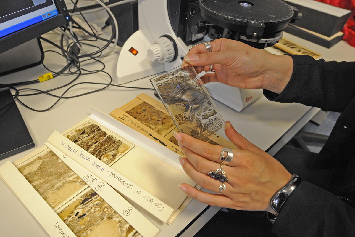
This project developed a framework for geoarchaeological research at European castles to target archaeologists, castle curators and heritage management policy-makers, so that our guidance can influence their future excavation strategies and conservation plans. Geoarchaeology applies environmental science techniques to archaeological research questions. Soil micromorphology is a geoarchaeological technique that enables us to conduct a micro-excavation by analysing a slide, or ‘thin section’, produced from an intact, small block collected from the archaeological stratigraphy, so the inclusions are still in situ. The slide is analysed using a geological polarising microscope. Under the microscope, we record the same soil properties as archaeologists do in the field and additional ones, to understand the processes by which materials were deposited, how they have decayed due to chemical weathering, and how later human and faunal disturbances have affected the stratigraphy.
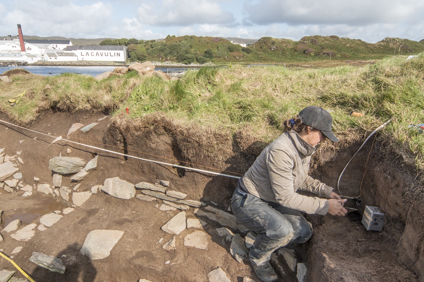
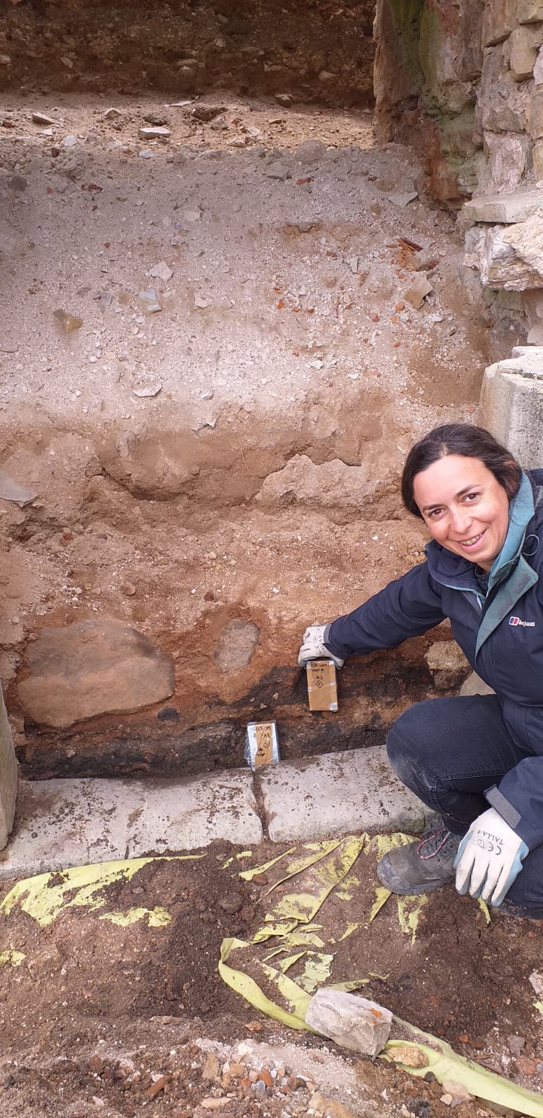
FIGURE 2. Micromorphology sampling of turf modifications to the curtain wall at Dunyvaig Castle, Islay, Scotland. Photo credit The Dunyvaig ProjectFIGURE 3. Micromorphology sampling of occupation deposits sealed below later masonry and collapse during excavations ahead of conservation work on the eastern range of Cēsis Castle, Latvia. Photo credit Alex BrownFIGURE 4. Micromorphologyor ‘thin sections’ from Elbląg (Poland) and Karksi (Estonia) castles. Photo credit Magnus Elandner
Soils and sediments are the backbone of the archaeological record. Our data revealed important stories within the soils about the early development of castle sites, the activities that took place inside different areas of the castle and how they may relate to the activities in a castle’s hinterland. We noticed that the preservation of the stratigraphy was exceptional owing to its burial under later masonry structures, masonry collapse and successive occupation layers; a phenomenon which is also observed on urban sites and Near Eastern tell sites.
Our results highlight the great potential and requirement for scientific analysis of these deposits when they are uncovered by excavation and/or building activities. These building activities include the conservation and renovation of the standing architecture and the removal of rubble, which can unseal buried archaeology affecting its preservation. Our analyses have revealed microscopic evidence for in situ animal husbandry and horse stabling, as well as the types of fodder that livestock were fed, crop processing activities, and periods of soil formation where areas of a castle have been abandoned or changed use. For example, at Castillo de Molina de Aragón, Spain, microstratigraphic data show the changing nature of the occupation the citadel, from the Islamic to Christian period which could possibly indicate a change in its role from a clean, well-maintained space to one where livestock roamed. The Islamic plaster floor surface was kept clean and very little domestic refuse accumulated ̶ a soil formed over it, followed by a substantial destruction horizon. In comparison, units of discarded material and trampled floor surfaces characterise the (Re)Conquest phase, c. 1154, and a series of plaster floor surfaces with associated occupation residues containing herbivore dung showing that livestock were present, which probably relate to modifications during the thirteenth and fourteenth centuries.
Hello! A personal introduction before we get down to the geophysics. I’m Kayt Armstrong, and I am an advisor to the Castle Studies Trust as a specialist in the use of geophysics in archaeology. I am also a member of the board of the International Society for Archaeological Prospection, and I represent the UK on a European research network about soils and geophysics in archaeology. I obtained my PhD in Archaeological Geophysics from Bournemouth University in 2010. I have worked in the UK and Europe (Greece and Italy) since that time, conducting archaeological geophysics in a variety of research and developer-led contexts. I help the CST evaluate funding applications that have geophysical elements, and also comment on the reports from any resulting work.
If you were a Time Team enthusiast, you probably already know the answer to this one!
Geophysics is the study of the physical properties of the earth (or other planets – you can do astrogeophysics!). It is an extensive term that encompasses whole planets, right down to understanding the microstructures of stone. Archaeological geophysics falls into ‘near-surface geophysics’, which studies the first 30m or so of the ground. In fact, commonly, archaeological geophysics is only really concerned with the top 2m or so; material in the topsoil, rather than the bedrock.
Geophysicists use a variety of methods and instruments to get information about the physical properties of the ground, such as its ability to conduct electricity, or its magnetic properties. Small variations in those properties can then be mapped. Buried archaeological material causes variations in the properties in predictable ways. This means we can map buried archaeology using these methods, without having to dig everything up.
When it comes to Castles, there are three main geophysical methods: earth resistance (‘resistivity’), magnetometry, and ground-penetrating radar (GPR). All three techniques look at slightly different aspects of the sub-surface, and all three have benefits and weaknesses. It is really best to combine methods to get as complete a picture as possible, as they will all tell you slightly different things.
Magnetometry
Magnetometry is probably the most commonly used technique in archaeology. It uses sensors to look at small variations in the strength of the earth’s magnetic field, to look for changes caused by buried material. The soil on sites where humans live becomes more magnetic over time, due to things like fires for cooking and warmth and the fermentation of waste material. This material becomes the fills of cut features like pits and ditches. These end up more magnetic than the soil they are cut into.
Structures used for processes involving heating, such as kilns, furnaces and ovens, become even more strongly magnetised and have a very characteristic appearance in the data. Similarly, fired ceramic building materials like brick or tile have a distinctive signal, as do igneous or metamorphic rocks (those modified by heating during their formation).
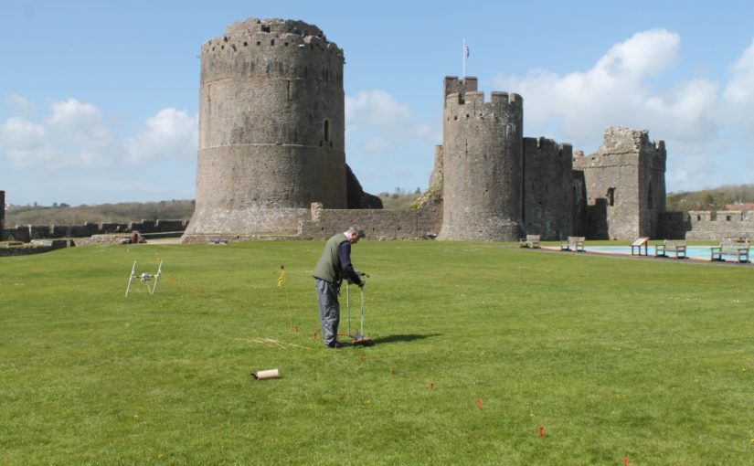
Magnetometry survey of Pembroke, funded by the CST in 2016
Magnetometry is very fast, covering upwards of 10ha a day if using the latest equipment. It is also relatively easy for community groups to employ. However, the pace will be somewhat slower using hand-carried single sensors. The plus-sides are the speed of survey and the wide variety of archaeological features that can be detected and mapped. The downsides are that this method is strongly disrupted by ferrous material in the survey environment, and has problems on igneous and metamorphic geologies as happened with the survey of Tibbers in 2014. It is also not very useful for mapping stone remains that are not strongly magnetic (such as some sandstones and most limestones). Modern infrastructure within or adjacent to the survey area has a far greater impact on the results than any buried archaeology (as happened in the Wressle survey of 2019), masking it from detection. It is practically not possible to use this method in urban areas. This method cannot detect smaller structures if they are buried more than about 2m below the ground surface. Features in the first 2m can usually be detected but the size of the anomalies that can be distinguished depends on the resolution of the readings taken. However, this method doesn’t let you understand the depths of the anomalies, and so isn’t as helpful on multi-period sites.
Earth Resistance
Earth resistance examines how easy it is to pass an electrical current through the ground. The resistivity of the subsurface varies in relation to several properties. Still, the most substantial effect is caused by variations in moisture content. The fills of cut features like pits and ditches (as witnessed in the 2018 survey at Laughton which showed a possible ditch, confirmed in the 2019 excavation and of Tibbers which lead to the discovery of a new inner bailey) tend to have a more open texture than natural soil. They usually also contain more organic matter. This means they are generally wetter than the ground they are dug into. Conversely, buried structures like walls and floors, are usually much drier than the material surrounding them, because they can’t absorb as much water.
Earth Resistence Survey at Tibbers, co-funded funded by the CST in 2016. Copyright HES
This technique can be applied in two ways. You can collect a grid of readings over a flat area to examine the first 2m or so, producing a plan view. You can also collect long lines of readings with increasingly wide measurement points. This is called ‘Electrical Resistance Tomography’ or ERT, and produces vertical pseudo-sections through the ground, and can reach greater depths, typically in archaeology 8-10m.
The plan-view method typically involves 2 probes on a mobile frame, and two remote probes connected by a cable. 2 of the probes inject a current, and two measure the resistance to it. It is especially useful for mapping buried stone structures. It is therefore handy on ‘Castle’ sites where multiple building phases can be expected. It is relatively slow, however, and relies on being able to insert probes into the ground to get the readings. This is fine on a lawn or field, and it can work on paths and gravel, but the results get very noisy, and it isn’t possible over flagstones or tarmac or concrete. You also need to be able to manoeuvre the cables and place the remote probes at an appropriate distance. This method also doesn’t let you understand the relative depths of various anomalies.
ERT is less commonly used in archaeology, but it has some specific applications in the study of large defended sites. Because it can resolve structures at a greater depth than the plan-mode, it can be used to examine the construction of large structures. This includes moats, earthen banks and buried fortification walls, and other such features. If multiple adjacent profiles are collected, the data can be combined into a 3D model of the subsurface, which can help resolve questions about the construction sequence of a site.
Twin-probe (plan-view) resistivity survey is relatively straightforward to carry out. It doesn’t require as much skill on behalf of the instrument operator as magnetometry does. It is however, slow and laborious. The equipment is relatively cheap, and data processing and visualisation are relatively simple. This method is rarely used in the commercial sector these days but is an ideal research tool. Community groups have produced excellent research using this technique. The ERT method requires specialised equipment and a trained collector. The background knowledge needed to correctly process and interpret the data is also high.
Ground Penetrating Radar
GPR only made the odd appearance on Time Team, but in the last decade or so advances in computing (mostly increasing miniaturisation of components, and improvements in battery life) have led to a new generation of GPR kit that is more flexible and affordable.
GPR works a lot like sonar or the sort of radar employed by aircraft. A transmitting antenna sends out radio waves focused into the ground. These propagate downwards and are reflected by abrupt changes in the material of the subsurface. For example, when the waves leave a stone ceiling and move into the vault, some of the waves will be reflected back up. Some will continue on, to encounter the floor of the vault, and anything below it. The reflected waves are collected by a receiving antenna (usually in the same ‘box’ as the transmitter, a fixed distance apart). The strength of the returned waves, along with the time (in nanoseconds!) it takes for them to return is logged and plotted. This is a single trace.
Ground Penetrating Radar Survey at Shrewsbury Castle 2019, funded by the CST
The antenna is dragged along a line, and a series of traces are collected at a small interval (usually every 5cm or 2cm), which are combined together to make a profile. This is effectively a vertical slice through the ground. These are a bit difficult to read because the radio waves emit in a curved shape, so they actually travel in front of and behind the antenna, not just directly under it. This creates distinctive hyperbolas in the data. The depth of signal penetration and the size of the objects you can detect varies with antenna frequency. Depending on the frequency of the antenna, you can look very shallowly and resolve things that are a centimetre (or less) across. Very high-frequency antennas are used to assess the structure of concrete in civil engineering or to image different layers in mosaics and floor coverings. Lower frequency antennas cannot resolve smaller anomalies but can penetrate 10m+ to resolve much larger objects, such as former river beds, large walls or banks and ditches.
Groups of profiles collected in parallel lines can be combined together to make a 3D block of data. This can be processed in a way that allows different horizontal depth slices to be examined (as done at Fotheringhays; see time slice). A new generation of GPR system uses lots of antennas in an array to collect very high- resolution datasets (8cm in all directions), or arrays of different frequencies to quickly collect data with good resolution at multiple depths.
GPR requires a skilled operator to plan the work, collect the data and the process and analyse the results, but it is arguably the best technique for investigating Castle sites. This is because it tends to be good at detecting the sorts of things we would expect to be looking for, for example, voids, buried walls, culverts and surfaces. It can also be deployed inside standing buildings, to look underneath floors or behind walls. It can be used over tarmac and concrete (providing the concrete is not re-inforced!) and does well on most geologies, except for certain kinds of clays, and saline environments like estuaries.
The other advantage of GPR is that the data is relatively fast to collect, compared to earth resistance, and a broader range of features can be detected with it. It is also an inherently 3D method and allows complicated below-ground sequences to be visualised and interpreted. I have seen examples of staircases being visible in the data from 3D GPR, for instance. This technique has made the headlines recently, with the publication of a study of an entire Roman city, Falerii Novi, just north of Rome, by colleagues of mine from Ghent University and Cambridge University.
Geophysics and the Castle Studies Trust
Geophysical approaches form an increasing component of research proposals put to the trust, which is excellent to see! Geophysics can help to answer both broad and specific questions about castle-sites, without the potentially destructive process of excavation. Geophysics also has applications for the conservation of sites and planning for their future management. For example, in mapping the integrity of standing walls using GPR, or understanding the soils and material within earthworks to protect them from erosion in extreme weather events. They can help site managers decide whether an intervention is necessary, and can inform the design of any needed work. Geophysics can also play an essential role in the continuing life of these sites as homes or places of historical interest by mapping areas where conservation or building work is planned to ensure nothing is damaged by the work.
To help keep you entertained during this strange and hopefully unique Christmas the Castle Studies Trust has prepared a Christmas quiz. Can you name the castles these pictures are or images are taken from either our projects from all years or blog posts during the year?
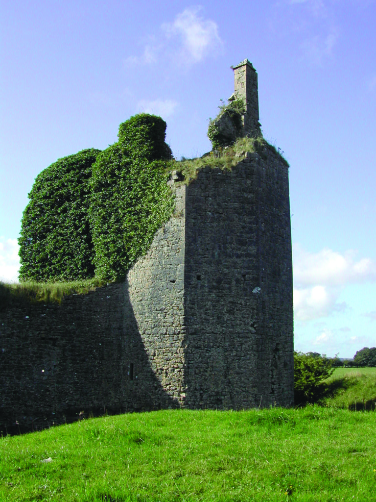
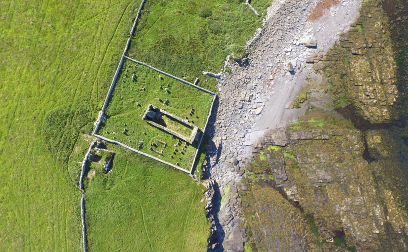
Project leads, Drs Sarah Jane Gibbon and Dan Lee reveal the results of the geophysical survey part of their project on The Wirk funded by the Castle Studies Trust.
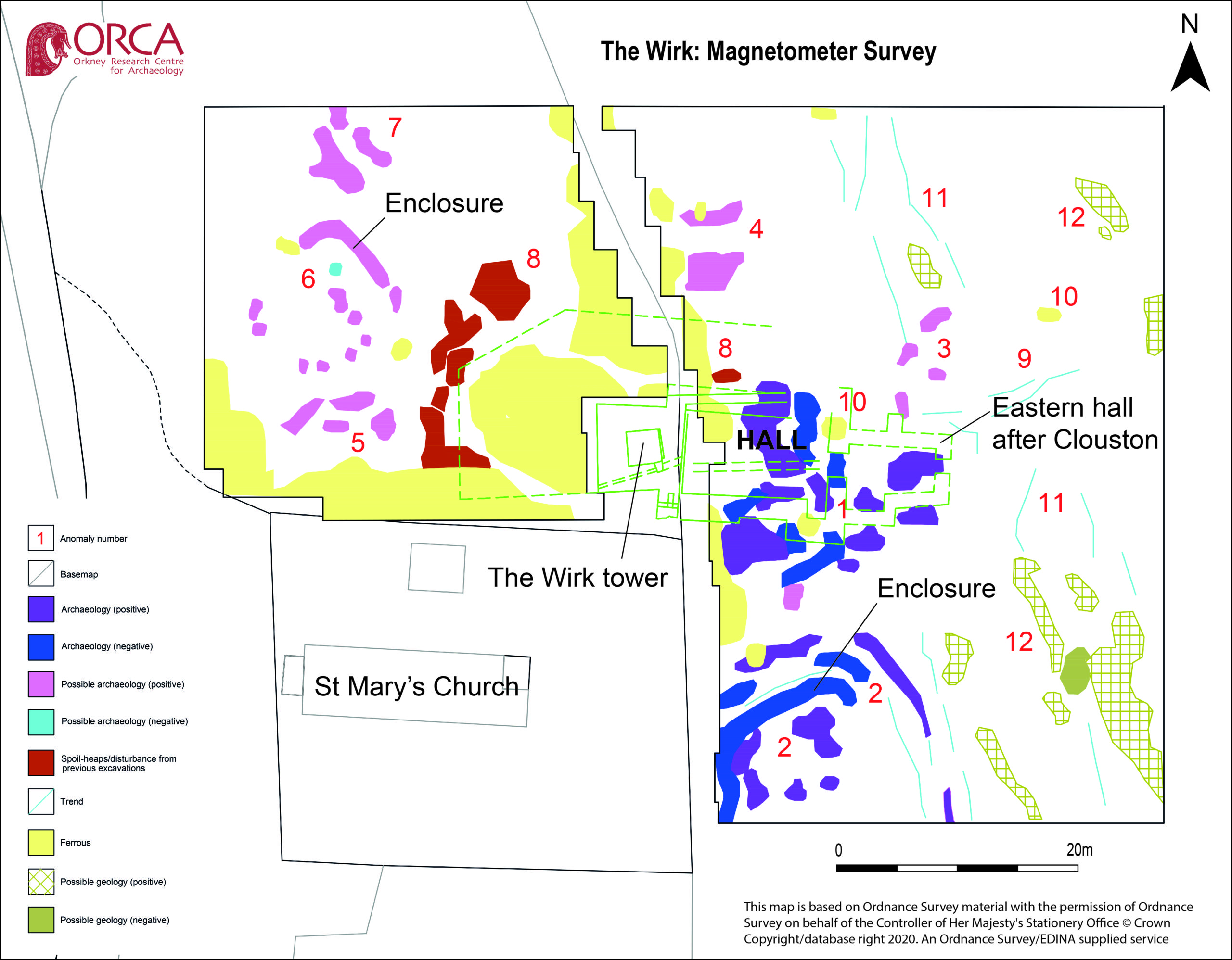
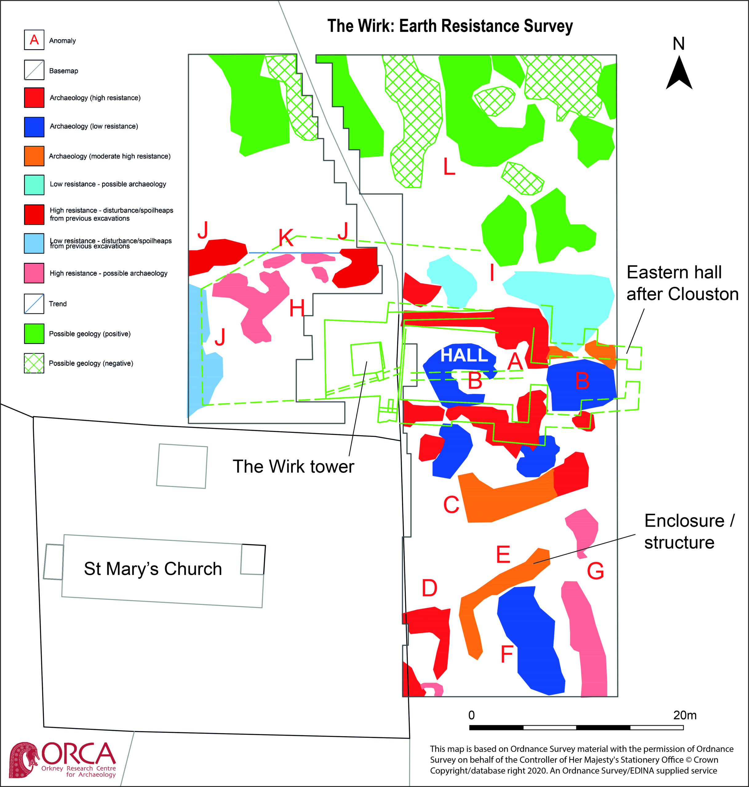
Thanks to a grant from the Castle Studies Trust, ateam from the Orkney Research Centre for Archaeology undertook geophysical survey at The Wirk, Westside, on the island of Rousay, Orkney in September, despite the challenges. Long grass was cleared from the site and a grid was established to the north, east and west of the stone-built tower. Two techniques were used: magnetometer survey (good for identifying magnetically enhanced material from burning and settlement activity) and earth resistance (good for locating walls and structures).
The aim is to better understand the nature and date of the tower which has variously been interpreted as a 12th century Norse Castle, a hall-house tower, a defensive church tower and a 16th century tower and range. Previous excavations by J. Storer Clouston in the 1920s cleared the stone tower and exposed a large range to the east, although phasing of the buildings remains unclear. The tower was left exposed but the area to the east was backfilled. A scale plan was made but recording and description of the built remains was minimal.
High-resolution magnetometer survey and targeted high-resolution earth resistance survey was undertaken across the site in order to characterise the buried structures, put the tower and hall in context and inform trench location. Clear anomalies were identified in both surveys at the site of the hall, with potential wall lines (high resistance) matching the main part of the building in Clouston’s plan to the east of the tower. This suggests that wall footings are likely to survive just below the ground surface. Other high resistance anomalies to the south of the hall could indicate the presence of additional structures. Results from the magnetometer survey showed strong positive and negative anomalies within the footprint of the hall and confirmed the presence of a possible enclosure to the south. A curvilinear positive anomaly to the north-west of the tower, beyond the apron, could indicate the presence of another small enclosure.
Overall, the geophysical survey has demonstrated that the footings of the hall survive to the east of the tower, accompanied by newly discovered enclosures with possible structural elements to the south and north-west. The extent of the site appears to extend beyond the visible remains with anomalies continuing into the kirkyard.
Dr Edward Impey, one of the UK’s leading castle experts and patron of the CST examines some C13 graffito can boost our understanding of castles.
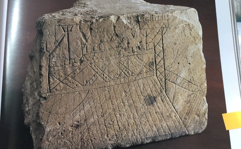
As every castle book reminds us, the defences of most castles before the mid-13th century, and the buildings within them, were built of earth and timber. The perishable nature at least of the timber parts, and their replacement in many cases in stone (obviously) makes their structural detail hard to understand, although Robert Higham and Philip Barker’s Timber Castles of 1992, and their publication of Hen Domen (Montgomery) in 2000 achieve a great deal in this direction. As most evidence is archaeological, however, it tends to be confined to plans and layout. Herein lies the importance of this graffito, scratched into a re-used ashlar in the early 13th century and found during the excavation of the long-demolished donjon in the castle at Caen in 1966: it shows, in elevation, what is unquestionably a timber-framed castle, or part of one – either a ringwork or a motte.
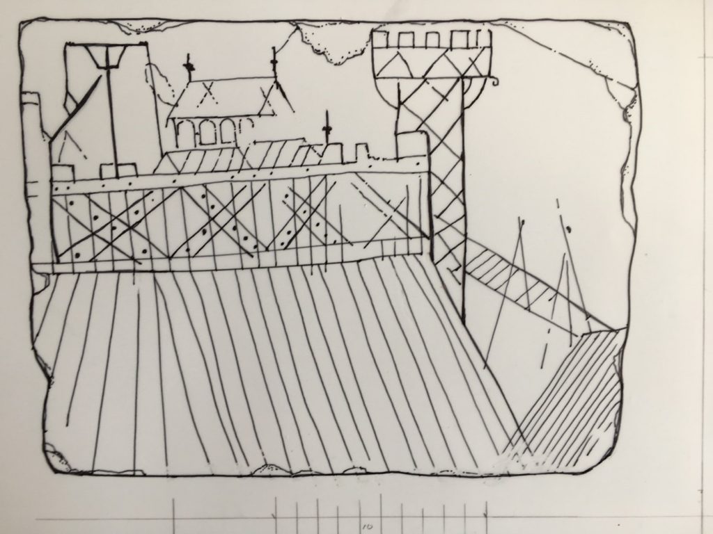
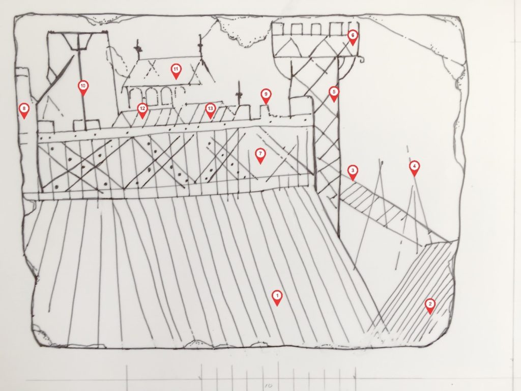
The graffito re-drawn, omitting the underlying mason’s tooling and lines probably unconnected with the original image.
To begin our description with the mound on which the buildings stand, this is marked with a series of lines inclining inwards towards the top, which may be the draughtsman’s device to give it substance, or, possibly, represent baulks of timber covering the slope – a variant of the arrangement found for example at South Mimms (Hertfordshire) and elsewhere. To the extreme right, similarly striated, is what must be the counterscarp of the ditch, and springing from it, possibly propped by two trestle-like structures, is the bridge across it: this is of the so-called ‘flying form’ shown in the Bayeux Tapestry and found archaeologically at Hen Domen. At its top end the bridge abuts a tower, necessarily a gate tower, its side scored with the diagonal intersecting lines, probably representing cross-bracing of the form found in the bell towers at St Leonard’s, Yarpole (1195-6) and St Mary’s, Pembridge, of 1207-23 (both Herefordshire); variants are known in France and over forty post-medieval examples in central Europe. The arrangement is also shown in a carving at Modena cathedral, and in numerous 12th -and 13th– century bestiary illuminations of timber towers on the backs of elephants, prompted either by Pliny the Elder’s or the Books of the Maccabees. Siege towers could be similarly constructed, hence the French term beffroi.
. The re-drawing numbered to indicate the main features described in the text. 1. Revetted earthwork slope 2.The moat counter-scarp 3.Bridge 4.Possible trestles supporting bridge 5.Gate tower 6.Oversailing platform at tower top 7.Timber wall 8.Possible second tower 9.Battlement 10.Hoist 11.Hall? 12.Second building within the enclosure Third building
Abutting the tower is the battlemented wall or palisade, composed of edge-to-edge vertical timbers, reinforced by a horizontal rail at top and bottom and by massive diagonal or ‘X’ braces, face-nailed to the uprights.
Inside the enclosure, our draughtsman has shown at least three buildings. The most prominent has a pitched roof terminating in finials, with a row of four round-headed windows under the eaves. Conceivably this was intended as a chapel, but the windows more probably belong to the clerestory of an aisled hall, as survive in the single-aisled hall of c.1160 in the castle at Creully, seventeen kilometres north of Caen, and has been inferred in the 12th-century timber examples at Leicester castle and the Bishop’s Palace at Hereford. In front are two lower buildings with pitched roofs, one carrying a finial.
To the left of the hall is a structure consisting of a vertical pole, a cross-bar at the top, propped by diagonal braces. At first sight rather puzzling, this is clearly identifiable as a crane or hoist, thanks to the dozens of near-identical examples in medieval images, conveniently gathered together by Günther Binding’s compendium of 2001. To the right of the pole hangs a rope, taut as if being pulled or winched downwards, and which is carried over the cross-bar and two faintly-indicated pulley wheels, beyond which it hangs down again and appears to be in the act of hauling a large timber into the air.
The value of the depiction can be summarised as follows. First, it may be the only contemporary representation of a timber-built motte-top or ringwork complex, and is valuable in showing the whole apparatus of palisade, battlements, bridge, gate tower and buildings within. Second, along with the Abbaye aux Dames capital, it is one of only two known representations of face-nailed ‘X’ bracing – an arrangement by definition untraceable archaeologically – which would have endowed the palisade with immense lateral strength and was perhaps widely used. Third, this may be the only contemporary representation of a Romanesque aisled hall – if that is what it is – within a castle. Fourth, as the battlemented platform at the top of the tower oversails its sides, forming a machicolation, it is one a number of images showing that such things did not derive from hourds, but were integral at least to timber towers long before appearing in stone. Fifth, while it has long been assumed that medieval defensive towers in timber were structurally akin to 12th- and 13th-century bell-towers, this is, apart from the Modena carving, the only one to actually show this to be so. Finally, although representing a well-known type, the crane certainly adds liveliness and interest to the composition.
Who the draughtsman was is, obviously, unknown. So is whether the graffito represents a real or imaginary place, although the inclusion of the crane, in use, could be taken as a hint that a particular site, where building works were under way, was indeed intended. What is clear is that it is not a picture of the castle at Caen, nor indeed of Creully, both of quite different form.
Let’s hope that this blog and the forthcoming article (in French) will encourage the identification of other wooden castles scratched in stone, and help with their interpretation and of excavated evidence in the future.
Featured image: The graffito (reproduced by kind permission of the Musée de Normandie, Caen)
To find out more about the working being done at Caen you can visit her: https://caen.fr/actualite/un-parc-paysager-la-conquete-du-chateau
Bibliography
M. Baylé, La Trinité de Caen: sa place dans l’histoire de l’Architecture et du plate et du Décor Romans (Paris, 1979),
A.R. Boucher and R.K. Morriss, ‘The Bell Tower of St Mary’s Church, Pembridge, Herefordshire’, Vernacular Architecture, vol. 42, issue 1, pp.23-35
G. Binding, ed., Der Mittelalterliche Baubetrieb in zeitgenössischen Abbildungen, (Darmstadt, 2001), available in translation as Medieval building techniques, (Stroud, 2004).
M. De Boüard, Le Château de Caen (Caen, 1979)
R. Higham and P. Barker, Timber Castles (London,1992)
R.Higham and P.Barker, Hen Domen, Montgomery – A Timber Castle on the English Welsh Border (Exeter, 2000),
Karel Kuča & Jiří Langer, Dřevěné kostely a zvonice v Evropě (Timber Churches and Bell Towers in Europe), 2 vols.(Prague 2009)
N. Molyneux, ‘The detached bell tower, St Leonard’s Parish Church, Yarpole, Herefordshire, Vernacular Architecture, vol. 34 (2003), issue 1, pp.68-72
Bill Klemperer is the Principal Inspector of Ancient Monuments for Historic England – advising on aspects of national policy and casework around the country – especially the midlands where he is based in the Birmingham office. Here he talks about four important border fortresses he has helped save.
Altogether there are many hundreds of castles in the Welsh borders most of which are scheduled – protected by law under the 1979 ‘Ancient Monuments and Archaeological Areas Act, 1979’ and part of my job is to help look after them. One of my predecessors, the late Anthony Stretten, undertook a survey in the 1990s to identify those castles that would require most effort to save them for the future. A ‘top four’ emerged – all with significant stone buildings that required repairs – Wigmore Castle just west of the village in north Herefordshire, Hopton Castle in south Shropshire west of Leintwardine, Wilton castle on the River Wye at Ross-on-Wye, and Clifford castle further up the Wye just north of Hay-on-Wye. They have now all been repaired – but the solutions have been different in each case.
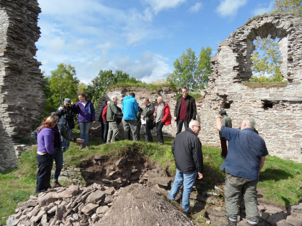
Wigmore. This was a case of state intervention. Following a collapse the then Secretary of State, Peter Walker, agreed to take the castle into public ownership – so it is now maintained by English Heritage as a free visitor destination. The ruinous state of the castle was an issue – with multi-phase buildings all higgledly-piggledy all over the place. Twenty years of careful excavation was going to cost too much and would have destroyed much of the later evidence in revealing the earlier phases. So a different approach was agreed – the walls would be consolidated as they were – and the site would retain its importance for flora and fauna – a stabilised place of wonder to be discovered and explored. This became the type site for ‘soft capping’ that now has become mainstream practice. The grass on the wall tops protects the walls from the weather and after twenty years is still doing a good job. Some limited archaeology was done to inform stabilising works,but these few trenches produced amazing findings – so do get the report to find out more
Wigmore Castle Excavation
Hopton castle. An impressive earthwork site with motte and bailey and later gardens and associated buildings are evident, and also the site of a nasty civil war massacre and siege. When I first saw it I was struck that the impressive tower of c.1300 that dominates the site could be abandoned in a field without access. A condition report revealed that the north west corner was about to fall off – but how to get the money to fix it? We talked to the locals and the Hopton Castle Preservation Trust was born. English Heritage funded a condition survey and work to prepare a lottery bid and the committee decided – by the Chair’s casting vote – to award about a million pounds! Archaeological ‘clearance’ followed and CBS Conservation came in to do the works. The Duke of Gloucester helicoptered in for the official opening. The site now has free access every day of the year and is secure for the future.
Hopton Castle Restoration – mini railway to clear rubble
Wilton Castle was done at about the same time as Hopton in the first decade of the millennium. Here the ‘White Knight’ solution came to the fore in the shape of owners Alan and Sue Parslow. Wilton is a multi-phase stone castle and much work was needed to repair the walls and towers. This was jointly funded by the Parslows and English Heritage. Various different conservation techniques were used – full roofs were put back on the north west and south west towers – the former complete with chimney found in the excavation of the basement! A ‘hidden’ lightweight modern roof put onto a large 13thC east tower. Gracile [DO YOU MEAN GRACEFUL?] walls were supported by buttresses in contrasting material, wall walks discovered and replaced, a section of curtain wall rebuilt, and decayed stone, including some lintels and cills replaced. The site is now safe and the owners have open days each year.
Wilton Castle Reconstruction Work
Clifford was the most recently repaired – and this came about when the site came into the new ownership of Keith and Ann Hill, who are also keen to care for the castle in their care. Historic England (as we became in 2015) gave a grant to help the owners repair the buildings on top of the motte and this was done by Treasures of Ludlow – a well-known firm of conservation builders. Archaeological interpretation of the buildings has been undertaken by Nigel Baker while the Castle Studies Trust funded a geophysical survey and excavations there too. Amongst the tightly packed stone buildings on the large flat-topped motte is the so-called Rosamund’s Tower. Rosamund Clifford – the ‘Rose of the World’ – was brought up at Clifford Castle, daughter of the Marcher Lord Walter de Clifford. She became the mistress of Henry II and died, still not 30 in 1176. The site with its large bailey containing remains of an interesting barbican can be visited by appointment with the owners.
Clifford Castle CST Excavation Study Day – chamber block on the mott
Much work has been done and much more remains to be done. The ‘local Trust model’ is achieving spectacular results at Snodhill castle near Peterchurch in Herefordshire’s Golden valley. Another notable success in recent years has been the repair of the rare shell keep at Kilpeck castle south of Hereford. All of these places are part of our shared inheritance Looking after them is our responsibility to future generations so they can share in that wonder.
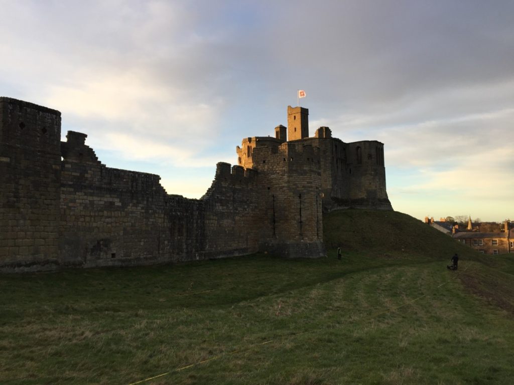
William Wyeth, Properties Historian at English Heritage Trust and project lead on the Castle Studies Trust funded project to geophysically survey Warkworth Castle explains what he hopes the survey will achieve.
In 2019 English Heritage, a charity which looks after over 400 historic properties and sites across England, began a project to change the way in which the stories of the people and buildings at Warkworth Castle in Northumberland were told. The castle is a popular destination in the county, and is both connected with notorious figures from the past as well as featuring an iconic piece of medieval architecture and design in its late 14th-century Great Tower.
Figure 1. Warkworth Castle from the south-east. The Great Tower, in the background, sits atop a large motte. In the foreground, the curtain wall is punctuated by the Grey Mare’s Tail tower. Archaeologists from Archaeological Services – Durham University are surveying the unenclosed strip of bailey
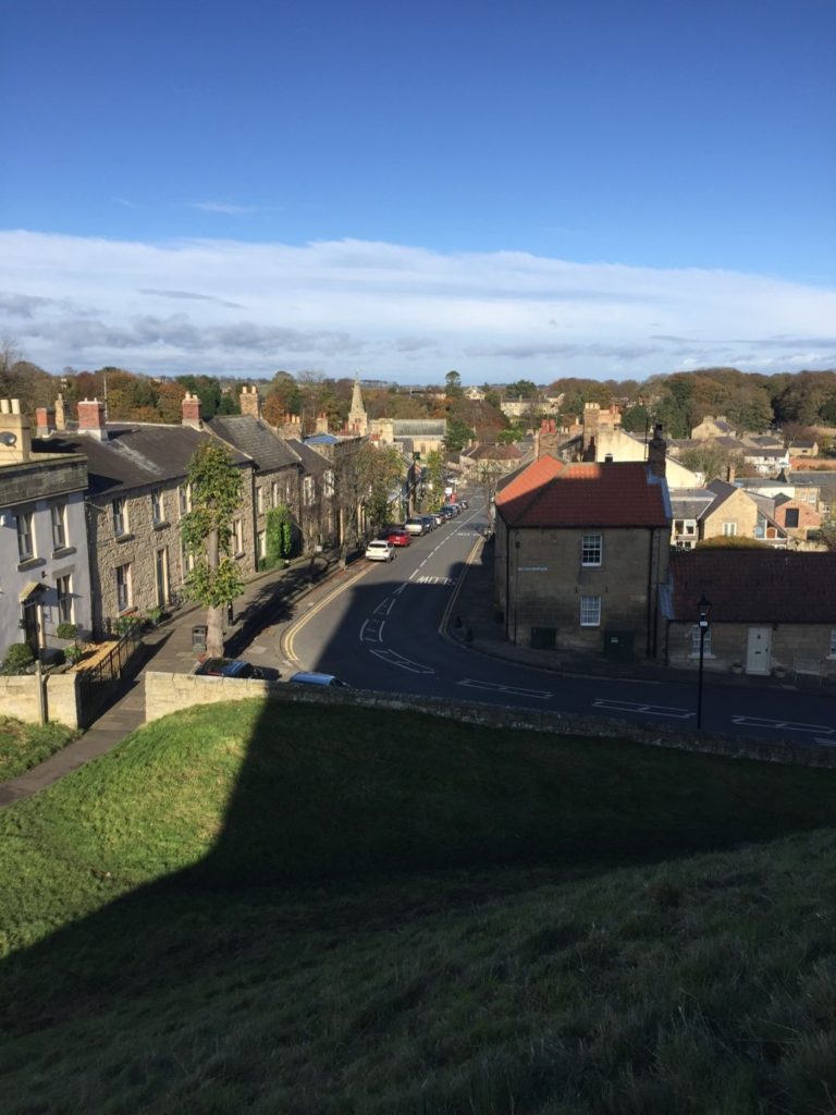
Warkworth is located at the foot of a narrow loop in the River Coquet, in coastal north-eastern Northumberland, about 25 miles north of Newcastle-Upon-Tyne and 30 miles south of Berwick-Upon-Tweed, themselves both significant fixtures of the late medieval history of this area. Just north of the castle proper and nestled on three sides within the river loop is the small village of Warkworth, arrayed in quite typical medieval layout. At the north end of the high street, sitting on a rough north-south axis, is the parish church of St Lawrence, probably an early medieval foundation, as well as a bridge with a toll-collecting tower built in the later 14th century. South of the church, numerous narrow parallel plots of land spread out at right angles from the high street. The southern trajectory of the street is abruptly broken by the enormous motte (earthen mound) of the castle, which acts to physically separate the village from the land south of the river.
Among the most famous historical figures connected to the castle was Henry Percy, eldest son of the 1st Earl of Northumberland, though he is more familiar to us today as Harry Hotspur. The origin of his martial nickname is not certain, but is accounted for in several traditions, all of which confirm that they drew from his short-tempered and violent character. One later 16th-century source rhythmically noted “For his sharp quickness and speediness at need / Henry Hotspur he was called in very deed.”
Though the early history of the Percy Northumberland earls and associated figures will form a key part of the story of the castle when the interpretation project is completed in 2022, other questions about the castle, and especially its earlier history, remain as yet unresolved. Among these is the relationship of the earthworks – the motte and bailey – with the stone structures atop them, the oldest of which date to the later 12th century. The Castle Studies Trust has graciously agreed to fund a geophysical survey of much of the castle earthworks to resolve three big questions.
The first touches upon the motte, which features the Great Tower of the 1370s, but was probably topped by an earlier structure. By assessing buried deposits around the tower, we aim to reveal traces of this earlier structure. But we also want to establish evidence for the means by which the Great Tower may have been provisioned, via a secure door to the motte-top outside the enclosing curtain wall which gave access to storage areas for beer and food in the tower’s north-west segment.
The second question relates to the bailey. In common with other castles of this type, the bailey was filled with buildings, often (as at Warkworth) in their earliest phases arrayed along the inner face of the enclosing wall. But were there buildings here before, or were there also buildings here from later periods, but for which above-ground evidence has been lost? Findings from the survey here will greatly influence how we understand the formal approach to the bailey’s principal buildings – its Gatehouse, Great Hall and Chapel – but also the late medieval Great Tower. The results may also shed light on the peculiar overhauling of spatial arrangements in the bailey occasioned by the construction of a 15th-century Collegiate Church which straddled the span of the bailey, arguably fundamentally changing how the castle was to be experienced.
The last question also relates to the bailey, but here to a strip of the bailey which sits outside the embrace of the late 12th-early 13th-century stone curtain wall, on the eastern side of the castle. The omission of this area from enclosure is unusual, though it is not without analogies from elsewhere, which suggest areas like this could contain gardens. It may be instructive that just within the bailey and adjacent to this strip was the location of late medieval stables – perhaps this area came to be used for the grazing of horses, though whether this was its original intended purpose remains to be seen. In addition to all of this, however, is the possibility that when the motte-and-bailey was built, perhaps well before the earliest stone parts of the castle were erected, the earliest enclosing wall of the bailey also embraced this eastern strip, thereby creating a larger bailey than the present one.
We hope that the survey will allow us to answer at least some of these questions. Whatever the outcome, it is certain that the results will help change how we understand the story of Warkworth Castle and its previous inhabitants.
Heidi Richards, doctoral research at Durham University, looks at Pendragon Castle and how medieval romance literature impacted later medieval castle building.
Since childhood, I’ve been fascinated by castle ruins, stories of King Arthur, and a golden age of chivalry that existed somewhere back in time between history and fantasy. Fast-forward twenty years, and I’m currently finishing my doctoral thesis looking at the impacts medieval romance literature had on late medieval English castles.
Former arguments in castle studies subjected castles into a martial vs. status dichotomy, but current research embraces the duality of these aspects of the castle, providing space to explore possible symbolisms built into castle architecture and wider landscapes.
My research explores the importance of romance literature and legend within medieval society’s most elite, and through wills, commissions, dedications, and gifts, we find that romances were highly valued. Of primary importance though, was Geoffrey of Monmouth’s (c.1138) Historia Regum Britanniae (History of the Kings of Britain). While not technically a romance, this work brought legendary heroes into an ancestral pseudo-history of the kings of Britain (including Constantine and King Arthur) and provided source material for romance narratives and characters. Many members of the elite alluded to this highly prestigious “ancestry” to legitimize and justify power, especially within the political propaganda and ambitions of Edward I.
Edward I was indeed an Arthurian “enthusiast” (as he has been called in previous research). He hosted many “Round Table tournaments” (more theatrical than regular tournaments and usually included Arthurian role-playing) to celebrate significant events, such as his Welsh victory in 1284. He exploited his “Arthurian ancestry” in a grand ceremony at Glastonbury Abbey in 1278 to reinter Arthur and Guinevere’s bodies—essentially conducting a spectacular funeral for Arthur, during which he used “Arthurian” relics (including Arthur’s crown) to legitimize his “inherited” power. He also wrote a letter to Pope Boniface in 1301 to claim land in Scotland on the basis that it was once owned by his ancestor, Arthur. A grand feast was also held at Westminster in 1306, during which Edward I swore oaths on a swan, in typical romance style, and knighted Edward II along with 267 others.
Every effort was made to continue Edward I’s Arthurian prestige and chivalric legacy when Edward II succeeded the throne. On his deathbed, Edward I charged his closest barons with assisting Edward II as his reign began; one of whom was Robert Clifford, who organized an enormous, chivalric celebration for Edward II’s coronation in 1308.
Edward II soon began to show that he was not the chivalric king his father was, staunchly contradicting the values of Edward I’s chivalric legacy. Records claim that he enjoyed working in the garden (which was uncustomary and inappropriate for a king), he didn’t like hunting, he didn’t participate in tournaments, and he thoroughly annoyed the barons with his infatuation over Piers Gaveston. As baronial unrest and tensions increased, we begin to see Arthurian allusions made by Edward II’s principal opponents—the same ones closest to Edward I.
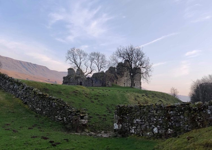
This brings us to Pendragon Castle (Cumbria, previously Westmoreland), inherited by Robert Clifford as the “castle of Mallerstang,” along with other nearby castles, including Brough, Brougham, and Appleby. Clifford renovated Brougham and Pendragon Castles in preparation to host Edward I during the Anglo-Scottish wars in 1300, but whilst his other castles were renovated in contemporary architectural styles, Pendragon retained its archaic image. Architectural archaism was a trend in castle construction, used to symbolise continuation of power and ancestral prestige. In 1309, Clifford was granted a license to crenellate, changing the “castle of Mallerstang’s” name to Pendragon Castle.
Pendragon Castle (from the moat), photo by Heidi Richards
In 1312, Guy Beauchamp, 10th Earl of Warwick, presided over the trial of Piers Gaveston, whose greatest crime, according to the commemorative Warwick ancestral “Rous Roll” (c.1484), was stealing King Arthur’s round table. The Earls of Warwick already had long-standing connections with Arthur and displayed romantic “relics” inherited from their “ancestors.” Robert Clifford and Thomas Lancaster also participated in Gaveston’s trial and execution, and in 1322, Lancaster signed a treasonous document to James Douglas in Scotland under the pseudonym “King Arthur.” In 1327 and 1328, Roger Mortimer, the lover of Edward II’s queen, Isabella, celebrated the marriages of his children by hosting multiple Arthurian themed Round Table tournaments in the style of Edward I, each lasting several days and sparing no expense.
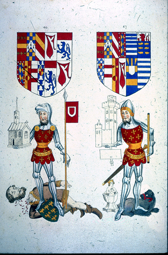
Image S-42-23 from The Heraldry Society 1845 edition of the Rous Roll, images 46 (left) showing Guy Beauchamp, 10th Earl of Warwick standing over the executed Piers Gaveston, and 47(right) shows his son, Thomas, portrayed with silver cup—heirloom relic of the fictional Swan Knight. The c.1484 original (British Library MS 48976), includes a caption below Guy’s image accusing Gaveston of selling “out of the land the round table of silver that was King Arthur’s and the trestles…” Link to Guy Beauchamp’s image in the Rous Roll (c.1484) British Library MS 48976 https://imagesonline.bl.uk/asset/143267
In the wake of Edward I’s chivalric legacy, those who were closest to him (including Clifford, Warwick, Lancaster, and Mortimer) developed ways to emulate Arthurian prestige in their opposition to Edward II, and it is within this context that Pendragon Castle comes into view as one of several homages to King Arthur, Edward I, and the not-so-distant golden age of chivalry.
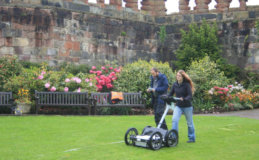
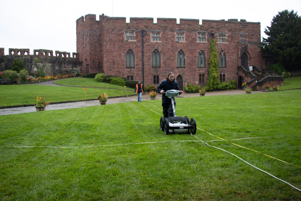
This year we’re funding investigations at Shrewsbury Castle, one of the most important castles along the Anglo-Welsh border. Nigel Baker told us how the work has been going.
Phase 1 of the Castle Studies Trust’s Shrewsbury Castle 2019 project is underway. Archaeological research is a long and painstaking process, so instant results are not to be expected – it must have taken a whole three hours to establish for the first time a number of simple but really fundamental facts about the hitherto-unexplored inner bailey.
Work started on Wednesday 8th May with the arrival at the castle of Tiger Geo, specialist geophysical survey contractors. Using ground-penetrating radar and resistivity, the lawns of the inner bailey interior and the slopes of the ramparts were gridded out and surveyed; the geophysicists never stopped, nor did the rain. But two basic conclusions emerged on screen from the raw data.
Tiger Geo doing sterling work despite the weather.
The first is that a ditch did once encircle the base of the motte within the perimeter of the inner bailey. This implies that the flat area within the inner bailey must originally have been a crescent-shaped area less than twenty metres wide from motte ditch to rampart tail.
The second conclusion is that there is, under the grass opposite and parallel to the standing early 13th-century ‘Great Hall’ (which houses a very fine Regimental Museum), another big building range backing onto the motte ditch. Given that the standing first-floor Great Hall was built as a royal chamber block (‘camera’) in the 1230s-40s, there is a possibility that a real Great Hall awaits excavation in the summer. But we’ve already answered one of the project’s main questions, ‘how was the inner bailey planned?’ The answer is there were two main ranges of buildings and no room for anything else.
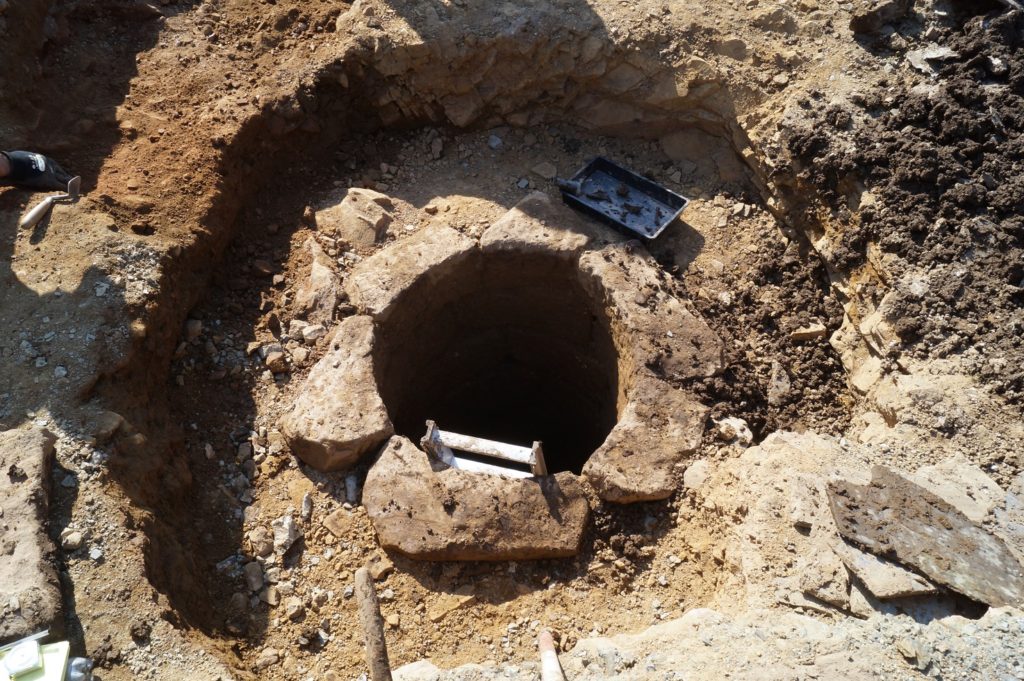
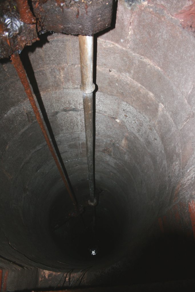
While Tiger Geo mowed the lawns, the writer was busy in a bush at the base of the motte, freeing-up a manhole cover sealed for a decade. Under, a 20th-century brick inspection chamber gives access to a stone well-shaft alongside. The writer had been shown it surreptitiously by a kind gardener in the 1990s but without the opportunity for much recording. Now it has been photographed (though not with stunning competence), measured at just over seventy feet deep from ground level down to water level, and the masonry identified as probably late medieval – and not something done by Thomas Telford in the 1790s. So – Shrewsbury Castle retains its medieval well.
The medieval well. It’s a dizzying 21m down to water level.