Berkeley Castle Donjon and Moat

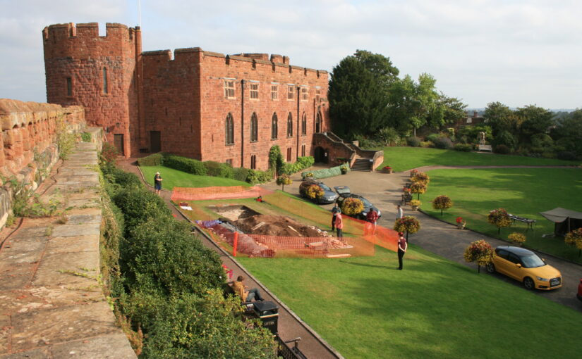
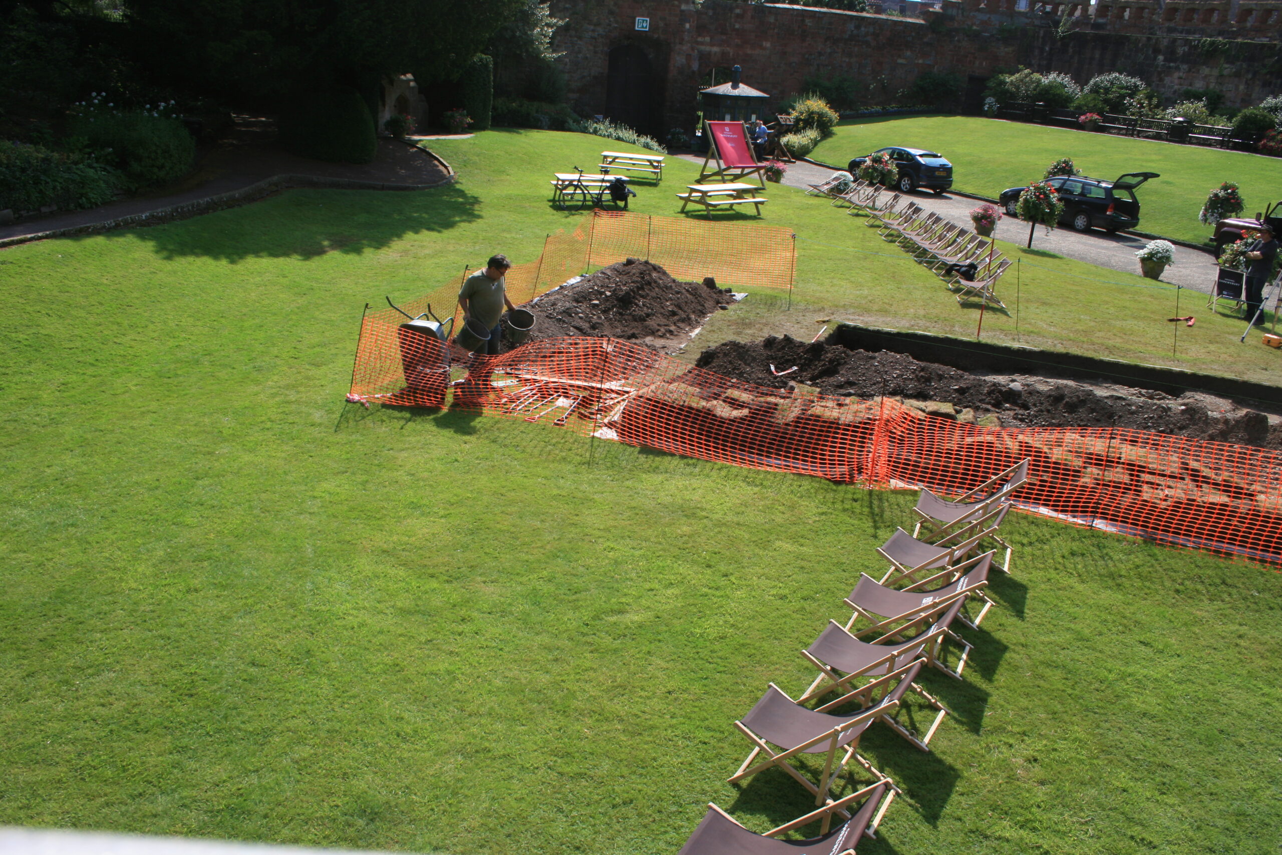
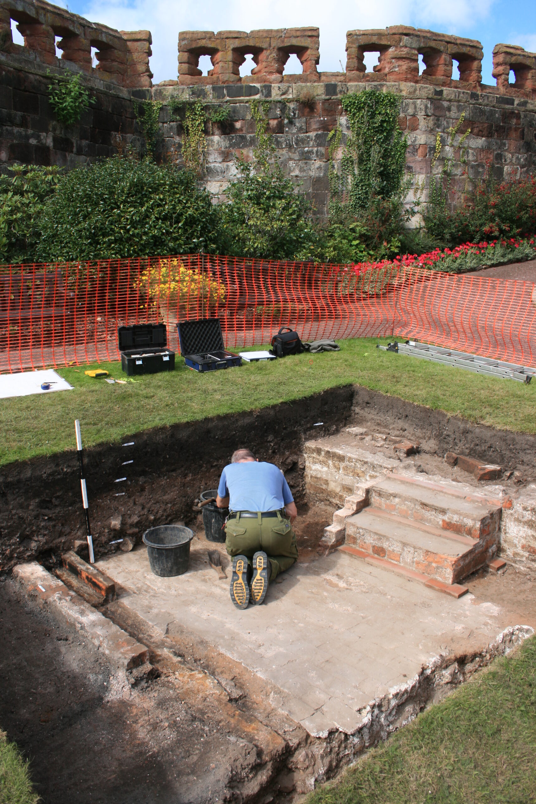
Berkeley Castle Project Excavation Director Dr Stuart Prior takes a look at one of the many interesting discoveries made during the dig which is part of a new book looking at 15 years of excavation.

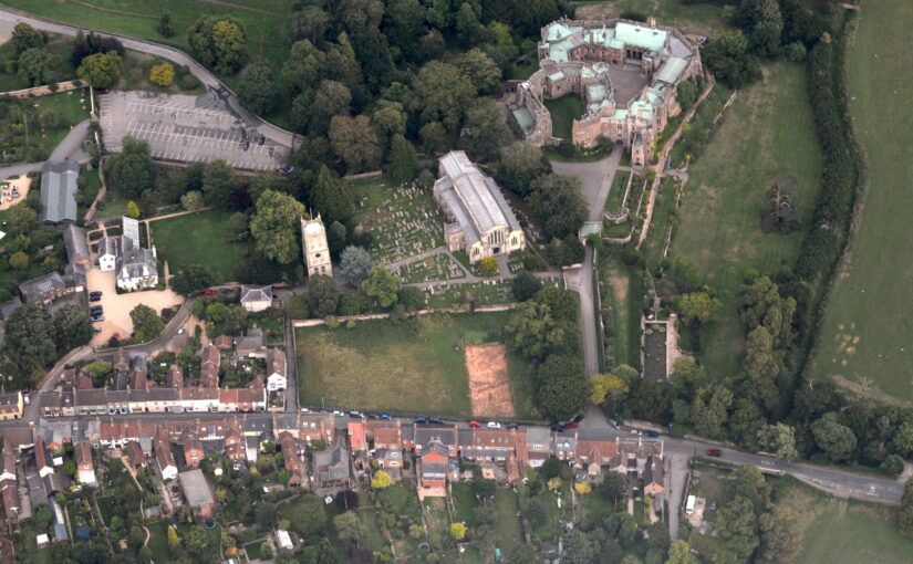
Between 2005 and 2019 the Berkeley Castle Project (BCP), conducted by University of Bristol, carried out excavations and survey work at Berkeley Castle, which have led to the publication of a new book. Excavations in 2015, of Trench 19, were able to gain insight into the early origins of the castle and the donjon that was constructed when the castle was built in stone by Robert FitzHarding in 1153–1154.

Subscribe to our quarterly newsletter

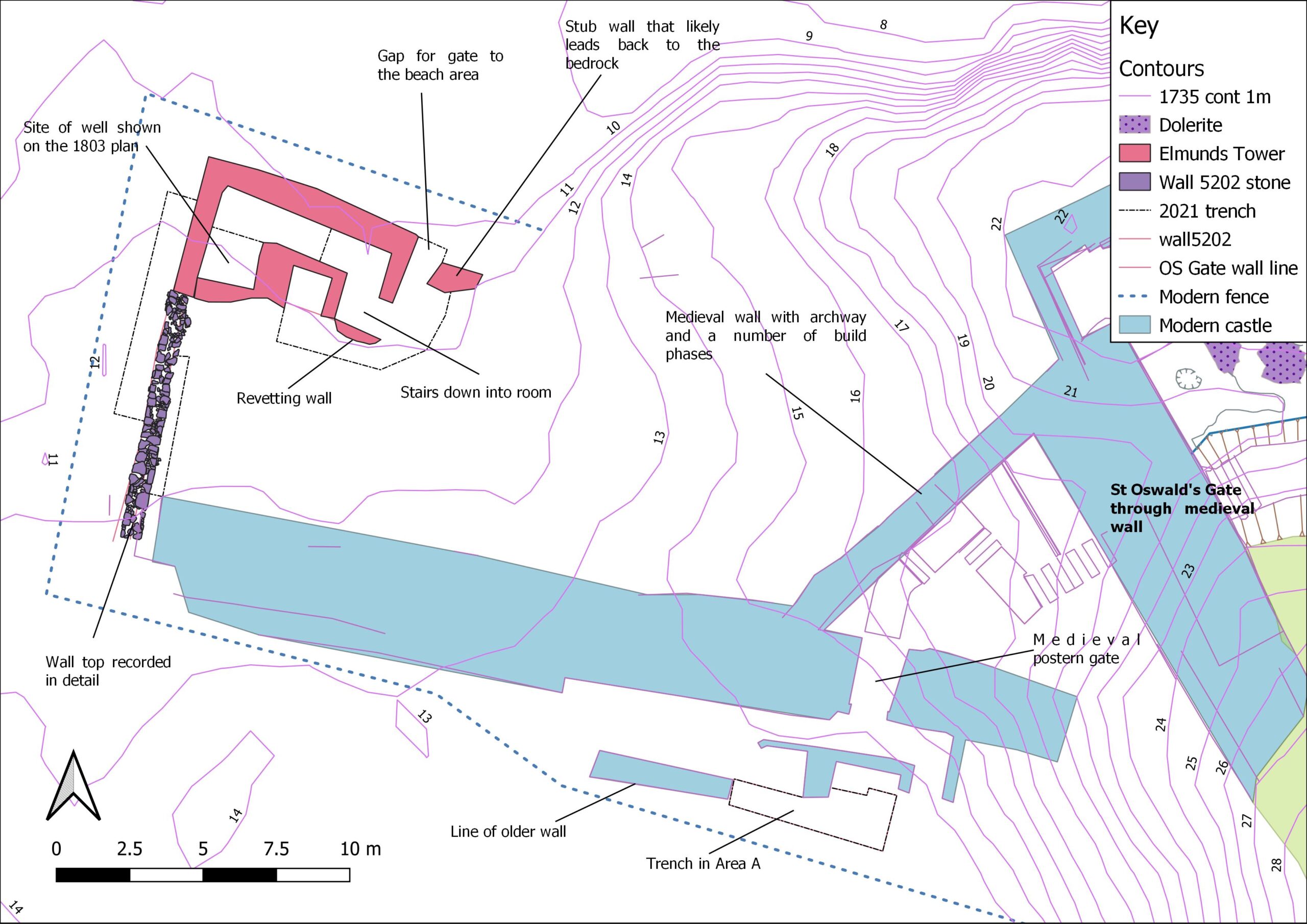
It was originally believed that the first stone castle erected at Berkeley comprised a circular shell keep, but the BCP was able to shed new light on this aspect of the site’s past and its architectural evolution. In a Castle Studies Group Bulletin (CSG Bulletin 18, 2014), Neil Guy suggested that the castle may have had a square or rectangular donjon or keep that may have been modified as the basis for the Thorpe Tower by Thomas [III] Berkeley (1292–1361). Trench 19 was designed to look for evidence of the north-west corner and west wall of this postulated donjon. The argument here was that Thorpe Tower was not wholly created ‘as new’ in the 14th century but was instead a part-relic structure arising from a 1340s re-modelling of the 12th century castle. Namely, two corners and one side of a square donjon which abutted the north side of the ‘motte’, and for which the shell-keep encasing the motte was an inner (and elevated or upper) bailey.

Figure 1: Plan view of Trench 19 showing heavily robbed-out building foundations copyright Berkeley Castle Project

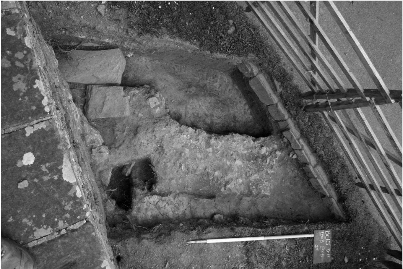
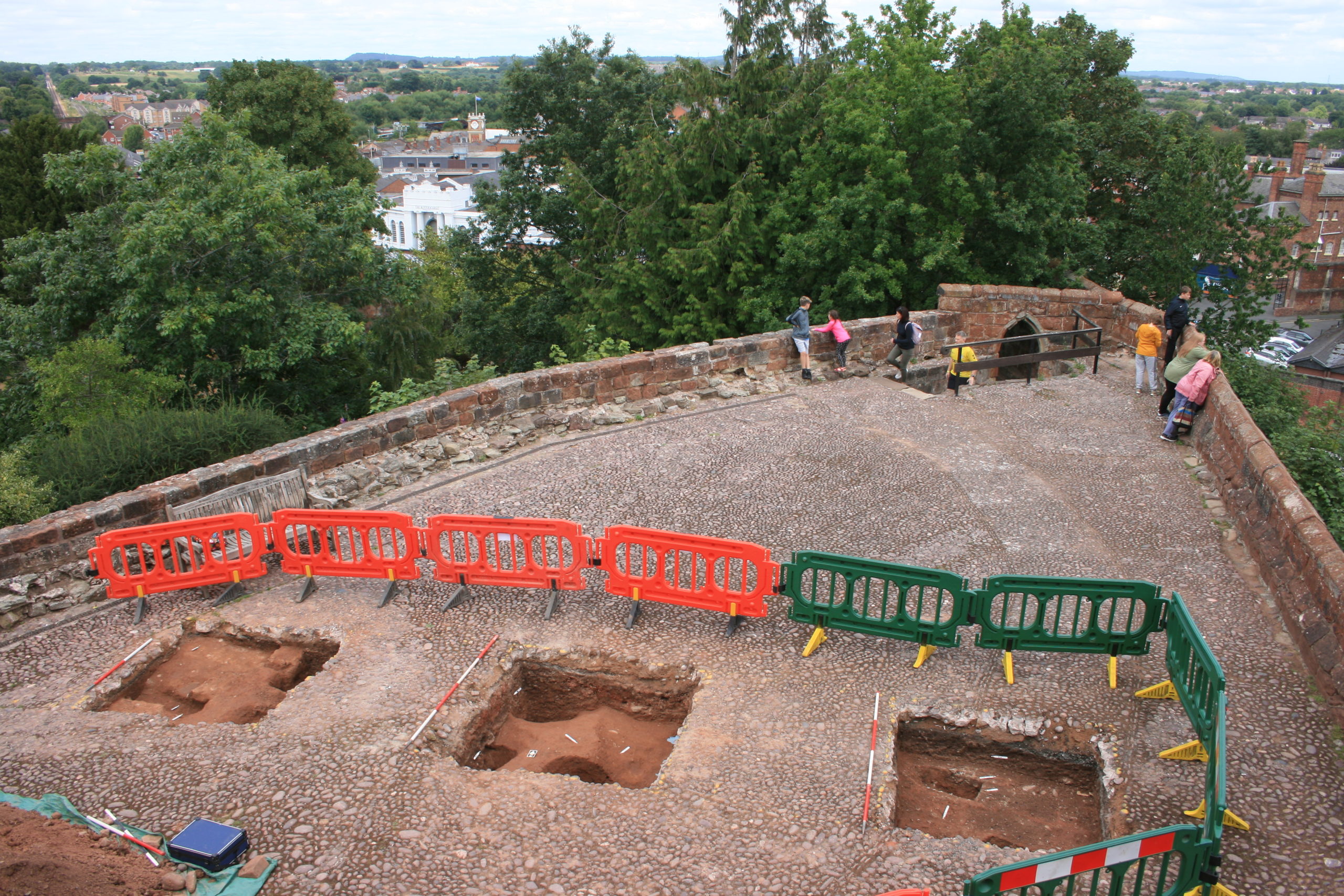
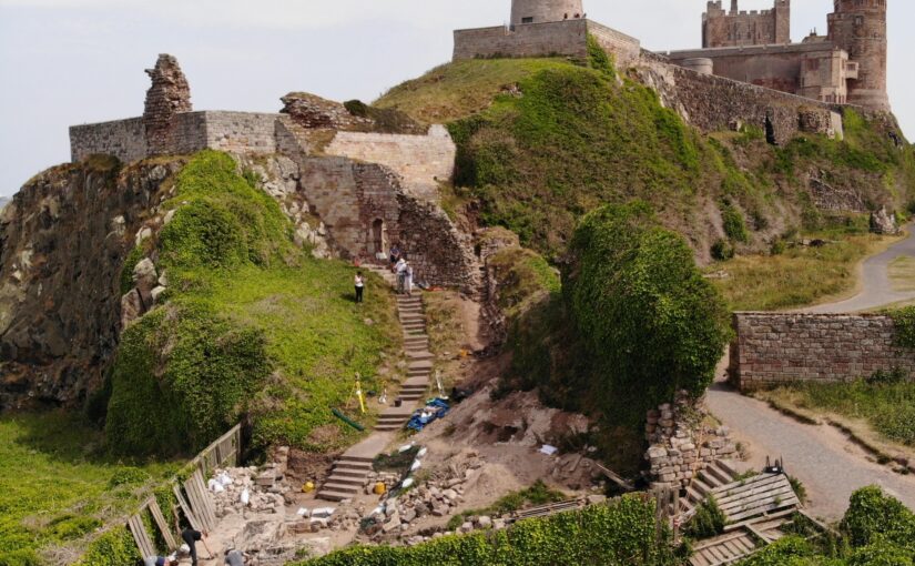
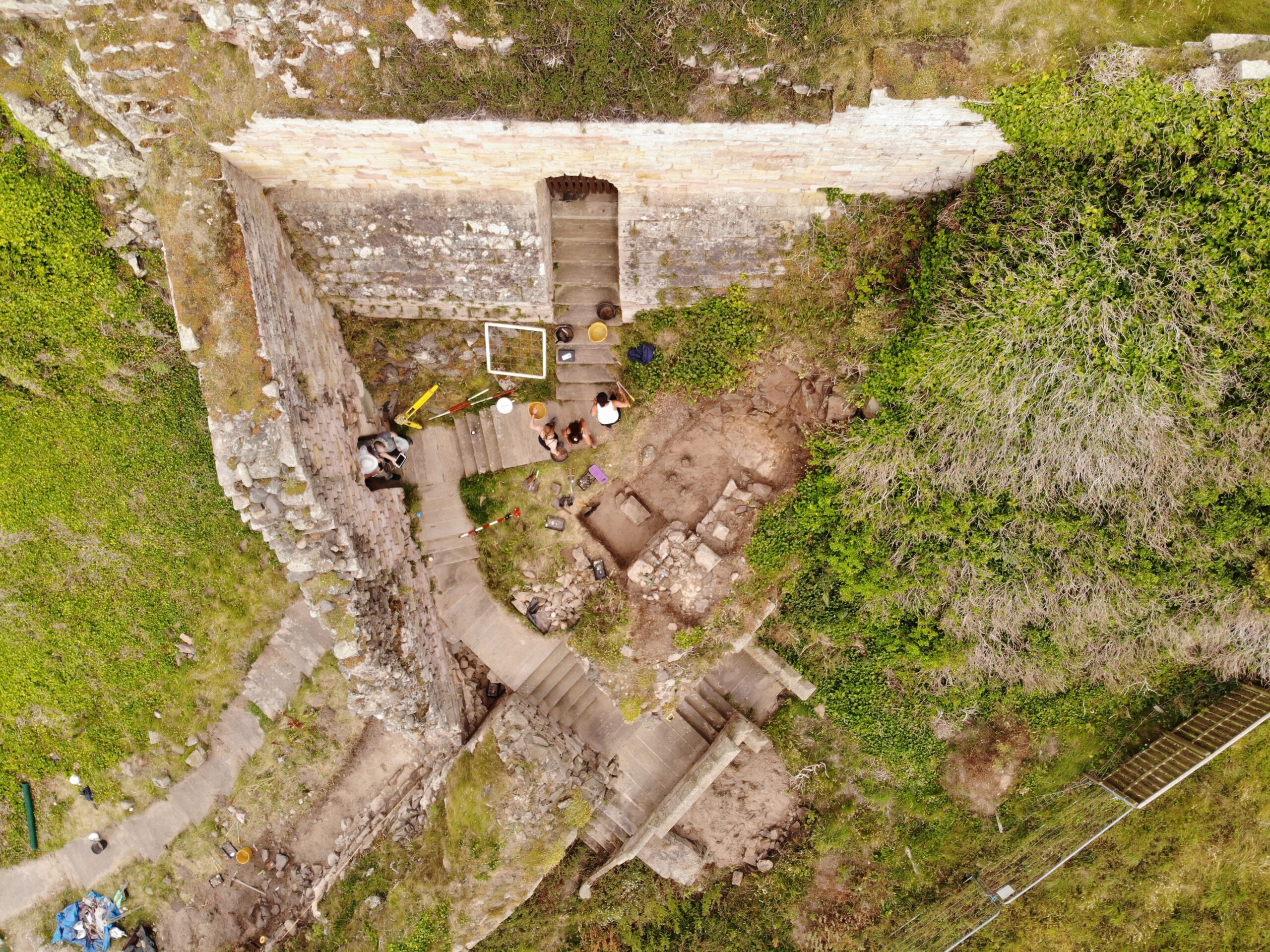
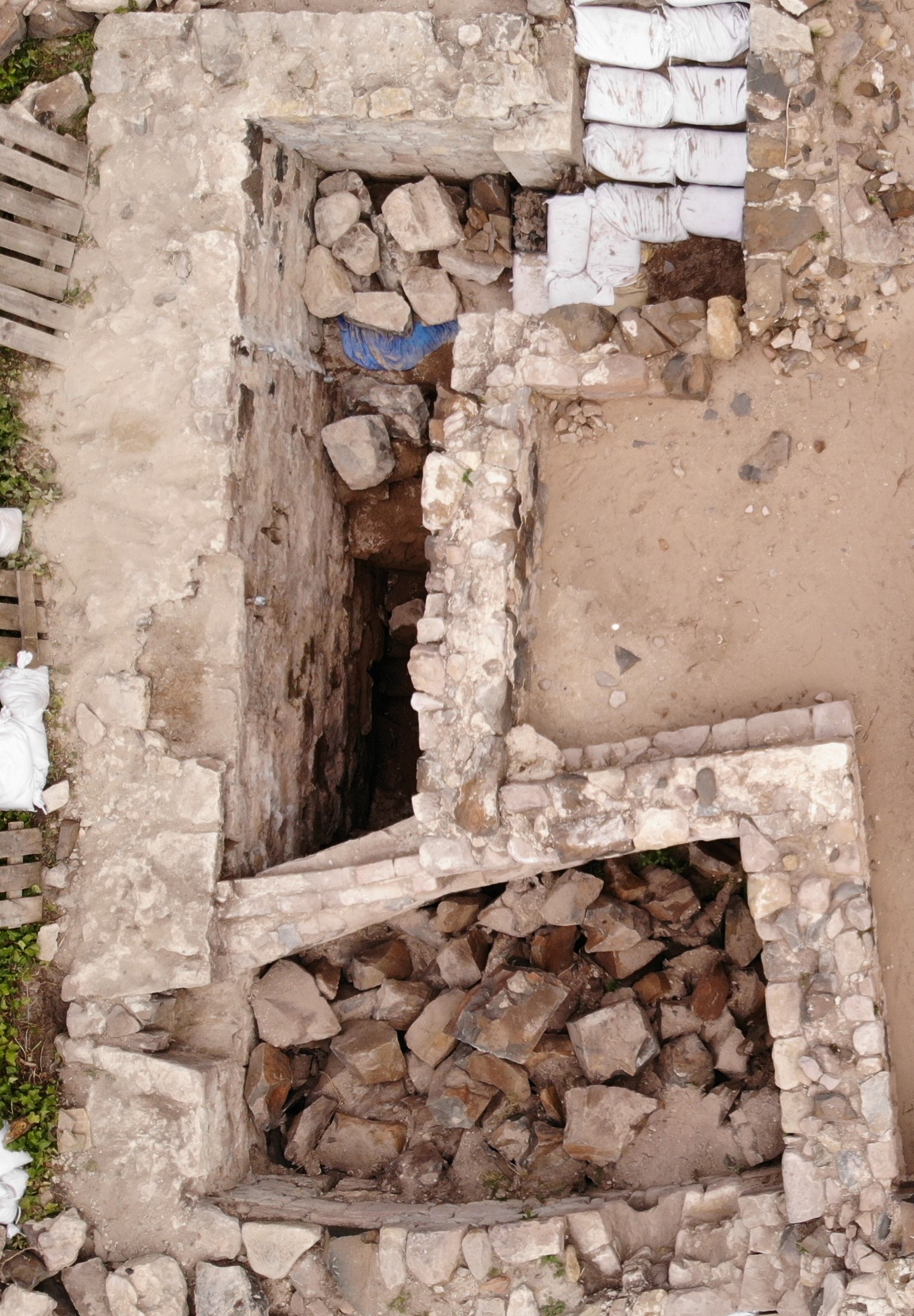
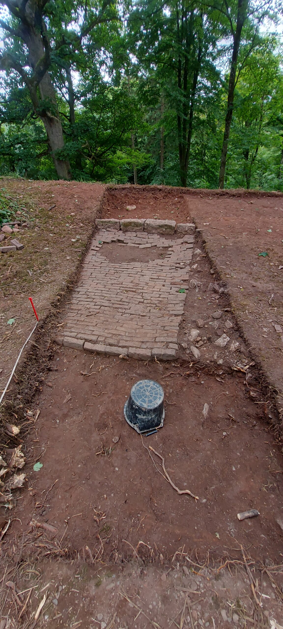
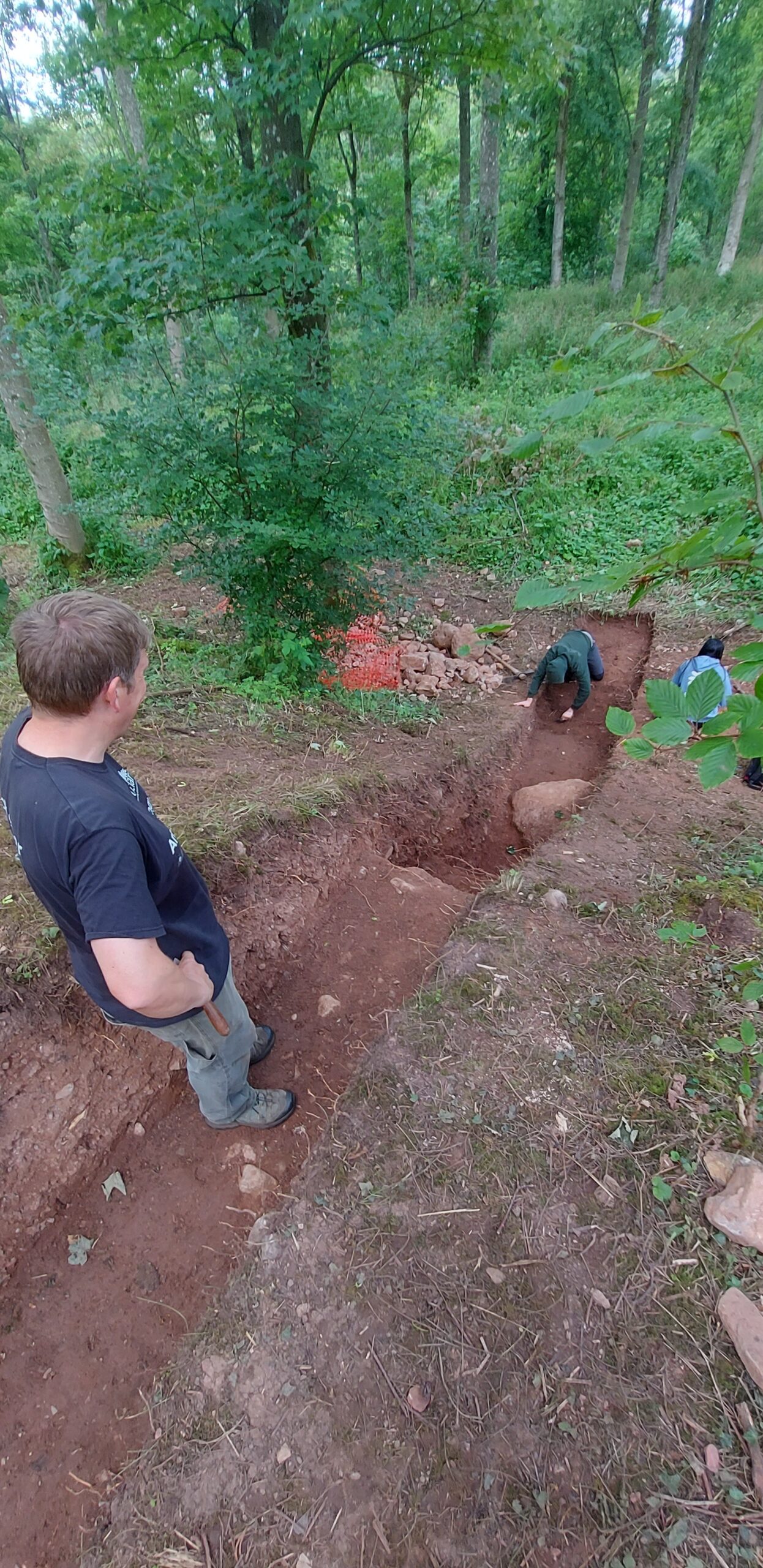
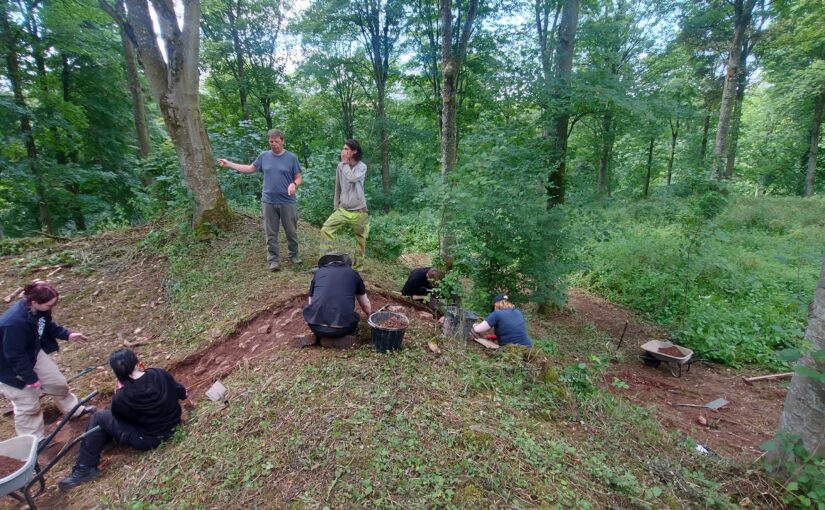
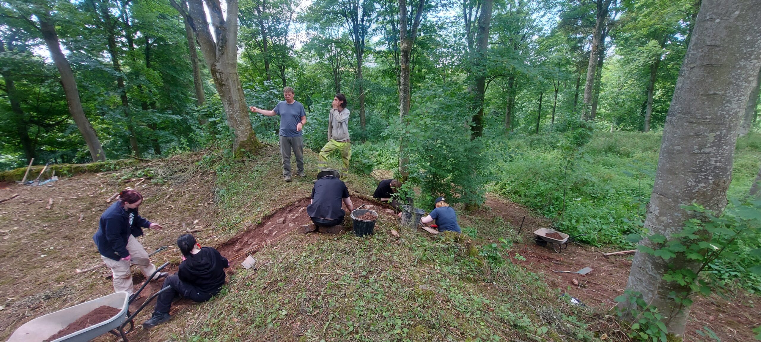
The archaeological remains observed in Trench 19 (Fig. 1) appear to demonstrate the presence of a heavily robbed-out building with structures of two later phases overlying it (Fig. 2). The orientation of the first structural phase (contexts 1912 and 1916) and the robber trench (context 1908) associated with it is in alignment with the south-facing elevation of Thorpe Tower. This orientation suggests that this first phase was associated with, and presumably connected to, Thorpe Tower. It is probable, therefore, that context 1912 represents a heavily robbed wall which is comparable, and most likely contemporary with, wall J3, identified by the 8th Earl, who was an amateur archaeologist, which extended from the northern elevation of Thorpe Tower (TBGAS, 1927, vol.49, 183-93 & 1938, vol.60, 308-39).

Figure 2 – Location of proposed donjon overlying plan of 8th Earl’s excavations. Copyright Berkeley Castle Project

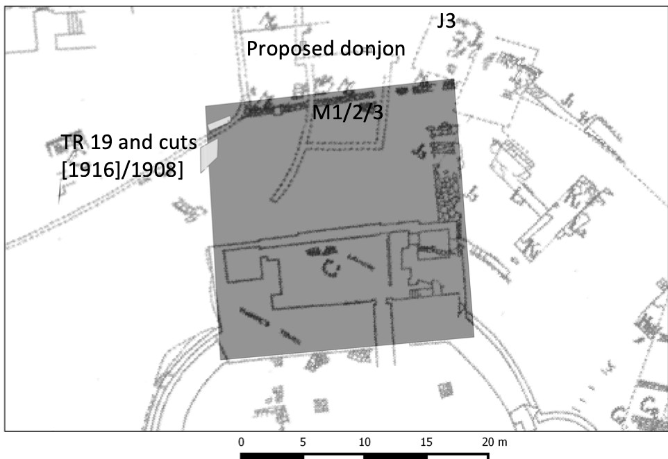
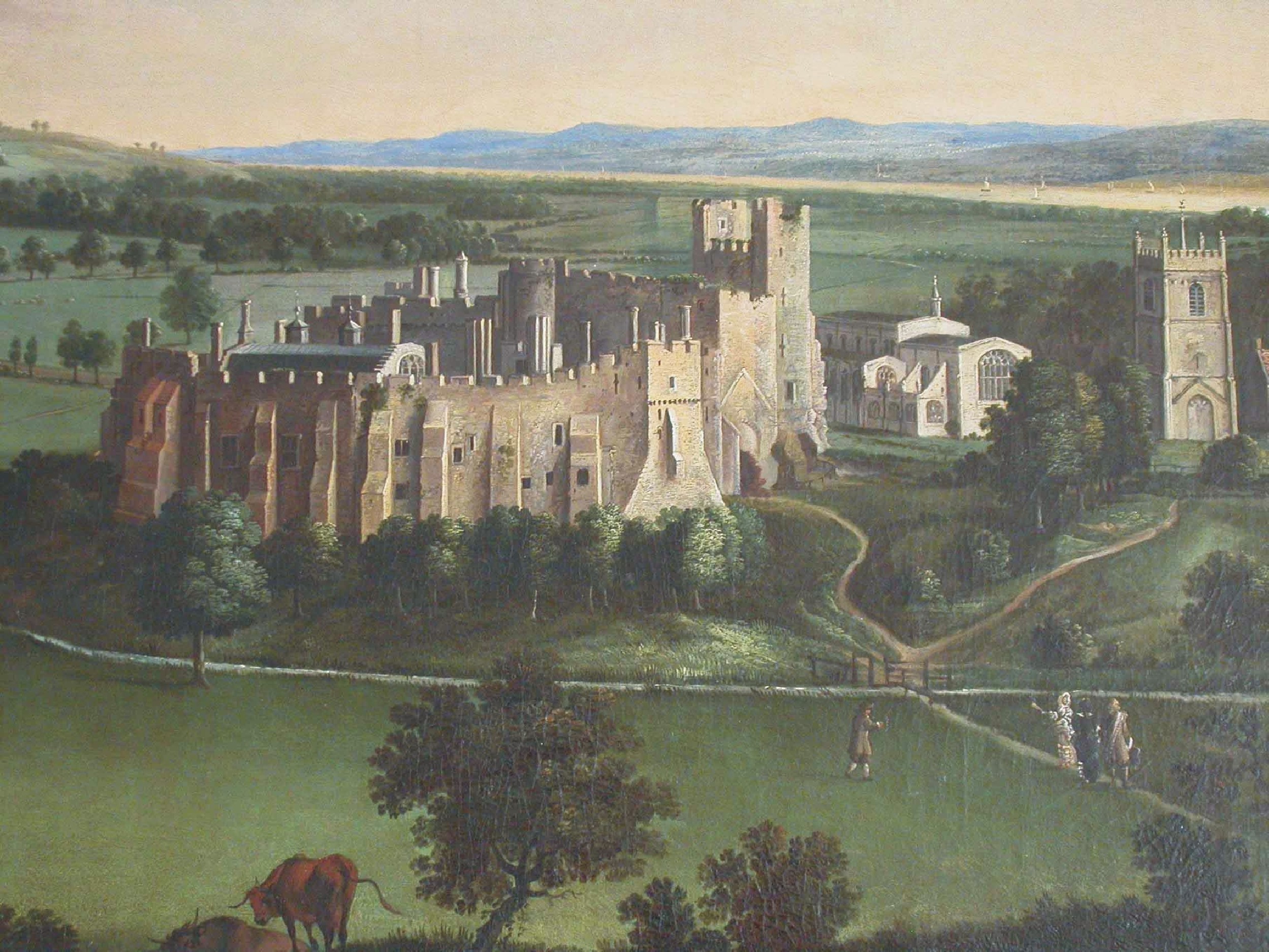
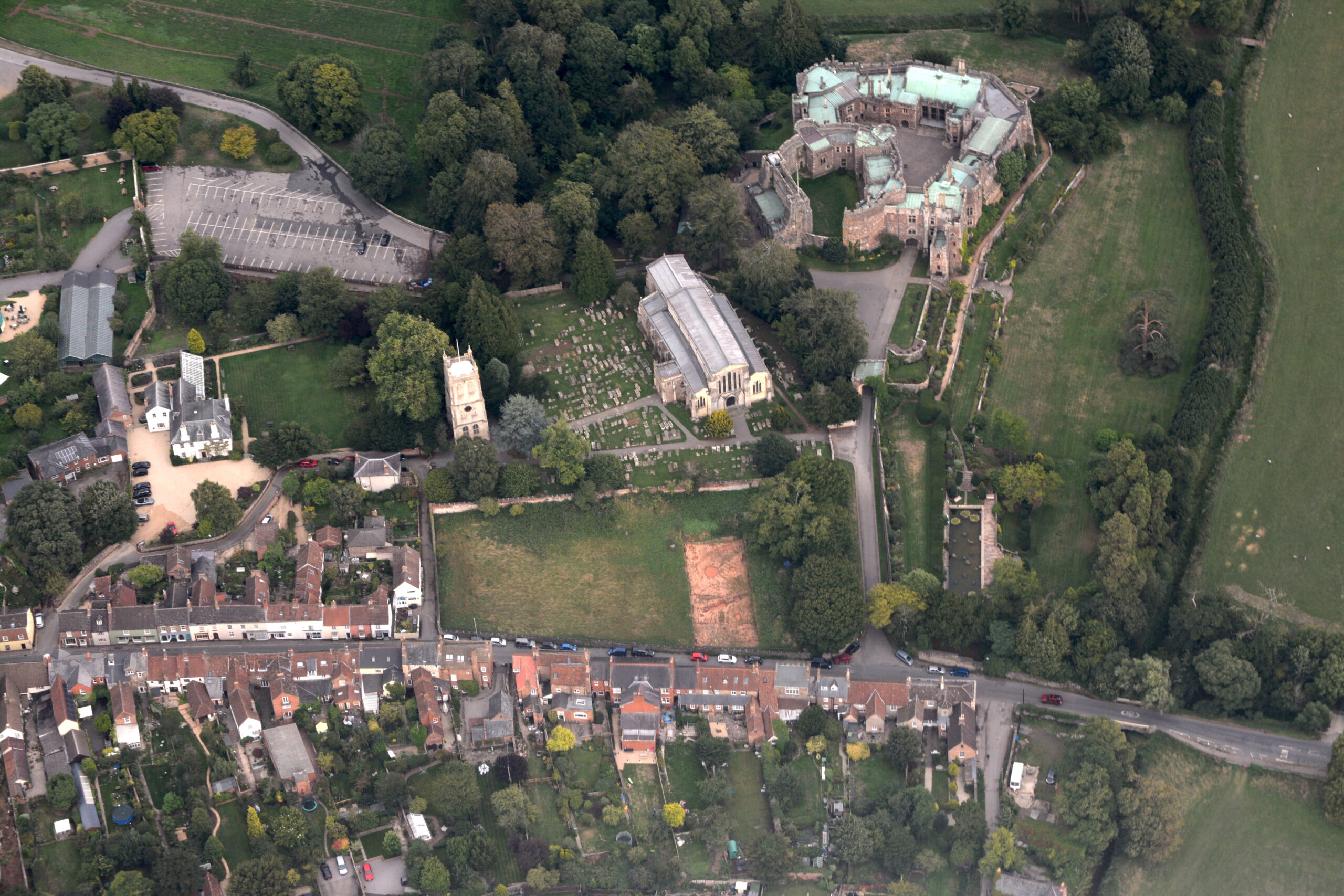
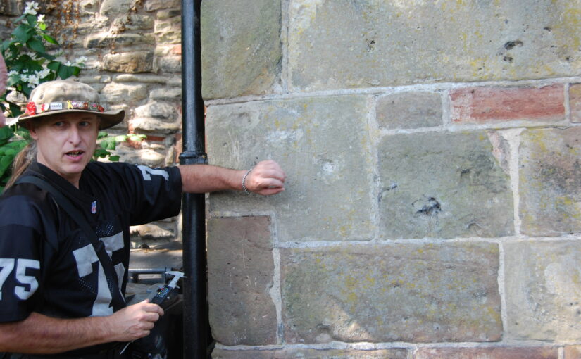
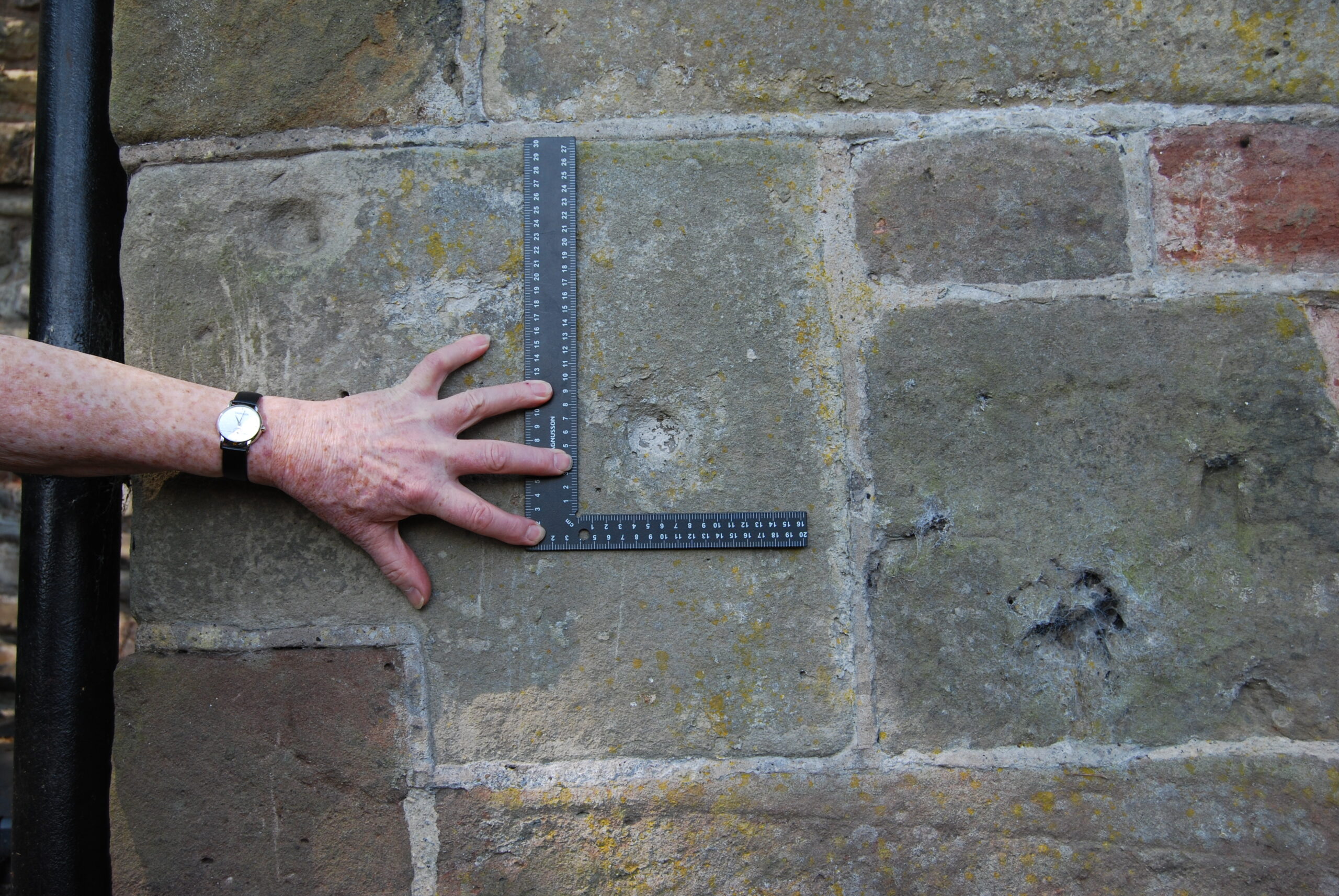
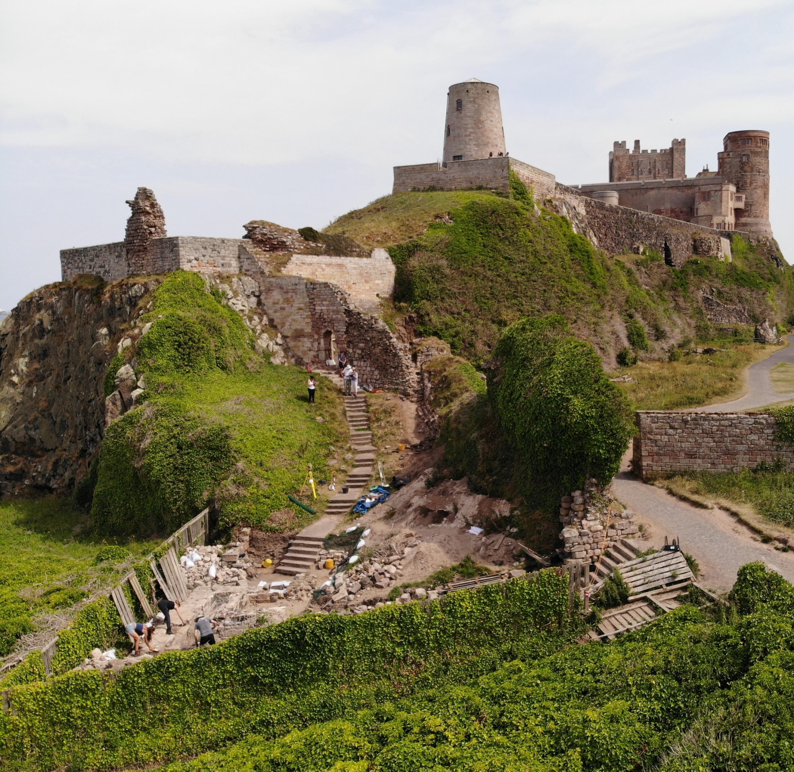
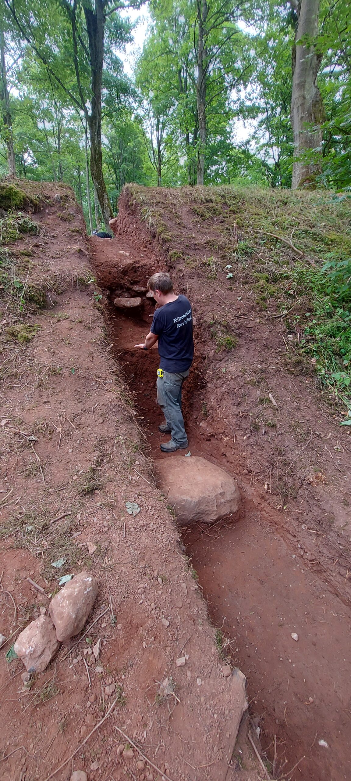
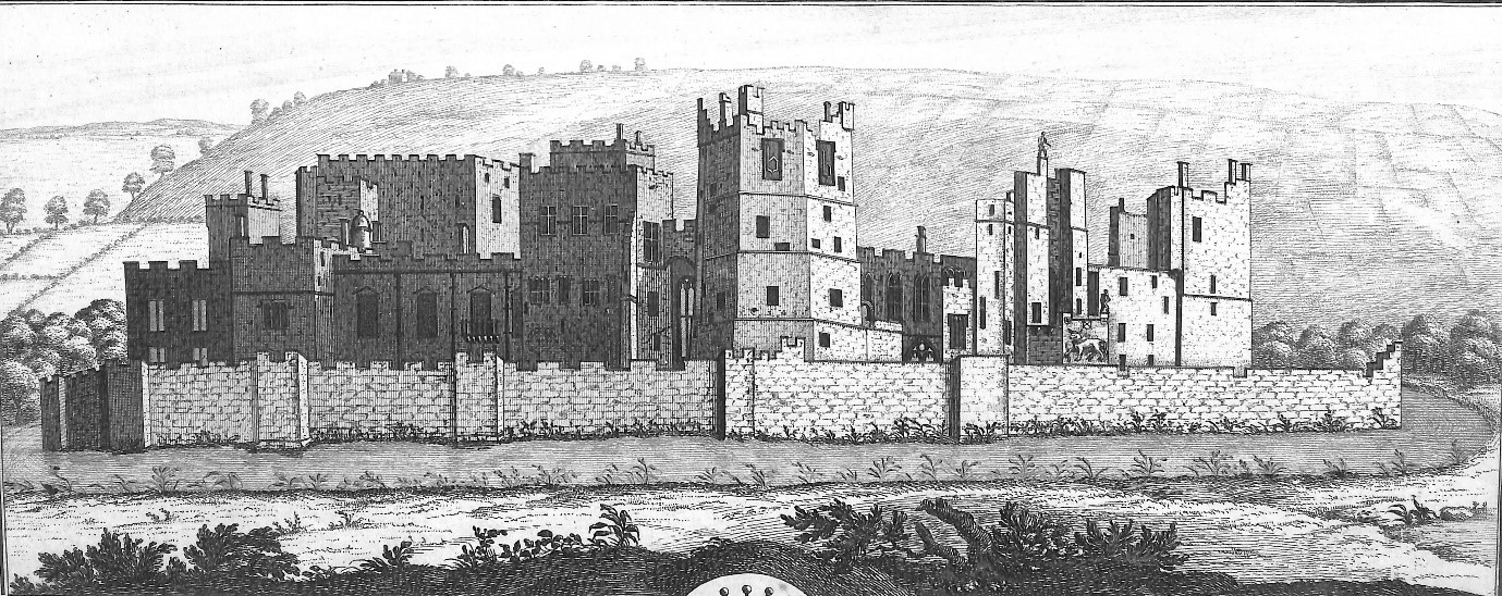
It appears then that the shell-keep and Thorpe Tower are of a single phase, most likely dating to the mid-12th century. While there is no evidence currently that contexts 1912, 1916 and wall J3 are contemporary with this primary construction phase, it must be noted that the wall (1911) overlaid context 1912 and re-used some of its stone. Further to the evidence from Trench 19, the rear wall of this fortification can still be seen, incorporated into the castle’s later form (Figs. 3 & 4).

Figure 3 – 17th century painting by Dankerts showing original height of donjon along with remnant of projecting wall (heading north towards church).
Figure 4 – Aerial view of Berkeley showing reduced height of donjon; and with addition of 18th century laundry attached to north. Copyright Berkeley Castle Project

Accompanying the donjon, there are several medieval documents that record the cutting of moats around Berkeley Castle. In The Cartulary of St Augustine’s Abbey, Bristol, an entry made between 1171 and 1190 records a grant made by Maurice de Berkeley [I] to St Augustine’s of a rent of 5s from his mill below the castle, some tithes of pannage, and common pasture for a plough team ‘pro emendatione culpe mee de fossato quod feci de cimiterio de Berchel circa castellum meum’ (charter no. 78; Walker, 1998, 46–7), which roughly translated means ‘in recompense for my offence committed upon the cemetery of Berkeley in cutting a ditch around my castle’. This suggests that Maurice cut a moat around his castle, which encroached upon part of the cemetery, and he was subsequently fined for his actions. The grant is again confirmed sometime between 1190 and 1220 by Maurice’s son, Robert [II] (charter no. 119; ibid., 69–70).

During this period then, the castle comprised an ovoid shell-keep with adjacent forebuilding, the curtain wall of the inner ward and the Norman Great Hall, all wrapped around the skeleton of the earlier motte and bailey. Excavations carried out by the 8th Earl between 1917 and 1937 (TBGAS 1938, 321) demonstrated that the shell-keep was already adequately defended by a moat that ran around its base on the southwest, north-west and north-east sides – which may have encircled the earlier motte and bailey – and records show that Maurice [I] dug a deep moat around the south-east side of the castle, presumably to complete the defensive circuit, and diverted the Newport brook and others towards the castle to fill it.

More information on the Berkeley Castle Project (BCP), on the castle itself, and on the excavations and survey work conducted by University of Bristol can be found here: https://www.archaeopress.com/Archaeopress/Products/9781803275680

Subscribe to our quarterly newsletter

Bibliography

Earl of Berkeley, 1927. Berkeley Castle. Transactions of the Bristol and Gloucestershire Archaeological Society

49, 183-193.

Earl of Berkeley, 1938. Excavations At Berkeley Castle. Transactions of the Bristol and Gloucestershire

Archaeological Society 60, 308-339.

Walker, D. 1998. The Cartulary of St Augustine Abbey, Bristol. Gloucester: Bristol and Gloucestershire Archaeological Society.

Transforming our understanding of Shrewsbury Castle

With the excavation report on the third and final season of excavation which the CST has funded now published on our website, project lead Dr Nigel Baker looks at what has been achieved since the first work in 2019 to now.

Just over a century ago Shrewsbury Castle began a new phase in its long life. In 1925 its principal surviving building, having been in use as a private dwelling since the castle was finally de-munitioned in 1686, became the meeting hall of Shrewsbury Borough Council, set in extensive landscaped gardens covering the remains of the motte and inner bailey, the outer bailey having (mostly) disappeared beneath the growing town by c.1300. Shrewsbury Castle remained more or less untouched by archaeology for the remainder of the 20th century. This changed in 2019 with the award by the Castle Studies Trust of a grant for a season of geophysical survey and excavation in the inner bailey. Following permission from Shropshire Council, the site owners, and Historic England, its legal guardians, the work took place in May and July 2019, the geophysics by contractors Tiger Geo and the excavation team made up of experienced local volunteers and staff and students of University Centre Shrewsbury. The results were unexpected.

Subscribe to our quarterly newsletter

Shrewsbury Castle Excavation 2019 showing the width of the ditch around the motte using deckchairs (copyright Dr Nigel Baker)
Arrow heads found in Shrewsbury Castle Motte Ditch (copyright Dr Nigel Baker)

Immediately under the turf was natural glacial gravel: the top of the hill on which the castle had been built; the ground surface had been lowered sometime in the past, removing nearly all archaeological remains. This was almost certainly the work of the young Thomas Telford who, from 1786 to 1790, lived in and ‘restored’ the castle for its owner, Sir William Pulteney, M.P. for Shrewsbury. However, archaeological strata were found to have survived within cuts into the natural gravel, and two of these were of major significance. The first was the edge of a previously-unknown ditch around the base of the motte. Medieval cooking-pot sherds of late 11th-13th-century date were found in its lowest excavated layers, along with two armour-piercing crossbow quarrel heads. The second significant find was of a pit containing in its fill a piece of decorated bone and two types of pre-Conquest (Saxon) pottery: Stafford-type ware, distributed widely across the emerging towns of the region and already well represented in Shrewsbury; and a limestone-tempered fabric, TF41a, never before seen in Shrewsbury, which had been made in the Gloucester area and probably imported up the Severn. This confirms that there was pre-Conquest activity on the site of the castle, and, along with the Domesday evidence that there was a church of St Michael there by 1086, may point in the direction of a high-status pre-Norman presence on this tactically-significant site controlling access to the ancient borough.

Shrewsbury Castle Excavation 2020 (copyright Dr Nigel Baker)

Excavation resumed in the autumn of 2020 with a trench seeking a sample profile through the west rampart of the inner bailey. This turned out not to be medieval in date. Both the west and the north rampart were probably created as part of Thomas Telford’s landscaping work in 1786-90. But, intriguingly, below the west rampart there was no sign within the trench of the natural hilltop gravel found close by in 2019 at a depth of just a few centimetres. The explanation may be that the bailey was enlarged westwards between the Norman period and the later medieval period, by dumping soil and levelling-up behind a new curtain wall.

Shrewsbury Castle Excavation 2022 on the motte top (copyright Dr Nigel Baker

The final season of excavations took place in 2022 on the top of the motte, and outside the north curtain wall. Telford is known to have demolished ruined medieval buildings on the top of the motte and replaced them with the surviving two-storey Gothic summerhouse there. Excavation showed that Telford’s activities had, again, removed most of the archaeology but that the foundations of early medieval timber buildings (beam slots, a post pad, post holes) survived where they had been cut into the motte material. No definite trace was seen of the ‘great wooden tower’ which is documented on the motte top until its collapse in 1269-71.

New light was also shed on the motte by vegetation clearance on its south side, revealing for the first time remains of buildings incorporated in the masonry of the retaining walls. This work was undertaken on behalf of Shropshire Council for a new conservation-management plan, currently at consultation stage, which includes photogrammetric surveying of all the castle structures. This permanent stone-by-stone record not only forms the basis for the next vital stage of work – identifying and specifying long-needed repairs – it also offers new archaeological insights, including the identification of the probable primary sandstone rubble fabric of the curtain walls. This was in turn followed by some research carried out by Jason Hurst on Civil War musketry damage in 2023 (Potential shot damage at Shrewsbury Castle – Castle Studies Trust Blog) . And now, the process of publishing this body of new archaeological, architectural and historical information is just beginning…

Subscribe to our quarterly newsletter

Potential shot damage at Shrewsbury Castle

Jason Hurst from the University of Leicester’s School of Ancient History and Archaeology and expert on civil war damage to castles looks at the damage at Shrewsbury Castle.

In June this year I went with Dr Nigel Baker, and Dr Morn Capper of University Centre Shrewsbury, to examine suspected musket/weapon projectile damage inflicted on the Castle, possibly during the Parliamentarian assault of February 1645.

Subscribe to our quarterly newsletter

Dr Morn Capper showing the damage to Shrewsbury Castle’s main gate

When inspecting the marks on the main castle gate I concluded that these were from musket/pistol ball strikes with some indication of possible fragments of these projectiles still embedded in the woodwork, along with possible residues.

Shrewsbury Castle Postern Gate Gun Shot Damage

On the outside of the Postern Gate the identification of some of the marks could not be positively made because of weathering, but intriguing larger impact marks seem to be from a small calibre artillery piece, possible a Robinet or similar sized calibre gun.

At the north end of the hall, facing the railway station, are marks that look like weapon projectile strikes but their trajectory is problematic. Some appear to have come in at a level trajectory towards the wall and some from a downward trajectory, so these need to be looked at in more detail to determine what has caused them.

Subscribe to our quarterly newsletter

Contextualising Bamburgh Castle: wells, towers, mounds and more!

Dr Jo Kirton co-director of the Bamburgh Research Project takes a look at the work they are doing at Bamburgh Castle, funded by the Trust.

Throughout 2023 and early 2024 the Bamburgh Research Project will be utilising funding from the Castle Studies Trust to further explore Bamburgh Castle’s medieval outworks, particularly the area outside St Oswald’s Gate where our current excavation is underway as part of our annual field school. Our project is titled ‘Contextualising Bamburgh Castle: wells, towers, mounds and more!

Subscribe to our quarterly newsletter

crForeground shows the area currently under excavation by the BRP with St Oswald’s Gate visible at the top of the steps and West Ward of Bamburgh Castle present in the background.eated by dji camera

Bamburgh Castle

Bamburgh Castle rises from the North Sea coast of north Northumberland. It lies on an undulating, 3.2-hectare, outcrop of dolerite bedrock that stands up to 30m above the surrounding countryside. Bede describes it as a palace site of the Anglo-Saxon kings of Northumbria from the later 6th century and it remained a royal castle until its semi-abandonment after a great siege in 1464. Rebuilt by the Lord Crewe Trust in the 18th century and again by the 1st Lord Armstrong at the end of the 19th, the fortress has long held a special place in the history and culture of the region.

The majority of the archaeological work at Bamburgh has concentrated in the low-lying West Ward at the north of the castle. A complex deeply stratified, finds-rich, site has been revealed archaeologically. By contrast, the Inner Ward of the castle, at the very top of the hill, remains a built-up area. Modest scale excavation of the accessible areas has provided an important balance, giving insight into the heart of the citadel to contrast with the occupation and industrial activities we see in the West Ward.

Aerial shot of St Oswald’s Gate with steps leading down to current excavation area.

St Oswald’s Gate

St Oswald’s Gate and the outworks beyond lie in the area of the original entrance to the castle. It is very likely that the siege castle (named Mal Voisin in the Anglo-Saxon Chronicle) was built close to this gate in AD 1095. When the main access was re-sited, the entrance here remained as an important postern, perhaps serving a small adjacent harbour immediately to the north of the site. This area now forms the BRP’s main investigative focus. The outworks consist of strong walls enclosing a trapezoidal area with the Tower of Elmund’s Well, with a more recent wall and postern to the west.

Map depicting current area of excavation (Base map Crown Copyright/database right 2022. An Ordnance Survey/Edina supplied service).

The outworks at St Oswald’s Gate are a rare case at Bamburgh as they have not been subject to extensive rebuilding in the post medieval period. Other than the reconstruction of the tower as a cottage, the outworks represent an astonishing window into mostly unaltered medieval fabric still standing at Bamburgh.

Aerial shot of Elmund’s Tower and suspected medieval well location.

Work to Date

Recent investigation by the BRP has revealed that a substantial structure still survives below ground. This is in the form of an L-shaped corridor and steps down into the room that is thought to be the tower basement that contained the well. The presence of two splayed narrow windows appears to further indicate that this is part of the medieval Elmund’s Tower. Our primary aim this year is to continue to reveal the full extent of the tower and identify any remains of the well depicted on the 19th century survey. 

Steps down into the room that is thought to be the tower basement that contained the well.
Arch into the well room of the tower

What will the Castle Studies Trust (CST) Funding be used for?

There are two primary aims for the CST funding:

  • The first is to contextualise our recent excavations at Elmund’s Tower through geophysical survey (GPR and Magnetometry) and to undertake a masonry survey of the castle’s associated extant outworks. This will include using photogrammetry to create a 3D model of the standing outworks and internal structures of Elmund’s Tower. The survey will be undertaken in conjunction with a metric survey of the structures outlines. This work is currently underway and we look forward to sharing the results with the CST. You can follow our progress on our blog: https://wordpress.com/post/bamburghresearchproject.wordpress.com
  • The second focus for the funding will be on disseminating our discoveries to the wider public. We will install signage for visitors, who cannot currently visit this area of the castle with a QR code for the 3D model, granting online access to Elmund’s Tower and the wider outworks over the winter period. This information will also be replicated and enhanced with the creation of a new webpage on the Bamburgh Castle website. Alongside these permanent additions we will continue to share our work through our blog and social media.

Subscribe to our quarterly newsletter

Lowther Dig Diary Four: Lots of questions not many answers…yet

At the end of week two of the #LowtherMedievalCastle dig and project lead Sophie Ambler gives us the latest update.

At the end of week two, we’re half way through our excavation of Lowther Medieval Castle and Village, and revealing some intriguing results.

We now have four trenches open, three exploring the medieval castle earthwork and one across the routeway linking castle to village. There is still a great deal of work to be done, so much of what follows involves some speculation, and these findings are very much preliminary!

Subscribe to our quarterly newsletter

Trench One: Brick Patio

Trench One, on the western side of the castle earthwork, has revealed a small brick patio, bounded on the western edge with a course of cut stones. Miscellaneous finds, including a degraded iron doorhandle and pottery sherds, suggest that this might represent a phase of use concurrent with the nineteenth-century castle. Today’s Lowther Castle, the ruins of which overlook the site, was commissioned in 1806 by William, 1st Earl of Lonsdale. One theory is that the patio relates to the ‘Countess’s Stairs’, which once led up the steep slope from the River Lowther – perhaps towards the patio or a now-lost structure, which may have afforded a view across the river.

Trench Two: view down northward slope from top of northern bank

Trench Two, which cuts through the northern bank of the medieval castle earthwork, is starting to give us a real insight into how the fortification was constructed. We might expect with a ringwork castle for the bank to have been built using earth taken from an encircling ditch, but there is no evidence of a ditch at present. Instead, the bank appears to have been formed from material scoured from the immediate area: both the flat stretching north of the earthwork and the steep slope down to the River Lowther, a rich source of limestone. The bank appears to have been constructed in alternating layers of earth and stone. The team will continue working their way through the layers in this trench, in the hope of revealing more of the bank’s construction, and picking up any small finds that will provide us with dating evidence.

Trench Two northern bank of castle earthwork viewed from exterior showing layers of construction demonstrated by Jim Morris of UCLan

At the southern end of Trench Two, within the castle earthwork’s interior, is a metalled surface that may be the original medieval surface. This might tie into emerging discoveries in Trench Four.

Trench Four is our newest trench, opened over the entrance to the castle earthwork on its eastern side. Already this is beginning to yield evidence of what looks to be the same metalled surface evident in Trench Two. If so, this could suggest the original medieval metalled surface leading into the castle from the village and stretching across the floor of the ringwork. No evidence of this surface is evident so far in Trench One, either because it was destroyed by the intrusion of the nineteenth-century patio, or because the metalled surface did not cover the entirety of the castle interior. Within Trench Four, amidst a stone layer to the north of the metalled surface, is what might just be evidence of a post hole. Could this represent one side of the castle’s gateway? Watch this space!

Trench Three is another relatively recent trench taking in what is likely to be the routeway into the castle from the village, and what might be structures or plots lining the routeway. This has so far yielded two patches of disordered stone to the north of the routeway; one theory so far is that these represent demolition undertaken when the village was cleared in the seventeenth century.

All four trenches will hopefully have more to tell us as the team continues work over the second half of the project.

Subscribe to our quarterly newsletter

You can follow the project’s discoveries on Twitter via the hashtag #LowtherMedievalCastle

Lowther Dig Diary Three: Digging up the historical evidence of Lowther medieval castle and village

In part three of our dig diary, project lead Sophie Ambler talks about another type of digging, not of holes in the ground by through the archives to discover what if any historical evidence there is for Lowther.

Whilst the archaeologist are at work on site at Lowther, I’m attempting to piece together the site’s history from the documentary evidence.

Our biggest challenge is tracing the origins of Lowther’s medieval castle and village, which we think date to the late eleventh or early twelfth century. For most of England, historians have a phenomenal source for settlement in the eleventh century: Domesday Book. This was William the Conqueror’s enormous survey of landholding, compiled in 1086. It gives various details, settlement by settlement, such as landholders, land under cultivation, notable buildings and households (for an introduction to Domesday and the latest research, listen to this BBC History Extra podcast by Professor Stephen Baxter). Domesday thus helps historians to trace the process by which the Normans conquered England over the twenty years from 1066.

Subscribe to our quarterly newsletter

Frustratingly for us, the area of modern Co. Cumbria doesn’t appear in Domesday Book. Because this region wasn’t conquered by William I, it found no place in the Domesday survey. As discussed in our project’s first Dig Diary entry, the region was only conquered in 1092, by William the Conqueror’s son, William Rufus. The Anglo-Saxon chronicle states that William Rufus, following his campaign of conquest, ‘sent many peasant people with their wives and cattle to live there and cultivate the land’. This was, effectively, a process of Norman colonisation. We’re hypothesising that the ringwork castle earthwork and village at Lowther date to this era.

What was this region like when the Normans arrived in 1092? Here, historians have worked hard from patchy evidence for the Kingdom of Cumbria in the tenth and eleventh centuries. This was a Brittonic kingdom (distinct from the Anglo-Saxon kingdom of the south) but, as Professor Fiona Edmonds has described, parts of the kingdom were ‘multi-lingual and multi-cultural’ (including settlers we might think of as ‘Vikings’ and their descendants). These groups were encompassed by the term ‘Cymry’ (‘inhabitants of the same region’), from which the names Cumbria and Cumberland derive.

Who were the settlers dispatched in 1092 by William Rufus to colonise the Kingdom of Cumbria? There’s no hard evidence, but Dr Henry Summerson has suggested (in his book Medieval Carlisle) that they hailed from Lincolnshire. This theory has found some support from the late Professor Richard Sharpe, although he noted that evidence for a Lincolnshire connection dates to around 1100, so may represent a second wave of settlement.

Subscribe to our quarterly newsletter

Our first major evidence for Norman rule of the region comes in 1130, under King Henry I (William Rufus’ brother). This is found in a Pipe Roll – a record produced by England’s central government detailing the Exchequer’s annual audit, so-called because the parchment membranes were sewn together at the top and rolled up to look like a pipe (read more on the Pipe Roll Society website). The first surviving Pipe Roll dates to 1130. Professor Sharpe used this and other evidence to reconstruct the early Norman administration of the region. He concluded that the Normans formed the shires of Cumberland and Westmorland out of the old Kingdom of Cumbria by 1130, and were administering these shires under the aegis of central government. Even then, however, both counties were run ‘as a territorial unit’ rather than shires proper, overseen by an administrator rather than fully-fledged sheriffs. (You can read Professor Sharpe’s analysis in full here). This is perhaps not surprising, given that in southern England the Normans could co-opt the governmental systems of the Anglo-Saxon state, including shires and shire courts. Cumbria was a different beast.

Is this all to say that written evidence can’t tell us much about the Norman conquest of Cumbria in general, or about our site in particular? Yes and no. It does highlight the importance of archaeological investigation in filling the gaps in written evidence – and suggests how findings from the Lowther Castle and Village project could be significant to both historians and archaeologists in tracing the process of Norman conquest and colonisation and its realities on the ground. On the other hand, we do have written evidence for the Lowther site dating from the thirteenth century onwards, which we can use together with the archaeology to trace the site’s biography. More of this in a forthcoming post!

Subscribe to our quarterly newsletter

Follow the project on Twitter via the hashtag #LowtherMedievalCastle.

Lowther Dig Diary Two: End of Week One at Lowther Castle and Village Excavation

At the end of the first week of four, project lead Sophie Ambler gives an update of what has been going on the excavation.

As we draw to the end of our first week of the Lowther Medieval Castle and Village project, the team has made excellent progress.

Before the archaeologists arrived, the ground staff at Lowther Castle prepared the site – a big task, with the mowing of large areas of the north park. In recent years, the Lowther team has been rewilding the estate, allowing the grass and wildflowers to grow as a haven for wildlife. This meant we needed to balance the demands of the project – ensuring ready access for geophysical surveying – with the requirement to preserve this rich habitat as far as possible.

Subscribe to our quarterly newsletter

The LiDAR and earthworks survey (discussed in our first post) allowed us to identify the principal north-south run of the medieval village along the eastern half of the site, together with the road or routeway connecting it to the medieval castle. This was the area we really wanted to survey and which had to be mowed. Meanwhile, a long strip running down the western side of the site, where we expected little medieval habitation, was left unmown. Walking across the site to the church yesterday, I was greeted by a kaleidoscope of butterflies cavorting in this long grass, and was glad we’d made this compromise!

Day One: Rob Evershed from Allen Archaeology leading student archaeologists on the geophysical survey. This is at the southern of the site, atop the village earthworks.

The geophysical survey is now largely complete. It has been led by Rob Evershed, a geophysical expert from Allen Archaeology, with the help of the project’s student archaeologists from UCLan. Rob first staked out thirty-metre grids, before training the students in the patient and disciplined task of geophysical surveying. As I learned this week, this means dressing ready for the task (no metal can be worn at all – including metal clasps and buttons – as it can interfere with the results) and carrying the equipment at a slow and steady pace across the grids.

Day Four: Rob and UCLan student, Dominic Scott, scrutinising the geophysics results.

The results are still coming in, but have already been hugely helpful. Rob was able to plot services running close to the castle (and thus where we shouldn’t be digging) and spot a target for trench three: what looks like a square ditch, potentially associated with one of the dwellings built along the east-west routeway linking the castle to the main north-south run of the village. As I left on Thursday afternoon, the team was busy opening Trench Three, incorporating the routeway and this anomaly, in the hopes of identifying features and finding dating evidence.

Meanwhile, on Monday the team had opened Trench One and Two at the castle earthwork. It wasn’t possible to use geophysics in this area, because the earthwork stands in woodland and the root systems would create too much disturbance for any results to be meaningful. The earthwork had been heavily overgrown but again, in advance of the project, the Lowther team cleared all the long grass and nettles across and around the earthwork.

Day One: the trench across the nothern bank of the castle earthwork, with Jonny Milton from Allen Archaeology (in the high vis trousers) and Jim Morris from UCLan directing the student archaeologists

This not only allowed the archaeologists easy access but also revealed the earthwork in all its glory. I was struck afresh with its scale, particularly its height, and its shape and features are now far easier to discern. The earthwork is roughly square, with an entranceway on the eastern side (presumably accessed from the east-west routeway from the village). At the south-west corner a significant continuation of the bank protrudes to form a platform. The great bank of a ringwork castle would likely have been surmounted by a timber palisade, and we’re speculating that this platform may have been home to a wooden tower, sited to give wide-ranging views north, east and south. Meanwhile, the western length of the castle was protected by a steep slope running down to the River Lowther.

Subscribe to our quarterly newsletter

The two trenches were sited on the north and western sides of the earthwork. Under the guidance of Jonny Milton of Allen Archaeology and Jim Morris of UCLan, the student archaeologists removed the turf and set about digging. The northern trench runs from the castle interior, cutting through the bank and down along the bank’s steep northern slope. We hope this will allow us to see how the bank was constructed and provide dating evidence. There is still a long way to go, but already the trench has yielded a fragment of roughly made pottery, which will be analysed to see if it is early medieval. Over week two, the archaeologists will continue working their way down through the trench, stepping it out to take account of the steep slope.

Meanwhile, the western trench yielded some curious results: a couple of trays’ worth of Victorian detritus, a stone wall, and a floor surface nicely laid with hand-made bricks: evidence that part of the castle interior was taken over and used for purposes that are so far unclear. The team aims to investigate this phase further and, after thoroughly recording these features, to dig further down in the hope that they’ve preserved features from the medieval phase.

Subscribe to our quarterly newsletter

There’ll be more entries in our Dig Diary to follow, and meanwhile you can follow the project’s progress on Twitter via the hashtag #LowtherMedievalCastle.

Lowther Dig Diary One: Lowther Medieval Castle and Village project

On Monday 26 June the excavation and geophysical survey of Lowther’s medieval castle and Village gets underway, finishing on Friday 21 July. Here, project lead Sophie Therese Ambler from the University of Lancaster explains what she hopes the team of students and academics from the university and University of Central Lancaster with the support of Allen Archaeology hope to find over the next three weeks.

Overlooking the Bampton Valley on the edge of the Lake District, the picturesque ruins of Lowther’s nineteenth-century castle are one of the region’s most popular attractions. Less well known are the earthworks immediately to the north, the remains of a medieval castle and village. Preliminary work suggests the site may date to the late eleventh or early twelfth century. If so, it could provide rare evidence of the conquest of Cumbria by King William Rufus and his brother, King Henry I – a generation after the Normans seized control of the rest of England. The site is potentially of national significance but has never been fully investigated.

Subscribe to our quarterly newsletter

Who built the castle and its settlement, when and why? The Lowther Medieval Castle and Village project brings together historians and archaeologists from the North West to uncover the site’s biography.

The Castle Studies Trust has generously funded a survey and excavation, which will take place from 26 June to 21 July 2023. The project team brings together History at Lancaster University, Allen Archaeology, the University of Central Lancaster (UCLan) and Lowther Castle and Gardens Trust.

In the 1990s, the Lowther Estate commissioned a landscape report and earthwork survey. The report suggested that the Castlesteads earthwork dates to the early Norman era (late eleventh or early twelfth century), and categorised it as a ringwork, a characteristic rural castle form of the early post-Conquest period. It noted that the castle is ‘of considerable archaeological importance, particularly as it was potentially the original fortified site at Lowther’.

The report also suggested the village was integrally linked to the ringwork and ‘likely to have been a planned settlement, established under close manorial control’. The settlement, the report noted, ‘is of considerable importance being a fossilised medieval settlement and it has the potential to significantly inform our understanding of medieval nucleated settlement in Cumbria.’ At the north of the site stands St Michael’s church, which is medieval in origin and potentially related to the castle and settlement.

Lidar image showing the extent of Lowther Castle and Village

The extent and form of the site as a whole can now also be seen in LiDAR imaging (see image above), noting that the circular features are intrusions brought by landscaping after the demolition of the settlement in the seventeenth century. 

The working hypothesis is that the site dates to the Norman conquest of Cumbria. Unlike the rest of England, Co. Cumbria was not conquered by the Normans in 1066. The region was historically part of the Kingdom of Cumbria, which stretched from Strathclyde across the Solway. Then, while the Normans were conquering lowland England, the area from Lowther northwards was conquered by the Scottish king Máel Coluim III. Cumbria was only annexed by the Normans in 1092, when William the Conqueror’s son, William Rufus, led an expedition to the area. According to the Anglo-Saxon Chronicle, the king then ‘sent many peasant people with their wives and cattle to live there and cultivate the land’.

Subscribe to our quarterly newsletter

Could Lowther’s medieval castle and village date from this era? Beyond the estimations provided by the earthwork survey, it has been suggested from place name and field pattern evidence that many medieval villages in this area of Cumbria were planned or remodelled settlements established following the 1092 annexation of Cumbria and peopled largely by colonists. But written evidence for Cumbria in this era is extremely sparse, so it is up to archaeology to test this theory. Whatever the investigation finds, the archaeology at Lowther offers a fantastic opportunity to understand rural castle building and life in medieval Cumbria.

In the first few days of the project, the team will conduct a geophysical survey, before opening trenches across the Castlesteads and settlement earthworks. Visitors to Lowther Castle will be able to visit the dig site – if you are in the area, please do come and say hello.

The team will be posting regular updates on the project in a Dig Diary here on the Castle Studies Trust website. You can also follow the project on Twitter, via the hastag #LowtherMedievalCastle

Meanwhile, further information is available on the project website:

https://www.lancaster.ac.uk/centre-for-war-and-diplomacy/lowther-medieval-castle/

Subscribe to our quarterly newsletter

Raby Castle: Mapping the Hillocks

As the Castle Studies Trust funded part of the project to learn more about Raby Castle comes to a close, the funding of the digital modelling of Raby’s exterior, the castle’s curator, Julie Bidescombe-Brown explores what they have found so far which includes a short preview of the model in its glory.

Throughout 2022, the team at Raby Castle has been working with Durham University Archaeological Services on a project funded by the Castle Studies Trust to drone scan and create a digital 3d model of the entire castle exterior. At the project draws to a close, Raby’s Curator Julie Biddlecombe-Brown reflects on the work undertaken over the last year, including both the planned outcomes and unexpected benefits of the work undertaken.

Subscribe to our quarterly newsletter

‘At the time of writing this blog, I am waiting with bated breath for an email that marks the end of a truly game-changing project for Raby Castle. The email will include the final embedded link to a detailed digital model of Raby Castle’s exterior produced over a series of drone scans during the summer months of 2022. The sneak preview given to the castle team was breath-taking. When we applied to the Castle Studies Trust for support for the grant I had no idea of the level of detail that the technology now enabled. My initial application for funding was based on the creation of a digital model that could be used as the basis for future interpretation; a tool for presenting the castle to new audiences. What we have achieved has ended up to be so much more.

For those not familiar with Raby Castle, this beautiful building in the south of County Durham has remained the family home of the Vane family for almost 400 years. Harry Vane, twelfth Baron Barnard is the current owner and along with his wife, Lady Kate Barnard, has set out ambitious plans to ensure the future sustainability of the castle and wider estate. This project reflects their vision, setting out to better understand the estate so that responsible stewardship of rich heritage assets can see the castle enjoyed and studied by future generations.

Donate to support our work

Going back to the castle itself: from the exterior, it is one of the most intact 14th century castles in the north of England, adapted over the centuries to provide luxurious accommodation for the two families who have lived here. First, the medieval northern powerhouse of the Neville Family who lost the castle after the failed Rising of the North. It was the Neville family who created most of what can be seen today, their license to fortify the castle having been granted by Bishop Hatfield of Durham in 1378.  Second, the Vanes, later Barons Barnard, Earls of Darlington and Dukes of Cleveland came to Raby after purchasing the castle in 1626. Over two hundred years later, what remains the castle’s most comprehensive history was written by Catherine Lucy Wilhelmina Vane, the 4th Duchess of Cleveland, in 1870,  a formidable scholar and biographer whose engaging narratives combine clear research of the sources available to her, with a delightful peppering of artistic license. Her handbook has also been a useful tool in this project, with descriptions of alterations, anomalies and observations that come with complete familiarity with a site. The Duchess clearly loved the castle and during the late 19th century welcomed guests from across the globe. Earlier generations of her husband’s family down-played the castle’s splendour. Courtier Sir Henry Vane, who bought the castle in 1626 twice received Charles I there; first in May, 1633; and again in April 1639.  Charles is said to have been greatly struck by the size of the castle, and to have rebuked Sir Henry for speaking of it somewhat irreverently as a ‘mere hillock of stone.’  ‘Call ye that a hillock of stone? By my faith,’ said he, ‘I have not such another hillock of stones in all my realms.”

Images of Raby Castle have been captured for centuries. Above: 1728 Engraving of Raby Castle from the southeast. Samuel & Nathaniel Buck. These topographical images, whilst subjective and sometimes inaccurate, have provided a valuable source in considering the appearance of the castle in the past. Such images shed light on demolished features, such as the barbican depicted here on the eastern (left hand) side of the castle which then has the potential to be ‘virtually reconstructed’ on the base digital model,  

You can judge the latest capturing of ‘the hillock’ yourself, by viewing the model funded by this project. Available to the castle team in multiple formats, from a wireframe for digital manipulation to fully overlaid with photographs for a full ‘photo-real’ view, the scan has created a snapshot of the castle at a moment in time but helps us look backwards into its history and forward, securing its future.  The Raby team is working with Heritage Interactive, sector AV specialists to adapt the model to be public facing and engage visitors with the story of the medieval fabric in a new introductory film that we will launch next year. But the model also gives us the potential to add to this; to explore later phases of development in the same way, to isolate, interpret and even digitally rebuild key features that have changed over time, such as the removal of the 14th century barbican in the late 18th century, creating the now slightly confusing Chapel Gateway, or exploring the remains of passages, staircases and windows that make no sense in the current configuration of the building.  

Subscribe to our quarterly newsletter

The base-line data has multiple benefits – in addition to creating new films, we are exploring 3d printing of a model of the castle in jigsaw puzzle-like sections for use with schools and other audiences – what better way to inspire a new generation of castle enthusiasts than to couple the challenge of a puzzle with a superb digital model? The level of detail will also be of huge benefit to the castle buildings team in monitoring condition, working in tandem with our conservation architects who can now view the fabric almost stone-by-stone. This will, we anticipate, not only help us to detect any building changes that might need attention but will also help us in master planning for the future.

A complimentary annex to the project, funded in-house is an archaeological report by Durham University Archaeological Services that will sit alongside the model.  This collation and analysis of source material – including what we have learned about the existing fabric – has been led by Senior Archaeologist Richard Annis who over the course of 2022 has delved into every nook and cranny of the castle – peering under floorboards, climbing disused staircases and opening the door of every built-in cupboard to see what lies behind. This level of survey has never been done and when linked to the model, and an examination of known archival and other documentary sources compiled by a willing group of volunteers, we start 2023 with a far better understanding of this remarkable building than ever before. The report and model will be used together by the castle team including custodian, curatorial, archive and buildings teams,  and of course our conservation architects as we care for and interpret the castle and will be available as a resource to scholars and academics, hopefully inspiring future research.

And of course, there is still research to be done! The project may have answered questions but has left us with many new ones. Over the coming months, or should that be years …  we will continue to explore some of the puzzles of the building, from the origins of some of the towers, to vertical access routes. But what has changed over the last year is that we now have a superb data set as a starting point. Our thanks go to Archaeological Services Durham University and in particular Richard Annis for bringing their enthusiasm, skills, expertise and inquisitive minds to the project, and also, of course, to the Castle Studies Trust which provided us with the funding to enable it all to happen.

Subscribe to our quarterly newsletter

Donate to support our work

The Castle Studies Trust five projects for 2023

The Castle Studies Trust have awarded five grants totalling £35,000 to support research into castles. This is a record amount for the Trust, and as we enter our tenth year as a charity, we could not have managed this without our supporters.

We will bring you updates from these projects throughout the year as the teams get stuck in. But first, let’s get to know them a bit better. They are from across England, Scotland, and Wales and take different approaches to understanding castles.

Subscribe to our quarterly newsletter.

Bamburgh

A stone building with a square tower in the middle. It stands on an outcrop, prominent in the landscape. In the foreground is a beach.
Bamburgh Castle on the coast of Northumberland. Photo by Michael Hanselmann via Wikimedia Commons, licensed CC-BY-SA 3.0.

Standing on a rocky outcrop on the coast of Northumberland, Bamburgh’s history stretches back to the early medieval period when it was home to a palace of the Kings of Northumbria. Bamburgh Castle itself was owned by royalty at various points, and rebuilt in the 18th century.

Bamburgh is a massive site: its history has been illuminated by excavations, and there is still more to learn.

Dr. Joanne Kirton and Graeme Young of the Bamburgh Research Project plan to carry out a geophysical survey and a masonry survey of the castle’s outworks.

Dunoon

The mound at Dunoon Castle. Photo by Rosser1954 via Wikimedia Commons, licensed CC-BY-SA 4.0.

A castle at Dunoon was first mentioned in the late 13th century but may be older. The ruins visible today date from the 14th century. It stands on a hill on the coast of the Firth of Clyde. The castle was besieged and captured multiple times over its centuries-long history and became a royal residence.

Despite the castle’s royal links, little is known about its layout and dating. Dr. Manda Forster’s team at DigVentures will carry out geophysical surveys (resistivity and magnetometry) of the mound and the area around it to find out where there may be buried walls, foundations, or other archaeological remains.

They will also organise workshops for the local community to learn how geophysics work. So as well as learning more about the castle, they may inspire the next generation of archaeologists!

Lowther

Google Map of the medieval Lowther Castle

The present Lowther Castle was built in the 17th century, but a few hundred metres north lie the medieval remains of a castle and possible deserted village. Lancaster University Archaeology Unit surveyed the earthworks in the 1990s, but there has been no other archaeological investigation since.

Being able to date the site would be a crucial step in understanding the Norman influence in the region. Could this be part of the remains of the Norman conquest of the Kingdom of Cumbria in the late 11th century?

Dr. Sophie Ambler has devised the project to carry out geophysical surveys at Lowther Castle followed by excavations. Working with the University of Central Lancashire and Allen Archaeology, this aims to establish the site’s building chronology.

Picton

Picton Castle in 2021 by Ruth Sharvile, via Geograph. Licensed CC-BY-SA 2.0.

Pembroke’s Picton Castle is a medieval building with later alterations and additions. It is uncertain when it was built and by who, but it is likely to have been established in about 1300 by Sir John Wogan. Picton has an unusual layout but may have parallels with French medieval castles.

Neil Ludlow and the Dyfed Archaeological Trust will carry out a measured survey of the building, recording its structure and creating a photographic record of the site. This will be an invaluable resource to understand the site, and help show the castle’s development over the centuries.

Wigmore

Photo of Wigmore © Philip Hume

Wigmore was amongst the early castles established in England in the wake of the Norman conquest. It was founded by William Fitz Osbern, Earl of Hereford and later became the home of the Mortimer family. They were an influential family in the Welsh marches, and they developed the castle to reflect their growing power.

Small-scale excavations at Wigmore and geophysical surveys in the 1990s demonstrated the archaeological potential of the site, but what is missing is a reconstruction of how it looked during its heyday.

Chris Jones-Jenkins will create a reconstruction of how Wigmore Castle used to appear. This will draw on archaeological and historical sources to bring the reconstruction to life. You may also have seen Chris’ work with his reconstructions of Ruthin and Holt.

Subscribe to our quarterly newsletter to receive updates on these projects and our other ongoing work in the field of castle studies.

Header image: Bamburgh Castle by Michael Hanselmann via Wikimedia Commons, licensed CC-BY-SA 3.0.