Ellesmere Castle: geophysics points the way for future investigation

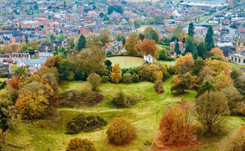
Local volunteers Gary Bick and Nick Cull along with Heneb archaeologist Chris Matthews look at the new survey work funded by the Castle Studies Trust that has helped clarify the buried archaeology of Ellesmere Castle, including the likely extent of its bailey.

Subscribe to our quarterly newsletter
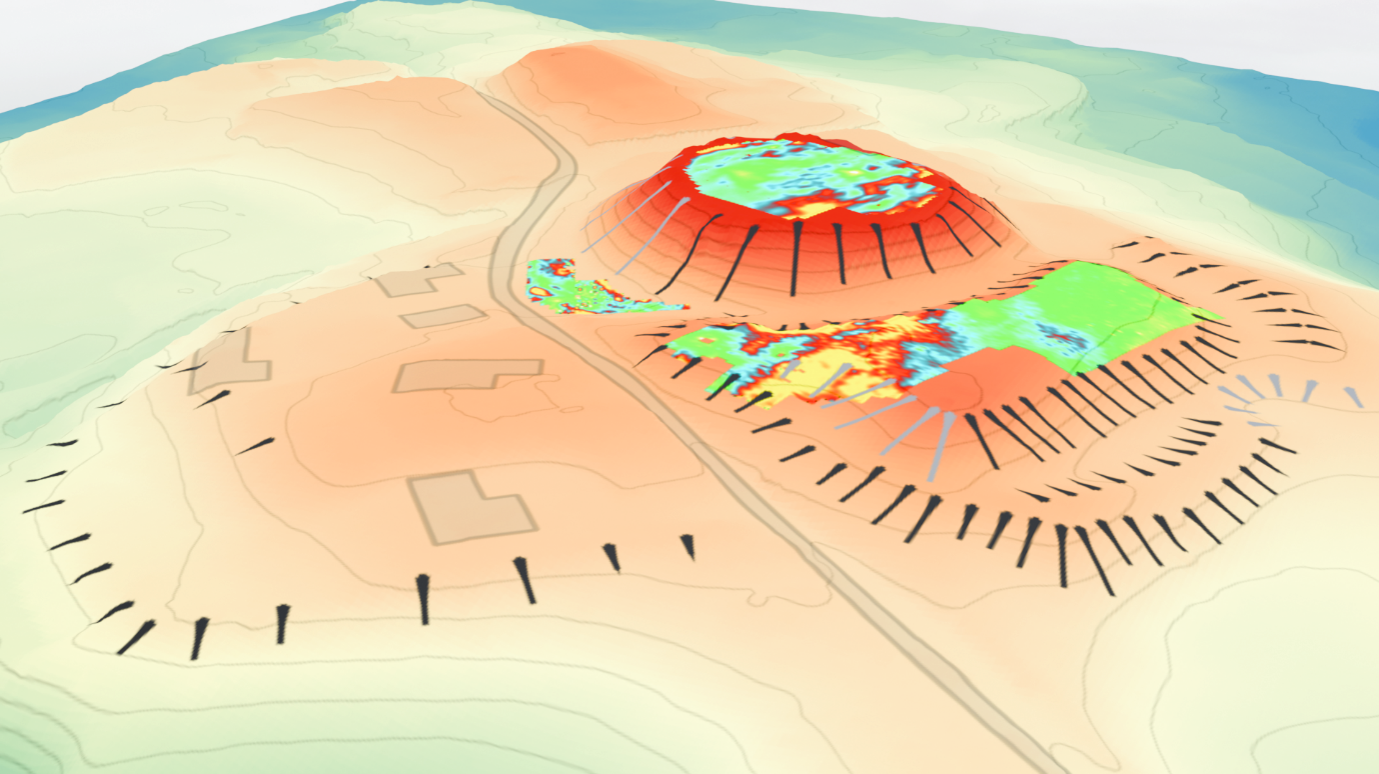
Figure 1: Aerial plan of Ellesmere Castle overlaid with the results of the geophysical survey results. Copyright Heneb

Local Beginnings

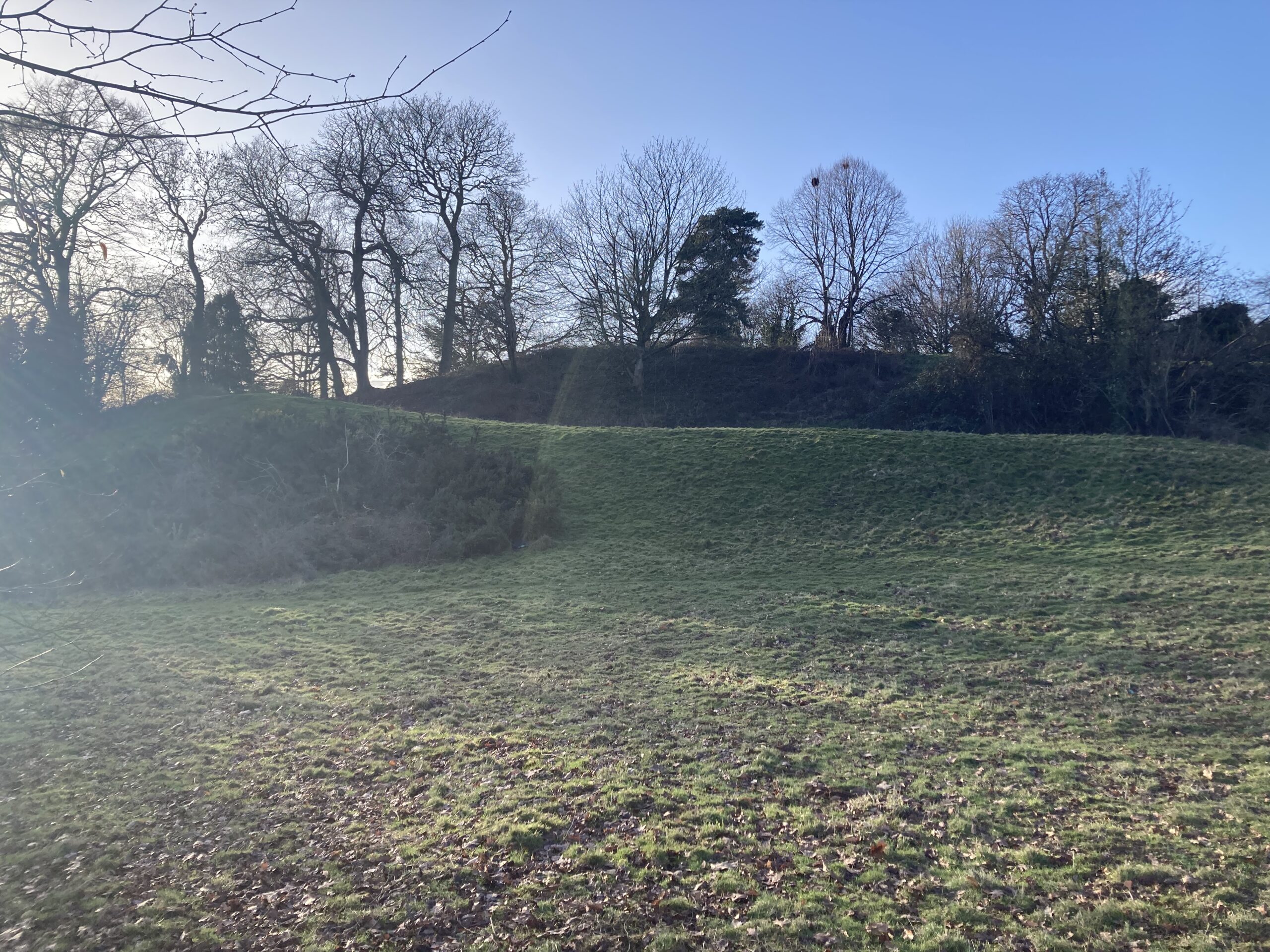
Ellesmere is a small market town in Northeast Shropshire, close to the England: Wales border, well known for its meres and the Llangollen Canal which passes by the town. Disappointingly, Ellesmere Castle does not figure significantly in any publicity or description of the town, not least because there are no physical remains other than a large motte, now used as a bowling green, and earthworks defining the bailey.

The Castle was probably built towards the end of the 11th Century and played a part in the Marcher disputes between England and Wales. Most notable among its “owners” was Llewelyn, Prince of Gwynedd who had been given the castle by King John as a wedding gift when he married John’s daughter Joan. The castle appears to have fallen into disuse by the late 15th Century , Leland recording that there “used to be a Castle” at Ellesmere, in the mid 16th Century.

Subscribe to our quarterly newsletter

The castle site presumably lay deserted for a couple of hundred years until the late 17th/early 18th Century when a bowling green was created on the motte. Crown bowls have been played there ever since, making it almost certainly unique as the oldest crown green bowls in the country played on a circular motte.
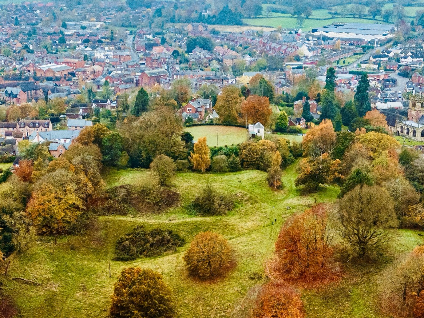
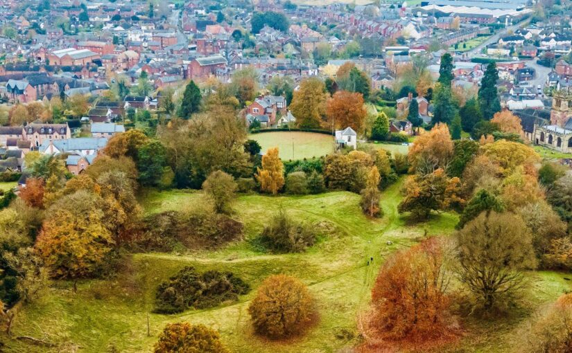
Figure 2: View of Ellesmere Castle from the east, showing motte, bailey and earthworks. Copyright Joe Bickerton Photographs

And so it was in the summer of 2023 that Gary Bick and Nick Cull, Ellesmere residents, were playing bowls at the castle site and started a conversation as to why no significant efforts had ever been made to look for evidence about  the configuration and construction of the castle. That led to the involvement of, and valuable advice from, Dr Nigel Baker via the Shropshire Archaeological and History Society, and Christopher Jobson, local historian. Wider conversations about funding and next steps then led to a stroke of huge good fortune with a ground penetrating radar survey of the motte donated by Adam Cook of Subsurface Measurement Technology in 2024.

The results of that survey which strongly suggested masonry remains under the motte only served to kindle a greater interest and led to an application for a grant from the Castle Studies Trust.

In May 2026, Heneb: The Trust for Welsh Archaeology carried out a programme of non-invasive geophysical investigation at Ellesmere Castle in Shropshire, led by Chris Matthews, Senior Project Archaeologist.  Funded by the Castle Studies Trust and undertaken on behalf of Ellesmere Bowling Club and Shropshire Council, the work aimed to improve understanding of a scheduled motte-and-bailey castle and build on Adam Cook’s ground penetrating radar survey of the motte.

Subscribe to our quarterly newsletter

The Expert View

Ellesmere Castle was once an important medieval stronghold within the shifting political landscape of the Welsh Marches. Very little is known of the earliest phases of the site; however, documentary sources indicate that at least parts of the castle had developed beyond an original earth-and-timber phase into a stone-built fortification, comparable with other nearby marcher sites such as Knockin, Whittington and Oswestry. Today, however, no masonry is visible above ground. This does not appear to have resulted from Civil War destruction, as is often the case elsewhere; instead, later accounts suggest that much of the castle had already been dismantled by the 16th century. The new surveys therefore offered an opportunity to assess whether buried remains of the castle still survive.

The investigation combined several complementary techniques. High-resolution magnetic gradiometry was used across the accessible parts of the motte, bailey and surrounding open ground, while targeted electrical resistivity survey helped test areas where stonework or rubble might survive. The new results were also considered alongside the earlier ground penetrating radar data, LiDAR modelling and historic aerial photography.

Each method responds to different buried conditions. Magnetic survey can pick up ditches, burning, ferrous material and disturbed deposits, while resistivity can be  useful for identifying concentrations of stone, with areas that retain moisture often producing contrasting low-resistance responses. Together, these techniques provide a broad picture of what may survive below the present ground surface, while also identifying the questions that only future targeted excavation can resolve.

Subscribe to our quarterly newsletter

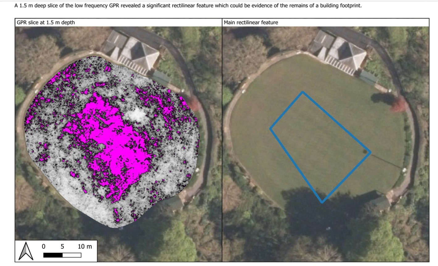
Perhaps the clearest geophysical evidence came from the motte itself. Here, the combined survey results point to a substantial rectilinear feature beneath the bowling green visible in all three datasets, probably representing surviving masonry associated with the castle’s keep. The earlier ground penetrating radar data suggest remains beginning at around 1.1m below the surface, with internal voids and associated demolition deposits also indicated (Fig. 1). The GPR also appears to preserve evidence for the probable original outline of the motte summit, adding weight to the interpretation that the establishment of the bowling green significantly reworked the mound by enlarging its usable surface.

Another supporting aspect of this was noted in the GPR interpretation, which in an archaeological context would typically look to higher-frequency data for more detailed responses at shallower depths. At Ellesmere, however, it was the lower-frequency data that produced the most informative results. One possible explanation is that clay capping associated with the later reworking of the mound for the bowling green limited the effectiveness of the radar at shallower depths, meaning that the deeper-penetrating data provided the clearer picture.

Another strong anomaly may represent a well, shown as a consistent void in the GPR, while further responses on the south-eastern side of the motte could reflect shallower structural remains or spreads of rubble. Taken together, the evidence implies strong potential for significant buried archaeology despite the later landscaping, but point to logistical challenges in exposing the remains due to the deep overburden.
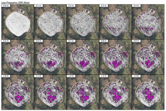
Figure 3: Low frequency time slices of Ellesmere’s motte from the GPR survey by Adam Cooke (2024). Copyright Adam Cook, Subsurface Measurement Technology Ltd

The resistivity survey also identified a substantial anomaly within the currently scheduled bailey, which may represent a buried structure or area of consolidated masonry. Its alignment appears broadly comparable with the principal feature identified on the motte, raising the possibility that it formed part of the castle’s wider built complex, perhaps associated with a forebuilding. This interpretation remains provisional, however, requiring further assessment before its character can be understood with confidence. Additional GPR survey of the scheduled bailey is planned in the near future and should help test whether the resistivity response reflects surviving archaeology, later disturbance or a combination of both.

Subscribe to our quarterly newsletter

One of the most significant results of the project has been to refine the likely extent of the castle bailey. Previous interpretations have noted that the scheduled bailey east and south-east of the motte appears relatively small for a castle of this scale. The new analysis of LiDAR and historic aerial photography now supports a stronger case for a more extensive outer bailey extending south across Sandy Lane.
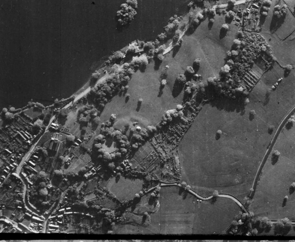
Figure 4: RAF Aerial photograph 1946, Historic England Archive

The possible southern bailey is visible as a raised triangular plateau in the LiDAR data, and its outline appears to correspond with earthworks visible on 1940s aerial photography before later housing development (Fig 3). Although parts of this area have since been affected by terracing, quarrying and modern construction, the alignment of the plateau with the existing earthworks suggests that elements of the larger bailey circuit may still survive. This would place the bailey in close relationship with Sandy Lane, a prominent historic routeway that once connected Ellesmere to the town of Shrewsbury.

This is an important shift in how the monument can be understood. Rather than treating the present scheduled bailey as the whole of the enclosure, the survey establishes a clearer working hypothesis that the medieval castle may have occupied a broader area, with the southern ground forming part of a more substantial bailey deliberately placed over a significant routeway. This gives future research a much firmer starting point.
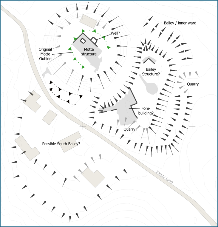
Figure 5: Provisional interpretation of anomalies from the geophysical survey copyright Heneb

What happens next?

The results represent the beginning of a new phase of investigation rather than the final word. Geophysics has shown where significant buried features are likely to survive and has helped refine the questions that now need to be tested. In particular, further work could investigate the substantial structural anomalies on the motte and within the bailey, examine the possible well, and test the proposed southern extension of the bailey.

Any future intrusive investigation would need to be carefully targeted and agreed with Historic England, given the site’s status as a scheduled monument, and the Ellesmere Bowling Club as the green is in regular use throughout the season and quality ground reinstatement would be crucial. The value of the present work is that such investigations can now be planned from a stronger evidence base, focusing on the features most likely to answer key questions about the castle’s form, development and survival.

The survey has demonstrated that Ellesmere Castle retains considerable archaeological potential. It provides a carefully evidenced starting point for the next stage of research into one of Shropshire’s lesser-known but historically significant medieval castles.

Subscribe to our quarterly newsletter

You can read the full report here: Geophysical Survey of Ellesmere Castle, Shropshire | Castle Studies Trust
Ellesmere Castle – Revealing the Secrets of a Major Castle of the Welsh Marches

Ellesmere Castle in Shropshire is a substantial motte and bailey castle in the Welsh Marches that played an important role in the history of the area. However, very little is known about its form and structure with no standing remains above ground, or indeed when it was first constructed.

Starting on Monday 23 March, on behalf of the owners of the motte, Ellesmere Bowling Club, and with the support of owners of the rest of the castle Shropshire Council and funded by the Castle Studies Trust, archaeologists from the heritage organisation Heneb will be undertaking a programme of geophysical survey at the castle to assess the potential for surviving sub‑surface archaeological remains. The methods being used include magnetic gradiometry and electrical resistivity survey.

Subscribe to our quarterly newsletter

Ellesmere motte top, showing size as an shape of possible structure shown by GPR survey

The motte itself is substantial. It is approximately 80m in diameter at its base, 52m across the top and stands about 11m high. A steep-sided ditch, about 20m wide and 3m deep, separates the motte from the bailey to the south east. In 2024, a partial and informal Ground Penetrating Radar GPR survey was carried out, which suggested and indicated a substantial structure, probably indicating a stone structure with the dimensions of 23m x 14m.

Lidar image of Ellesmere Castle including areas of geophysical survey

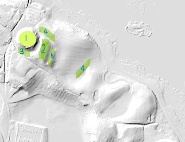
This current survey builds on the work carried out in 2024. It will be covering four areas of this very large castle site. The LiDAR image below shows the four targeted areas for geophysical survey:

  1. Motte: to pinpoint the position of the curtain wall along with any other buildings within.
  2. Bailey: to determine the location and size of the buildings.
  3. Area three, to establish where the outer defensive wall once stood that came down from the top of the motte, and to understand the width and depth of the defensive ditch, along with deciphering the extent of the bailey (No2), part of which had been quarried away sometime in the past.
  4. Earthworks which are believed to be the outer defensive walls, showing what appears to be an entrance in the north east section, and to investigate the furthest easterly earthworks to determine whether there was both an inner and outer bailey.

Subscribe to our quarterly newsletter

The date of construction is unknown: it could have been built as early as the late eleventh century, by marcher lord Roger de Montgomery. The lands were confiscated by the crown following his son Robert de Bellesme’s rebellion. The castle was certainly in existence by 1138. In 1174 Henry II confirmed the manor to Dafydd ab Owain, a north Welsh prince, when he married Henry’s sister Emma in 1174. During the early to middle part of the 13th century the manor of Ellesmere passed in and out of royal control and throughout much of that century there are numerous accounts of building or repair works especially during the reign of Henry III.

Ellesmere Castle bailey with motte in the background, copyright Gary Bick

In 1241 John le Strange was paid forty pounds to build a castle also in the same year twenty one pounds was spent on building two bretasches. In 1256, the King’s house within castle was repaired at a cost of five pounds ten shillings and nine with a further one hundred and sixteen pounds being spent on castle repairs further emphasising the castle’s significance.

In historical terms, perhaps its most well-known claim to fame is that Joan, daughter of King John and wife of Llywelyn ap Iorwerth, was confined to the castle for about a year following her infidelity.

While the survey will not answer questions on its history, it will hopefully supply more details on the castle’s form, and potential targets for future excavation so we can learn more about its history.

Subscribe to our quarterly newsletter

A castle in context: exploring the settlement context of Castle Pulverbatch

Giles Carey project lead for the Castle Pulverbatch survey, funded by the Castle Studies Trust,  presents an overview of the wider settlement context for the motte and bailey at Castle Pulverbatch, central Shropshire.

“It is a truism that medieval castles ‘dominated’ their landscapes. But this apparently simple statement obscures, and indeed misrepresents the many and varied ways in which castles were both embedded in the medieval landscape and contributed to its evolution and character.” (Creighton and Higham, 2004: 5).

Subscribe to our quarterly newsletter

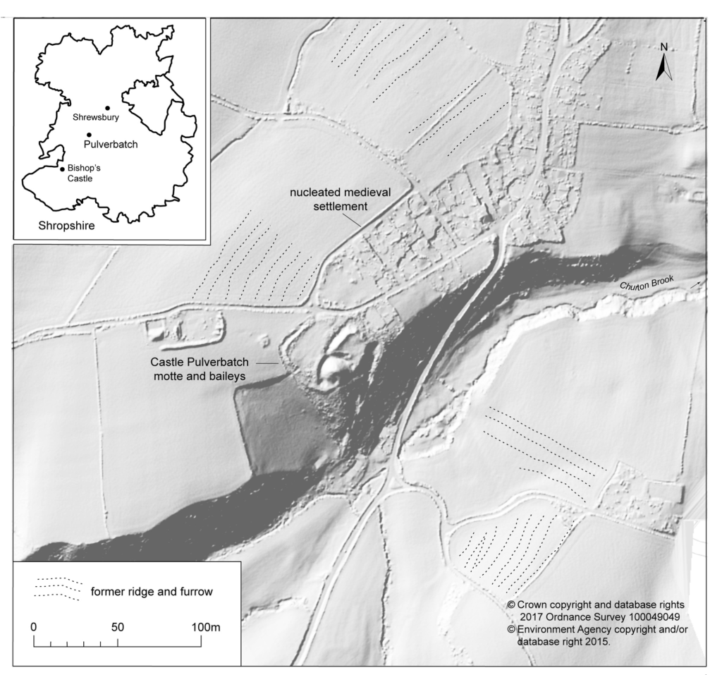
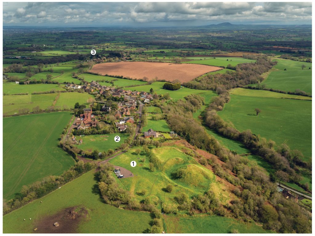
Pulverbatch is a village situated in central Shropshire, about 13km southwest of Shrewsbury on a minor road from Shrewsbury to Wentnor. The modern village is formed of two distinct centres, with a small nucleated settlement around the church (Church Pulverbatch, known as ‘Churcheton’, then Churton since at least the 13th century (Gaydon, 1968: 138)), and Castle Pulverbatch lying c.1km to the SW. One of Shropshire’s best-preserved motte and bailey castles is situated on the edge of a small steep-sided ridge at the southern end of the village (figure 1).

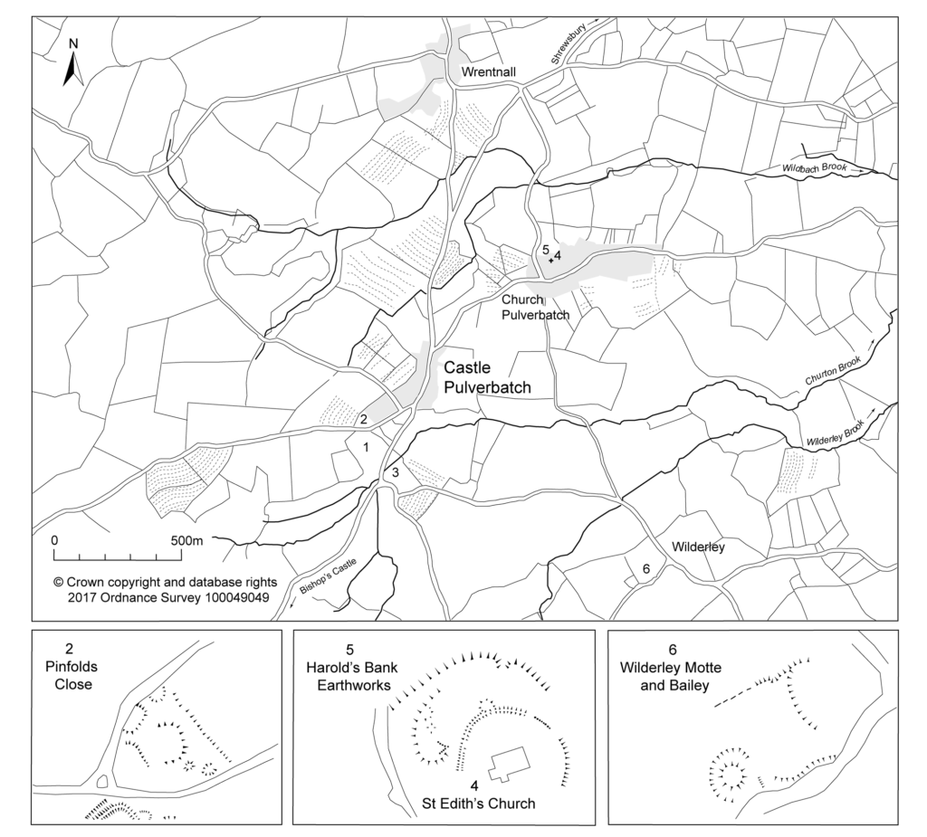
Figure 1. The immediate area around Castle Pulverbatch. Probable medieval ridge and furrow ploughing (plotted after Stillman 1980) is superimposed on a LiDAR image – much of this has been removed by more recent ploughing, though traces can be still seen in the field at the top of the image – just north of the village. LiDAR data collected for the Stiperstones and Corndon Landscape Partnership Scheme. © Giles Carey

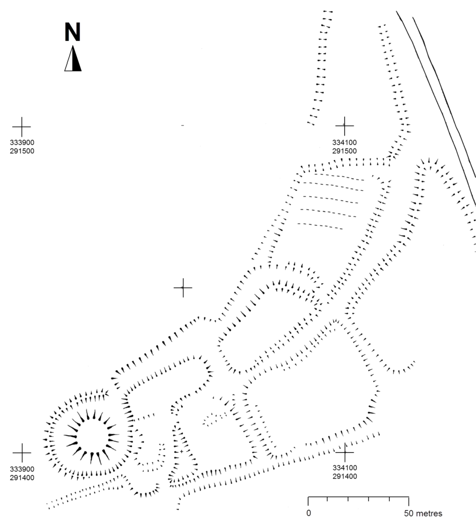
The castle comprises a roughly circular motte, with a base diameter of 35m standing up to 8m high, constructed on the edge of a ridge to make the best use of the natural topography. A substantial ditch 7m wide and 2.6m wide, with a counterscarp bank 4m wide and 0.8m high, separates the castle motte from the flat ground to the west. The inner bailey, situated to the north-east of the motte, is roughly rectangular in plan. It measures 28m north-east to south-west by 30m south-east to north-west. Around its north-west and north-east sides, the bailey is defended by a substantial bank up to 10m wide and 4.2m high on its outside, 1.5m high on its inside. The south-east side of the inner bailey is not defined by a bank but makes strategic use of the natural topography to provide a defendable location. The outer bailey, standing to the west, is, by contrast, defined by much slighter defences. This difference in construction has been suggested as indicating a two-phase construction for the site, with the outer bailey representing the enlargement of a compact and strongly defended initial structure (Stillman, 1980: 3). The outer bailey extends 80m north-south by 40m east-west. A defensive bank up to 6.5m wide and 1.4m high runs along its north-west side, defining a deep hollow-way which runs adjacent to the field boundary in this location.

Figure 1: Castle Pulverbatch in context. 1. Motte and bailey; 2. Possible medieval settlement; 3. Church of St. Edith. © Aerial Cam, 2017.

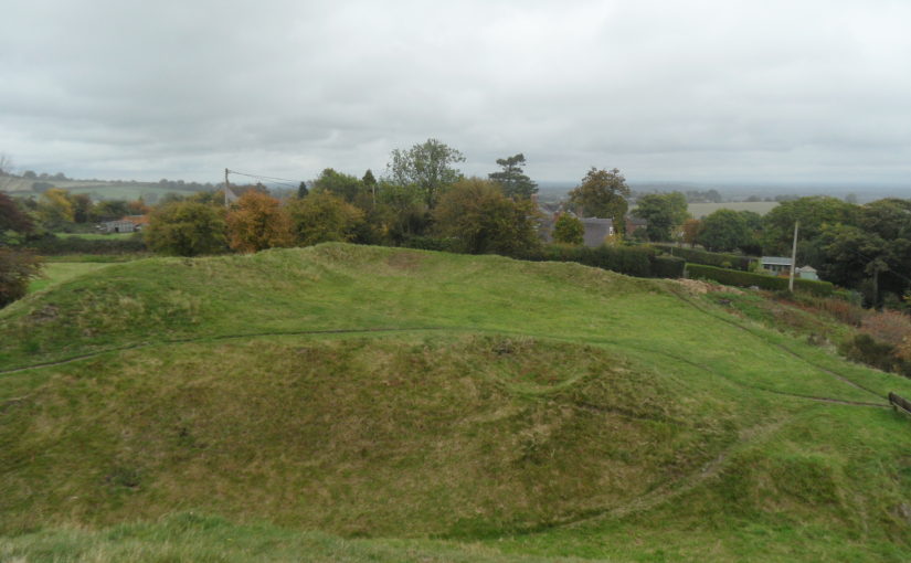
Strategically, the castle occupies a dominant location on the edge of a spur extending south from the village of Castle Pulverbatch. From the top of the motte, views run along the valley of the Churton Brook, and cover the road network (figure 2). It has been suggested that the castle could have provided a control point over “the route from hill country to the Severn valley, perhaps levying a toll on traffic” (Stillman, 1980: 18).

Castle Pulverbatch is typical of rural earthwork castles in Shropshire and the wider Marches. It appears to form an outlier for a concentration of 12 similar motte and baileys in the Vale of Montgomery, from Montgomery in the south-west to Caus in the north-east (Cathcart King and Spurgeon, 1965). These small, rural castles have a number of key characteristics – mottes with a very restricted top, which would have been capable of carrying only a small structure – a ‘blockhouse or pill-box’ as Cathcart King and Spurgeon refer to them, overlooking strategic points on the road network. Pulverbatch certainly meets this criterion – it’s motte ‘dominates’ routeways at the northern approaches to the Long Mynd and the western flank of the entrance to the Stretton Valley.

Figure 3. Key sites mentioned in the text: 1 – Castle Pulverbatch (HER PRN 01051); 2 – Possible tenement plot, Pinfold’s Close and medieval settlement (HER PRN 03703); 3 – mill site (HER PRN 03704); 4 – Church of St Edith, within circular churchyard (HER PRN 33037); 5 – earthwork enclosure (HER PRN 03702); 6 – Motte and bailey at Wilderley Hall (HER PRN 01052). Derived from sketch survey by Nigel Stillman (1980) with additional detail added from LiDAR imagery. © Giles Carey

In 2017-2018, The Castle Studies Trust, and the Shropshire Archaeological and Historical Society provided grant-funding for geophysical surveys on the site, together with a level 2 earthwork survey using photogrammetry (Donaldson and Sabin, 2017; Stanford, 2017; Ashby, 2018). The results of this work were informative, and suggestive of a substantial building, measuring 22m by 18m in the inner bailey. Background research, however, drew attention to the wider landscape. It soon became clear that the story of the castle would only be ever half-complete if one focused on the earthworks and buildings of the inner and the outer bailey. The inter-relationship between the motte and bailey, its associated settlement and the parish church of St. Edith was evidently worthy of further exploration (figure 2).

Castle, settlement and church

Pulverbatch is first mentioned in the Domesday Survey of 1086 when it appears as ‘Polrebec’. The name derives from Old English, a combination of pulfre of unknown meaning and bǣce meaning stream valley (Gelling 1990, 245–7). At Domesday, the manor of Pulverbatch, combining both modern settlements of Church and Castle Pulverbatch, was held by Roger Venator [The Hunter]. Roger Venator was a tenant of Roger de Montgomery, Earl of Shrewsbury. Along with his brother Norman, he was a huntsman for the Earl and was consequently granted land in the Shropshire forests. He also held nearby Wrentnall.

Domesday records Pulverbatch as comprising two hides of land which paid tax, and there was land for five ploughs: two ploughs in the lordship with four slaves, while seven villagers had a further three ploughs between them. There were also two ‘radmans’ [riding men – the lord’s servants] in the manor. There was enough woodland for the fattening of 100 pigs. Before 1066, the manor had been worth £6 in tax; that had dropped to 20s in 1066, but by 1086its value had risen  to 30s (Eyton 1854, 189).

Subscribe to our quarterly newsletter

The evidence suggests that the castle was built towards the end of the 11th century, either by Roger Venator or his son, also called Roger. Castle Pulverbatch is one of eighteen or more earthwork castles in south-west Shropshire that were built by the first Norman lords installed by Roger de Montgomery, himself one of three key lieutenants installed by William the Conqueror following rebellions in the Welsh Marches in the later 1060s. Documentary sources refer to the castle still being occupied in 1205, but there is no trace of a manor-house here in documents of 1292 (Gaydon 1968, 131).

Another motte and bailey lies 1.2km to the south-east, north of Wilderley Hall Farm (Figure 3, site 6), which at Domesday was held by another minor tenant of Roger of Montgomery, Hugh Fitz Turgis (Eyton 1854, 258). Probably, like Castle Pulverbatch, Wilderley was positioned strategically to command a route running northwards from the Long Mynd towards the Severn Valley (Gaydon 1968, 132). Little is known about the  history of Wilderley so establishing any chronological link between the two castle sites remains challenging.

In 1254 Philip Marmion was granted the right to hold a weekly market at Pulverbatch on Mondays, and an annual three-day fair around the day [16th September]of St Edith the Virgin’, to whom the church in Church Pulverbatch was dedicated (Eyton 1858, 197).

At an inquest on the death of Philip Marmionon January 14 1292, his estate at Pulverbatch included a ‘capital messuage [house, yard, outbuildings and land], a carucate of arable land, and two acres of meadow. A Mill realised 30s…’ (Eyton 1858, 199). The latter was presumably on the site indicated by slight earthworks in a field identified on the tithe map as Upper Mill Meadow (Figure 3, site 3).

There is no clear dating evidence concerning settlement at Pulverbatch. The chronological picture is further complicated by the suggested early date for a church at Church Pulverbatch (Figure 3, site 4). The present building is medieval in origin, although it was largely rebuilt in 1853 (Newman and Pevsner 2006, 203–4). (A lovely watercolour of the pre-19th century form of the church is held by Shropshire Archives, and a small version can be accessed via their online catalogue: https://www.shropshirearchives.org.uk/collections/getrecord/CCA_X6001_19_372B_4)

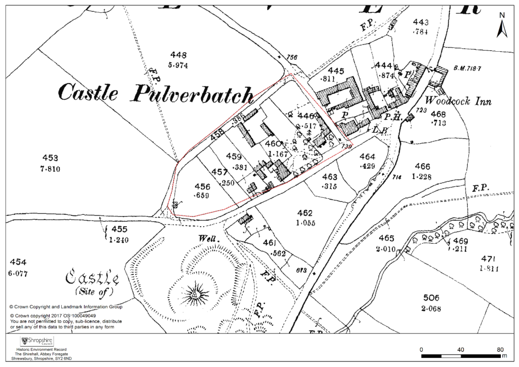
Figure 4 – 2nd edition 1:2500 Ordnance Survey map of 1903, showing suggested extent of settlement to immediate NE of the Castle site.

The church lies within a circular, embanked churchyard, which has been suggested as indicating an early, possibly pre-conquest origin, drawing upon other examples from the Marches (Rowley 1972, 81), although this hypothesis is untested in the county (see Ludlow 2009, 71-76 for discussion of examples from south-west Wales). A number of other circular churchyards are known in Shropshire (Cardeston, Stanton upon Hine Heath, Llanymynech, Loppington and Leighton, inter alia), but the importance of that at Pulverbatch is heightened by the presence of additional earthworks to the north of the churchyard, occupying a high point within the wider landscape (Figure 2, site 5).

A number of authors have speculated about the development of the medieval settlement sited immediately north and west of the castle (figure 4). Little earthwork evidence survives of this settlement, although a slight bank was recorded in the 1980s by Stillman on a triangle of land known as Pinfold’s Close, directly to the north of the castle’s outer bailey. This triangle was suggested as a possible plot division (see Figure 2, site 2) and subsequently recorded as a property/field boundary by Wendy Horton on a site visit in 1991 (Shropshire HER PRN 03703). Sadly, this area has been extensively disturbed since then, and little trace of any earthworks was found during the 2017-2018 survey work.

Higham and Barker see the village ‘growing up around a castle founded in previously open countryside’ (Higham and Barker 1992, 200) while Rowley suggests that its regularity indicates a deliberately planned settlement unit laid out by the lord of the manor in the 12th or 13th century (Rowley 1972, 86). Creighton goes further in identifying the development at Castle Pulverbatch as representing a nucleation point, “a regular settlement” growing up adjacent to the “new seigneurial centre” (Creighton 2002, 203). This would accord well with the manor of Pulverbatch becoming the caput baroniae, or principal manor of the baronry of Pulverbatch by the end of the 12th century (Gaydon 1968, 131). Stillman suggests that the settlement around the castle may have been a fairly speculative endeavour from the lord of the manor that was ultimately unsuccessful, with settlement shifting downhill to the modern settlement at Church Pulverbatch (Stillman 1980, 18). There is no evidence of the settlement at Castle Pulverbatch ever expanding into ‘anything more than a small farming community’ (Gaydon 1968, 132).

This relationship between the development of a settlement, and the development of a castle site has been little explored in the region. Whilst the extensive work at the motte-and-bailey site of Hen Domen in the 1970s revolutionised our understanding of the likely former structural complexity of timber castles in general (Higham and Barker, 1972), there has been little opportunity to further investigate the significant group of motte and bailey castles in the Vale of Montgomery and SW Shropshire, including inter-relations between settlements and castle.

Some of these complexities can be seen at the site of Caus Castle, was subject to a detailed programme of earthwork and geophysical survey in 2016, also funded by the Castle Studies Trust (Fradley and Carey, 2016). Although a castle of quite different status, size and setting to that at Pulverbatch, work here provided evidence of a castle, borough, market (and later fair) in states of flux, and indicated that the fortunes of the castle and the fortunes of the town were not always aligned.

A number of other small, earthwork castles in this part of the march would repay such further study. We might think  the  castle at More, for instance. A motte and bailey castle developed here from an earlier ringwork castle, with its associated earthwork remains of a deserted settlement, with the remains of house plots and toft boundaries (figure 5).

Figure 5 – Hachure plan of More Castle, scale 1:1250. © Shropshire Council Archaeology Service / Hannaford and Sylvester, 2015.

Non-intrusive landscape survey, as funded by the Castle Studies Trust, allows us to place these sites in some context, and allows a glimpse at the bigger seigneurial, tenurial and topographic picture of these earthwork castles.

Subscribe to our quarterly newsletter

Featured image Castle Pulverbatch bailey from motte top.

Bilbliography

Ashby, D., 2018. ‘Castle Pulverbatch, Shropshire: Ground Penetrating Radar Report’, unpublished report, ARCA, University of Winchester.

Carey, G., 2018. Capturing the Castle: recent survey work at Castle Pulverbatch Motte and Bailey, Shropshire, Transactions of the Shropshire Archaeological and Historical Society 93 pp.31-44

Cathcart King, D. and Spurgeon, C., 1965. ‘The Mottes in the Vale of Montgomery’, Archaeologia Cambrensis 114 pp.69–86.

Creighton, O. and Higham, R., 2006. ‘Castle studies and the ‘landscape’ agenda’, Landscape History 26 pp.5–18

Creighton, O. H., 2002. Castles and Landscapes. London: Continuum

Donaldson, K., and Sabin, D., 2017. ‘Castle Pulverbatch Motte and Bailey, Shropshire: earth resistance & magnetometer survey report’, unpublished report, Archaeological Surveys Ltd., report no. J708. Shropshire HER ESA 8253.

Eyton, R., 1854. Antiquities of Shropshire Volume 6. London. John Russell Smith.

Fradley, M. and Carey, G., 2016. ‘Archaeo-topographical survey: Caus Castle, Westbury — a preliminary report’, unpublished report. Shropshire HER ESA 8179.

Gaydon, A. (ed.), 1968. The Victoria History of Shropshire: Volume VIII. London. Oxford University Press.

Gelling, M., 1990. The Place Names of Shropshire. EPNS, Vols. LXII/LXIII (Part One).

Hannaford, H., and Silvester, R., 2015. ‘Desk-based studies of four castles in the Welsh Marches: Castle Pulverbatch, More Castle, Wilmington Castle & Hyssington Castle’, unpublished report, SCAS, report no. 371. Shropshire HER ESA 7514.

Highham, R. and Barker, P., 1992. Timber Castles. Exeter: University of Exeter Press

Ludlow, N., 2009. Identifying Early Medieval Ecclesiastical Sites in South-West Wales In: Edwards, N. (ed.) The Archaeology of the Early Medieval Celtic Churches London: Routledge, pp.61–84.

Pevsner, N. and Newman, J. 2006. Buildings of England: Shropshire. London: Yale.

Rowley, T. 1972. The Shropshire Landscape. London: Hodder and Stoughton.

Stanford, A., 2017. ‘Castle Pulverbatch Processing Report’, unpublished report, Aerial Cam, report no. C-P-01042017.
Shropshire HER ESA 8254.

Stillman, N., 1980. ‘Castle Pulverbatch: a field survey of a motte and bailey earthwork in Shropshire’, unpublished report, University of Birmingham. Shropshire HER ESA 1137.

Thorn, F., and Thorn, C. (eds), 1986. Domesday Book: Shropshire. Chichester