Scott Stull, archaeology lecturer at SUNY Cortland, looks at the results of an interdisciplinary led by Physicist Michael “Bodhi” Rogers, that he took part in looking at the landscape and viewscapes of Trim Castle.
Trim Castle, in County Meath, Ireland, was built starting in 1187 by the De Lacy family as part of the Anglo-Norman conquest of Ireland. After a long history of conflict, disputed ownership, expansion, change, and decay, the castle was finally abandoned in the mid-sixteenth century when it was described as being full of cattle and dung. The medieval landscape around Trim is remarkably well preserved, including the walls of the town, a fourteenth-century bridge over the River Boyne, a variety of religious institutions, and the farmlands, called the Porchfields, which still have their ridge and furrow plough marks.
In 2016 and 2017, Michael “Bodhi” Rogers led a team of students to digitally record Trim Castle and the surrounding landscape. That scanning project was described in Archaeology Ireland (https://www.jstor.org/stable/pdf/26565802.pdf). The results of that project allowed further study and analysis of the landscape, and specifically the viewscape, of Trim Castle. In a three-way interdisciplinary project, Scott Stull (archaeology), Michael “Bodhi” Rogers (physics), and Michael Twomey (medieval literature) looked at Trim Castle and how the views from the castle were carefully constructed as part of the creation of medieval power and authority.
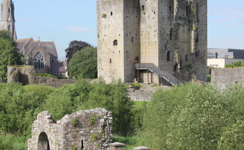
Trim Castle showing the Dublin Gate (foreground) and Keep (background), image credit Michael “Bodhi” Rogers
The starting point for this study, which is a chapter of the upcoming volume, Bailey, Kinsella, Thomas (eds) Architectural Representation in Medieval Textual and Material Culture (Arc Humanities Press, 2022), is the concept of the cultural landscape. The cultural landscape is how people shape a landscape and put meaning on it, to influence perception, behaviour, and patterns of social interaction. It can be practical, such as food production, or it can be tied to belief systems, such as religious sites, places associated with an ethnic or group identity, or associated with structures of power and authority. Castles, while often associated with military activity, embody most of these elements, and as part of the cultural landscape help create beliefs that support those practices and perceptions.
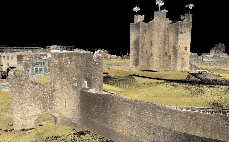
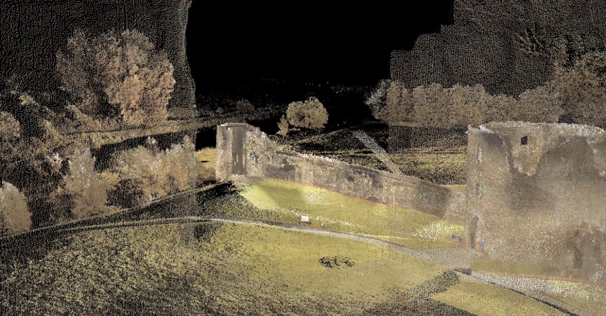
Viewscapes are a specific aspect of a cultural landscape, and in this case are the views from the castle. At Trim, the castle is placed to oversee the town, roads, bridge, farm fields, and religious institutions. There are a variety of ways to identify and record viewscapes, such as with mapping and GIS systems (for example: Lisa Karen McManama-Kearin, The Use of GIS in Determining the Role of Visibility in the Siting of Early Anglo-Norman Castles in Ireland, BAR British Series 575, Oxford: British Archaeological Reports, 2013). Our study, overseen by Bodhi Rogers, used ground-based lidar to make a 3D record of Trim Castle and its surroundings. The result of the recording is effectively a 3D photograph which you can examine from any angle or point in space. This allows us to see from windows which are inaccessible physically, or from spots which have been lost due to decay or collapse over time.
Digital record of Trim Castle showing the view from the Constable’s Tower toward the Dublin Gate and River Boyne, image credit Michael “Bodhi” Rogers.
While a useful modern tool, viewscapes were a fundamental part of the medieval understanding of castles. We see castles used as viewing platforms, as symbolic places of literal and figurative elevation, and as part of medieval romances where the view from the window represents both the desire and distance of a romantic attraction. In many cases, the lady views the desired knight from the castle window, and the knight is inspired by the glimpse of the lady in the window, affirming the ideals of courtly love. Religious allegories have the castle as a tower of morality, and the viewscape is often overlooking humanity in all its faults and mundanities. By looking at medieval literature, we can gain an understanding of the medieval mindset.
Combining the physical context of a castle with the medieval mindset allows us to gain a more complete understanding of medieval life. The nobility used castles as structures of power and created a cultural landscape which made that system of power seem normal and natural. Castles were a central part of everyday life in medieval Europe, and the lived experience of medieval people was shaped by the created landscapes in and around a castle. At Trim, the castle overlooked the social and economic centres of the community, from the Porchfields to the monasteries. The viewscapes from the castle were specifically created to reinforce the position of the De Lacy family and its successors over the lands and cultural landscape in Trim. Trim castle was the dominant element in both the physical and social landscape.
In 2020, the Castle Studies Trust funded Dr Karen Dempsey to undertake an innovative new line of research in castle studies, namely to explore the use of plants in castles in medieval Ireland. In this article, Karen explains what she and her colleague Dr Fiona MacGowan discovered.
Over the course of this Pandemic many people have a newfound or renewed appreciation for the green world that we live in. This might take material form by growing potted plants at home and if fortunate caring for a garden space of your own or somewhat less tangibly, the contemplation of changing seasons in your local park. The (anecdotal) health benefits we might feel from these activities are increasingly underscored by health professionals who assure us of the roles of green spaces in wellbeing. This connection is not a modern phenomenon – plants (and gardens) played a significant role in the diet, healthcare and spirituality of people living as part of castle households.
‘Sowing Seeds of Interdisciplinary Work’, the Castle Studies Trust funded project, showed how relict plants can deliver new insights into everyday life at medieval castles. Relict plants – understood to be the descendants of plants grown, cared for and used by (medieval) people – were identified through botanical surveys at four geographically diverse but culturally similar medieval castles: Adare, Co. Limerick, Castleroche, Co. Louth, Carbury, Co. Kildare and Castlecarra, Co. Mayo (as detailed in my previous blog post). As an initial step in researching relict plants, particular attention was paid to archaeophytes, those plants which arrived in Ireland pre-1500 CE. I believed that these plants may have participated in the various colonisation processes of the twelfth century. Their introduction could be linked to new gardening and other health practices especially those related to novel plant medicines which were emerging across Europe at this time but were perhaps previously unknown in Ireland.
Relict Plant Findings
Botanical surveys began during mid-2020 in the very wet months of June and July after a hot May.
Next site on our Relict Plants project @CastleStudies is Castle Carra Co.Mayo. Built by Adam de Staunton c. 1240. Castle with hall and chamber, with the vill, parish church and abbey c. 1km east. pic.twitter.com/yJISGh7DiL
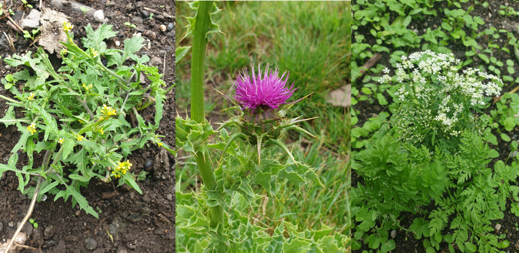
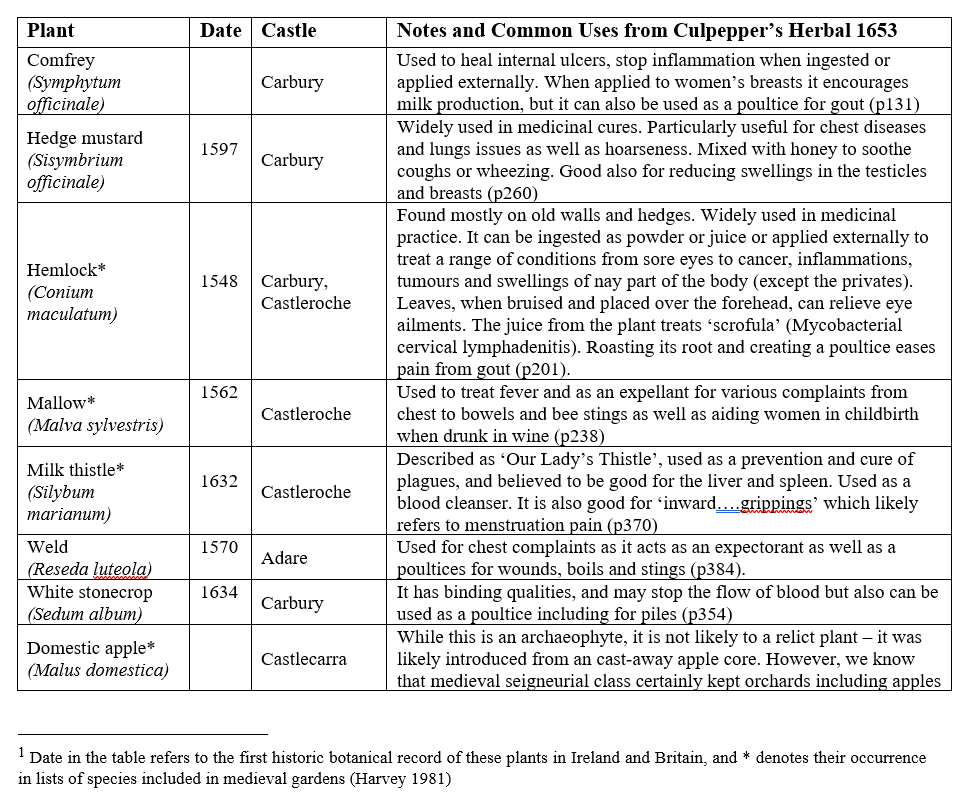
Over the course of the survey eight archaeophytes were revealed (Table 1) as well as a range of rare and common native plants. You can read Dr MacGowan’s botanical report here. These findings are significant: four of the eight plants were historically recorded as present in medieval gardens. The plants – comfrey, mallow, milk thistle and hedge mustard – are widely recognised as having medicinal properties (Fig 1). They feature in medieval recipes, continued as part of the tradition of plant medicine captured in Culpepper’s Herbal of 1653 and some, like milk thistle, remain in use today (see Table 1).
Figure 1 Milk thistle at Castleroche; Hedge mustard and Hemlock (Conium maculatum) at Carbury; (pictures by Dr MacGowan)
Table 1 List of Archaeophytes and neophytes at four selected castles in Ireland[1]
Figure 2 Castleroche, Co. Louth, sited for maximum spectacle across a locally significant elevation at the foothills of the Mourne Mountains
Relict Plants in their Castle Contexts
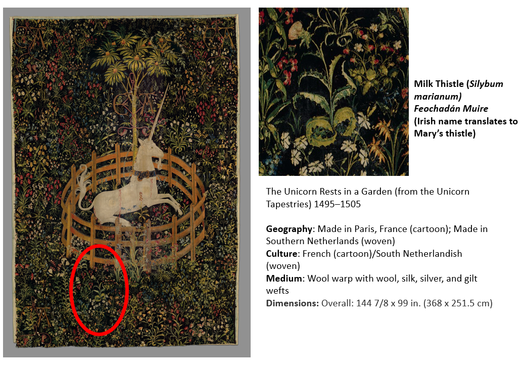
Castleroche was the first site surveyed for our fieldwork. It is spectacularly situated on a locally significant rocky outcrop, framed to the north by the foothills of the Mourne Mountains (Fig 2). The castle has been long understood as a defensive site, believed to have been positioned as authoritative infrastructure to exercise territorial control. Its’ patron, Roesia de Verdun (d.1247) is renowned as the only historically attested woman to have founded a castle in thirteenth-century Ireland This castle while now in ruins was once a busy place with an associated village replete with a weekly market and annual fair. I considered this site to have great potential for relict plants given that historic sources noted the presence of ‘gardinia’ (gardens associated with castles) coupled with the high-status of its’ patron who had a considerable number of estates across England and France. These connections must have given her and her staff access to, and knowledge of, different cultural traditions including gardening and medicinal practices. We were delighted to identify three archaeophytes: Hemlock (Conium maculatum), Mallow (Malva sylvestris) and Milk thistle (Silybum marianum). Milk thistle is a particularly important identification, it is very rare in Ireland and Britain. For medieval people, it was culturally and symbolically tied to the Virgin Mary as well as understandings of fertility and motherhood (Fig 3). This allows us to reconsider the idea of Castleroche only as a frontier site; perhaps there was a diverse resident population for much longer than previously understood. Their health concerns may be represented by the continued occurrence of these plants. Exploring the botanical legacy of Castleroche adds further layers to the story of this complex site.
Figure 3 The Unicorn Rests in a Garden (from the Unicorn Tapestries) 1495–1505. https://www.metmuseum.org/art/collection/search/70007568Figure 4 Carbury, Co. Kildare: a multiperiod castle complex comprises a motte, an early masonry focal building with later additions including an Elizabethan extension crowned with multisided cut stone chimneys
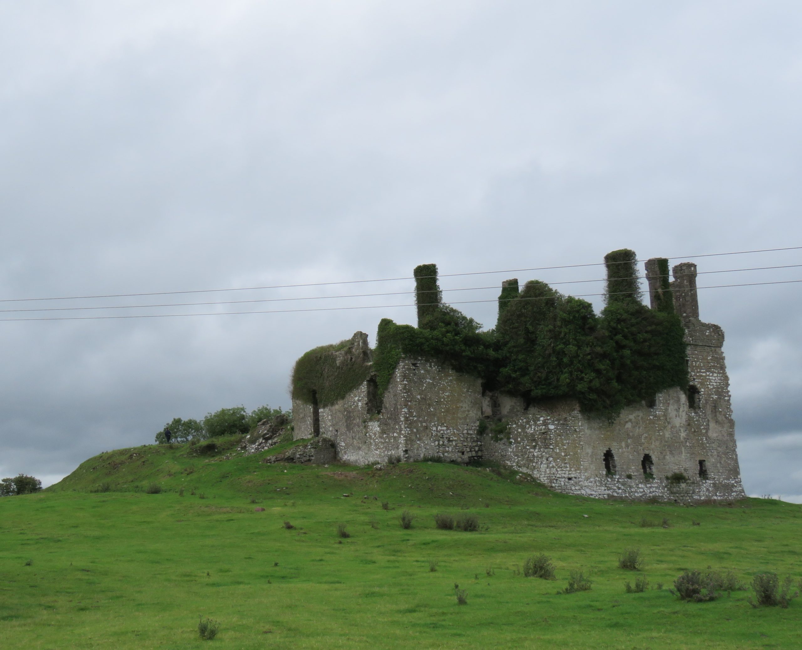
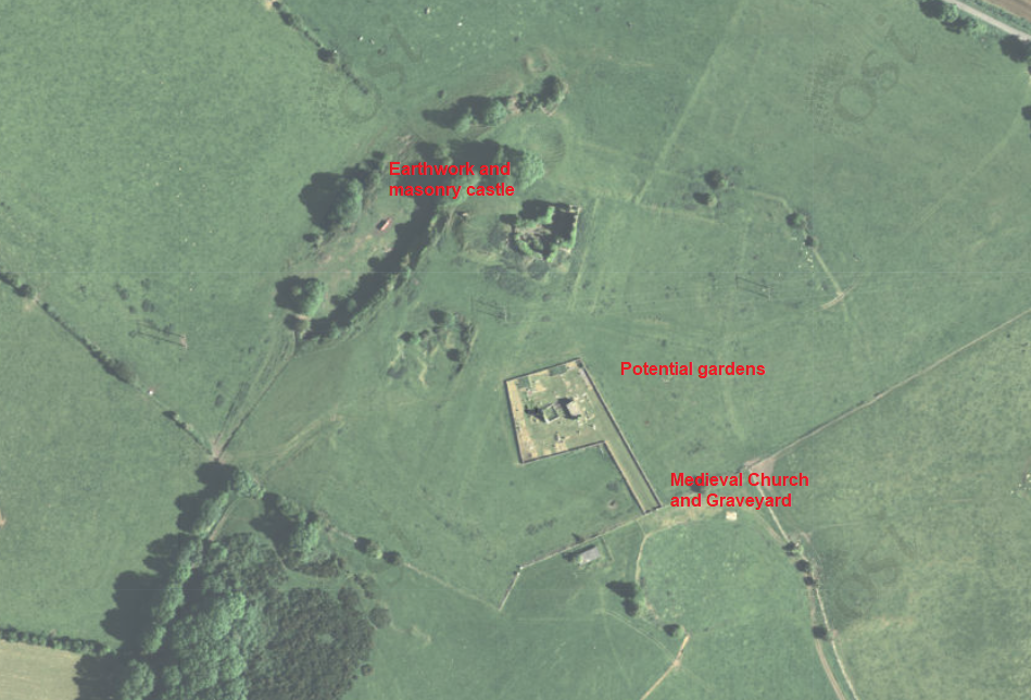
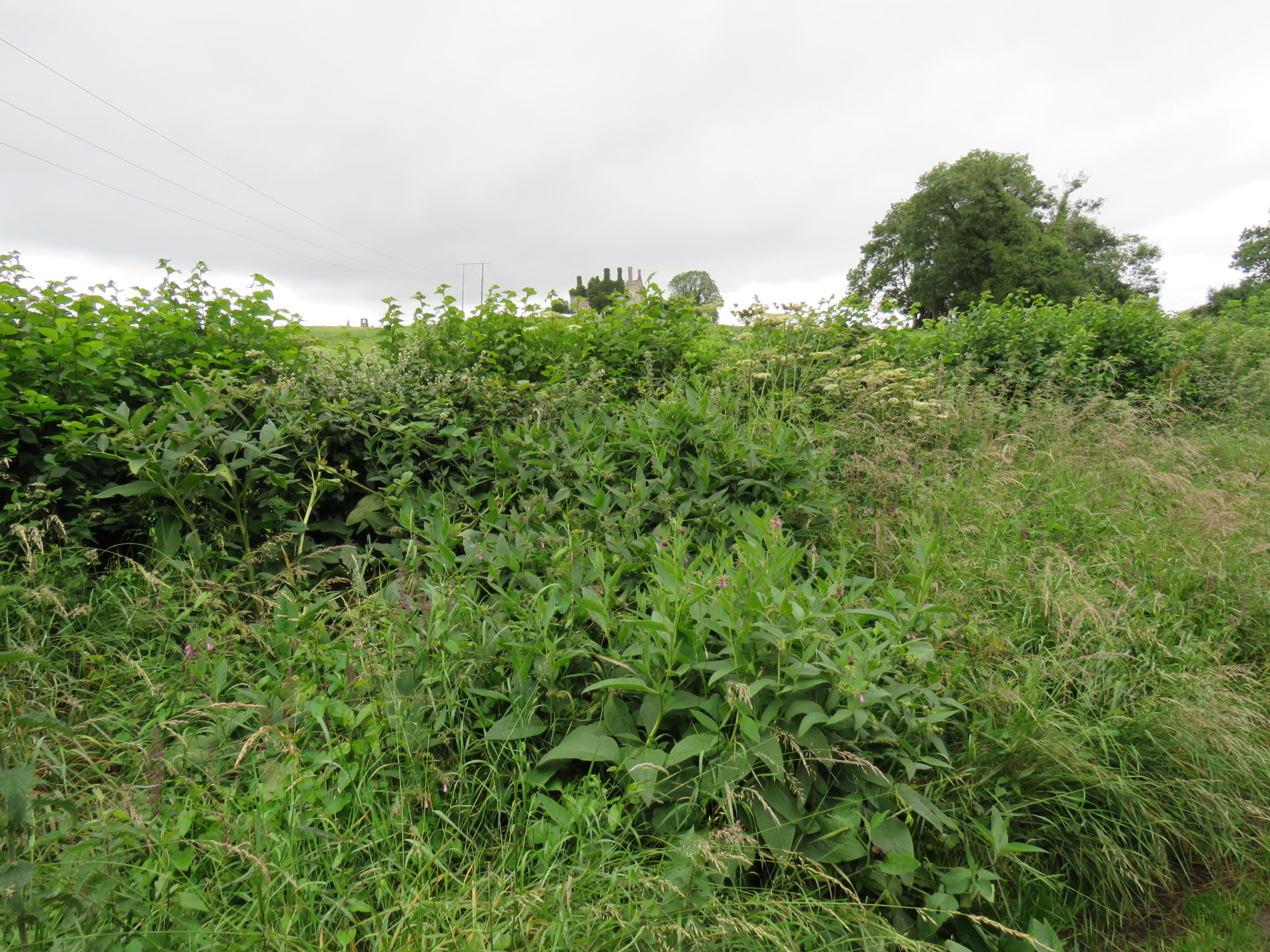
A less well-known castle but equally deserving of attention is the medieval settlement at Carbury (Fig 4). This multiperiod complex comprises an earthwork castle, a twelfth or very early thirteenth-century masonry castle with later additions including an Elizabethan extension and related gardens (Fig 5). Carbury is entangled with generations of nobles. It acted as a central node in shifting political allegiances and dynastic disputes within the territory of Leinster. The longevity in occupation of Carbury is interesting, it attests – at least in part – to its suitability as a residence. Is this reflected in the immediate castle landscape? Is there a possibility that the early-modern gardens here overlay medieval predecessors? Four archaeophytes were found at Carbury: Hemlock, Comfrey (Symphytum officinale), Hedge mustard (Sisymbrium officinale) and White stonecrop (Sedum album), three of which were adjacent to or within the masonry castle and the fourth – Comfrey – which was found within the hedgerow that forms the historically significant boundary to the castle landscape (Fig 6). These plants are not uncommon, but perhaps their relative ubiquity is reflected in their suitability for use within different plant medicine traditions. Comfrey is particularly notable, known as knitbone, it was widely used as a healing poultice for broken bones throughout medieval medical texts. Pharmacologically, this plant contains allantoin, which promotes the creation of new cells and healing of connective tissue. Relict plant studies at Carbury allows us to reflect on how this place was a home to many different generations of people who participated in caring roles (for plants and people) whilst also being a locus for political tensions.
Figure 5 Aerial Imaging of Carbury Castle with evidence for potential gardens surrounding the castle.Figure 6 Comfrey (Symphytum officinale) and Hedge woundwort (Stachys sylvatica) noted among other medicinal plants in hedgerow with Carbury Castle in background
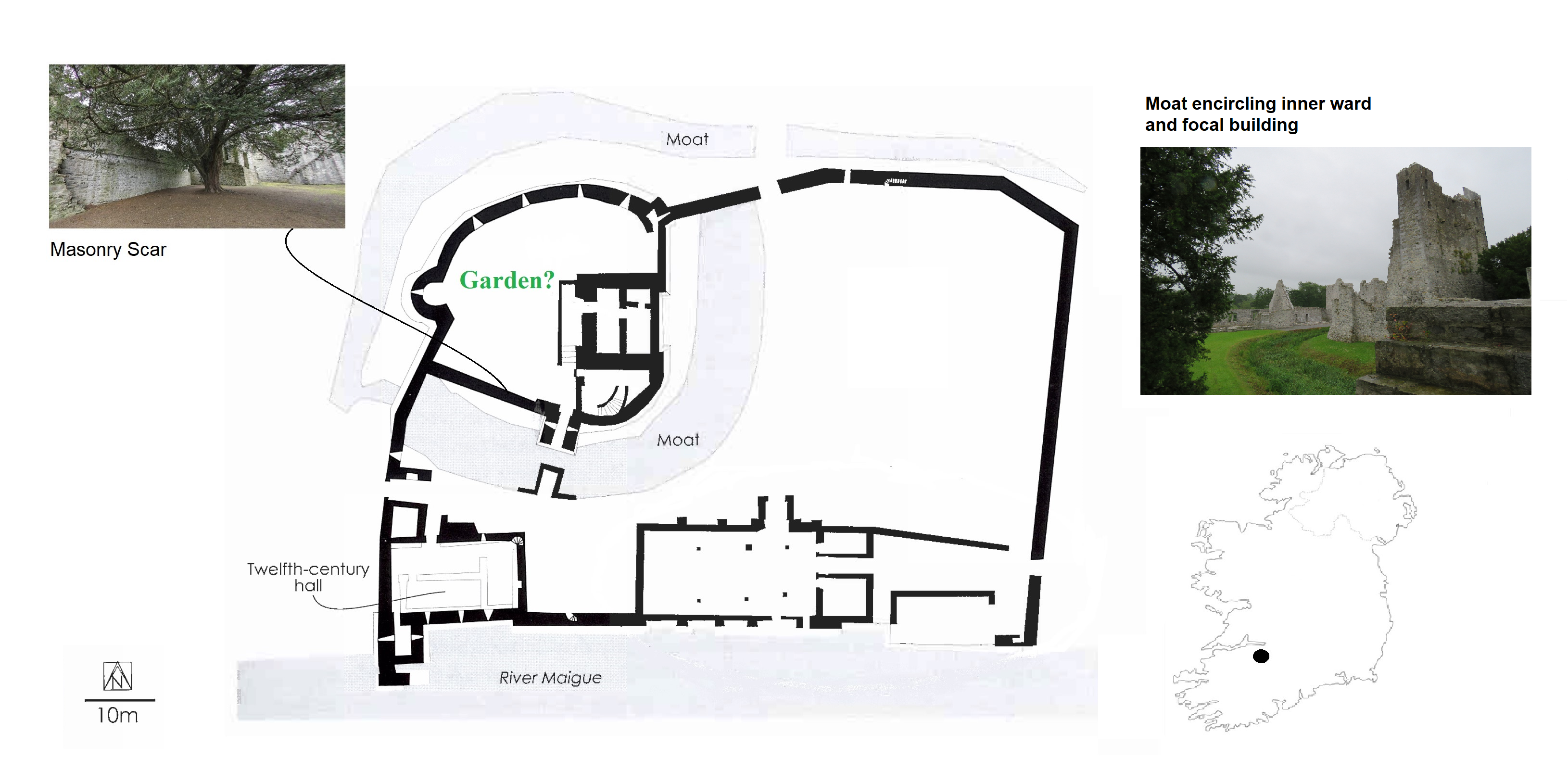
With these exciting discoveries at both Castleroche and Carbury, we were very hopeful that the survey at Adare Castle would be equally rewarding. Adare was an important castle as the caput of the Geraldine family. Unlike the other sites, it has been subject to major study including detailed historical and archaeological investigation. Adare Castle was constructed on a pre-Norman power centre from which the castle emerged as a large D-shaped earthwork with a surrounding large ditch and river-fed moat (Fig 7). This later formed the inner ward, which was further enclosed by an external wall to the north-west with a single mural tower and a gatehouse to the south. The outer court is enclosed by masonry walling which is augmented by a ditch to the north and west. At Adare, the grounds are intensely managed, with manicured lawns and ongoing pesticide use (Fig 8). Unfortunately, this was particularly pronounced in the inner ward, the area I have suggested was likely to have contained an enclosed garden. Disappointingly, only one archaeophyte was identified: Weld (Reseda luteola). This dyeplant was predominantly used to give a bright colourfast yellow but also used medicinally to treat chest complaints. A number of neophytes – those plants whose introduction post-dates 1500 CE – were found in the associated areas surrounding the castle as detailed by Dr MacGowan. Species such as Himalayan pheasant berry (Leycesteria formosa) were identified, indicating that relict plants studies can also illuminate the afterlife of the castle when it played a role as a romantic ruin in the eighteenth-century landscape of Adare Manor. This shows the potential for relict plants studies to add layers to castles stories across their life histories.
Figure 7 Plan of Adare Castle with possible garden (after Dempsey 2021 and O’Keeffe 2015)Figure 8 Adare Castle, inner ward subject to extensive pesticide use
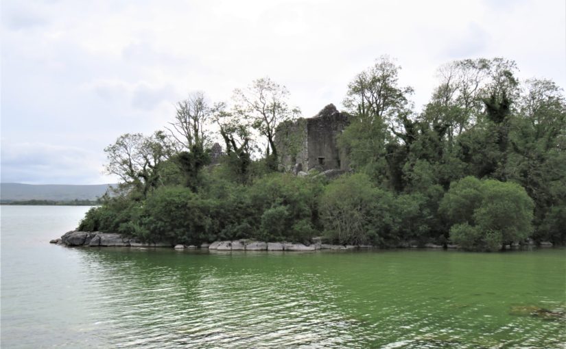
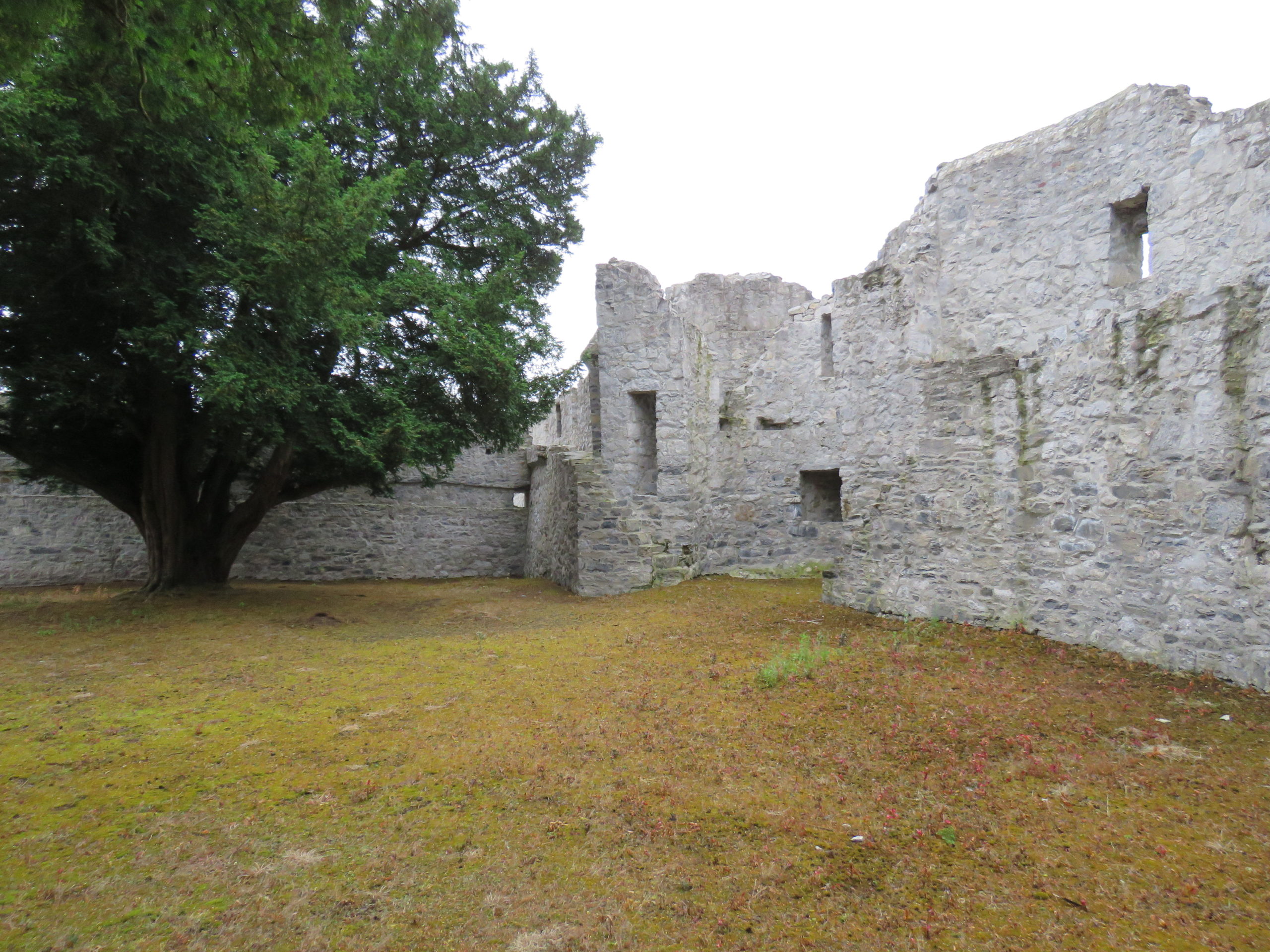
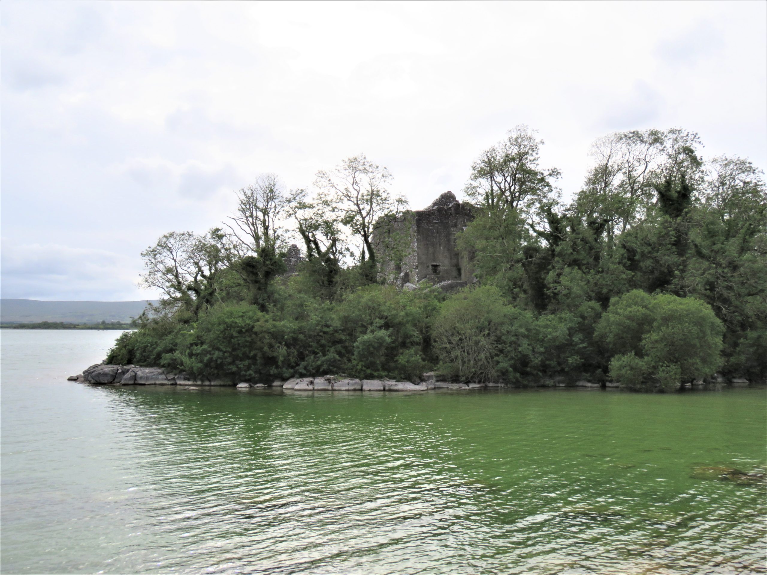
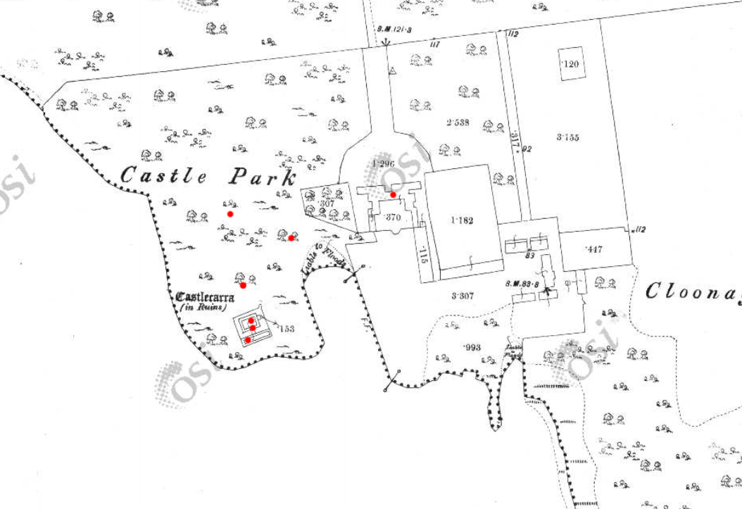
The final site, Castlecarra, falls lower down the social hierarchy of medieval Ireland than the other three castles but it was still an important baronial residence (Fig 9). It is situated on the eastern shore of Lough Carra. The castle now comprises a large three-storey focal building set within a very compact enclosure which is a later, potentially fifteenth-century addition. The castle was constructed as one part of the c. 1236 Anglo-Norman territorial expansion into Connacht. This site, like the others, has a long history of occupation. An early-modern (sixteenth-century?) house was constructed c. 125m NE of the castle, and the surrounding landscape appears to have been remodelled to suit a new tradition of landscape gardening which included a ha-ha and tree-lined avenue of Hornbeams (Carpinus betulus) (Fig 10). Archaeophytes were not recorded at Castlecarra but numerous native species as well as neophytes were present. This absence is remarkable but perhaps native plants at Castlecarra served the castle household needs. For example, Purging buckthorn (Rhamnus catharticus) was identified. This plant is native but rare in Ireland, and it was used medicinally as a purgative, as the name suggests. The botanical profile of Castlecarra leads to further questions around the transmission and sharing of medicinal and plant knowledge.
Figure 9: Castlecarra, Co. Mayo on shore of Lough CarraFigure 10 Castlecarra, Co. Mayo: a multiperiod site with medieval castle that forms part of the landscape of an early modern (c. later 16th / early 17th house). Ordnance Survey Map 1925, Castlecarra to lower left and historic home including outbuildings and gardens centrally placed. https://maps.archaeology.ie/HistoricEnvironment/
Research, Heritage Futures and Reflection
One of this project’s aims was to test and refine the methodologies of relict plant studies for medieval castles. In Ireland there are currently 96 species recorded as archaeophytes (but with no established dates of introduction). Despite the findings of some notable plants, the overall numbers of archaeophytes at the castle sites in ‘Sowing Seeds’ seemed low. Of course, our findings may have been constrained by single survey days, unseasonal weather as well as conservation and management issues – both present-day and historic. Future work is necessary. It is important that sites have the benefit of multiple visits across a wider seasonal survey period. Nevertheless, the baseline botanical surveys of this project will be of use for future research within and outside of castle studies. It has also revealed the need for a detailed survey of archaeobotanical evidence from excavations in Ireland to establish as far as possible exact introduction dates for particular plants.
Including a wider range of plants and castles over a longer time span would provide comparative material with a greater capacity to capture change over time. Neophytes were noted in the botanical surveys but not part of the research agenda for ‘Sowing Seeds’. Their occurrence at castle sites may be revealing of expanding connections with sixteenth-century colonising and trading practices beyond Europe. Later medieval towerhouses are of particular interest as they are often situated within less managed and therefore within potentially better-preserved landscapes. But equally, native plants should also be included. For example, self-heal (prunella vulgaris) and pellitory-of-the-wall (Parietaria judaica) occur widely and were both used as medicinally. It would be of great interest to compare and contrast different plants at castles whether native, anciently introduced or more recent. Consideration too could be given to the afterlives of medieval castles as romantic ruins as indicated at Castlecarra and Adare. This would develop a wider appreciation of the long lives of medieval castles that continue in dialogue with contemporary communities as heritage today. Relict plant studies enable castle studies to participate in emerging conversation around green heritage and climate change.
‘Sowing Seeds’ was a novel project – both conceptually and methodologically – I wanted to find a way to explore potential ‘green identities’ of castle households. Accessing the relationships medieval people may have had with their environments (as we might term it today) offers a different way of telling stories about the medieval past whose narratives are often caught into concerns of power, authority or control. By including botanical surveys of relict plants in castle landscapes, we have expanded further the multidisciplinary approach of castles studies. We can show how stories of castles are richly textured: populated by many people and plants over the course of their lives and beyond into their afterlives as romantic ruins and archaeological monuments. Doing this for the first time meant engaging with new material and unfamiliar sources from archaeology, history, and medical knowledge to heritage and folklore. This wide-reaching research methodology is a core strength of this project. It enables a dialogue between different disciplines that are traditionally separate or rarely integrated. These findings are a beginning: they encourage new avenues of future research on castles households relating to human-plant relations, plant medicine and related concepts of care. The results also invite conversations with heritage agencies regarding site management and conservation practices of both biodiversity and past vegetation. Rather than offering conclusive findings, we have revealed tantalising hints and a vast array of potential new avenues in which to take this research.
This research was generously funded by the Castle Studies Trust. Their support enabled new ideas to be explored. As an early career researcher being awarded a grant to undertake (potentially) interpretatively risky work is a wonderful opportunity.
Helpful commentary and feedback was received from two assessors whose insights improved this report.
Thanks to Dr Fiona MacGowan for participating in this research project and carrying-out the botanical surveys at the selected sites.
Thanks to the landowners of Castleroche, Castlecarra and Carbury, and the Office of Public Work who manage Adare, for access to the sites for this project.
[1] Dates in the table refer to the first historic botanical record of these plants in Ireland and Britain, and * denotes their occurrence in lists of species included in medieval gardens (Harvey 1981)
Dr Sarah Kerr of Trinity College Dublin discusses the ongoing project to look at the impact of climate change on castles with a focus on the ones in West Cork, as they are battered by Atlantic storms.
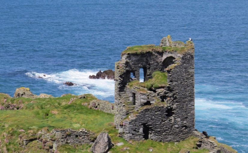
Over the past two years, two small grants (Research Incentive Scheme, Trinity College Dublin, Ireland; and Higher Education Innovation Fund, UK) has funded research into the impact of climate change on built heritages, and the identification of those most vulnerable, particularly in West Cork, in the south-west of Ireland. Dún an Óir is one such castle at risk, on the edge of Ireland, on the brink of the West Cork cliffs and at the mercy of the increasingly frequent Atlantic storms and high winds.
Dún an Óir is a castle at risk, on the edge of Ireland, on the brink of the West Cork cliffs and at the mercy of the increasingly frequent Atlantic storms and high winds. Dún an Óir is an Irish tower house, a type of stone-built castle, smaller than the sprawling castles built by the Anglo-Normans, such as Trim, County Meath and, indeed, serving a different purpose. The relative small size of tower houses placed their construction within the financial reach of lords, emerging gentry and merchants in both rural and urban areas. Tower house construction commenced on the island of Ireland (Ireland hereafter) in the mid-fourteenth century and flourished in the fifteenth and sixteenth, construction ceasing by 1650. Their abundance led Terry Barry to state that Ireland was ‘the most castellated country in Europe in the late middle ages’ (Barry 2008, 129) or at least ‘one of the most castellated parts’ of the Irish and British Isles (Cairns 1987, 31; O’Connor 1998, 25). If so, then Munster in the south-west of Ireland was a focal point of this activity. The West Cork area in the south-western extent of Munster contains 47-known tower houses, many concentrated along the jagged and island-dotted Atlantic coast. The West Cork tower houses are of particular interest as they are the only castle type remaining in the region; plus, contemporary written evidence allows the majority to be ascribed to a certain clan.
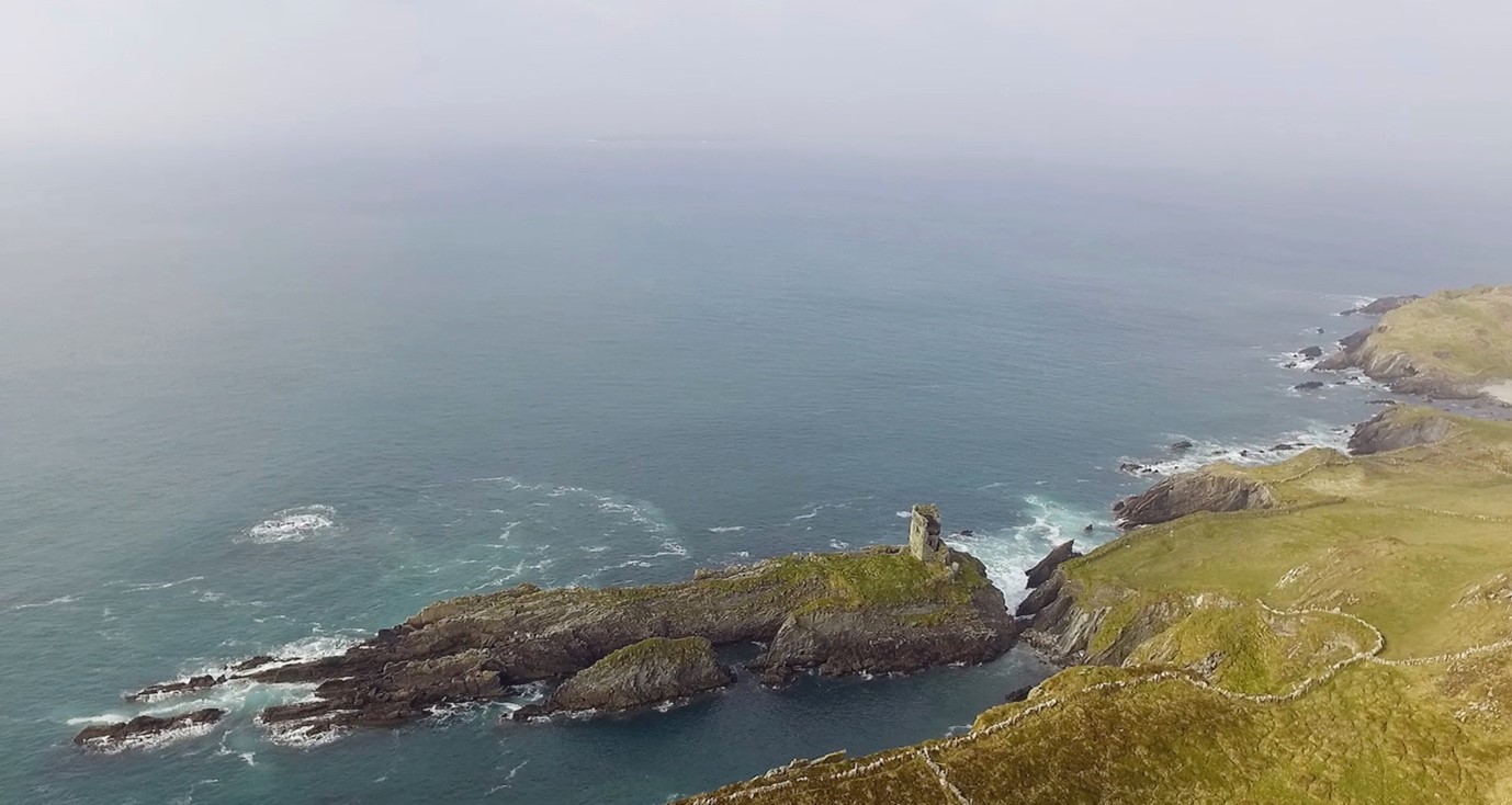
Dún an Óir (Doonanore when anglicised) is located on the island Oileán Chléire (Clear Island), approximately 13km from the Irish mainland. It was built by the O’Driscoll clan in the mid-sixteenth on a coastal promontory (Figure 1). Located on the coast, along with several other known O’Driscoll tower houses, its occupants could oversee the movement of goods through Roaringwater Bay as well as charge passing vessels for anchorage, victualing and exploitation of the waters (Figure1).
This once strategic position is Dún an Óir’s Achilles heel. The building and its immediate landscape are precarious, unconsolidated and unprotected (Figure 1). Exposed on a partially collapsed promontory, its long-term survival is unlikely and our time to understand it short.
Figure 1: Photograph looking north across Roaringwater Bay towards the Atlantic showing Dún an Óir on a rocky promontory.
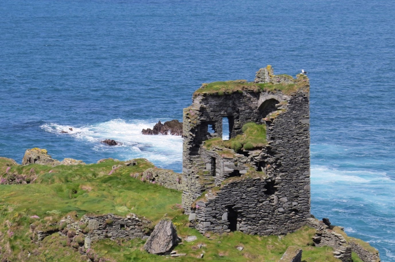
Dún an Óir comprised four-storeys rising from a rectangular ground-plan. Access was through the south wall, although the east wall faced the neck of the promontory (where it connected to the remainder of the island). Much of the south wall has collapsed yet a garderobe tower remains to the east of the door (Figure 2). Above the doorway a mural staircase (built within the thickness of the wall) can be seen leading to at least the first and second floors. There is a vaulted ceiling between the second and third floors in the form of three pointed arches separated from one another by overlapping slabs.
Figure 2: Dún an Óir tower house, from the southeast, showing the mural staircase extending upwards along the south wall (with thanks to Finola Finlay and Robert Harris for the photograph).
A significant and surviving feature of Dún an Óir is its bawn (curtain wall): a stone wall which in this case abuts the tower house (rather than surrounding it) and stretches west to enclose the remainder of the promontory (Figure 3). Vicky McAlister’s recent book on tower houses indicates that the survival rate of bawns is low compared to the tower houses themselves (McAlister 2019, 22), recalling earlier suggestions that the current 1 in 5 survival rate may be representative of their former inclusion. Dún an Óir is a relatively rare example of preserved ancillary buildings within the bawn. Although they remain only as overgrown footings, there appears to be a kitchen with oven, and two more apparently feature-less buildings that appear to be contemporaneous with the bawn wall (Figure 3).
Figure 3: A simple plan of Dún an Oir tower house, bawn, and ancilliary buildings. The proximity tit he promontory edge is clear.
Dún an Oir’s bawn reaches to the edge of promontory, almost certainly to be further damaged or lost in this lifetime. With this seemingly fixed future, the onus shifts to the researching community in the present to document what we can: this is discussed further in a recent paper on the castle (Kerr 2019). The erosion to the promontory renders further buildings survey, as well as geophysical survey or excavation, no longer safe. Therefore, the next steps of fieldwork may include airborne LiDAR. Greater exploitation of innovative surveying methods may overcome the difficulties posed by the physical landscape and allow the tower house, bawn and ancillary buildings to be understood to a greater depth before the inevitable happens.
Barry, T. 2008. The study of medieval Irish castle: a bibliographic survey. Proceedings of the Royal Irish Academy: Archaeology, Culture, History, Literature 108(C), 115–36.
Cairns, C. 1987. Irish tower houses: a Co. Tipperary case study, Group for the Study of Irish Historic Settlement.
Kerr, S. 2019. Reconnecting Cultural Landscapes: Dún an Óir, West Cork, Ireland, Landscapes, 20:2, 160-177, DOI: 10.1080/14662035.2020.1861725
McAlister, V. 2019. The Irish tower house, Manchester University Press.
O’Conor, K. 1998. The archaeology of medieval rural Settlement in Ireland, Discovery Programme Monographs.