Project lead, Steve Parry, looks at what he and the team from MoLA and the Higham Ferrers Archaeology and Research Society hope to achieve during their geophysical survey of the once royal castle of Higham Ferrers starting on Monday 15 July 2024.
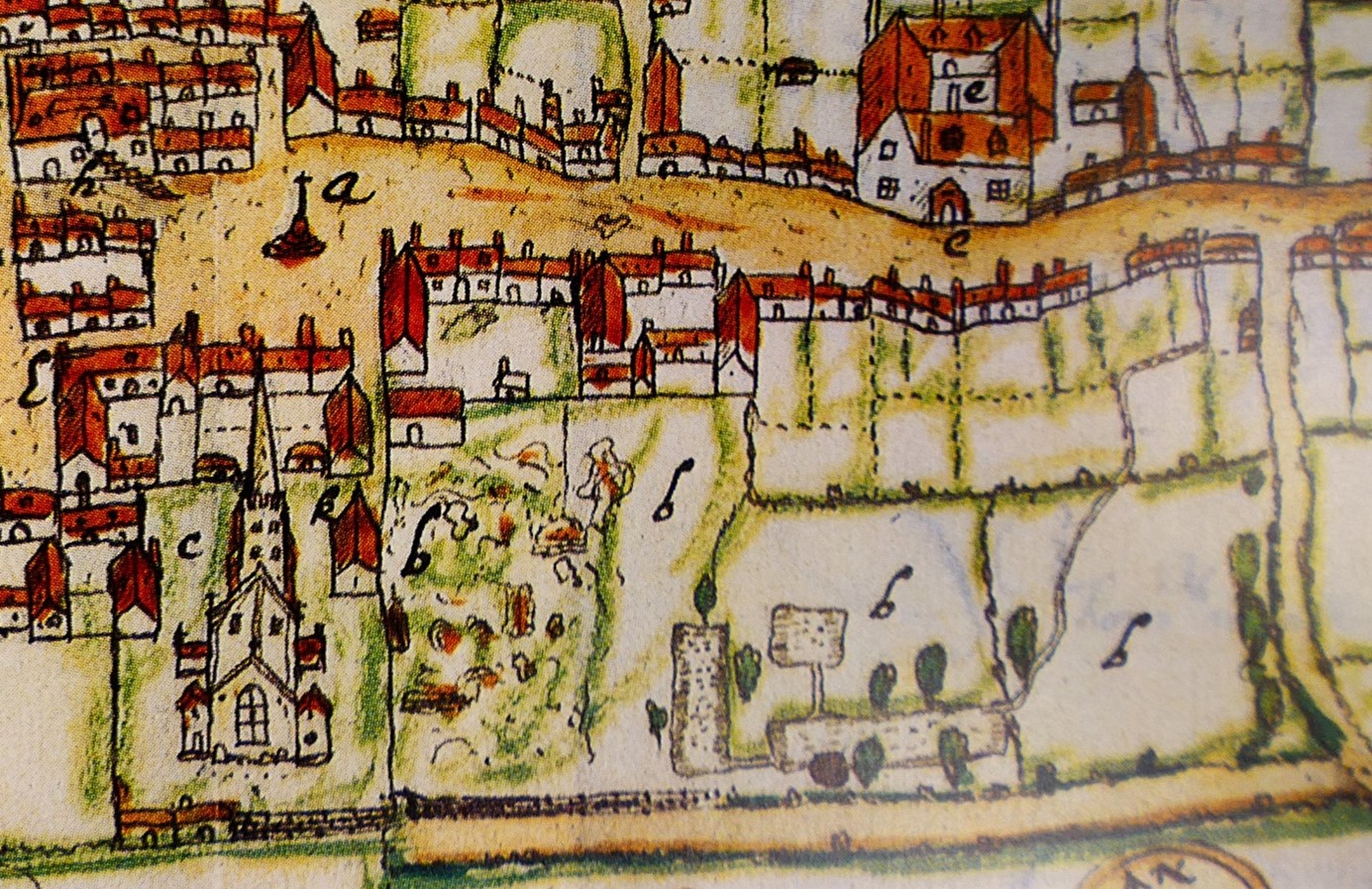
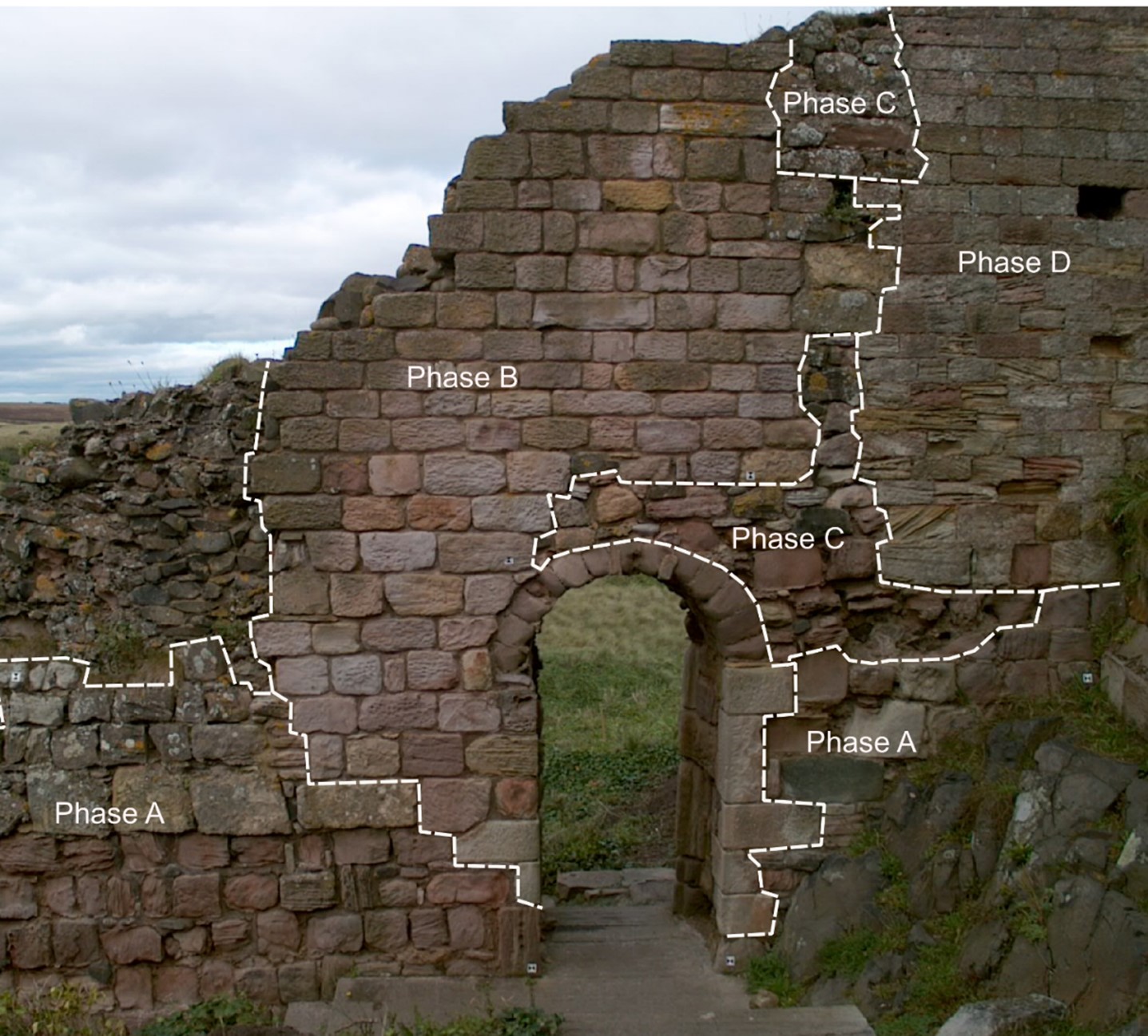
Walking through the streets of Higham Ferrers you’d be forgiven for thinking that you are looking at a pretty but provincial town. However, documentary records reveal that Higham Ferrers once played a role on the national stage. During the Middle Ages it had a substantial stone-built castle which served as the headquarters of the extensive Northamptonshire landholdings of the Duchy of Lancaster and from 1399, became a possession of the Crown. This castle, which was also the manor, would have been the focal point of the medieval town along with other fine nearby buildings including the Church of St Mary, the School House, the Bede House or hospital and the College founded by Henry Chichele, Archbishop of Canterbury before 1425. While these other buildings have survived to the present day the castle fell into disuse and was demolished in the early sixteenth century, with Henry VIII granting building materials from the site for the rebuilding of Kimbolton Castle. John Norden’s map of 1591 shows the site of the castle (‘b’) as broken masonry and uneven ground adjacent to the church, and all that now remains are a ruined dovecote, fishponds, and rabbit warren.
A detail of John Norden’s Map of Higham Ferrers 1591
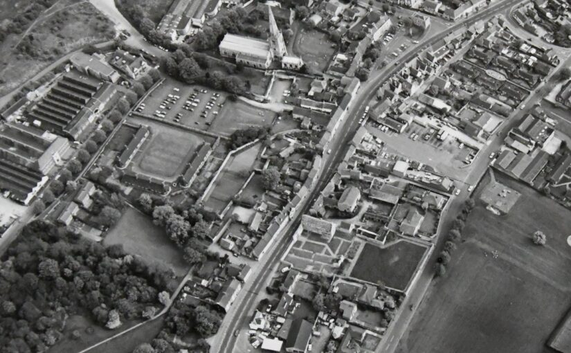
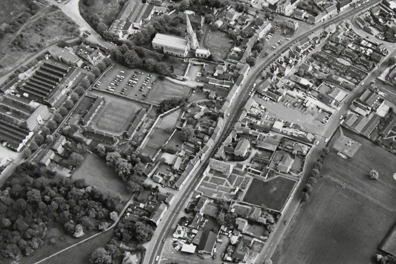
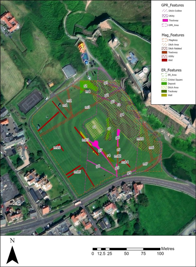
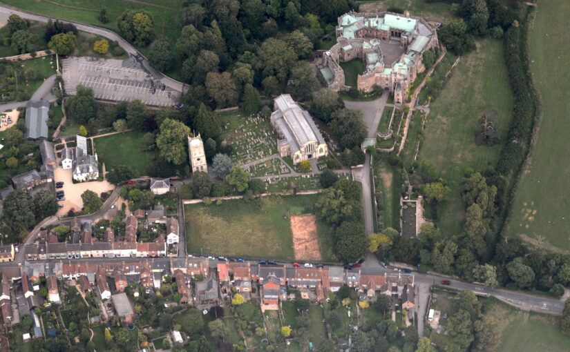
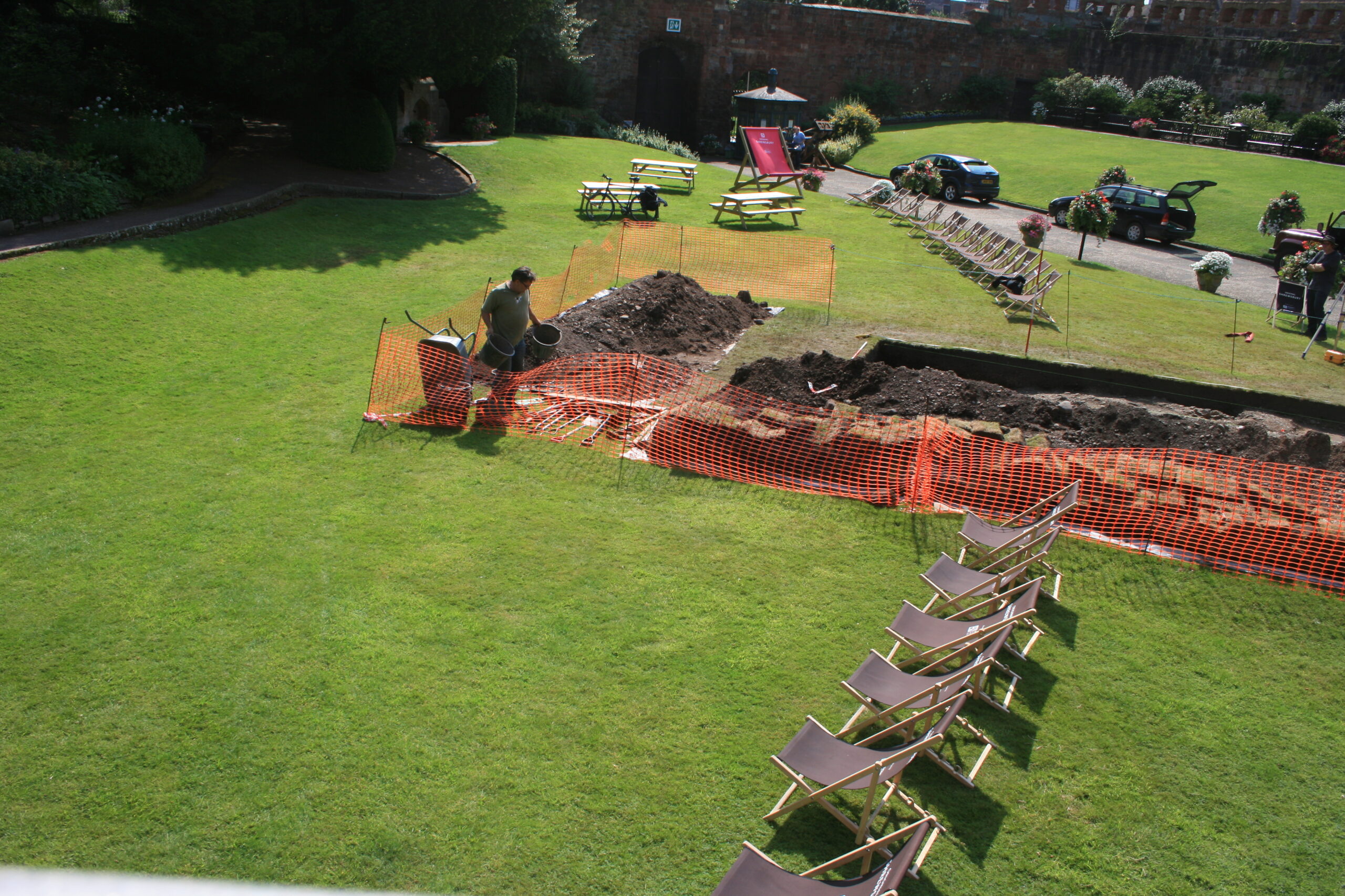
Thanks to a generous grant from the Castle Studies Trust, Museum of London Archaeology (MOLA), will work with Finham Heritage and members of the Higham Ferrers Archaeology and Research Society (HiFARS) to reveal Higham Ferrers’ royal connections through a series of geophysical surveys. We will use a magnetometer to identify any substantial ditches around the castle, as well as the buried remains of internal features such as robbed-out walls, hearths, and pits. Alongside this, the team will use ground penetrating radar to locate the principal buildings of the castle confirming (or denying!) what our documentary sources tell us – that this substantial medieval building included a hall, chapel, tower house, King’s and Queen’s Chambers, not forgetting three substantial gates. Finally, a resistivity survey will be undertaken, with the particular support of HiFARS members, to provide further detailed information on any buried wall foundations or other structural remains. The surveys will be undertaken in the various plots shown in this photograph from the 1980s extending from the church (top centre) to the small wood (bottom left-hand corner).
Aerial photograph of Higham Ferrers NCC9668_004 Reproduced by permission of Northamptonshire HER
Together with the documentary sources, the geophysical surveys will, we hope, shed light on the evolution of the site by:
Seeking evidence of a late Saxon and early medieval manor pre-dating the construction of the castle.
Testing the widespread assumption that a motte and bailey castle was built by William Peveril, who held the manor in 1086.
Attempting to map the layout of the late medieval stone castle.
The findings of the surveys will be considered alongside those of limited excavations in 1992, to see how the castle and its associated buildings fit within the development of Higham Ferrers from a Saxon administrative centre to medieval market town. The results and conclusions will be shared via a public lecture and published as a report on the Castle Studies Trust website.
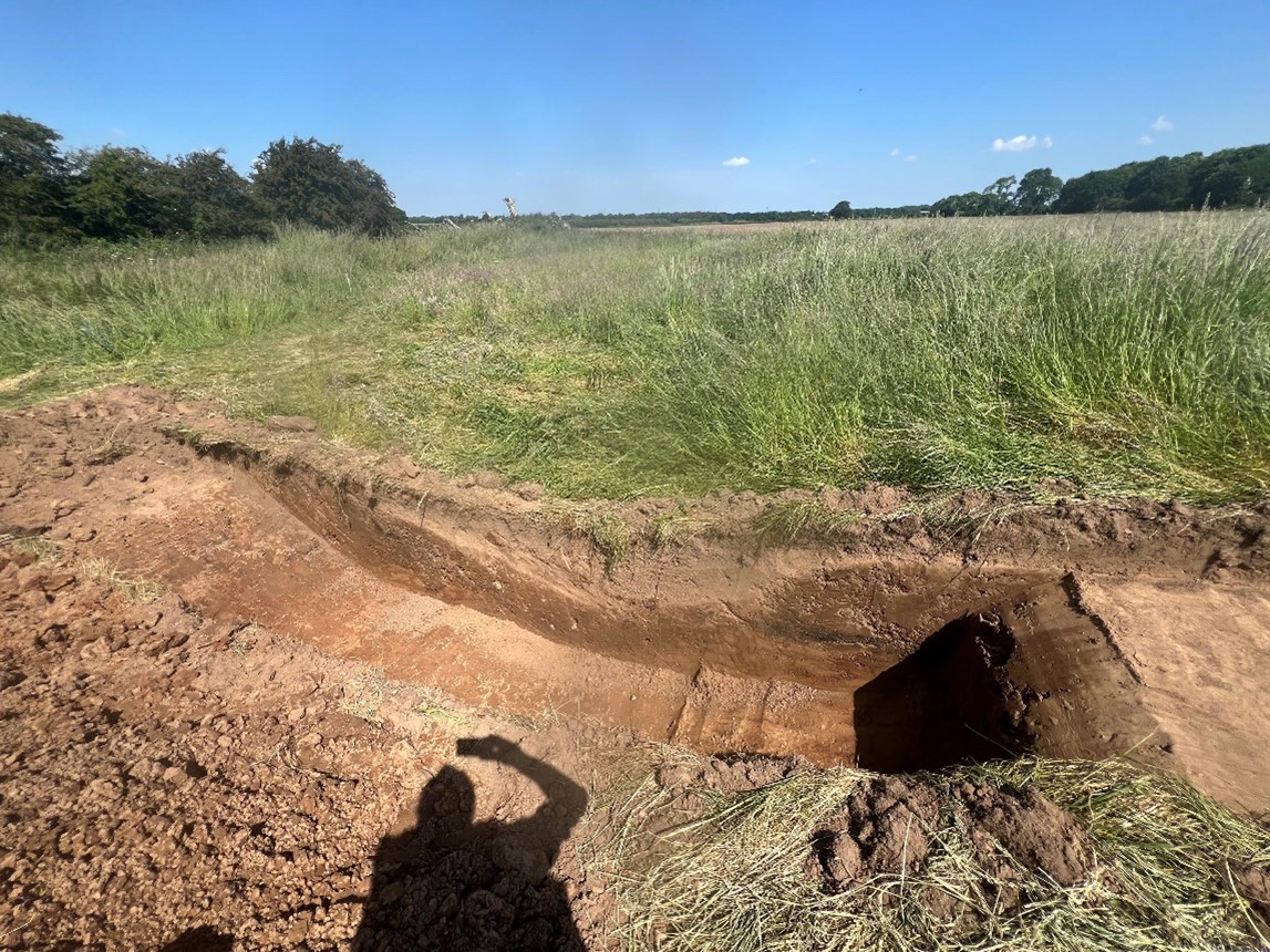
We had found it quite difficult since Monday to find the cut of the ditches from the natural, despite the clarity of their profile from outside of the trenches. While we had the JCB back on site, we thought it would be worthwhile to cut a little deeper into the ditch cuts on both Trench 1 and Trench 2 to determine more about them and their relationship to each other. Certainly, in Trench 1, we seem to have been able to find the extent of the cut and were able to record its measurements and draw sketches which will help us better interpret the nature of the earthworks as a whole. From this, it would appear that the mound was predominantly natural but had been reworked with an accompanying ditch cut around its perimeter.
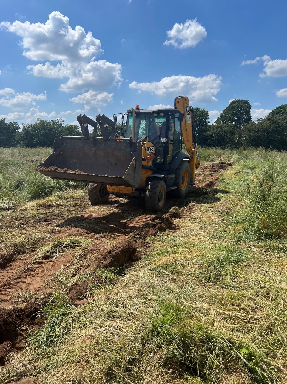
Again, with the aid of our JCB, we set to work backfilling the two trenches and making sure that the site was returned as much to the state it had been in prior to our arrival. After the welfare unit had been collected, we packed up the car with our equipment, and ensured that the finds would be safely transported back to the office ready for the next phase of our project. We also had a visit from the farmer who was able to point out some other features on the broader site that he had been aware, including a much smaller mound to the north in the adjacent field which had existed until it had been ploughed out some years before.
Now that the fieldwork has been completed, we hope to bring you more information in the coming weeks about what we have found. We are hoping that the picture will become clearer in the post-excavation phase, but Newhouse has undoubtedly proven to be a site even more intriguing than we had first thought it to have been.
Figure 1: Digging deeper into the ditch cut in Trench 1Figure 2: The ditch profile in Trench 1Figure 3: Trench 1 and Trench 2 were both backfilled before the end of the day
Dr Ryan Prescott updates us on what happened on day four of their dig
Today we have resumed our efforts in Trench 1.
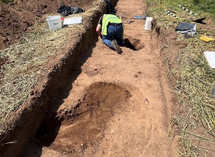
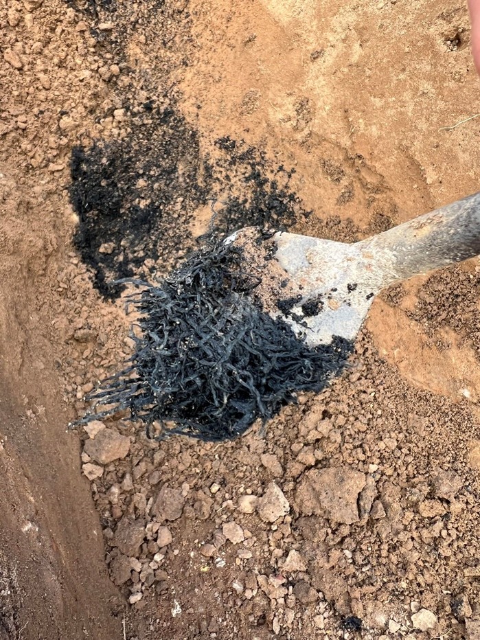
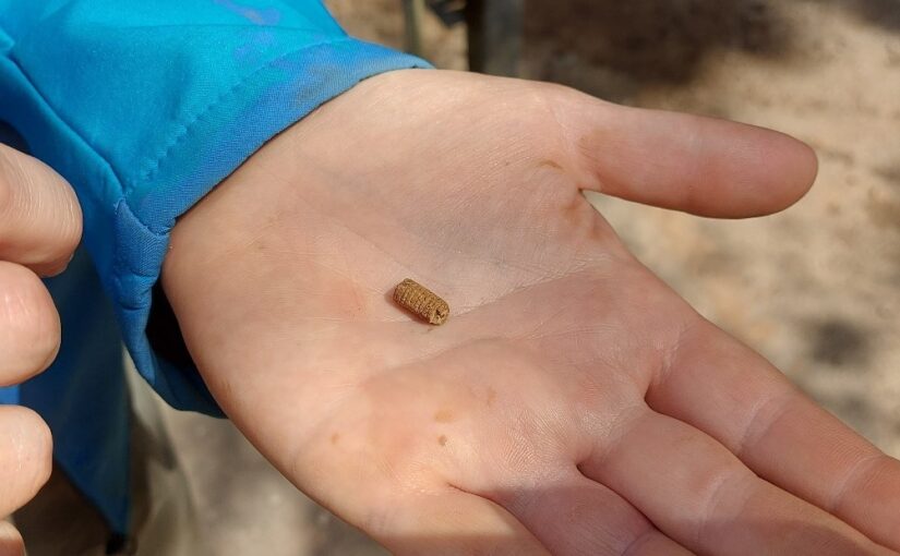
The two features that garnered our attention in day three required more investigation, so we set to work to try and find the underlying cause of what was going on. We had managed to recover the pot from Trench 1 yesterday, and it remains safely packed for analysis but today we focused on the feature in the centre of the trench where the piece of leather had been found. At first, it seemed that the find had been sitting on a bed of charcoal. However, upon closer inspection (and much more digging!) it revealed to be a deposit of textile material which has remarkably survived and will provide a fantastic source of dating evidence, together with the pot. Small fragments of medieval pottery were also identified in both Trench 1 and Trench 2, as well as further pieces of flint and small animal bone.
Before the end of the day, we also had a visit from the Lincolnshire Historic Environment Record, as well as Peter Connelly from Humber Field Archaeology and showed our visitors what we had found so far. We have all been sharing our interpretations on what we believe may have happened at Newhouse and we have all agreed that the site is far more complex than anticipated. Previous research on the site had only acknowledged its medieval history, chiefly the construction of the abbey on the site of an ‘Anarchy’ period castle. However, it does seem that the mound may have had a much longer pedigree of human occupation which would have been an attractive prospect for Peter of Goxhill who was only too aware of the castles and monasteries which were being founded by nearby lords at Barrow and Barton upon Humber, and was keen to emulate their efforts. We are hoping that the picture will become clearer in the post-excavation phase, but Newhouse certainly has an important story to tell.
We have one more day to wrap up our work at Newhouse for this year, but we have much more work to do before we leave site, so it is shaping up to be a busy day.
Ryan Prescott gives an update on what happened on the first day of digging at Newhouse
The first day of our excavations at Newhouse has provided some promising results already. This week we are excavating two trenches across the earthwork identified last year from geophysical survey (please look at our aims for this year on the CST Blog).
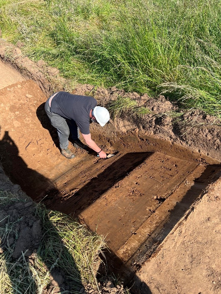
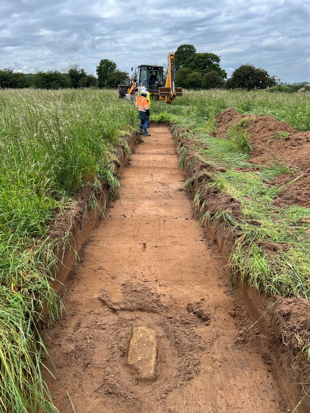
Trench 1 was swiftly opened with the aid of our JCB. It was hoped that this trench would help corroborate twelfth-century sources that a castle had existed prior to Newsham Abbey, founded here during ‘the Anarchy’. This trench was excavated diagonally from the west to the south-east of the earthwork in order to cut across two of its sides. However, we decided to extend our work in this trench with a perpendicular channel to the southern boundary. At a length of over 40m and 2m wide, the trench has yielded large quantities of flint, some of which appears to have been worked. We have also recovered evidence of burning and pottery finds which we will investigate further as the week progresses.
Figure 1: Trench 1 looking south.
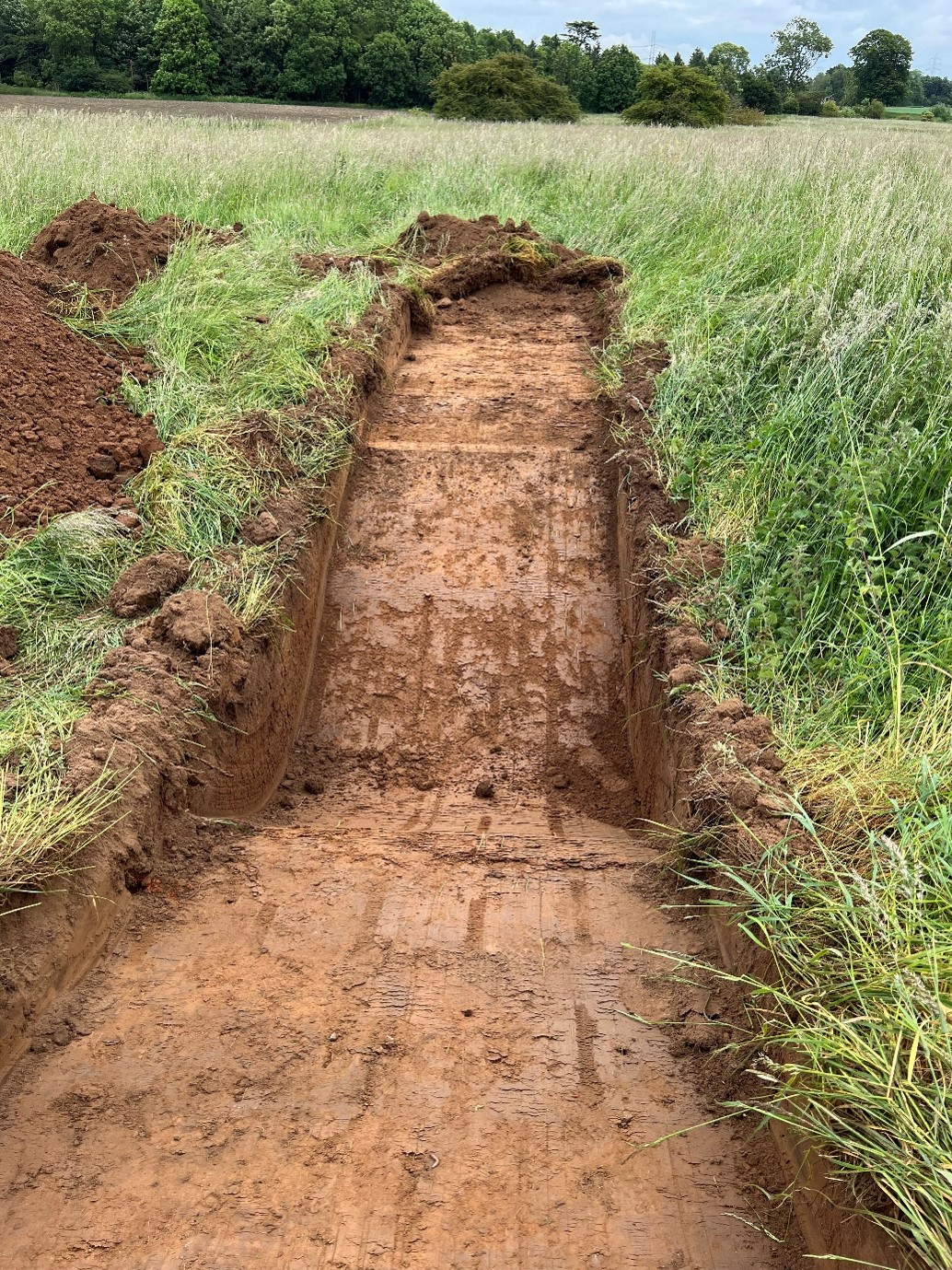
To provide more comprehensive insight into the nature of this three-sided earthwork, Trench 2 was dug across the eastern side of the raised platform and extends from its middle into the ditch on this side at a length of around 25m, slightly longer than initially planned. At first, this trench appeared to show little of interest. Undeterred, we decided to dig deeper into the ditch, and much like in Trench 1, it is clear from this that the earthwork would have been higher than the remains which are left behind. We plan to dig deeper into this later in the week. We cleaned the rest of this trench and discovered a masonry slab, hoping to have a better view of any potential finds and features on our second day when we return to focus on this trench.
Figure 2: Trench 2 looking west with a view of the masonry slab found there.Figure 3: The ditch being opened up in Trench 2 looking east
We are excited to see what the second day of the excavations reveals and will be posting updates as soon as we can.
In Week Fourth and final week of the Lowther Medieval Castle and Village Project 2024, the team moved into the UCLan labs. This crucial phase allows us to draw together the evidence we’ve collected last year and this, from the recording of trenches to the analysis of soil samples.
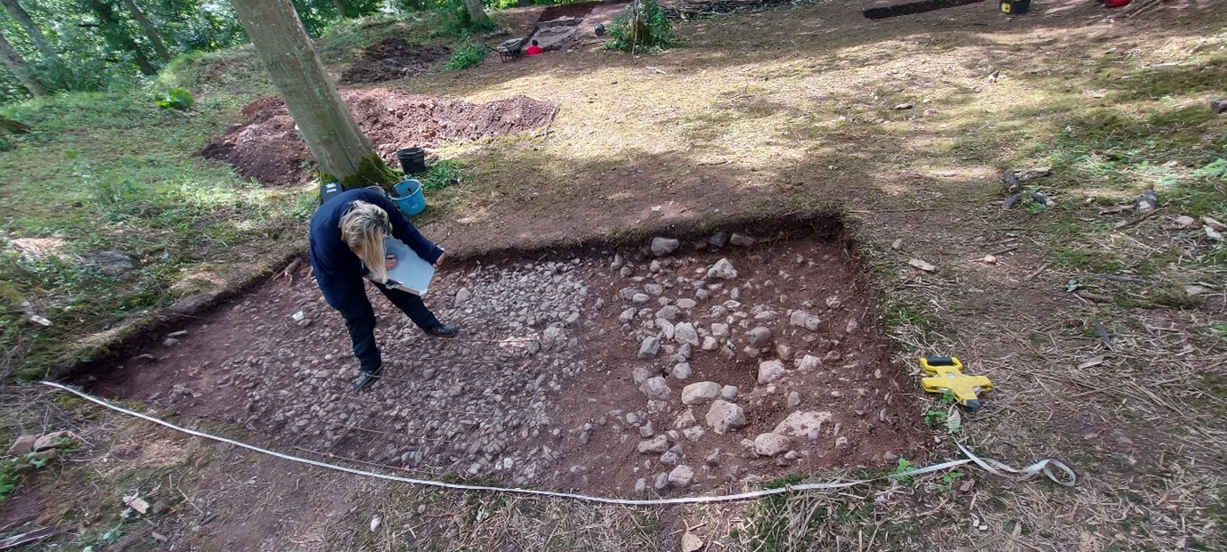
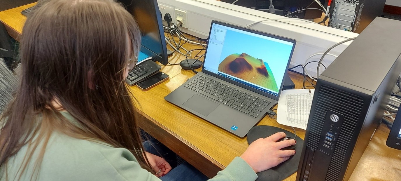
A major part of this process is the transfer of trench plans onto a Geographic Information System (GIS). During excavations, the dig team thoroughly recorded the contents of trenches in situ. This included the painstaking task of drawing the cobbled surfaces found inside the ringwork castle at 1:20 scale. Now, these hand drawings are transferred to the GIS and the outline of every cobblestone is traced digitally so that the archaeological contexts within the trenches be plotted with pinpoint accuracy.
Figure 1 Both last year and this, student archaeologists painstakingly recorded by hand the contents of all trenchesFigure 2 With hand drawings of trenches transferred to the project GIS, each component of the drawing needs to be traced digitally
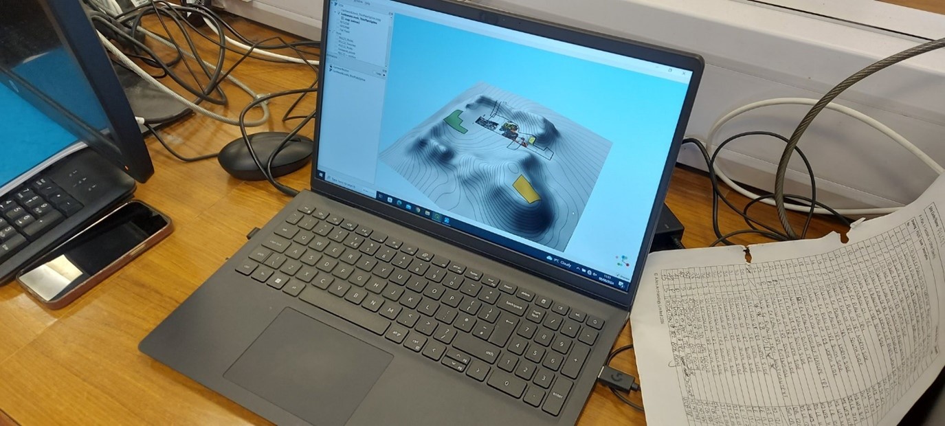
Meanwhile, the team is also plotting onto the GIS hundreds of data points from around the ringwork castle taken using a Global Positioning System (GPS). This allows us to create a three-dimensional digital model of the ringwork castle, in order to investigate its form and plot the positioning and contents of trenches from this year and last, building up our picture of the castle, its features and finds.
Figure 3 Taking hundreds of data points via the GPS enables the team to construct a 3D digital model of the ringwork castleFigure 4 Trenches from both phases of excavation can be plotted onto the 3D model of the ringwork castle using the GIS
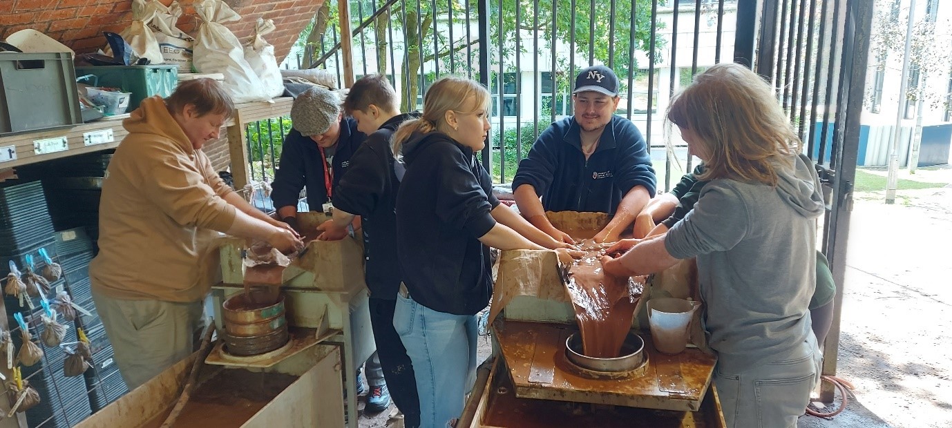
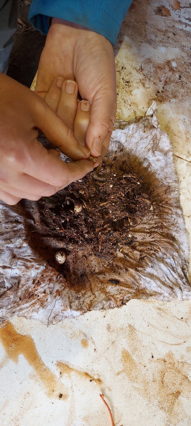
While one cohort of student archaeologists has been busy in the computer labs, another has been hard at work processing soil samples. Throughout the excavation, the team has been collecting bulk soil samples of 40 litres from all trenches. These samples have now been processed using water flotation, in order to recover charred plant remains, as well as small bones and artefacts. This has so far yielded environmental evidence such as tiny snail shells, which can be analysed to reconstruct the surrounding environment at the time the ringwork castle was built.
Figure 5 Dozens of soil samples have been processed using water flotationFigure 6 Soil sample processing yields environmental evidence, such as tiny snail shells
Now that Phase Two investigations are drawing to a close, the team has also been able to take stock of the small finds garnered this year. As discussed in our last Dig Diary, this year’s finds have included cockle shells and gritty ware pottery, both of which will help us to date the castle and trace activity at Lowther in the Middle Ages. This builds on intriguing earlier finds this year of animal bones, including an articulated fetlock (discussed in our first Dig Diary this year). We can now add to this a bone bead, small but delicately carved, which looks to be dateable to the Middle Ages.
Figure 7 A small carved bone bead found during this year’s excavation
Work on analysing these finds – and the broader phase of analysis – is ongoing, and will be compiled into the project’s second interim report in due course.
Jo Kirton and Graeme Young, co-director of the Bamburgh Research Project (BRP) outlines what happened during their 2023 season and what the CST funded part of the research at this iconic castle revealed.
Throughout July 2023 BRP staff ran our annual field school at Bamburgh Castle, which is currently exploring the medieval outworks at the northern tip of the castle. We also welcomed several experts to site, funded by our CST grant, to undertake complementary survey alongside our excavation.
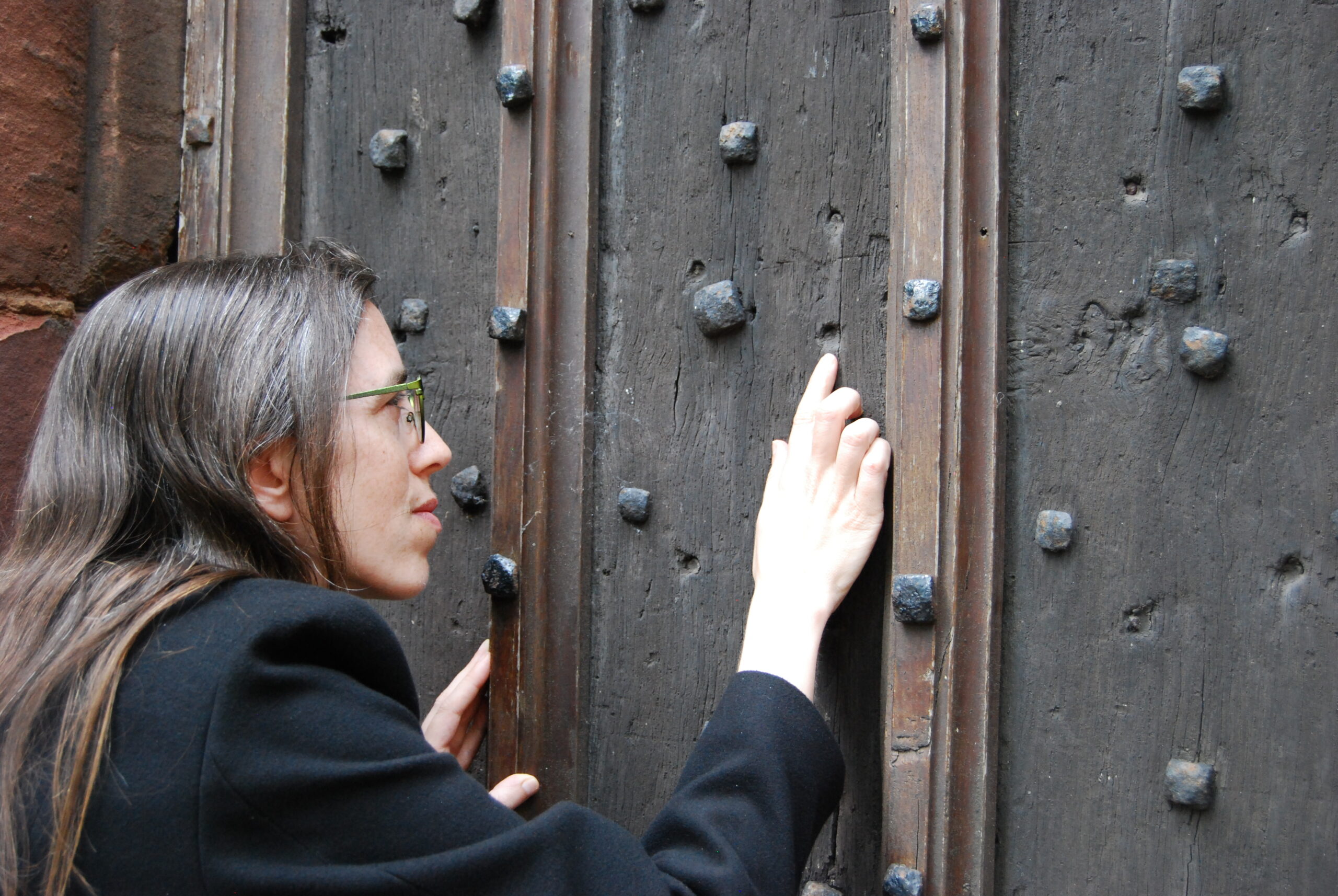
Historic Building Consultant Peter Ryder joined us to undertake a preliminary masonry survey of the extant outworks while Tony Liddel from Vindomora Solutions created several 3D models of the standing outworks and internal structures of Elmund’s Tower and our associated trenches. Dr Kristian Strutt and his team from the University of Southampton undertook a geophysical survey of the castle ditch and explored how this interacts with the outworks, as well as identifying related features and access ways to St Oswald’s Gate. BRP staff and students worked with the team, trying their hand at GPR, resistivity and magnetometry.
The reports from the masonry and geophysical survey, plus the associated3D models have now been completed and incorporated into the BRP’s Interim Report on Work on the Outworks Beyond St Oswald’s Gate. This is a summary.
Background
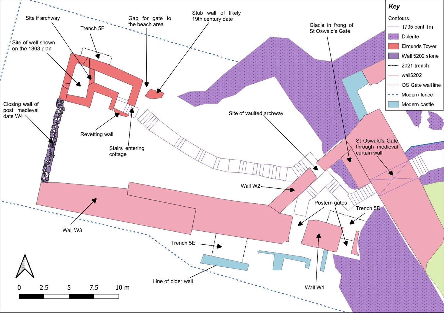
The Bamburgh Research Project (BRP) was set up in 1996-97 to undertake archaeological investigation of Bamburgh Castle and its environs. The area immediately within St Oswald’s Gate was investigated in an effort to identify early elements of the fortification and structures associated with the entrance; documentary evidence indicates that this gate was the principal, and perhaps only, entrance to the fortress in the 8th century AD and likely remained such until the main gate was relocated to its present position in the 12th century.
The rock outcrop on which Bamburgh Castle stands is comprised of volcanic dolerite that rises some 30m above the external ground surface. The surface of the plateau is c.3 hectares in area. It undulates in height, sloping downwards from the Inner Ward area at the south-east, which reaches 45m OD, to the north-west end of the West Ward where St Oswald’s Gate lies. Here a natural cleft in the bedrock on the landward side leads out and down the slope of the plateau. This has formed a natural route up to the summit from earliest times bridging, if awkwardly, the height difference between the West Ward at some 22m above sea level and the surrounding ground surface that lay at 13m OD. St Oswald’s Gate is written about as the entrance to the fortress of Bamburgh in the 8th century AD (Symeon HK, III. pg 37) and was very likely the earliest route up onto the rock plateau.
The present phase of work began in the summer of 2021. We are investigating the entrance, the access routes up to the entrance and the structures and outworks built to control this route over many generations. One area of focus was the recovery of the site of the Tower of Elmund’s Well, named in records from the 13th century (Colvin, H. M. 1973, 556) and onto which a cottage was constructed in the late 18th century.
The plan outline of the cottage/tower structure was quickly revealed during the first phase of investigation by the removal of foliage and a modest volume of aeolian sand. One of the first exciting discoveries during the 2022 excavation was the presence of two splayed lights (open window-like features) in two of the walls.
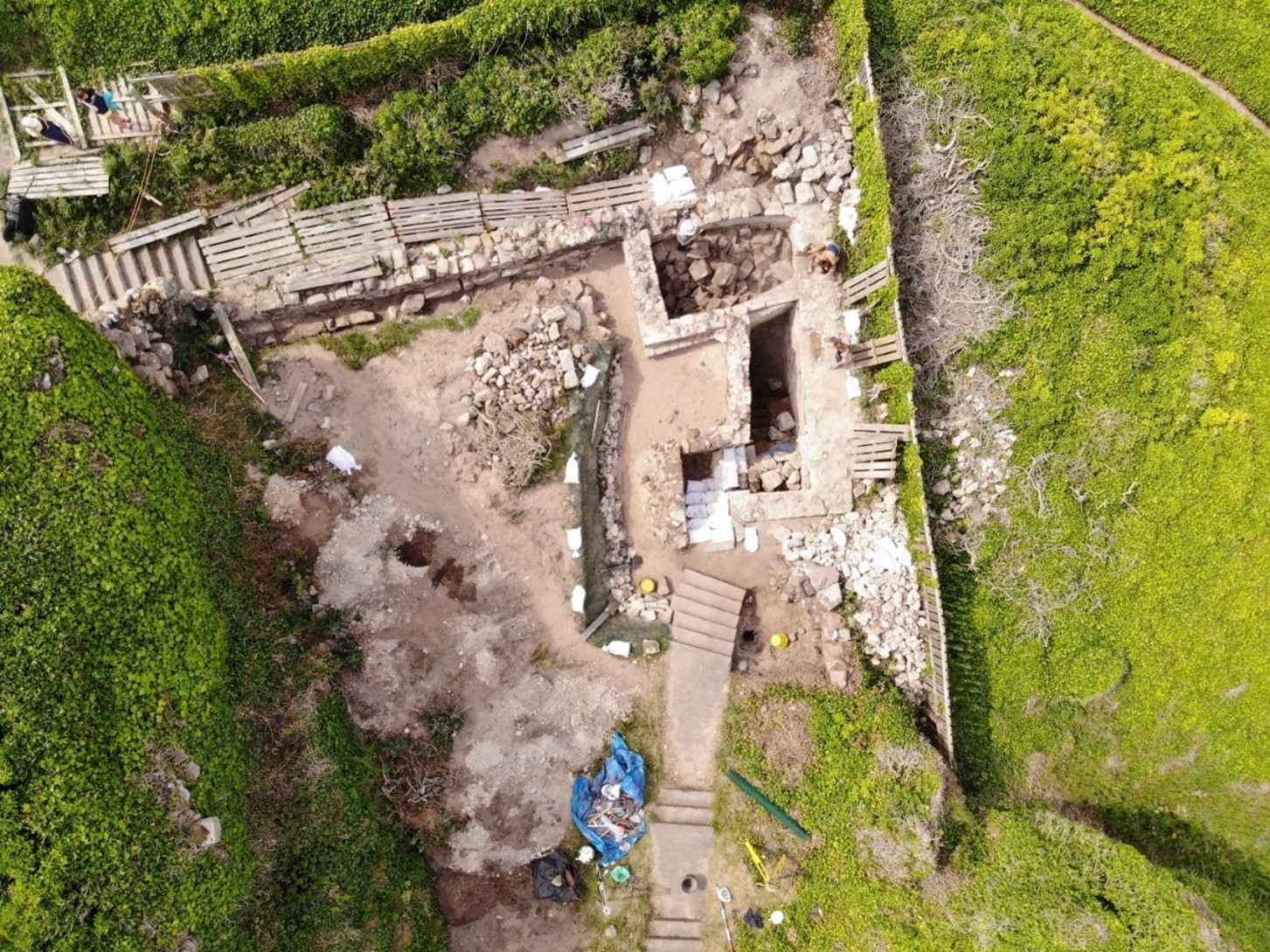
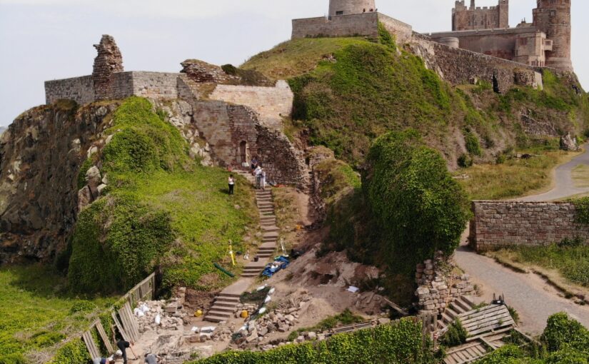
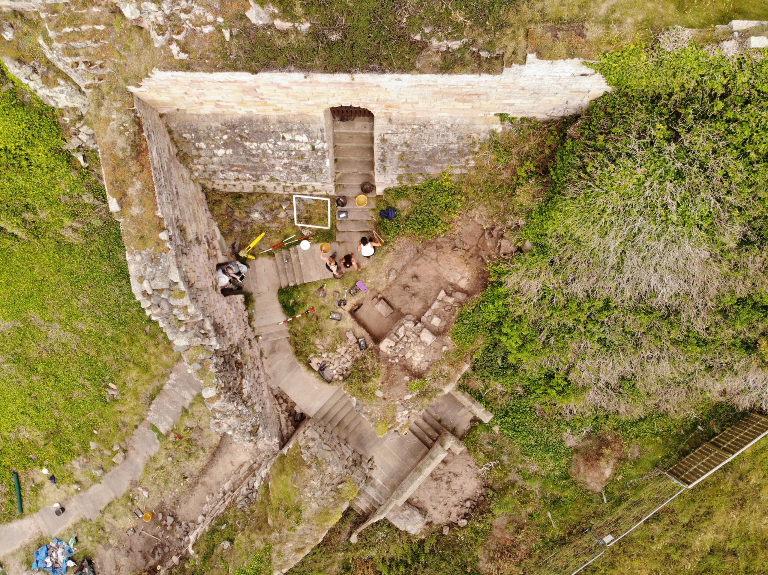
Figure 1: Aerial photo of the outworks with the cottage/tower seen in the top right corner. The steps that lead back to St Oswald’s Gate, through the Wing Wall, at the bottom of the photo. Facing west. Copyright Bamburgh Research Project
The elements of the cottage are now exposed fully in plan and when interpreted alongside the available cartographic evidence would suggest that the entrance was re-aligned due to the build-up of sand deposits in the area that have been slowly burying the standing structures during the post-medieval period. Two short flights of more recent stairs, each turning through a right angle, lead to a long straight set of stairs of older character and showing substantial wear, that extended down through the arch to the basement of the tower where we know from cartographic evidence the well was once present, in what is now a basement room. Here excavation must be getting close to the floor level and some four phases of build are seen in the exposed walls that now reach almost two storeys. The lower two of these phases are likely to be elements of the medieval tower and the upper, by default, phases of the cottage that was built on and into the tower from the 18th century.
There was further work on the postern gate that lies beyond St Oswald’s Gate that leads out to the village which had been subject to limited survey and excavation in previous seasons. Continued excavation immediately behind the wall that leads back to the castle rock has uncovered more of the structure. We intended to uncover more of the wall, recover some datable finds and identify the level from which it was constructed. The structure as uncovered is a single well-constructed feature of coursed squared masonry that ended abruptly and deliberately short of the rock. A further constructed face abutted the bedrock and the gap between the two faces is a little more than 1m wide, forming what must have been a second gate. The eastern of the two is likely the earlier of them and must have led to a timber stair as it is well above ground level. The western, that is currently still in use, may have replaced it as more practical as it is closer to ground level, though still reached by stairs, the current version of which appear to be late post-medieval. This wall extends well to the west where a form of it turns to the north towards the tower/cottage. All the elements that are currently exposed appear to be late in date and the medieval wall must lie beneath the current ground level.
In 2023 we opened Trench 5E, sited outside of the wall with the postern gate and the outworks. It was placed next to a short length of wall that we investigated last season to see if it had once extended further. It has revealed a stone alignment that extends parallel to the two standing walls. Those of the outworks and the short wall length. So far only the upper level has been uncovered, so it is possible that it could be either a wall top or a foundation or the surface of a narrow path.
Work supported by funding from the CST
CST funded BRP to undertake additional non-invasive survey work to offer additional context to the excavation outlined above. Initially, and to better frame the results of the geophysics and limited excavation a walk over study was undertaken by BRP and Peter Ryder. This aimed to provide a description of the standing structures in their historical context, as they are currently understood and was supported by selected areas of photogrammetry survey.
St Oswald’s Gate itself extends out through the curtain wall to the landward side at the northern end of the castle. It passes through a vaulted tunnel to the gate and appears to represent two phases of medieval build with a third – post-medieval – phase represented by internal and external refacing, likely of the late 18th century.
One of the most enigmatic features is the Wing Wall (W2 (see Figure 2) that forms a partial barrier to the route down from the gate. It appears to be one of the older elements of the defences with at least four phases of masonry (see Figure 3) and is relatively narrow compared to the later medieval defensive walls, such as the South Wall (W2) that cuts and post-dates it. It also contains an unusual arched doorway of early form that may be reused from elsewhere.
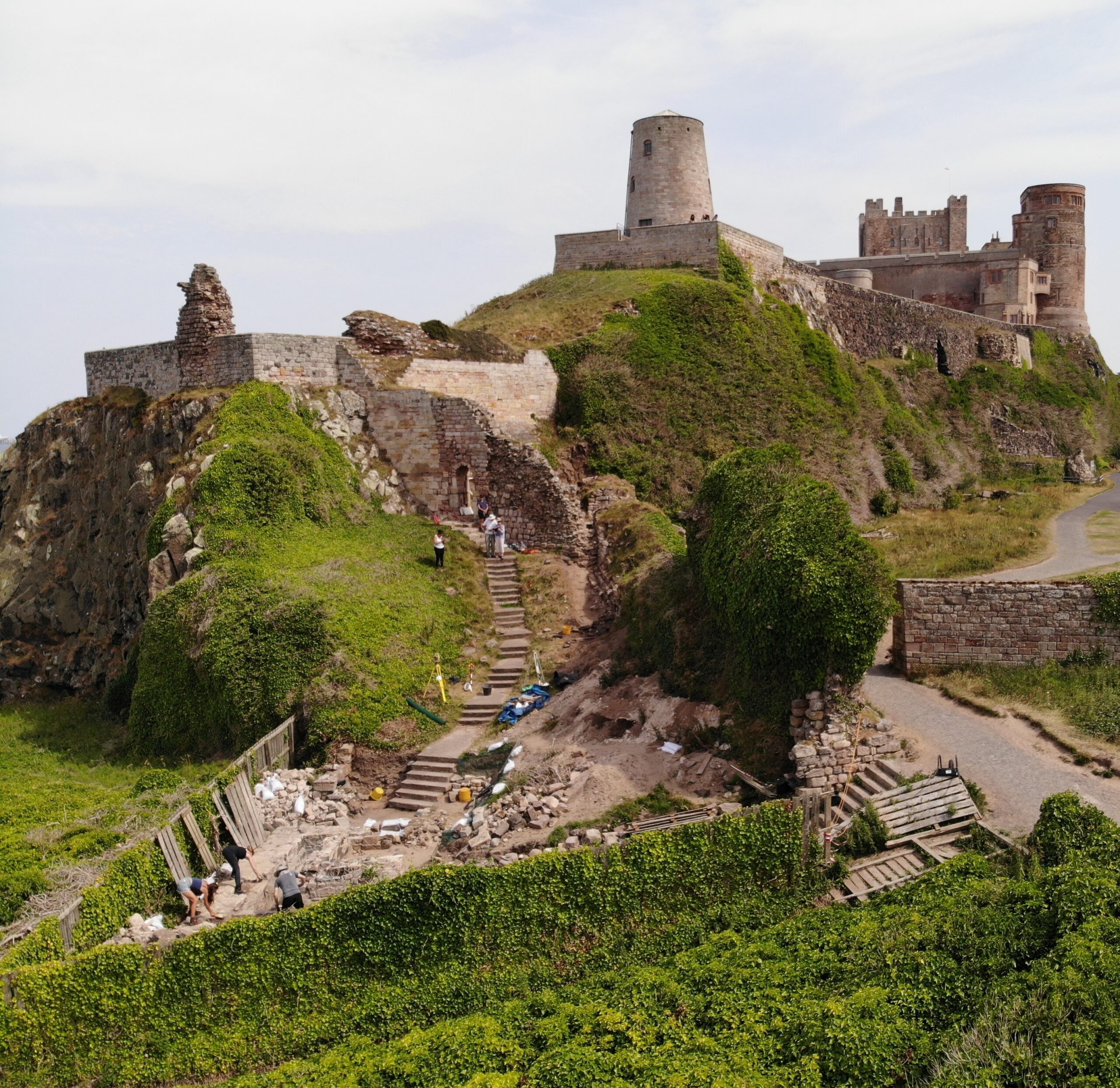
Figure 2: The northern extent of Bamburgh Castle showing the site of the outworks and the silted tidal port. Copyright Bamburgh Research ProjectFigure 3: The narrow ‘Wing Wall’ showing the narrow archway and multiple phases of construction, facing north-west Copyright Bamburgh Research Project
The south Wall (W1 and W3) comprised at least two build elements that joined with an overlapping joint. The wall as we now know through excavation had two postern gates that would have led to the village.
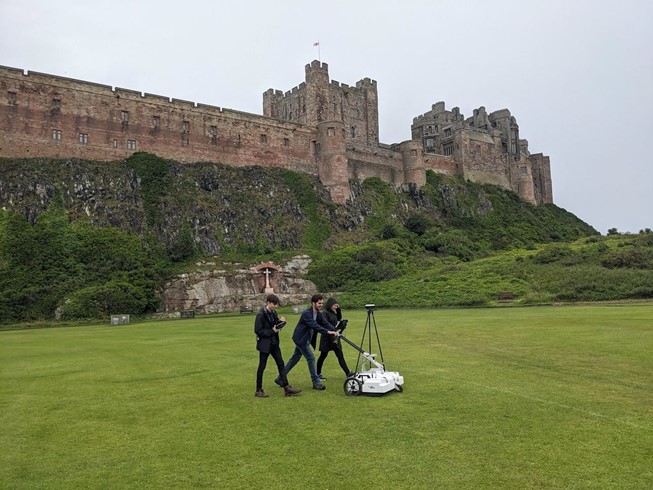
In addition to the masonry and photogrammetry survey, Dr Kristian Strutt undertook magnetometry, resistivity and Ground Penetrating Radar (GPR) survey of areas of the Cricket Ground to the west of Bamburgh Castle. The results indicate the possible presence of a large ditch, some 45m across, immediately to the west of the outcrop, in addition to trackways, walls and other features.
Figure 4: GPR survey under way across the Cricket Ground using an Impulse Raptor 8-channel system and GPS (photo: K. Strutt)
One of the principal questions we were hoping to address with the geophysics was if the castle ditch extended across the sports field at the base of the castle rock. A ditch cut through sandstone can been traced in the area of the modern entrance that is at the site of the 12th century gate. This feature extends across the front of the castle as far as the sandstone ridge. The results of the GPR seem to strongly indicate a large feature in the area where we would anticipate the castle ditch to be and the magnetometry and resistance surveys seem to support this. It is intended to conduct further fieldwork, starting with coring, to confirm this.
In addition, several features seen on the 1865 1st Edition Ordnance Survey (Accessed via National Library of Scotland online 23/04/2024) appear to be picked up on the surveys. Two trackways are evident, that lead to St Oswald’s Gate and to a cleft in the castle rock called the ‘Miller’s Nick’, which allowed people to scramble up to the West Ward in the 19th century. The second is an S-shaped path that meandered towards the area of St Oswald’s Gate, perhaps originally skirting around the edge of the ditch feature. One further route-way or path extends across the field parallel to the road in the village to the south, called the Wynding, that appears from records to have had a medieval origin. This path runs alongside a linear plot boundary and field boundaries and it will be interesting to see if more can be made from a number of anomalies within the enclosure areas to the south and west of the plot.
The resistivity and ground penetrating radar surveys so far cover a more limited area, due to time constraints and public access. There is an area of low resistance that lies just where the ditch would lie and matches up to the path towards the Miller’s Nick. The enclosure areas picked up in the magnetometry to the south-west also seems to be present on the resistivity. Notably, there is a high resistance feature that the S-shaped pathway may curve deliberately to avoid at the south part of the plot. A further T-shaped high resistance feature is present in the north-east extending from the area of the modern pavilion that will bear further study. The GPR further reinforces the presence of some of these features and indicates some depth to the anomaly that is interpreted as the ditch, though the signal attenuates before it could indicate a true depth.
Together, the on-going excavation and non-invasive survey work undertaken in 2023 are providing us with the opportunity to better understand the castle outworks, north of the castle, and the wider environs in which they were situated. That this area of the castle was its original entrance, and for a time gave access to a modest port, ensures that there is much yet to be discovered and understood.
Interim Report
If you would like to read more about the excavation, masonry survey & 3D models and/or the results of the geophysical survey with accompanying discussion, please take a look at
Ryder, P. 2024. Preliminary Assessment of the Standing Masonry Elements: St Oswald’s Gate, the Western Outwork and St Elmund’s Well Tower, Bamburgh Castle, Unpublished Report
Strutt, K and Barker, D. 2024. Report on the Geophysical Survey at Bamburgh, Northumberland, July 2023Department of Archaeology, University of Southampton: Unpublished Report
Symeon, H. K. Historia regum Anglorum et Dacorum (trans. J. Stevenson), 1858, Church Historians of England
Berkeley Castle Project Excavation Director Dr Stuart Prior takes a look at one of the many interesting discoveries made during the dig which is part of a new book looking at 15 years of excavation.
Between 2005 and 2019 the Berkeley Castle Project (BCP), conducted by University of Bristol, carried out excavations and survey work at Berkeley Castle, which have led to the publication of a new book. Excavations in 2015, of Trench 19, were able to gain insight into the early origins of the castle and the donjon that was constructed when the castle was built in stone by Robert FitzHarding in 1153–1154.
It was originally believed that the first stone castle erected at Berkeley comprised a circular shell keep, but the BCP was able to shed new light on this aspect of the site’s past and its architectural evolution. In a Castle Studies Group Bulletin (CSG Bulletin 18, 2014), Neil Guy suggested that the castle may have had a square or rectangular donjon or keep that may have been modified as the basis for the Thorpe Tower by Thomas [III] Berkeley (1292–1361). Trench 19 was designed to look for evidence of the north-west corner and west wall of this postulated donjon. The argument here was that Thorpe Tower was not wholly created ‘as new’ in the 14th century but was instead a part-relic structure arising from a 1340s re-modelling of the 12th century castle. Namely, two corners and one side of a square donjon which abutted the north side of the ‘motte’, and for which the shell-keep encasing the motte was an inner (and elevated or upper) bailey.
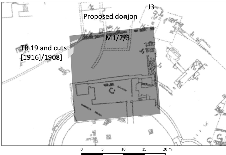
Figure 1: Plan view of Trench 19 showing heavily robbed-out building foundations copyright Berkeley Castle Project
The archaeological remains observed in Trench 19 (Fig. 1) appear to demonstrate the presence of a heavily robbed-out building with structures of two later phases overlying it (Fig. 2). The orientation of the first structural phase (contexts 1912 and 1916) and the robber trench (context 1908) associated with it is in alignment with the south-facing elevation of Thorpe Tower. This orientation suggests that this first phase was associated with, and presumably connected to, Thorpe Tower. It is probable, therefore, that context 1912 represents a heavily robbed wall which is comparable, and most likely contemporary with, wall J3, identified by the 8th Earl, who was an amateur archaeologist, which extended from the northern elevation of Thorpe Tower (TBGAS, 1927, vol.49, 183-93 & 1938, vol.60, 308-39).
Figure 2 – Location of proposed donjon overlying plan of 8th Earl’s excavations. Copyright Berkeley Castle Project
It appears then that the shell-keep and Thorpe Tower are of a single phase, most likely dating to the mid-12th century. While there is no evidence currently that contexts 1912, 1916 and wall J3 are contemporary with this primary construction phase, it must be noted that the wall (1911) overlaid context 1912 and re-used some of its stone. Further to the evidence from Trench 19, the rear wall of this fortification can still be seen, incorporated into the castle’s later form (Figs. 3 & 4).
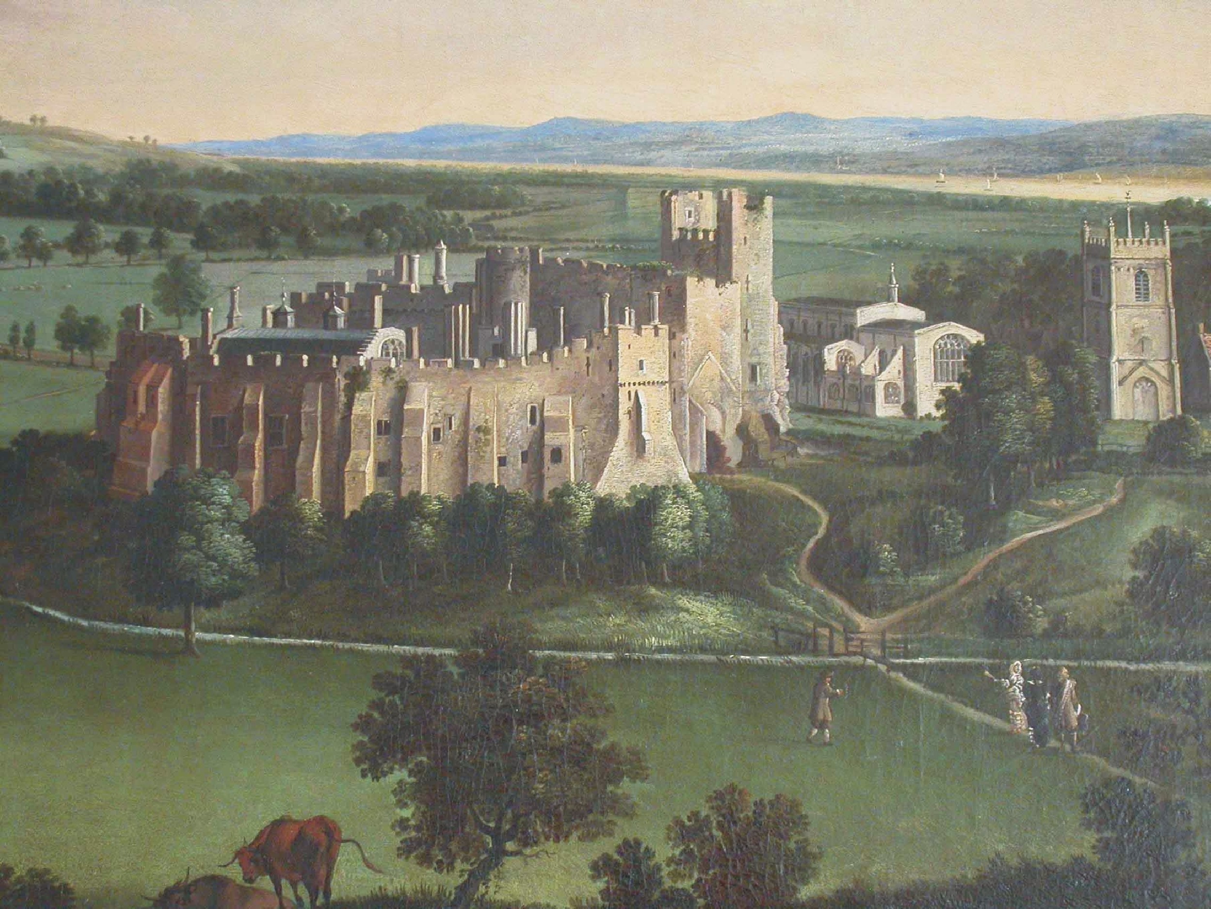
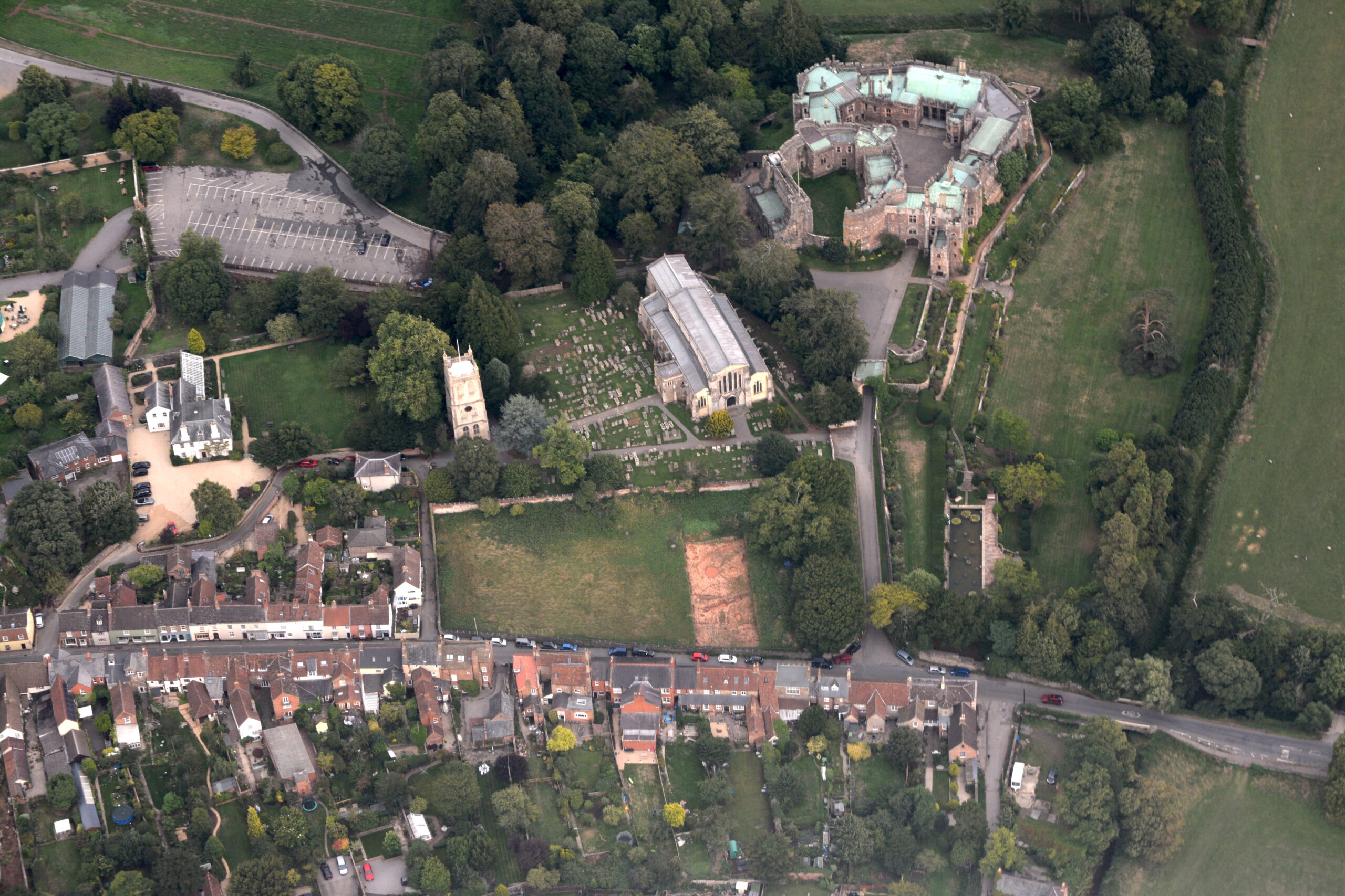
Figure 3 – 17th century painting by Dankerts showing original height of donjon along with remnant of projecting wall (heading north towards church).Figure 4 – Aerial view of Berkeley showing reduced height of donjon; and with addition of 18th century laundry attached to north. Copyright Berkeley Castle Project
Accompanying the donjon, there are several medieval documents that record the cutting of moats around Berkeley Castle. In The Cartulary of St Augustine’s Abbey, Bristol, an entry made between 1171 and 1190 records a grant made by Maurice de Berkeley [I] to St Augustine’s of a rent of 5s from his mill below the castle, some tithes of pannage, and common pasture for a plough team ‘pro emendatione culpe mee de fossato quod feci de cimiterio de Berchel circa castellum meum’ (charter no. 78; Walker, 1998, 46–7), which roughly translated means ‘in recompense for my offence committed upon the cemetery of Berkeley in cutting a ditch around my castle’. This suggests that Maurice cut a moat around his castle, which encroached upon part of the cemetery, and he was subsequently fined for his actions. The grant is again confirmed sometime between 1190 and 1220 by Maurice’s son, Robert [II] (charter no. 119; ibid., 69–70).
During this period then, the castle comprised an ovoid shell-keep with adjacent forebuilding, the curtain wall of the inner ward and the Norman Great Hall, all wrapped around the skeleton of the earlier motte and bailey. Excavations carried out by the 8th Earl between 1917 and 1937 (TBGAS 1938, 321) demonstrated that the shell-keep was already adequately defended by a moat that ran around its base on the southwest, north-west and north-east sides – which may have encircled the earlier motte and bailey – and records show that Maurice [I] dug a deep moat around the south-east side of the castle, presumably to complete the defensive circuit, and diverted the Newport brook and others towards the castle to fill it.
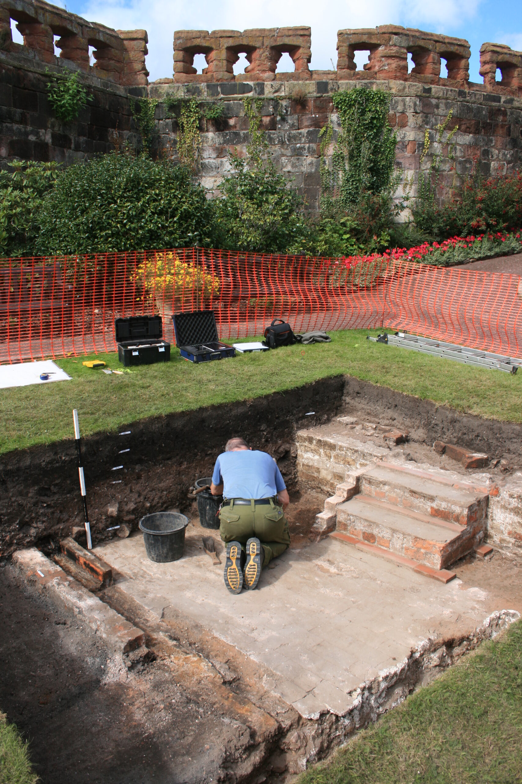
With the excavation report on the third and final season of excavation which the CST has funded now published on our website, project lead Dr Nigel Baker looks at what has been achieved since the first work in 2019 to now.
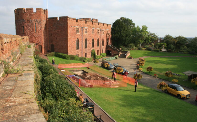
Just over a century ago Shrewsbury Castle began a new phase in its long life. In 1925 its principal surviving building, having been in use as a private dwelling since the castle was finally de-munitioned in 1686, became the meeting hall of Shrewsbury Borough Council, set in extensive landscaped gardens covering the remains of the motte and inner bailey, the outer bailey having (mostly) disappeared beneath the growing town by c.1300. Shrewsbury Castle remained more or less untouched by archaeology for the remainder of the 20th century. This changed in 2019 with the award by the Castle Studies Trust of a grant for a season of geophysical survey and excavation in the inner bailey. Following permission from Shropshire Council, the site owners, and Historic England, its legal guardians, the work took place in May and July 2019, the geophysics by contractors Tiger Geo and the excavation team made up of experienced local volunteers and staff and students of University Centre Shrewsbury. The results were unexpected.
Shrewsbury Castle Excavation 2019 showing the width of the ditch around the motte using deckchairs (copyright Dr Nigel Baker)Arrow heads found in Shrewsbury Castle Motte Ditch (copyright Dr Nigel Baker)
Immediately under the turf was natural glacial gravel: the top of the hill on which the castle had been built; the ground surface had been lowered sometime in the past, removing nearly all archaeological remains. This was almost certainly the work of the young Thomas Telford who, from 1786 to 1790, lived in and ‘restored’ the castle for its owner, Sir William Pulteney, M.P. for Shrewsbury. However, archaeological strata were found to have survived within cuts into the natural gravel, and two of these were of major significance. The first was the edge of a previously-unknown ditch around the base of the motte. Medieval cooking-pot sherds of late 11th-13th-century date were found in its lowest excavated layers, along with two armour-piercing crossbow quarrel heads. The second significant find was of a pit containing in its fill a piece of decorated bone and two types of pre-Conquest (Saxon) pottery: Stafford-type ware, distributed widely across the emerging towns of the region and already well represented in Shrewsbury; and a limestone-tempered fabric, TF41a, never before seen in Shrewsbury, which had been made in the Gloucester area and probably imported up the Severn. This confirms that there was pre-Conquest activity on the site of the castle, and, along with the Domesday evidence that there was a church of St Michael there by 1086, may point in the direction of a high-status pre-Norman presence on this tactically-significant site controlling access to the ancient borough.
Shrewsbury Castle Excavation 2020 (copyright Dr Nigel Baker)
Excavation resumed in the autumn of 2020 with a trench seeking a sample profile through the west rampart of the inner bailey. This turned out not to be medieval in date. Both the west and the north rampart were probably created as part of Thomas Telford’s landscaping work in 1786-90. But, intriguingly, below the west rampart there was no sign within the trench of the natural hilltop gravel found close by in 2019 at a depth of just a few centimetres. The explanation may be that the bailey was enlarged westwards between the Norman period and the later medieval period, by dumping soil and levelling-up behind a new curtain wall.
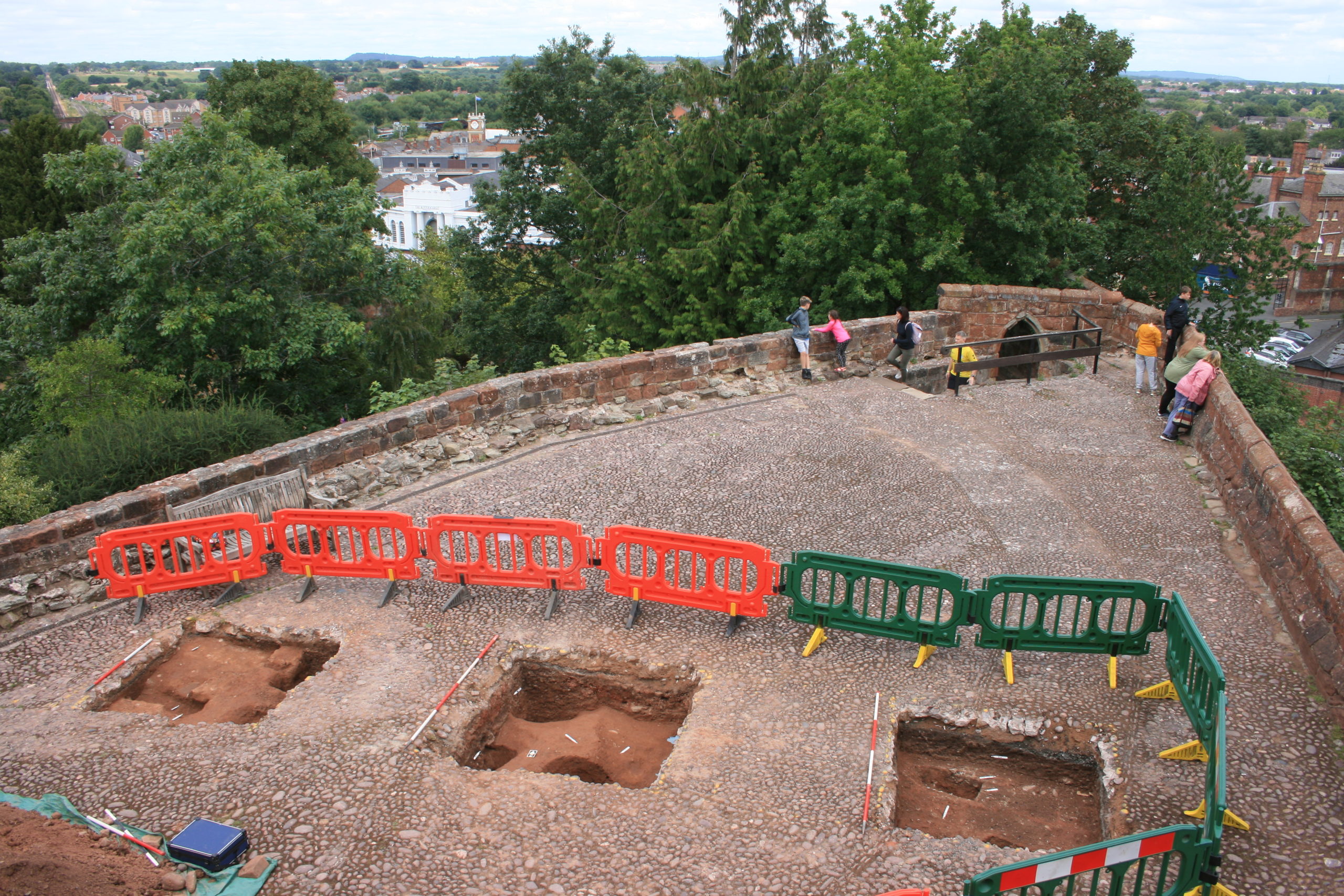
Shrewsbury Castle Excavation 2022 on the motte top (copyright Dr Nigel Baker
The final season of excavations took place in 2022 on the top of the motte, and outside the north curtain wall. Telford is known to have demolished ruined medieval buildings on the top of the motte and replaced them with the surviving two-storey Gothic summerhouse there. Excavation showed that Telford’s activities had, again, removed most of the archaeology but that the foundations of early medieval timber buildings (beam slots, a post pad, post holes) survived where they had been cut into the motte material. No definite trace was seen of the ‘great wooden tower’ which is documented on the motte top until its collapse in 1269-71.
New light was also shed on the motte by vegetation clearance on its south side, revealing for the first time remains of buildings incorporated in the masonry of the retaining walls. This work was undertaken on behalf of Shropshire Council for a new conservation-management plan, currently at consultation stage, which includes photogrammetric surveying of all the castle structures. This permanent stone-by-stone record not only forms the basis for the next vital stage of work – identifying and specifying long-needed repairs – it also offers new archaeological insights, including the identification of the probable primary sandstone rubble fabric of the curtain walls. This was in turn followed by some research carried out by Jason Hurst on Civil War musketry damage in 2023 (Potential shot damage at Shrewsbury Castle – Castle Studies Trust Blog) . And now, the process of publishing this body of new archaeological, architectural and historical information is just beginning…
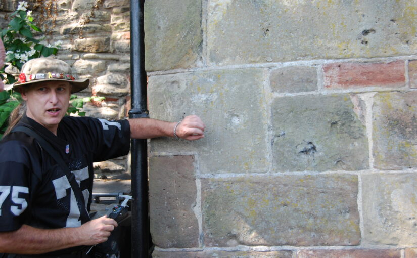
Jason Hurst from the University of Leicester’s School of Ancient History and Archaeology and expert on civil war damage to castles looks at the damage at Shrewsbury Castle.
In June this year I went with Dr Nigel Baker, and Dr Morn Capper of University Centre Shrewsbury, to examine suspected musket/weapon projectile damage inflicted on the Castle, possibly during the Parliamentarian assault of February 1645.
Dr Morn Capper showing the damage to Shrewsbury Castle’s main gate
When inspecting the marks on the main castle gate I concluded that these were from musket/pistol ball strikes with some indication of possible fragments of these projectiles still embedded in the woodwork, along with possible residues.
Shrewsbury Castle Postern Gate Gun Shot Damage
On the outside of the Postern Gate the identification of some of the marks could not be positively made because of weathering, but intriguing larger impact marks seem to be from a small calibre artillery piece, possible a Robinet or similar sized calibre gun.
At the north end of the hall, facing the railway station, are marks that look like weapon projectile strikes but their trajectory is problematic. Some appear to have come in at a level trajectory towards the wall and some from a downward trajectory, so these need to be looked at in more detail to determine what has caused them.
Dr Jo Kirton co-director of the Bamburgh Research Project takes a look at the work they are doing at Bamburgh Castle, funded by the Trust.
Throughout 2023 and early 2024 the Bamburgh Research Project will be utilising funding from the Castle Studies Trust to further explore Bamburgh Castle’s medieval outworks, particularly the area outside St Oswald’s Gate where our current excavation is underway as part of our annual field school. Our project is titled ‘Contextualising Bamburgh Castle: wells, towers, mounds and more!’
crForeground shows the area currently under excavation by the BRP with St Oswald’s Gate visible at the top of the steps and West Ward of Bamburgh Castle present in the background.eated by dji camera
Bamburgh Castle
Bamburgh Castle rises from the North Sea coast of north Northumberland. It lies on an undulating, 3.2-hectare, outcrop of dolerite bedrock that stands up to 30m above the surrounding countryside. Bede describes it as a palace site of the Anglo-Saxon kings of Northumbria from the later 6th century and it remained a royal castle until its semi-abandonment after a great siege in 1464. Rebuilt by the Lord Crewe Trust in the 18th century and again by the 1st Lord Armstrong at the end of the 19th, the fortress has long held a special place in the history and culture of the region.
The majority of the archaeological work at Bamburgh has concentrated in the low-lying West Ward at the north of the castle. A complex deeply stratified, finds-rich, site has been revealed archaeologically. By contrast, the Inner Ward of the castle, at the very top of the hill, remains a built-up area. Modest scale excavation of the accessible areas has provided an important balance, giving insight into the heart of the citadel to contrast with the occupation and industrial activities we see in the West Ward.
Aerial shot of St Oswald’s Gate with steps leading down to current excavation area.
St Oswald’s Gate
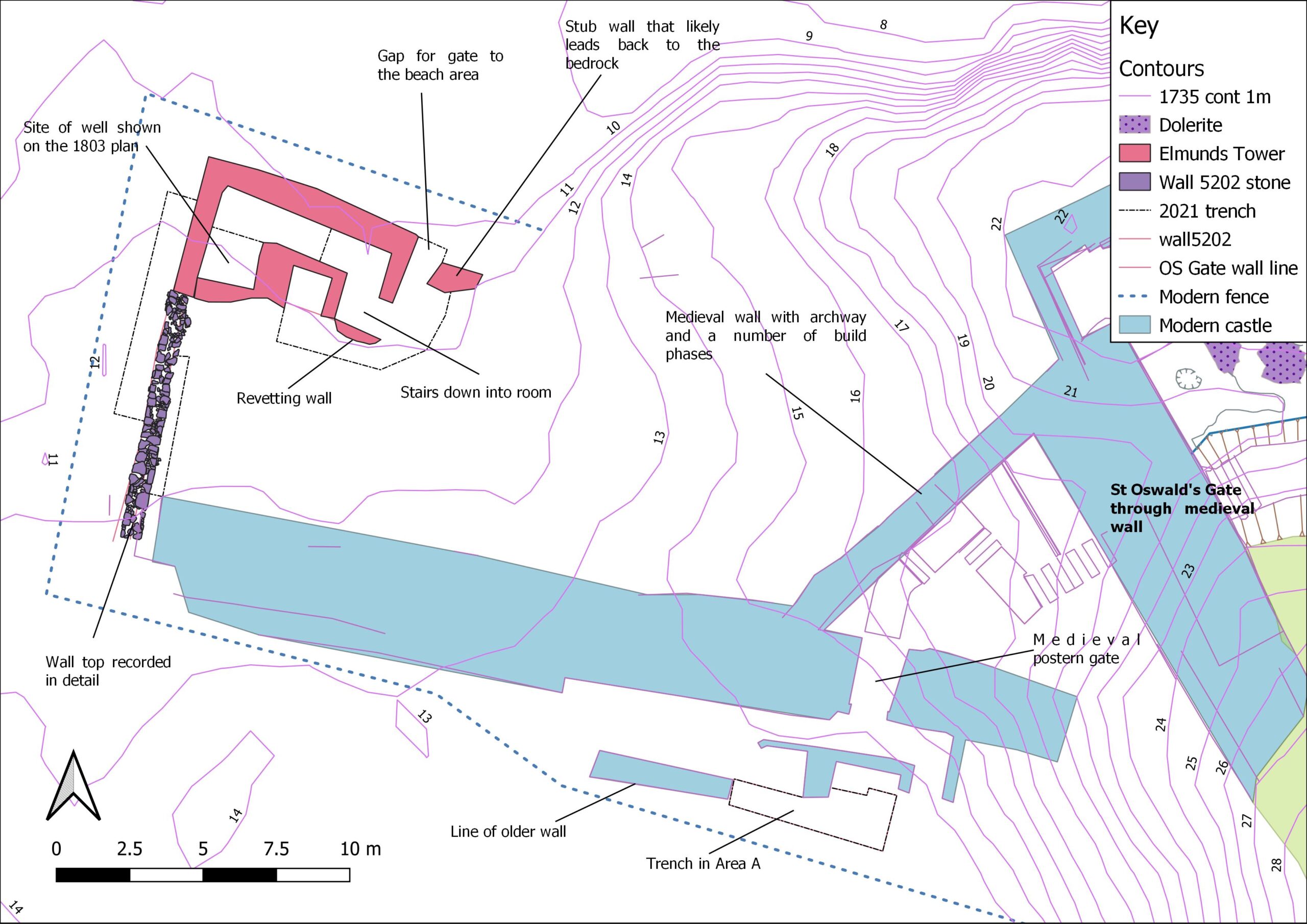
St Oswald’s Gate and the outworks beyond lie in the area of the original entrance to the castle. It is very likely that the siege castle (named Mal Voisin in the Anglo-Saxon Chronicle) was built close to this gate in AD 1095. When the main access was re-sited, the entrance here remained as an important postern, perhaps serving a small adjacent harbour immediately to the north of the site. This area now forms the BRP’s main investigative focus. The outworks consist of strong walls enclosing a trapezoidal area with the Tower of Elmund’s Well, with a more recent wall and postern to the west.
Map depicting current area of excavation (Base map Crown Copyright/database right 2022. An Ordnance Survey/Edina supplied service).
The outworks at St Oswald’s Gate are a rare case at Bamburgh as they have not been subject to extensive rebuilding in the post medieval period. Other than the reconstruction of the tower as a cottage, the outworks represent an astonishing window into mostly unaltered medieval fabric still standing at Bamburgh.
Aerial shot of Elmund’s Tower and suspected medieval well location.
Work to Date
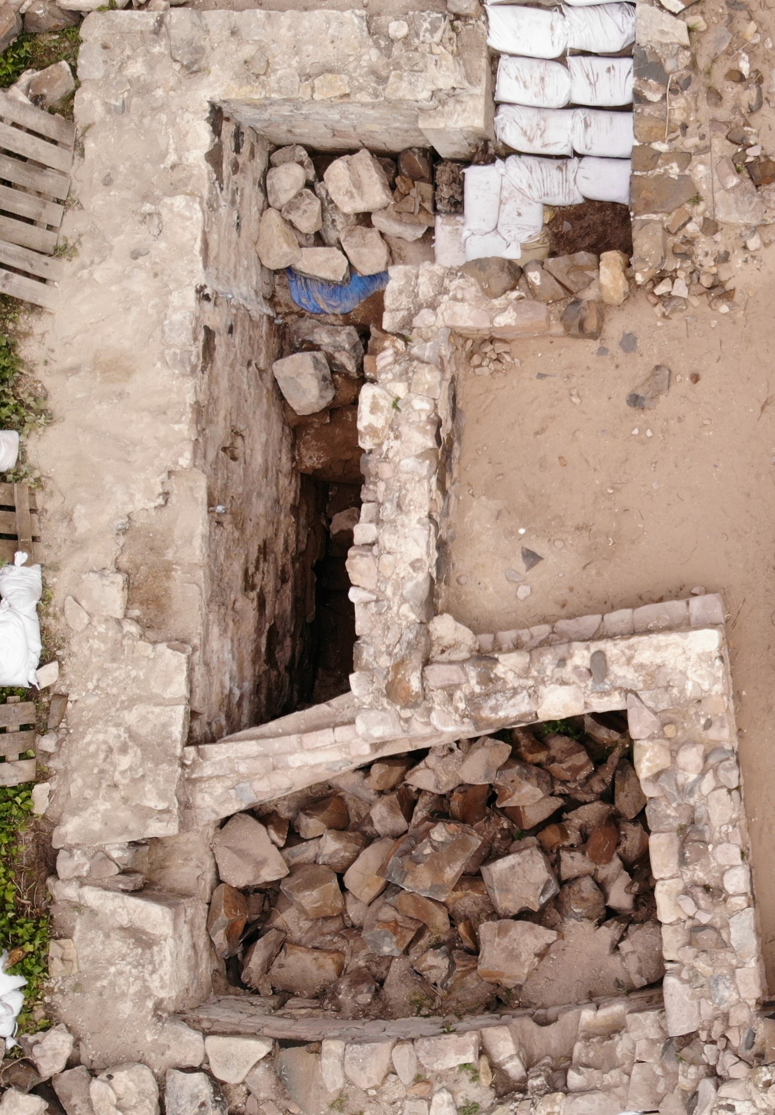
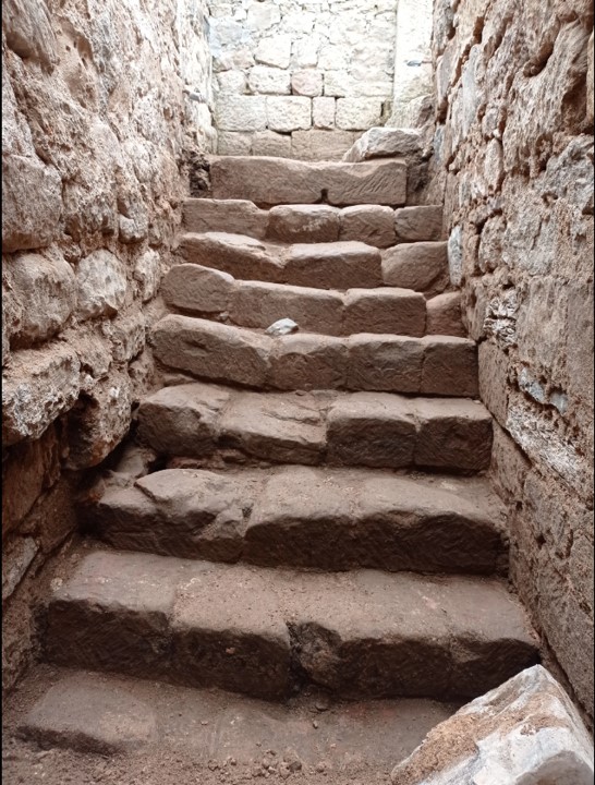
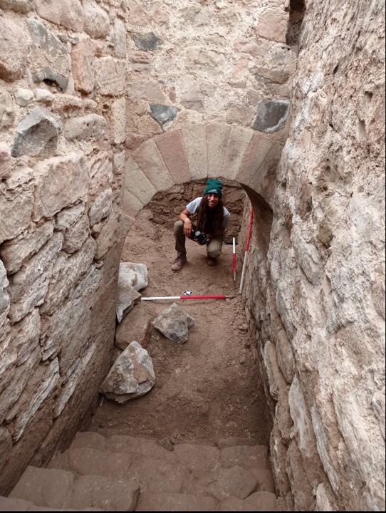
Recent investigation by the BRP has revealed that a substantial structure still survives below ground. This is in the form of an L-shaped corridor and steps down into the room that is thought to be the tower basement that contained the well. The presence of two splayed narrow windows appears to further indicate that this is part of the medieval Elmund’s Tower. Our primary aim this year is to continue to reveal the full extent of the tower and identify any remains of the well depicted on the 19th century survey.
Steps down into the room that is thought to be the tower basement that contained the well.Arch into the well room of the tower
What will the Castle Studies Trust (CST) Funding be used for?
There are two primary aims for the CST funding:
The first is to contextualise our recent excavations at Elmund’s Tower through geophysical survey (GPR and Magnetometry) and to undertake a masonry survey of the castle’s associated extant outworks. This will include using photogrammetry to create a 3D model of the standing outworks and internal structures of Elmund’s Tower. The survey will be undertaken in conjunction with a metric survey of the structures outlines. This work is currently underway and we look forward to sharing the results with the CST. You can follow our progress on our blog: https://wordpress.com/post/bamburghresearchproject.wordpress.com
The second focus for the funding will be on disseminating our discoveries to the wider public. We will install signage for visitors, who cannot currently visit this area of the castle with a QR code for the 3D model, granting online access to Elmund’s Tower and the wider outworks over the winter period. This information will also be replicated and enhanced with the creation of a new webpage on the Bamburgh Castle website. Alongside these permanent additions we will continue to share our work through our blog and social media.