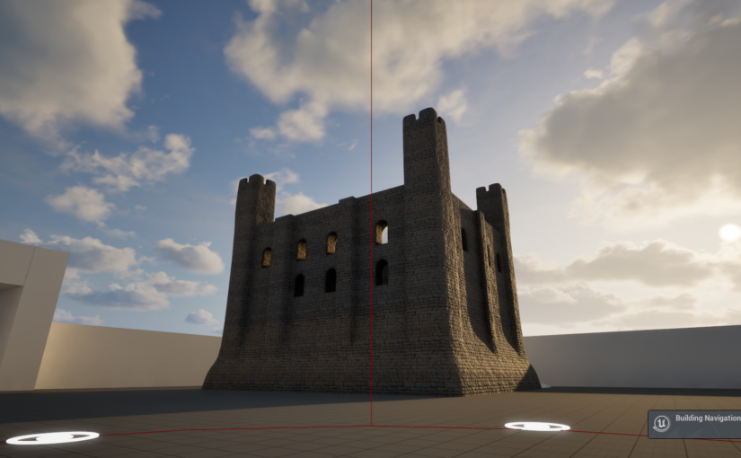
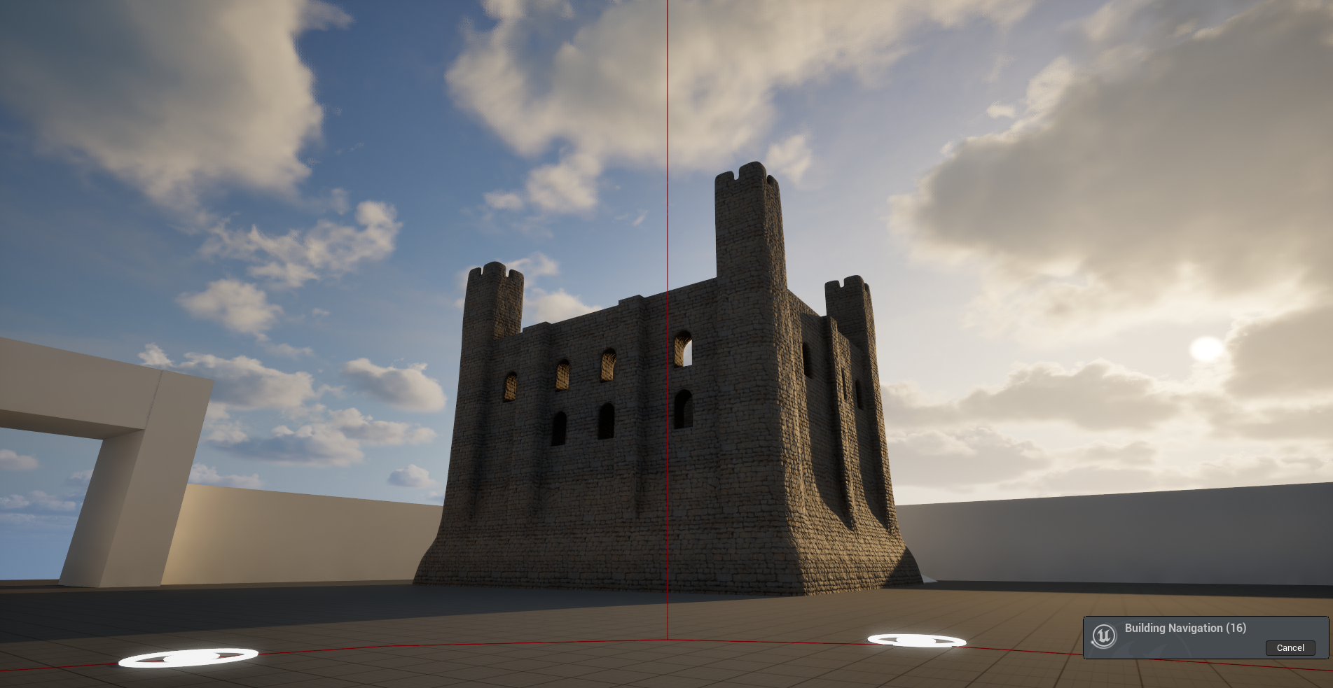
Project lead of the Canterbury Castle Visualisation project, Dr Katie McGown, gives an update on how the project is progressing.
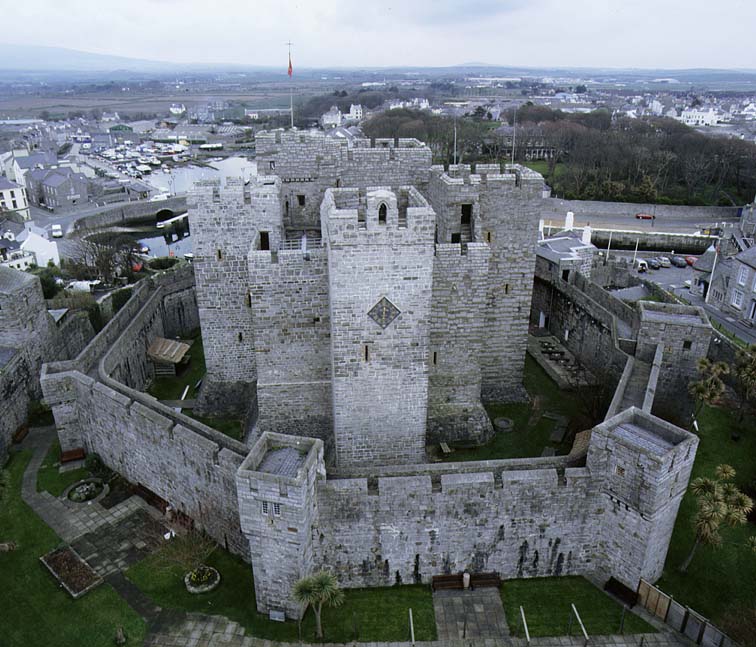
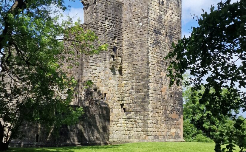
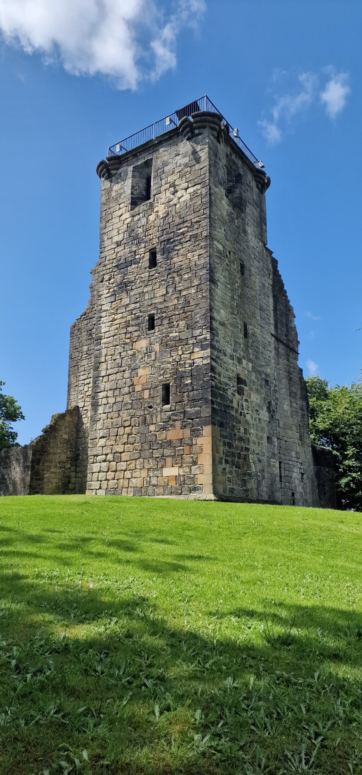
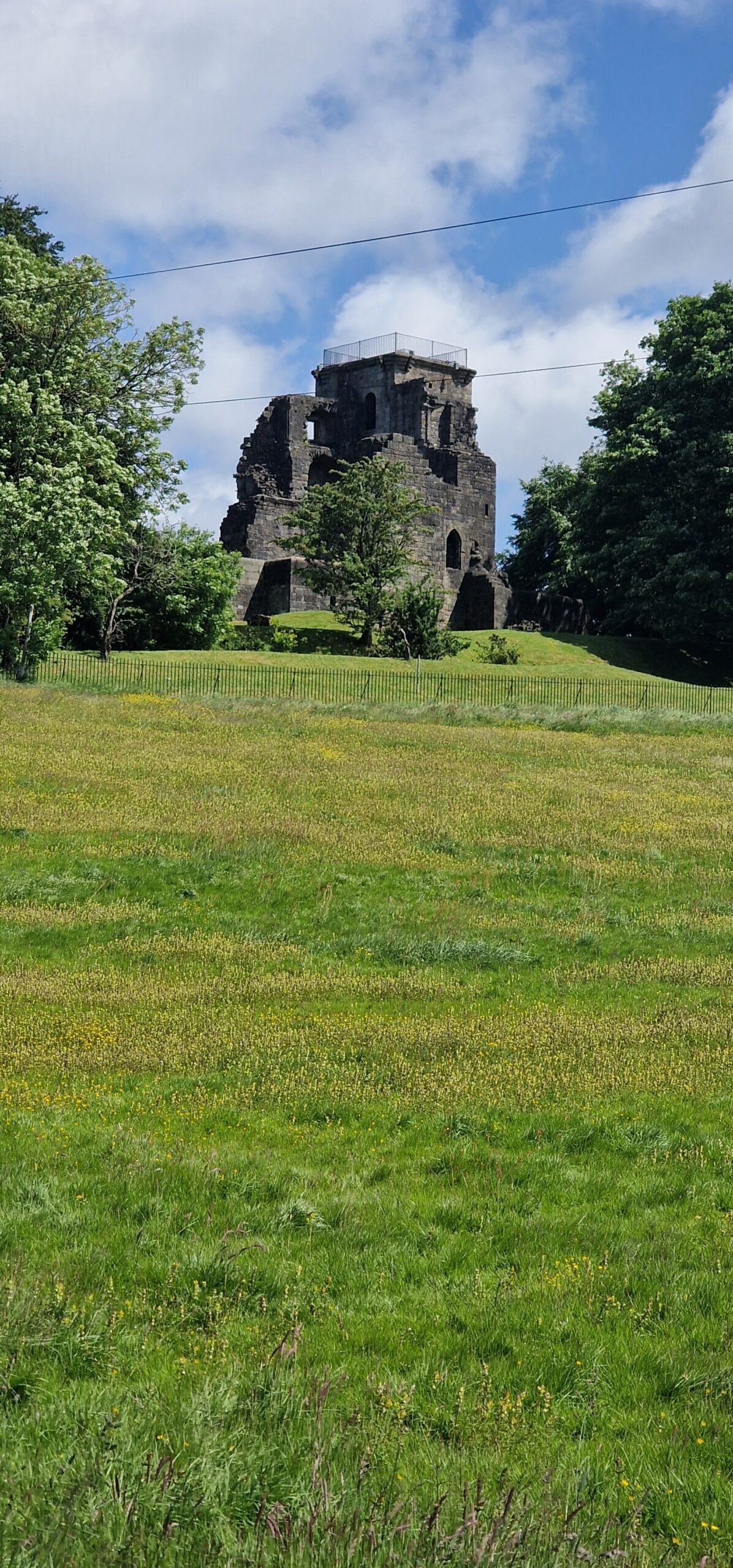
The Visualising Canterbury Castle project is in the process of producing a new digital reconstruction of Canterbury Castle’s Norman keep. In our last post we discussed the first of a series of co-design sessions we have organised to allow a range of expertise and stakeholders to help us develop and interrogate the model we are producing. However, this is not the only way we are collating information to inform our understanding of the built structure.
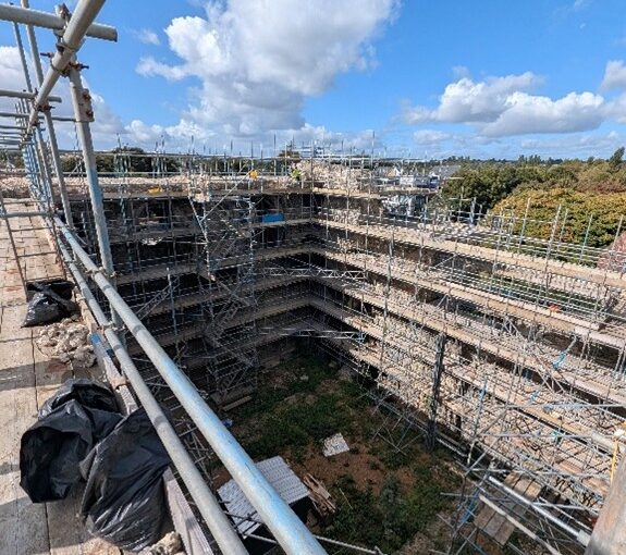
Canterbury Castle has been closed to the public since 2018, and as it is currently being refurbished, the walls are obscured by scaffolding. Because of this, initially we drew heavily on Excavations at Canterbury Castle (Bennet et al, 1982) published by CAT, which features elevation and plan drawings. This helped us map out the size and shape of the building for the early stages of the model. However, over the course of the development of the project, questions have arisen about areas of the building which are no longer extant, and we’ve had to piece together information from other sources, and crucially, by visiting other castles.
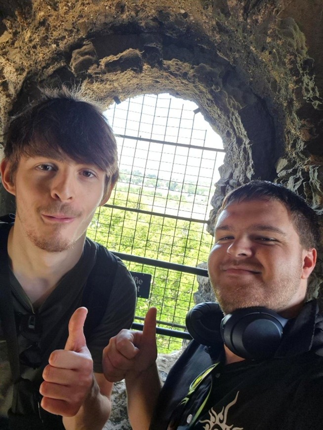
After the first co-design session our student interns, Ethan Serfontein and Joseph Seare, and Technical Lead, Mike Farrant, were invited to Rochester Castle by Dr Jeremy Ashbee, Head Properties Curator, English Heritage. Through visiting a similar structure, the team gained greater understanding of both the defining features of a Norman keep, and how we can draw evidence from the building to inform our reconstruction.
Joseph (l) and Ethan (r) from the project team visiting Rochester Castle (copyright Dr Katie McGown)
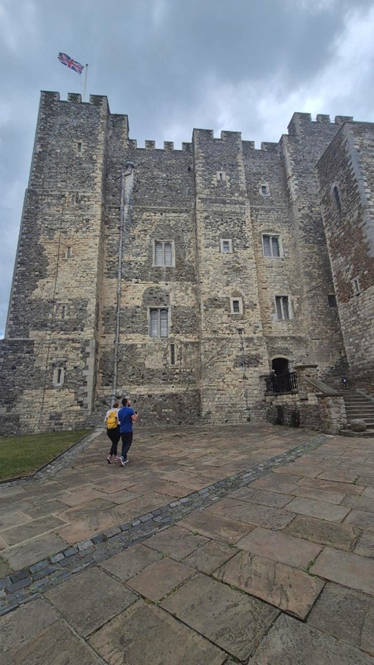
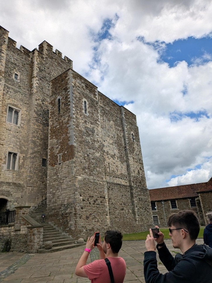
As we continued to develop the digital reconstruction, questions began to emerge about the structure of the outer staircase and how this would look. This is a difficult question to answer given that the structure no longer exists. However, the team were able to develop a better understanding of how the space might have worked by comparing their observations in Rochester with a visit to Dover Castle. Professor Alan Meades, Dr Cat Cooper, Mike, Joseph and Ethan went down to Dover and spent time discussing the differences between the three Royal Norman castles in Kent, and documenting features like the staircase. Dover Castle also gave the team the opportunity to appreciate the lovely Norman interiors.
Dover Castle Keep copyright Dr Katie McGownChristchurch, Canterbury visualising team visiting Dover Castle, copyright Dr Katie McGown
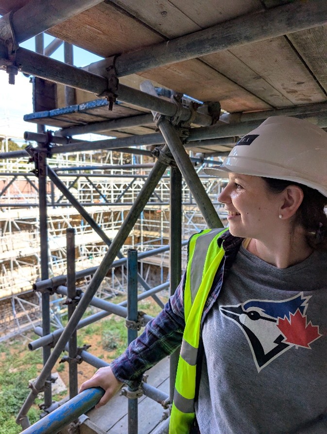
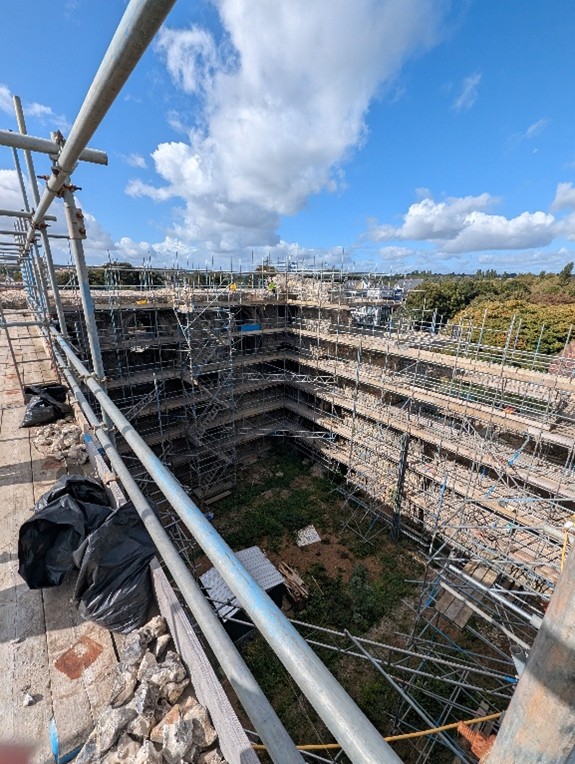
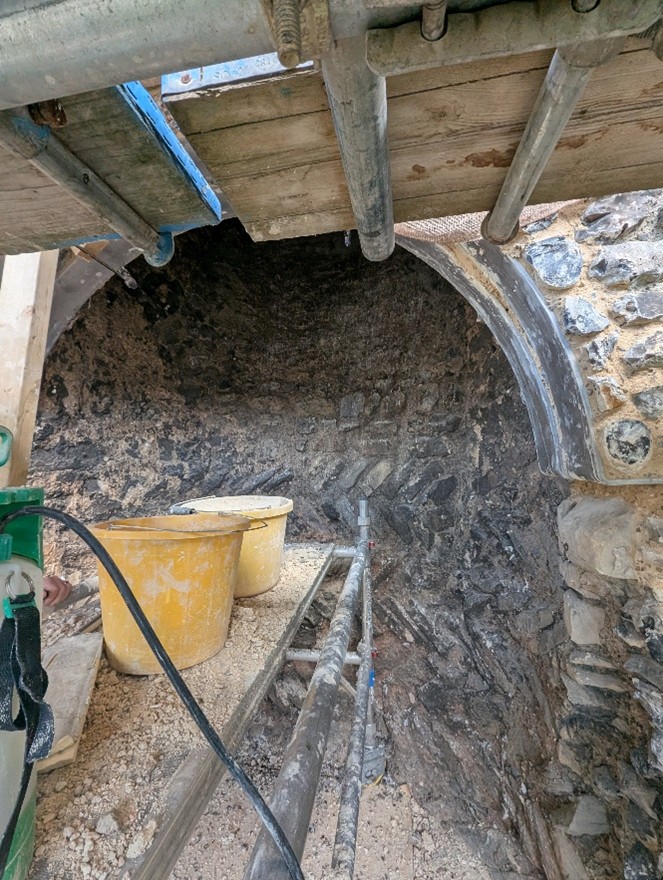
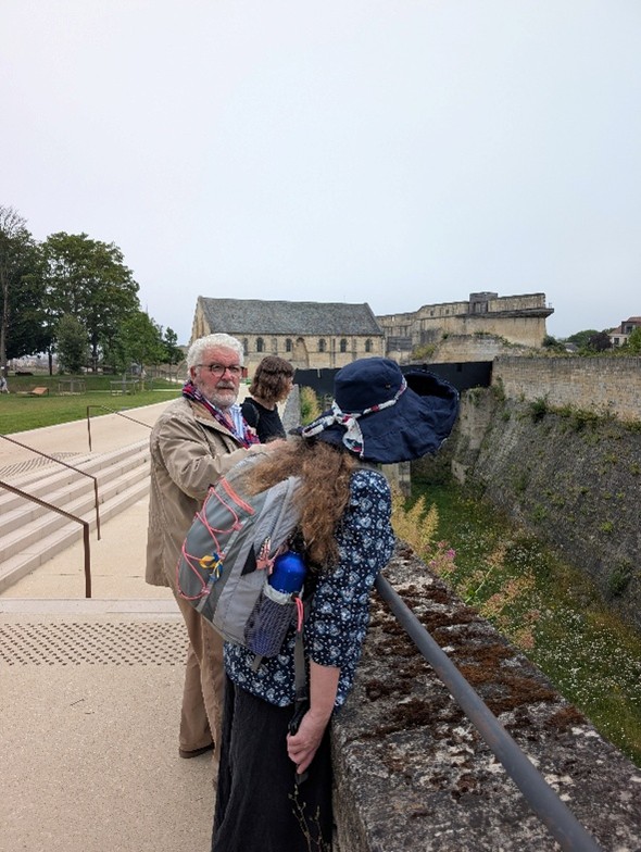
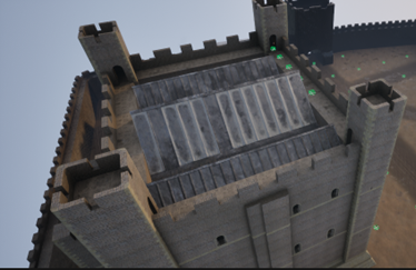
Recently, we were able to visit Canterbury Castle, courtesy of Lian Harter from Purcell and Alison Hargreaves from Canterbury City Council. Dr Katie McGown and Cat donned high vis, hard hats, and steelies to climb the scaffolding. This visit allowed them to think about sight lines around the city, but also observe important details such as this stunning herringbone brickwork in the fireplace. The tour also gave us incredible insight into the refurbishment of the keep, and how that process might be incorporated into the eventual curriculum resource that accompanies the project.
Dr Katie McGown visiting Canterbury Castle refurbishmentCanterbury Castle refurbishment copyright Dr Katie McGownHerringbone fireplace at Canterbury Castle, copyright Dr Katie McGown
We’ve also been thinking more broadly about how the project might fit into wider activities in development for the 2027 European Year of the Normans. Professor Leonie Hicks, Cat and Katie travelled to Caen Castle to see about possible collaborations for work at the site, and were delighted to have a detailed tour led by Curator Jean-Marie Levesque around the delicate foundations of Caen Castle’s Norman keep. The team also took the opportunity to see the Bayeux Tapestry prior to its voyage to the British Museum.
Caen Castle, copyright Dr Katie McGownCanterbury Castle visualisation team with Caen Castle curator Jean-Marie Levesque
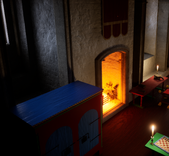
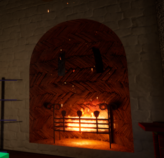
Each of these visits informs the development of the digital reconstruction. For example, following the visit to Canterbury Castle, the fireplaces were adjusted to showcase the herringbone brickwork.
Original visualisation of Canterbury Castle fireplace prior to visit. Copyright Canterbury Castle Visualisation Canterbury Castle Visualisation updated fireplace with herringbone stonework. Copyright Christchurch Canterbury Visualisation
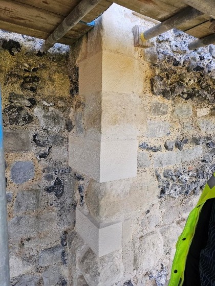
Similarly, being able to see the refurbishment of Canterbury’s Caen stone has informed the exterior of the digital reconstruction.
Refurbishment of Canterbury Castle with new Caen stone, copyright Dr Katie McGownCanterbury Castle Visualisation updated to include Caen stone noted in the castle restoration, copyright Christchurch Canterbury Visualisation team
The team has one final visit planned to Norwich Castle before the end of the project, and we are looking forward to continuing to develop our understanding and appreciation of Norman keeps.
Dr David Caldwell, formerly of the National Museum of Scotland, has just had the results of his excavations at Finlaggan in the 1990s published by the Society of Antiquaries of Scotland. Here he describes one of the more unexpected outcomes of the dig.
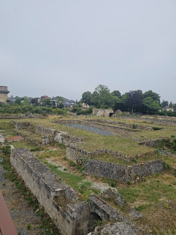
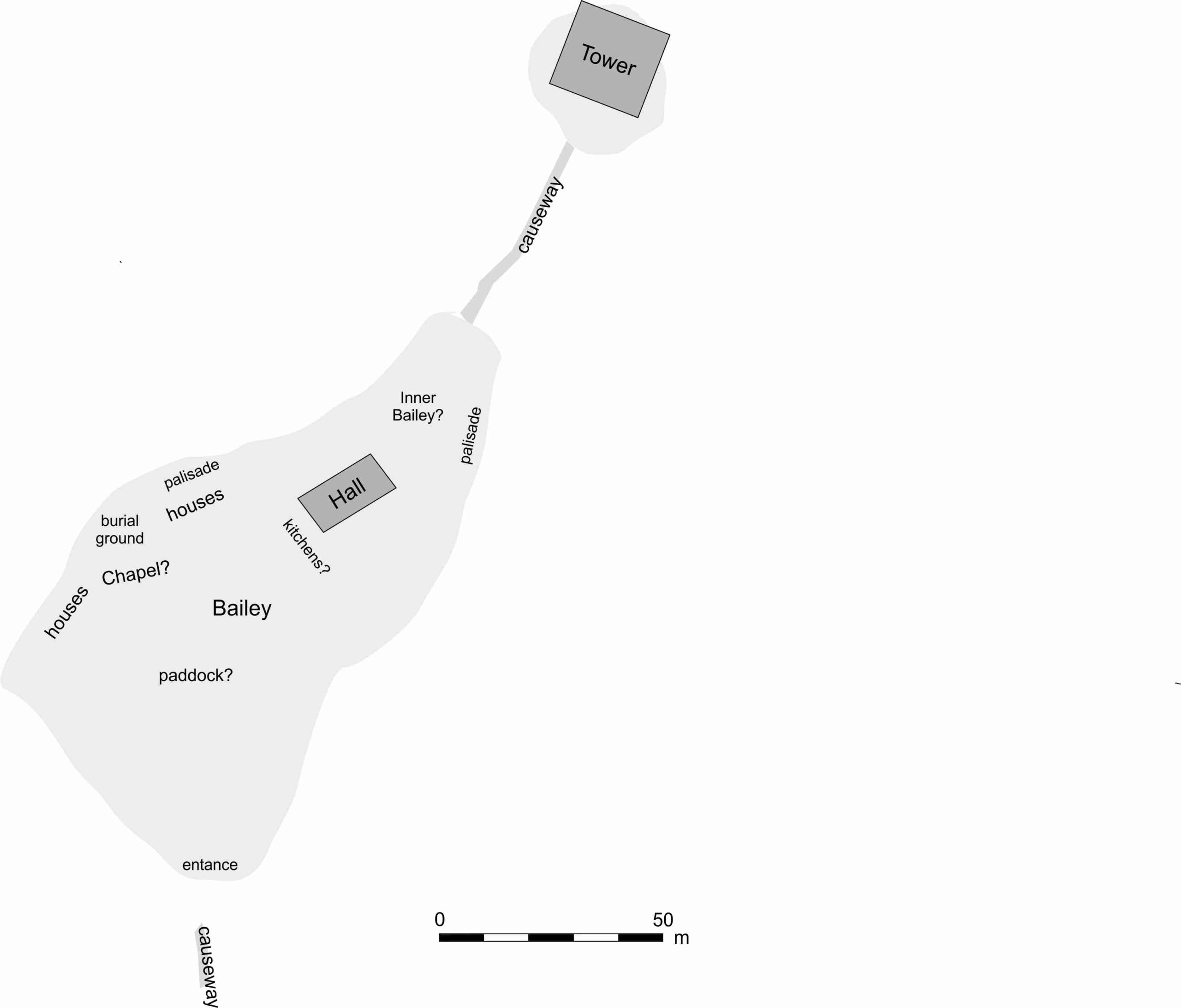
The main aim of the Finlaggan archaeological project was to shed light on a place believed to be the centre of the Lordship of the Isles in the fourteenth and fifteenth century. It consisted of two adjacent islands, Eilean Mór (the large island) and Eilean na Comhairle (the council island), in a freshwater loch in the island of Islay off the west coast of Scotland. The site was described as a castle by the Royal Commission in their inventory of ancient monuments published in 1984, but as the author pointed out to friends and colleagues on many occasions there was no such thing. Such documentary evidence as there was suggested an unfortified, palatial complex and that is what was discovered in the excavations, a residential and administrative centre for a large lordship spanning the Western Isles and parts of the mainland, a place where new lords were made and a council of the Isles met.
Plan of Finlaggan Castle, copyright David Caldwell
But the practice of archaeology is rarely straightforward and is always likely to produce evidence contrary to the predictions required for research proposals. So it turned out that the later medieval residence of the lords was a successor to a castle of twelfth- and thirteenth-century date. There was a substantial, 19m square masonry tower occupying all the available space on Eilean na Comhairle, connected by a stone causeway to Eilean Mór. Only tantalisingly small glimpses of castle structures could be seen here under later structures, but enough to be clear that there was a timber palisade enclosing structures including a great hall, kitchens, houses and probably a chapel. Another stone causeway provided access from the lochside.
This was clearly a major castle but no records of its existence have been found in the admittedly meagre documentary records for this part of the world. We do not know for sure who might have had it built, nor do we have any certainty about what it might have been called. Eilean Mór was known in later medieval times as the island of St Finlaggan, referencing the cult of a saint, Findlugán, a contemporary of St Columba. It is possible that that dedication is no earlier than about 1300 and has resulted in the loss of an earlier placename of Scandinavian type. Most of the surrounding farm names are Gaelicisations of Norse names.
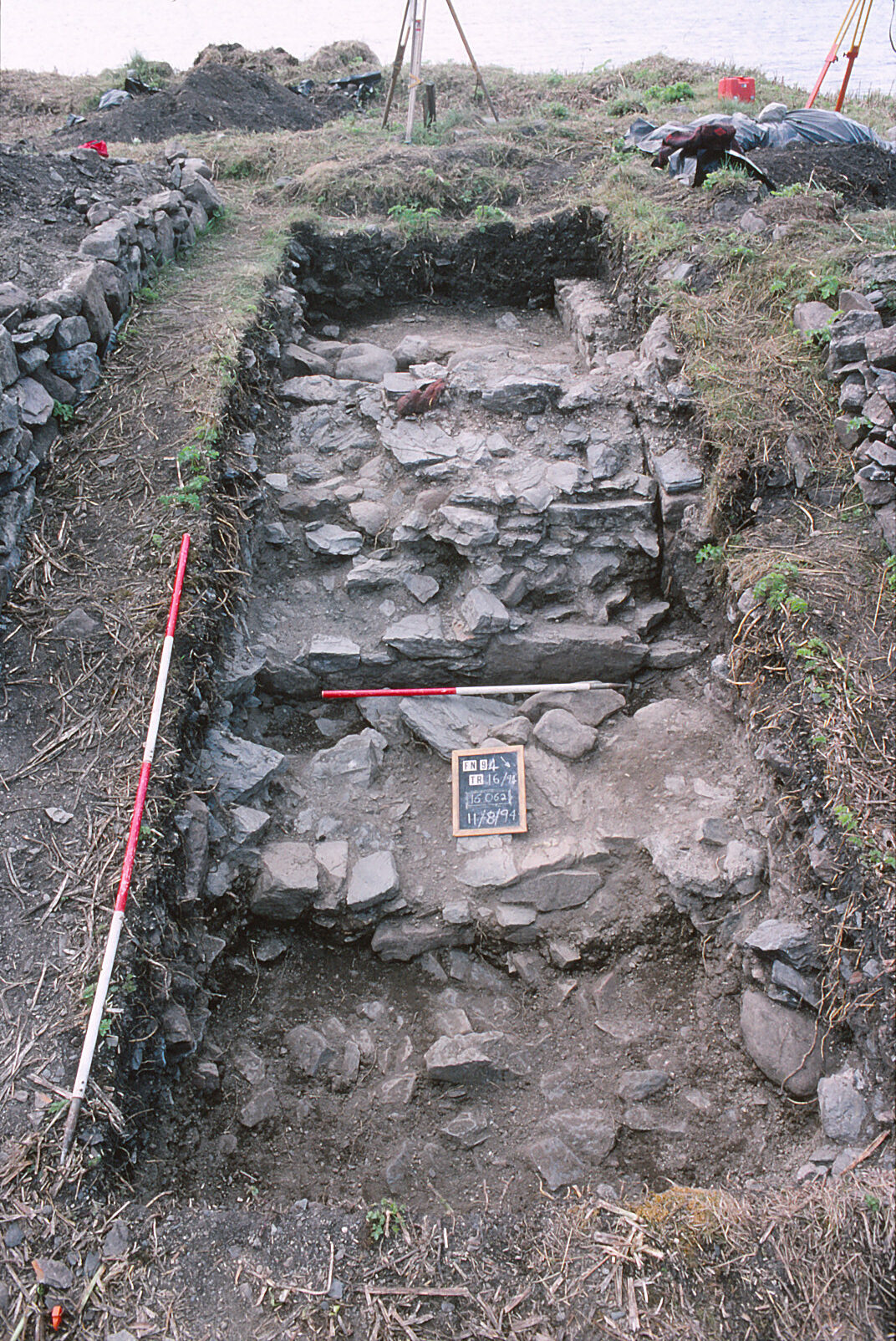
Finlaggan Castle excavation (1994): looking west over plinth 16062 and castle wall 16025B. A fragment of red sandstone marks the side of the much denuded castle entrance. Copyright David Caldwell
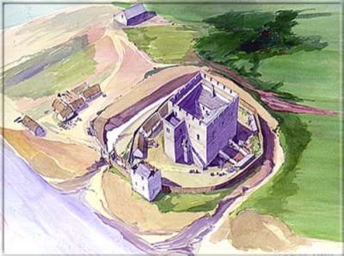
In terms of size the Finlaggan tower is similar to the one that forms the core of Castle Rushen, now believed to have been built for Rognvald Godredsson, King of the Isles from 1188 to 1226. The masonry, with coursed, long and low rubble blocks, is similar to Finlaggan. King Rognvald is clearly a contender to be considered the builder of the Finlaggan tower. The writer, however, believes that a more likely candidate for this role was Rognvald’s rival for power in the kingdom, Ranald son of Somerled, also regarded as a king. He was the ancestor of the MacDonalds and according to later traditions, a crusader. There are two main reasons for this identification.
Reconstruction drawing of the core of Castle Rushen when first built, Isle of Man, copyright Manx HeritageCore of Castle Rushen today, copyright Manx Heritage
First, a substantial midden deposit in the loch adjacent to Eilean na Comhairle was sampled and produced ample evidence for fine dining by a lordly or kingly household in the thirteenth century and many sherds of medieval wheel-made pottery. There is no evidence of such ceramics being manufactured anywhere in the Isles apart from the Isle of Man and so all the wheel-made pottery recovered at Finlaggan can be regarded as imports, almost all from the Scottish mainland. No Manx pottery has been recovered from Finlaggan or other Hebridean sites and no Scottish medieval pottery has been recorded from the Isle of Man. Somerled and Ranald held lands in Scotland and their activities and rise to power can be seen in the context of a Scottish push westwards that resulted in the acquisition of all the kingdom of the Isles in 1266. The Chronicle of the Kings of Man and the Isles maintained at Rushen Abbey in Man maintained that the breakup of the Kingdom of the Isles into two parts was down to Somerled’s sons.
Second, it appears that Finlaggan was an important thing (assembly) site, arguably the predecessor of Tynwald in the Isle of Man. The actual place for meetings would have been on Eilean na Comhairle. The erection of a massive tower on top of it has the appearance of a hostile act by an incoming power. It is possible that the main Islay residence for the dynasty of kings based in the Isle of Man, ancestors of Rognvald Godredsson, was Dùn Ghùaidhre. The folk of Islay are clear that it is named for King Godred Crovan who died in Islay in 1095.
The Archaeology of Finlaggan, Islay is available from the Society of Antiquaries of Scotland’s online shop, with a 20% discount for Fellows of the Society. Dr Caldwell will also be delivering a free public lecture on Finlaggan on Saturday 29 November in Edinburgh and online.
Project leads Paul Pattison and Esther van Raamsdonk give an update on how their project on transcribing and translating of the Seventeenth Century survey by a Dutch Engineer of 22 castles and fortifications.
Now we are reaching the end of our research project – Transcribing and Translating SP9/99: A Seventeenth-Century Dutch Survey of 22 English Castles and Fortifications – we wanted to share a little more about the process of coming to grips with this engrossing manuscript.
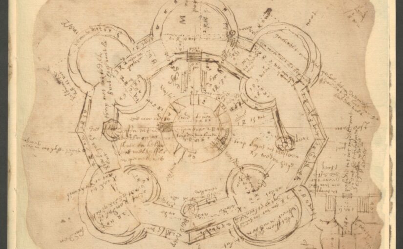
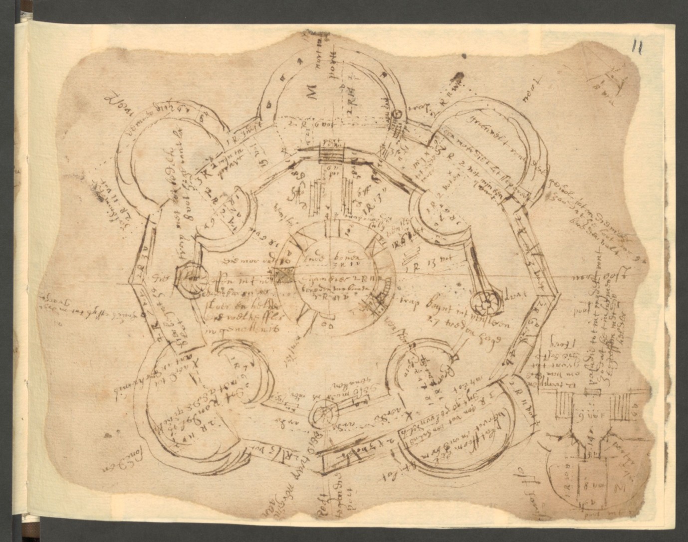
A brief bit of context: the National Archives holds an anonymous manuscript, currently undated but certainly early seventeenth century, which contains a survey of at least 22 English castles and fortifications. This survey was carried out by a Dutch engineer, who clearly spent considerable time in England, as he has adopted several English words (albeit with idiosyncratic spellings). Because of the linguistic and material challenges – the unorthodox Dutch, the difficult handwriting, and the bad condition of the paper – it has never been transcribed and translated. The value of understanding the manuscript, however, is clear. The survey outlines the condition of the castles and fortifications at the time; it provides early modern names of buildings and their elements, some of which are now lost. It also provides suggestions for improvement, some of which we know have later been realised. We can now relate these improvements to the suggestions of the survey. More will be said in due course about some of our findings concerning what we can learn about the history and development of the 6 particular castles that we have now transcribed and translated – Sandown, Deal, Walmer, Dover, Sandgate and Camber – but here we wanted to elaborate a little on the fun and challenges of transcription.
The engineer was from the Low Countries. It is difficult to pinpoint exactly where, but it was likely the southern end of the Netherlands, as the language does not follow the more standardised version of Dutch that by that time flourished in the North. Beyond the language, there is no punctuation in the document, not even a full stop. Almost all text is in phrases; there are no complete sentences; frequently verbs are missing. It reads like a list or a summing up of the engineer’s thoughts as he examined the sites. However, the content is also careful and precise, noting measurements, directions, costs and uses, all accompanied with skilful drawings and plans.
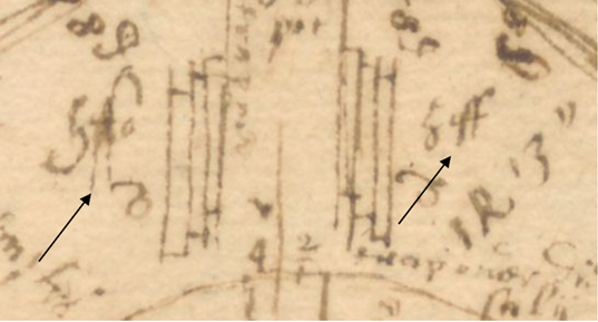
We will give you here two examples from Camber Castle. We have included the engineer’s full sketch plan here but will zoom in on the central keep. Having spent several months with this engineer and his handwriting, it can feel like we know the man quite well. He was often in a rush. This is visible in the way he sometimes repeats the same word in a row, and the density of abbreviations used. In the early modern period, abbreviations were common, and were themselves often standardised. For example, yt for that, or Sr for sir. These could be marked in several ways, but most often in either superscript or with a line above the word. Our engineer liked to break with tradition and places a characteristic C above a word. In my years working as palaeographer, I have never come across this, so we can reasonably conclude that this engineer was not formally trained. That is to say, he did not go to university; for most of the early modern texts that we work with, the authors had received a formal education and conform to the ‘rules’ of writing, but our engineer had worked out his own system of noting deviations. In a similar break with tradition, he uses the C symbol in three ways: to mark an abbreviation, to flag where he has made a mistake, or to indicate an English word and that he does not know how to spell it. Which one of these is the case for individual words is up to us to find out.
Image of Camber Castle from manuscript SP9/ 99. Copyright Paul Pattison
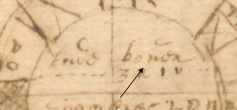
In the image below, there is a good example of the difficulty of these abbreviations or deviations. In the keep of Camber castle, there is written ‘ende boven, …… 3r 1v’. We know there is something strange going on with the word ‘boven’ because of the symbol C. To confuse matters further, this handwriting uses the same letter for v and n, and its e is often written as an o. We therefore assumed that this word would be an abbreviation of ‘benen’ (sometimes written as benéen), meaning ‘beneden’, which is Dutch for beneath or underneath. However, after working on several castles, it did not make sense that he would be talking about a roof beneath a room, and we therefore had to revisit all instances of benen and realised in some cases it had to be ‘boven’, meaning above. In this case the C symbol merely signifies the confusion between n and v, that the engineer himself clearly also suffered from.
Camber Castle image close up from SP9 / 99. Copyright Paul Pattison, National Archive Kew
To give an example of the engineer’s haste, or possibly enthusiasm, we can turn now to the marks just above the word ‘boven’ in the previous image. As is clearly visible from the full photo of Camber castle, this was a gifted draftsman. Camber Castle is certainly not the most technically difficult of the castles in the manuscript, but, as ever, his attention to detail and scale is impressive. The care he took in the drawing itself is not always present in his annotations, presumably because these were in draft form. As a result, the distinction between what is part of the drawing and what are notes that were added later is blurred. In the below image on the left, there is a strange mark which can be transcribed as ‘hffo’. This is not even close to an early modern Dutch word. The h also misses its characteristic full loop in the bottom curve. We thought it might be an abbreviation, although the C-symbol is not present, or some sort of mark highlighting an element of the building. It was only after we went over the full transcription several times again, that we realised he had misspelled ‘hoff’, like the word on the right, meaning ‘courtyard’ in Dutch. In his rush he had jumbled the order of the letters and not fully closed his h.
Camber Castle image close up 2 from SP9 / 99 at National Archives, Kew. Copyright Paul Pattison
These moments of breakthrough are rather exhilarating. Most of the transcriptions and translations that we have made still have some outstanding ‘curiosities’ to be solved. However, as a result of these idiosyncrasies or oddities, we have been drawn very close to the material and grappled with all aspects of it: the material history, the background of the engineer, the process of surveying these castles and fortifications, and the long history of repair. We are now in the process of puzzling over the new information the survey has brought to light and how it fits with what we already know about these buildings. We look forward to disclosing further updates here, hopefully in fully legible modern English.
In the first of two articlesDr Cristian Clarkson, Heritage Consultant at Simpson & Brown takes a look some of the work she has doneat various castles during her time with the firm.
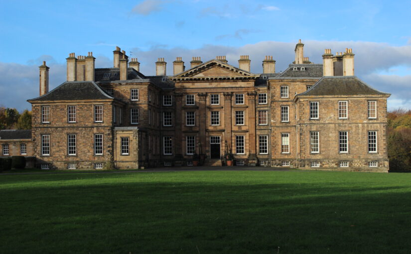
The exterior of Dalkeith Palace is easily accessible to visitors, standing within a popular country park south-west of Edinburgh. Its interiors, however, have been largely hidden away since its construction for Anna, Duchess of Buccleuch, in the very early eighteenth century, and it has been relatively little-studied. Duchess Anna commissioned a radical remodelling of Dalkeith Castle, the Buccleuch family seat, from architect James Smith, and the family used the house for two hundred years. Clumsily converted for office use in the 1970s, and then used as the study-abroad centre of the University of Wisconsin from the 1980s, the building was vacated in 2021 and new uses are currently being evaluated by the Buccleuch Estate. Simpson & Brown completed a conservation plan for the building in 2024, one of the key questions of which was how far there were remains of Dalkeith Castle within the Palace, and what that castle was like.
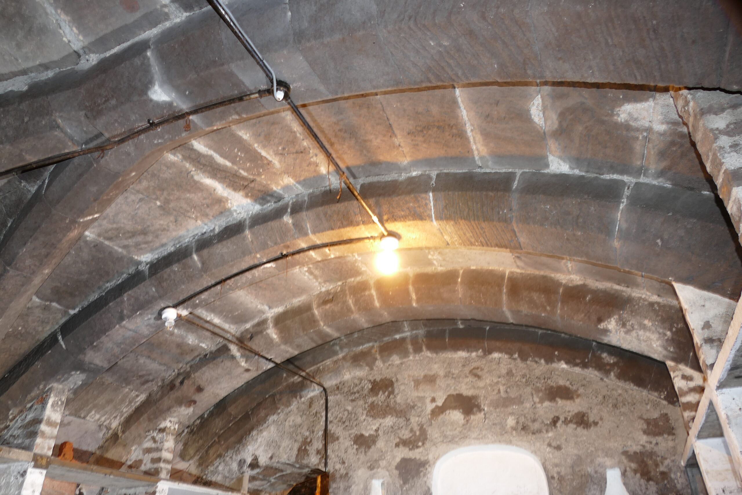
Dalkeith Castle probably originated in the fourteenth century as a Douglas fortification, and was expanded by the 4th Earl of Morton in the sixteenth century. It was bought by the Scotts, then Earls of Buccleuch, shortly before the Wars of the Three Kingdoms in the seventeenth century, and passed to Anna Scott in 1661 when she became Duchess in her own right. The fact that there is at least some medieval fabric remaining at Dalkeith is clear: there is a rib-vaulted basement room in the north range, at the centre of an area of very thick walls. There is also an asymmetry in the Palace’s plan: although the south entrance front is highly regular, the west range in fact meets the north range at an angle, immediately suggesting the re-use of earlier fabric. Several locked voids in the plan of this range suggest the historic presence of a kitchen with large flues which were blocked by James Smith.
Basement of North Range at Dalkeith Palace, copyright Simpson Brown
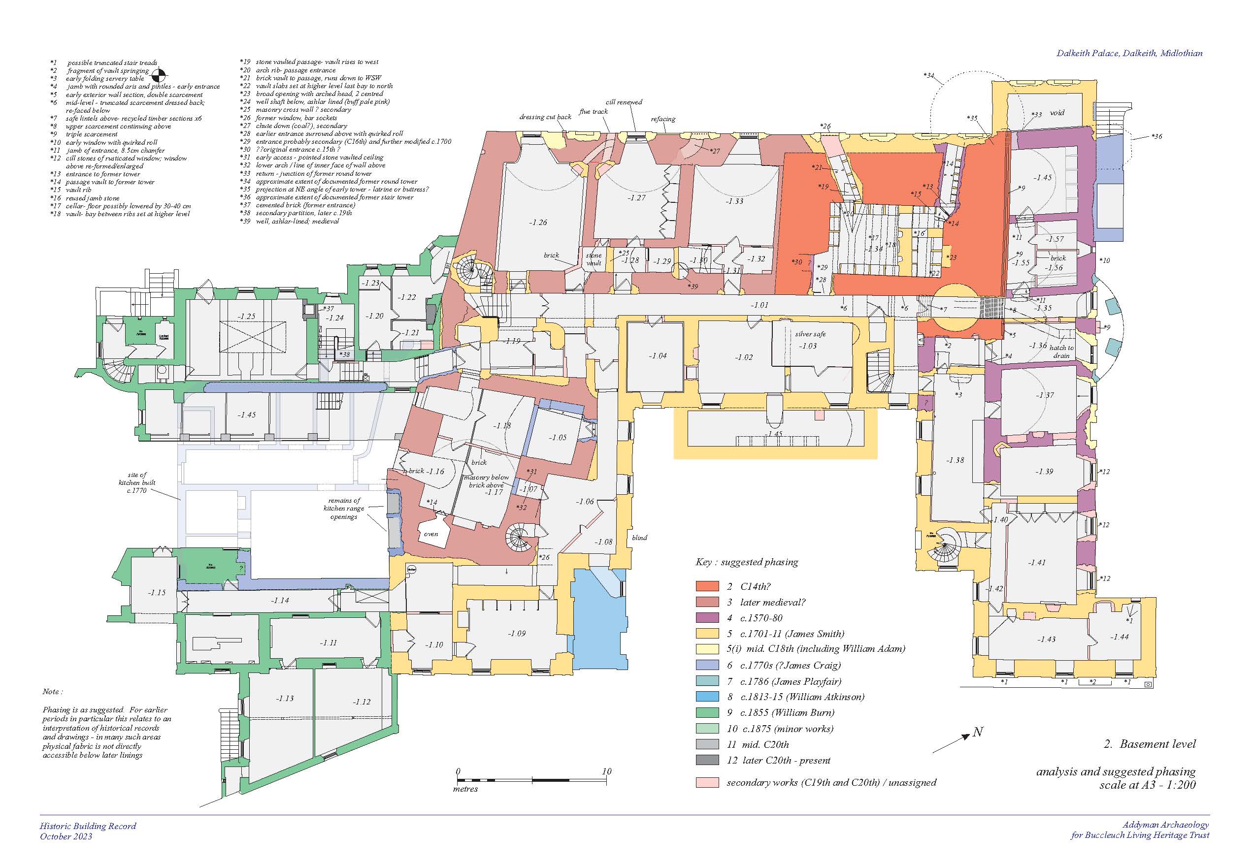
There are two key images of the historic castle: Slezer’s engraving (incorrectly labelled Glamis in his publication), and an unnamed, undated plan held in the Buccleuch collection which shows one storey of the castle. Slezer shows a castle built around two courts, with the inner court on three sides replicating the plan of the existing Palace. At the north-east corner, a tower over three or four storeys with bartizans and pedimented window-surrounds stands over the existing vaulted cellar, while a low range to the west must contain the historic kitchen. On the east side, there is a regular range which stands where there are barrel-vaulted cellars in the present Palace. The plan shows a turnpike stair where there are now empty round rooms at each level in the former stairwell, and a scale-and-platt stair on the same location as the existing state stair. At the north-east corner of the castle there is a projecting round tower shown which almost survived to the present building, as later documents show.
Phased Plan of Dalkeith Palace, copyright Simpson Brown
Little is known about the castle’s interiors, but there was something to be gleaned from the huge wealth of documentary evidence relating to Duchess Anna’s rebuilding. The Buccleuch archive, held partly in the National Records of Scotland, includes many receipts for work on the building. Although the majority of these are for the new eighteenth-century fabric, there are some which relate to cosmetic renovations on the old castle: the Duchess travelled north after decades in London to stay in the castle, meet James Smith and sign contracts for the rebuild, and the house needed some work in advance of her stay. Invoices for plastering list the rooms of the castle, including ‘the great painted room’, as well as ‘the King’s room’ with an adjacent study; these entries are arranged by floor and give some suggestion of the location of these rooms within the building. They also give clues as to which rooms were retained: one room listed is known as the ‘stone hall’, and a room with this name appears consistently in invoices for work in the new building as well. It is probably the vaulted room above the kitchen, used by the steward.
We also examined a series of design development drawings by James Smith, in which he helpfully shades fabric to be retained in the new house. None of these drawings are exactly as-executed (William Adam’s plans in Vitruvius Scoticus are the closest to the finished house), but show that initially Smith hoped to raze the old palace and eventually retained a great deal of the castle at basement and ground levels. There appear to have been particular difficulties around the north-east corner, where the plans were to retain the existing round tower; this was not carried off in the final design and would have made an interesting companion-space to the exquisite neighbouring ‘picture closet’ with its elaborate parquet floor and painted mirror by Jakob Bogdany. Smith also workshopped an option where the original re-entrant stair would be retained with a new branch down into the entrance hall, but this was not executed.
The Buccleuch archive also contains the details of a court case between Smith and the Duchess after the completion of the building, which reveals some of the decision-making process behind the retention of castle fabric. The Duchess complained that the building was poorly constructed, with cracks in the walls and chimneys which smoked: Smith blamed the Duchess for insisting that he keep old masonry rather than building anew. Presumably her primary motivation was financial, but her letters reveal a certain sentimentality for her childhood home, which she left after her father’s death and before her marriage to the Duke of Monmouth. She wrote to a friend that he might think she was extravagant in fitting out her new house with marble, ‘but it is to shew you I do not Dispyse my old Castle.’
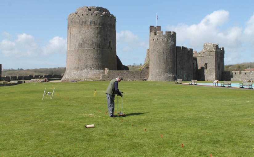
Buildings archaeologist, Neil Ludlow, gives an update of the work that has been donesince the Trust funded two projects at Pembroke Castle.
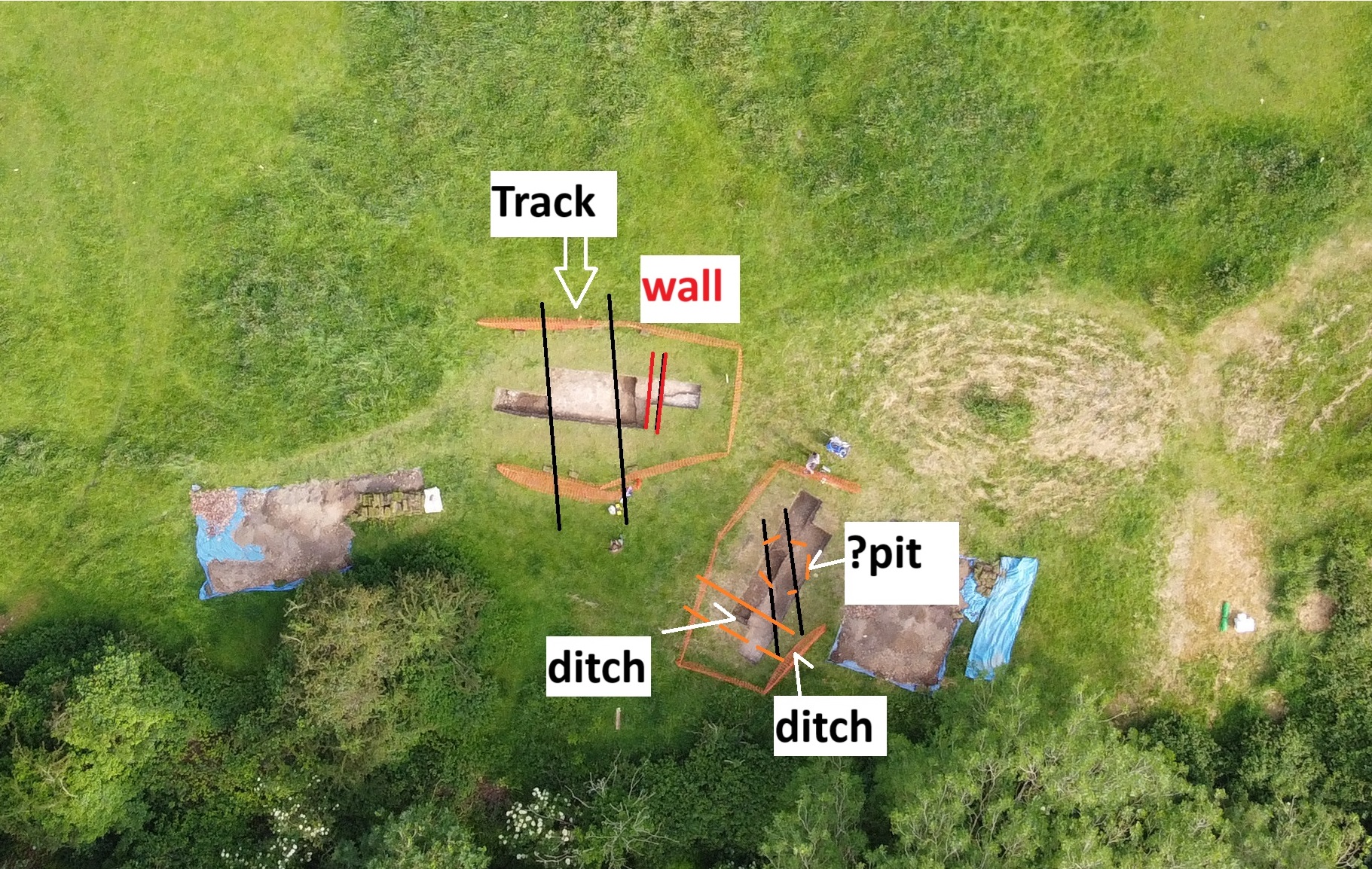
Two CST-funded projects, in 2016 and 2018, looked at a late-medieval building complex in the outer ward at Pembroke Castle (Day and Ludlow 2016; Meek and Ludlow 2019). All above-ground remains of the buildings have gone, but vestiges of walling are marked here on a plan from 1787, while a drawing from 1802 appears to show a surviving doorway. The buildings were part-excavated in the 1930s, but sadly without record. However, the presence of walls, floors and stairs was noted, and a cess-pit from which was retrieved a Limoges-enamelled bronze fitting of late thirteenth/early fourteenth-century date. The wall-lines show as strong parchmarks in dry summers (see Fig. 1).
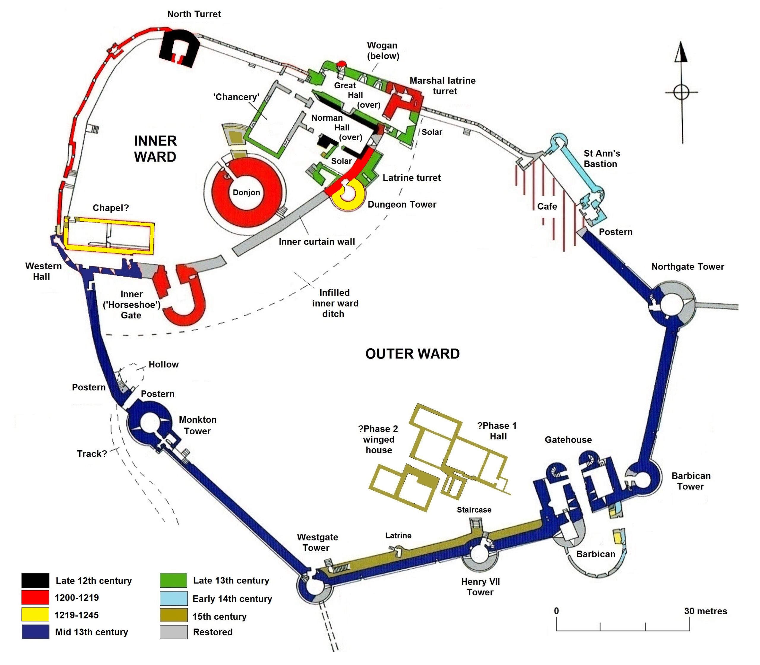
Figure 1: Phased plan of Pembroke Castle, copyright Neil Ludlow
The spacious outer ward was added to Pembroke Castle in the 1240s-50s, and appears to have been an entirely new enclosure. It was not ditched, the limestone bedrock instead being levelled as a platform to receive the curtain walls. And a flanking tower, the so-called ‘Dungeon Tower’, had been built against the inner curtain only 20 years previously, implying that it was still a forward line of defence. Moreover, it subsumed part of the town as at Swansea (Glam.) and Ludlow (Shrops.). Geophysics by Dyfed Archaeology in 2016 suggested it was largely an empty space, perhaps intended for ‘civil’ assembly, military gatherings, pageantry/display or leisure – or perhaps all four. By the early fourteenth century, it appears to have contained a garden and it may always have been perceived as ‘gentrified’ space, rather than seeing the kind of purely functional use that is normally ascribed to outer enclosures (Ludlow 2017).
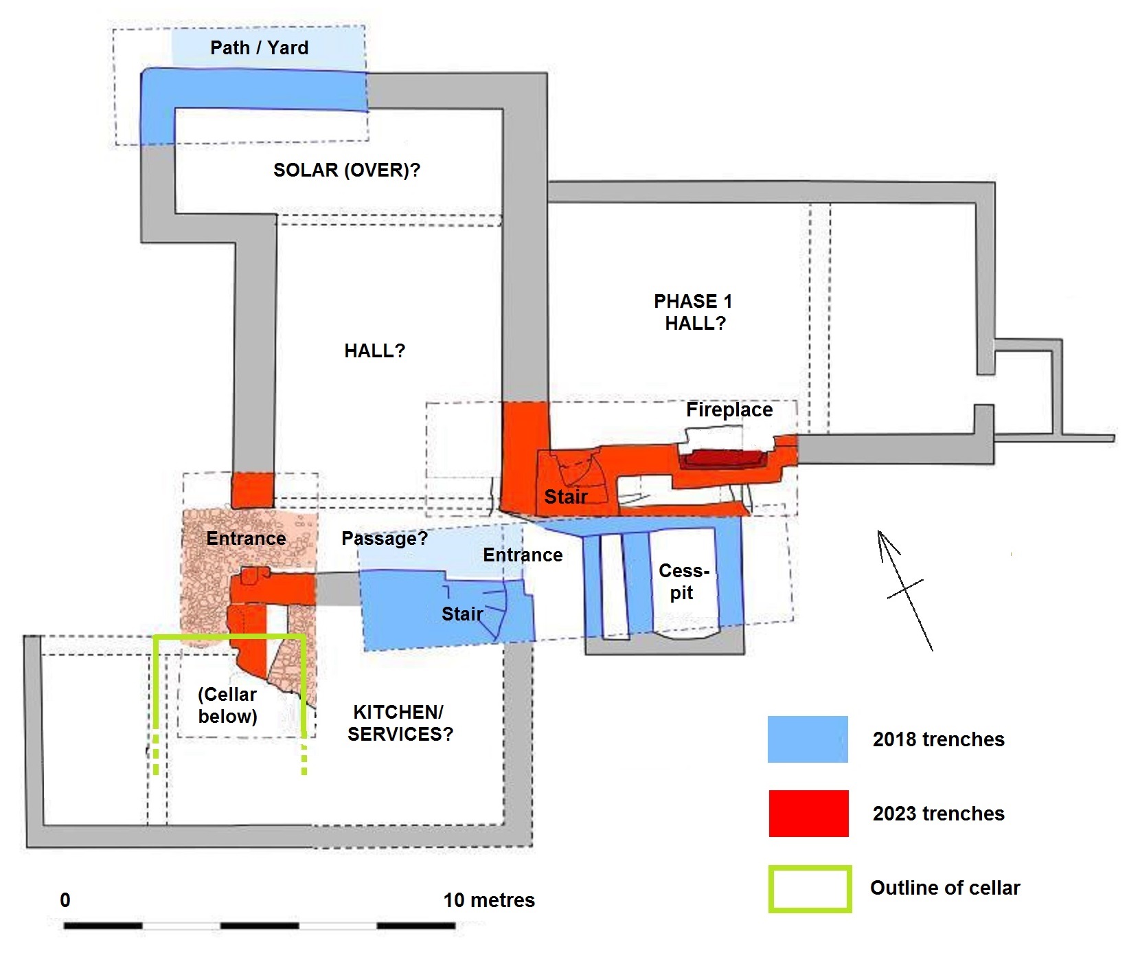
So the complex, which was clearly substantial, was interpreted as high-status and residential: taken along with the parchmark evidence, the geophysics appeared to indicate a substantial, winged hall-house, with a possible yard to the southeast conjoined with a further, smaller building. Two trenches were excavated across the winged house in 2018, by Dyfed Archaeology, revealing walling, a helical mural stair, and the cess-pit exposed in the 1930s (Fig. 2). The excavated area was limited and the full layout of the complex not revealed. Neither was close dating evidence forthcoming.
Two more trenches were dug in 2023, again by Dyfed Archaeology but this time funded by the Pembroke Castle Trust (Poucher 2025). They produced a couple of big surprises. Firstly, a cellar was revealed beneath the southern wing of the hall-house. And what had been interpreted as an open yard, to the southeast, was revealed to be another roofed building, with a lateral fireplace in its south wall (Fig. 2). The base of a further mural stair was exposed in the same wall. The physical relationships showed that this building pre-dated the winged hall-house, but close dating evidence was again slight.
Figure 2: Plan of the excavation trenches over the hall-house (adapted from Poucher 2023). The winged house to the southwest (left), overlying a cellar, appears to be secondary to the open Phase 1 Hall.
While only four small trenches have been dug, and the site is still very little understood, we can perhaps propose a conjectured sequence. Its scale and location show the house to have been an elite structure from the first. On current evidence, it appears to have begun as a large, free-standing hall, with an attached, storeyed unit at its southwest end overlying a barrel-vaulted cellar; the latter is of a regional form similar to late-medieval cellars that still survive below properties in Pembroke town. This end unit was subsequently replaced with, or adapted into, a winged house that was apparently self-contained: it appears to have comprised a central space (another hall?), associated with the cess-pit and flanked by storeyed wings; the upper floor of the southern wing was accessed via a helical stair.
Comparison with similar buildings, and the sparse dating evidence, suggests both phases are fifteenth-century. By this time, the domestic buildings in the inner ward had a history of neglect, coupled with an increasing burden of administrative and penal machinery. The outer bailey was both quieter and emptier, and had perhaps always seen ‘elite’ forms of use, with at least one garden (later two); understandably, it might have been preferred for seigneurial residence. A similar development occurred in another caput castle, at Montgomery, where a mansion house was built in the outer enclosure during the 1530s.
And the Pembroke house appears not to have sat in isolation. The south curtain wall has, at some period, been doubled in thickness with over two metres of masonry applied to its internal face (Fig. 3). This has long been regarded as a Civil War measure against artillery (see King 1978, 120), but an earth fill was normally chosen for this purpose, while the thin-walled mural passage lies on the exposed external face. I suggest this thickening belongs instead to the fifteenth century, to create a broad ‘promenade’ at parapet level. The use of parapets as promenades has been suggested at a number of castles, from the twelfth century onwards: they provided a viewpoint from which a lord could show off his domain to distinguished guests, while offering scope for high-status recreational use – particularly by women. The Pembroke parapet is approached by two staircases in the thickened section, both of a somewhat ‘processional’ nature. One, a mural stair, is long and straight, while the second wraps around the Henry VII Tower as a double flight of persuasively late-medieval form, and was clearly designed to be seen; it is not obviously military (Figs. 1 and 3). Lying immediately south of the house, it is accompanied by a second ornamental feature – a projecting porch, leading to a latrine within the wall-thickening. This porch, like the thickening, has traditionally been assigned to the Civil War period (King 1978, 94 and n. 75), but in overall form it is not unlike the corbelled oriels seen in later fifteenth-century domestic work (Figs. 1 and 3). Though substantially restored, all these features respect surviving physical evidence; together with a second garden mentioned in a source from 1481-2, they appear to represent a prestige suite of ‘eye-catchers’, clustered around and associated with the hall-house. It is likely, too, that use of the latrine itself was restricted by status and/or gender. The infilling of the inner ward ditch may belong to the same period, to create more seigneurial space.
Figure 3: The outer curtain wall from northwest, showing the double flight of stairs around the Henry VII Tower, to left, and the latrine porch at centre. The parchmarks of the hall-house are visible at bottom left.
Three candidates had the resources to build on this scale. It is possible that the Phase 1 hall was built by Humphrey Duke of Gloucester, earl of Pembroke 1413-47, for his personal use. His political influence was in decline by 1441, and he may have intended to use Pembroke as a regular residence, far from his powerful opponents: he appears to have already built a smaller hunting-lodge for himself, just over the river from the castle at Monkton. If so, it is possible that the Phase 2 winged house was added by Jasper Tudor, soon after he acquired the earldom in 1452, in anticipation of occasional visits and to announce his ‘arrival’ among the leading aristocracy. It might not, however, allow enough time for the promenade to be built: after 1454, and until 1461, the Wars of the Roses forced him into more-or-less permanent residence at Pembroke, but in an environment that may militate against such overtly domestic work. Jasper seems moreover to have rarely visited Pembroke after the war, when he concentrated on his favoured castles at Sudeley and Thornbury in Gloucestershire. It may then be that the winged house and promenade were added by the Yorkist leader William Herbert the elder, who held Jasper’s forfeit lands between 1461 and 1469. His work at Raglan in Monmouthshire, where the castle was transformed into a magnificent palace, shows him to have been an ambitious builder.
King, D. J. C., 1978 ‘Pembroke Castle’, Archaeologia Cambrensis 127, 75-121.
Ludlow, N., 2017 ’Medieval Britain and Ireland, Fieldwork Highlights in 2016: Pembroke Castle outer ward – gentrified space and Tudor Mansion?’, Medieval Archaeology 61/2, 428-35.
Ludlow, N., forthcoming ‘Two baronial castles in Pembrokeshire: Picton and Pembroke’, Journ. British Archaeological Association 178.
Meek, J. and Ludlow, N., 2019 ‘Pembroke Castle: archaeological evaluation, 2018’ (report by Dyfed Archaeological Trust for the Castle Studies Trust: see – http://www.castlestudiestrust.org/docs/Pembroke_Castle_Evaluation_2018_FINAL.pdf.
Chair of the Friends of Crookston Castle, David McDondald and Historic Environment Scotland’s Dr Hazel Blake look forward to the community geophysical survey days that are starting on Friday that the Trust is funding.
As Glasgow celebrates its 850th anniversary, the Friends of Crookston Castle are proud to be contributing to the city’s story with a major new heritage project.
Re-established in 2024, our volunteer-led group exists to care for and celebrate Glasgow’s only surviving medieval castle, Crookston.
Crookston Castle copyright Friends of Crookston Castle
Once surrounded by ancient woodland the Castle is now encircled by twentieth-century housing. It has stood as a landmark in the life of generations of local people, but many of them do not realise just how deep its history runs.
That’s why we’re excited to be launching Echoes from the Earth – Crookston Castle’s Hidden Stories, supported by the Castle Studies Trust.
At the centre of the project is a three-day geophysical survey, the most comprehensive investigation of the site in decades. The survey will use three techniques; gradiometry, earth resistance, and ground-penetrating radar to build a picture of what lies beneath the castle grounds and the surrounding area.
With the help of Historic Environment Scotland, local volunteers will be trained to use the archaeological equipment providing our partner schools with a unique learning experience, while boosting the skills of early career archaeologists and local students. Crookston Castle is an unusual stone castle built around 1400 within earlier earthworks constructed in the 1100s. It is the only surviving medieval castle in the City of Glasgow and is in the care of Historic Environment Scotland (HES; Crookston Castle | Public Body for Scotland’s Historic Environment).
The site is a well-known local landmark and has an active ‘Friends of Crookston Castle’ group from the local community who value the monument as an important part of their historic environment. Working in partnership with the ‘Friends’, the archaeological survey team at HES will be undertaking geophysical survey at Crookston Castle. This has two main objectives – firstly to understand more about what may lie below the ground surface, and secondly to provide experience of geophysical survey to the Friends of Crookston and support them in finding out more about their monument.
At any stone-built castle, it is inevitable that impressive standing masonry is a focus of attention. But these were monuments that underwent changes and development, perhaps because of war damage or as needs changed, and may be one aspect of a much longer span of activity on the site. So, there may be more to them than immediately meets the eye. The planned gradiometer, earth resistance and ground penetrating radar surveys (see here for more information on these techniques) will provide views of what archaeological remains lie below the ground surface. We hope this will provide more information about the history of the castle, enriching the stories that the remains can tell us and informing future management of the site.
Crookston Castle, copyright Friends of Crookston Castle
Crookston Castle matters to the local community, and that is one reason why it is important to HES to be working with the ‘Friends’ to better understand their monument. By providing experience of geophysical survey and the interpretation of the results, we have an opportunity to share experience and knowledge and together contribute to a better understanding of the site now and in the future.
Geophysics is exciting because you never know what may pop up in the survey data, lurking unsuspected under the ground surface! But there are already two potential areas of interest that we know should benefit from survey. One area to the south of the stone castle may contain medieval activity, while to the west there is what may have been the original western entrance. Both areas will be an initial target for the geophysical survey, with flexibility to target further areas across the site.
Crookston Castle is valued by its local community. It is a great opportunity for HES, as the national publicly funded body for the historic environment, to be able to engage directly with the Friends and support them in their interest in the monument.
If you would like to get involved with the group, get in touch at Crookstoncastlefriends@gmail.com and follow them on Facebook.
So, if Crookston is close to you and you’d like to get involved in the project, get in touch or follow our progress on our social media and help us unearth the history and stories of a site that even after all these years still has secrets to share and that continues to surprise us, inspire us, and to remind us that the past is never quite as far away as it seems.
Project lead of the 2022 project Dating the Medieval Towers of Chalkida, Greece, Dr Andrew Blackler, gives an update on how work on the project has progressed.
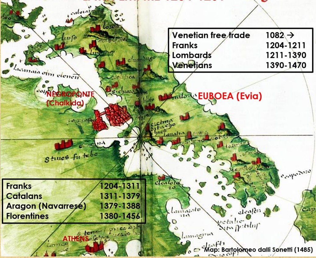
Mention the Acropolis to anyone and they will probably immediately identify it with Greece. Yet the Norman invasions of Greece just fifteen years after the battle of Hastings are almost unknown. Few will know too that the magnificent horses adorning St Mark’s Basilica in Venice were pillaged from Constantinople in 1204, and that much of Central Greece and its islands were ruled for nearly three hundred years by a succession of western adventurers from as far away as Catalan Spain, until the region’s annexation by the Ottoman empire at the end of the fifteenth century. This is simply illustrated in the figure below, based on a map of Central Greece by the Venetian cartographer Bartolomeo dalli Sonetti c.1485. at a time when Athens was just a small provincial town whilst Negroponte was a major city.
This is the background to the five-year survey of the hinterland of medieval Chalkida (Negroponte) on the island of Evia (Euboea), which I was invited to join by Professor Joanita Vroom of the University of Leiden Dr Alexandra Kostarelli of the Ephorate of Antiquities of Euboea in 2020 – the first major archaeological survey in Greece to focus exclusively on the medieval period. Initially, times were tough as the COVID shutdown and lack of funding restricted our work, but slowly our team established a track record supported by sponsorship from institutions such as the Castle Studies Trust (2022).
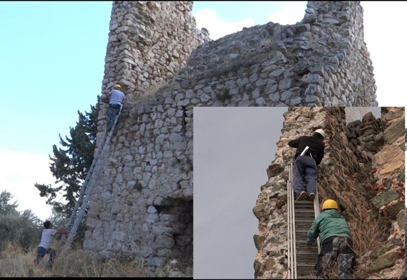
This project, in conjunction with the National Centre of Scientific Research laboratory at the University of Athens, undertook the radiocarbon dating of sections of wood taken from within the walls of a group of medieval towers, a ubiquitous feature of the region. It was very successful. For the first time we were able to conclusively prove that the more than one hundred towers, that once stood on the island, were not built immediately after 1204 as part of a colonial process of control and exploitation, but during the fourteenth century, probably to protect local villages against pirate attack from the sea, an endemic problem of the era.
Figure 2: Taking wood samples from a tower, copyright Dr Andrew Blackler
During five years of work over the summer months our team of over thirty specialists and student volunteers has now recorded all the known medieval monuments of the region. Using intensive surface survey techniques and trial excavation trenches, evidence from ceramic, coin, glass, iron, fauna and bone finds is slowly allowing us to reconstruct a picture of the medieval life of the region. Trading links have also been identified east as far as the Black Sea and Palestine, and west to other centres around the Mediterranean. More recently, we have attracted major sponsorship and are now undertaking geophysical surveys to identify structures hidden under the earth, digital reconstruction of selected monuments and have even instituted a second phase of radiocarbon dating. In parallel, specialists have been investigating the medieval archives of the Republic of Venice and Ottoman administrative records held in Istanbul. A detailed report of the results of the first two years’ survey campaigns can be found at https://poj.peeters-leuven.be/content.php?url=article&id=3293423&journal_code=PHA&download=yes
I will leave you with a final thought: the medieval world, despite the slow pace of travel, was much more inter-connected than people generally believe. Two examples illustrate this. Many know that Harald Hardrada, king of Norway and the last great Viking, invaded England in 1066, and was killed at Stamford Bridge just weeks before the battle of Hastings. Few realise that he made his fortune fighting for over ten years in the elite Byzantine Varangian Guard, and that this had probably helped fund his claim to the Norwegian throne. Recent analysis of finds in the British Museum from Sutton Hoo also suggests that Anglo-Saxon mercenaries were even fighting alongside the Byzantine emperor Justinian in Asia Minor as early as the sixth century. This is the sort of international research that the ‘seed capital’ provided by the Castle Studies Trust has spawned over the last three years.
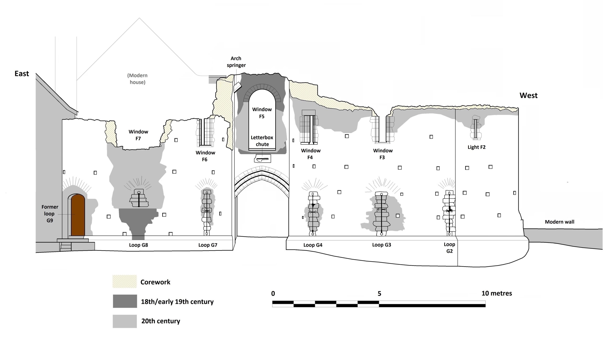
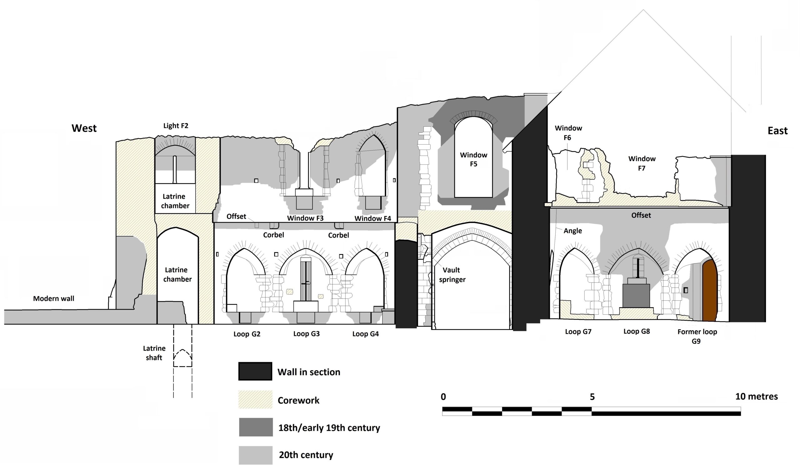
In the second half of 2024, Heneb’s Phil Poucher with the support and expert analysis of Neil Ludlow did the first ever detailed modern survey of the privately owned castle of Leybourne Castle, Kent, which has often intrigued castellologists as a key stepping stone in the development of gatehouses. Here Neil Ludlow explains what they found.
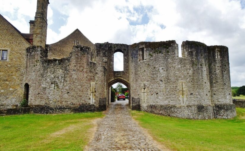
Leybourne Castle gatehouse was introduced to this blog last summer, just before the commencement of a programme of CST funded survey and research. The work is now complete, and really does show the value of in-depth studies like this: a somewhat different, and much more interesting picture has emerged. The Welsh Marches aspects of the gatehouse design had been noted, along with patterns of baronial influence including the close links between Leybourne’s lords and the Valence earls of Pembroke; a start-date between c.1300 and 1310 had also been mooted. However, certain key features revealed by detailed study of the gatehouse allow its dating and affinities to be refined more closely, while pointing fairly persuasively to a female builder.
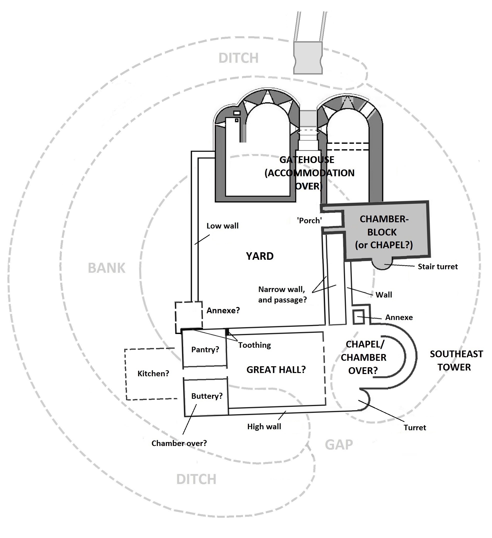
Figure 1: Plan of Leybourne Castle copyright Neil Ludlow
With origins as a ringwork castle, Leybourne was later ‘fortified’ in masonry, rather lightly, to become a rectangular courtyard house somewhat awkwardly superimposed upon the earlier earthwork. The masonry comprises a twin-towered gatehouse attached to a large, rectangular storeyed building – now gone – that may have been a chapel or, perhaps more likely, a chamber-block. The latter appears to have been connected by a passage to a third D-shaped tower at the southeast corner. This tower lies opposite a smaller, rectangular building at the southwest corner, that may represent a service-block and overlying chamber, with a Great Hall formerly lying east-west between them. The remaining side of the castle, to the west, was defined by a lowish wall.
Figure 2: Leybourne Castle Gatehouse north elevation copyright Neil LudlowFigure 3: Leybourne Castle Gatehouse south elevation copyright Neil Ludlow
Stylistic evidence suggests all the masonry at the castle belongs to one overall campaign, centering on the years 1305-25 and showing influence from the Welsh borderlands – probably via associations between the Leybourne lords and two Marcher families, the Valences and the Cliffords. The evidence for its dating and affinities is fairly precise, and can be summarised as follows –
The gatehouse shows a high outer arch, a feature with origins in the Welsh Marches 1280-1300.
It also shows fully-oilletted cruciform loops, which were similarly developed in the Welsh Marches 1280-1300 where they were extensively employed by the Clare lords of Glamorgan, and also by the Valences. One of the Leybourne loops survives unaltered, demonstrating that they are original features, though mostly now rebuilt or modified.
The gate-passage lies beneath a quadripartite rib-vault, normally confined to the 1330s onwards but with an early example in the gatehouse built by Aymer de Valence, earl of Pembroke, at Bampton Castle, Oxon., in 1315-24.
A ‘letterbox chute’ overlies the entry, as at Caerphilly Castle, Glam. (1270s) and Bampton Castle (1315-24).
The entry is deeply recessed between flanking towers, as in Edward I’s Welsh Castles at Rhuddlan, Harlech and Beaumaris (1270s-1300).
The windows have double-chamfered rebated surrounds, in a Marches style and similar to windows built by the Valences (1280s-90s) and another Marcher lord, Robert de Clifford (1300-1314), eg. at Goodrich Castle (Herefs.) and Brough Castle (Westmorland).
The Southeast Tower shows a doorway with a raised threshold (like a ship’s bulkhead door), as in work from 1300-1310 at Bothwell Castle, Lanarks., and Brougham Castle, Westmorland, by Aymer de Valence and Robert de Clifford respectively. Two more possible raised thresholds have been revealed at Leybourne in service trenches.
The portcullis would have been fully-visible when raised, as at Chirk Castle, Denbighs., and Tonbridge Castle in Kent, which itself shows considerable Marches influence; both are probably from the 1290s.
The portcullis grooves have ¾ round profiles as in the outer gate at at Corfe Castle (1280s), but their margins are refined with rounded chamfers.
The gatehouse is flanked by a D-shaped latrine turret that may be influenced by a similar turret at the Clares’ Llangibby Castle, Mon. (1307-14), at least in function, if not in its precise form: unlike Llangibby, it lies parallel with the axis of the tower.
It houses a fireplace with a rounded back, normally characteristic of earlier work but also seen in the Great Hall fireplaces at Pembroke Castle (William de Valence, 1270s) and Haverfordwest Castle, Pembs. (probably Aymer de Valence, 1308-15).
Aspects of their design, detail and planning suggest the D-shaped Southeast Tower, the former ?chamber-block and the Southwest Building were all contemporary with the gatehouse.
During the period 1305-25, Leybourne Castle appears to have been in the sole possession of a woman – Alice de Leybourne (née de Toeni). She received the castle and manor on the death of her husband Thomas de Leybourne in 1307, and all evidence suggests that she held it, in her own right, until her own death in 1324. She was the only beneficiary when her brother Robert died in 1310, providing the necessary resources. Under her tenure, Leybourne appears to have retained its status as the caput of an extensive Kentish lordship, and it is likely that the gatehouse represented accommodation, and administrative space, for its officials. Alice may therefore join the list, currently very short, of women castle-builders.
A number of other results have emerged from the present study. I suggest that a significant amount of work was undertaken by the Leybourne family at Leeds Castle, Kent, before it was acquired by Edward I’s queen Eleanor in c.1278, that this work included the creation of the lakes for which the site is celebrated, and that they may have been the inspiration for the lakes at Caerphilly Castle. It is also possible that the extensive work from c.1300 at Brough Castle, Westmorland, was undertaken by another woman – Alice’s aunt, Idonea de Leybourne.
Your donations make our research grants possible. But the grants go beyond the initial research, into the continuing and lasting impact which carries beyond far beyond the excavation season or the granting year. Research from two Castle Studies Trust grants can be seen at the upcoming Leeds International Medieval Congress in July 2025.
Every year, over three thousand medievalists from around the globe meet at the University of Leeds to present research, share new knowledge, make connections with others, and grow and foster the global community of medievalists. This major international conference also provides CST grantees a further platform to inform scholars about their research into castles. In 2025, under the special theme of ‘Worlds of Education,’ the Castle Studies Trust is proud to highlight papers and projects which have received CST support, financially or otherwise:
Initial images of Canterbury keep from the Visualising Canterbury Castle project, copyright Christchurch Canterbury
Prof. Leonie Hicks of Canterbury Christ Church University will be presenting initial research from Canterbury Castle in a paper titled ‘Digital Interludes: Methods of Teaching Castles.’ This work looks at her department’s digital castle work of which the project ‘Visualising Canterbury Castle,’ which was awarded £9631 from CST in 2025 is part of. This dynamic, multi-discipline project intends to create a detailed digital plan of the keep to understand the site, largely now in ruin but scheduled to reopen in correlation with the 1000th anniversary of William the Conqueror’s birth.
Excavating Newhouse Castle, copyright Ryan Prescott
Dr Ryan Prescott (University of Leeds) will be presenting further research on Newhouse Castle, Lincolnshire, in a paper titled ‘Reframing Newhouse Castle: Lincolnshire and the “Anarchy.”’. In 2024, this project was awarded £9867 from the Castle Studies Trust. Dr Prescott and team are seeking to understand and determine the nature of the castle at Newhouse and the lower gentry’s places within the sphere of the Anglo-Norman Civil War (1138-1154.) As seen with this paper, the impact of this award is continuing beyond the excavation which the CST funded.
Your support and donations make these projects possible, including the lasting impact we see from them in the academic sphere as well as the wider world.
Further research and outreach fostered by the Castle Studies Trust will also be seen at Leeds. For example, two papers stem from initial presentations at our 2023 CST anniversary symposium.
One of our assessors, Dr Erik Matthews with the Hornby Castle Project, Northallerton, will be presenting continuing research on ‘The Religious Experiences of an Elite Household in Medieval Wensleydale, 1000-1550.’ Dr Matthews initially presented this research on ‘Hornby Castle, Wensleydale, North Yorkshire: An Elite Holiday Home of the Later Middle Ages’ at our 2023 anniversary symposium. Dr Matthews also acts as one of the CST’s expert assessors for grant applications. You can read more about his work at Hornby at our blog.
Similarly, Dr Lorna-Jane Richardson, University of East Anglia, will be speaking at Leeds about ‘Modern Myth and ‘Medieval’ Identity: The Case of Bungay Castle.’ Dr Richardson likewise first presented this research at our 2023 anniversary symposium. You can read more about her work from her blog post here.
Possible image of Eleanor of Castile at Overton Church, copyright Rachel Swallow
More of our Trustees and Assessors are also presenting work at Leeds: Dr Rachel Swallow of Swallowtail Archaeology will present her ongoing work on Queen Eleanor of Castile and the contexts of her castles with a paper ‘Leisure, Literature and Legend: Reconstructing Edward I and Queen Eleanor of Castile’s Castles and Boroughs through Innovative Landscape Contexts.’ You can read more about Dr Swallow’s ongoing research on the topic in her blog post with CST. Dr Swallow is one of our team of expert assessors for grant applications.
Dr Katherine Weikert, University of Winchester, will present new research into castles, pedagogy and the ideas-informed society with co-researcher Ruth Luzmore (University of Southampton) in their paper, ‘Timeless Terrains: Medieval and Modern Mental Landscapes Today.’ Dr Weikert has been a Trustee of the Castle Studies Trust since 2020.
From grantees to trustees, the Castle Studies Trust is at the forefront of new, exciting research into castles. Your support makes this all possible, and donations, however small, are put to good use. Thank you for your support.
Simon Coxall, Dig Director of our Clavering Castle excavation looks at the end of the excavation and what happens next.
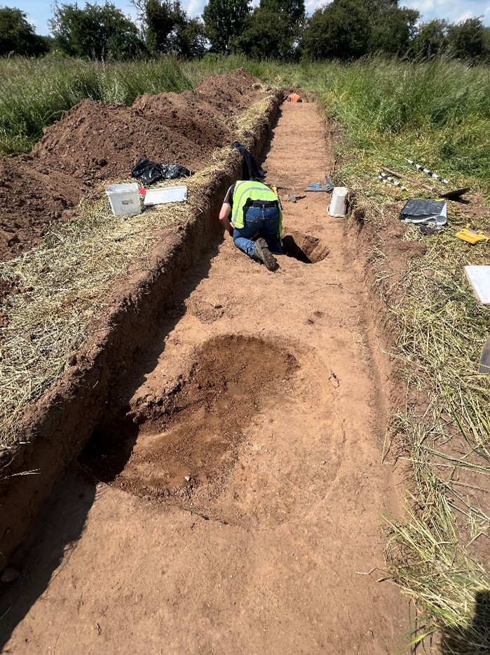
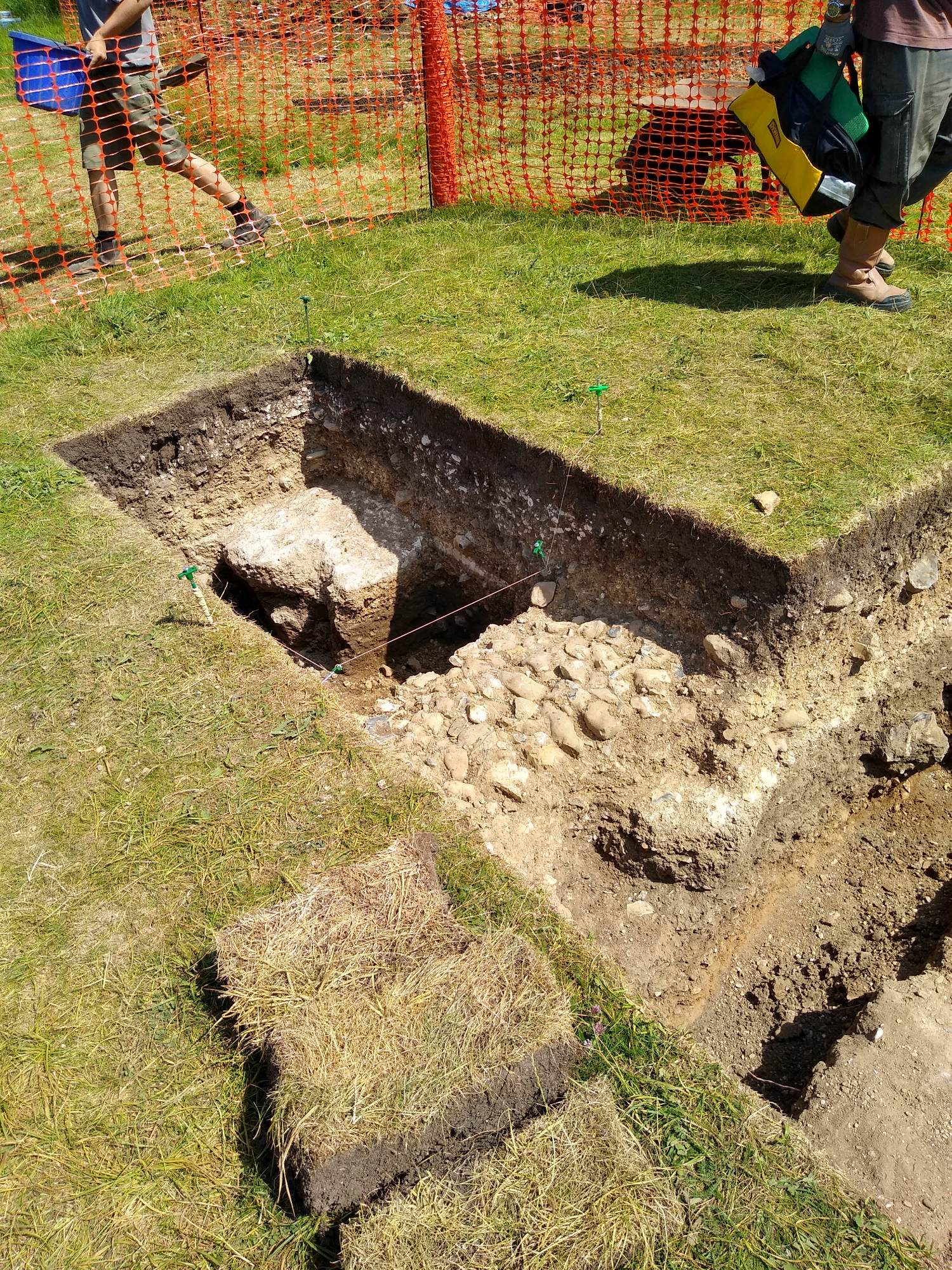
The excavation phase at Clavering castle neared completion in time for a community open day on Saturday 21st June 2025.
As well as welcoming around two hundred members of the public on a guided tour of the excavation trenches, the project has been blessed with visits from Historic England and Professor Robert Liddiard of the University of East Anglia.
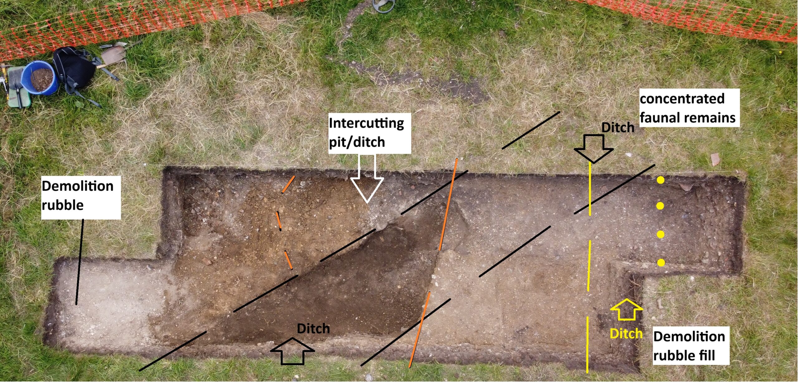
Trenches 1 and 2 at Clavering Castle from the Air copyright Simon Coxall
Trench 1 and 2 have now been thoroughly excavated, with just a little more to do in Trench 2 of which more below. Across much of the trench the layers representing the top of the original castle platform have been reached. The castle platform approximately 100m W- E by 60m N-S and approximately 4m deep was constructed by placing a large ‘brick’ of made-up ground in the valley of the River Stort and using the course of the river as the northern arm of the moat. The remaining three arms of the moat were then cut, their contents in part being used to build up the platform. Accordingly, there is no natural on site within reach of the excavation trenches, which have a maximum depth of c 1.25m. Nevertheless the uppermost surface of the platform at the time of its original construction is identifiable across both trenches. This layer is uniform orange-brown compacted clay with flint rubble in appearance and bears no evidence for occupation.
Chalk floor of possible gatehouse porter’s lodge in trench one, copyright Jeremy Cunnington
In Trench 1 cleaning and recording casts into sharper focus the features of the gatehouse entrance to the castle estate first exposed by geophysics in 2020. This consisted of a metalled trackway approximately 4-5m in width on a broadly N-S trajectory and bordered to its east by a flint walled building (??porters lodge) with chalk rendered internal walls and surviving chalk floor. At the time of the demolition, c1540’s, the tiles of its roof cascaded onto the adjacent trackway. The external faces of this structure directly abutted the trackway but had been completely removed down to their sandy gravel base by the demolition crew. On the western side of the trackway a further structure had been even more comprehensively demolished, the evidence being limited to a scattering of flint nodules just below the topsoil and a large pit full of substantial daub with their rod impressions still intact. There appears no later disturbance of the site suggesting, following its concerted demolition, neglect sealed the site as a capsule of life on site between c1050 and 1550.
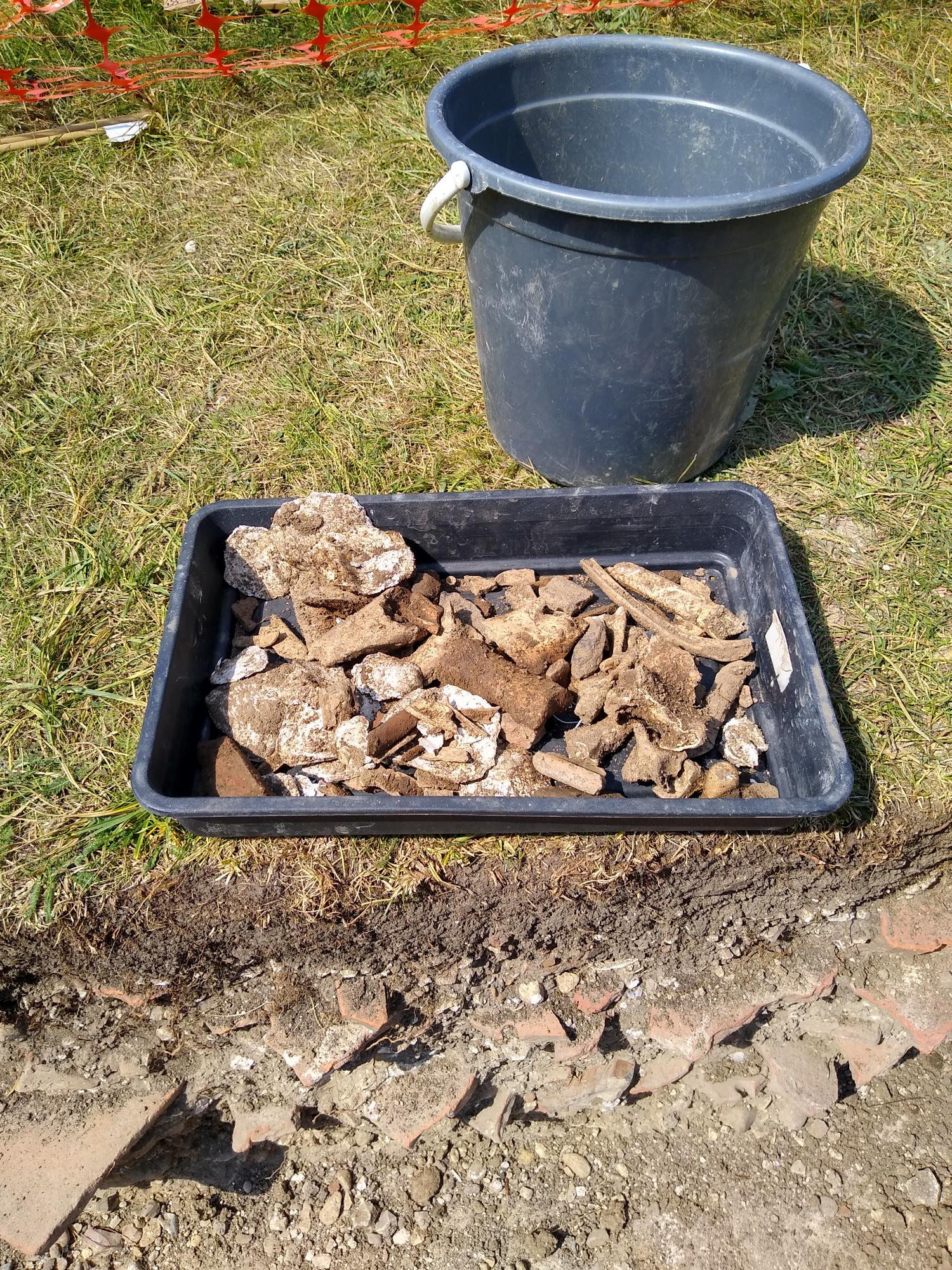
Some of the finds from 18 June from trackway of trench 1 from the earliest context excavated, copyright Jeremy Cunnington
The trackway has presented the potential for exploring a time slice of activity in this routeway area spanning the lifetime of occupation on the castle. As one descends here below the Tudor trackway, pottery recovered here stretches back from the glazed Tudor period wares through the earlier sandy wares to the shell-tempered wares dating back to the origins of the castle estate which is estimated as the mid-11th century. Small finds have also appeared: a 2cm gilded fastening or item of jewellery at some of the lowest levels in the sequence, together with a fragment of robust blue ‘vessel’ glass.
All is accompanied by hundreds of oysters within the demolition levels and hundreds of animal bones distributed through almost all contexts. Post-excavation analysis promises to define dating with greater precision.
Trench 2 from earlier in the dig, copyright Simon Coxall
Trench 2, while beyond the main evidence for structures, still betrays evidence for a concerted refashioning of the site roughly dated to the later 14th century. This coincides with historical evidence for the Neville family’s refashioning of the estate. An earlier surface cut into by ditches and pits associated with early phases of occupation, was across Trench 2 capped by a consistent capping layer of compacted sands and gravels, thus sealing the animal bone-rich contexts in such features. Approximately 1500 animal bones have been recovered across all contexts. It is intended this assemblage will be sent to a university as subject matter for a student’s zooarchaeological analysis.
The last of these ditches at the northern limits of the trench continues to descend deep into a ditch penetrating the sites’ original platform material. This continues to produce pottery including a large fragment of medieval mortarium and more animal bone some, of which will find themselves submitted for C14 analysis. These sealed dark humic contexts also lend themselves as key areas of environmental sampling which is being done by Oxford Archaeology East.
As with all sites, as trenches begin to be filled in, the work has only just begun.