Baffling Bolingbroke: understanding Henry IV’s home

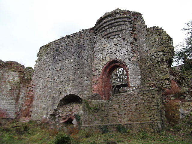
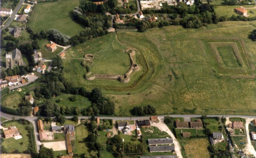
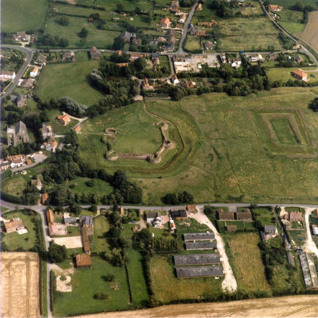
In rural Lincolnshire, nearly 30 miles east of Lincoln, stand the remains of a castle once held by royalty. The remaining walls and towers of Bolingbroke Castle are still 3m tall in some parts, and you can make out its distinctive hexagonal shape. The buildings that once crowded together inside the castle have long-since disappeared.

Bolingbroke Castle was founded in the 1220s by Ranulf de Blundeville, Earl of Chester and Lincoln and through marriage it ended up in the ownership of the House of Lancaster. John of Gaunt, Duke of Lancaster, lived here in the 1360s and the castle gave its name to his son Henry Bolingbroke, later crowned King Henry IV, who was born here in 1367. The history of the site is reasonably well documented, especially compared to castles not owned by the Crown, but there remain unanswered questions about its origins and development.

In 2018 we gave Heritage Lincolnshire a grant to delve deeper. They would carry out a geophysical survey to establish if there are buried remains immediately south of the castle and on Dewy Hill, which might be the site of an earlier castle, built before the stone one still visible at Bolingbroke.

Aerial photo of a green field surrounded by houses. At one end of the field stand the remains of a hexagonal castle.
Bolingbroke Castle on the left and the rectangular ‘Rout Yard’ on the right. Courtesy of Heritage Lincolnshire.

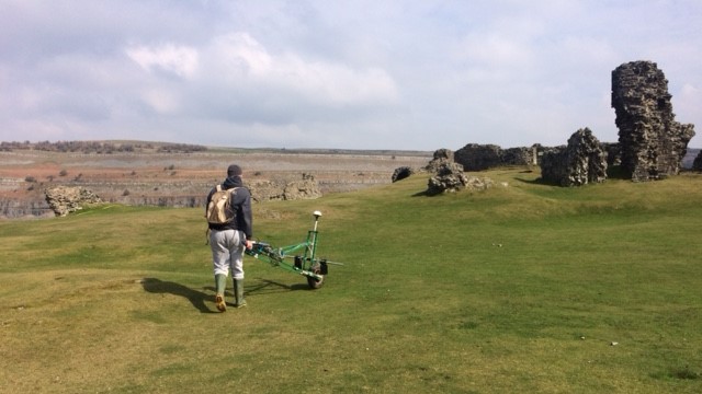
The plan was to use ‘magnetometry’. It works by measuring how magnetic the soil is and then plotting the results on a map. It allows you cover a large area quickly, and over the course of two days the Heritage Lincolnshire team surveyed more than five hectares (about five times the size of Trafalgar Square).

There is some natural variation in the soil, but typically human activity such as cooking hearths or stone walls have a different magnetic signature to the soil around them as they are made from different materials. Magnetometry can also be used to find filled-in ditches as the fill might contain traces of human occupation.

The first stage was to survey Dewy Hill, sitting 400m north-west of Bolingbroke Castle. It was excavated in the 1960s, and a digital survey of the terrain suggests a rectangular feature still survives. We hoped the geophysical survey would show how extensive the buried remains are, and the shape and size might give us an idea of what it is. Essentially, was it a castle or some other type of important place? There was a slight hitch…

But Heritage Lincolnshire did eventually get to take their magnetic gradiometer for a spin! Next, they surveyed the area south of the castle as it might contain an extension of the castle which has since been dismantled. Are there traces of this possible enclosure, or was there perhaps a garden here? In the later Middle Ages it was especially popular to shape the landscape around a castle. Right in the middle of this area is a rectangular piece of ground called the ‘Rout Yard’, but it’s unclear when it was created so the survey aimed to establish how this area relates to the castle.

Understanding the results takes a trained eye, and Heritage Lincolnshire have a highly skilled team of experts. They were able to find a few anomalies, but they either appear to be modern (there may be a concrete slab on Dewy Hill) or natural geological features.

The point of an exploratory project is to find out what lies beneath. Oddly, we expected something to be at Dewy Hill since earlier excavations suggested there might be some activity. The search for a possible bailey suggests that perhaps one did not exist or if it did it may have been insubstantial. That would mean the ruins we see today may represent the extent of the castle at its peak. Interestingly the fashion for having gardens might have passed Bolingbroke by. It was an important place, so may have begun to fall out of use by the time gardens became a common part of high-status medieval landscapes.

Despite the siege of 1643, the survey did not uncover ‘siegeworks’ which would have been built by the Parliamentarians. This might be because the siege was relatively short.

As a result of this work, we know more about how the surroundings of Bolingbroke Castle. Other types of geophysical survey may pick up different pieces of evidence, helping build a fuller picture of the area. Surveys like this are an important tool to understand sites, and Heritage Lincolnshire’s work will inform any future work at the castle.

Thank you to the owners, the Duchy of Lancaster, for allowing us to carry out the survey, to English Heritage who are guardians of the site, and to the volunteers from the local community who helped with the fieldwork. Projects like this really do take a village.

A full report has been prepared by Heritage Lincolnshire.

The six projects we’re funding this year

From 15 high quality applications we had to choose which ones we could fund. It certainly wasn’t an easy decision, but we have managed to support six different projects – the most we’ve supported in a single year – with a total of £22,000. You can learn more below, and if you would like to hear about the results when they are ready be sure to sign up to our newsletter.

Old Bolingbroke, Lincolnshire, England

Photo by David Hitchborne, licensed CC BY-SA 2.0.

Bolingbroke Castle was built by the Earl of Chester in the 1220s and Henry IV was born here in 1367. It is unclear how the Rout Yard and Dewy Hill were used, so Heritage Lincolnshire will carry out geophysical surveys at the castle to find out more about the site.

Pembroke, Pembrokeshire, Wales

Photo by ‘Jez‘, licensed CC BY-SA-NC-ND 2.0.

Founded in 1093, Pembroke is the oldest castle out of this year’s projects. Rebuilt by William Marshall, one of the most famous knight of his age, the castle was also the birthplace of Henry VII. Neil Ludlow and James Meek’s project will excavate in the outer ward to find out more about a late medieval hall. We also funded a geophysical survey at the castle in 2016.

Dig It!, castles of southern Scotland

With funding from the Castle Studies Trust Dig It! will be producing a series of eight videos exploring castles in southern Scotland, and sharing them with an online audience. By making it easier to access information about these important historic sites through YouTube and Wikipedia the project aims to inspire the next generation of castle enthusiasts!

Keith Marischal, East Lothian, Scotland


The Castle of Keith belonged to the powerful Keith family. The castle has since been demolished, with some parts built into Keith Marischal House which now stands on the site. Miles Kerr-Peterson and and Rose Geophysical Consultants will be carrying out a geophysical survey to search for the castle’s lost tower and great hall.

Laughton-en-le-Morthen, South Yorkshire, England


The castle is undocumented in medieval sources, but the earthworks of the motte-and-bailey castle are impressive: the motte itself is 9m tall. To find out more about Laughton-en-le-Morthen Castle, Duncan Wright will be carrying out a geophysical and aerial survey.

Ruthin, Denbighshire, Wales

Photo by Eirian Evans, licensed under a CC BY-SA 2.0 licence.

First documented in 1277, Ruthin Castle was controlled by Reginald de Grey in 1282. This once great castle is a ruin today and much in need of interpretation. To help with this, Chris Jones-Jenkins will create a digital reconstruction of Ruthin. Chris also worked on the reconstruction of Holt Castle, which was built around the same time some 18 miles to the east.

Stay in touch!

We will have updates from these projects throughout the year. Be sure to subscribe to our newsletter so you don’t miss out.

Subscribe to our mailing list

* indicates required


Another Bumper Crop of Applications for the Castle Studies Trust to Consider

The deadline for grant applications passed on 15th December. We’re going through the various projects now. Altogether the 15 projects, coming from all parts of Britain, are asking for over £63,000. They cover not only a wide period of history but also a wide range of topics. For a little more detail, here are the applications we’ve received:

  • Caldicot, Wales – a geophysical survey of the scheduled area of Caldicot Castle using magnetometry, resistivity, and Ground Penetrating Radar (GPR)
  • Dig It! 2017 Castles of South Scotland – enhancing public understanding and knowledge of some castles in southern Scotland, their purpose, their history and their relevance, particularly the lesser-known and least visited sites.
  • Dunyvaig, Scotland – co-funding a project to provide better understanding of the landscape context of the castle by conducting detailed topographic and geophysical surveys and carrying out trial trenching to gain key information regarding the preservation and the depth of the buried deposits.
  • Keith Marischal, Scotland – geophysical survey at Keith Marischal House, in search of a lost medieval castle and renaissance palace with a great hall reputed to be second in size to that of Stirling’s.
  • Lathom, England – excavations to find out the true size of Lathom Castle. You may recognised them from 2017’s grants when we funded analysis of masonry recovered from excavations between 1997 and 2009.
  • Laughton-en-le-Mortain, England  comprehensive archaeological investigation of the motte and bailey castle of Laughton-en-le-Morthen, South Yorkshire and its surrounding landscape.
  • Loch Kinord, Castle Island, Scotland – radiocarbon dating an early island castle: Castle Island, Loch Kinord, Aberdeenshire
  • Old Bolingbroke, England – revealing the history of Old Bolingbroke’s Castles: What can researching Bolingbroke Castle’s Route Yard and Dewy Hill tell us about Bolingbroke Castle?
  • Pembroke, Wales – test trenches at one of Wales’ greatest castles to confirm the site of the late medieval structure revealed in the geophysical survey funded by the CST in 2016.
  • Ruthin Denbighshire – co-funding reconstruction drawing of this great Welsh Edwardian fortress. Ruthin was the town where Owain Glyndwr’s rebellion against English rule started.
  • Sheffield, England – record and examine the architectural fragments stored on the site of the castle found in previous excavations.
  • Skipton, England – an archaeological/architectural survey will be produced of the gate structures and flanking round towers of the inner ward of Skipton Castle.
  • Snodhill, England – geophysical survey and excavations to answer some key remaining questions of this important Welsh border fortress re: the castle namely where was the entrance and function of the North Tower.

The applications have been sent to our expert assessors who will go over them. You can see how the assessment process works in one of our earlier blogs.