The Castle Studies Trust is delighted to announce the award of five grants, totalling a record amount of £42,000, to a wide range of projects with different types of research. The amount means that since our foundation we will have given over £300,000 to castle research projects – a landmark to celebrate.
Canterbury, Kent: To create an interactive digital model of the castle’s keep. The keep is one of the largest surviving from early Norman England dating to the late eleventh / early twelfth century. Now much ruined and inaccessible to visitors due to instability, the project will use the findings of previous archaeological research to create an interactive model. Work will start in March and be completed within ten months.
Clavering Castle platform copyright Simon Coxall
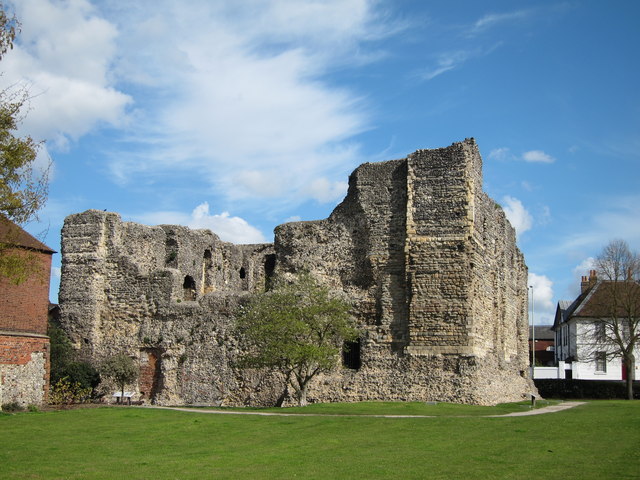
Clavering, Essex: To fund an excavation to help understand the development of the site which was occupied for over 600 years and which could be one of the very few pre-conquest castles in the UK. The excavation will build on the extensive survey work carried out by the local group of the site. They are planning to do the excavations in June.
Crookston Castle copyright Friends of Crookston
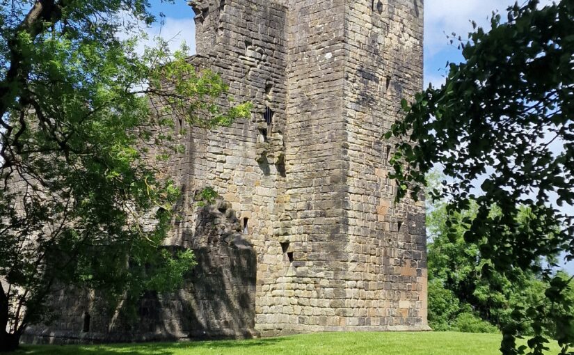
Crookston, Glasgow: A community-led geophysical survey, using multiple techniques, through which the Friends of Crookston Castle in conjunction with HES hope to learn more about Glasgow’s only castle. While the standing remains are believed to date from the early fifteenth century, it is believed that the castle dates back to the twelfth century. The group hopes to discover evidence of that earlier history and whether it was based on an earlier Iron Age hillfort. They plan to do the survey in early August.
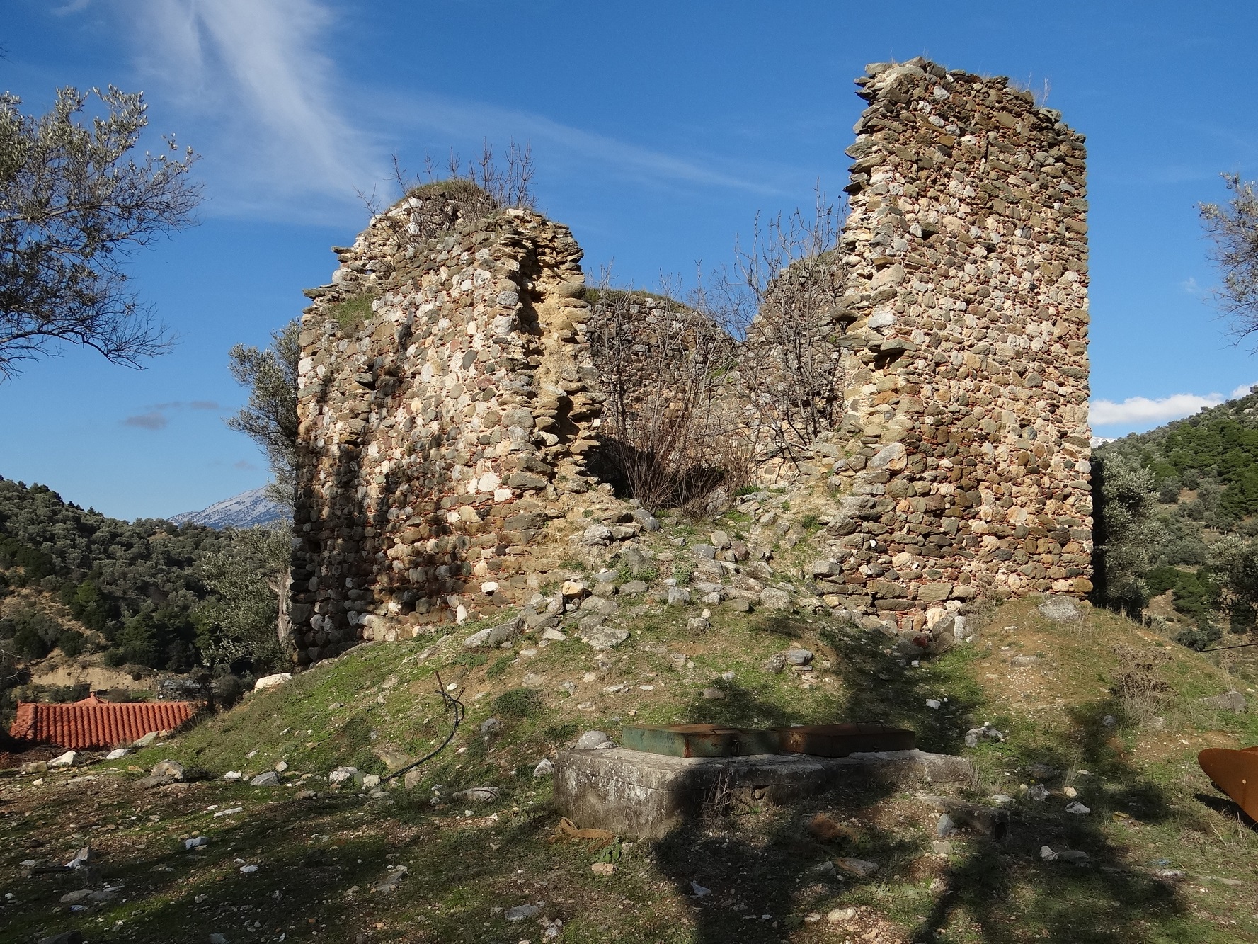
Knepp Castle copyright Richard Nevell
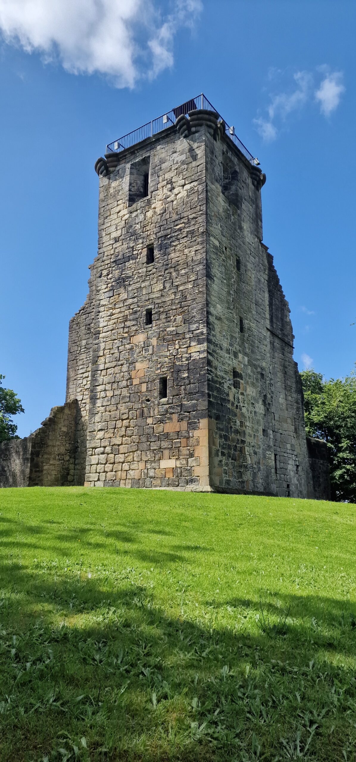
Knepp, West Sussex: An excavation building on a geophysical survey to better understand the site’s development and its relationship to the local area of this important baronial centre thought to be built by the de Braose family. The first documentary evidence is from 1210 when it was under royal control, documenting repairs, while the geophysical survey shows activity that pre-dates the extant stone tower. Excavations are planned for late July/ early August 2025.
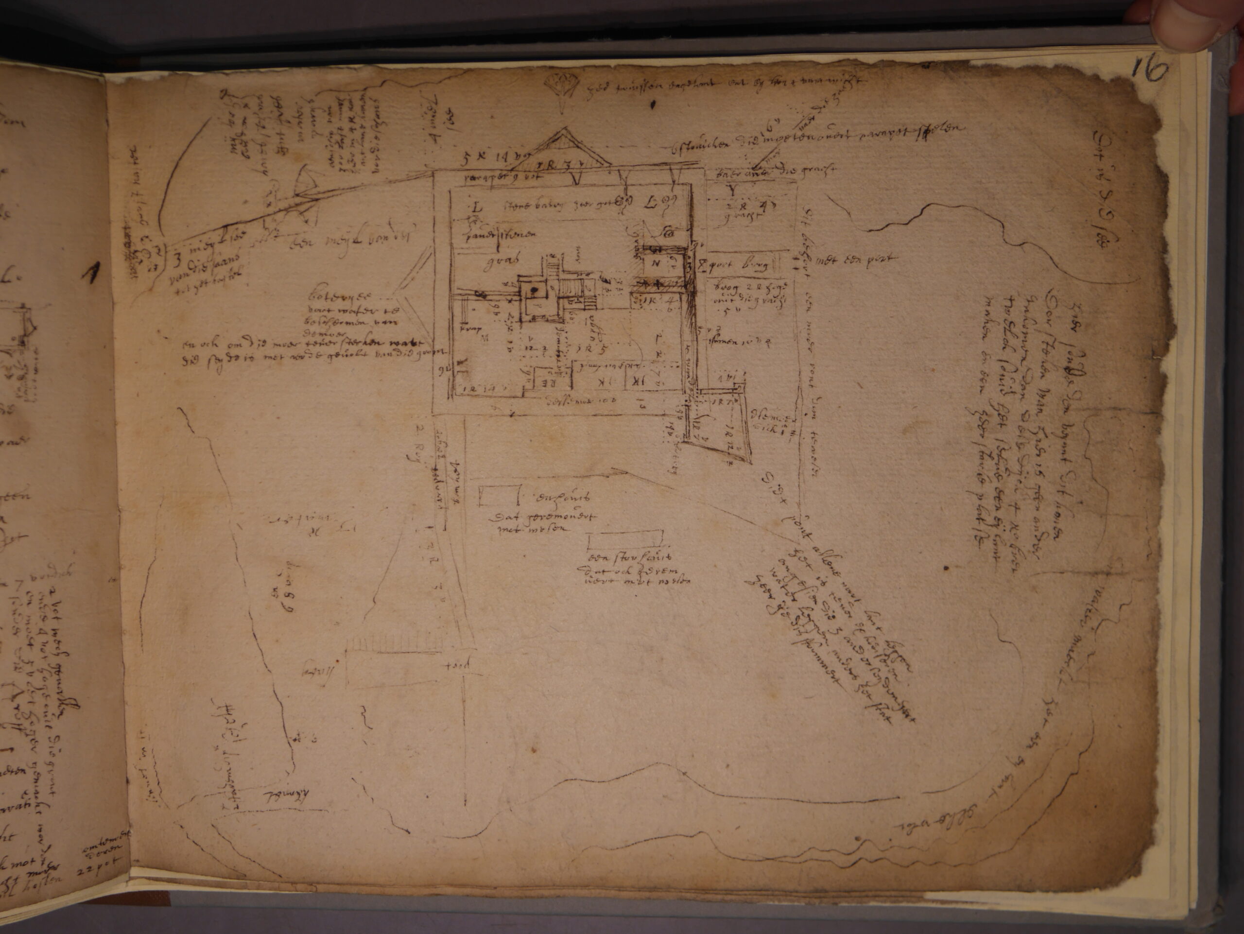
Image of Transcript copyright Esther van Raamsdonk
Transcription and translation of C17 Dutch Engineer’s Survey of English castles and fortifications: A joint project between Dutch academic Dr Esther van Raamsdonk and English Heritage to transcribe and translate part of an early seventeenth-century manuscript of a Dutch surveyor’s examination of castles and forts in England. The sample covers five of the 22 castles and fortifications in the document, which is called SP 9/99, held by the National Archives in Kew. The sample will include Dover, Walmer and Deal. The document is filled with detailed drawings and maps of these fortifications with often lengthy descriptions of their condition. Esther has already started work on it.
Dr Ryan Prescott, project lead, looks at what the excavations at Newhouse have uncovered, now the final report is in.
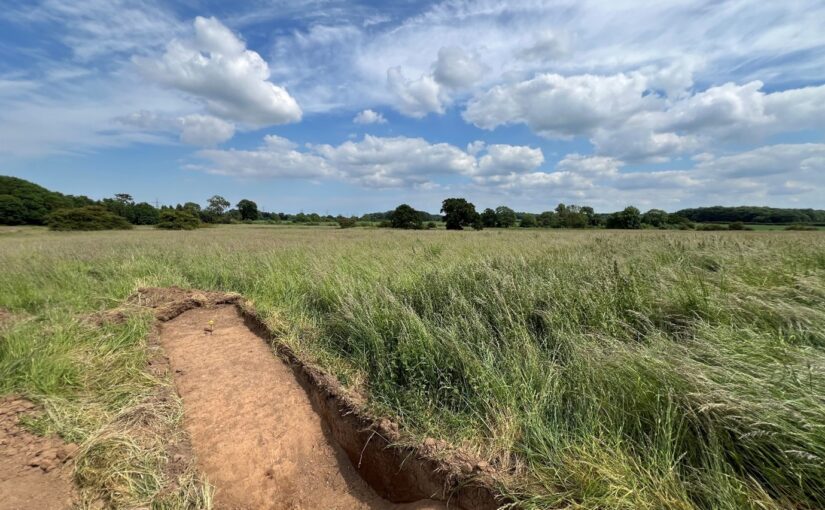
In June 2024, a team from Humber Field Archaeology completed a trial excavation at the presumed site of Newhouse Castle in Brocklesby, North Lincolnshire, generously funded by the Castle Studies Trust. The fieldwork, which followed a geophysical survey conducted in 2023, aimed to uncover evidence of the castle which was soon replaced by a monastery during the period known as ‘The Anarchy’. The results of the excavation, now available in the post-excavation report, have provided fascinating insights into the site’s more complex history.
Two trenches were carefully excavated, revealing a narrative that spans many more centuries than what had previously been understood about the site:
Prehistoric Activity: Flint tools and pottery fragments hinted at Neolithic and Bronze Age activity, suggesting the site has held importance for millennia.
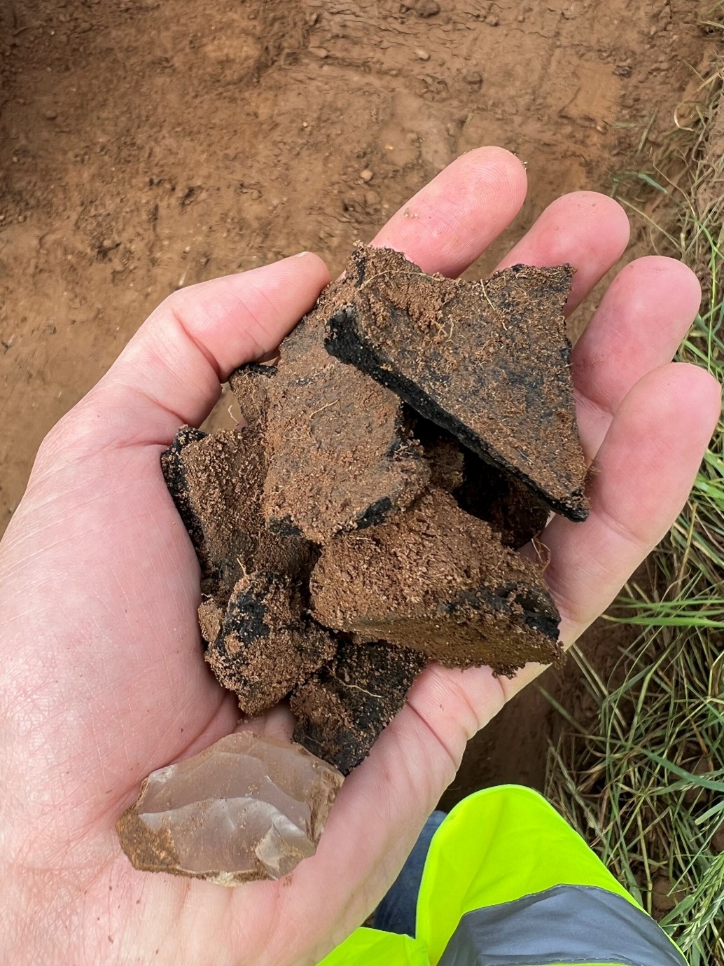
Anglo-Saxon Origins: A potted cremation burial, complete with grave goods like a knife and a decorated glass bead, was unearthed in Trench 1. This burial, dating back to the mid-6th century, suggests the site was already significant long before the construction of the castle and abbey at Newhouse. Nearby, leather and woven textile fragments were recovered, providing a rare glimpse into the craftsmanship of the era.
Medieval Ditches: Sections of a moat-like ditch encircling the earthwork were excavated. Their sharp cuts and rapid infilling suggest limited use. Although devoid of finds evidence (very frustrating!), a post hole was recovered near to the ditch within the interior of the earthwork, possibly tied to the short-lived history of Newhouse Castle.
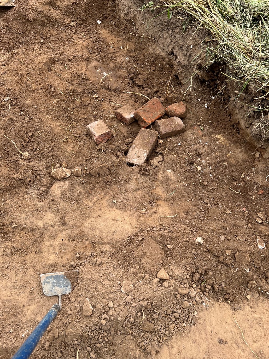
Post-Medieval Activity: Traces of later use included 17th-century brick deposits, potentially linked to landscaping efforts attributed to Capability Brown when it would appear that material was moved across the site in this new phase of occupancy.
Pottery fragments and flint tools show how the site was occupied long before the mid-twelfth century.Early Modern brick assemblages underline the continued use of the site following the Dissolution of the Monasteries.
Summary
The findings from Newhouse underline the site’s long-term occupation and its ongoing significance in the landscape of North Lincolnshire. Although no definitive structural remains of the castle were identified (this was always going to be tricky!), the excavation enhances our understanding of how the site evolved—from its prehistoric roots, to its medieval prominence, and beyond.
The full post-excavation report is now available, offering a detailed account of the discoveries and their importance. Perhaps inevitably, we have sparked potentially more questions than answers. However, we have nonetheless helped to advance the debate and our understanding of this intriguing site. We extend our gratitude to the Castle Studies Trust for their support.
The final report is on the project page of our website.
The deadline for grant applications passed on 29 November. We’re going through the various projects now. Altogether the 13 projects, coming from all over Britain, are asking for over £84,000. They cover not only a wide period of history but also a broad range of topics.
We will not be able to fund as many of these projects as we would like. To help us fund as many of these projects as possible please donate here:
In a little more detail here are the applications we’ve received:
Cainhoe, Bedfordshire: Through various forms of media such as reconstruction drawings, models and generative AI video and prints, the Greensand Trust aims to provide visitors and educational groups with a better understanding of what this motte and bailey castle looked like, the lived experience there and why it is significant.
Canterbury, Kent: To recreate an interactive digital model of the castle’s keep. The keep is one of the largest surviving from early Norman England dating to the late eleventh / early twelfth century. Now much ruined and not accessible to visitors due to instability the digital reconstruction will use the findings of previous archaeological research to create an interactive model.
Castle Sinclair Girnigoe, Caithness: The castle was the principal seat of the Sinclair Earls of Caithness and was built between the fourteenth and fifteenth centuries. The application is to help publish the results of the archaeological research carried out during the emergency stabilisation of the site between 2002-2011. The grant will be to fund both ceramic and clay pipe analysis as well as some illustrations.
Chester, Cheshire: To create reconstructions of the inner and outer wards of Chester Castle as it may have looked in its heyday to add to the one currently being prepared on the Agricola Tower. Chester was one of the major castles of the Welsh Marches and was the base for Edward I’s campaigns in Wales.
Clavering, Essex: To fund an excavation to help understand the development of the site which was occupied for over 600 years and which could be one of the few pre-conquest castles in the UK. The excavation will build on the extensive survey work carried out by the local group of the site.
Cockermouth, Cumbria: Dating from the mid twelfth century this large northern baronial fortress has seen many periods of development but its evolutionary history has never been subject to systematic or formal assessment. The project will focus upon developing a detailed understanding of the physical fabric of the castle’s superstructure.
Cooling, Kent: Co-funding the creation of a model of Cooling Castle gatehouse. The castle gatehouse is scheduled at Grade 1 by Historic England underlining its importance. The Gatehouse was constructed by Thomas Crump on behalf of Sir John de Cobham in the fourteenth century. The design is interesting in that the towers are horseshoe shaped with no apparent back to them and were one of the first places to incorporate gun loops.
Crookston, Glasgow: A community-led geophysical survey, using multiple techniques, through which the Friends of Crookston Castle in conjunction with HES hope to learn more about Glasgow’s only castle. While the standing remains are believed to date from the early fifteenth century, it is believed that the castle dates back to the twelfth century. The group hopes to discover evidence of that earlier history and whether it was based on an earlier Iron Age hill fort.
Dundonald, Ayrshire: To fund a building survey of what is thought to be primarily the late fourteenth century remains of this baronial castle and perhaps reveal any evidence of the early thirteenth century castle. In addition the grant will help fund community outreach to explain the results.
Ellesmere, Shropshire: Geophysical survey of the large motte and bailey castle in Shropshire which prior to June 2024 had never been surveyed before when the large motte was surveyed by GPR which revealed possible buildings. The resistivity and magnetometry surveys would confirm that, as well as survey the rest of the site which played an active part in the Marcher disputes in the reign of Henry III.
Knepp, West Sussex: An excavation building on a geophysical survey to better understand the site’s development and its relationship to the local area of this important baronial centre thought to be built by the de Braose family. The first documentary evidence is from 1210 when it was under royal control, documenting repairs, while the geophysical survey shows activity that pre-dates the extant stone tower.
Picton, Pembrokshire: To create a detailed reconstruction of the castle as it was first built in the early fourteenth century. This will be largely based on the detailed survey work the Trust funded in 2023.
Translation of C17 Dutch Engineer’s Survey of English castles and fortifications: A joint project between Dutch academic Dr Esther Raamsdonk and English Heritage to do a sample translation of five of the 22 castles and fortifications surveyed in a document called SP 9/99, an early seventeenth-century manuscript of a Dutch surveyor’s examination of the sites, held by the National Archives in Kew. The sample will include Dover, Walmer and Deal. The document is filled with detailed drawings and maps of these fortifications with often lengthy descriptions of their condition.
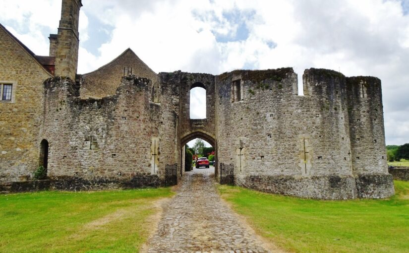
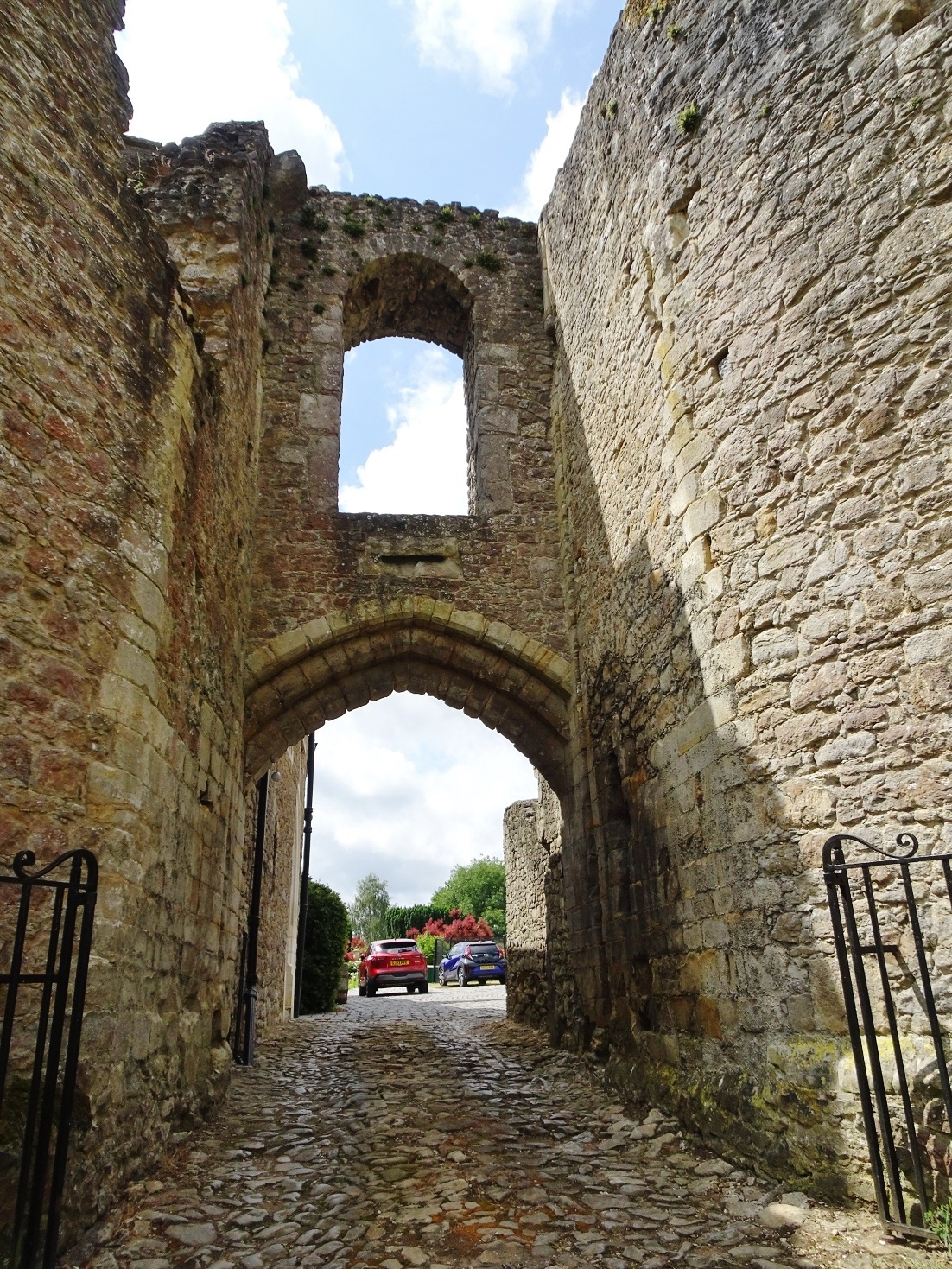
Starting on 8 October 2024, Philip Poucher of Heneb – Dyfed Archaeology (formerly Dyfed Archaeological Trust) will carry out a laser-scan survey of the gatehouse at Leybourne Castle, near Maidstone in Kent. The survey will be supported by a full programme of research by Neil Ludlow who outlines the importance of such a survey.
A small baronial castle, picturesquely sited on a low bluff above the village church, Leybourne has been occupied since it was built in the 11th or 12th century, and is still a private family home. It is not generally open to the public and no structured recording has so far taken place, while no accurate site drawings exist. The work, which is wholly-funded by the Castle Studies Trust, will fill this gap and greatly improve our understanding of this important site.
Fig. 1: Leybourne Castle – the gatehouse from the exterior. Present house to left, latrine turret to right. Copyright Neil Ludlow
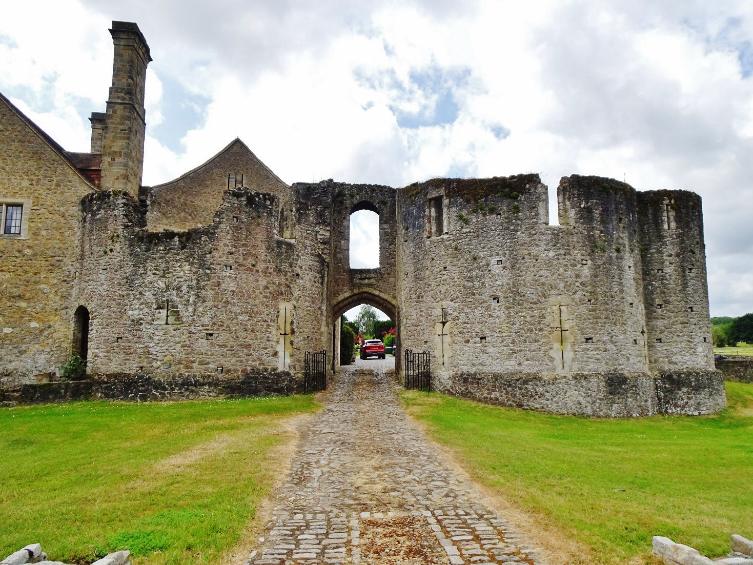
Beginning as a circular ringwork of around 0.12 hectares, Leybourne was later given stone defences, with a gatehouse that still dominates the castle. Centuries of alteration have masked much of the rest of the surviving stonework, but the present house – heavily restored during the 1930s in the Arts-and-Crafts manner – is built around the core of the medieval hall and chamber-block. A further building is thought to have been the chapel, while there are the remains of at least one other mural tower.
Fig. 2: Leybourne Castle – the gatehouse from the interior. Latrine turret to left, present house to right. Copyright Neil Ludlow
The date of these works is still uncertain. Our only record is from 1266, when King Henry III granted 4000 freestones to Leybourne’s lord, Roger de Leybourne. They are normally thought to have gone towards the defences, but these are entirely of rubble construction suggesting that the freestone may instead relate to an upgrade of the domestic buildings. So the key to understanding the development of the defences is the gatehouse, which despite alterations through time, and the loss of its rear half, is substantially as built. Nevertheless, its precise form has never been properly established – published accounts are based on drawings produced by Sidney Toy, in 1927, which are somewhat misleading in many important details.
The gatehouse is of unusual design. It has been regarded as transitional between the simple twin-towered gatehouses of the early/mid-13th century and the more complex structures of the late 13th century onwards, but appears to be somewhat later. It is two storeys high, with D-shaped towers flanking a narrow gate-passage that was formerly rib-vaulted. The entry lies beneath a high outer arch and is deeply set back between the towers, characteristics that were both introduced, in Wales, during the 1280s. And the entrance arch lies beneath a horizontal chute outlet, somewhat like a letterbox in outline. This is a feature of debatable function, but which was notably employed at Caerphilly Castle by Gilbert de Clare in the 1270s. In addition, the gatehouse towers are of unequal size and projection, as in the Clare’s gatehouse at Llangibby Castle (Monmouthshire), probably built c.1307-14, while both gatehouses show a D-shaped flanking latrine turret. Incorrectly shown by Sidney Toy, it lies parallel to the towers at Leybourne, unlike Llangibby where it projects at right-angles. And while the arrowloops at Leybourne were restored as fully-oilletted ‘Clare-style’ cross-loops in Toy’s drawings, alteration during the 18th and 19th centuries has in fact masked their original form and the evidence for any original oillets is questionable.
Fig. 3: Leybourne Castle gatehouse – the ‘letterbox’ chute.
So the gatehouse has a highly individual design, which is of international significance. While it may largely be down to personal choice by its patron and master-mason, at least some influence from the Clares is unquestionable. This may have emanated directly from the Clares’ nearby centre at Tonbridge, but Welsh aspects of the Leybourne design may point towards additional input via an intermediate lord such as William de Valence, who also used ‘Clare’ motifs and was very powerful both in Wales and in this part of Kent. At any rate, the combination of features suggests a date long after 1266 and probably in the early 14th century – perhaps under Roger de Leybourne’s son William, or his grandson Thomas, between c.1300 and 1310. However, on current evidence much of this is speculative: these are the key questions the project will seek to answer, in addition to producing survey data.
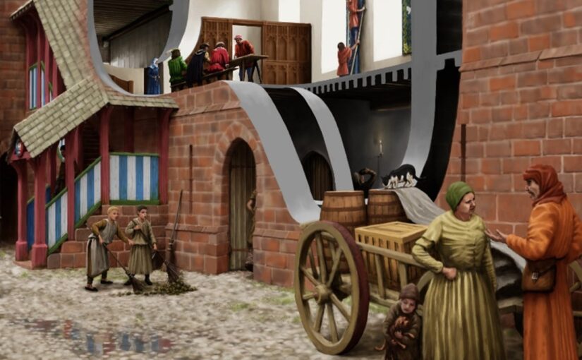
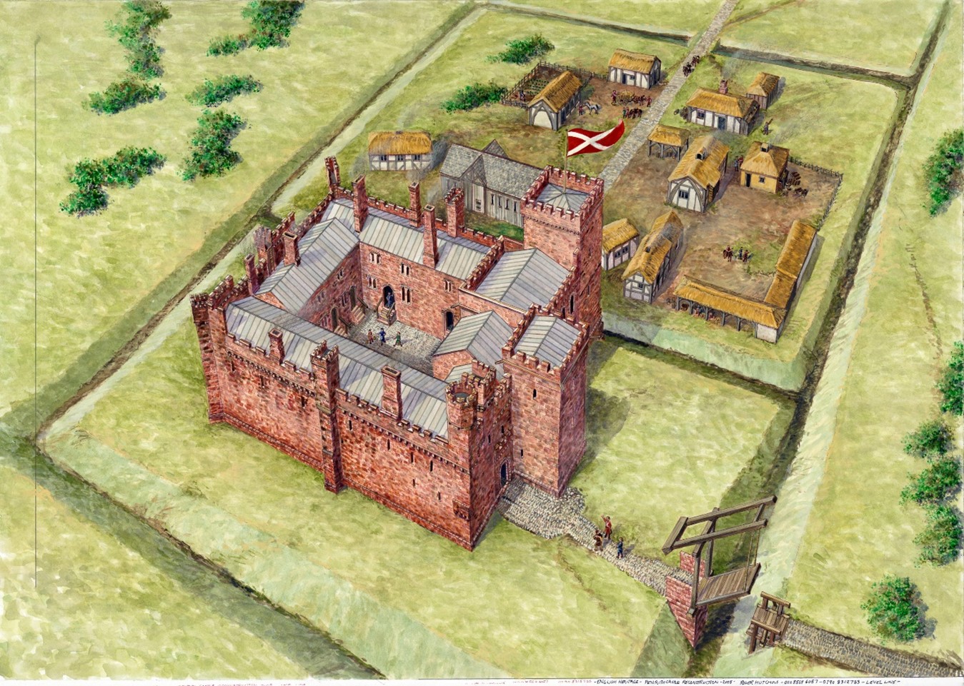
English Heritage is pleased to be a recipient of a generous grant from the Castle Studies Trust to create a new reconstruction image of Penrith Castle (Cumbria, England). Grant co-awardee Will Wyeth (Properties Historian, English Heritage) discusses this work in the context of the charity’s ambitions for public history.
The castle of Penrith, made of striking red stone, is arranged in four roughly equal ranges bounding a central off-square courtyard. Of the two towers there survives, the Red Tower retains its north-east wall and, and the White Tower a vaulted ground-floor chamber.
Scholarly consensus ascribes three major phases of construction in the castle: a primary phase of the very late 14th century and two 15th-century phases, the latter of which was the more extensive. It is this last phase, credited to Richard Duke of Gloucester, which is the focus of the reconstruction image.
The castle today is thoroughly urban, and sits within a public park popular with residents and visitors alike. There are several panels offering information about the castle, including an aerial reconstruction of the site in the mid-15th century.
The existing reconstruction remains an excellent image. The ranges and towers are carried to full height, the lost courtyard is rebuilt and populated with buildings, while tiny human figures are visible across the site. However, as with many aerial reconstruction images, it has limitations as a device for public history. The image does not aid site orientation for visitors unfamiliar with the ruins or Penrith proper; and life at a human scale is difficult to imagine.
The new reconstruction aimed to address these limitations as well as draw in a further source of guidance. The work of looking after and developing the public history of English Heritage’s properties is supported by a worthy army of volunteers. Penrith Castle is lucky to have one such volunteer, Joanna, who is a true steward of the site’s public history and has led several tours of the castle, gathering feedback on visitors’ responses to it, and the available interpretation. Through Joanna’s experience, we realised we needed a new image, and imagining, of the castle and its everyday inhabitants.
It was necessary to start the process of identifying spaces in the castle from scratch. Several 16th-century surveys mention buildings and spaces with attendant measurements, but the detail is misleading. The missing portions of the site fabric today prohibit confidently identifying spaces such as a hall, chamber, kitchen, accommodations, etc. Certain architectural features survive which can help, but a convincing and comprehensive reconstruction was not achievable.
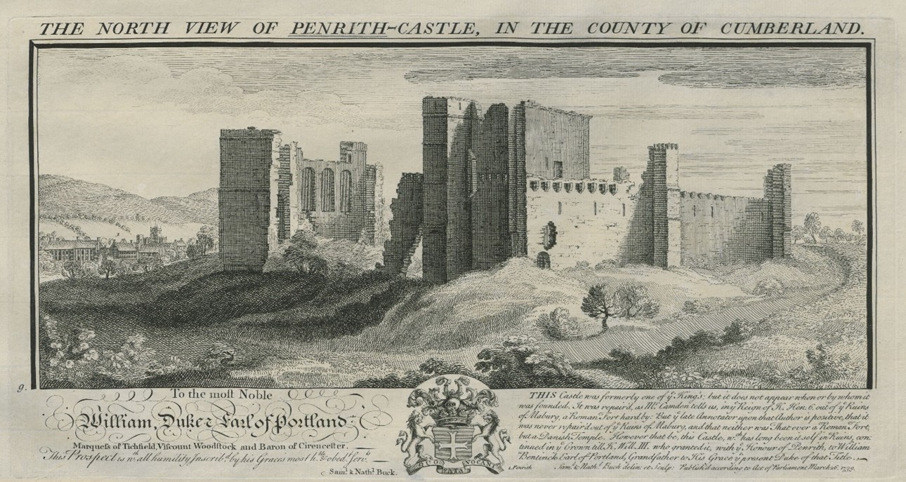
Figure 3. Buck brothers’ image of Penrith Castle, 1739. The segment of walling on the left with three tall round-headed windows probably depicts a better-surviving portion of the column of stone in Figure 1. In the centre of the image is the tall block (tower?) positioned on the western corner of the castle, now almost completely lost.
Some early images help to locate specific buildings. The Buck image of the castle (1739) illustrates the castle in a more complete state than today – including a complete section of walling where only the reveals and partial window-head of the ‘hall’ survives today – but it also testifies to the presence of a lost tall block positioned on the castle’s west corner (Figure 4).
The great hall was identified by the tall windows in Bucks’ image. This is an unorthodox position. It was unusual for a great hall to be positioned so close to the formal entrance to the castle (in the hall’s primary phase, positioned at the east end of the south range; in Gloucester’s time, just west of the hall). The kitchens which serviced it were also on the other side of the enclosure.
Other ideas were mooted. The presence of a chapel identified with some confidence at the upper level of the east corner of the castle precluded identification with this space in that capacity (see Figure 1). It is possible the three-windowed space was a private or state chamber. While feasible, this pushes the necessity of a great hall elsewhere in the castle where there is not space for it. The high wall outer wall of the surviving south-east range has few outer windows of any significance; the south-west range was, it would seem, dominated by the large tower depicted in the Bucks’ image and resting upon masonry identified with Gloucester’s work; while the north-west range in Gloucester’s time had a number of fireplaces at ground floor whose flues would rise through a first-floor hall set above them, making this alternative, hypothetical arrangement unlikely. For want of alternatives the present consensus, that that hall was in the positioned identified by the Bucks’ three-window wall, is probably correct.
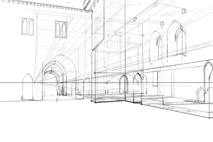
The new image was developed in collaboration with artist Pete Urmston from an existing photograph (Figure 4, left). This captured several parts of the site which we wanted to reconstruct – the great hall with access stairs, Red Tower and parts of the Gloucester-era gatehouse. It incorporates the part of the castle most familiar to passers-by – the Red Tower – and an assemblage of standing features which in general visitors find difficult to understand. This perspective also granted greater flexibility to create scenes of human interaction in the foreground of the image which might populate the castle and convey a sense of Penrith’s medieval community.
Figure 4. Base photograph used for reconstruction (top); first draft of reconstruction (bottom). Note the column of stone on the left image with window reveals is replicated (rebuilt) on the right.
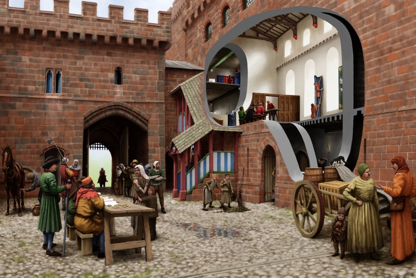
The process of reconstruction begins with a line sketch superimposed upon the base photograph (Figure 4), and hereafter a sequence of amendments and insertions ultimately leads to the final image (Figure 5). The cutaway into the great hall, and beyond into the Red Tower, gives some sense of the grandeur and scale of lost interiors. The clerestory in the hall, inferred from antiquarian sketches and some degree of analogy with that at Middleham Castle, is defined by windows set on a wall carried by a projecting corbel table. A two-door timber screen of late 15th-century design covers off the lower part of the hall. The window-heads of the gatehouse first-floor echo surviving dressed stone fragments found at Penrith.
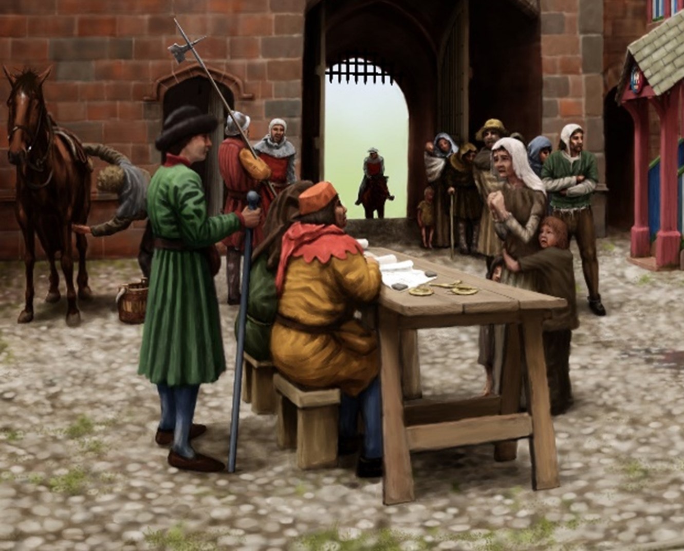
Perhaps most significantly, the castle is populated with a scene from its tenure by Richard of Gloucester – a meeting of castle staff with tenants and poor folk to hear pleas. A single figure who is attested at the castle and whose presence would be in keeping with a day-to-day scene in castle life in the late 15th-century is represented: Sir Christopher Moresby, depicted on the far left standing with a staff and wearing a green coat (Figure 6).
Moresby supervises under-stewards seated on stools and by a trestle table. Just in front of the restored stair block where a figure descends, painted in Gloucester’s colours of white and blue, are two boys sweeping the yard (Figure 7). Their attention has been captured by a black and white cat standing on top of some barrels. Behind them, through the cutaway, are two figures in the hall basement. One is just entering while the other is sampling (perhaps illicitly) the stores of ale.
In the hall at first floor are three parallel scenes: well-dressed figures are assembled on a long bench and trestle table in the hall proper. A woman enters the screened area at the low end of the hall from the buttery in the first floor of the Red Tower, visible through the inner cutaway. Leaning upon the sole standing piece of wall that survives in this space today, two servants are bringing down a blue hanging.
The new reconstruction aims to place the people of Penrith Castle at the centre of its re-imagination, while bringing back its lost buildings and interiors. In time the image will feature on a new panel scheme in the castle. In the immediate short-term, Joanna the volunteer is already armed with the image and sharing the new light it brings to the castle with visitors.
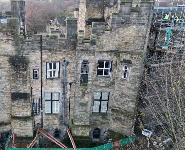
Post graduate student Tom Davies explains how he has taken some of the latest civil engineering techniques to help understand the condition of the stone work of old buildings, using Durham Castle as a case study.
Durham Castle was the building of interest for my master’s research project in 2023/4. Durham Castle has an incredible history, being founded in 1072 on the orders of William the Conqueror, to being the seat of the Prince Bishops, to now being part of a UNESCO World Heritage Site and University College for Durham University. The Castle’s rich history and architectural significance makes it preservation crucial, ensuring that its historic features are maintained for future generations.
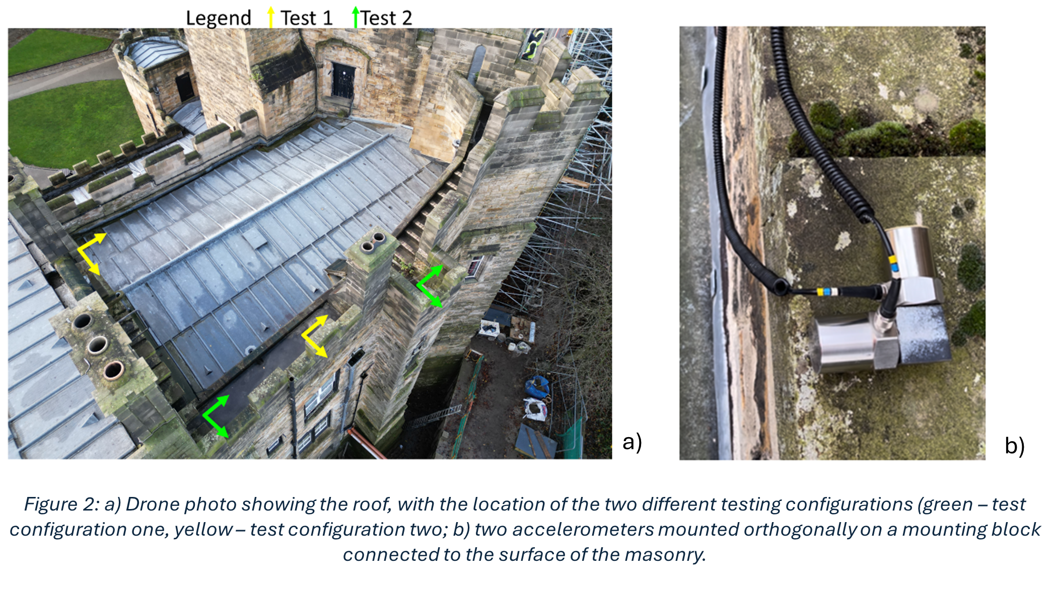
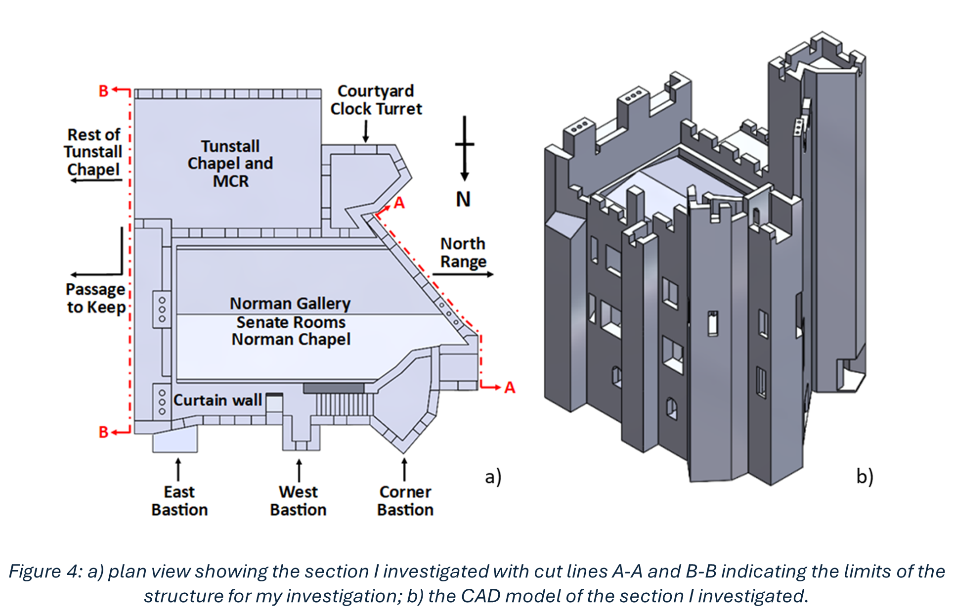
My research was based on understanding how a section centred around and above the Norman Chapel, the oldest building in County Durham, behaves under ambient excitation. Every structure experiences ambient excitation under normal operating conditions, it is the study of how a structure moves due to natural stimuli such as how it reacts to windy conditions and how it responds to when people move through the structure. Within the section I investigated, the Norman Chapel was on the ground floor, the Senate Rooms on the first floor, and some of the rooms of the Norman Gallery were on the second floor, with the roof above. These spaces, along with their remarkable examples of Norman architecture, make the conservation of this part of the Castle especially vital. The first non-destructive in situ testing I conducted was ambient vibration testing. This involves using multiple accelerometers in orthogonal directions (at right angles, seen in Figure 2) to record how the structure responds to ambient excitation, in this case measurements were undertaken on a windy day. Every building vibrates naturally at its natural frequency, which is determined by the building materials and structural connections of the building among other conditions. The taller the building, the lower the natural frequency, as they are more flexible. The Castle section I looked at is 3 storeys high, so one would expect a higher natural frequency than that of a structure such as the main tower of Durham Cathedral, which is 66m tall. The recorded accelerations were converted into frequency measurements which revealed information about the natural frequencies. This conversion is important, as when plots are made, it is possible to see different modes of vibration.
Copyright Tom Davies
In order to characterise the masonry parameters that were used in the numerical model and subsequent simulations, another type of non-destructive in situ test was performed, sonic tests. Some tests were undertaken within the Norman Chapel, as this is the oldest part of the Castle, and its masonry has therefore been subject to the most deterioration of any internal section of the Castle due to its age. Additional tests on a masonry panel in a Gallery (corridor) just outside the Norman Chapel were conducted, this is because this Gallery is a very similar age to the masonry of the rooms above the Norman Chapel, from around the 1600s. From this, the different ages, and therefore state of deterioration, of the masonry within the Castle could be included.
Copyright Tom Davies
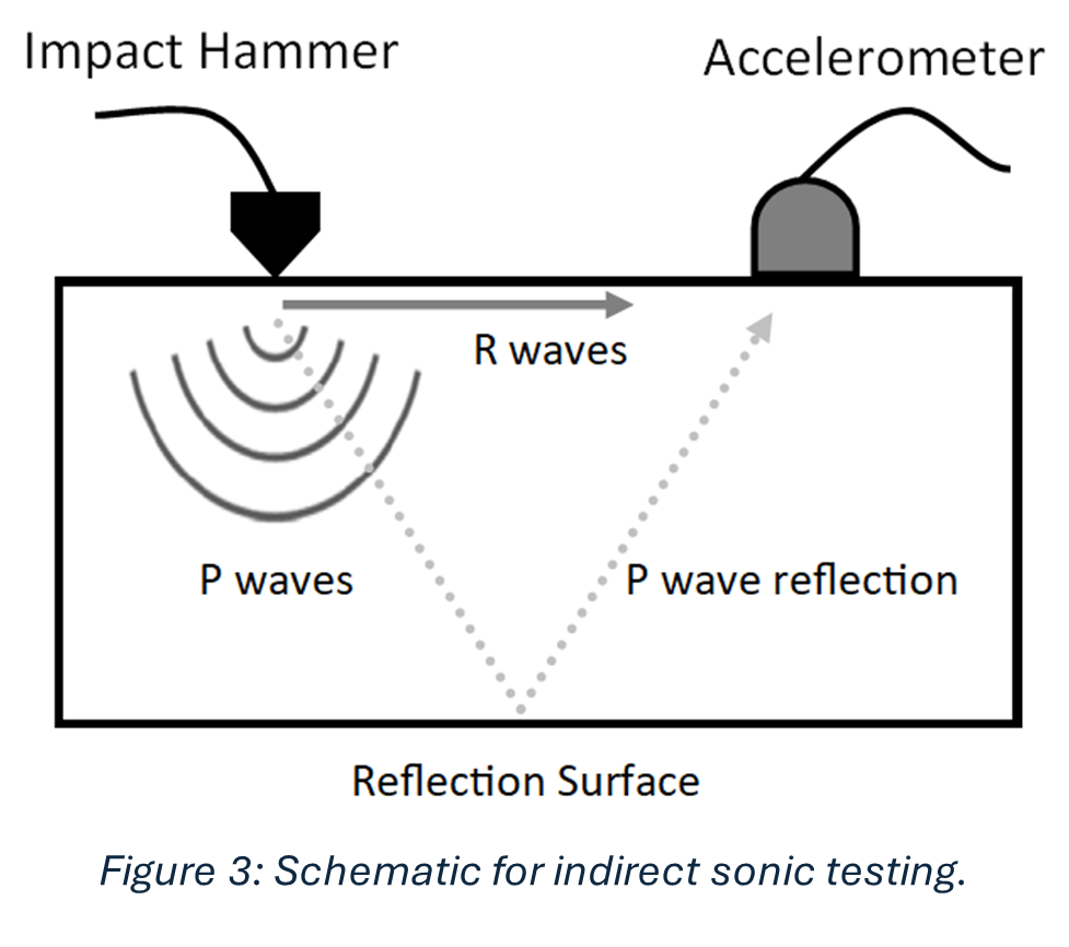
Sonic tests involve hitting the masonry, gently, with an instrumented hammer, shown in Figure 3, and recording the time it took for the subsequent waveform to be registered on an oscilloscope (a machine that shows waves) connected to an accelerometer. Figure 3 shows how this process works, there are two types of waves: P and R waves. The main difference is one travels along the surface of the stone, and the other travels into the stone and reflects off the back of it and returns to the surface. I will focus on the P waves (their names are quite confusing, but it is interesting to know that you can obtain the desired outcome, here the determination of material properties, using either wave). From the recorded wave you can work out the speed of the wave, and using equations you can work out material properties. This is an incredibly important in defining the characteristics of the material within the numerical model. I constructed a finite element model and applied appropriate boundary conditions to represent the foundations of the building, as well as the connections between the section I was investigating and the rest of the Castle. I used the results of the sonic tests mentioned above to determine the masonry material parameters. From the numerical simulations, global frequencies were determined and compared to the results of the ambient vibration testing. global frequency, I mean results that represent the structure as a whole, rather than only a little part of it such as the tower you can see in Figure 4b, or an individual wall. The goal of the finite element model was for its results to be as close to the results of the ambient vibration testing as possible, as this would indicate the model was good at replicating the actual behaviour of the building.
Copyright Tom Davies
Looking forward, there is a plan to undertake a multi-year project to investigate Durham Castle on a much larger scale, building on the work I have done with the target of investigating the entire Castle. The most intriguing prospect is that when a full finite element model of the entirety of the Castle is built, simulations of different loading conditions can be investigated. This would allow different situations to be modelled and the results determined before any physical changes were done to the Castle.
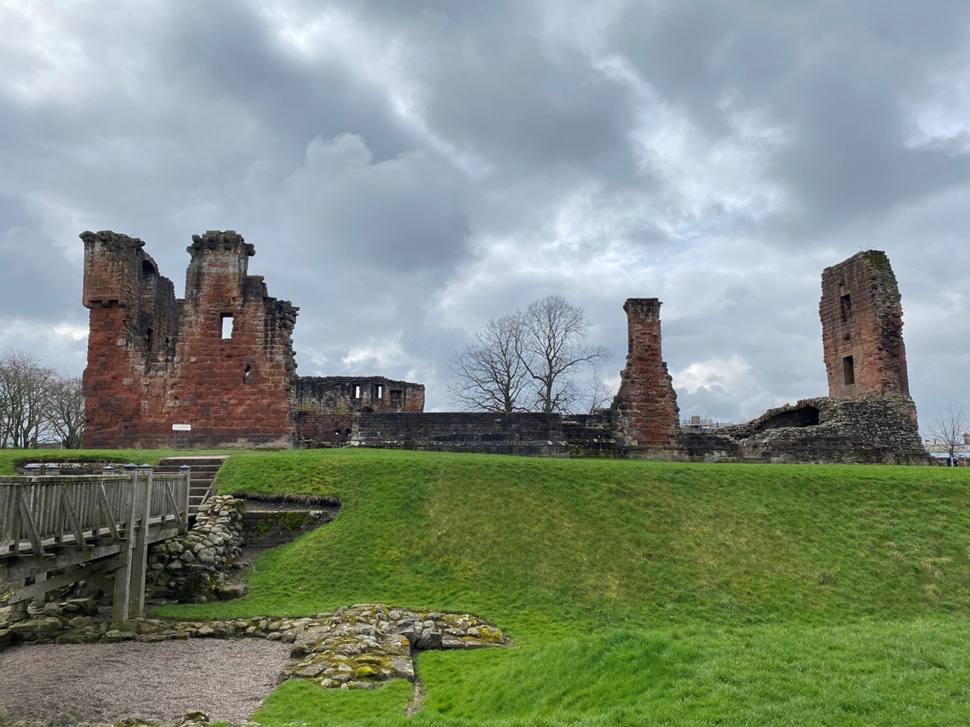
On Saturday, 24 August, the Higgins Museum in Bedford hosts an event to mark eight centuries since the town’s castle was subject to an 8-week long siege by the army of the teenage King Henry III (booking details at the end). Dr Peter Purton, FSA, outlines what happened in the siege.
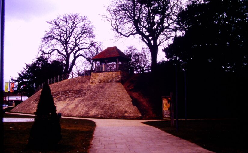
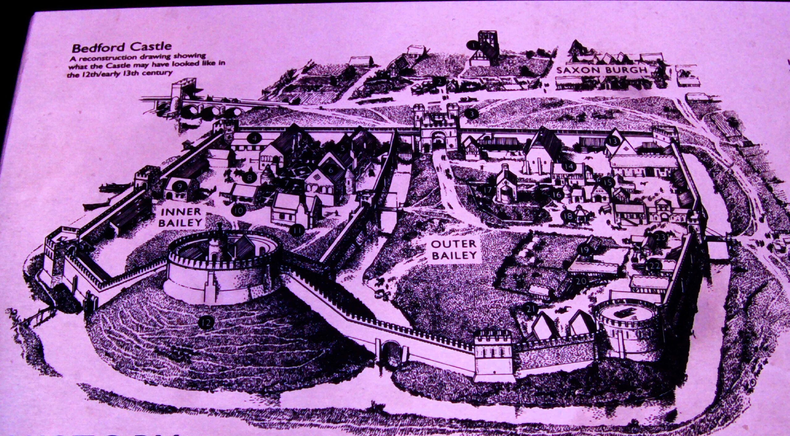
Not much remains now of Bedford Castle – just a degraded and much altered mound near the river Great Ouse in the town centre and a few excavated fragments of stone buildings, making it hard to visualise that it was once a large stone-built fortress with a moat, barbican, two wards and a stone tower on top of the motte which marked the original castle built after the Norman Conquest. A display board nearby reconstructs its possible appearance in 1224.
Image of display board showing how Bedford might have looked in 1224
In that year, Henry III was assembling an army which was to be transported to France in an attempt to recover Poitou, part of the once extensive Angevin empire. This plan unravelled with the rebellion of Fawkes de Breauté. Fawkes had been one of the captains of King John, Henry’s father, and had become rich and powerful. He had been granted Bedford castle and we are told that he had strengthened the fortifications to make it “impregnable”. Rebelling against the crown, he prudently left the country while leaving Bedford in the hands of his brother, who in arresting the justices sent there by the king made it inevitable that he would face royal retribution: this was a direct insult to royal authority and following years of civil war and rebellion following John’s reign, there was no possibility that it could be ignored. The royal army, assembling conveniently nearby at Northampton, was diverted to Bedford. What happened next was recorded in several contemporary chronicles while royal expenditure was detailed in surviving accounts, a combination of evidence which is rare enough and which allows an unusually detailed reconstruction of the siege.
The royal army deployed seven stone-throwing engines (mangonels and petraries) and built two siege towers but the garrison resisted stoutly and inflicted heavy casualties on the attackers. Eventually the barbican and outer ward were breached and captured by royal soldiers then miners, summoned from the Forest of Dean, brought down the wall of the inner bailey and did the same with the tower on the motte, to which the defenders had withdrawn. The prisoners were set free and the entire garrison was hanged as punishment for their rebellion. The castle was then demolished. A period of instability in England was thereby ended, but so too was English rule in Poitou, the French capturing La Rochelle at the same time as Bedford was being besieged.
These events were therefore of international as well as national significance, and through archaeology, it is possible to now know much more about Bedford castle. All these themes will be discussed at the conference on 24 August, the speakers are Professor David Carpenter, expert and author specialising in this period, Dr James Petre who has written about Bedford, Ben Murtagh who has been exploring Bedford Castle, Jeremy Oetgen (Albion Archaeology) who will update us on a long history of archaeology on the site, and the author of this blog who will place the siege in the context of contemporary siege warfare.
Anyone interested in attending can find all the details and book a ticket at the museum website: www.thehigginsbedford.org.uk. Tickets cost £15 and advance booking is encouraged.
Project lead, Steve Parry, looks at what he and the team from MoLA and the Higham Ferrers Archaeology and Research Society hope to achieve during their geophysical survey of the once royal castle of Higham Ferrers starting on Monday 15 July 2024.
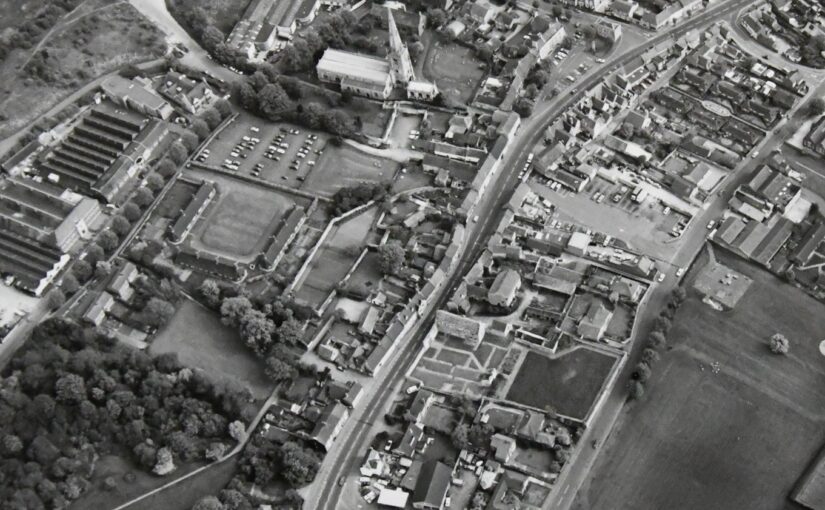
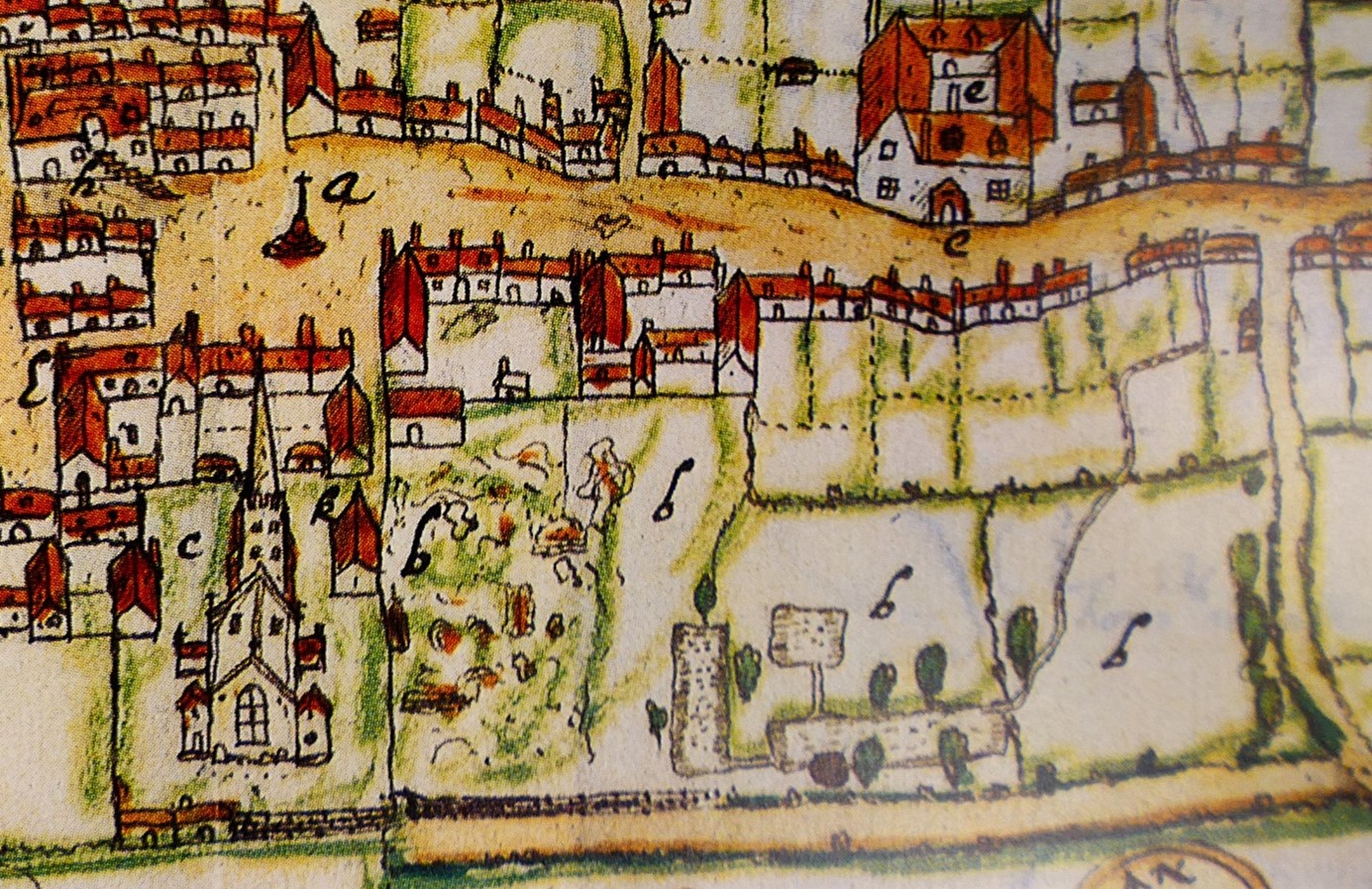
Walking through the streets of Higham Ferrers you’d be forgiven for thinking that you are looking at a pretty but provincial town. However, documentary records reveal that Higham Ferrers once played a role on the national stage. During the Middle Ages it had a substantial stone-built castle which served as the headquarters of the extensive Northamptonshire landholdings of the Duchy of Lancaster and from 1399, became a possession of the Crown. This castle, which was also the manor, would have been the focal point of the medieval town along with other fine nearby buildings including the Church of St Mary, the School House, the Bede House or hospital and the College founded by Henry Chichele, Archbishop of Canterbury before 1425. While these other buildings have survived to the present day the castle fell into disuse and was demolished in the early sixteenth century, with Henry VIII granting building materials from the site for the rebuilding of Kimbolton Castle. John Norden’s map of 1591 shows the site of the castle (‘b’) as broken masonry and uneven ground adjacent to the church, and all that now remains are a ruined dovecote, fishponds, and rabbit warren.
A detail of John Norden’s Map of Higham Ferrers 1591
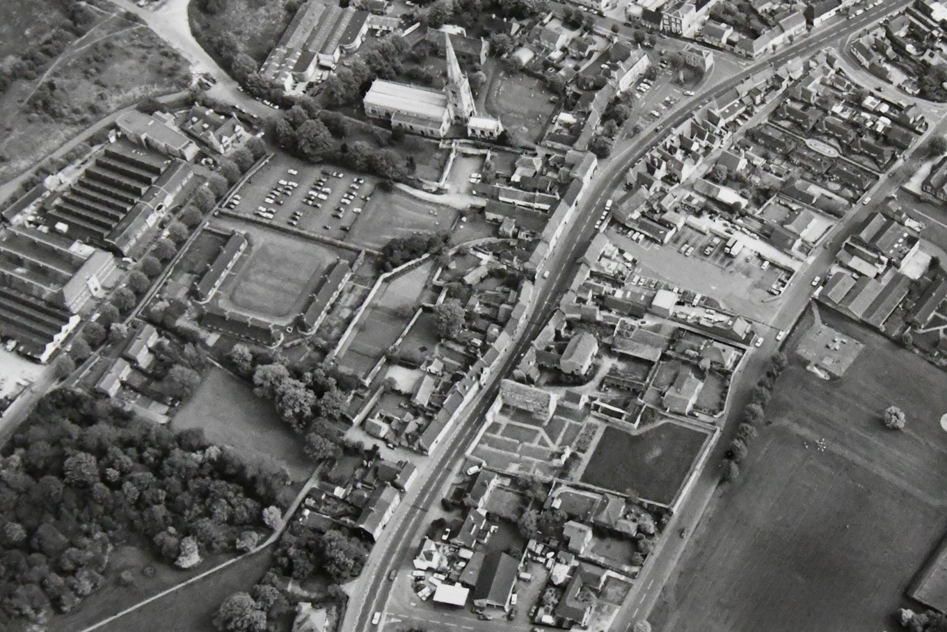
Thanks to a generous grant from the Castle Studies Trust, Museum of London Archaeology (MOLA), will work with Finham Heritage and members of the Higham Ferrers Archaeology and Research Society (HiFARS) to reveal Higham Ferrers’ royal connections through a series of geophysical surveys. We will use a magnetometer to identify any substantial ditches around the castle, as well as the buried remains of internal features such as robbed-out walls, hearths, and pits. Alongside this, the team will use ground penetrating radar to locate the principal buildings of the castle confirming (or denying!) what our documentary sources tell us – that this substantial medieval building included a hall, chapel, tower house, King’s and Queen’s Chambers, not forgetting three substantial gates. Finally, a resistivity survey will be undertaken, with the particular support of HiFARS members, to provide further detailed information on any buried wall foundations or other structural remains. The surveys will be undertaken in the various plots shown in this photograph from the 1980s extending from the church (top centre) to the small wood (bottom left-hand corner).
Aerial photograph of Higham Ferrers NCC9668_004 Reproduced by permission of Northamptonshire HER
Together with the documentary sources, the geophysical surveys will, we hope, shed light on the evolution of the site by:
Seeking evidence of a late Saxon and early medieval manor pre-dating the construction of the castle.
Testing the widespread assumption that a motte and bailey castle was built by William Peveril, who held the manor in 1086.
Attempting to map the layout of the late medieval stone castle.
The findings of the surveys will be considered alongside those of limited excavations in 1992, to see how the castle and its associated buildings fit within the development of Higham Ferrers from a Saxon administrative centre to medieval market town. The results and conclusions will be shared via a public lecture and published as a report on the Castle Studies Trust website.
The final results are in and Dr Andrew Blackler, project lead for the Dating of the Towers of Chalkida, Greece, reveals the surprising findings of the project we funded in 2022 to try and date the hundreds of towers in the region.
In the autumn of 1204 forces of the Fourth Crusade, fresh from their capture of Constantinople, annexed central Greece. Studies have been undertaken of the major fortifications they constructed, but little is known about the hundreds of towers, which are today a ubiquitous reminder to the modern tourist of the medieval period in the region.
The traditional interpretation is that they were built by the incoming westerners- the minor nobility – as part of a process of colonisation, to display and impose their power over the local Greek population. Yet, since no scientific study has ever been undertaken, we could not even be sure when they were built, and therefore why they were constructed or by whom – until now.
Figure 1: Map of Central Greece with Survey area on the island of Evia (Euboea) and the towers sampled (inset)
Following a two-year research program, funded by the Castle Studies Trust and led by Andrew Blackler, a member of the five-year ‘Hinterland of Medieval Chalkida’ survey, surviving towers in central Greece have now been dated using modern laboratory techniques. In October 2022 a team, including technical staff from the Institute of Nanoscience and Nanotechnology ‘Demokritos’ in Athens and from the Ephorate of Antiquities in Chalkida, took samples of wood and mortar from seven surviving towers on the island of Evia (Euboea). This is the second largest in Greece and runs two hundred kilometres down its eastern seaboard. The island, just seventy kilometres north of Athens, is separated from the mainland by a narrow strait only thirty-nine metres wide, the tidal flows of which even Aristotle failed to solve! Chalkida, its capital, became the Venetian administrative centre (as Negroponte) of its Aegean possessions in 1390 and, following its capture by the Ottomans in 1470, their capital of Central Greece for 350 years until the formation of the modern Greek state.
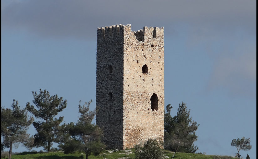
Figure 2. The ruins of a typical tower (Mistros)image description
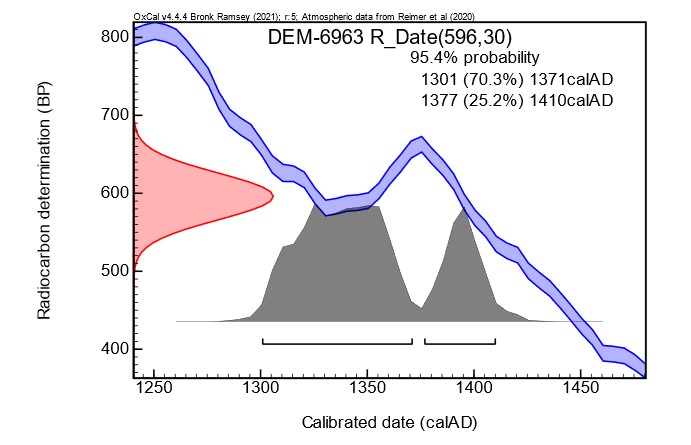
All of the towers (walls about 8 x 8 metres and height up to 18 metres) were in an advanced stage of collapse. Samples were taken of the wood inserted to provide internal lateral structural integrity to their walls, and of the mortar used to bind their rough stonework. This ensured that these materials were not part of a more recent repair or renovation, which would have been the case for beams used to support the multiple floors of the towers, but part of the original construction phase. The ten timber samples obtained were then subjected to a process of radiocarbon (14C) dating, whilst the mortar was analysed using optical and scanning electron microscopy (SEM) and other techniques (pXRF and XRD) at the Demokritos laboratory.
The results have been exceptional. Six towers from different topographic locations (coastal, floodplain, mountain areas) have been dated with 95% certainty to a period between 1270 and 1434. Unfortunately, the accuracy for most samples was only approximately +/- fifty years due to fluctuations in the cosmic concentration of 14C in the earth’s atmosphere caused by solar activity during the fourteenth century: there were therefore two possible dating ranges identified. Two samples were of sufficient quality that, using what is known as ‘wiggle’ analysis, more accurate dating was obtained.
Figure 3. An example of one sample showing the wiggle in the calibration curve, that causes widening of the calibrated ages and splitting of the ranges.
The analysis of the mortar samples also demonstrated that two towers had two phases of construction. It is difficult to know whether this was a deliberate action or simply a reconstruction due to the collapse of the upper levels, given that the region is subject to frequent seismic activity. More importantly, since we could not identify any timber samples for one tower, it was possible to show that the chemical composition of this tower’s mortar was similar to two other towers in its immediate vicinity and thus was possibly also constructed in the fourteenth century.
The general conclusion, therefore, is that all the towers studied were probably built at least a century, or five generations, after the annexation of the region by western forces, and no towers were built immediately after the Crusaders took control. The ’colonial’ interpretation of their role is thus overturned or, at the least, requires reconsideration. Rather, their construction appears to have been a reaction by landowners to increasing instability in the region following invasion of the island by Byzantine forces in the 1270’s, the threat of attack by the mercenary Catalan Company who took control of Thebes and Athens in 1311, and a growing fear of seaborne assault by Turkish corsairs in the fourteenth century.
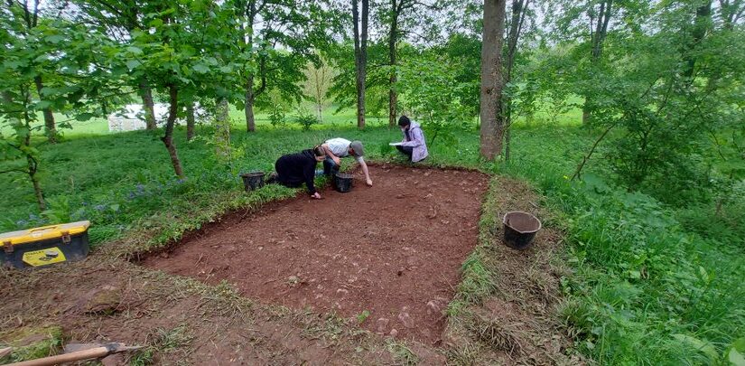
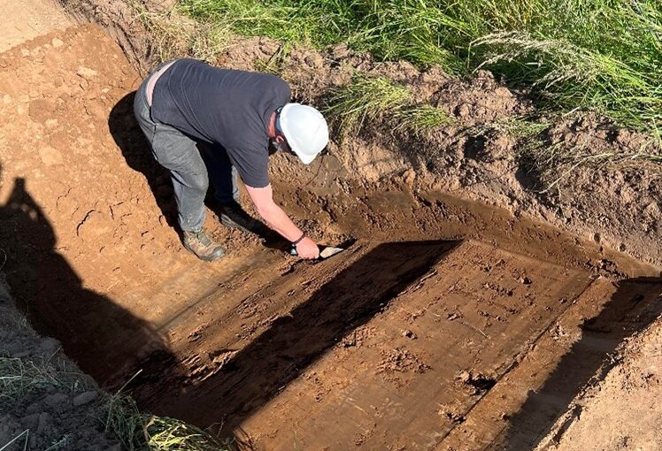
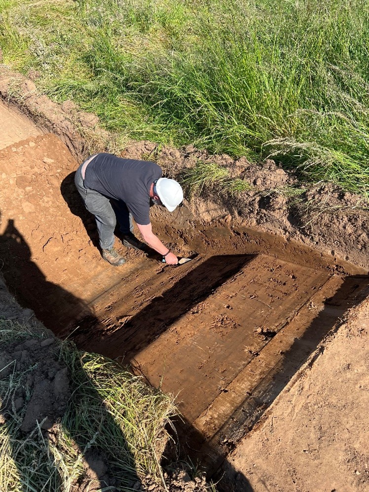
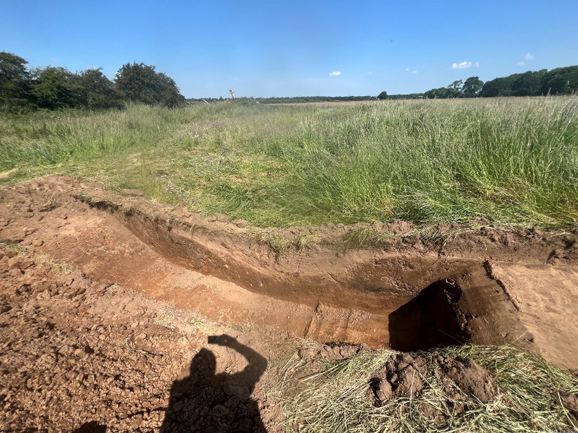
We had found it quite difficult since Monday to find the cut of the ditches from the natural, despite the clarity of their profile from outside of the trenches. While we had the JCB back on site, we thought it would be worthwhile to cut a little deeper into the ditch cuts on both Trench 1 and Trench 2 to determine more about them and their relationship to each other. Certainly, in Trench 1, we seem to have been able to find the extent of the cut and were able to record its measurements and draw sketches which will help us better interpret the nature of the earthworks as a whole. From this, it would appear that the mound was predominantly natural but had been reworked with an accompanying ditch cut around its perimeter.
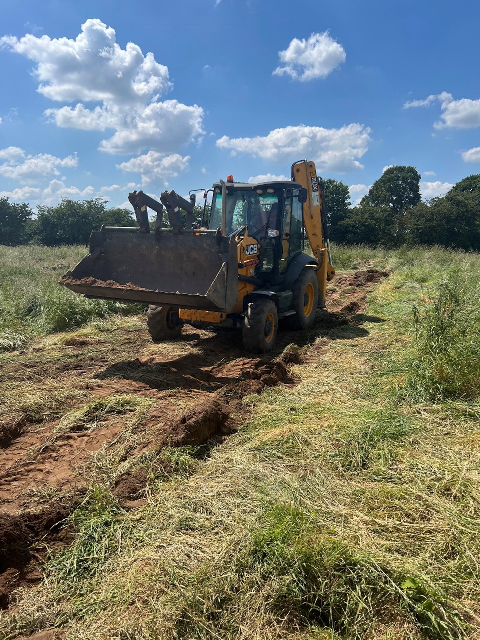
Again, with the aid of our JCB, we set to work backfilling the two trenches and making sure that the site was returned as much to the state it had been in prior to our arrival. After the welfare unit had been collected, we packed up the car with our equipment, and ensured that the finds would be safely transported back to the office ready for the next phase of our project. We also had a visit from the farmer who was able to point out some other features on the broader site that he had been aware, including a much smaller mound to the north in the adjacent field which had existed until it had been ploughed out some years before.
Now that the fieldwork has been completed, we hope to bring you more information in the coming weeks about what we have found. We are hoping that the picture will become clearer in the post-excavation phase, but Newhouse has undoubtedly proven to be a site even more intriguing than we had first thought it to have been.
Figure 1: Digging deeper into the ditch cut in Trench 1Figure 2: The ditch profile in Trench 1Figure 3: Trench 1 and Trench 2 were both backfilled before the end of the day