Following the finishing of excavations at Shrewsbury Castle, the director of the excavations, Dr Nigel Baker, outlines what they found during the dig.
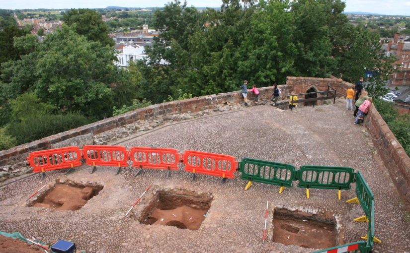
The third season of excavations at Shrewsbury Castle, funded by the Castle Studies Trust and staffed by experienced local volunteers, supervised by Dai Williams MCIfA, and students of University Centre Shrewsbury (University of Chester) under Dr Morn Capper, has just ended. Having investigated the inner bailey interior and one of its ramparts in previous years, the principal objective of this third season has been to examine the top of the motte – more easily said than done as it is paved by cobbles set in thick cement, which had to be drilled through by the volunteers at the peak of the recent heat-wave. The question was: did any archaeology bearing upon the character and use of early medieval motte-top buildings survive the depredations of Thomas Telford, who is known to have demolished a standing 13th-century tower and the ruined walls of at least one major building up there during his ‘restoration’ of 1786-90.
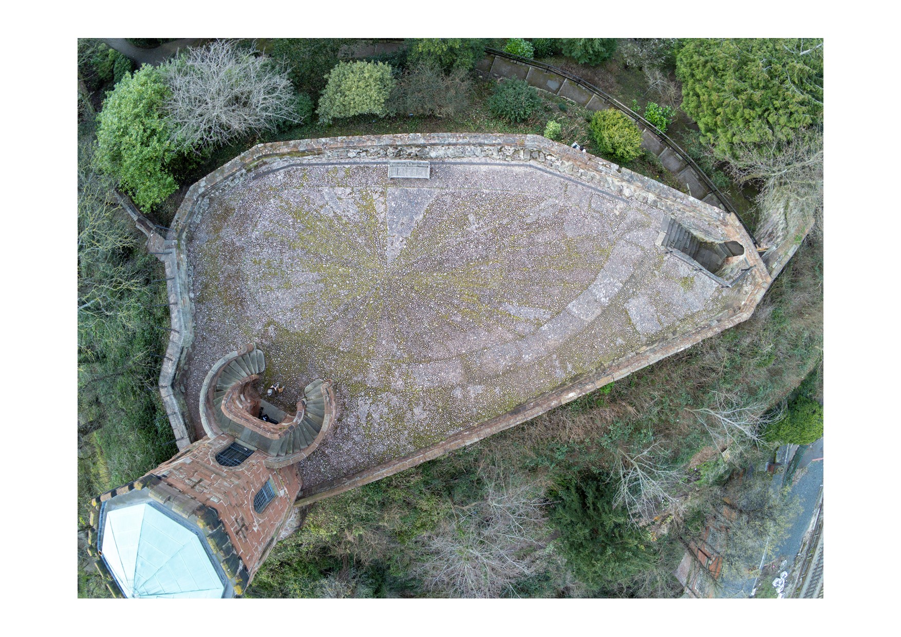
The three trenches on Shrewsbury Castle motte. Copyright Dr Nigel Baker
The answer is that buried archaeology does indeed survive, truncated, under Telford’s topsoil (imported to create a motte-top garden) and the 1990s cobbles. Cut into the orange clay top of the motte were post-holes, a post-pad and slots for sleeper-beams of buildings, generally of the period when local unglazed cooking-pots were in use (late 11th to mid-13th-century). In places these features were intercut, showing that the remains represent buildings that had existed over an extended period of time. Remains of the ‘great tower’, the timber tower that collapsed in the third quarter of the 13th century, were not positively identified. Some of the post-holes were packed with a distinctive crumbly green sandstone (Coed-yr-Allt beds) obtained nearby from the River Severn that has recently been identified as the stone used in the first phase of building the curtain walls and converting the Norman earth-and-timber fortress into a stone castle.
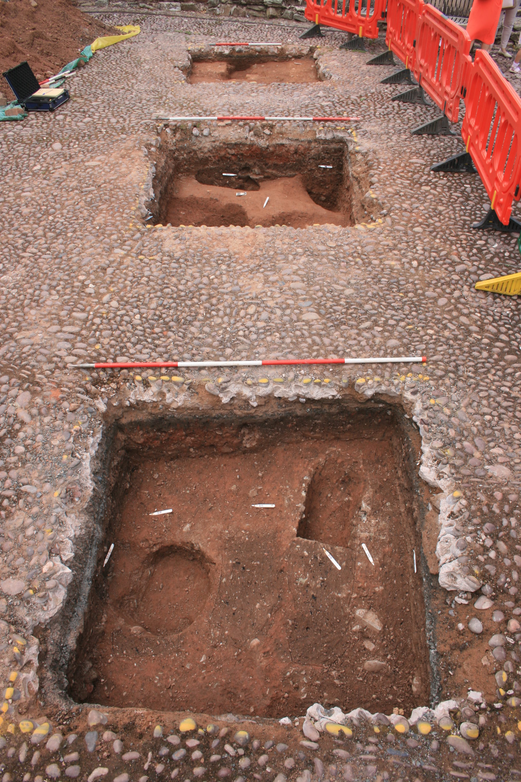
Shrewsbury Castle Excavation opening of the trench outside the curtain wall to investigate possible remains of a bastion. Copyright Dr Nigel Baker
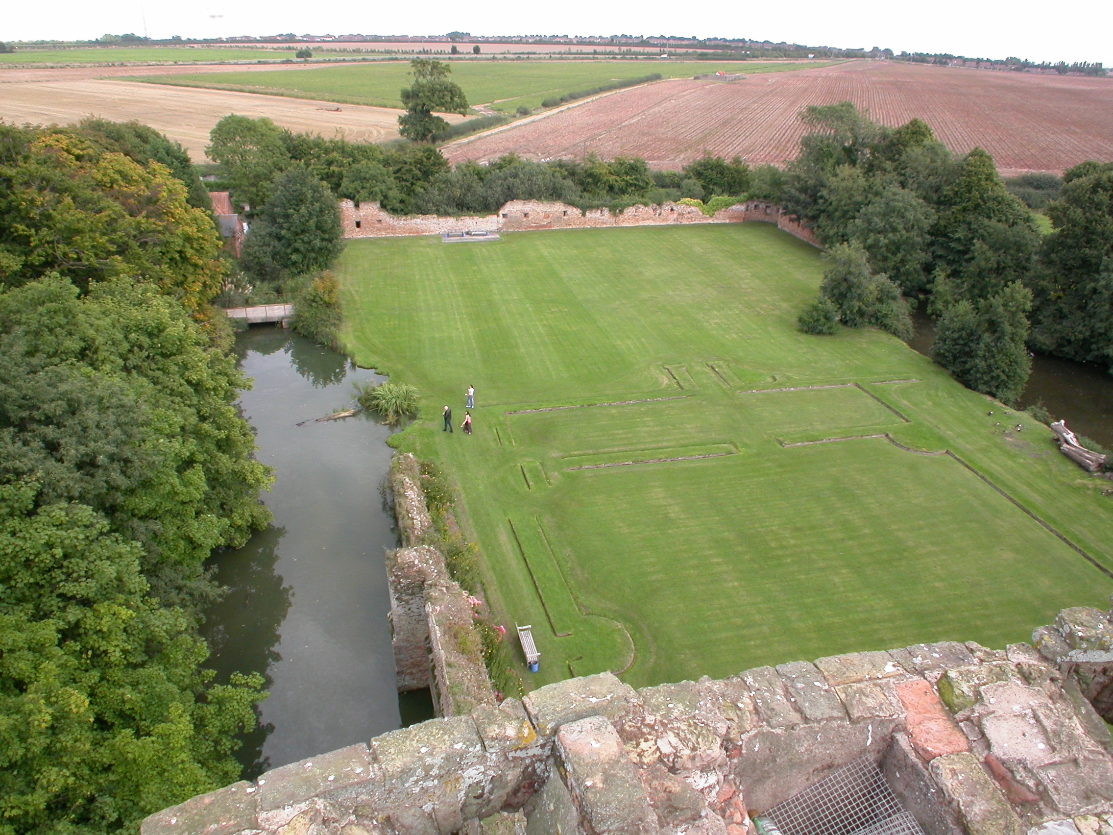
A second trench was also opened outside the north curtain wall to look for evidence of a projecting bastion in that area that is known to have still been standing in the 18th century. The wall itself shows no trace whatever of this, suggesting that its outer face was rebuilt in the mid-19th century. The ground outside the curtain wall was found to have had been stripped down to natural in the 19th century when the wall was indeed rebuilt. Concurrent research by Historic England in its registry files suggests this is not in the least surprising as the curtain walls evidently have a long history of instability and collapse.
Following three seasons of CST excavations and additional research for a conservation management plan commissioned by Shropshire Council, the site owners – including the first-ever examination of the curtain walls with dense vegetation now removed from their faces – attention is now turning to publication of this long-neglected Marches shire-town fortress.
Back in May the geophysical of survey took place at Pontefract Castle. Find out what they were surveying and the various techniques they were using to achieve the best results
You can find more about the different geophysical survey techniques in the article we published back in January 2021 by our geophysical survey specialist assessor Kayt Armstrong:
While here is a short taster video of a project yet to properly start – dating the towers of Chalkida in Greece. With permissions having been granted by the Greek government, Dr Andrew Blackler outlines what they will be doing when the fieldwork gets underway in September.
Dr Nigel Baker, Excavation Director of the Shrewsbury Castle Excavation 2022 outlines what he hopes him and his team hope to find over the next two weeks with the main focus on the previously unexplored motte.
A third season of excavation funded by the Castle Studies Trust is about to begin at Shrewsbury Castle. In 2019 a trench was excavated across the interior of the inner bailey and in 2020 an inner bailey rampart was sampled. Attention has now turned to the top of the motte, and to the north curtain wall. The excavations, the first ever to take place at the castle are carried out by a team of local archaeological volunteers under the direction of Dr Nigel Baker and David (Dai) Williams together with students of University Centre Shrewsbury (University of Chester) led by Dr Morn Capper.
The motte top excavation will establish just how much damage Thomas Telford did to the medieval motte when he was modernising the hall and landscaping the castle in 1786-1790. Ruins on the motte top were cleared to make way for a Gothic summerhouse known as Laura’s Tower, with a garden laid out around it. The team will be looking in particular for surviving evidence of the Tower of Shrewsbury, the timber watch-tower, assumed to be of 11th-century origin, that is known to have collapsed in 1269-71.
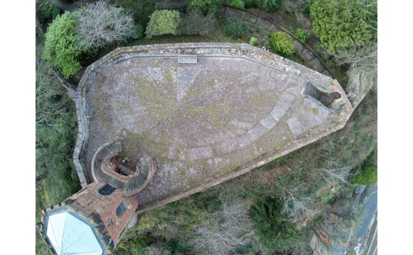
Vertical view of Shrewsbury Castle Motte (copyright James Brennan Associates)
The irregular plan of the motte top seen in the drone photo (undertaken by James Brennan Associates for the current conservation management plan for Shropshire Council, the site owner) arises from a number of factors. Originally probably oval, the straight line across the bottom of the picture is a pale sandstone wall with red sandstone stripes built, probably by Edward I’s masons, across the damaged side of the motte after a landslip into the river below in the 13th century. Laura’s Tower occupies the bottom left corner, set off-centre on the base of a 13th-century tower demolished by Telford. The lobed shape of the motte on the left of the photo results from at least two phases of medieval building incorporated in the retaining walls: an angled structure with a high chamfered plinth and recessed masonry panels, superimposed over a projecting curving rubble footing. These remains were seen and recorded for the first time this year as part of the ongoing CMP work.
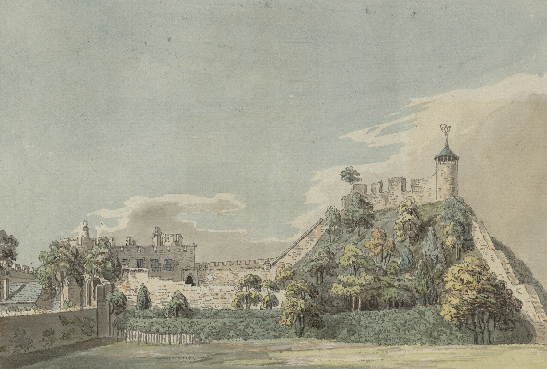
Antiquarian (18c) image of Shrewsbury motte showing what looks like the base of large windows possibly from a first floor Great Hall
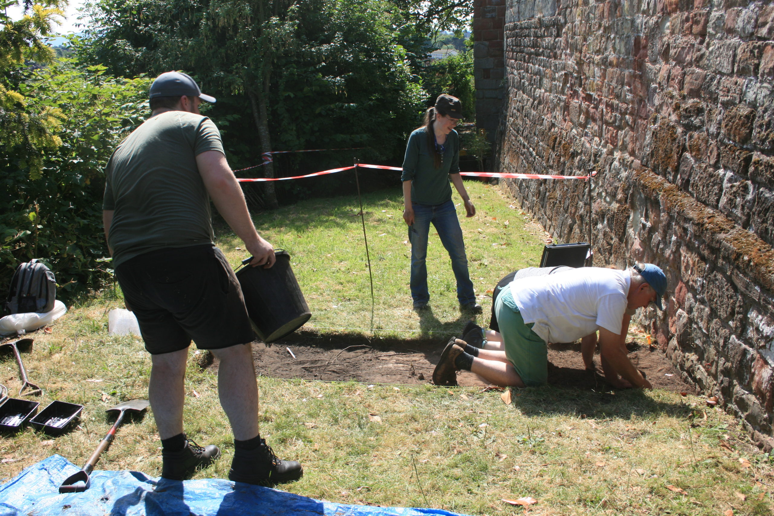
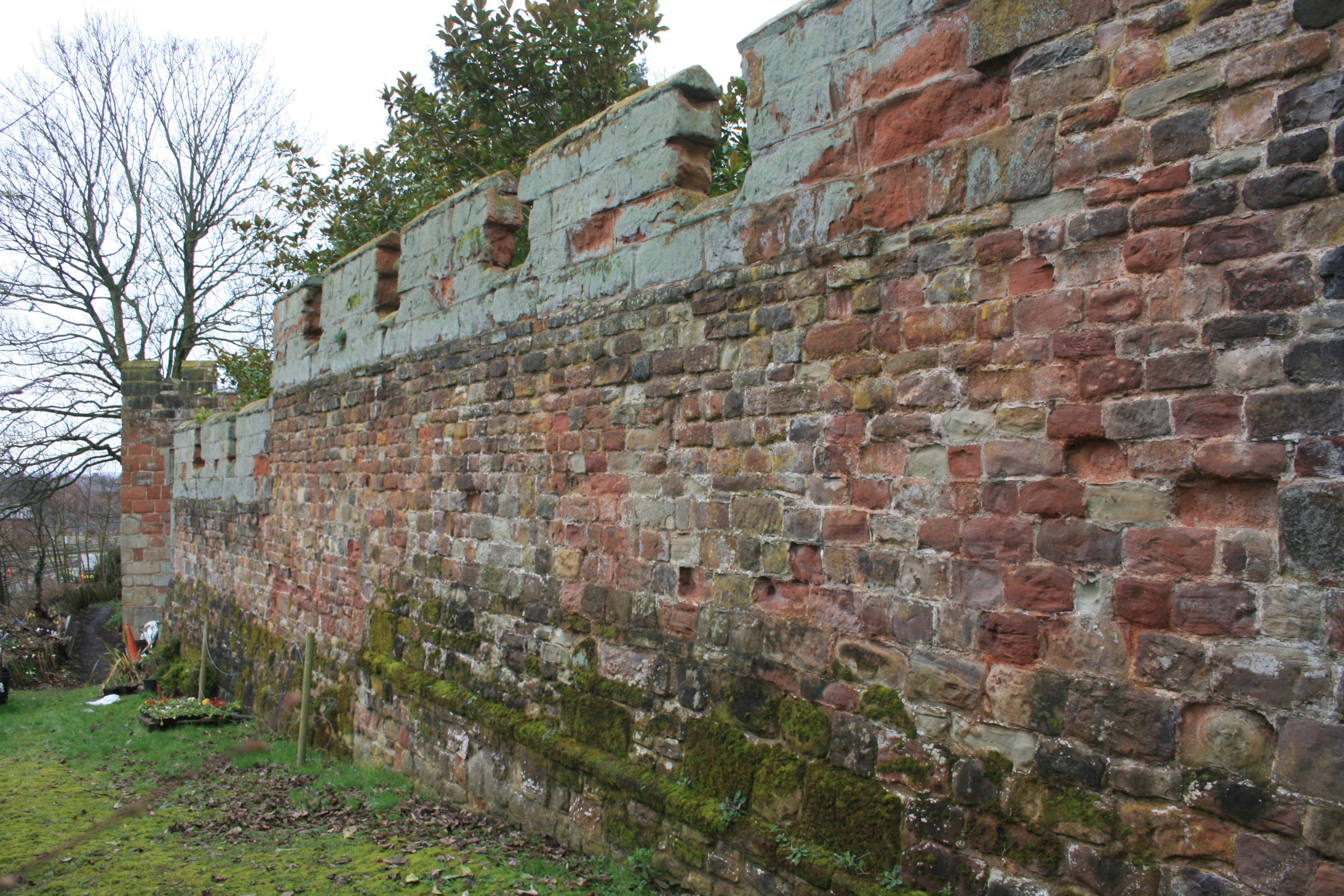
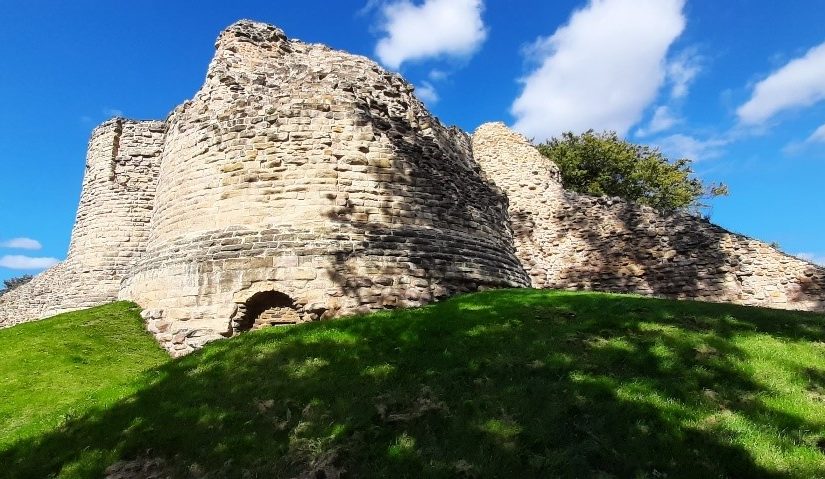
A second trench is to be opened on the north curtain wall. A long stretch of this wall is unusually consistent in its fabric, with small, squared rubble and two offset courses. 18th-century illustrations show however that a projecting bastion formerly stood in this area, of which no trace can be seen in the standing masonry. The suspicion is that a major part of the wall here has been rebuilt, and the trench is designed to explore this question – and to establish the nature of the surrounding stratigraphy.
Part of the north curtain wall of Shrewsbury Castle. The even coursing apparent over this long stretch of masonry is at odds with the complex fabric visible elsewhere in the wall and with 18th and early 19th-century illustrations showing a projecting bastion in this area. Excavation will seek to confirm whether or not this stretch has been rebuilt, and to locate in plan the features seen in the illustrations. Copyright Nigel Baker
In addition to an introductory display to be mounted in the on-site marquee, there will be two further displays in the town running concurrently with the excavations. In Shrewsbury Museum & Art Gallery in the Square, Dr Capper’s team is assembling a display featuring artefacts found in the first two seasons, while in Castle Gates Library (the former Grammar School buildings) a display is in place that explores the evidence for the former castle outer bailey, within whose perimeter the library stands.
The excavations run from July 18th to 28th. Visitors are welcome every day except those when the castle is closed (Thursday 21st and Thursday 28th).
Vicky McAlister, project lead of the Geophysical Survey of Kilmachill explains the reasons behind the survey.
“Can we use drone (UAV) gathered imagery to see how spaces around castles were being used?” This was the question that spurred the addition of geophysical survey to a wider study of the landscape surrounding the deserted medieval settlement complex at Kilmacahill, County Westmeath. The data will then be delivered to the Human-Environmental Exchanges in the Landscape (HELM) project team for analysis to detect possible subsurface archaeological remains. HELM is led by project co-Principal Investigators Dr. Vicky McAlister and Dr. Jenny Immich, with Target Archaeological Geophysical GVC commissioned to undertake the survey.
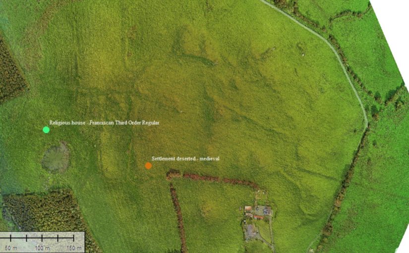
Kilmacahill was selected for this interrogation because of its layered landscape history and good above surface archaeological remains. The vernacular settlement site of Kilmacahill is adjacent to a Franciscan Third Order Regular monastery and within visual range (c. 1km) of Joanstown motte and bailey, located to the west of the site. The work at Kilmacahill already undertaken includes UAV collected aerial photographs and topographic data over the deserted settlement complex for analysis in geographic information systems (GIS) software.
Geophysical Area 1
In its first project phase (2019-2021) HELM addressed the theory that Anglo-Norman medieval vernacular settlements could be found in close physical proximity to elite secular and religious sites. More specifically, we hypothesised that peasant settlement could be found clustered around castle sites, parish churches, and monastic sites. To test this theory, HELM analysed UAV-gathered data for four castle sites in counties Limerick and Tipperary. At three of these four sites we found what we interpreted to be burgage plots clustered in the area between the castle and parish church. One of them, Glenogra in County Limerick, looked to have a deserted medieval village showing different areas and types of house plot compared to the very planned and regular appearance of such plots at the other sites. We wondered if this indicated that both Anglo-Norman settlers and Gaelic Irish tenants were living in this settlement.
Geophysical Area 2
This led the HELM team to begin phase two of the study, which is looking at three potential deserted medieval settlement sites in County Westmeath: Fore, Kilbixy, and Kilmacahill. Westmeath was the contact zone or frontier between the Anglo-Normans and Gaelic Irish for an extended period of time. This duration made us interested in what the medieval settlements associated with castles there looked like morphologically: more like Glenogra and haphazard, or something else entirely?
In late 2021, thanks to funding from the American Philosophical Society, Dr. Paul Naessens of Western Aerial Survey collected data from UAV flights at these three sites. At one of them – Kilmacahill – he also tested a new addition to the arsenal of digital archaeologists: UAV-mounted multispectral cameras. Multispectral data is traditionally used by scientists as an effective tool to examine soil productivity and plant health. In archaeological contexts, multispectral imagery can be analysed to reflect relative differences in vegetation health as a proxy to indicate near-surface or subsurface anthropogenic features – such as field boundaries made of stone, pits with charcoal in them, crushed gravel pathways, or other architectural features. The vegetation above these man-made features appears not as healthy as that above natural ground in the data analysis. The UAV-gathered photogrammetry data showed some interesting house plots, but also details of a complex circular enclosure not listed on the Sites and Monuments Record.
Geophysical Area 3
The HELM team agreed that concentrating our resources on one site would help to test our methodology and thus we applied to the Castle Studies Trust for funding for geophysical survey. We hope that the combination of three methods will tell us the most about vernacular settlement located between the Franciscan house at Kilmacahill and the motte castle at Joanstown. We will also be able to test the robustness of our UAV-based methodology against geophysics, which is much more expensive but is standard practice for identifying low-lying archaeological features. Geophysics currently costs up to ten times the amount of flying a site with a drone, so if we are successful in using UAV data to identify castle features, then this will be good news for everyone seeking to know what’s going on around their sites!
The data produced by the three collection methods (UAV photogrammetry, multispectral, geophysics) will be incorporated in GIS software to create a visual of the immediate subsurface archaeological remains of the DMV and will uncover finer features of the site as a whole. The HELM team should have the exciting results of the surveyed area by Autumn 2022.
Ian Downes from Wakefield Council looks at the geophysical survey being carried out week commencing 9 May 2022 on parts of Pontefract Castle yet to be explored archaeologically. The work, funded by the Trust is being carried out by Wessex Archaeology.
Pontefract Castle in West Yorkshire is a Norman motte and bailey castle, built upon a Saxon royal palace, and used extensively during the English Civil Wars, when it suffered three prolonged sieges. In that time, it went from being the property of a Norman Baron, to a powerful Dukedom, to the principal royal castle of the North of England.
At the end of the Civil Wars the castle was pulled down by the people of Pontefract by order of Parliament. The site was initially used as a market garden before it was leased by the Dunhill family for the cultivation of liquorice. Finally, it was converted into a park in 1880. To this day the site remains a park and major tourist attraction in the town.
Now managed by Wakefield Council on behalf of the Duchy of Lancaster the castle has recently undergone a thorough restoration project seeing the ruins conserved and new visitor facilities created.
Parts of the site were excavated in the 1880s and again in the 1980s. More recently, work commencing in 2017 to restore the site saw new areas excavated including the Gatehouse.
The Keep of Pontefract Castle courtesy of Wakefield Council.
As the Victorian excavations weren’t fully recorded or published, and more recent archaeology has been focused on areas where construction and conservation has taken place, this has left many parts of the site relatively unexplored.
The two areas we will be looking at as part of this project are the area from the Kitchens through to the Royal Apartments within the Bailey; and the northern ramparts below the royal apartments.
The first of those two is where a series of “service buildings” were sited according to historic maintenance records for the castle. We know little more, but it was probably also the site of a gatehouse leading to a walkway to the Swillington Tower. We hope this project will find some evidence of the footprint of the buildings, possible locations of fireplaces and to get an indication of how much survives below ground.
Area occupied by the service buildings between the kitchens and Royal Apartments. courtesy of Wakefield Council
The second area to be investigated is an area outside of the curtain wall, which was subjected to heavy bombardment during the three sieges. This may also be the location of a medieval garden, again mentioned in historical records, and Victorian walkways and paths.
This area should include the bottom section of the walkway from the bailey down to the Swillington Tower. We hope to answer questions such as whether the earth mound at the side of the tower covers the remains of this walkway and how much of it survives under the start of the ramparts.
The site has seen little activity since the Victorian paths were laid, with that area falling into disuse relatively quickly. This lack of later use raises the potential for evidence of all these things, but most excitingly the possibility of pinpointing further evidence of Civil War activity.
The outer ramparts looking from the Queens Tower back towards the Swillington Tower.
The project will see specialists from Wessex Archaeology conduct various forms of geophysics on the two areas including resistivity, magnetometry and ground penetrating radar. The use of multiple techniques has been chosen to maximise the potential for making discoveries with the potential for quite complex buried remains being high.
Following the publication of the results of our Warkworth geophys survey, here is the second of the Trusts 2021 grant awards publishing their results on the building survey of Greasley Castle, Nottinghamshire . Here James Wright explains what he found during his survey.
When studying castles, it is important to try and understand the contemporary experience of the buildings in the mediaeval period. A good way to do this is to look at castles which fit into the background. Researching castles built for kings, dukes and archbishops can skew data towards extraordinary structures. Equally, castles built in contested borderlands can lead to a focus on military aspects which were perhaps not part of the everyday for most sites. Surveys of lordly sites in the English midlands can help to establish a framework which explains the commonplace context for most castle builders.
The research funded by the Castle Studies Trust at Greasley Castle (Nottinghamshire), a relatively obscure site, has afforded the rare opportunity to look at a fourteenth century baronial castle in the midlands. The castle built in the 1340s for the socially rising Nicholas de Cantelupe was probably a type instantly recognisable to many of his aspirational peers.
Cantelupe’s story was a familiar one. Born at the opening of the fourteenth century into a family with high-ranking connections – two of his uncles were bishops – he engaged in royal service through military campaigns in Scotland, Flanders and France. Cantelupe was then appointed Governor of the key border town of Berwick-on-Tweed, named commissioner of array in Lincolnshire and became an MP. In short, Cantelupe was exactly the sort of thrusting individual who built castles to physically cement a place in society through powerful architectural statements.
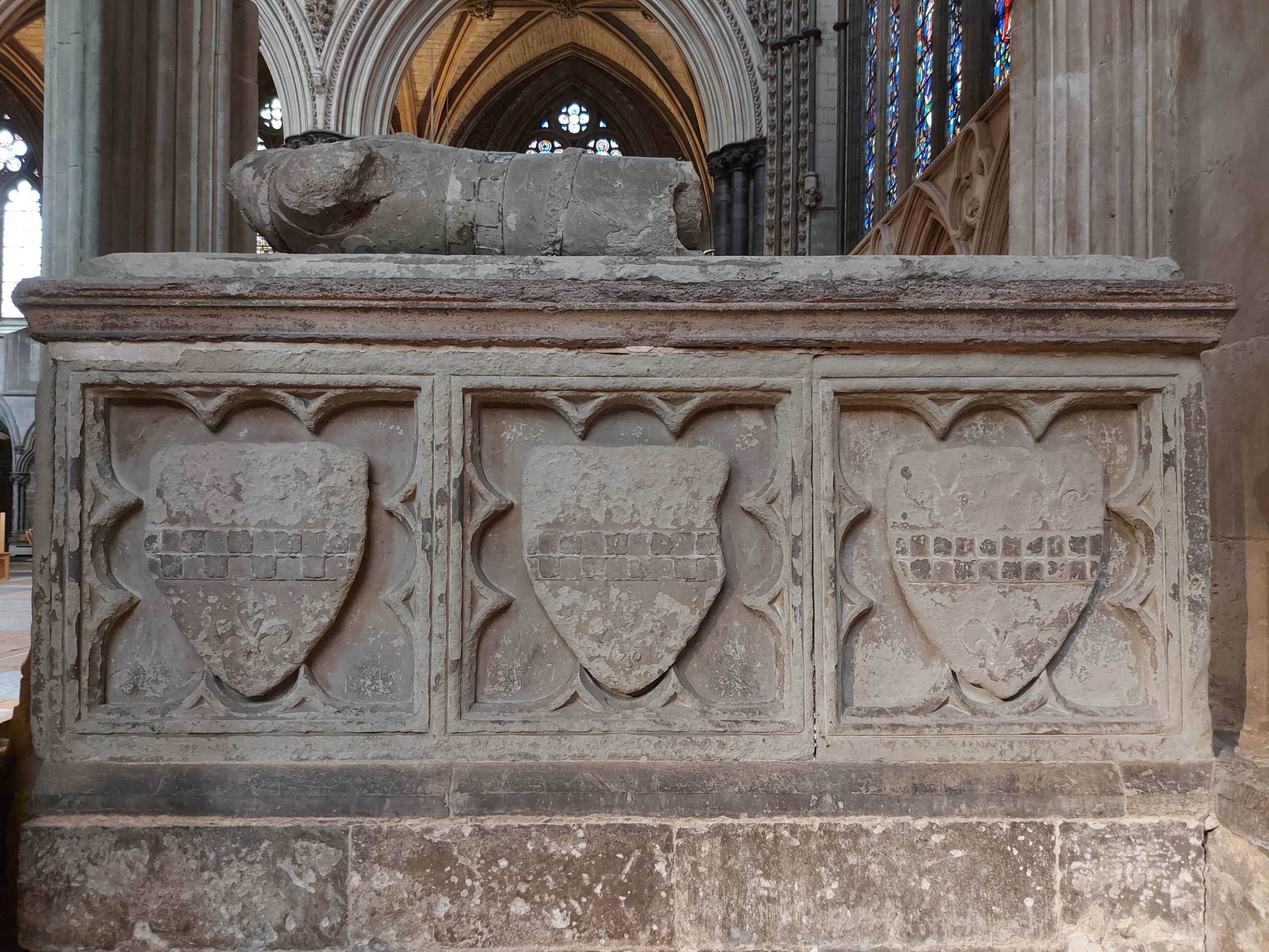
Tomb of Nicholas de Cantelupe at Lincoln Cathedral (Picture Source: James Wright / Triskele Heritage)
Some scholars have pointed towards Edward III’s grant of a licence to crenellate at Greasley, which Cantelupe received in 1340. However, after that note, references to the castle largely dry up. This is probably due to what the castles specialist, Oliver Creighton referred to as a “deficiency of the field evidence”. The site, a privately owned working farm, has not received much in the way of systematic survey work. Consequently, previous statements were rather scanty – it was a misunderstood castle.
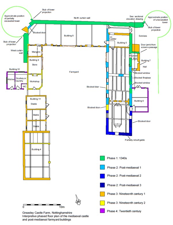
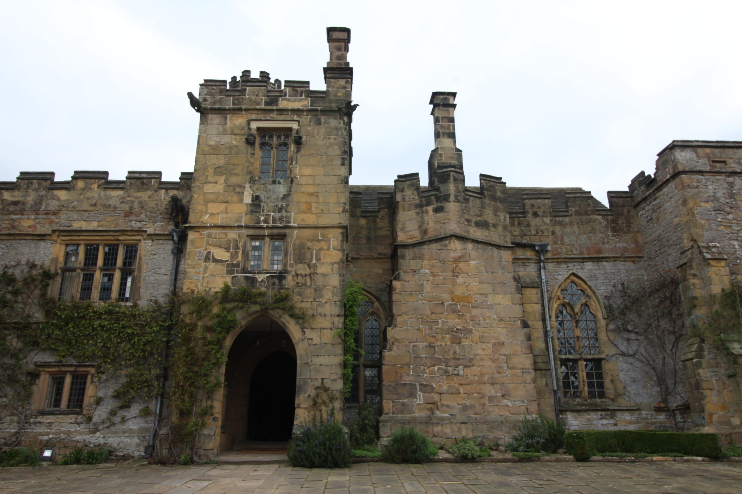
The project was able to identify that the remaining structures of the castle are located within a post-mediaeval farmyard, which lies inside a partially moated plateau. The remains of a single courtyard were identified. To the north, it is bounded by a plain curtain wall flanked bywhat were probably polygonal turrets. Part of the west curtain wall survives beneath nineteenth century farm buildings. Opposite is part of the east elevation of the great hall. Analysis revealed that a mid-fourteenth century moulded doorway allowed access into a screens passage with the hall opening to the south. Internally, this space was lit by two tall, flat headed, twin-light, double-cusped tracery windows that flanked a recessed fireplace. To the north of the hall, a stretch of ashlar wall culminates in the closer rebate of a door into a service range which probably incorporated the north-east turret.
Interpretive phased plan of Greasley Castle, Nottinghamshire (Picture Source: James Wright / Triskele Heritage)
The former magnificence of Greasley can be alluded to through the identification of the substantial timbers re-used in the roof structure of a post-mediaeval barn, alongside the exsitu architectural stonework which peppers the farm structures. The latter includes carved head sculptures, tracery windows, a moulded coping, a door arch and the crown of a sexpartite vault. When considered alongside the in situ great hall door and windows, it is clear that this was once a very well-appointed castle.
Greasley in Context
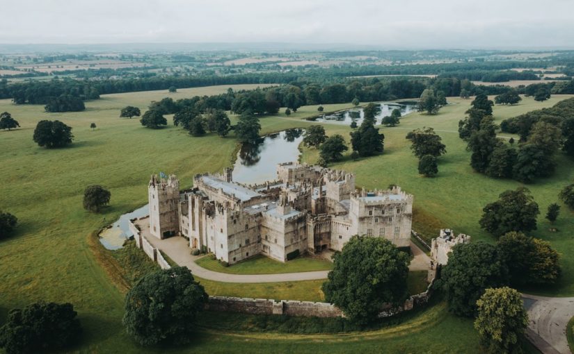
With something of the plan of Greasley established, it has been possible to try and set the castle in its wider context. Cantelupe was one of several late mediaeval midlands men who sought to bolster their social position through the patronage of courtyard castles. The pattern of Cantelupe’s biography and architecture can be paralleled in the second quarter of the fourteenth century by the Vernon family at Haddon Hall (Derbyshire) and in the 1350s by Sampson de Strelley at Strelley Hall (Nottinghamshire).
Exterior of the entrance passage and great hall at Haddon Hall, Derbyshire (Picture Source: James Wright / Triskele Heritage)
Haddon is perhaps the closest parallel to Greasley in terms of landscape and architecture. Both are directly overlooked by hills to the north. The moated plateau at Greasley is 0.91 hectares in area and the double courtyard and terraced garden at Haddon are 0.76 hectares. The projected area of the great hall at Greasley (at least 57m2) is proportionate to that of Haddon (67m2) and the layout of the two – with tracery windows flanking early examples of recessed fireplaces – seems similar. Meanwhile, the probable area of the Greasley courtyard (1026m2) is comparable to Strelley Hall (1074m2). Strelley had rectangular corner turrets, whilst Greasley is likely to have had polygonal examples which can be paralleled in the mid-fourteenth century at sites including Stafford Castle and Eccleshall Castle (Staffordshire). Furthermore, the probable relationship between the services and one of the corner turrets at Greasley can be mirrored in the 1380s Drum Tower at Bodiam.
The reasons for the decline of Greasley are, like so many other late mediaeval castles, bound up with the varied fortunes of the families that owned them. For example, the ruin of nearby Strelley was brought about via a five-way division of the estate at the end of the fifteenth century which led to decades of expensive litigation, legalwrangles with neighbouring families and a catastrophic fire. Greasley was inherited by the Zouche family during the 1370s, but they eventually lost it due to the attainder of John Lord Zouche for his support of Richard III at Bosworth. There is no architectural evidence for any mediaeval construction after the original mid-fourteenth century phase and it may be that the later owners either did not remodel the castle or let it deteriorate. By the late sixteenth century the site was a roofless tenant farm.
Greasley Castle Farm in 2021 (Picture Source: James Wright / Triskele Heritage)
Conclusions
Understanding the depreciation of Greasley from courtyard castle to working farm has been key to understanding this misunderstood site. By using buildings archaeology to unpick the later accretions from the surviving built environment of the castle, it has been possible for the plan form of the mediaeval architecture to be established for the first time.
Although a pale shadow of its former glory, Greasley can now be understood as a turreted courtyard castle with a fine great hall and associated services. The site was built for a socially rising aristocrat whose architectural patronage fitted well within the experience of his midland peers. It is intriguing to consider that Greasley may once have rivalled the rightly famous Haddon Hall in its heyday.
Featured Image: Buildings archaeology survey work on the exterior elevation of the great hall at Greasley Castle, Nottinghamshire (Picture Source: James Wright / Triskele Heritage)
About the author
James Wright of Triskele Heritage is an award-winning buildings archaeologist. He has a long-lived research interest in mediaeval castles, palaces and great houses. He has worked on surveys of buildings including the Tower of London, Nottingham Castle, Knole, Holme Pierrepont Hall and the Palace of Westminster. He has written books on Tattershall Castle, Kings Clipstone Palace and the castles of Nottinghamshire. James led the building survey, funded by the Castle Studies Trust, at Greasley Castle.
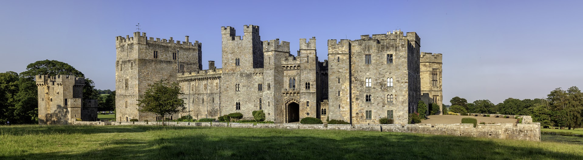
The team at Raby Castle were delighted to hear that their application to the Castle Studies Trust for funding to support the creation of a digital model of the 14th century Nevill stronghold. The acual survey to create the model will not take place until May, but preparation is well underway including extensive documentary research by volunteeers. Their curator, Julie Biddlecombe-Brown who will oversee the project during 2022 reflects here on what the project will entail and what they hope to achieve.
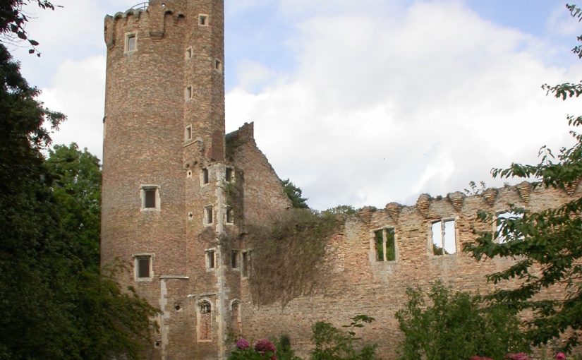
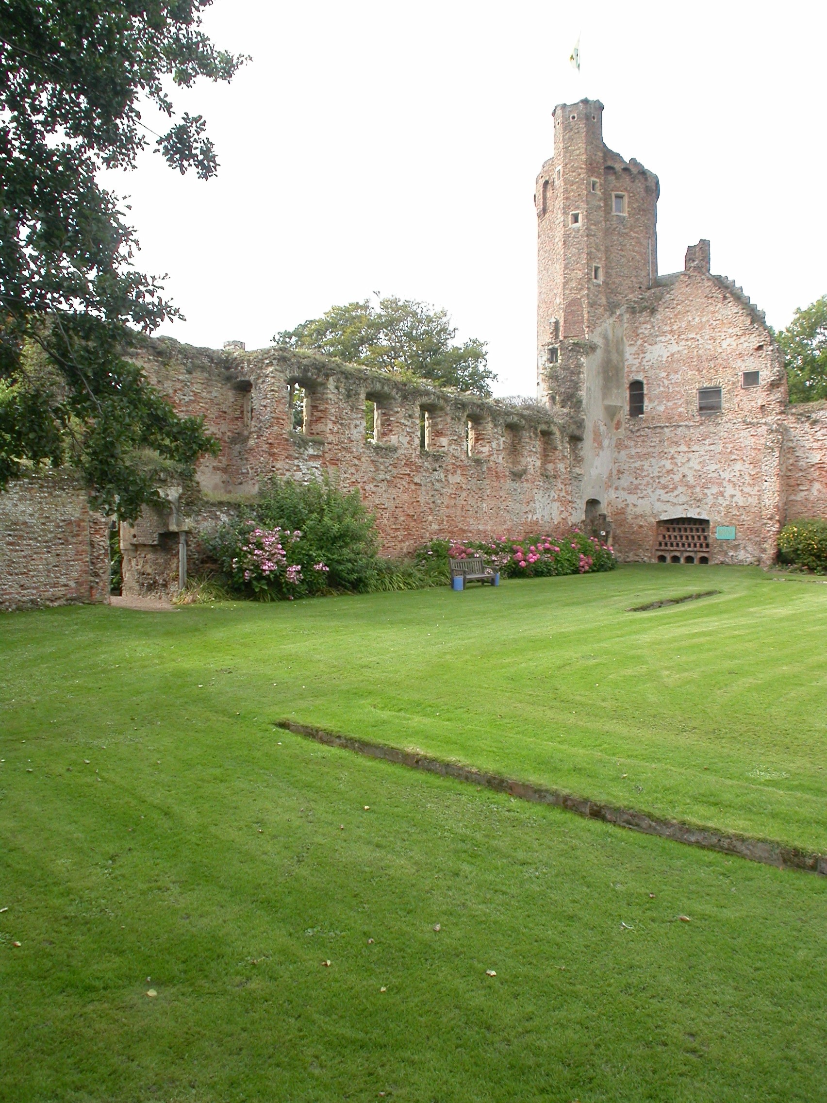
Raby Castle is one of the most impressive intact castles in the North of England. Built in the 14th century by the powerful Nevill family, it has a fascinating history. The castle was seized by the Crown in 1569 after the failed ‘Rising of the North’. In 1626 the castle was purchased by courtier Henry Vane the Elder and has remained in the family ever since. Over the last 300 years, successive generations have altered, updated and modernised parts of the building and although from the exterior, the 14th-century core is still evident, internal reworkings of the spaces mean that it is sometimes difficult to imagine and interpret the castle’s medieval past.
West Side of Raby Castle copyright Graeme Peacock, Raby Castle
In 2016, the castle was inherited by Harry Vane, Twelfth Baron Barnard. Under his stewardship, ambitious development plans were passed to enhance the visitor journey at Raby Castle, Park and Gardens. The dynamic scheme known as The Rising will restore and preserve historic buildings which have been without purpose for decades, providing contemporary event and exhibition spaces, retail and dining experiences and a visitor’s hub. The transformation of the visitor offer at the castle, park and gardens include improved interpretation of the castle building. An important part of this for the Raby team is increasing our understanding of how the castle functioned during it medieval heyday. In 1378 Bishop Hatfield granted John Nevill a licence to crenellate reflecting a building that was changing from a fortified manor house to the castle we see today. Less than 50 years later, John’s son Ralph arranged the betrothal of his daughter Cecily to his young ward, Richard Duke of York; a marriage that would play a central role in the Wars of the Roses and ultimately in shaping British history.
With no significant collections in the castle to reflect this period, Raby’s greatest medieval asset is the castle itself. Alterations over the past 400 years have reshaped the building, modernising it for residents as tastes and technologies changed. Whilst it is still medieval in appearance, key features of the 14th century building have been lost. In order to explore how the castle may have looked before these alterations, our 2022 project will create a digital model of the castle that allows visitors then to view the castle’s past appearance based on our ongoing research.
The creation of the digital model will be carried out by Durham University’s Archaeological Services, using a DJI S900 drone or equivalent. Photographs will be taken utilising a 14mm lens and 36 megapixel sensor, supported by RTK GNSS positioning. The data captured will then be uploaded and processed through Agisoft Metashape Professional and output as a 3D model utilising AutoCad Map 3D and giving the team the opportunity to ‘strip back’ known later additions and ‘rebuild’ known, lost features, such as the Barbican. The resulting model will be used in new interpretation at the castle, sharing our findings with our visitors.
Instrumental to the success of this project will be a team of Raby’s dedicated volunteers. A group of the castle’s regular volunteers formed a research group to work with the curator to pull together all known sources for the castle’s architectural changes to support this project. They have researched documentary sources including primary and secondary accounts, topographical pictures, maps and plans and in advance of the project will be surveying the castle walls. Their findings will be brought together in a portfolio of evidence which can then be reviewed by specialists from Durham University Archaeological Services who will be carrying out further research and eventually creating the model itself.
There has never been a full archaeological survey of Raby Castle and opportunities for research have been limited in the past. This project reflects the ambitions and vision of Lord and Lady Barnard, the castle’s owners who firmly believe that it is by understanding and sharing the castle’s past that we will secure its future. This project is part of that important story.
Castle Studies Trust patron John Goodall explains the reason behind his latest book The Castle (Yale University Press) using the intriguing example of what happened to Caister Castle after the death of Sir John Fastolf, the castle’s owner.
Those who have seen a copy of The English Castle (2011), which I published more than a decade ago, may be surprised to learn that it was originally intended to be a short book. The attempt to tell the story of the architectural development of the castle from the Norman Conquest of 1066 to the Civil Wars of the 1640s, however, inexorably and necessarily transformed it into a long and richly illustrated one. So long and so richly illustrated that, when it was completed, I never thought I would wish to return to the subject.
Several friends and at least one reviewer, however, observed that the story it told about the history of the castle was incomplete. If the castle was—by my own definition—the residence of a noble made magnificent by the trappings of fortification, then what was there to say about such buildings in later centuries? They were right, of course, and this new book The Castle. A History is an attempt to complete a story that my previous book—for all its length and scale—only partially told.
Caister Castle Bailey from the Great Tower copyright John Goodall
Rather than continue the narrative in the same form, however, and produce another door-stopping volume, I thought I would try and condense the whole story of the castle from beginning to end in a single and much shorter volume. In this sense, this second book on the subject of castles is actually cast in the intended form of the first that I planned more than a decade ago. To make this possible I also decided to approach the subject in a way that I hope will strike readers as both unexpected and engaging.
Presented here are effectively a series of anecdotes organised in a huge chronological span of two millennia and drawn from every kind of source, from chronicles to sermons, poetry to building accounts, and novels to correspondence. All of them are about castles or take place within the context of these buildings. There are also some images that are treated in the same way. The result is a story presented through many different modes and voices across a span of over two millennia.
Part of the joy of this approach is that the book can be read in many different ways, either as a volume that the reader can dip into casually at any point or as an overarching narrative. More importantly, however, it allows for the exploration of specific detail in a way that is impossible in a conventional narrative history. In the process, the human dimension of the past is also brought to the fore. As an added benefit it allows for the exploration of small episodes and the specifics surrounding them that would be impossible in a conventional narrative history.
What could be better as a taster for the volume, therefore, than take a relatively well known anecdote about a siege that didn’t make the final cut for reasons of length and present it in the formula adopted in the book.
Caister Castle Great Tower from the Bailey copyright John Goodall
In the autumn of 1459 the childless Sir John Fastolf, a wealthy veteran of the French wars, tried from his deathbed to finalise the details of a long-discussed proposal to turn his seat at Caister—variously described as a ‘great mansion’, ‘castle’, ‘manor’ and ‘fortress’—into a Benedictine Priory and almshouse. When he died on November 5, his trusted administrator John Paston announced that Sir John had issued a final will by word of mouth. This nuncipative will gave Paston control of all Sir John’s property and tasked him with founding the priory. We will never know the truth of Paston’s assertion. Given the value of what was at stake, however, not to mention England’s descent into the Wars of the Roses, it was never going to go unchallenged.
After the Battle of Edgecote on July 26, 1469, Edward IV was briefly imprisoned and royal authority collapsed. A wave of violence broke as individuals across the kingdom took the opportunity to settle scores. Among them was the Duke of Norfolk, who decided to seize Caister by force. The ensuing siege lasted about three weeks and details of it are recorded in the writings of a former secretary of Sir John Fastolph, the scholar, historian and topographer, William Worcestre. He was an excluded executor of Sir John’s will:
Memorandum that at the feast of the Assumption of the Blessed Mary [15 August] 9 years ago was the siege of Caister; Saint Bartholomew’s [Day, August 24] was a cruel day with guns fired at the castle [castrum]; the siege lasted for five weeks and three days.
Here follow the names of the men at arms besieging the castle and fortalice [castellum et fortalicium] of Caister Fastolf, beginning on Monday, [August 21] before the feast of Saint Bartholomew in the ninth year of King Edward IV, the King being at Coventry; and the siege lasted until September 27.
John, Duke of Norfolk… [followed by a list of 37 other knights and squires].
The names of certain defenders of the siege against the Duke:
John Paston junior, esquire, defending the siege in place of John Paston knight his brother, during his absence, being with:
Dawbeney esq slain with a quarrel
Osbern Bernay esq
Valets: Osbern of Caister valet; Sander Cokby of Maltby valet; Richard Tolle valet; Mundynet, born in France; Thomas Salern of Caister; servants of John Paston junior John Vincent; W. Vincent; W. Wod; N, Bylys; Robert Owmond of Maltby. Davy Coke, servant of John Fastolf; John Roos of Filby; John Osbern of Filby; John Norwood; Raulyns, a stranger; William Peny, a soldier from Calais; John Loe of Calais; Mathew, a Dutchman; Thomas Stompys, handless, and wished to shoot for a noble; John Pampyng of Norwich; John Chapman, soldier of the Duke of Somerset; J. Jaksone of Lancashire; J. Sparke of Marsham
And first the said Duke John, before laying siege to the said castle, a week beforehand, sent Sir John Heveningham, knight, a cousin of Sir John Fastolf, to John Paston, junior Esquire, lieutenant of his brother, John Paston knight, for the safekeeping of the said castle for the use of his brother during his absence on service and on business…. The Duke said that he had bought the castle from a certain accursed William Yelverton Justitiar of Norfolk named one of the executors of Sir John Fastolf knight and lord of the castle, although it was against his will and testament that it should be sold, for he had ordained in his testament that it was to be a house of prayer and for poor people, to be founded to pray for ever for his soul and those of his parents. The said lieutenant of Caister refused to deliver up the castle, for that he had not taken custody of it from the Duke, but only from John Paston his brother. Afterwards, within ten days, that is on the said Monday, the Duke himself with his army to the number of 3,000 armed med laid siege to the castle. Three parts of it were under fire from arms called in English guns and culverins [gonnys culveryns] and other pieces of ordnance of artillery, with archers etc.
William of Worcestre, Itineraries (trans. J. Harvey)
The list of the garrison is curious because it shows that besides a force of locals and servants (including the handless Stompys, who ambiguously wished to ‘shoot for a noble’ or gold coin) there was a smaller group of mercenaries, many of them with experience in Calais, then an English frontier town in France. The latter appear to have been given command of sections of the fortifications and in the months before the siege helped train the former. The fighting seems to have been restricted to bombardment followed by negotiation, at the end of which the castle capitulated. Beside the unfortunate Daubeney, whose brass survives at nearby Sharrington Church, two of the besiegers were also killed by a single cannon shot. The Duke issued terms of surrender on September 26 that:
John Paston and his said fellowship being in the said manor shall depart and go out of the said manor without delay, and make thereof deliverance to such persons as we will assign, the said fellowship having their lives and goods, horses and harness, and other goods being in the keeping of the said John Paston, except guns, crossbows, and quarrels, and all of the hostelments to the said manor annexed and belonging…
September 26, 1469, passport to the besieged
The siege was one episode in a long battle over Fastolf’s will but Caister never became a monastery (a 20th-century equivalent would be the donation of a house to the National Trust). Instead, much of his land was used to endow Magdalen College, Oxford.
Scott Stull, archaeology lecturer at SUNY Cortland, looks at the results of an interdisciplinary led by Physicist Michael “Bodhi” Rogers, that he took part in looking at the landscape and viewscapes of Trim Castle.
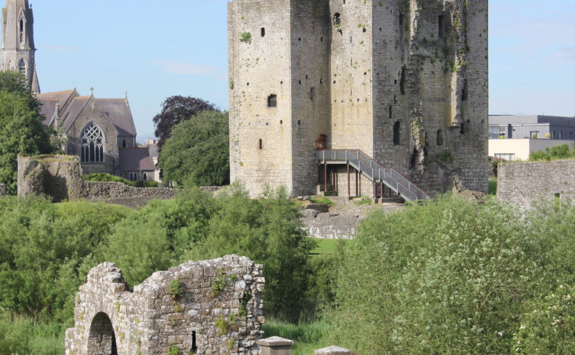
Trim Castle, in County Meath, Ireland, was built starting in 1187 by the De Lacy family as part of the Anglo-Norman conquest of Ireland. After a long history of conflict, disputed ownership, expansion, change, and decay, the castle was finally abandoned in the mid-sixteenth century when it was described as being full of cattle and dung. The medieval landscape around Trim is remarkably well preserved, including the walls of the town, a fourteenth-century bridge over the River Boyne, a variety of religious institutions, and the farmlands, called the Porchfields, which still have their ridge and furrow plough marks.
In 2016 and 2017, Michael “Bodhi” Rogers led a team of students to digitally record Trim Castle and the surrounding landscape. That scanning project was described in Archaeology Ireland (https://www.jstor.org/stable/pdf/26565802.pdf). The results of that project allowed further study and analysis of the landscape, and specifically the viewscape, of Trim Castle. In a three-way interdisciplinary project, Scott Stull (archaeology), Michael “Bodhi” Rogers (physics), and Michael Twomey (medieval literature) looked at Trim Castle and how the views from the castle were carefully constructed as part of the creation of medieval power and authority.
Trim Castle showing the Dublin Gate (foreground) and Keep (background), image credit Michael “Bodhi” Rogers
The starting point for this study, which is a chapter of the upcoming volume, Bailey, Kinsella, Thomas (eds) Architectural Representation in Medieval Textual and Material Culture (Arc Humanities Press, 2022), is the concept of the cultural landscape. The cultural landscape is how people shape a landscape and put meaning on it, to influence perception, behaviour, and patterns of social interaction. It can be practical, such as food production, or it can be tied to belief systems, such as religious sites, places associated with an ethnic or group identity, or associated with structures of power and authority. Castles, while often associated with military activity, embody most of these elements, and as part of the cultural landscape help create beliefs that support those practices and perceptions.
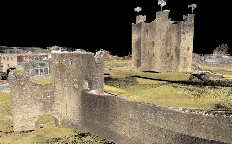
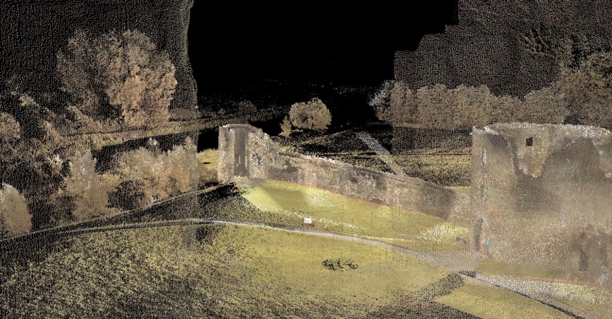
Viewscapes are a specific aspect of a cultural landscape, and in this case are the views from the castle. At Trim, the castle is placed to oversee the town, roads, bridge, farm fields, and religious institutions. There are a variety of ways to identify and record viewscapes, such as with mapping and GIS systems (for example: Lisa Karen McManama-Kearin, The Use of GIS in Determining the Role of Visibility in the Siting of Early Anglo-Norman Castles in Ireland, BAR British Series 575, Oxford: British Archaeological Reports, 2013). Our study, overseen by Bodhi Rogers, used ground-based lidar to make a 3D record of Trim Castle and its surroundings. The result of the recording is effectively a 3D photograph which you can examine from any angle or point in space. This allows us to see from windows which are inaccessible physically, or from spots which have been lost due to decay or collapse over time.
Digital record of Trim Castle showing the view from the Constable’s Tower toward the Dublin Gate and River Boyne, image credit Michael “Bodhi” Rogers.
While a useful modern tool, viewscapes were a fundamental part of the medieval understanding of castles. We see castles used as viewing platforms, as symbolic places of literal and figurative elevation, and as part of medieval romances where the view from the window represents both the desire and distance of a romantic attraction. In many cases, the lady views the desired knight from the castle window, and the knight is inspired by the glimpse of the lady in the window, affirming the ideals of courtly love. Religious allegories have the castle as a tower of morality, and the viewscape is often overlooking humanity in all its faults and mundanities. By looking at medieval literature, we can gain an understanding of the medieval mindset.
Combining the physical context of a castle with the medieval mindset allows us to gain a more complete understanding of medieval life. The nobility used castles as structures of power and created a cultural landscape which made that system of power seem normal and natural. Castles were a central part of everyday life in medieval Europe, and the lived experience of medieval people was shaped by the created landscapes in and around a castle. At Trim, the castle overlooked the social and economic centres of the community, from the Porchfields to the monasteries. The viewscapes from the castle were specifically created to reinforce the position of the De Lacy family and its successors over the lands and cultural landscape in Trim. Trim castle was the dominant element in both the physical and social landscape.
In its latest round of grants the Castle Studies Trust has awarded £34,000 to five projects including two projects outside the UK. As well as covering a wide geographic area the projects will also undertake a broad range of technics to boost our understanding of castles.
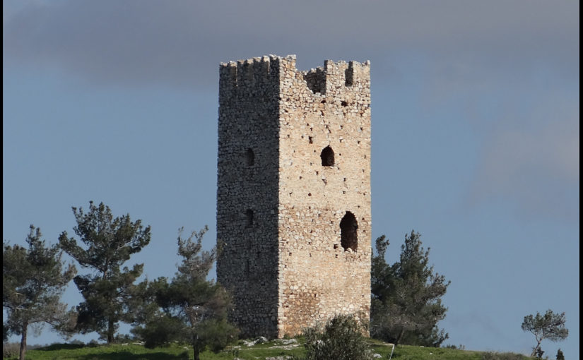
Dating medieval towers in the hinterland of Medieval Chalkida, Greece:
Mytikas South Tower copyright Andrew Blacker
Stand-alone medieval towers, often part of castles or larger fortifications, are common in Central Greece. Often thought to have been built by the Frankish nobility during their period of dominance between 1204-1470, there is minimal evidence to back this up. By taking wood and mortar samples, the project aims to answer that question.
The present project forms part of the five-year survey ‘Beyond Chalkida: Landscape and Socio-Economic Transformations of its Hinterland from Byzantine to Ottoman times’ (authorised in July 2021 by the Greek State)
Samples will be taken from six towers of wood used laterally within tower walls to increase their structural strength, and mortar from within the core of the walls (both therefore probably
contemporaneous to the original period of construction). Specialists will use dendrochronological and
Carbon 14 methodology for the wood (8 samples), and optical microscopy, Scanning Electron Microscopy (SEM), and X-ray fluorescence (XRF) and diffraction (XRD) Spectroscopy (mortar – 21 samples).
Work will start at the earliest in late 2022 and may not actually take place until next year due to the time it is likely to take to get official permission from the government.
Kilmacahill, Co. Westmeath
Geophysical survey of deserted medieval settlement close to Jamestown motte & bailey castle. The aim is to understand the morphology of settlement and its relationship with the castle and medieval monastery.
This survey will contribute to a larger project: the Human-Environmental Exchanges in the Landscapes of Medieval Ireland Project (HELM Project) which aims to use a combination of multispectral imaging, UAV drone survey along with geophysical survey to gain a much better understanding of the form of the deserted medieval village through non-invasive methods.
At time of writing it was unclear when the survey will take place.
Pontefract, West Yorkshire
Pontefract Castle: Service area between the kitchen and royal appartments copyright Angela Routledge, Wakefield Council
The project funded will be a geophysical survey of two parts of the castle, which during its history was the main royal castle in Northern England, not previously investigated. The survey will be of two areas of the castle using Magnetometry, Resistivity and Ground Penetrating Radar (GPR)
The focus is on parts of the castle not previously explored by excavations in the 1980s, especially around the northern ramparts. This area stretches from the Swillington Tower towards the Kings Tower, and includes several earthwork features which remain unidentified, or unconfirmed. Geophysical investigation is likely to reveal several interesting features including the link wall between the curtain wall and the Swillington Tower, which is unique in that it was built outside the main castle defences.
A second area that we have very little information on is part of the castle known as the “service buildings”. This area has never been excavated and we have very little knowledge regarding the layout or function of this part of the castle.
As yet it is unclear when the survey will be undertaken.
Raby, Co Durham:
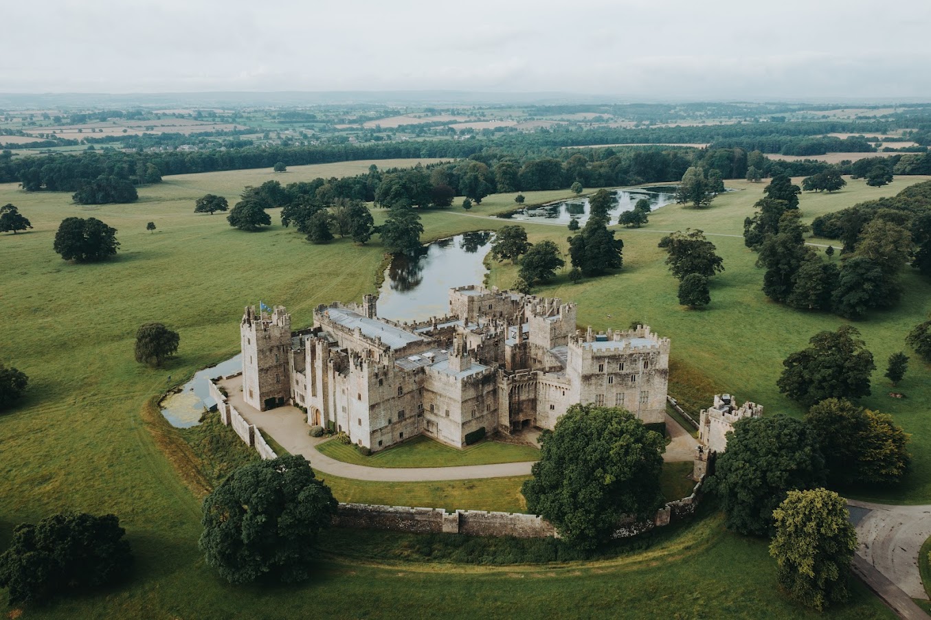
Aerial View of Raby Castle copyright Raby Castle
The Trust will be co-funding the project which aims to improve the understanding of the castle in the medieval period, especially around 1400 in the decades immediately after the licence to crenellate, with a buildings survey and development of a 3D model.
Once a stronghold of the Neville family, it moved into the ownership of the Vane family in 1626 and has been much altered and modernised, especially in the Victorian period, into a palatial family home. Large sections of the medieval castle survive intact, albeit intersected and extended with more recent architectural additions.
This project seeks to strip back the more recent layers, to make sense of the medieval castle. Our aim is to create a 3D visualisation of Raby Castle in around AD 1400, helping us to visualise and to understand (where possible) how it functioned before the later additions.
In addition to boosting our understanding of the castle, the plan is also to train up a team of volunteers in how to carry out a building survey.
The aim is to start the survey work in April.
Shrewsbury, Shropshire:
Shrewsbury Motte Top copyright Nigel Baker
This is the third project the Trust has funded on this important castle of the Welsh Marches and is an excavation of the motte top. The first two excavations in the inner bailey discovered that the original inner bailey was a lot smaller than it is today with little room for any substantial buildings, especially the royal hall.
This leaves only the motte and the aim is to understand the structural sequence and assess the character and the status of the buildings there: specifically to identify the royal hall known to be present during the Middle Ages.
The excavation is due to take place in the second half of July.