By Dig Director Jim Brightman of Solstice Archaeology
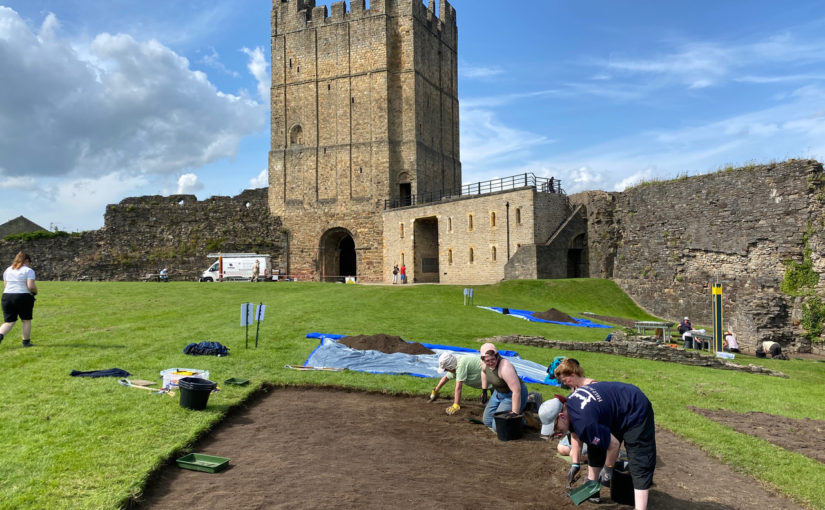
Although my plan with these posts was only to provide updates of juicy finds and exciting discoveries, I really wanted to just put pen to paper (so to speak) on the evening of the first day on site. It has been an absolute scorcher, which was not ideal for the back-breaking labour of de-turfing, but the project volunteers have been fantastic!
We removed all the turf in the two largest trenches we are planning on excavating: the east ‘entrance’ by Robin Hood Tower and the confluence of wall foundations near the Great Chamber revealed through geophysical survey.
First days on excavations are always a little unusual as everything gets set up, people find their feet and there’s often not a lot in the way of instant rewards in the topsoil. That said, the reception we have received from the English Heritage team and the crowds of visitors to the castle has been wonderful. Sitting with a family on the edge of Trench 1 going through the various topsoil finds and letting them hold these artefacts in their hands will never be less than a fantastic experience.
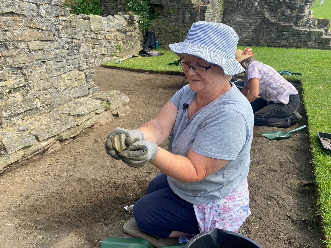
Irene with the piece of green glazed pottery she found
The first handful of finds have already started to paint a picture of the dual nature of Richmond Castle. The early 20th century was well represented with a large tent peg (let’s imagine it was from the very tent of Robert Baden-Powell!), some scattered pottery and a small bullet casing. The most exciting moment, however, was when Irene pulled out the first piece of medieval pottery: a fantastic fragment of green-glazed handle from a large jug! A few more pieces followed near the end of the day, and we are all eager to see what is revealed as we start to get deeper.
Jim Brightman of Solstice Archaeology, dig director of the Richmond Castle excavation, outlines what the next three weeks of excavations of Richmond Castle to mark the 950th anniversary of its founding. The excavation is being co-funded by the Castle Studies Trust along with Richmond and District Civic Society and Richmond District Council.
By way of an introduction to the Richmond 950 community excavation, I’m going to start with a bit of a personal reminiscence. I am a former pupil at Richmond School, and in the dim and distant past when I was in in Lower School (the old Grammar School building), the first topic covered in history lessons was the medieval period. I’d already been fascinated by the past through primary school, and I was ready for it to be my favourite class. I wasn’t disappointed. On a seasonably warm autumn afternoon, we all trooped up the hill for our first site visit: Richmond Castle.
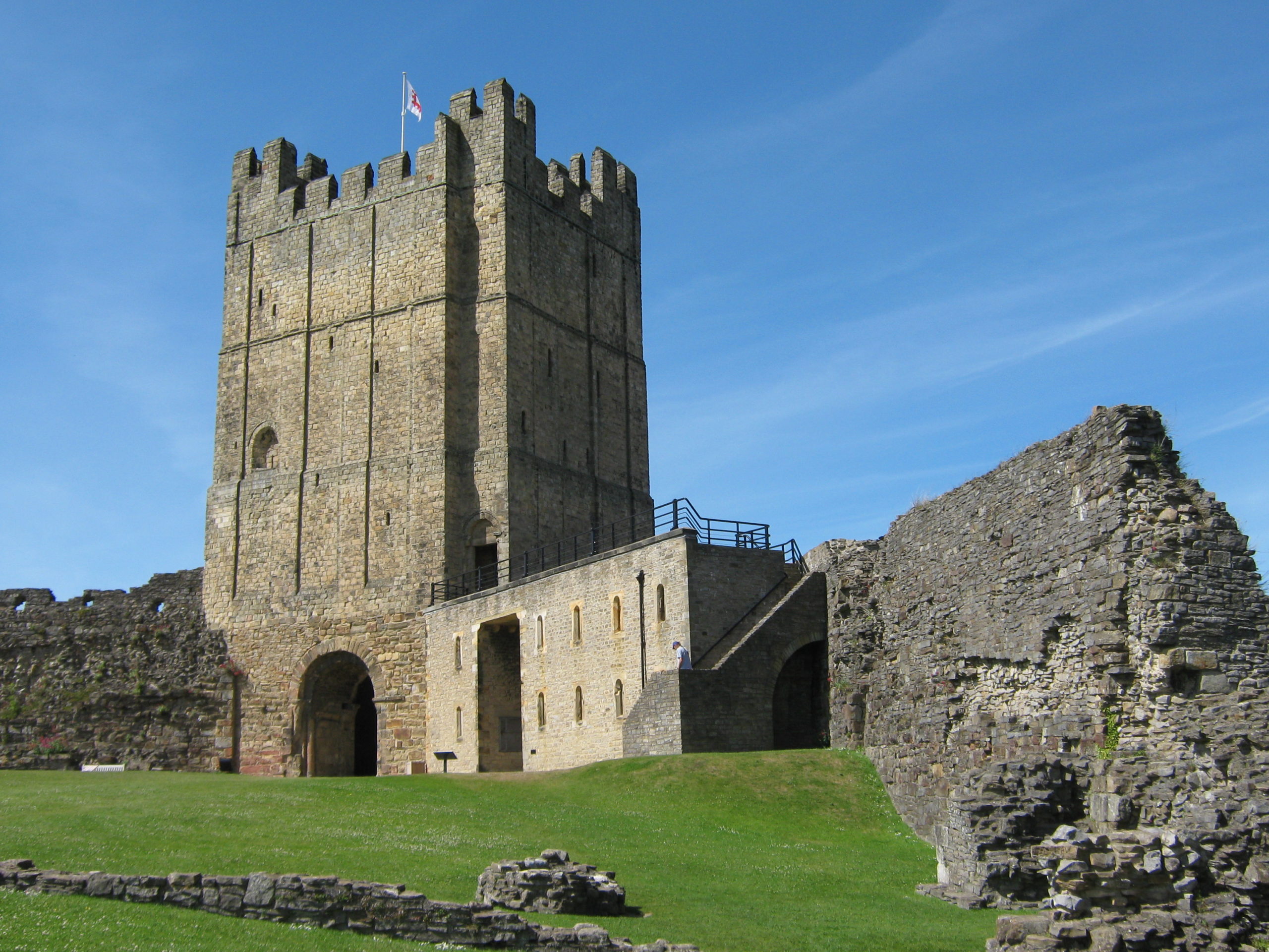
Many, many years later, having studied archaeology at university and spent my early career in and around the Peak District, I moved back home in 2012. The first time I walked back into town, I vividly remember thinking “was the Castle always that big?!”. Then as now, and as in the centuries preceding, the keep towers over the marketplace, easily the most prominent building in the town’s skyline. Indeed, I was so taken with this icon of my childhood love of history, that the outline of the Castle now features on my company’s stationery!
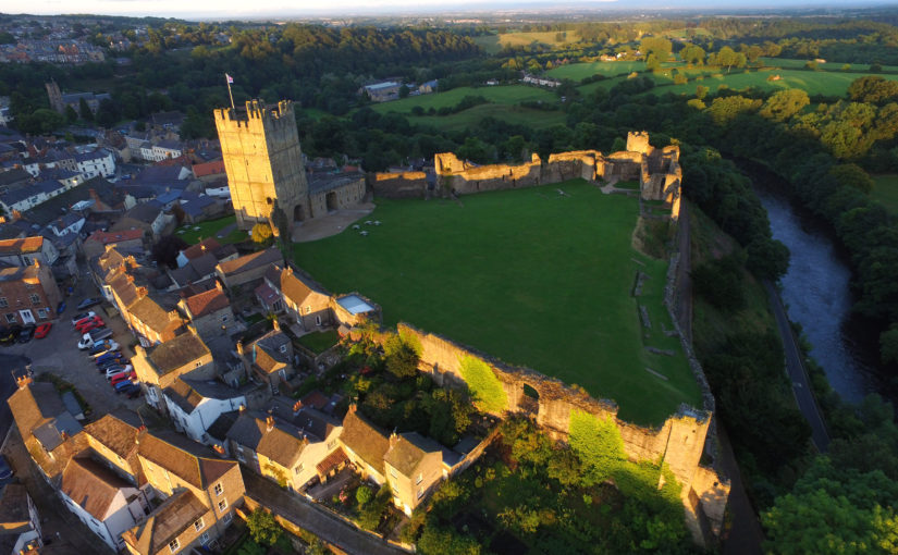
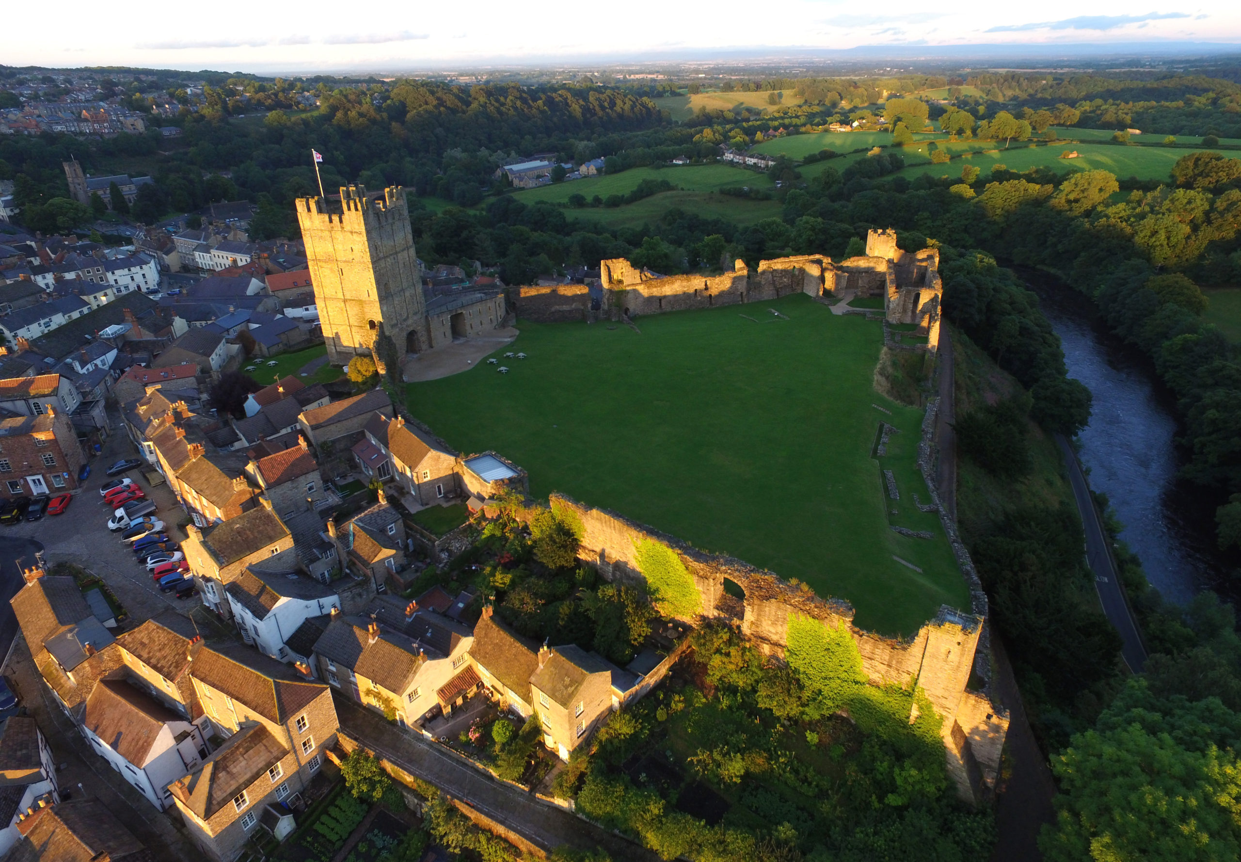
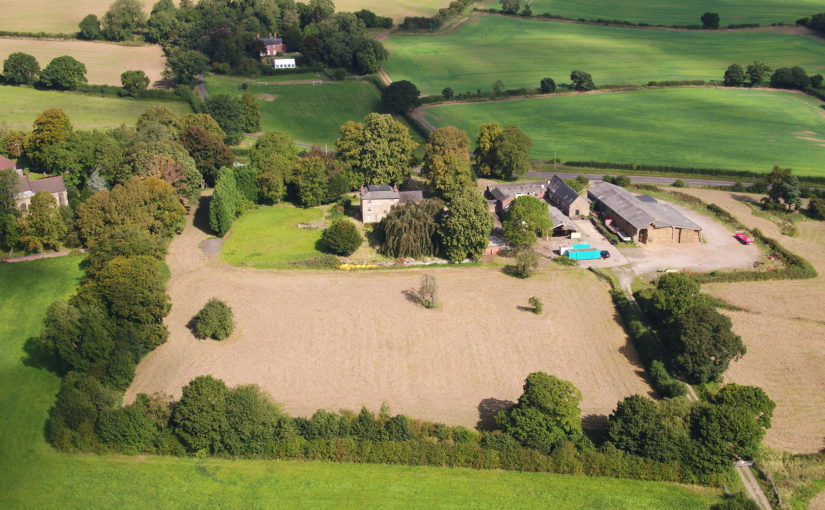
Richmond Castle’s Great from the Bailey near where some of the trenches will be placed. Picture courtesy of English Heritage.
With the 950th anniversary of the Castle’s original founding rapidly approaching, I was overjoyed at the opportunity to run a volunteer archaeology excavation as part of the wider celebrations being held in the town through the course of 2021. Having been fortunate enough to be involved in a lot of community archaeology projects through the course of my career, it felt like a real homecoming.
As we started developing the project, it became clear that there was a wealth of places within the Castle where targeted excavation had the potential to shed light on parts of its story that have remained hidden. Geophysical survey in recent years has revealed whole complexes of possible walls and structures beneath the grassy sward of the bailey, and Richmond 950 is the first time that they will see the light of day for many, many centuries.
Richmond Castle from the air. Most of the excavation will take place along the far wall where many remains have been located. Picture courtesy of English Heritage.
The volunteer archaeology project was made a reality by the kind support of several funders, all of whom believed in the vision of engaging local people directly with the tangible past in such a beautiful and historic setting. We are very grateful to the Castle Studies Trust, Richmond and District Civic Society and Richmondshire District Council for their huge generosity and support – I feel strongly we will repay your trust with a fantastic project!
As I write this on the eve of the project starting, we are almost fully booked in terms of volunteer places—a real testament to the interest in archaeology in and around Richmond. That said, if you are reading this and getting the itch to try your hand at archaeology, then there are still a few places available on our Eventbrite link; no experience is required and everything you need to unlock your inner Indiana Jones is provided! Even if you are just interested in finding out more, then the Castle is still open to visitors through the next three weeks while we are digging, and we would be delighted to talk you through the unfolding story of the archaeology.
Dr Sarah Jane Gibbon and Dan Lee (UHI Archaeology Institute / ORCA) project leads for the Castle Studies Trust funded project explain the reasons behind the excavations they are undertaking at The Wirk in the Orkneys and what they hope to achieve during their two week dig.
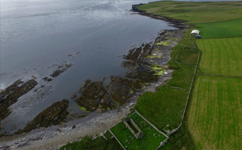
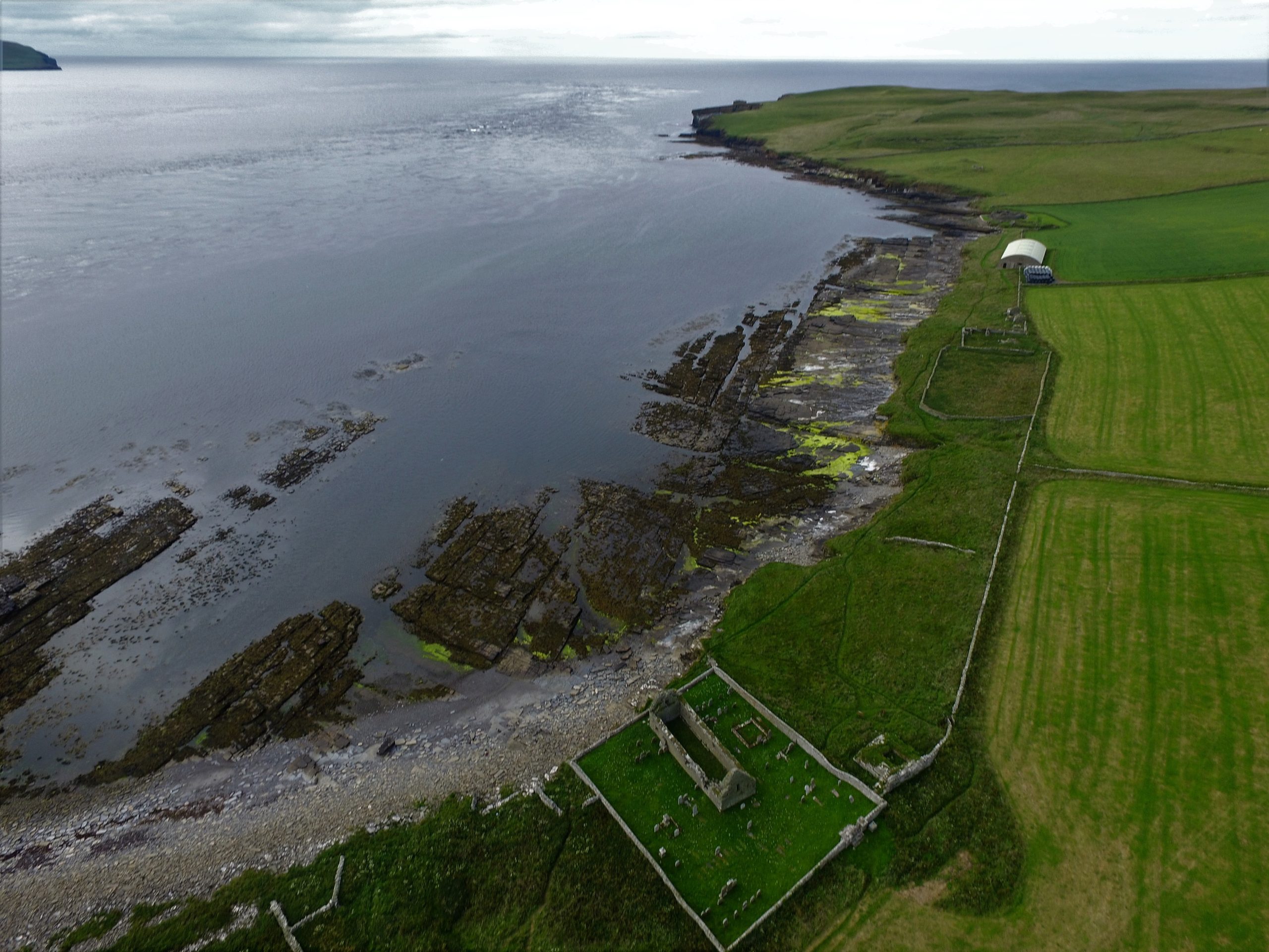
Located on the south-western coast of Rousay, The Wirk is located in one of the most archaeologically rich parts of Orkney. The Orkney Research Centre for Archaeology (ORCA) is undertaking geophysical survey, archaeological excavations and 3D modelling at this enigmatic castle site (pending approval from HES).
The Wirk, meaning stronghold in Old Norse, and with the alternative name Westness Castle, is a small stone tower located close to the coast. It has variously been interpreted as a 12th century Norse Castle, a detached fortified bell-tower, a 13th century defensive tower for an incomplete church, a hall-house garderobe tower and most recently a 16th century tower and attached range.
View of The Wirk, located on the righthand corner of St Mary’s Church yard in the foreground, looking northwest to Midhowe and the Atlantic Ocean (Image: Bobby Friel @TakeTheHighView).DCIM100MEDIADJI_0558.JPG
Minor clearance and excavation in the 1920s identified similarities in construction between The Wirk and the 12th century Cubbie Roo’s Castle, on the nearby island of Wyre, considered to be one of the earliest stone keeps in Scotland. The Wirk is located in Westness which has been a large estate since at least the 12th century when it was the home of the Norse chieftain Sigurd of Westness (Orkneyinga saga). It is adjacent to Rousay parish church, likely to date from the 12th century, with standing remains of 16th century date on earlier footings.
Recently, the 12th/13th century date attribution of The Wirk has been rejected in favour of a 16th century date. This new interpretation is based on the built remains and 16th century architectural fragments which were found in the 1920s. However, architectural fragments of 12th/13th century date were also present and nearby archaeology, particularly the discovery earlier this year of a Norse hall at Skaill by the UHI Archaeology Institute would suggest this was a high-status place in the saga period. This is not to dispute that The Wirk may also have been in use in the 16th century when the estate was owned by a prominent Orkney family. One of the objectives of this project is to excavate trial trenches over Clouston’s excavation and at the eastern end of the site to identify the earliest phases of the tower and adjacent building. Upper parts of the tower were substantially rebuilt in the 19th century and so excavation will allow us to record parts of the site that have not been knowingly rebuilt.
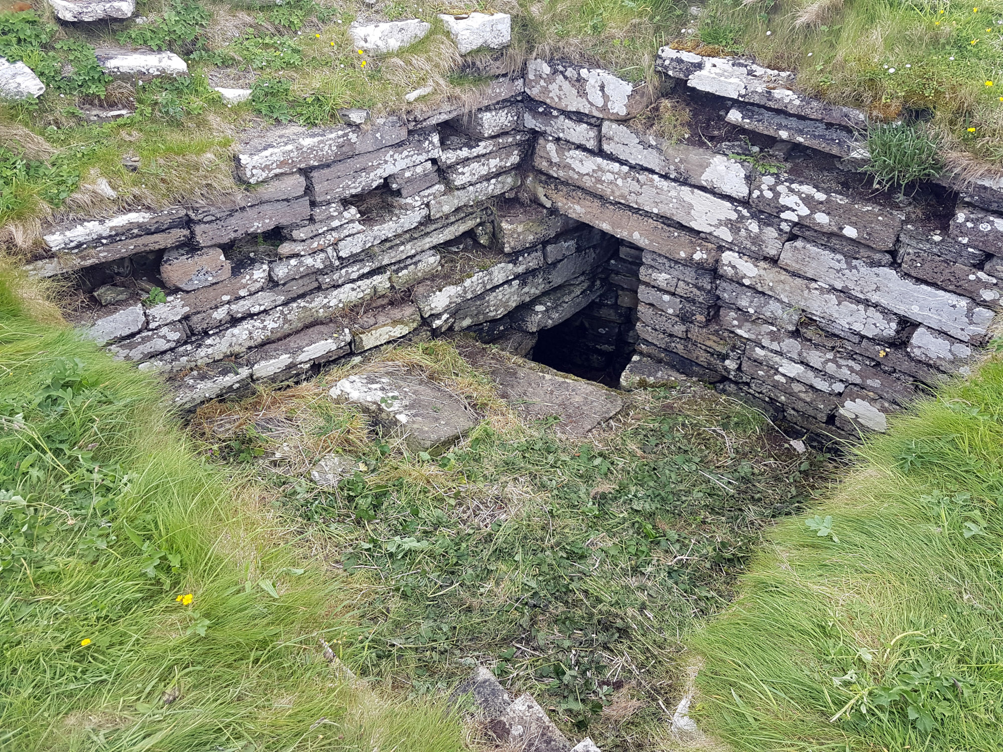
Inside The Wirk tower, looking southeast, showing the entrance to an underground well or passage (Image: Dan Lee)
Along with the excavations, targeted geophysical survey around The Wirk undertaken in September 2020 aims to better understand any relationships between the tower and the buildings/features which surround it. The results show that the walls planned by Clouston are accurate and that they likely survive just below the ground surface. 3D modelling of The Wirk and Cubbie Roo’s Castle will enhance our understanding of these comparable sites and allow the public to explore the remains online.
The start of the project was delayed in 2020 due to the Covid-19 pandemic, and we will be glad to finally get on site for the excavations in July.
Professor Matthew Johnson of Northwestern University takes a look the iconic Bodiam Castle.
Many readers of the Castle Studies Trust blog will be only too familiar with Bodiam Castle. It is the most-discussed late medieval castle in England, and probably in Europe. Over the last ten years I have worked with a team of researchers from Northwestern University and the University of Southampton, in partnership with the National Trust. We carried out a new survey of the building, a topographical and geophysical survey of the surrounding landscape, and a synthesis of the extensive ‘grey literature’ on the site. Our work was published in the 2017 volume Lived Experience in the Later Middle Ages; digital copies are freely available here. We deliberately avoided older debates, and instead stressed a landscape of work and the variety of lived experiences of different people as they worked and moved around the castle and local landscape.
In this short blog post, I want to highlight one point: Bodiam needs to be understood as a multi-period site and landscape. One of the mistakes of the old ‘defence vs status’ debates was to see Bodiam simply as a creation of the 1380s and of one man, Sir Edward Dallingridge. Our work suggests rather that the building and its surroundings form a distinctive place with its own cultural biography that should be understood over the very long term, from the Palaeolithic to the WWII pillbox. It is a place that has seen reworking and recasting by different social groups over the centuries and even over the millennia.
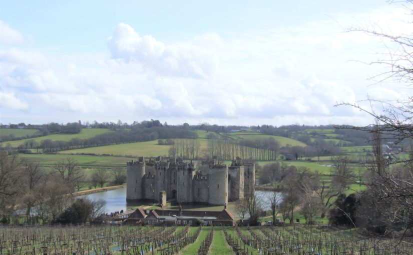
The castle viewed from the N, photo taken from the older manorial site, also known as the ‘Gun Garden’ or ‘viewing platform’. The floodplain of the Rother can be seen behind the castle, with the Weald rising up beyond and the linear village of Ewhurst Green strung out along the horizon.
The stone fabric of the castle does, indeed, date largely to the 1380s, and the use-life of the stone structure was relatively short; it was probably derelict and rarely used by the end of the 15th century. However, its story is not just that of one man. Bodiam was a manor of the Wardedieu family, which Edward inherited through his marriage to Elizabeth Wardedieu. Alice Beauchamp, a wealthy widow and subsequently warden of the infant king Henry VI, married John Dallingridge, son and heir of Edward; John died soon after his father, and Alice became chatelaine of the castle for 35 years until her death in 1443 (Johnson 2020, 321). Usually presented as the creation of a single powerful man, Bodiam then was one of the residences of a powerful woman for much of its active use. The elaborate stacked, double suite of ‘private’ chambers at the upper end of the hall needs to be understood in this gendered context.
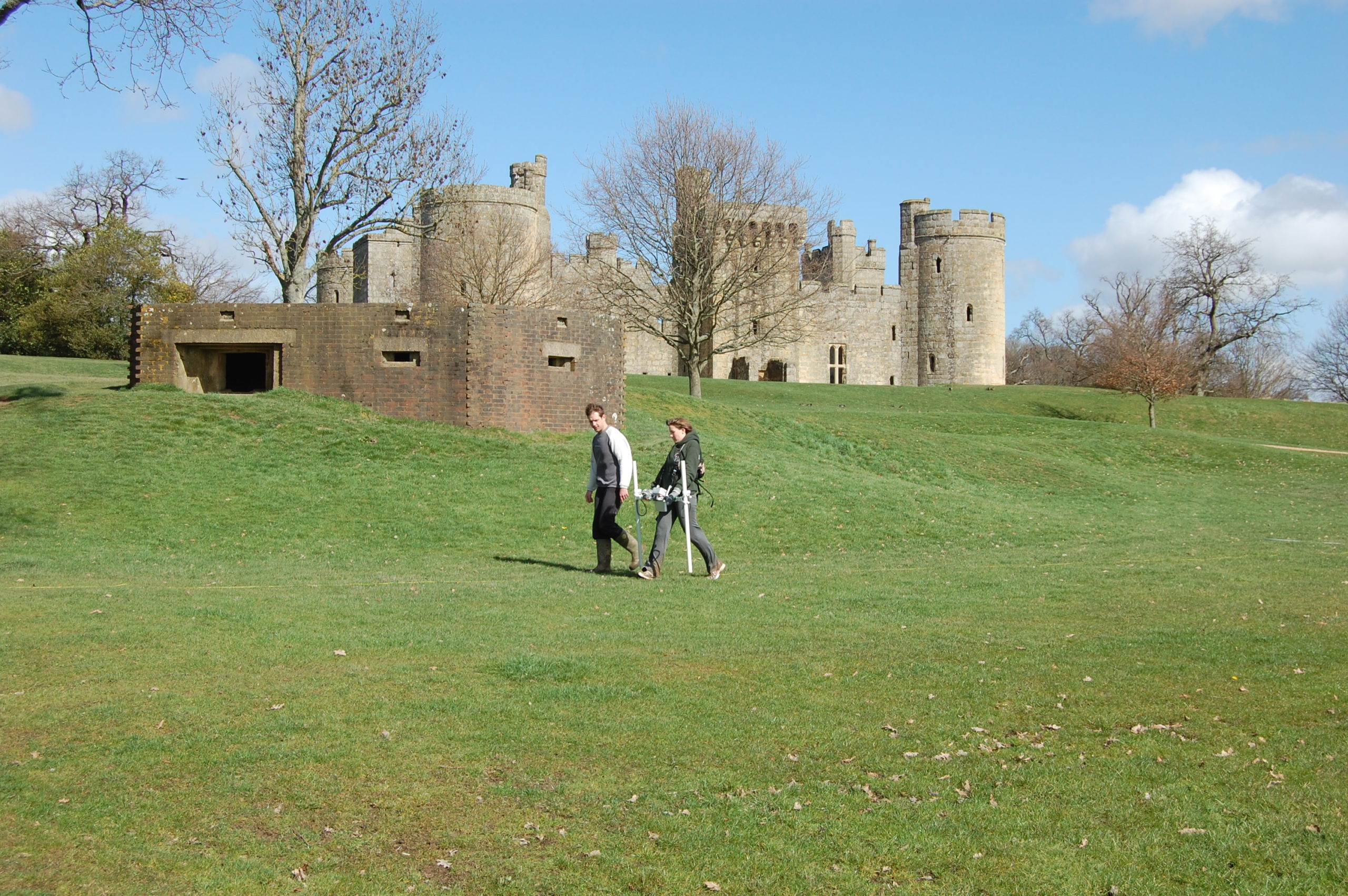
Much of the internal fabric, and most of the barbican, was ‘robbed’ of building stone in succeeding centuries; many visitors stopped to leave their mark in the form of graffiti. In the 1830s, ‘Mad Jack’ Fuller bought and restored the site and landscape. Fuller’s wealth came in part from his ownership of enslaved people on plantations in Jamaica, as the recent National Trust report describes. In the 1920s, the castle was restored again by ex-Viceroy of India Lord Curzon; Curzon of course was also responsible for the restoration of the Taj Mahal. His activities at Bodiam included the failed construction of a cricket pitch (the selected site, which he named ‘the tiltyard’ but which was in fact the basin of the old millpond, was not an ideal choice). The later cultural biography of Bodiam, then, is part of a story of colonialism and postcolonialism.
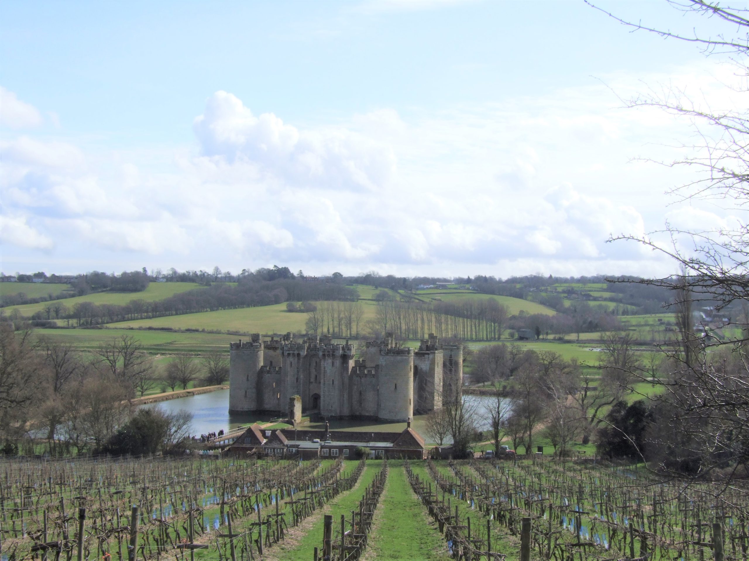
University of Southampton students surveying what Curzon termed the ‘tiltyard’, in reality the former millpond, in April 2010. The castle and WWII pillbox are in the background.
However, it is the prehistory of the site – its enduring importance as a critical place in the landscape – before the 1380s that most fascinates me. The castle itself was ‘fitted in’ to an earlier framework of manorial site, village tenements, river crossing and wharf. The whole assemblage sits at the junction of the Weald and the Rother Valley. The Kent and Sussex Weald, with its rolling hills, heavy clay soil and extensive woodland, contrasts with the floodplains below, running out to Romney Marsh. Climatic variation and the troubled history of land reclamation has meant that at different times, the valley has been shallow estuary, marshland, or fertile fields (it will return to shallow estuary in 100 years if climate change continues). Bodiam sits at the lowest crossing point on the river Rother, on a N/S Roman road, at a point which was a ford but which had a bridge from the 12th century onwards.
When I lecture on Bodiam, I like to suggest to audiences primed for discussion of knights, gunports and the Hundred Years War that the critical moment in the biography of the Bodiam landscape is not the 1380s, but rather the Early Bronze Age, when the complex interaction between human and environment meant that peat accumulation in the valley stopped and was replaced by alluvium. And I like to go back still further, to a time in the deep past when the valley was some metres deeper and the surrounding hills some metres higher, giving a less comfortable and more rugged feel to the landscape.
Jacquetta Hawkes (1967) famously said that ‘every generation gets the Stonehenge it deserves – or desires’; the same, arguably, is true of Bodiam. The Bodiam for our generation is, in part, a place of cultural biography and long-term climatic change, where humans have worked with and through the landscape to create, maintain and transform a place that has had an enduring importance over the millennia.
Hawkes, J., 1967. God in the machine. Antiquity 41, 174-80.
Johnson, M.H. (ed.) 2017. Lived Experience in the Later Middle Ages: Studies of Bodiam and Other High Status Sites in South East England. St Andrews, Highfield Press.
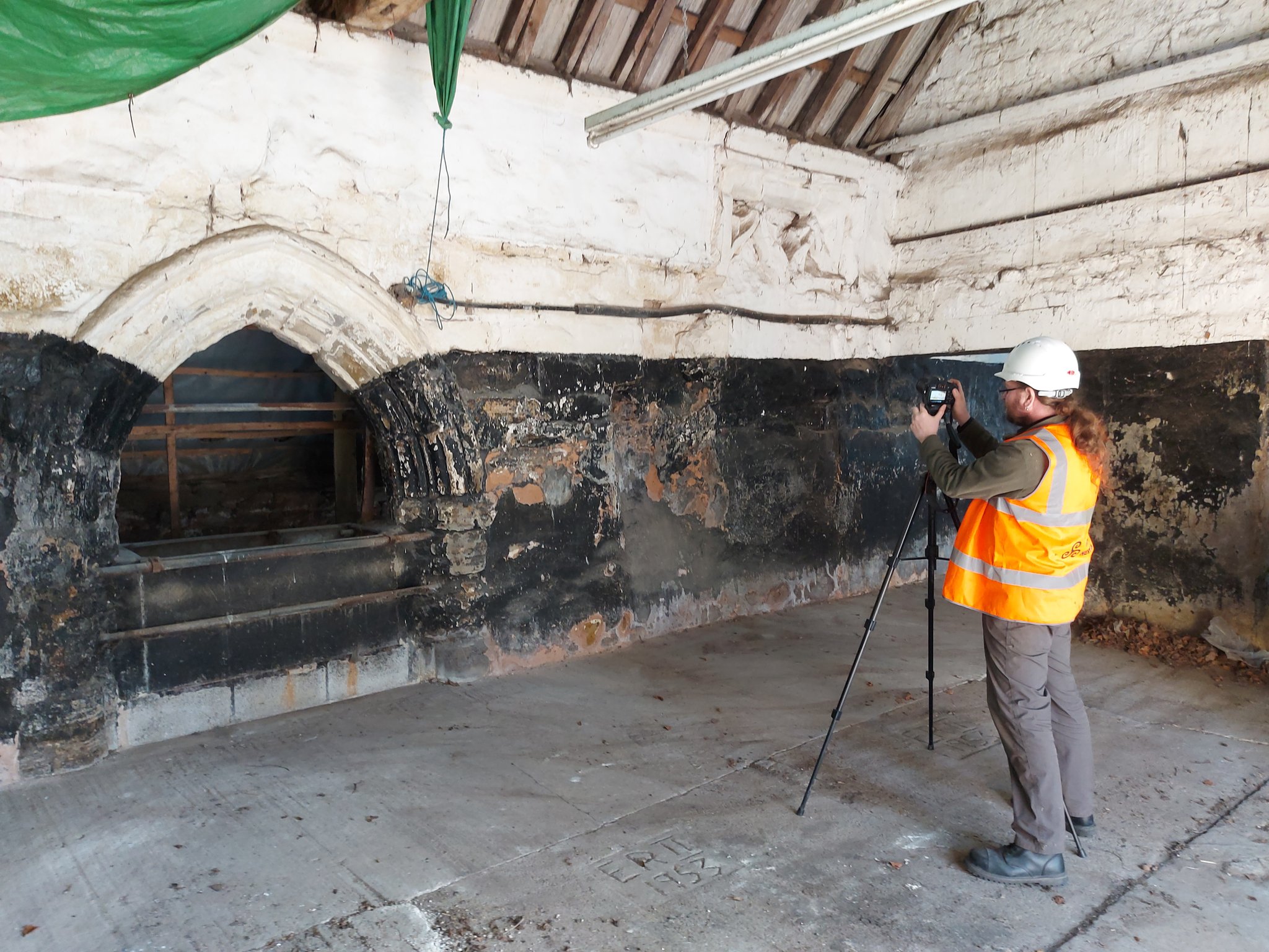
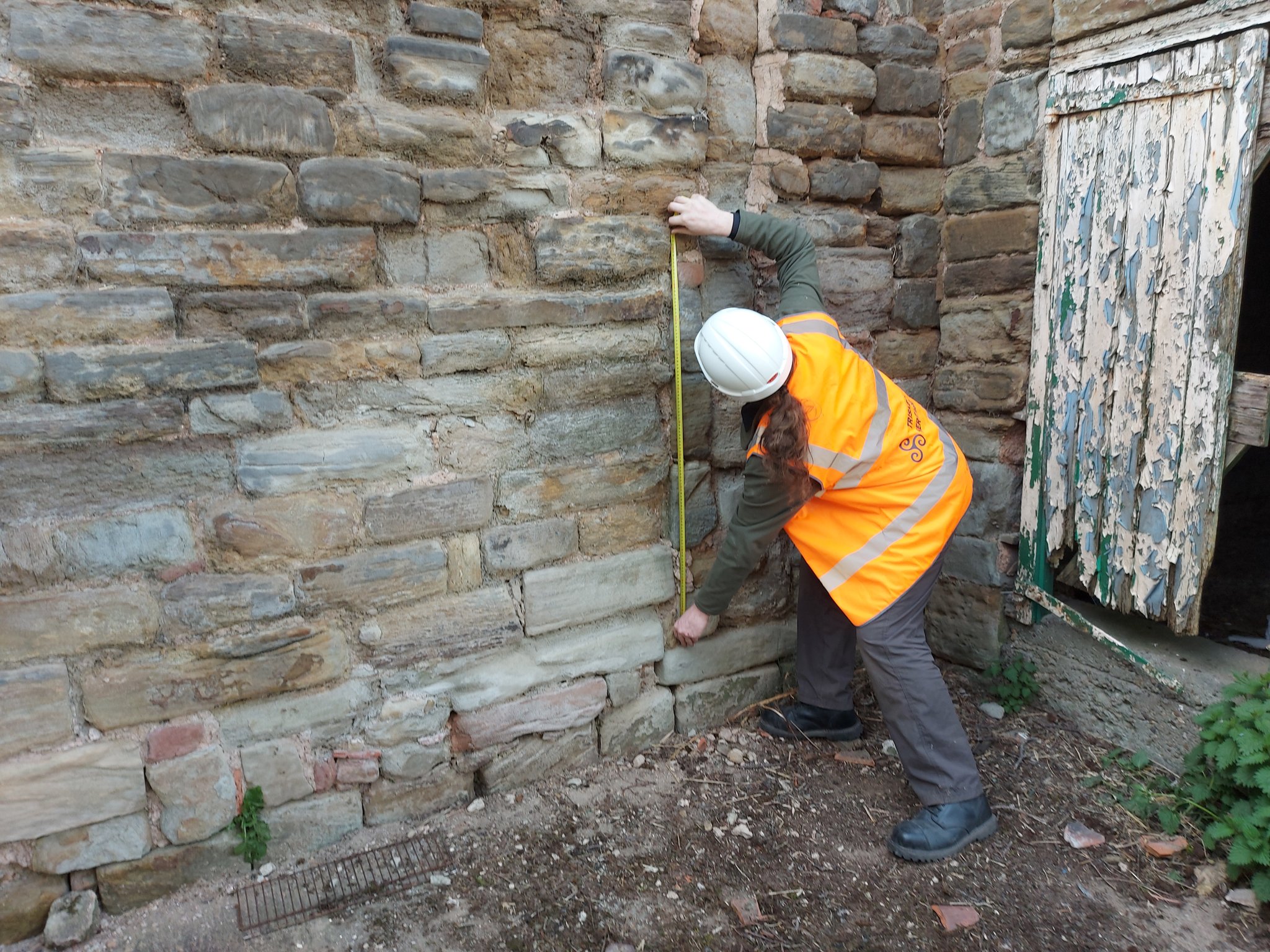
Back in January 2021 Triskele Heritage were successful in a funding bid to the Castle Studies Trust for carrying out a research project atGreasley Castle in Nottinghamshire. Here James Wright of Triskele Heritage explains what they hope to achieve with this project.
The work will focus on the production of an interpretative phased floor plan. The castle, built in the 1340s, has an obscure history and the understanding of its architectural phasing is at best very cloudy. The site is now a working farm and a number of post-mediaeval structures have been conglomerated around the remains of what is suspected to be a fourteenth century courtyard house with projecting corner towers.
The survey will act as baseline research data for a site which has not previously received serious fieldwork or publication. It will also provide a basis for further research and future conservation needs.
Work on the project will start in April 2021 and will be carried out by James Wright FSA alongside Dr Matt Beresford. We are supported in this endeavour by the landowners and Sarah Seaton of the Greasley Castle and Manor Farm History Project.
Greasley survey in action – photogrammetry
Project Background
Greasley Castle was developed for Nicholas, 3rd Baron Cantelupe (c 1301-55) after being granted a licence to crenellate by Edward III in 1340 (Davis 2006-07, 239). He was a significant figure who fought for the king in France and Scotland, served in parliament, founded Beauvale Priory and established a chantry at Lincoln Cathedral (Green 1934). Later owners of the site included John Lord Zouche – one of the few aristocrats proven to have fought for Richard III at Bosworth (Skidmore 2013, 330). After Zouche’s attainder, the castle was given to Sir John Savage in recognition for his military support of Henry VII in 1485 and remained in the family after his death at the siege of Boulogne (Green 1934).
The site is now a working farm and comprises two grade II listed buildings (NHL 1247955 and 1248033) overlying a scheduled ancient monument (NHL 1020943). The buildings sit along the northern perimeter of a 5.18 hectare earthwork enclosure and comprise a multi-phased U-shaped group of structures with an adjacent farmhouse to the north-west. The layout of the site is not well understood, but very limited prior research indicates the potential for a courtyard house with projecting corner towers.
The most substantive work on site took place in 1933 and comprised just two days of rather inadequate and poorly reported archaeological evaluation (Green 1934, 34-53). During the mid-2000s the wider landscape of the site was considered by the East Midlands Earthwork Project (Speight 2006). Greasley is routinely mentioned in surveys of castles stretching as far back as the antiquarian Throsby (1797, 239-42) and the early castle scholar Mackenzie (1896, 448-49). Although these initial commentators were of the opinion that little or nothing remained of the mediaeval castle, twentieth century authors, including Pevsner (1951, 76), his later editors (Pevsner & Williamson 1979, 135), Sarah Speight (1995, 70-71) and Oliver Creighton (1998, 479), noted in situ structures. In the twenty-first century a number of writers have pointed towards the tremendous archaeological potential of the surviving mediaeval architectural features (Emery 2000, 327; Salter 2002, 85; Wright 2008, 49-50, 65; Osbourne, 2014, 39).
Greasley survey in action: measuring
Crucially, the potential of the site has never been realised. Green (1934) noted that ‘it is not possible to be definite’ about the ground plan of the castle; a point later confirmed by Creighton (1998, 479): ‘the deficiency of the field evidence renders the exact nature and extent… obscure.’ The confusion surrounding the floor plan of the castle has been created by an overall lack of fieldwork and publication on the site. The paucity of research has led to a number of conflicting statements regarding the buildings archaeology. For example, the National Heritage List notes that the farmhouse was built c 1800 and has later nineteenth century elements (NHL 1247955); however, the most recent Pevsner edition notes that it is a seventeenth and eighteenth century building ‘with earlier origins’ (Hartwell, Pevsner & Williamson 2020, 240).
The proposed project to accurately map, assess and date the overall floor plan of the structures at Greasley Castle is long overdue and such building recording of manorial centres is specifically called for by the East Midlands research agenda (Knight, Vyner & Allen 2012, 94).
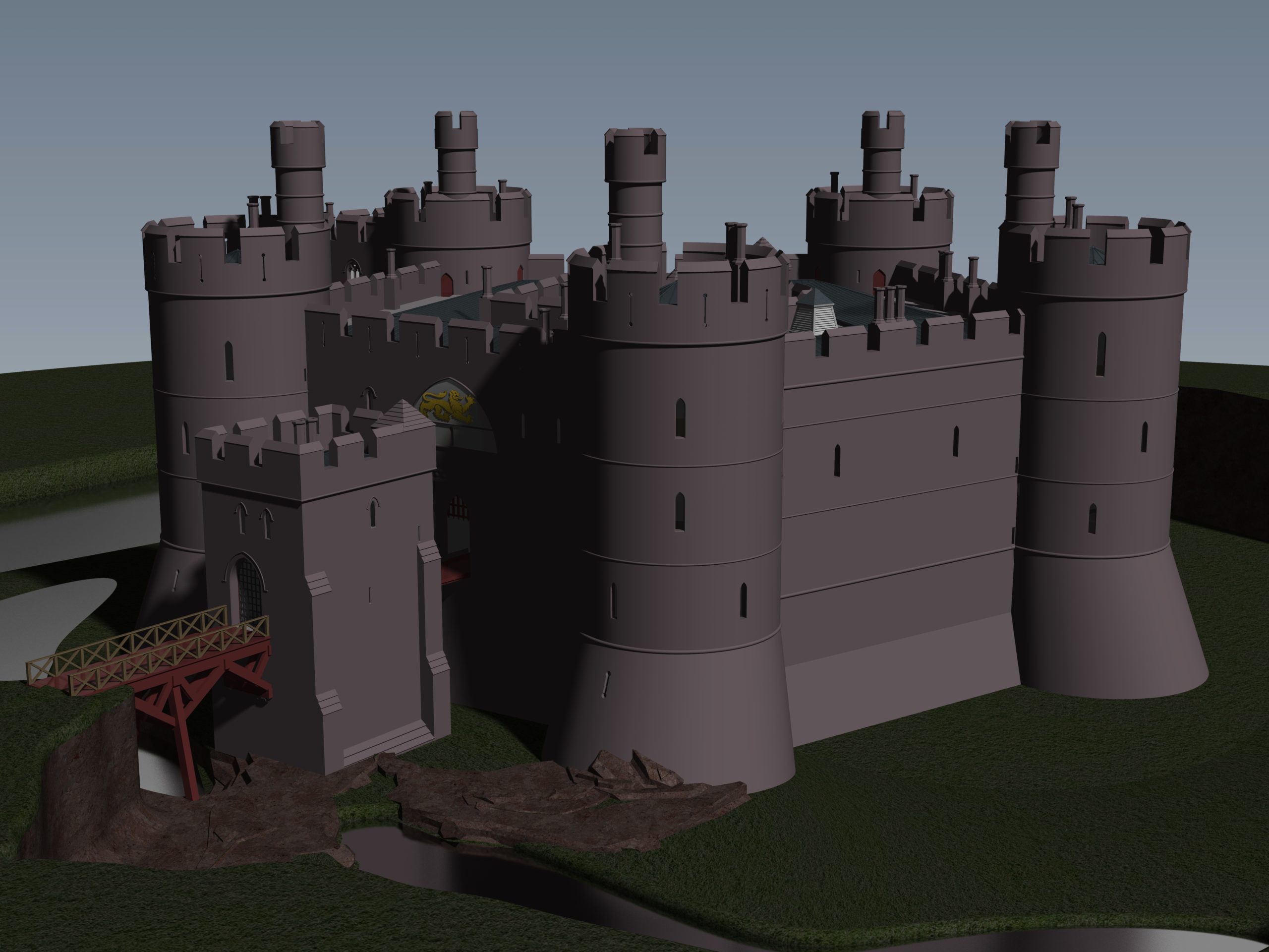
Little physically now remains of Holt Castle, however, one of the first projects the Castle Studies Trust was for leading buildings reconstruction artist Chris Jones-Jenkins and the late and much missed Dr Rick Turner to digitally reconstruct the castle using a mixture of historical sources and recent archaeological excavations to bring the castle back to life with a series of images and a video fly through. Here, in a piece first published in History Extra in 2015 explains how it was done.
To secure his conquest of north-east Wales, Edward I created five new Marcher lordships in 1282, and gave them as reward to his political allies and close friends in recognition of their loyal service. The lordship of Bromfield and Yale was granted to John de Warenne, sixth earl of Surrey (1231-1304). It is not known when he started building Castrum Leonis or ‘Chastellion’ as Holt Castle was known in the Middle Ages. The castle is first referred to in 1311 some years after it was probably completed. Warenne’s master mason chose an open and relatively flat site above the west bank of the River Dee, close to one of the ferry crossings into Cheshire. This allowed him to create a symmetrical pentagonal castle with a tall round tower at each corner, and the main rooms ranged around an inner courtyard. There were up to three storeys raised above the original ground level, with the moat and up to additional three basement levels cut down into the sandstone bedrock. It was a revolutionary design and was one of a group of similar architectural experiments being undertaken by the other new Marcher Lords at castles such as Denbigh, Ruthin and Chirk. At all these sites geometrical complexity, architectural grandeur and the provision of well-appointed accommodation seemed to be more important than their defensive capabilities.
Holt Castle as it was in its pomp courtesy of Chris Jones Jenkins
The sixth earl was succeeded by his grandson John, the seventh earl of Surrey (1286-1347). Described by Alison Weir as ‘a nasty, brutal man with scarcely one redeemable quality’, he was involved with the political upheavals of Edward II’s reign, including the loss of Holt Castle for a time to Thomas, earl of Lancaster. This John died without a legitimate heir, and Edward III intervened to settle his estates upon Richard FitzAlan, third earl of Arundel (c.1313-1376). His son, Richard the fourth earl (1346-1397) was one of the ‘Lords Appellant’, who had curbed Richard II’s powers and had the king’s closest allies executed or exiled during the ‘Merciless Parliament’ of 1388. It took nine years before the king was able to wreak his revenge on these powerful men. Arundel was brought to trial for treason at Westminster on 21 September 1397, and was convicted and beheaded on the same day. Richard II seized his estates and incorporated Bromfield and Yale into his new principality of Cheshire, with Holt Castle as its main stronghold. Building work was commissioned in 1398, which saw the Chapel Tower extended and included a water-gate, called ‘Pottrell’s Pit’ in later documents, linked to the river. Over the next year more than £40,000 in coin, jewellery, gold and silver plate was transferred from the royal treasury in London to Holt for safe keeping. When Henry Bolingbroke – later Henry IV – returned to England in 1399, he shadowed Richard II up the Welsh Marches and was quick to recapture Holt Castle. Despite being defended by 100 men-at-arms and being well provisioned, Henry’s men, including the French chronicler Jean Creton, were able to enter through the new water-gate and ascend ‘on foot, step by step’, to take the castle unopposed and so recover this vast proportion of the king’s disposable wealth.
Over the next 139 years, three more owners or stewards of the lordship of Bromfield and Yale were to be executed for treason. The first was Henry Stafford, second duke of Buckingham (1455-83). A year after his death, Sir William Stanley (c.1435-1495) acquired the lordship from Richard III. Despite his role at the Battle of Bosworth which brought his relative Henry VII to the throne, he was implicated in the Perkin Warbeck affair and was executed in 1495 after which Holt Castle reverted to the Crown. The last of this group was William Brereton (c.1487×90-1536) who was appointed steward of the castle where he held ‘great porte and solemnities’, before he was convicted of adultery with Anne Boleyn and beheaded.
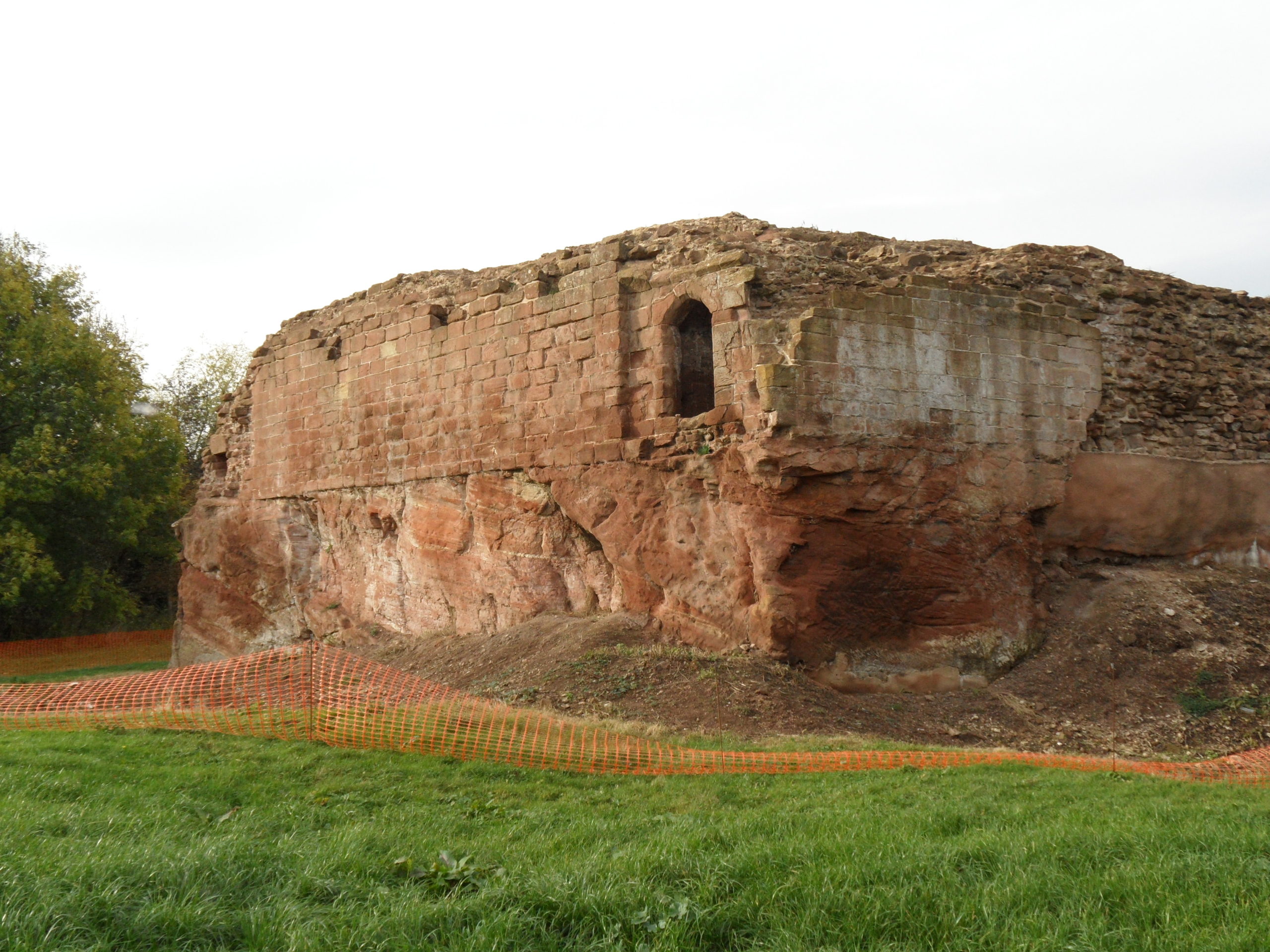
Holt Castle remained the property of the Crown and was to form part of the estates of the Princes of Wales. It was held for the king during the Civil War and in the 1670s, the buildings were sold off to Sir Thomas Grosvenor, who systematically dismantled nearly all the fabric and transported it to help in the building of his Eaton Hall, a few miles south of Chester. This has left us with the stump of rock and walling which survives today.
Reconstructing the Castle:
Two attempts have been made to understand the original the former appearance of Holt Castle: by Alfred Palmer in 1907 and Lawrence Butler in 1987. They had access to plans and views of the castle drawn in 1562 and 1620. The problem they faced was that these two sets of drawings are contradictory and they were hard to relate to what survived. Since 1987, new evidence has been made available:
Documentary evidence for Richard II’s building work.
The publication of a transcript of the Holt Castle inventory taken after Sir William Stanley’s arrest in 1495.
The discovery of a new early-seventeenth century plan of the castle in the National Library of Wales.
A programme of masonry consolidation, archaeological excavation and survey led by Steve Grenter, Wrexham County Borough Council, in partnership with the Holt Local History Society.
This new work prompted me to undertake another attempt to reconstruct Holt Castle. With the help of a grant from the Castle Studies Trust, I was able to commission the well-known castle reconstruction artist, Chris Jones-Jenkins, to develop a 3D digital model which was flexible enough to capture and assimilate the new data and modify the structure as new insights were gained.
The challenge has been to weigh each source of evidence and identify which strands should have precedence when contradictions emerge. A hierarchy was developed:
The visible masonry of the castle and the modern topographical survey of the site provided the primary terrain model on which the remainder of the castle was constructed.
The archaeological evidence for the rock-cut footings, the bases of three of the towers and the line of the channel leading into the water-gate provided other fixed points in the model.
By considering the content and the potential reasons for the drawing of the three, early-modern ground plans and the two associated views, that of 1562 was assessed to be the most reliable for the details that it showed, the early seventeenth century plan for its dimensions, and those by John Norden of 1620 to be the most inaccurate, despite them being the ones most frequently published.
The list of rooms and the route followed by the appraisers of the 1495 inventory provides the most comprehensive source for the internal layout of the castle. However, it became clear that those rooms without contents, such as the triangular ante-rooms to the towers and the latrines, were not listed.
None of the views of the castle were architecturally detailed, and none showed all of the exterior or much of the inner courtyard. This information had to be derived from surviving details from other Edwardian castles in North Wales or from work undertaken in Richard II’s reign, when considering the projection from the Chapel Tower.
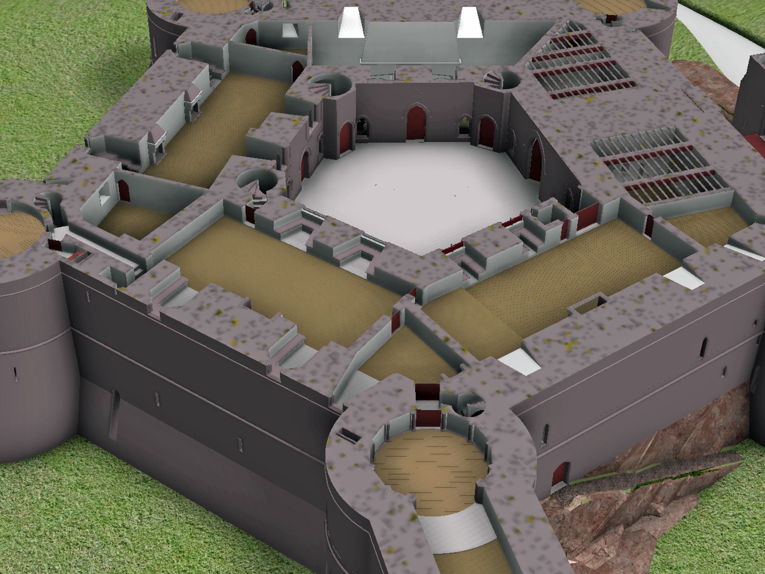
Holt First floor floor plan with with watergate to the fore and great hall and stable section to the right, copyright Chris Jones-Jenkins
The development of the model became an iterative process between the historian and the artist. Different combinations of layout and floor heights were tried, building on the fixed points surviving at basement level and rising up in an effort to accommodate all the rooms. Suites of accommodation began to emerge. Sir William Stanley’s great chamber led off the high end of the hall and controlled access in one direction to his counting house and the chapel, and in the other to the Treasure House and the High Wardrobe, where all the valuables were kept. Across the courtyard his wife, Elizabeth, had her own great and bed chamber, linked to the nursery. Above her accommodation was a chamber for her gentle women, well away from the yeomen’s dormitory under the lord’s great chamber. One range was dominated by the kitchen, rising the full height of the castle, connected at basement level to a larder, pastry house, well house and a wine cellar on one side and offices for the cook and butler on the other. As was normal the constable had a suite over the inner gate, but unusually a stable for 20 horses was created in a basement below the hall with access for the animals across the moat and up a ramp into the castle.
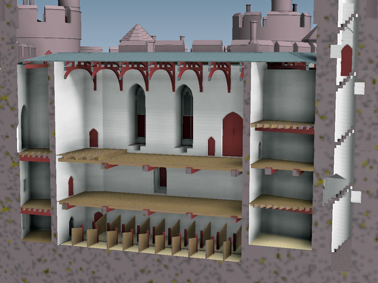
Holt Great Hall and Stables copyright Chris Jones-Jenkins
Working on this reconstruction, our admiration only grew for the original designer. He created a symmetrical plan and external appearance but produced complex internal arrangements to meet his patron’s needs. Holt is as much a chivalric ideal as a practical castle. An animation of the reconstruction of Holt Castle has been produced by Mint Motion of Cardiff and can be viewed here:
Dr Lorna-Jane Richardson, University of East Anglia/Bungay Museum, looks at the 1930s excavations of Bungay carried out by Hugh Braun and also the possibility of future work at the site.
Bungay is a small market town on the border of Norfolk and Suffolk, and sits on a meander in the River Waveney at the very edge of the Norfolk Broads National Park. The town is in a good defensive position, sat on a sand and gravel river terrace, some 10 metres above OD, with wide views across the valley and surrounded by marshland. This ‘natural fortress’ (Braun 1934) had seen earlier, perhaps early Medieval, defensive structures built, suggestive of a burh. This site was chosen for the construction of a castle firstly by one of William the Conqueror’s stewards, William de Noyers, who constructed a motte and bailey structure. The castle was bestowed on Roger Bigod, a Norman knight who was awarded estates in East Anglia and given Bungay in 1103 by King Henry I. Roger’s son, Hugh, known as Bigod the Restless, was made Earl of Norfolk in 1154, and he ordered the construction of the stone keep. The Bigods were the most powerful family in East Anglia for much of the 12th and 13th centuries. After nearly two centuries in the hands of the Bigod family, who also owned Framlingham Castle further south in Suffolk, Bungay Castle reverted to the Crown and fell into disuse. In 1312, Edward II gave the Castle to his brother, Thomas Plantagenet, and it eventually passed to the Dukes of Norfolk in 1483. However, it was recorded as being ‘ruinous’ by 1362, and over the subsequent centuries, the site was used as a source for building materials, the gatehouse was converted into a residence for an eighteenth-century novelist, and the keep was also used as a beer garden by the King’s Head Inn at least until the early 1930s.
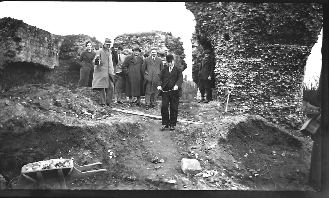
Dr Leonard Cane directing excavations at Bungay Castle in 1934
A group of Bungay dignitaries, led by the Town Reeve and local doctor Leonard Cane, leased the site from the Duke of Norfolk, and on 19th November 1934, the excavation of the site commenced. This excavation took place under the leadership of Dr Cane and Hugh Braun, an architect from London who had worked in Iraq with the Chicago University Expedition at the site of Nineveh. The excavation provided work for unemployed war veterans and interestingly, engaged the services of a local water diviner, one Mr John Davey who can be seen in Fig 2, to locate water and gold during the excavations. Further research is underway in an attempt to discover more about these veterans, and the role played by Mr Davey and his water-magic.
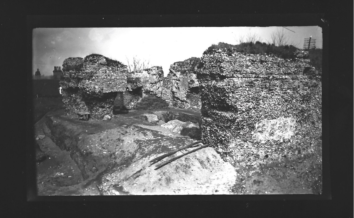
The excavations initially concentrated on the area between the keep ruins and the gatehouse, and around the keep itself, revealing buried walls which “would show the castle rising some twenty feet higher than before the excavation commenced” (Braun 1991, 23). The drawbridge pit was excavated, and the west wall of the keep was exposed, but other areas of the gatehouse and keep were left intact, after the excavation ran out of funds. Some of these areas were, according to Braun’s report, tidied and returfed ready for further exploration at a later date. These areas remain untouched, and no further excavations in the area of the gatehouse or keep have taken place since 1934. The excavations were subsequently published in the Proceedings of the Suffolk Institute of Archaeology and History in 1934, 1935 and 1936. There have been no further major archaeological excavations, although some unpublished monitoring work took place in 2001, 2006 and 2008 according to the HER, and geophysical work took place at the Castle in 1990 (Gaffney & Gater) and 2017 (Schofield). In 2017, what is now Cotswold Archaeology Suffolk undertook a detailed geophysical survey of the area of the inner bailey, which demonstrated very high potential for archaeological material and structural remains. These include evidence for buildings, a potential well, and a variety of pits some of which feature ferrous debris. Bungay Castle holds much potential for further archaeological work.
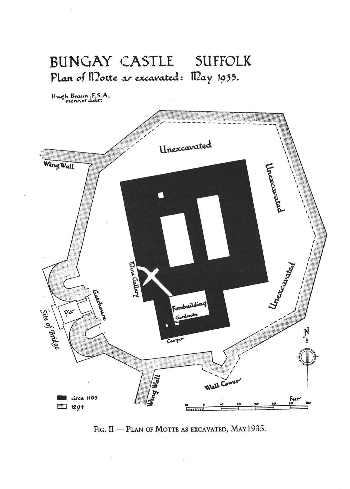
Map of the Castle Motte (Braun)
These photographs are from the Braun/ Cane excavations at Bungay Castle and are dated to 1935. They are part of the Bungay Museum collection, and there are around 40 images which feature the excavations, the people involved, and a variety local dignitaries and visitors to the site. In January 2021, I became curator of Bungay Museum, which was originally established in 1968 by Dr Leonard Cane’s son, Dr Hugh Cane. As part of this role, I plan to undertake further research into the contents of the museum collection, local contemporary news articles about the excavations, as well as Ministry of Works documents held at Kew, in order to develop new displays about the site and Bungay’s very own version of ‘The Dig’. Basil Brown himself would have certainly visited the excavations, as he lists the site in his notebooks, and he lived relatively locally. I hope my research will reveal more information about the names and lives of the veterans who dug the site, how the excavation was managed and run, more about the archaeological finds, and the mysterious role of water divination in the process. There are many interesting stories waiting to be told about the original excavations at Bungay Castle, and many more are waiting in the wealth of archaeology that remains in the ground.
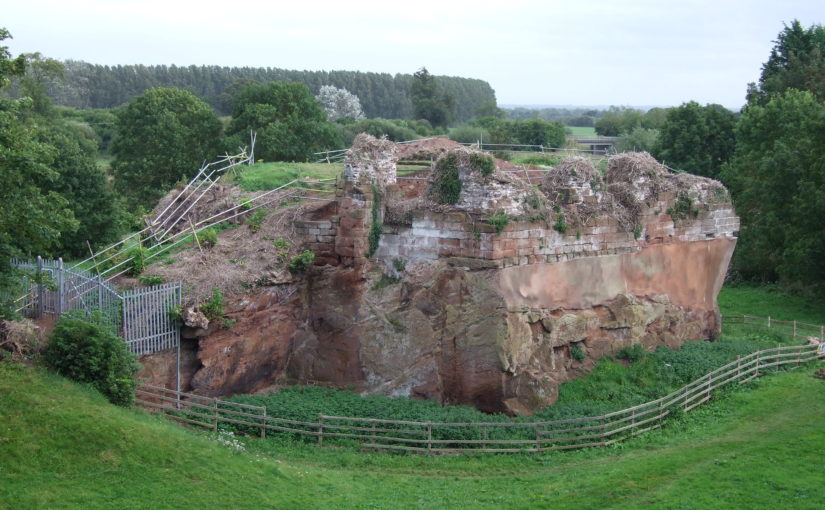
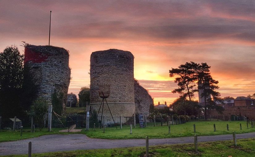
Feature image: Bungay Castle copyright Andrew Atterwill
References
Braun, H. (1934). “Some notes on Bungay Castle”. Proceedings of the Suffolk Institute of Archaeology and Natural History XXII.1, pp. 109–119.
— (1935). “Bungay Castle, report on the excavations”. Proceedings of the Suffolk Institute of Archaeology and Natural History XXII.2, pp. 201–223.
Braun, H. and G. Dunning (1936). “Bungay Castle: Notes on 1936 excavations and on pot- tery from the mortar layer”. Proceedings of the Suffolk Institute of Archaeology and Natural History XXII.3, pp. 334–338.
Gaffney, C., and Gater, J. (1990). Report on Geophysical Survey, Bungay Castle. Geophysical Surveys Bradford, Report 90/60.
Schofield, T. (2017) Bungay Castle, Bungay, Suffolk BUN 004 Geophysical Survey Report. Suffolk Archaeology Community Interest Company Report No. 2017/078.
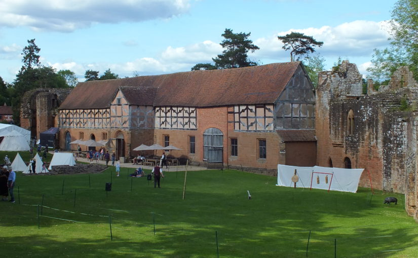
Castles were more than military sites, being political, judicial and economic centres too. Duncan Berryman of Queen’s University Belfast looks at one of those aspects, the important but little studied area of agricultural buildings in castles.
The domestic considerations of castles were as important to daily life as their defensive functions. Castles were also the centres of estates; Clare Castle (Suffolk) is a good example of an estate centre with manors in the surrounding region and further afield while Caister Castle (Norfolk) was the centre of a much more compact estate. Manorial centres were generally undefended courtyards of domestic and agricultural buildings. However, many of these were moated sites and their lack of defensibility might be debated. Sites such as Chalgrove (Oxfordshire) and Coolamurry (Wexford) had substantial moats and may have had complex bridges (Page et al. 2005; Fegan 2009). These complexes saw high-status accommodation sitting alongside the barns and animal housing that served as the manorial farmyard. Many smaller castles would have been the centres of smaller estates and would have also functioned as manorial centres. Agricultural buildings were vital to this operation and would have been found within baileys or associated enclosures. To investigate these buildings, it is essential to take a multidisciplinary approach by combining archaeology with documentary and pictorial evidence. The agricultural buildings have often been left unexcavated as they are seen as less important, and less interesting, than the domestic complexes.
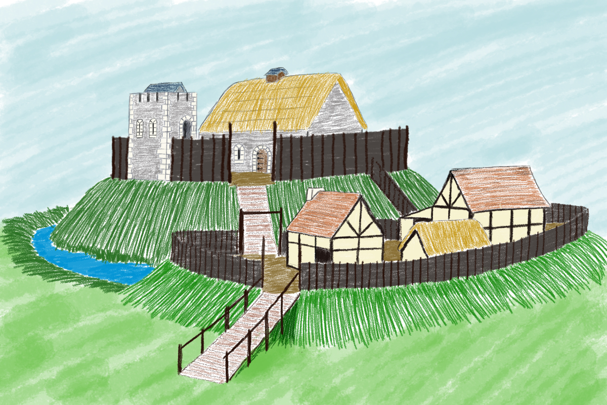
Artistic reconstruction of Clough Castle (Down). Many motte and baileys would have had a similar appearance, often with timber structures on the motte instead of the masonry buildings presented here.
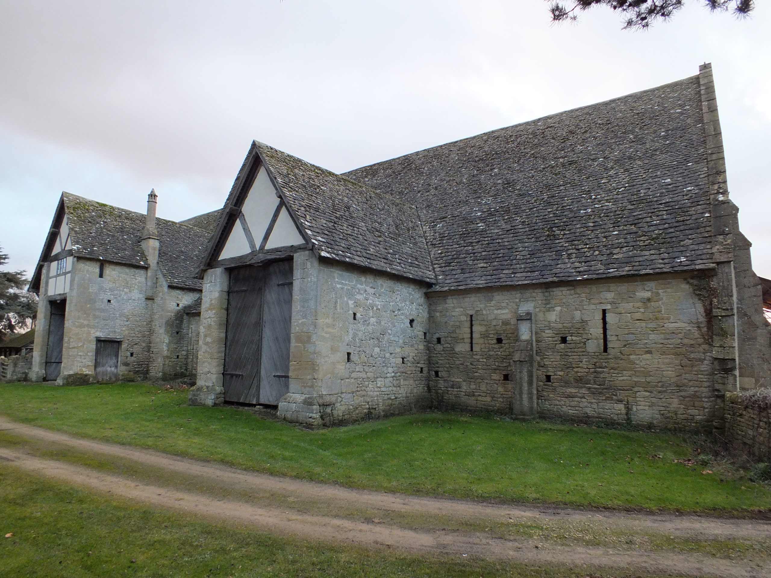
Documentary sources related to Ireland indicate that many smaller castle sites had agricultural buildings within the surrounding area. This is clearly illustrated at Cloncurry (Kildare), where an extent records that beside the motte was “an old haggard close [farmyard] in which there are two small granges [barns] each of eight forks … [t]here is also there, beside the gate an ox-house … [and t]here is a dovecote” (Murphy & Potterton 2010, 175). There is also a record of a barn of ten forks at Castlemore (Carlow), as well as a mill and other timber and masonry buildings (O’Conor 1998, 32). The forks referred to in these accounts are probably the cruck blades of the barn, thus ten forks produce a nine-bay barn that could be the equivalent size of a barn like Bredon (Worcestershire). At Lough Merans (Kilkenny), the motte sat on a promontory in the lake and had an associated bailey containing a granary, stables, and a sheepcote (O’Conor 1998, 30). The motte of Inch (Tippararery) also had a granary and sheepcote, additional buildings were stables, a fish-house, a dovecote, and a malt kiln (O’Conor 998, 29). These examples suggest that, in Ireland, castles were playing important roles as the centres of manorial farms and wider estates. The perceived need for a defensive motte may have been carried over from an earlier period, but it continued with the construction of tower houses in the fifteenth and sixteenth centuries (McAlister 2019, 28-35).
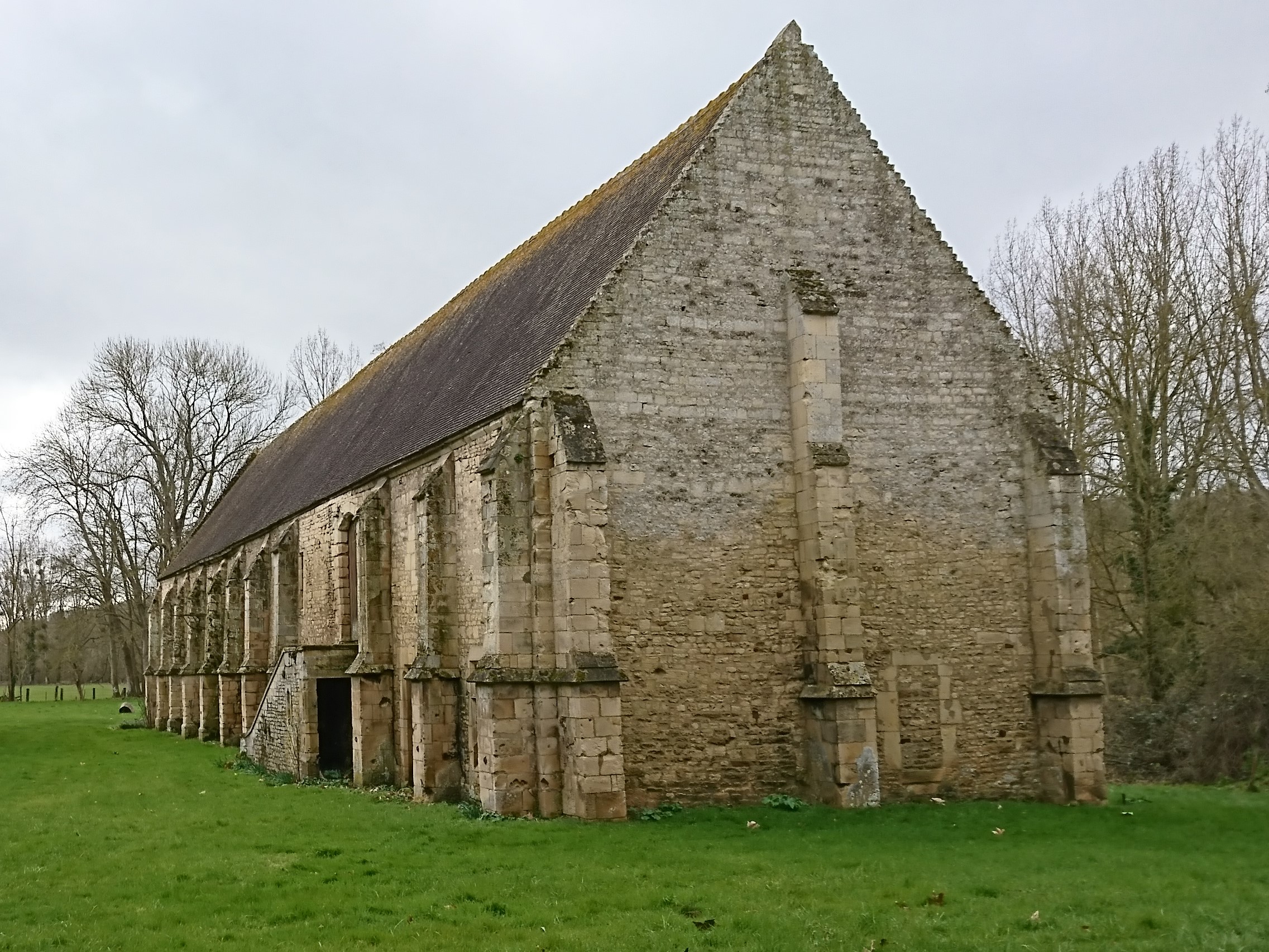
Bredon Barn (Worcestershire). Barns of a similar size were found within castle baileys. They would have been constructed from masonry or timber
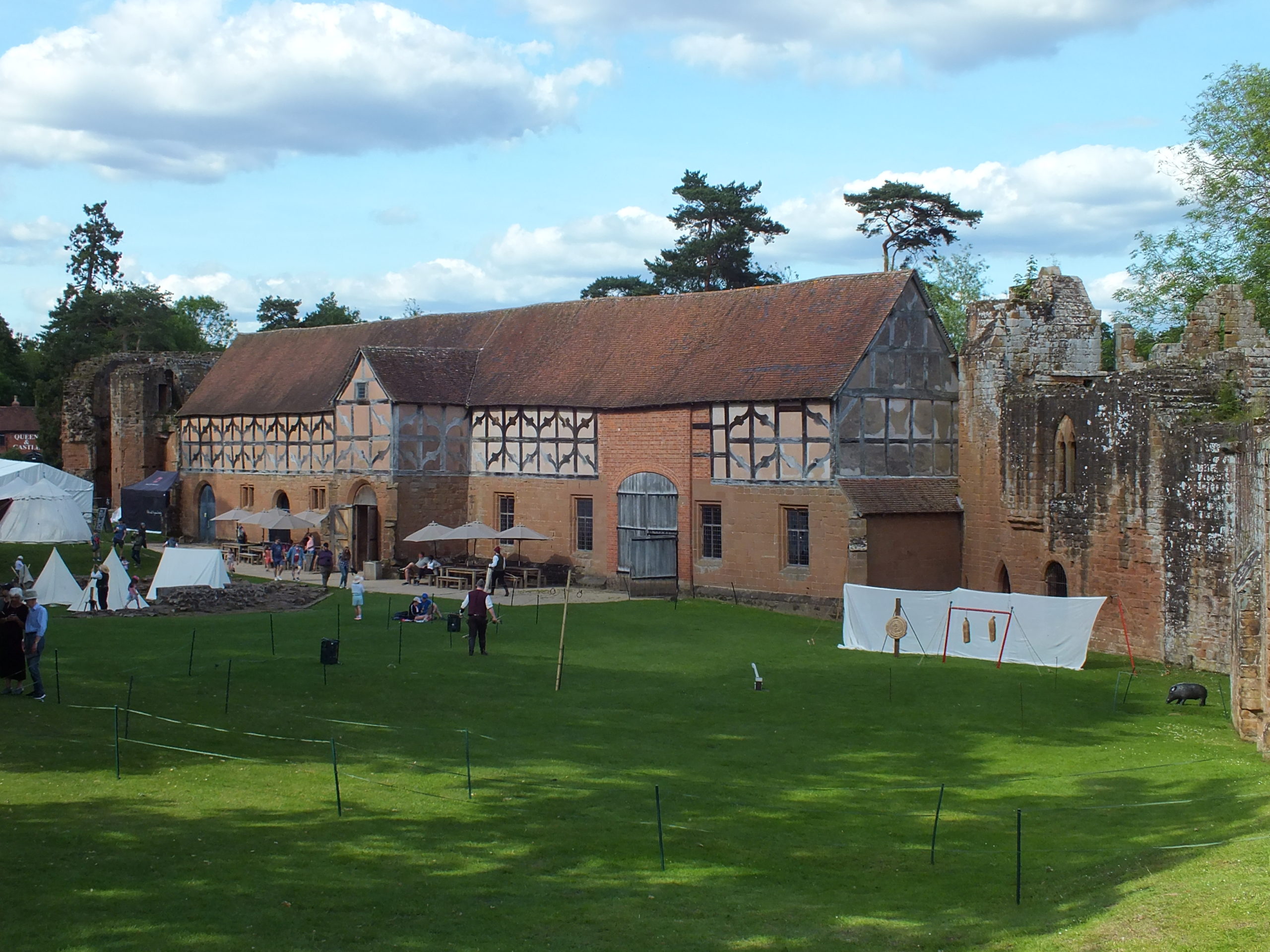
A brief survey of larger castles in England does show that these castles had a small number of agricultural buildings. The main buildings identified were stables, dovecotes, barns, and granaries. These buildings are unlikely to have functioned in the same way as they did in rural manorial centres, but they are a reminder that some agricultural processes occurred within the castle. Stables were obviously for housing the riding horses of the lord or king and their entourage, but they probably also housed the cart horses used by the castle staff to bring goods in from the market. There are records of stables at Hereford, Leeds (Kent), Leicester, Lincoln, Nottingham, and the stables of Kenilworth (Warwickshire) are still extant (Colvin 1963). The dovecote was an important source of food in the form of squabs (young pigeons). A dovecote was recorded at Dorchester (Dorset) and one has been identified in the south-west tower of Bodiam (Sussex) (Colvin 1963; Thackray 2003). The existence of barns might suggest that sheaves of wheat or barley were being brought into the castle and threshed there, providing grain for flour and straw for the stables and other floors around the castle. There is evidence for barns at Acton Burnell (Shropshire), Bamburgh (Northumbria), Hadleigh (Essex), Weoley (Warwickshire), and Pontefract (Yorkshire) (Colvin 1963; Emery 2000; Roberts 2002).
The stables of Kenilworth castle (Warwickshire). This was a particularly grand building, but stables were vital for the lordly lifestyle.
The c.1610 plan of Castle Hedingham (Essex) indicates that there may have been an agricultural complex beside the main castle enclosure (Emery 2000, 113). To the top of the map are buildings labelled stable and barn and an area marked barnyard, in manorial sites this would indicate a complex of crop storage buildings including several barns and a granary. Returning to Clare Castle, the 1325 accounts of the constable indicate that there were a pigsty and poultry house within the castle compound (Ward 2014, 64).
Agricultural buildings are found in areas away from the main domestic complex of the castle, and these areas are often left unexcavated. They were most often made of timber, and thus leave little trace in the archaeology compared to the stone-built structures elsewhere. It is possible that there were more agricultural buildings within castles, or close to them, and they have not yet been identified. This research highlights the importance of using documentary and pictorial sources alongside archaeology and reminds us that lesser castle complexes may have been surrounded by a significant range of buildings.
Colvin, H.M. (ed.) 1963, The History of the King’s Works Vol I & II (London: Her Majesty’s Stationary Office).
Emery, A. 2000, Greater Medieval Houses of England and Wales II (Cambridge: Cambridge University Press).
Fegan, G. 2009, ‘Discovery and excavation of a medieval moated site at Coolamurry, C. Wexford’, in C. Corlett & M. Potterton (eds), Rural Settlement in Medieval Ireland in the Light of Recent Archaeological Excavations (Dublin: Wordwell Books).
McAlister, V. 2019, The Irish Tower House: Society, Economy and Environment c.1300–1650 (Manchester: Manchester University Press).
Murphy, M. & Potterton, M. 2010, The Dublin Region in the Middle Ages: Settlement, Land-Use and Economy (Dublin: Four Courts Press).
O’Conor, K.D. 1998, The Archaeology of Medieval Rural Settlement in Ireland (Dublin: The Discovery Programme).
Page, P., Atherton, K. & Hardy, A. 2005, Barentin’s Manor: Excavations of the moated manor at Harding’s Field, Chalgrove, Oxfordshire 1976–9 (Oxford: Oxford Archaeology Unit).
Roberts, I. 2002, Pontefract Castle: Archaeological Excavations 1982–86 (York: West Yorkshire Archaeology Service).
Thackray, D. 2003, Bodiam Castle (Swindon: The National Trust).
Dr Will Wyeth, Property Historian at English Heritage, previews the geophysical survey, funded by the Castle Studies Trust, in order to learn more about the landscapte around Warkworth castle.
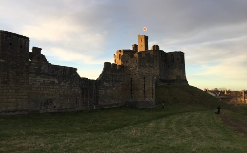
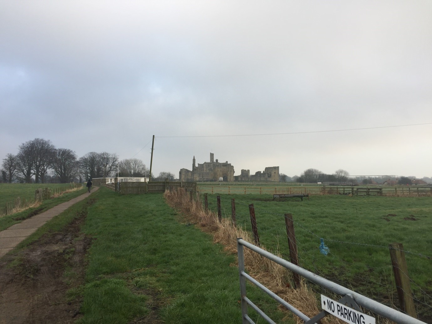
Following the success of a survey of Warkworth Castle’s earthworks in late 2020 as part of a scheme of reinterpreting this most palatial castle (report forthcoming), we on the English Heritage Warkworth project team have sought to expand upon our understanding of the medieval complex by turning towards its immediate landscape. Although much of the medieval landscape is not in the care of the charity, which looks after over 400 historic properties and sites across England, the landscape has tangible and nuanced connections which the project wants to explore. The castle is among the most prominent features in this area (Figure 1); its location adjacent to the lowest crossing point of the River Coquet means that low, somewhat boggy ground extends across the area south-east of the castle as the river widens to its mouth by the coastal village of Amble.
The plan of Warkworth Castle comprises a fairly typical motte and bailey, with stone superstructures of varying date and scale, and whose earliest iterations date from the late 12th century. While the antiquity of the settlement of Warkworth – laid out upon the north-south ridge of raised ground within this loop of the Coquet – is not known for sure, what is apparent is that the castle respects and influences the configuration of burgage plots and the coastal road ultimately linking Newcastle-Upon-Tyne and Berwick-Upon-Tweed. A walk around Warkworth village proper shows there are several important places and features which both relate to and indeed enrich the castle story.
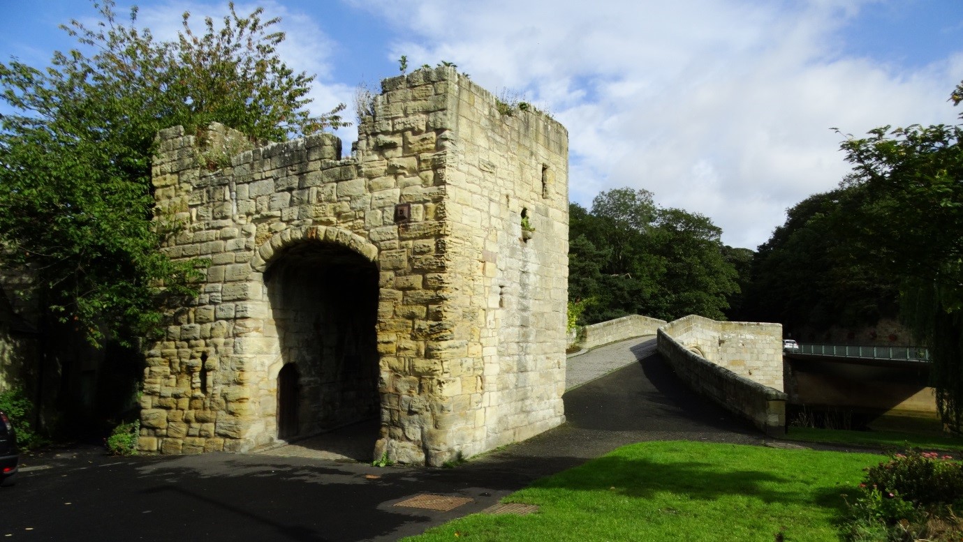
The church of St Lawrence, itself probably constructed on the site of an earlier medieval church, is located mere metres away from the late 14th-century fortified bridge (Figure 2) which spans the northern extent of the river’s loop. The identification as a ‘fortified bridge’ is perhaps misleading. Thought to have been completed around the time the Great Tower at Warkworth Castle was finished, the bridge may be better understood as a toll collection station, though its administrative and security characteristics are not necessarily contradictory.
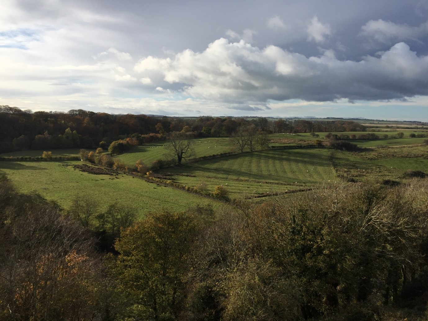
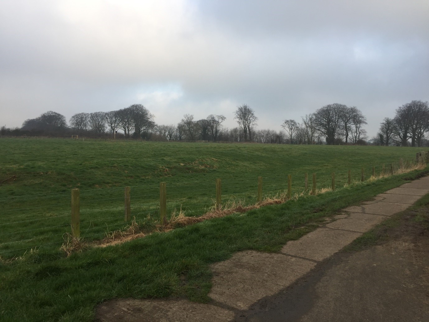
To the north, the coastal road carries on towards Alnmouth and onto Alnwick. It is in relation the immediate south and west of the castle, however, to which the Castle Studies Trust generously agreed to fund a further season of geophysical survey. Fields here testify to a legacy of cultivation which may be medieval in origin; traces of ridge-and-furrow are apparent immediately south and south-west of the castle (Figure 3), as well as in an area of ground rising gently from the river terrace, west of the Great Tower, across the river proper (Figure 4).
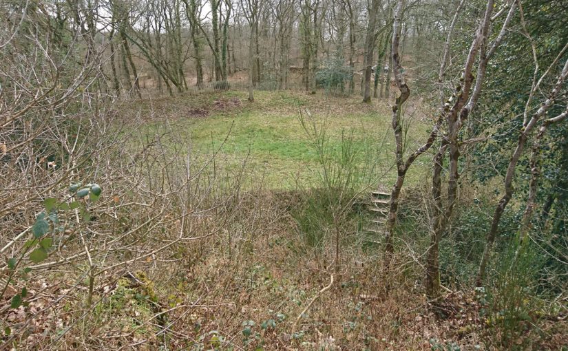
This new geophysical survey targets a cluster of fields adjacent to a modern pedestrian route to the castle which may fossilise a medieval antecedent (Figure 5), which would substantiate theories about the architectural orientation of major elements of the southern curtain wall of the castle towards the south-west. It also looks to locate with confidence the position of a suspected medieval hunting park boundary and access gate, which are sporadically referred to in manorial documents associated with Warkworth Castle in the late medieval period, but whose origins may lie in the 12th-13th-century, or (when considering place-name evidence) earlier still. Currently the park boundary is probably represented by a linear bank (Figure 6) with a southern return going westwards.
One of the fields in question bears the name St John’s Close, which had previously been thought to indicate the presence of a chapel here. In fact, the name likely references the field’s ownership by the Knights Hospitallers in the late medieval period, of uncertain origin but attested in a 16th-century return. The field is depicted in an estate map (which for copyright purposes cannot be displayed here) at the corner of a hunting park.
It is hoped that by firmly establishing the location of the medieval park boundary, any trace of a parallel routeway to the castle from the south-west, as well as the located of a gate into the park, English Heritage will be able to better draw the connections between castle and landscape which are now acknowledged as central components of castle culture. In turn, this will allow the charity to tell a more informed and more nuanced story about Warkworth Castle and the people who lived, worked and died here and hereabouts in its long history.
In her new book Authority, Gender and Space in the Anglo-Norman World, 900-1200, Dr Katherine Weikert, Senior Lecturer in Early Medieval European History at the University of Winchester looks at how medieval manors reflected and shaped – and were shaped by – their occupants to express social authority. In this article she looks at the facinating if little known Motte d’Olivet.
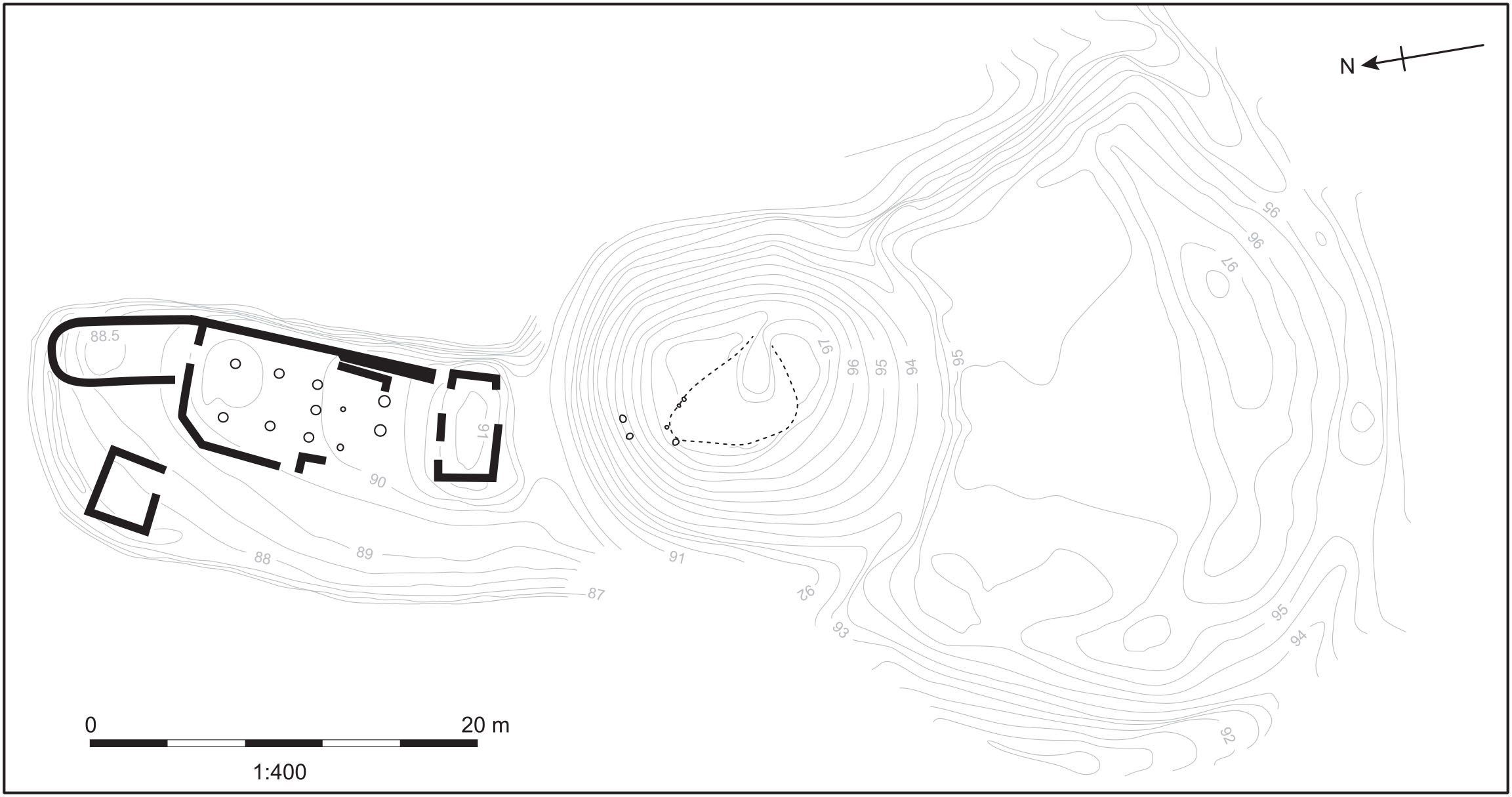
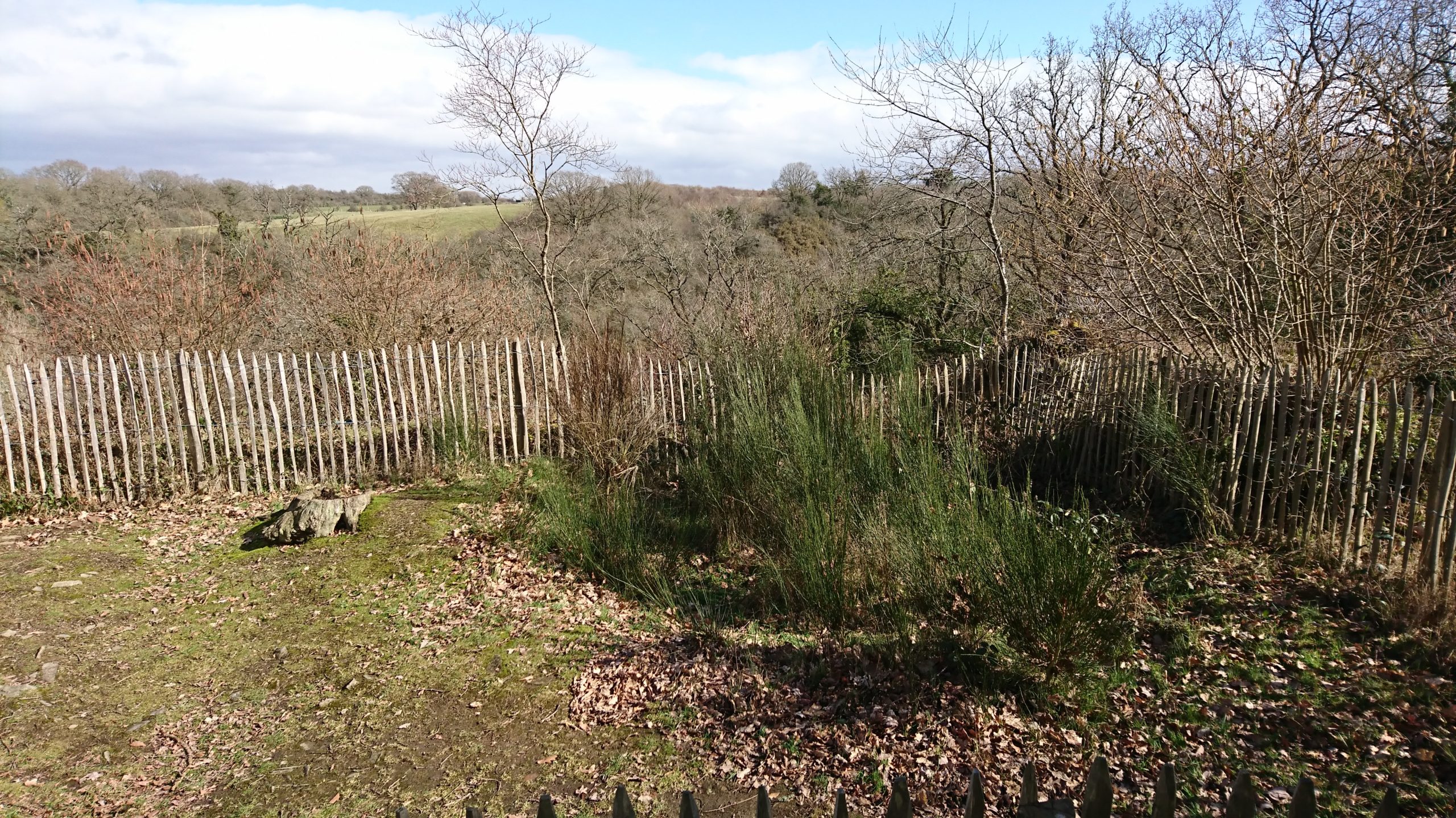
High in the lush forest of Grimbosq, Normandy, the remains of the Motte d’Olivet sit atop a lofty spur overlooking the Orne River valley. About twenty-two kilometres to the south of Caen, it’s a site that would be familiar to many castle-lovers: a man-made earthen mound, atop which formerly stood a wooden tower, with baileys on either side of it. A deep ditch around the motte kept it spatially and physically separated from both baileys. The motte-and-baileys take up the cramped, flat space on the point of the v-shaped spur surrounded by steep drops and small rivers on both sides (one charmingly called Ruisseau de Coupe-Gorge: essentially, cut-throat creek). The tower on the motte overlooked the whole area, and when the brush and forest was cut down around it, as it was in the eleventh century, the viewshed would have been spectacular. The Motte d’Olivet has long been considered a seigneurial residence, but its location, and the history of the man who built it, suggest a far less lofty purpose.
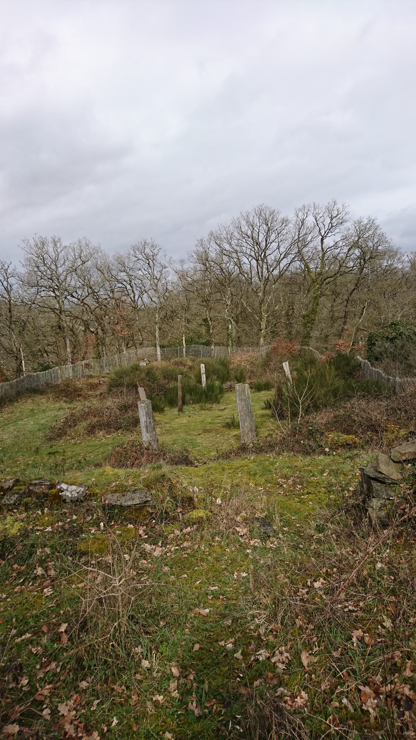
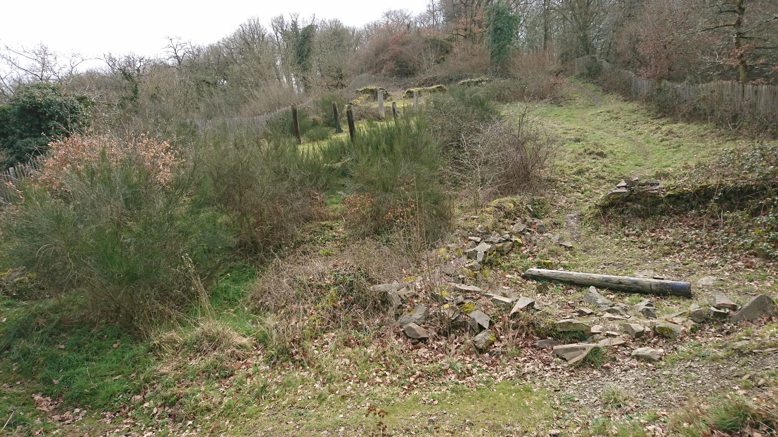
Image 1: Plan of the site of the Motte d’Olivet. Pighill Archaeological Illustrations redrawn from Decaëns 1981, published in Weikert 2020.Image 2: View north from the motte towards the River Orne. The stone remains in the foreground are suggested to be part of a gatehouse to access the motte, and the modern posts are placed at the location of the posts of an aisled building. Photo by the author.
The site was excavated by Joseph Decaëns and published in 1981, though lingering questions remain about the castle and its builder. The elusive Erneis Taissan built the motte in the 1040s-50s during a period of conflict with his older brother Raoul. The Taissons come to greater prominence in Normandy in the twelfth and thirteenth centuries along Raoul’s line; Ralph Taisson, for example, was King John’s seneschal in Normandy at the turn of the thirteenth century. But in this earlier period, the family is more difficult to uncover, and the remains of the Motte d’Olivet are some of the only physical presence we have of them from this time. Decaëns even described Raoul as ‘un personnage très important mais assez énigmatique’ (a very important, but very enigmatic person)!
Seeking evidence of the brothers and their history is an exercise of charters, patience and this castle. Decaëns ascribed the tension between the brothers to each receiving portions of their father’s lands after his death, and Norman charters indicate some expression of this frustration through the brothers’ conflicting patronage of local monasteries. For example, the elder Raoul founded the abbey at Fontenay (St-Étienne de Fontenay, on the Orne north of Grimbosq) in 1050, and its foundation charter, confirmed by William the Conqueror, lists properties Raoul gave to the abbey, all to the east of the Orne. Erneis – who patronised Fontenay but may have preferred the abbey at Fontenelle – held estates mostly to the west of Raoul’s. Grimbosq and Cesny(-Bois-Halbout) are but two of these, with his descendants’ title even named for them. The lines drawn between the properties of these two brothers run straight through the forest where Erneis built his Motte.
Image 3: The remains of St-Étienne de Fontenay, outside of St André-sur-Orne, Normandy, founded by Raoul Taisson c. 1050. Photo by the author.
Regardless of the cause of the tension, the Motte is the most obvious indication of the brothers’ strife, which visibly plays out the Norman landscape. The Motte directly overlooks the boundaries and roads between Grimbosq – Erneis’ land – and Mutrécy – Raoul’s land – with a clear sightline to the valley to the north, and a ridge to its east leading to Mutrécy. With this in mind, alongside the size of the castle and particularly its distance and isolation from any settlement, the Motte looks less like a seigneurial castle and more like an outpost, a short-lived watchtower to keep an eye on one’s pesky brother. It’s deeply unlikely this motte was Erneis’ main residence, but instead a place for his men to watch the boundaries of his land.
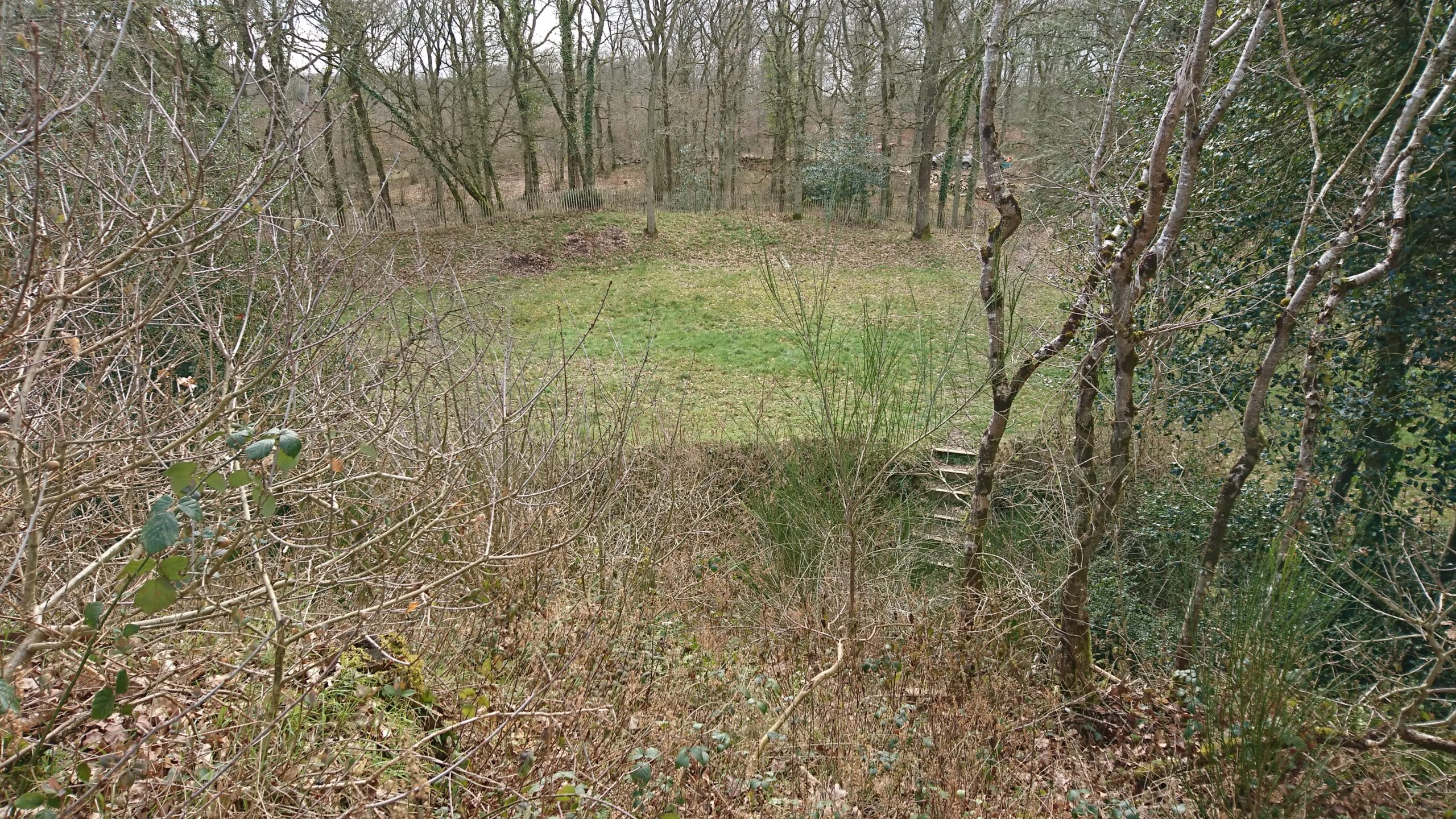
Image 4: The top of the motte, Mutrécy over the horizon. Photo by the author.
The northern enclosure holds a large aisled building, possibly two-storeyed, and additional stone rooms or buildings which have been interpreted as a sort of a gatehouse providing access to the motte, and a small separate kitchen. The apsidal room was previously interpreted as a chapel but this has recently been rejected by me on varying grounds (including location, orientation and charter evidence), which further indicates this place as less an elite residence and more an outpost. However, the state of the physical remains makes it unclear how to interpret not only the décor but quite simply the form and use of these buildings. The north bailey would probably have housed Erneis when he was there. But if that was this bailey’s primary intention, it would have only occasionally seen habitation, and more frequently seen the men on the watch accessing the motte via the gatehouse. The intention of this castle wasn’t in residency, but in the duties it performed for Erneis, in the watching and waiting done by his men.
Image 5: Remains of the ‘kitchen’ in stone, the modern post-holes marking the location of the large aisled building in the north bailey, with the motte (covered in scrub) in the background. Image by the author.
The castle’s activity would have been focused in the south bailey. The south enclosure, which held a stable and forge, would have hosted a number of people and animals, and alive with the sights, sounds and smells of a working yard – hot iron and manure, the hammer singing against the anvil. It would have been a site of activity at the castle, a place for the retinue who staffed this border outpost. Game pieces found in excavation mean men entertaining themselves, or perhaps simply passing the time, the way you’d play cards in an airport. As Susan Reynolds and many others have pointed out across the middle ages, military men of a sort gathered together to wait and watch would have probably had some training or practice to attend to themselves: we can envision the south enclosure for this.
Image 6: The south bailey from the top of the motte. Note the deep ditch surrounding the motte. Image by the author.
Wace tells us that the sons of the two men, Robert fitzErneis and Raoul (II) Taisson, both died at Hastings fighting with Duke William, and the rift between their two families was only repaired at this point. Erneis and Raoul (I) were probably already deceased and, to wit, the Motte was no longer in use by the FitzErneis line. Neither the Motte d’Olivet nor the warring brothers have been further investigated since the site’s excavation in 1981, and new questions about the place and its people can bring different views about what was once considered an elite house. What’s left of the brothers’ rift is just the landscape of this ruined castle, a lonely enclosure in an isolated place, high above the flourishing green forest, a lesson reminding us that castles have much to say about all the people who were once there.
Katherine Weikert’s new book, Authority, Gender and Space in the Anglo-Norman World, 900-1200, is available from Boydell & Brewer at http://boybrew.co/2YyHx2m. Use the special discount code BB870 for 40% off and free international shipping!
Grimbosq Forest is a part of the city of Caen. It is open to the public and filled with walking and mountain cycling routes, and sites such as an arboretum, a pet cemetery, and the Motte d’Olivet. The Motte is on the yellow walking route, and is unstaffed thought signage gives information about the site. There is free parking, and the forest is also on bus route 34 from Caen. More information can be found at https://caen.fr/annuaire-equipement/foret-de-grimbosq (French) or https://www.calvados-tourisme.co.uk/offer/la-motte-castrale-dolivet/ (English).