In September 2021, Dr Coralie Mills and Hamish Darrah from Dendrochronicle along with a team from Historic Envirnoment Scotland led by Rachel Pickering removed an original timber from the Great Tower at Old Wick in Caithness to help date the castle.
Following on from the successful removal of the piece of wood Dr Coralie Mills and her colleague Hamish Darrah have taken the wood back to their lab for further analysis. In three short videos they explain what they have been doing and what they have found.
James Wright FSA, buildings archaeologist and project lead on our Greasley building survey project takes a look at how buildings archaeology can help us understand castles.
The study of mediaeval castles, palaces or great houses and the discipline of buildings archaeology have closely related histories. The Castle Studies Trust has asked me, as a buildings archaeologist with a long-established research interest in such structures, to write a blog outlining these relationships.
Buildings archaeology has been defined as: ‘the study of buildings as archaeological objects in their own right… the development of structure… fabric, form and function’ (Morris 2000, 14). Ultimately, the subject demands the forensic methods associated with the careful unpicking of stratigraphy in below-ground archaeological excavation but applies those techniques to standing buildings.
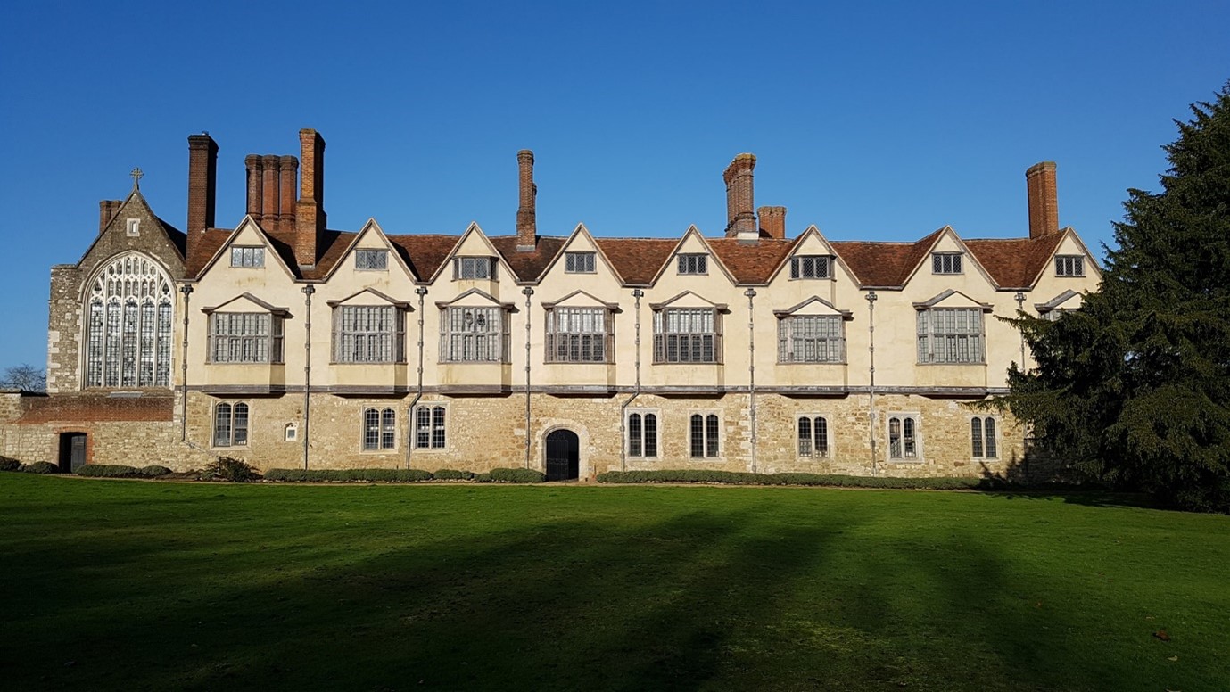
Survey work at Holme Pierrepont Hall (Picture: James Wright / Triskele Heritage)
Early Castle Studies: Military Historians
Although some antiquarians had demonstrated an interest in the structures of castles, most early castle specialists approached the subject from the archives. Scholars such as G. T. Clark (1884) and Alexander Thompson (1912) were concerned with documented building phases, ownership of castles and events which took place within their walls. Both authors were also very concerned with military matters and, for them, the castle was primarily a defensive fortification.
The military focus dominated castle studies for around a century. Philip Warner (1973, 8), a senior lecturer at the Royal Military Academy, summed this up when he stated the principal purpose of a castle was: ‘for delaying and dislocating an invading army.’ David Stocker (1992, 415-20) has pointed out that the prevailing notion that castles were primarily fortifications was perhaps due to so many castle scholars having seen military service.
Alternative perspectives can be traced back as far as Ella Armitage (1912, 8) who acknowledged the military uses of castles, but also emphasised their important domestic aspects as: ‘private fortified residences of great landowners’. This balance of military and residence can then be felt in the writings of Reginald Brown (1954), Colin Platt (1982) and Norman Pounds (1990).
Throughout much of the twentieth century the study of castles tended towards a sharp division of labour between historians and archaeologists who rarely collaborated. When the two disciplines were brought together the results were generally much improved – as happened with Howard Colvin and Philip Rahtz’s work on the royal palace at King’s Clipstone (Rahtz & Colvin 1960, 21-43). However, it was still the case that Colvin looked in the archives whilst Rahtz wielded his trowel and the standing architecture was largely overlooked.
Modern Castle Studies: A Holistic Approach
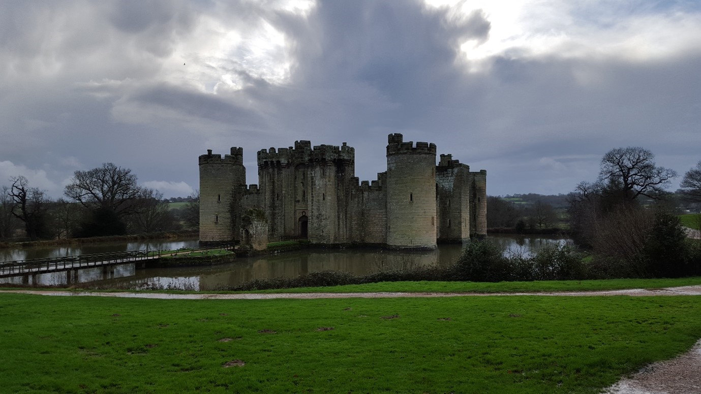
Subsequently, an emerging generation of researchers sought a more holistic approach which skilfully entwined archival sources, archaeological excavation, art and architectural history, landscape studies and the physical examination of standing buildings. Important re-assessments of sites, such as Bodiam Castle, placed emphasis on the symbolic and prestigious aspects of castles rather than the military versus residential debate (Coulson 1992; Everson 1996).
Bodiam Castle (Picture: James Wright / Triskele Heritage)
Buildings archaeology helped to revolutionise approaches to interpreting castles through the work of scholars, such as Philip Dixon and Pamela Marshall, who engaged with high quality, site-specific studies including Knaresborough Castle (Dixon 1990), Hedingham Castle (Dixon & Marshall 1993) and Newark Castle (Marshall 1998). Such work helped to build up a strong body of published fieldwork that chimed with a newly complex view of castles. Such projects placed castles in their contemporary moment as a mechanism for understanding the mediaeval lived experience.
With castle studies no longer shackled to rigid debates, the discipline was truly able to take wing. Oliver Creighton (2002, 2009) developed research into castle landscapes, Matthew Johnson (2002) took a strong theoretical approach and Robert Liddiard (2005) offered the wider context into which castle studies could be framed. Meanwhile, the multi-disciplinary investigation of individual buildings such as the Tower of London (Impey 2008), Knole (Cohen & Parton 2019) and Oxford Castle (Munby et al 2019) have remained central.
Knole (Picture: James Wright / Triskele Heritage)
Investigating Castles
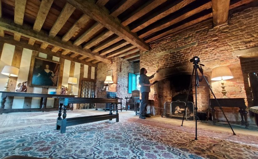
When approaching a new site, such as the recent survey of the late mediaeval courtyard house at Holme Pierrepont, I first like to walk around the entire building with the landowner or curator. This recce is one of the most important moments, as the site is gradually revealed, and I can listen to my companion’s impressions of a structure that they know intimately. However, it is important to maintain a level of detachment – misidentifications, mistakes and myths can creep into the dialogue. This is why I also have a preference for not doing a deep dive into the documents prior to visiting a castle. I find it useful to let the structure “speak” without what can often be conflicting archival sources distracting me.
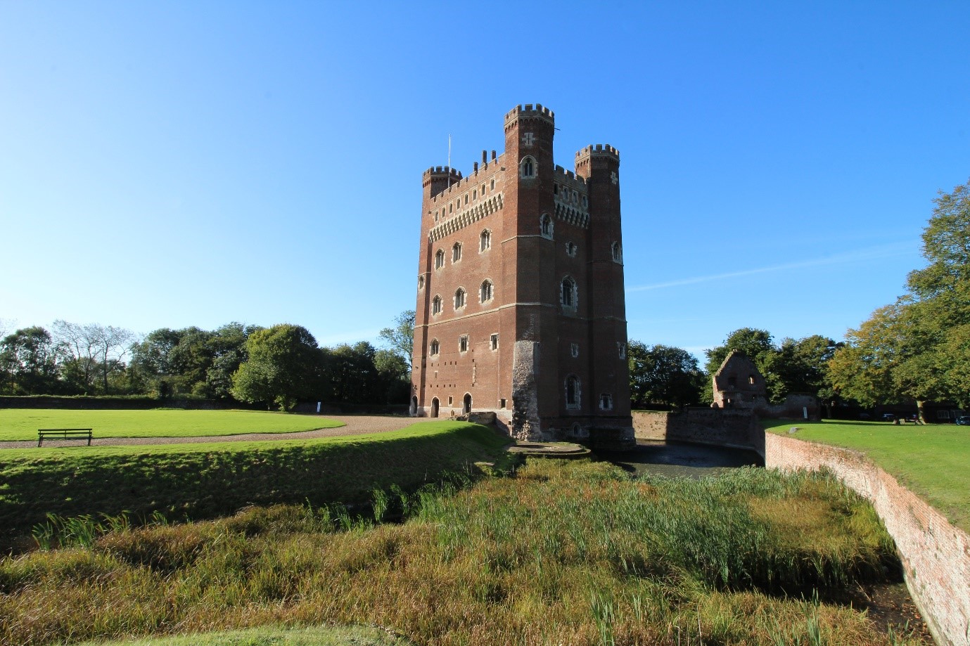
Then the real work begins! It is important to approach the survey methodically. When working at Tattershall Castle, I concentrated on the structures of each enclosure separately: starting with the gatehouse to the Outer Ward and gradually working my way, structure by structure, into the heart of the castle. This technique allowed a detailed progression of land-use to emerge in a sequence that would be recognisable to the lived experience of a mediaeval visitor to the castle. The last building that I tackled was the great tower – the most significant, complex and private space of the castle (Wright 2021).
Tattershall Castle (Picture: James Wright / Triskele Heritage)
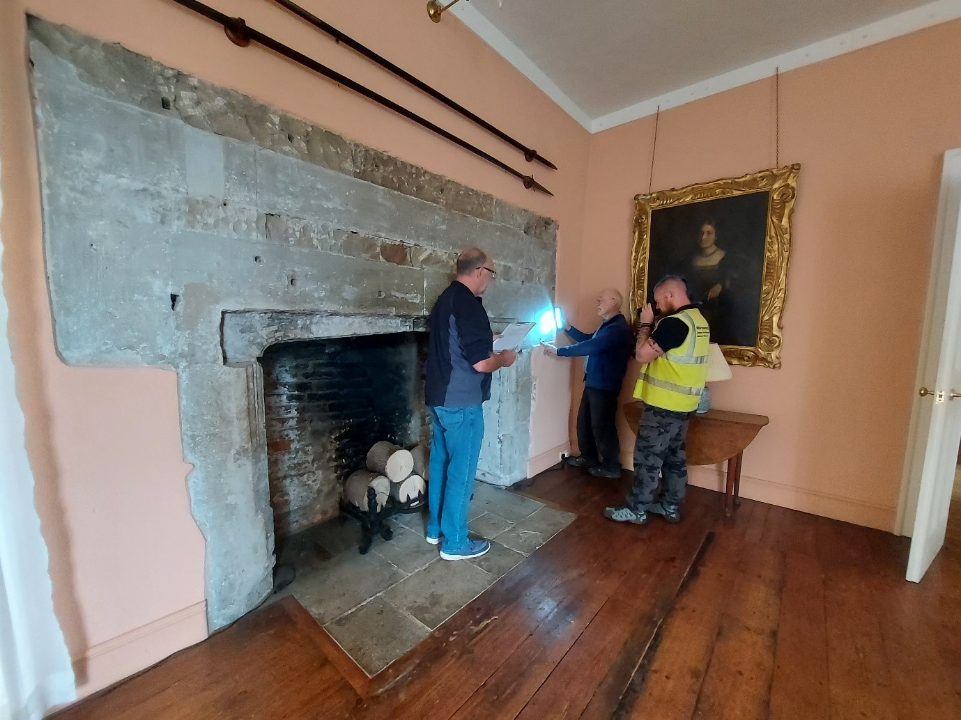
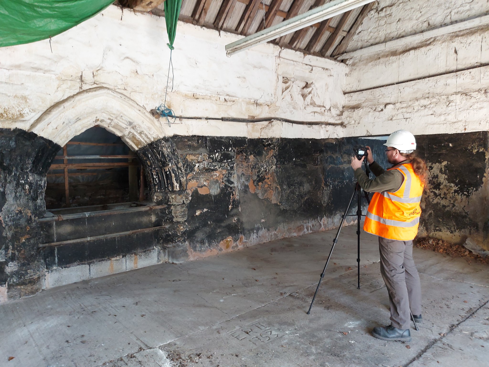
Although we can employ many pieces of equipment – digital cameras, drones, total stations, laser scanners and sampling for dendrochronology (all very useful for data gathering) – the most essential gear on site are the eyes and experience of the buildings archaeologist. Trained observation and interpretation are key. Therefore, my first task at sites, such as Greasley Castle, will be to either create measured drawings – floor plans, elevations and sectional-elevations – of the building or to check, add to and annotate pre-existing surveys. Quantifying what is actually present on site underpins analysis. We can also create new data by producing measured sketches or scaled drawings of features such as roof structures and areas of the building which are difficult to photograph due to spatial constraints.
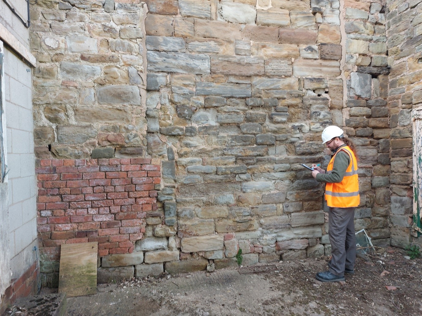
Observations on site might include noting the stratigraphical relationships between different phases of structures – a mediaeval window blocked in the post-medaeval period at Greasley Castle, the fifteenth century great tower at Tattershall Castle which abuts a thirteenth century mural tower (Wright 2021), or evidence for the wholesale reorganisation of roof structures at Knole (Sorapure & Wright 2013, 263-70). Depth is given to the survey by noting the stylistic typologies of particular structures – a Norman doorway at Kings Clipstone, thirteenth century window tracery at the Palace of Westminster or a late mediaeval chimneypiece at Nottingham Castle (Wright 2016, 34-37; Wright 2014; Wright 2017a, 19-23). Recording details such as mason’s marks, carpenter’s assembly marks and historic graffiti at Knole and Home Pierrepont Hall added to the understanding of the human agency behind the construction and occupation of the buildings (Sorapure & Wright 2013-14, 263-70).
Survey work at Greasley Castle (Picture: James Wright / Triskele Heritage)
Each space will be recorded systematically – usually (but not exclusively) starting at the bottom and working upwards, before looking at the exteriors. When all of the areas of the building have been drawn and annotated, it is time to move on to a comprehensive photographic survey, including both general and detailed shots. It is particularly important to capture all of the relevant data, whilst still on site to refer back to during the write up.
A standing building report will usually comprise two principal elements. Firstly, comes the historical background which establishes the known history of the structure based on a trawl of archival and published sources. At Tattershall Castle these included the 1231 licence to crenellate, building accounts from the 1430s and 40s, biographical data on its patron Ralph Lord Cromwell, parliamentary records of the slighting in 1650, antiquarian images showing its visual appearance in the eighteenth and nineteenth centuries and the letters and papers of Lord Curzon which related to the castle’s conservation in the 1910s (Wright 2021; Wright 2020). It is crucuial to tell the whole story of the castle from its inception right up to the modern day. Secondly, the archaeological analysis of the structure will link back to historical events which may have led to alteration of the structure of the castle. This analysis is typically ordered either chronologically or by physical space, sometimes a mixture of both. The text will be liberally illustrated with photographs, historic images and measured drawings.
There are many ways in which buildings archaeology can be reported. These include site reports, published articles, books, websites, blogs, social media posts, press reports, guidebooks, on-site interpretation, mobile apps, film-making and interpretation panels. A mixture of platforms has become the norm, but reporting is literally the most important part of any archaeological project. There is simply no point doing the fieldwork if you don’t tell other people what you have found!
Surveying at Greasley Castle (Picture: James Wright / Triskele Heritage)
Conclusions
The incorporation of modern buildings archaeology into castle studies helped to fill a fundamental gap left by projects that had previously concentrated on archival research or archaeological excavation. By taking a detailed approach to the analysis of standing structures, alongside other data streams, the scholarship was able to move on to vital new interpretations.
In my own work on castles, I have been able to apply buildings archaeology techniques to better understand the form, function, building materials, phasing, development and histories of entire sites such as Tattershall Castle or Kings Clipstone Palace (Wright 2021; Wright 2016). It has also led to significant discoveries, such as the identification of Edward IV’s personal livery badge on a chimneypiece at Nottingham Castle or graffiti connected to the Gunpowder Plot at Knole (Wright 2017a, 19-29; Wright 2017b, 78-80). Meanwhile, on my most recent sites, at Holme Pierrepont Hall and Greasley Castle, we are helping to provide an understanding of the archaeological phasing of structures which have previously eluded specialist attention.
Elements of this blog have been remodelled from Wright, J., 2021, ‘Background to English Castle Studies’ in Tattershall Castle: Building a History. Unpublished PhD thesis. University of Nottingham.
About the author
James Wright of Triskele Heritage is an award-winning buildings archaeologist. He has a long-lived research interest in mediaeval castles, palaces and great houses. He has worked on surveys of buildings including the Tower of London, Nottingham Castle, Knole, Holme Pierrepont Hall and the Palace of Westminster. He has written books on Tattershall Castle, Kings Clipstone Palace and the castles of Nottinghamshire. He is currently engaged in a building survey, funded by the Castle Studies Trust, at Greasley Castle.
Featured image: Buildings archaeology survey at Holme Pierrepont Hall (Picture: James Wright / Triskele Heritage)
References
Armitage, E., 1912, The Early Norman Castles of the British Isles. John Murray. London.
Brown, R. A., 1954, English Medieval Castles. Batsford. London.
Clark, G. T., 1884, Medieval Military Architecture in England Vol. 1 & 2. Wyman & Sons. London.
Cohen, N. & Parton, F., 2019, Knole Revealed. National Trust. Swindon.
Coulson, C., 1992, ‘Some Analysis of Bodiam Castle, East Sussex’ in Harper-Bill, C. & Harvey, R. (ed.s), Medieval Knighthood Volume 4. Boydell Press. Woodbridge.
Creighton, O., 2009 (2013 edition), Designs Upon the Land – Elite Landscapes of the Middle Ages. Boydell & Brewer. Woodbridge.
Creighton, O., 2002, Castles and Landscapes. Equinox. Sheffield.
Dixon, P., 1990, ‘The Donjon of Knaresborough: the Castle as Theatre’ in Château Gaillard Vol. 14. Publications du CRAHM.
Dixon, P. & Marshall, P., 1993, ‘The great tower at Hedingham Castle: a reassessment’ in Fortress Volume 18. Beaufort Publishing. Liphook.
Everson, P., 1996, ‘Bodiam Castle, East Sussex: Castle and its Designed Landscape’ in Château Gaillard Volume 17. Publications du CRAHM.
Impey, E. (ed.), 2008, The White Tower. Yale University Press. New Haven and London.
Johnson, M., 2002, Behind the Castle Gate. Routledge. London.
Liddiard, R., 2005, Castles in Context. Windgatherer Press. Macclesfield.
Marshall, P., 1998, ‘The Twelfth-Century Castle at Newark’ in Alexander, J. (ed.), Southwell and Nottinghamshire: Medieval Art, Architecture and Industry. British Archaeological Association Conference Transactions Volume 21. British Archaeological Association. London.
Morris, R. K., 2000, The Archaeology of Buildings. Stroud. Tempus.
Munby, J., Norton, A., Poore, D. & Dodd, A., 2019. Excavations at Oxford Castle: 1999-2009. Oxford Archaeology. Oxford.
Platt, C., 1982 (1995 edition), The Castle in Medieval England & Wales. Chancellor Press. London.
Pounds, N. J. G., 1990, The Medieval Castle in England and Wales: A Social and Political History. Cambridge University Press. Cambridge.
Rahtz, P. & Colvin, H. M., 1960, ‘King John’s Palace, Clipstone, Nottinghamshire’ in Transactions of the Thoroton Societyof Nottinghamshire Vol. 64. Thoroton Society. Nottingham.
Sorapure, D. & Wright, J., 2013-14, ‘Water Court: smaller and quite demure’ – A recent building survey of a forgotten late medieval courtyard at Knole, Kent’ in Castle Studies Group Journal Volume 27. Castle Studies Group.
Wright, J., 2016, A Palace For Our Kings – the history and archaeology of a Mediaeval royal palace in the heart of Sherwood Forest. Triskele Publishing. London & Cheltenham.
Wright, J., 2014, Archaeological Assessment of Stonework on the River Thames Foreshore at Victoria Tower Gardens. Unpublished archaeological report. MOLA.
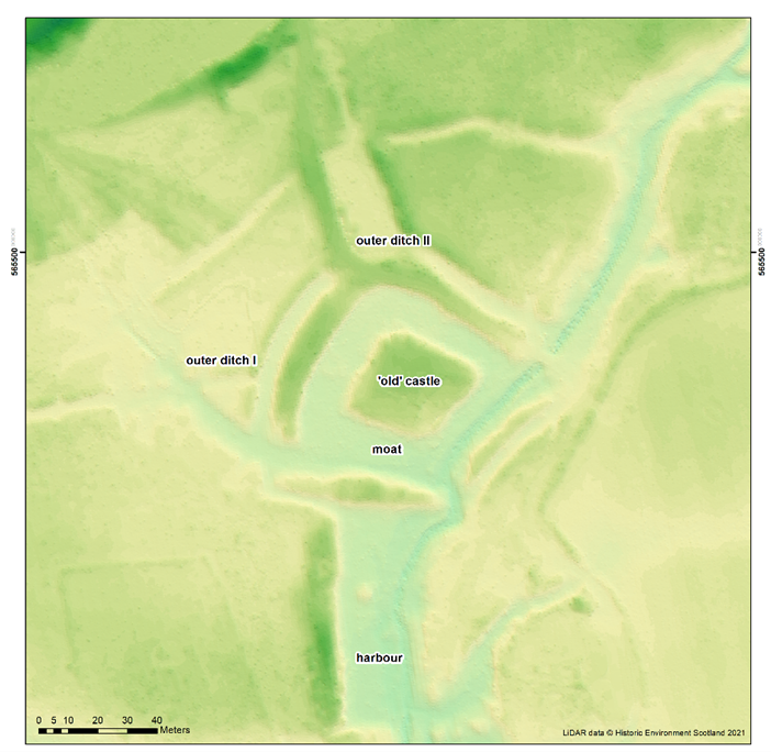
Thanks to funding from the Castle Studies Trust, Historic Environment Scotland are working with researchers Dr Richard Tipping and Dr Eileen Tisdall to understand the chronology and geography of extreme weather events in the high medieval period, and the effects they wrought on archaeological features that led to the abandonment of the old castle built in c.1229 in favour of the new built 200m away in c.1277.Here Richard Tipping gives an update on the fieldwork which too place last Saturday (2 October).
One of the great puzzles of old Caerlaverock is the so-called harbour (Image 1). It is south of the old castle, two metres lower, and just north of where we think the early medieval coastline was, so it’s difficult to think what else it could have been. But it’s never been independently dated, there are rumours that it was Roman, and there are knotty interpretative problems. One is that the floor of the harbour is at an altitude that would make it tricky to get more than rowing boats in and out in the Middle Ages; this is also a problem if the harbour was older. A second is that there is a fourth side at the southern end, which greatly restricts access. As Richard Tipping explains below:
The harbour has three metres of sand above bedrock. We don’t know how old the sand is. One idea is that it’s all very old – 8000-6000 years old. This would mean that the harbour was never deeper than it is now. Another idea is that the sand is of two periods, with an older bed covered by medieval sand: the same stuff that filled the moat of the Old Castle. And a third is that all three metres of sand are medieval in age. This would imply that the builders created a five metre deep harbour, which was then filled with sand as storm surges drove sediment onshore.
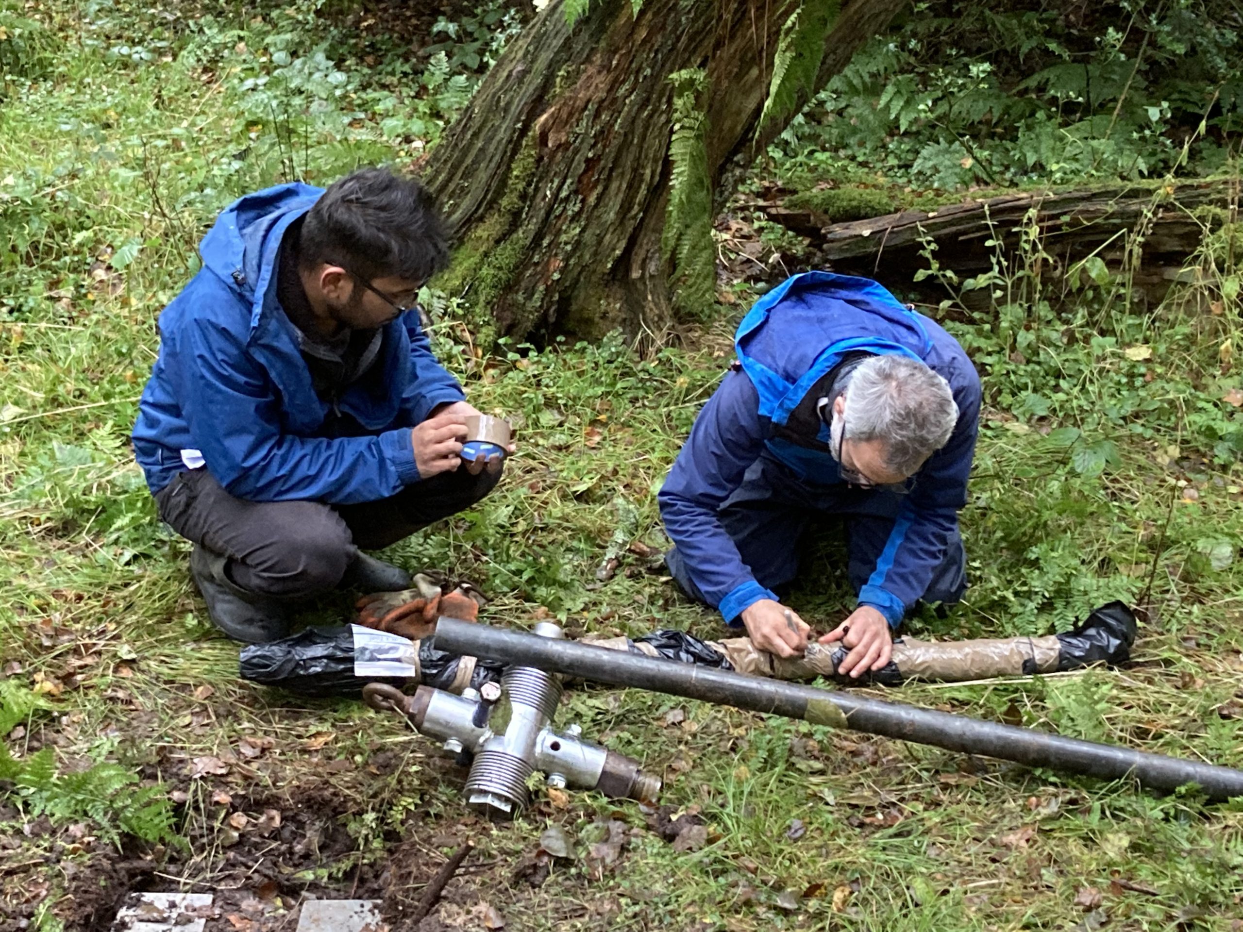
Dating of the sand is the answer. To this end, a team of eight (Richard Tipping and Eileen Tisdall from Stirling; Tim Kinnaird, Aayush Srivastava, Richard Bates and Laura Bates from St Andrews, and Morvern French and Steve Farrar from Historic Environment Scotland) assembled under gloomy skies and a more intimidating forecast to sample the sediment.
Here Richard Bates explains what they are going to do:
Richard Bates had a vibro-corer, a machine that went through three metres of sand as if it was butter: astonishingly impressive:
The three cores came out and were immediately wrapped in black plastic bags because sunlight, even that under grey clouds, cannot be allowed to shine on the samples. The reason for this bizarre behaviour is in how the sediment will be dated
Wrapping the sample
Tim and Aayush are specialists in optically stimulated luminescence (OSL) and infra-red stimulated luminescence (IRSL) dating. This is a kind-of accumulation clock. Over time, quartz and feldspar sand grains buried by sediment accumulate energy released from surrounding sediments at a constant rate. This energy is released if sunlight hits the sand, or under controlled laboratory conditions, when light at optical or infra-red wavelengths hits the sand. If the energy released can be measured, which is Tim’s and Aayush’s job, we can establish the age of the sand as Tim explains here:
The Castle Studies Trust grant will fund three OSL dates from the base of the sand, the middle, and towards the top. As soon as we learn the results, you will.
As Drs Richard Tipping and Eileen Tisdall along with Dr Tim Kinnaird of St Andrews return to Caerlaverock to carry out their final piece of field work this Saturday (2 October), Richard Tipping discusses what has happened so far.
Background
Earlier blogs have described the fieldwork, over the summer, at the Old Castle at Caerlaverock in south west Scotland. We have been testing the idea that several very large storm surges impacted the castle, persuading the occupants to re-build, higher up and further inland. That fieldwork involved recording sediments in the moat (Figure 1) and surrounding ditches, confirming that these sediment traps are full of silt derived, we think, from storm surges pushing sediment from the coast, through the harbour and into the moat. We’re checking the origin of the silt from diatom analyses, which can define water salinity. But we hadn’t found evidence that these storm surges were destructive, impacting archaeological features. Now we think we have.
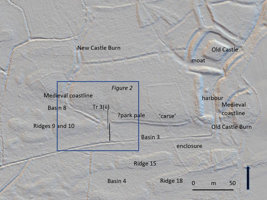
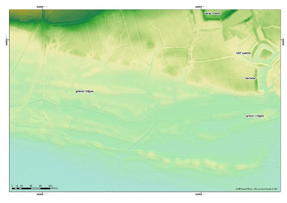
The ‘park pale’ is the name given to a ditched-&-banked enclosure that extends west from the harbour at the old castle for several hundred metres (Figure 1). It was constructed along a small cliff that marked the medieval coastline, separating mid-Holocene estuarine sediment, called ‘carse’ to its north and a series of very broad, parallel east-west trending ridges and basins constructed by medieval storm surges to its south (Tipping and Adams 2007).
Figure 1. Natural and archaeological features near the ‘park pale’ at Caerlaverock.
In Figure 1, a LiDAR image, Ridges 9 and 10, and Ridges 15 and 18 are seen. Between them, lagoon basins were trapped: Basins 8, 3 and 4 here. Some basins will be radiocarbon dated because peat formed when they were isolated from wave action.
In detail (Figure 2) the ‘park pale’ is complicated. There is an inner bank to the east, with a crest around a metre higher than the ground to its south. This is lost at a 25m wide gap and cannot be traced further west. Instead, a second, lower outer bank continues north west to the New Castle Burn (Figure 1). The outer bank has, in places, an outer and inner ditch. Another, 4m wide gap may be what Brann (2004) thought was an entrance.
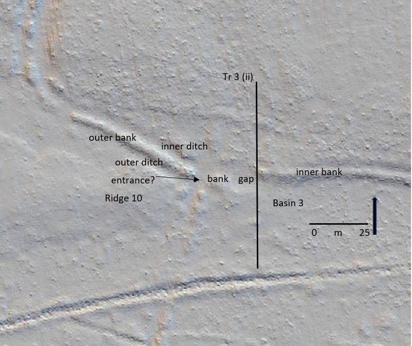
Tr 3 (ii) is the line of a 50m long sediment-stratigraphic transect of 24 hand-sunk boreholes from the ‘carse’ in the north, which the inner bank rests on, south across Basin 3 to the canalised Old Castle Burn. The transect was designed to test the idea that the 25m gap in the ‘pale’ is an erosional feature from storm surge impacts.
Figure 2. Features around the distinctive 25m wide gap in the ‘pale’
Stratigraphy
What Tr (ii) shows is that the low ground of Basin 3 is floored by bedrock less than a metre down. This is covered by well-sorted sand and then by poorly sorted coarse to very coarse sand and grit with common pebbles.This fills Basin 3, thickening shoreward. This is interpreted as a storm surge deposit, deposited in a high-energy marine environment. Boreholes on the inner bank, a metre higher than Basin 3, and 25m inland, also recorded thick gravelly sand, impenetrable at 90cm depth on the inner bank. This thins north but is still found 20m inland from the medieval coastline.
Narrative
There were at least two storm surge ridges formed before the events recorded in Basin 3. Basin 8 (Figure 1) was formed by the second storm surge, as yet undated. This created Ridges 9 and 10. These broad gravel ridges in turn protected the western ‘park pale’ from subsequent marine erosion (Figure 2). What is now the outer bank, with its associated ditches, probably represents the original boundary of the ‘pale’. The ‘pale’ pre-dates the storm surge event described here. It is shown by the sediment stratigraphy to be, broadly, medieval in age and, broadly, contemporary with the old castle.
Eastward, Ridges 9 and 10 merge with the ‘carse’ of the medieval coastline, leaving this part of the coast vulnerable to later storm surges. At this point, the outer bank of the ‘pale’ is lost. In its place are storm surge sediments. The ‘pale’ was eroded by the storm surge. This storm surge pushed at least 90cm of gravelly sand north onto the surface of the ‘carse’. The cliff may have been formed after this storm surge, by later erosional wave action. Gravelly sand was pushed or thrown 20m beyond the cliff. Waves also scoured the easily eroded ‘carse’, lowering the surface by around 0.5m, up to 100m inland.
Tipping, R. and Adams, J. 2007. Structure, composition and significance of medieval storm beach ridges at Caerlaverock, Dumfries & Galloway. Scottish Journal of Geology 43, 115-123.
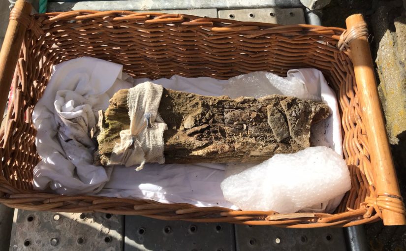
On Wednesday and Thursday 22nd and 23rd of September, a team lead by Rachel Pickering of Historic Environment Scotland and Coralie Mills undertook to remove the remains of wooden joist from the keep at Old Wick Castle. The joist hole was 8 metres above ground level. If successfully removed the joist was then to be taken away for testing and hopefully provide a date for it and the castle. In a slightly different blog than usual here are three short videos looking at how the removal process went.
As the Old Wick project gets underway, the project lead Rachel Pickering of Historic Environment Scotland explains what they are trying to find out and how.
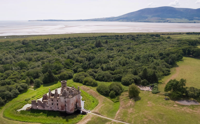
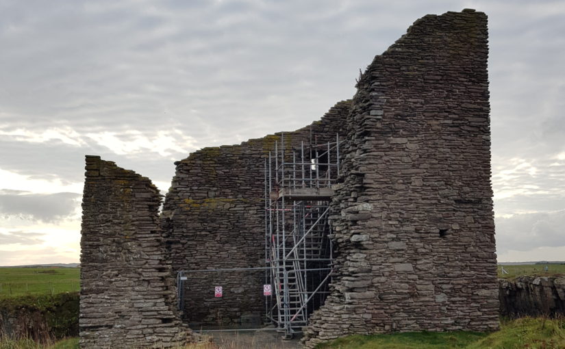
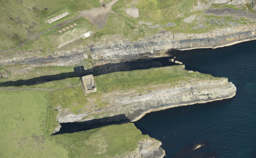
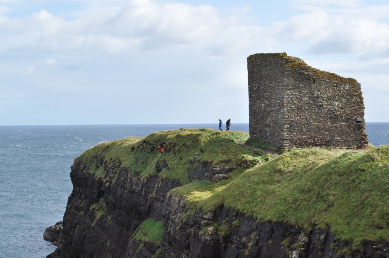
In the far northeast of mainland Scotland, on a narrow promontory, surrounded by cliffs on three sides, stand the ruins of Castle of Old Wick. The castle is one of Caithness’ most striking medieval sites due to its rugged location. But time has not been kind to the castle, and all that survives above ground is the stark stone skeleton of a once grand tower, within low-lying earthworks on the promontory behind. There are many unanswered questions about this castle, not least ‘when was it built?’.
Very little is known about the castle’s origin and development – there is limited documentary evidence relating to its earlier history and no diagnostic architectural features survive, making it very difficult to date. It was once thought to have been one of the earliest stone castles in Scotland, associated with Norse earls of Orkney and Caithness. However, more recently, scholars have questioned this, suggesting a 14th century date is much more likely for its construction.
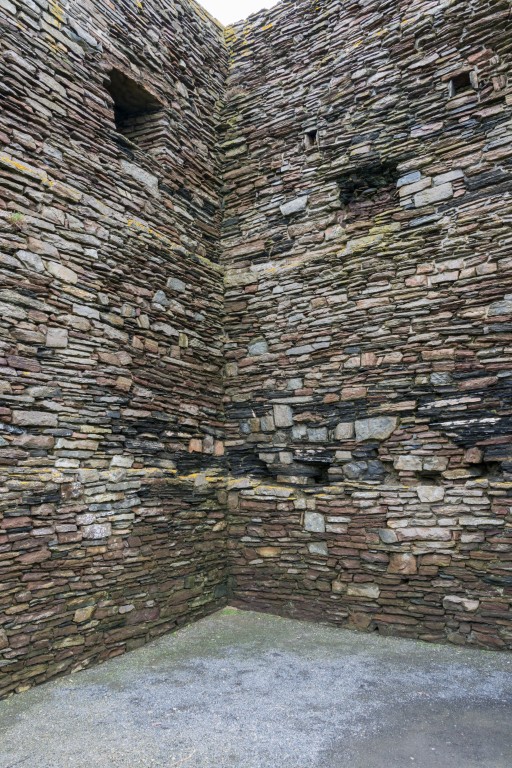
One tantalising clue survives that may shed light on its construction history – a single fragment of timber within a joist socket of an upper floor. The image below shows these joist sockets which indicate the tower had timber floors throughout. The sole surviving timber is increasingly at risk of decay as it is exposed to the elements. Our aim is to remove the timber and assess it for dendrochronological analysis – or tree-ring dating, before conserving the remains. From this we may be able to get a scientific date to indicate when the castle was built. At the very least, such a date may provide an age and provenance for the timber joist which provides an insight into phases of the castle’s development.
Thanks to generous grant funding from the Castle Studies Trust, HES and specialist contractor Dr Coralie Mills of Dendrochronicle will be carrying out new research this autumn, with the hope of recovering dating evidence.
The timber is believed to be oak, making it suitable for dendrochronological analysis, though it is in a very fragile state. It will be accessed using a scaffold and very carefully removed and wrapped before being transported to the laboratory in Edinburgh for detailed examination. Its condition and suitability for dendrochronological analysis will then be assessed. If it is not possible to analyse the rings of the timber due to its condition, then an alternative method will be undertaken using radiocarbon ‘wiggle matching’. This would involve taking several samples for high precision radiocarbon dating, allowing for a more accurately calibrated radiocarbon date for the timber.
We hope this research will shed light on the construction and development of Castle of Old Wick, by providing valuable scientific dating evidence. The project will also potentially support the on-going development of dendrochronological analysis within Scotland, as every new analysis can help to add to and refine existing tree-ring chronologies, which in turn supports future research.
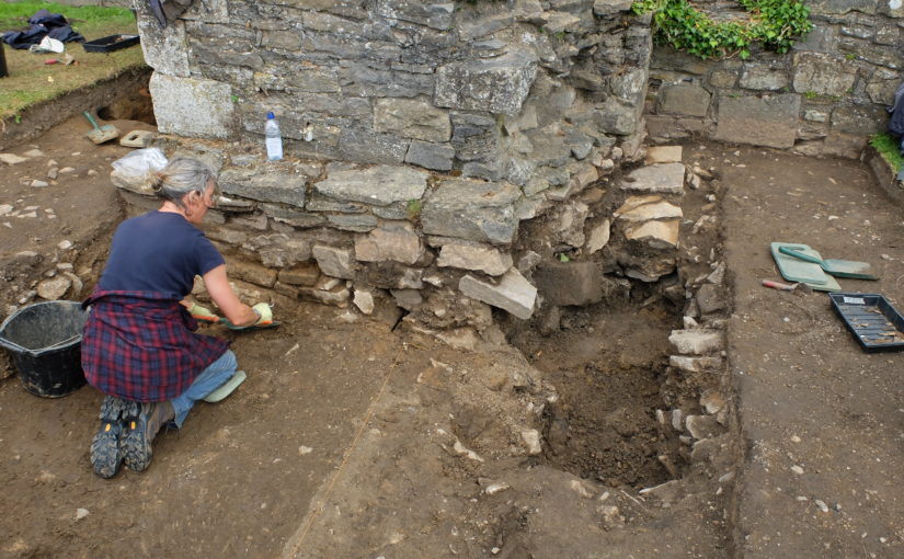
Excavation Director Jim Brightman of Solstice Heritage gives an update from the end of Wednesday 4 August
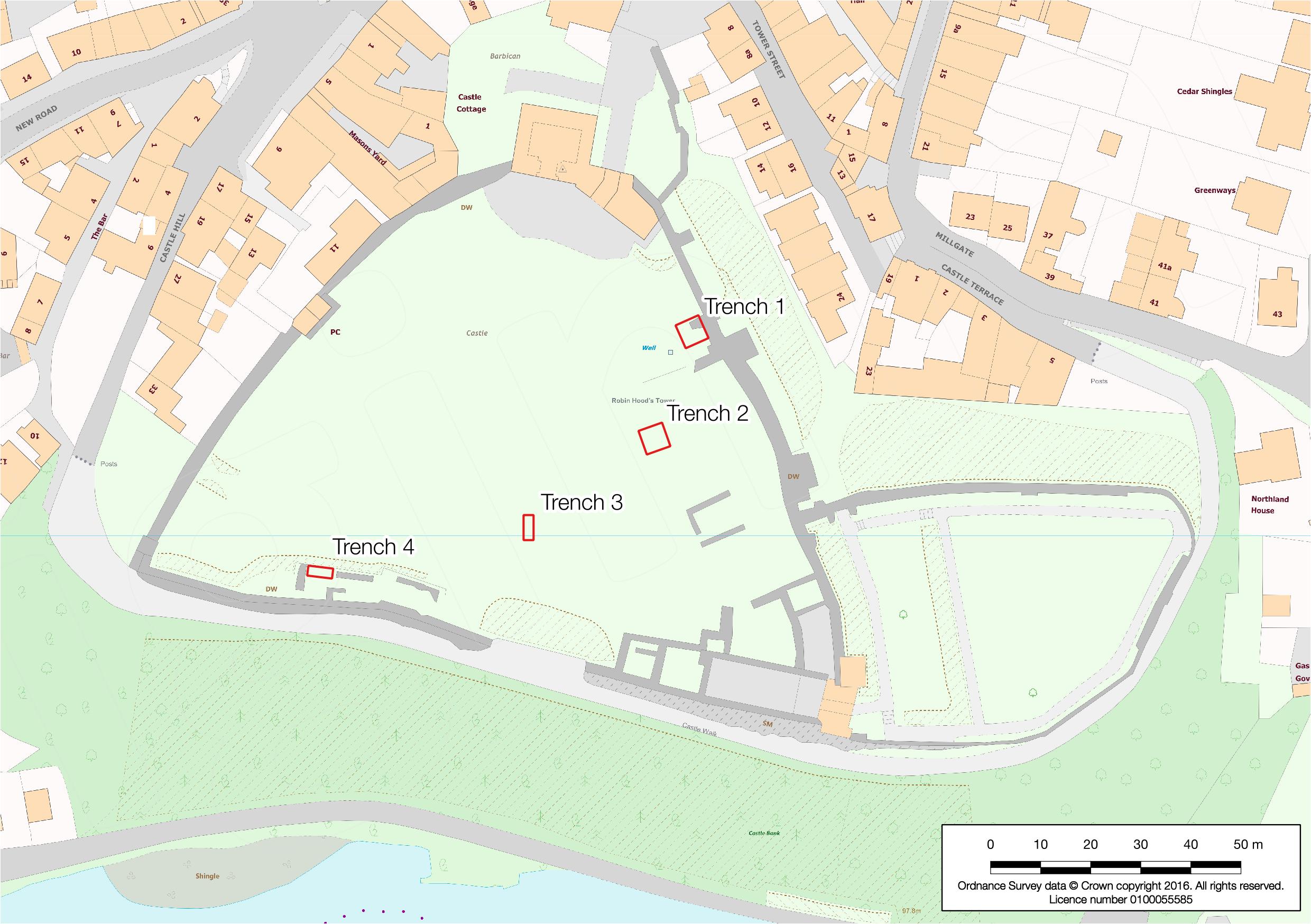
With things now very firmly heading towards the end of the excavation, we were able to arrange our logistics just right to let us to open a fourth trench on Monday. It was always our hope that we would be able to get to this point, though with the volume of archaeology (and more recent backfill) in our first three trenches, it’s been very much up in the air as to whether we would have time.
Fortunately, Trench 2 was completed, and we were able to set to de-turfing an area very close to the southern wall of the Castle and around some slightly enigmatic wall footings that had been consolidated and left above ground in the mid-20th century. It is not entirely clear what these walls might represent, and it has given us another bite at potentially locating the medieval chapel which we were hoping might have been in Trench 3.
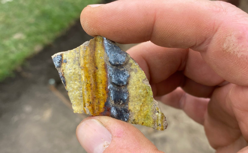
Although we are only a short way through the topsoil, we have already seen a real mix of finds from all periods of the Castle’s history: bits of glass and pottery potentially from the Victorian and World War I occupation, some lovely pieces of medieval pottery to show we were heading in the right direction and even a bullet casing made in 1974. What that was doing in the Castle, we have no idea!
The real star of Trench 4 (featured image) so far, however, has been the fragmentary remains of a really fine plaster or lime mortar floor—a hint that we may well be within the footprint of a well-appointed building. Hopefully, we still have enough time to get to the bottom of the remains in this new trench!
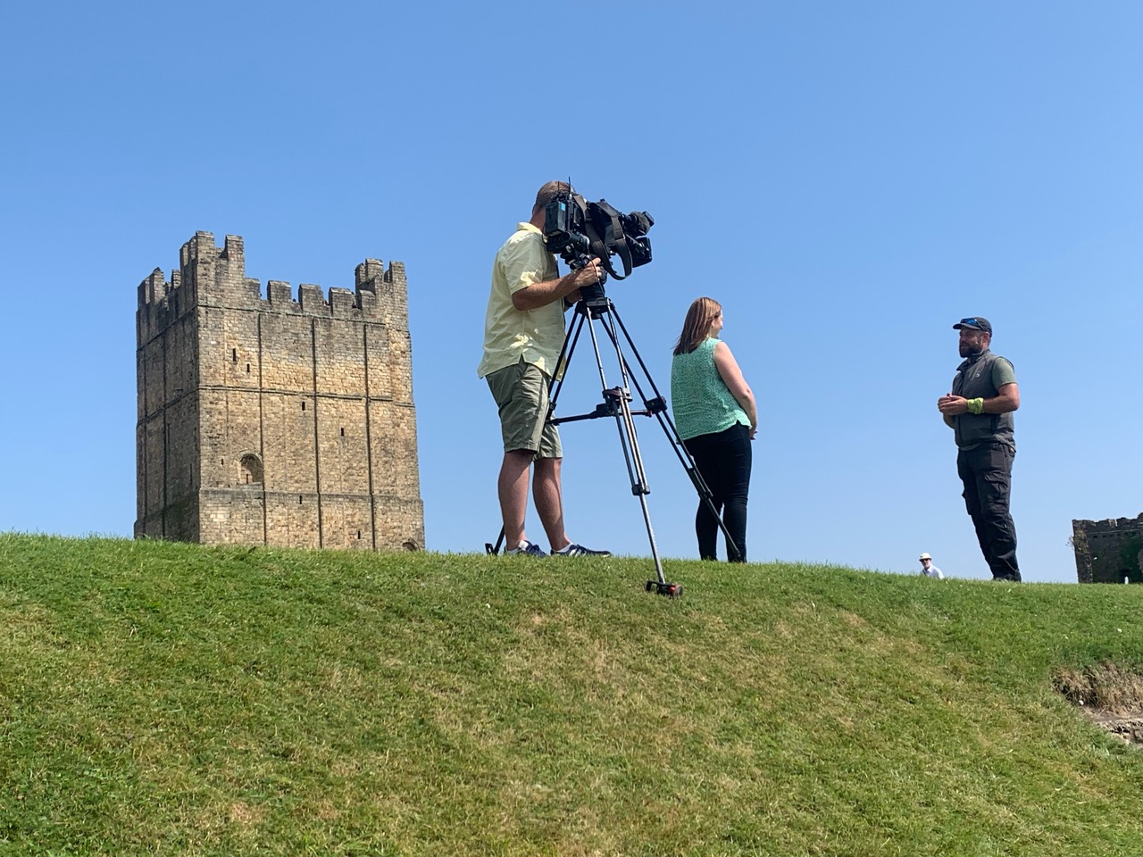
Jim Brightman with ITV film crew
The other excitement for the start of this week was the visit today by a team from our local ITV news programme. Word has spread quickly about the find of the William the Conqueror penny last week, and it was a lovely opportunity to spread the word a little wider still about the fantastic work that the volunteers have been doing through the course of the dig. For those who missed it (or are in a different ITV area), the full report can be found at this link:
By Excavation Director Jim Brightman of Solstice Heritage
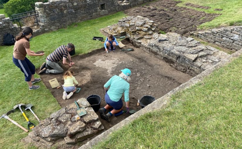
Reflecting at the end of the second week—two thirds of the way through our dig at the Castle—it’s been an amazing journey so far. After the excitement of the tv cameras on Thursday and Friday, we are all now taking a well-earned Sunday off, allowing some thinking time for the theories and interpretations. Yesterday, we were privileged to welcome a group from the Castle Studies Trust (one of the key project funders and hosts of this very blog!) who came to look round the excavations and offer some of their wonderful expertise and knowledge to help bring focus to some of the stories we are revealing.
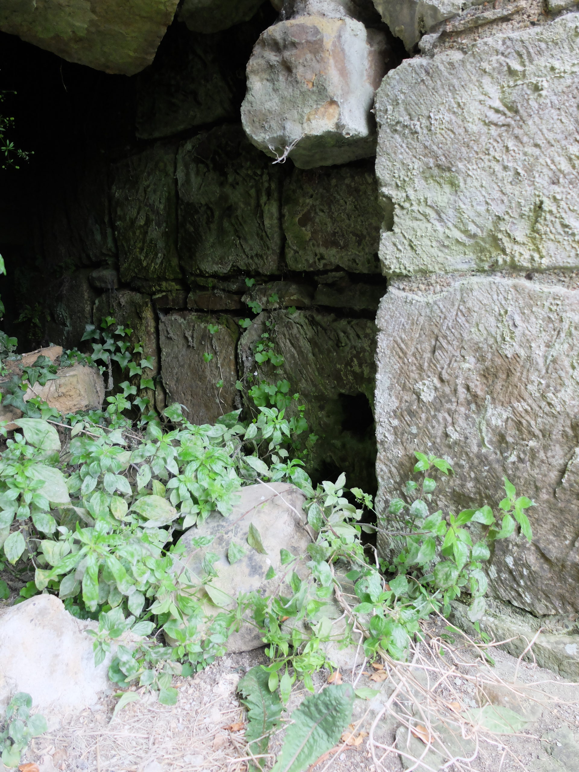
Entreance/exit of a likely small postern gate at the at the exterior of the curtain wall immediately beneath trench 1 (courtesy of Dr Peter Purton)
Trench 1 has proven to be the most complex in terms of the intercutting layers and structures (what archaeologists call ‘stratigraphy’). Although there is plenty of time left for our thoughts to change with new evidence, we currently think we have an original narrow door at the base of the curtain wall which was blocked during the medieval period. After this, a small square stone building was constructed against the wall, again at some point during the Castle’s medieval life. In terms of the large stone piers and low stone wall that we can see above ground, however, we are now confident that they are indeed 20th-century inventions built by the Ministry of Works.
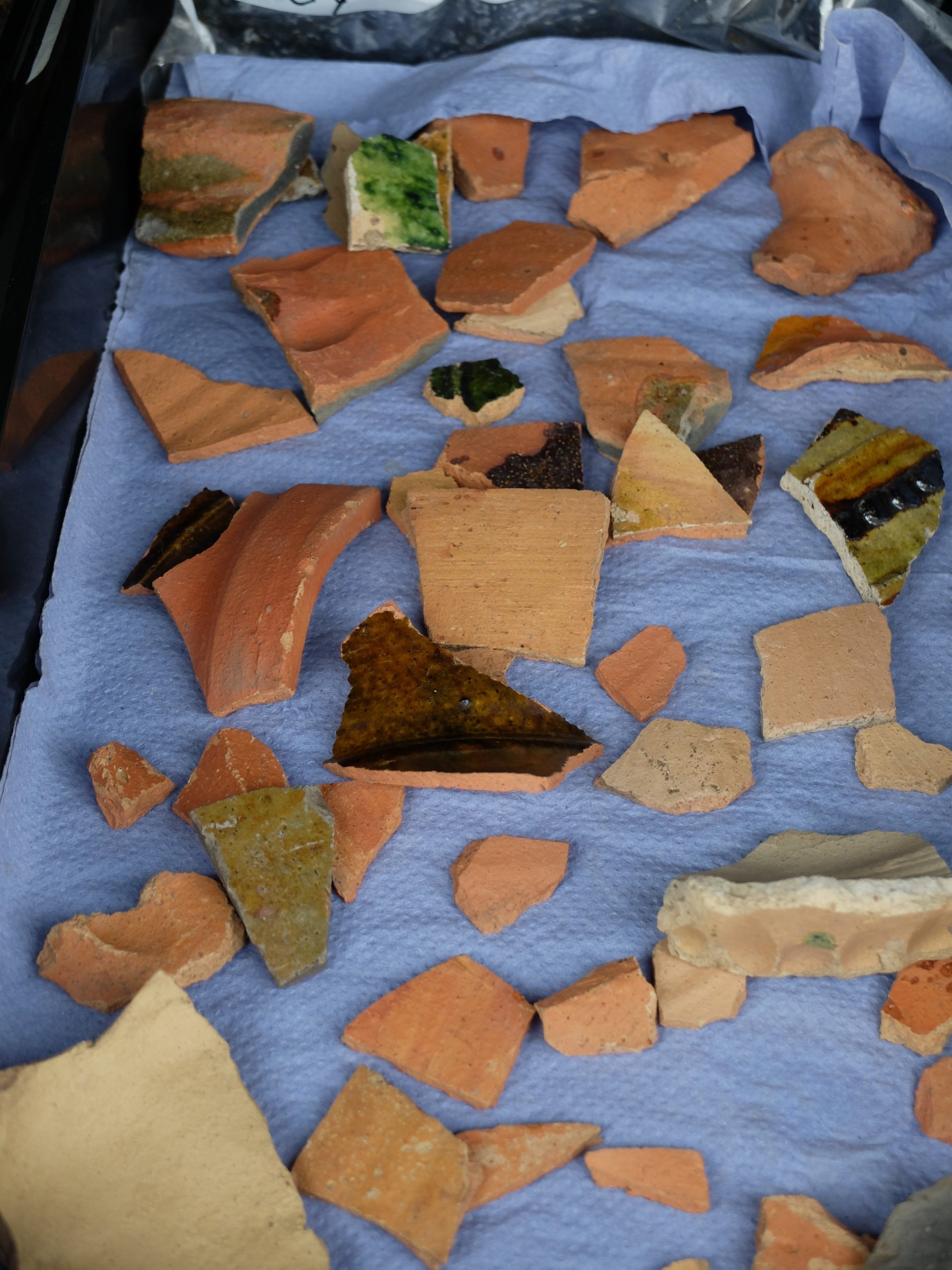
One of the most interesting aspects of Trench 1 has been the fantastic amount of fine medieval pottery that has come out of both the mixed topsoil and upper layers, and now from sealed medieval deposits. With a major acknowledgement to the eye and experience of Erik Matthews, we can confidently say we have not only great examples of local and regional pottery, but also of imported French and Belgian pottery. This really shows the importance of Richmond Castle as a seat of power during its medieval heyday and the interconnected nature of authority spanning the Channel in this period.
Range of pottery found in trench 1 (courtesy of Dr Peter Purton)
With the end of the project in sight, over the coming week I’ll also wrap up the stories for Trenches 2 and 3, so do keep checking back!
Project lead, Dr Richard Tipping, looks back at the second week of fieldwork he and Dr Eileen Tisdall are undertaking to try establish whether climate change did impact the re-positioning of Caerlaverock Castle.
Home again – after one of the most torrid week’s fieldwork I can recall: whilst Northern Ireland had the extreme weather warnings just to the east, Dumfries had day-time temperatures exceeding 26⁰C all week. And you’ll recall that I was inside a wood, where breezes never penetrate.
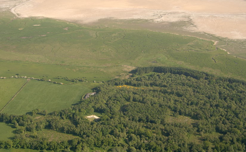
At Caerlaverock on the Solway coast, we are trying to work out the natural and human impact of huge medieval storm surges on the 13th century old castle. Last time I was looking at how the moat, and possibly the castle itself, was inundated with seawater and mud driven shoreward by storms. This week I focused on the coastline itself, away from the castle. Before the storms hit, the old castle was on the coast: it had a harbour. You can still walk along the degraded cliff to the west of the castle and imagine the seascape. After the storms, the coast lay some 250 metres south of the castle. A series of large gravel ridges, tens of metres wide, grew southward, beautifully revealed in LiDAR images that peel away the nearly impenetrable woodland.
A visualisation from the LiDAR data showing the gravel ridges that Richard has been investigating this week
Each of these ridges created shallow basins protected from tides. The harbour became pointless as a result. But all we knew from earlier work was that the youngest basin was formed around AD1400. How old were the earlier ones? Could we find sediment dateable by radiocarbon?
The fieldwork, I knew, would be hard. I’d looked for dateable sediment before, simply by coring the sediments in the basins, and found only one site; and now there was the woodland to contend with. All you can do is remain patient and optimistic: unglamorous, muddy and unspectacular work. The woodland meant that some basins couldn’t now be found, others where I couldn’t core systematically, and still others where systematic coring failed to find anything to excite. But I think we can date three of the eight basins and, usefully, these include the earliest basin and the basin that blocked the harbour. Stay tuned.
An image from the LiDAR data of the old castle and its landscape. The moat and outer ditches I and II have been the subject of Richard’s investigations over the two weeks.
But it was the ditches around the old castle that were the highlight of a difficult week. Sense was made of the moat. The builders formed one of the four moat sides from an existing stream channel: the moat here is a lot deeper because of this. But then the castle mound was not made parallel with this moat side. It does seem to be a very slap-dash construction. The attempted buttressing of the castle by stonework in the moat is shown here.
And we can now show that the mud of the storm surges penetrated beyond the castle, not by a great distance but enough that the old castle would have been surrounded in these extreme events, laid siege by nature while the younger new castle was laid siege by Edward I and the English in AD1300.
By Excavation Director Jim Brightman of Solstice Archaeology
So, we are very much at that point on the dig where we are in amongst the really fascinating medieval archaeology, but we are still teasing the answers out of what are turning into quite complex layers.
One place where we are still not sure about whether we are seeing medieval archaeology is in Trench 1: ironically the one trench sited right against the colossal curtain wall of the Castle! The small finds have been outstanding from the upper levels, including a selection of particularly well made and decorated medieval pottery—evidence of the high-status dining that would have graced the tables of the great and good. As we have investigated the substantial buttresses, however, it is becoming increasingly clear that a lot of the stonework around the trench may in fact be an invention of the Ministry of Works in the 20th century! It turns out that the enterprising work teams may have gone a little beyond their remit of consolidation and let their imaginations run free!
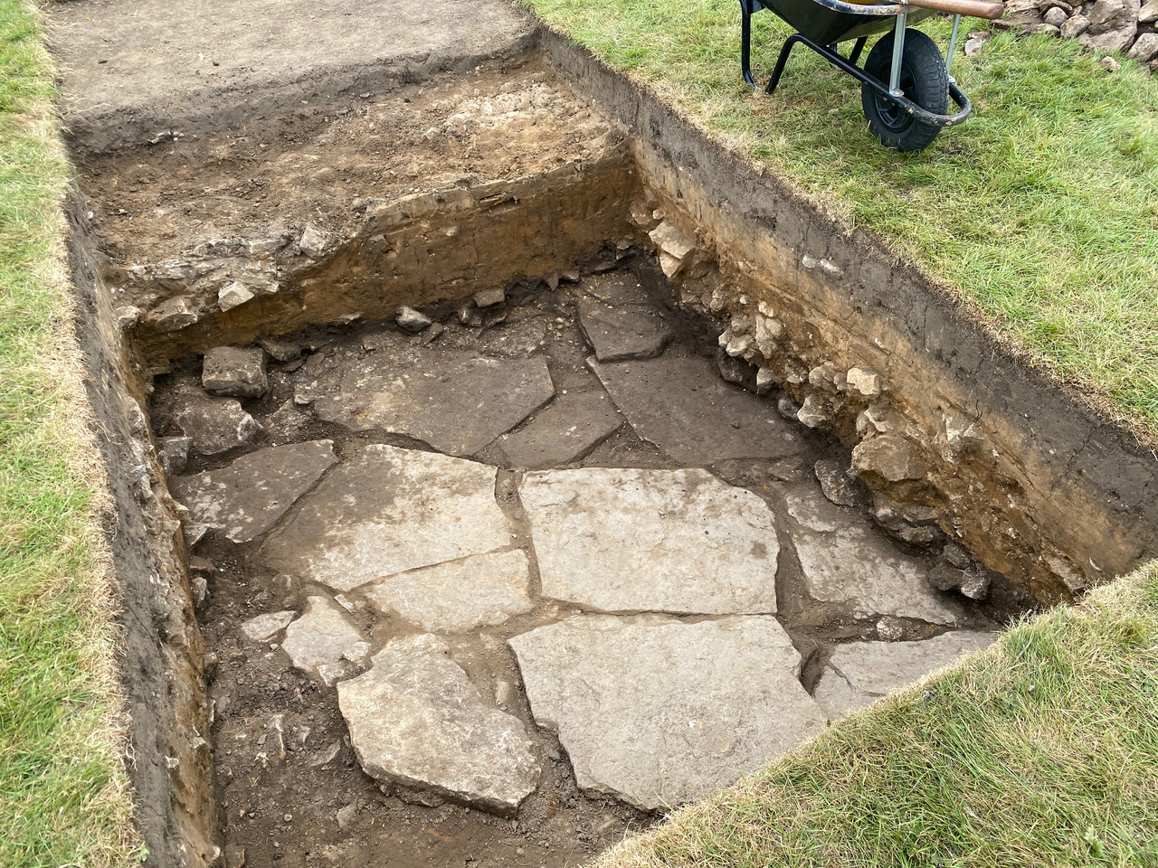
Trench 3 is the biggest mystery of all though. We have a clear sequence back through time: modern topsoil, early-20th-century building foundations, the Victorian and later parade ground and a post-medieval soil that had built up after the Castle had fallen out of use. Beneath this, we were hoping for the remains of a medieval building, and that is what we have found. Sort of.
Trench 3 flagstones
The exposed remains comprise a series of massive limestone slabs, not squared and dressed like flagstones but nevertheless laid with some skill. They look a little like a yard that we might see in front of a typical Yorkshire Dales farm, but there are a set of slabs laid at an angle as if forming the side of a shallow pond. If this wasn’t strange enough, the whole arrangement is curved in an arc, part of a much larger feature extending beyond the trench. So far, all our theories don’t quite fit with what we can see in the trench, so the only thing left to do is dig more—out and down—and see what is revealed!