As the team has now finished its field work at Caerlaverock Castle as part of a project to try and understand the impact of climate change on the changing of the location of the castle in the late thirteenth century, they are now testing the samples in their labs. Here, in two short videos, Tim Kinnaird shows what is involved in the luminescence dating process
Between 2018-2021, the Castle Studies Trust awarded Dr Duncan Wright three small grants to research the castle of Laughton-en-le-Morthen. The aim was to develop an innovative new research methodology to understand the near wholesale replacement of existing lords with incoming Norman tenants-in-chief physically showed itself post the Norman Conquest. Here Duncan explains what that has helped lead to.
In October 2021 the Arts and Humanities Research Council (AHRC) awarded Dr Duncan Wright (Newcastle University) an Early Career Research Grant of £200,000 in support of a new archaeological research project.
Entitled ‘Where Power Lies’, the project will undertake the first systematic examination of the physical evidence for elite centres in the landscape of medieval England between c. 800-1200AD. Many of these high-status places were developed as castles, and the research aims to identify the motivations behind choosing to build a castle at an existing lordly centre, when a site could equally be perpetuated as a manor house or else abandoned altogether.
The success of Duncan’s AHRC bid is partly thanks to the support of the Castle Studies Trust, who funded his research at Laughton en le Morthen (South Yorkshire) with three separate grant awards totalling almost £5000. The work at Laughton, which comprised geophysical and topographic survey, targeted excavation, and the commission of 3D reconstructions, not only helped reveal the complex history of the site but also acted as an important pilot and proof of concept for the new project. Indeed, Where Power Lies hopes to emulate the success of the research at Laughton, and will include some of the same survey techniques, but it will also scale up the focus to look at the national distribution of aristocratic centres with evidence for investment in both church and residential components.
Survey results of geophysical survey of Laughton-en-le-Morthen
After modelling the national picture, the Where Power Lies team will investigate a carefully selected sample of case study sites, which will be subject to topographic, geophysical, and standing building surveys. These investigations will allow us to reconstruct the biography of the case study locations in detail, and to explore how the character and expression of elite power invested in their residential and ecclesiastical complexes evolved over time. Working with the British Museum’s Portable Antiquities Scheme as an official project partner, the research will also produce a new profile of the artefacts of the aristocrats who built and occupied these sites.
By undertaking this work, Where Power lies will shift the focus beyond the relatively small corpus of excavated aristocratic sites of the period which continue to form the basis of our understanding. Instead, by embracing a range of digital technologies and non-intrusive survey methods, the projectwill create valuable new datasets at a number of scales. By generating this new information, the team will demonstrate how the transformation of power centres occurred on the ground, revealing whether castles integrated earlier components into remodelled layouts, or whether they caused greater destruction and a more fundamental schism with the past.
Excavation at Laughton showing remains of a ditch that ran next to a possible entrance way to the Saxon lordly centre.
The team will be led by Duncan as Principal Investigator, who will be accompanied by Professor Oliver Creighton (Exeter University) as Co-Investigator, and a Research Associate who will join the team for the duration of the project. Duncan would like to take this opportunity to thank the Castle Studies Trust for their generous support of his research at Laughton en le Morthen, which strengthened the AHRC bid significantly. He hopes the results of Where Power Lies will prove of interest to everyone associated with the Trust.
In 2020, the Castle Studies Trust funded Dr Karen Dempsey to undertake an innovative new line of research in castle studies, namely to explore the use of plants in castles in medieval Ireland. In this article, Karen explains what she and her colleague Dr Fiona MacGowan discovered.
Over the course of this Pandemic many people have a newfound or renewed appreciation for the green world that we live in. This might take material form by growing potted plants at home and if fortunate caring for a garden space of your own or somewhat less tangibly, the contemplation of changing seasons in your local park. The (anecdotal) health benefits we might feel from these activities are increasingly underscored by health professionals who assure us of the roles of green spaces in wellbeing. This connection is not a modern phenomenon – plants (and gardens) played a significant role in the diet, healthcare and spirituality of people living as part of castle households.
‘Sowing Seeds of Interdisciplinary Work’, the Castle Studies Trust funded project, showed how relict plants can deliver new insights into everyday life at medieval castles. Relict plants – understood to be the descendants of plants grown, cared for and used by (medieval) people – were identified through botanical surveys at four geographically diverse but culturally similar medieval castles: Adare, Co. Limerick, Castleroche, Co. Louth, Carbury, Co. Kildare and Castlecarra, Co. Mayo (as detailed in my previous blog post). As an initial step in researching relict plants, particular attention was paid to archaeophytes, those plants which arrived in Ireland pre-1500 CE. I believed that these plants may have participated in the various colonisation processes of the twelfth century. Their introduction could be linked to new gardening and other health practices especially those related to novel plant medicines which were emerging across Europe at this time but were perhaps previously unknown in Ireland.
Relict Plant Findings
Botanical surveys began during mid-2020 in the very wet months of June and July after a hot May.
Next site on our Relict Plants project @CastleStudies is Castle Carra Co.Mayo. Built by Adam de Staunton c. 1240. Castle with hall and chamber, with the vill, parish church and abbey c. 1km east. pic.twitter.com/yJISGh7DiL
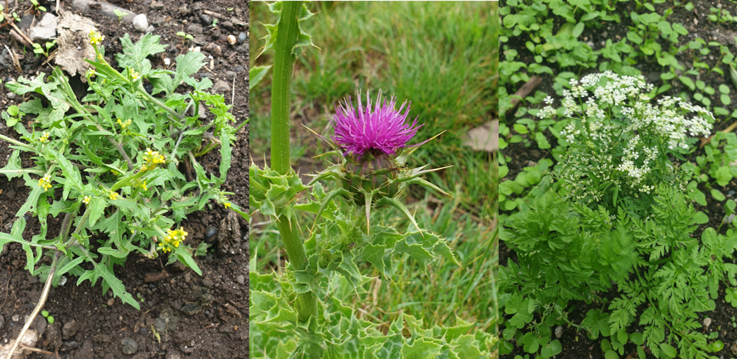
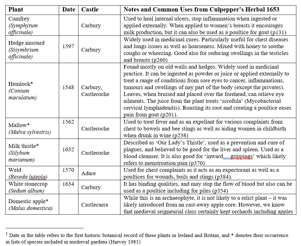
Over the course of the survey eight archaeophytes were revealed (Table 1) as well as a range of rare and common native plants. You can read Dr MacGowan’s botanical report here. These findings are significant: four of the eight plants were historically recorded as present in medieval gardens. The plants – comfrey, mallow, milk thistle and hedge mustard – are widely recognised as having medicinal properties (Fig 1). They feature in medieval recipes, continued as part of the tradition of plant medicine captured in Culpepper’s Herbal of 1653 and some, like milk thistle, remain in use today (see Table 1).
Figure 1 Milk thistle at Castleroche; Hedge mustard and Hemlock (Conium maculatum) at Carbury; (pictures by Dr MacGowan)
Table 1 List of Archaeophytes and neophytes at four selected castles in Ireland[1]
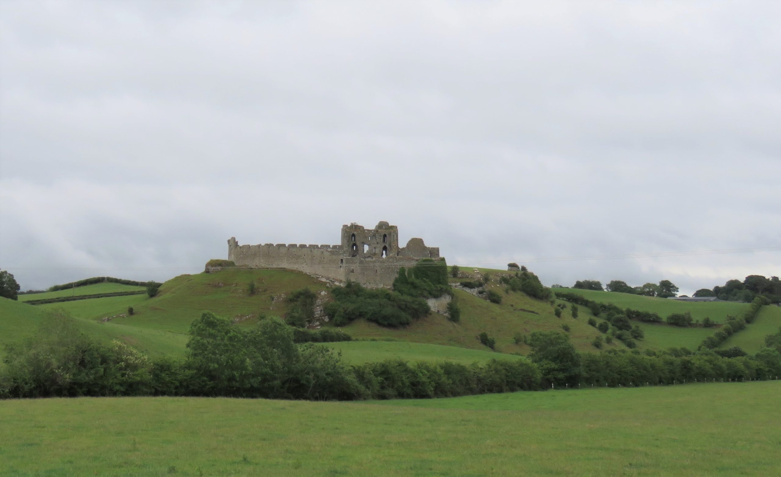
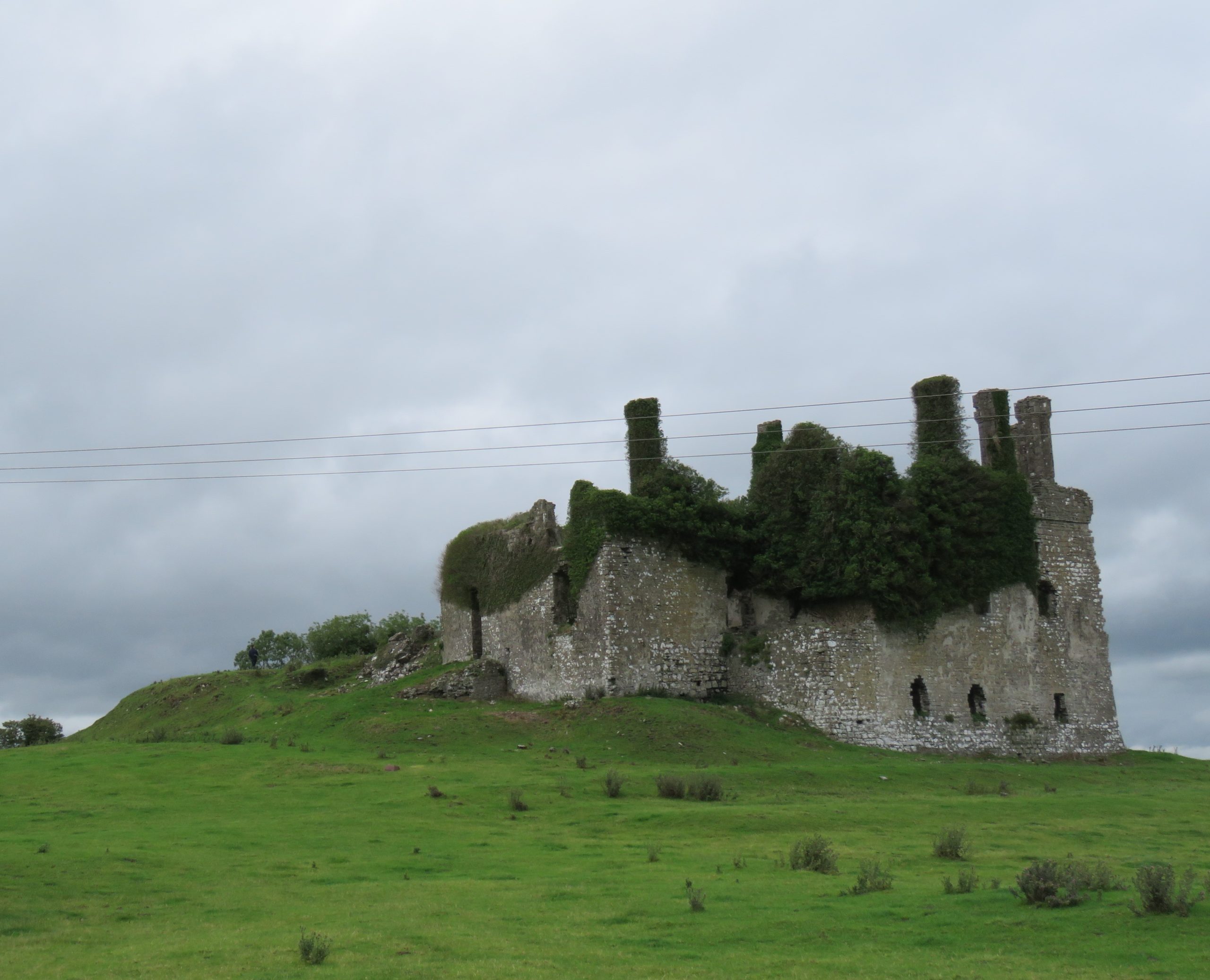
Figure 2 Castleroche, Co. Louth, sited for maximum spectacle across a locally significant elevation at the foothills of the Mourne Mountains
Relict Plants in their Castle Contexts
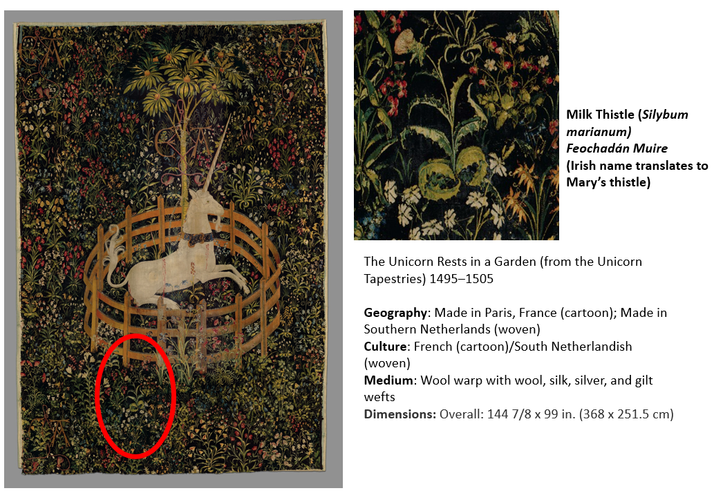
Castleroche was the first site surveyed for our fieldwork. It is spectacularly situated on a locally significant rocky outcrop, framed to the north by the foothills of the Mourne Mountains (Fig 2). The castle has been long understood as a defensive site, believed to have been positioned as authoritative infrastructure to exercise territorial control. Its’ patron, Roesia de Verdun (d.1247) is renowned as the only historically attested woman to have founded a castle in thirteenth-century Ireland This castle while now in ruins was once a busy place with an associated village replete with a weekly market and annual fair. I considered this site to have great potential for relict plants given that historic sources noted the presence of ‘gardinia’ (gardens associated with castles) coupled with the high-status of its’ patron who had a considerable number of estates across England and France. These connections must have given her and her staff access to, and knowledge of, different cultural traditions including gardening and medicinal practices. We were delighted to identify three archaeophytes: Hemlock (Conium maculatum), Mallow (Malva sylvestris) and Milk thistle (Silybum marianum). Milk thistle is a particularly important identification, it is very rare in Ireland and Britain. For medieval people, it was culturally and symbolically tied to the Virgin Mary as well as understandings of fertility and motherhood (Fig 3). This allows us to reconsider the idea of Castleroche only as a frontier site; perhaps there was a diverse resident population for much longer than previously understood. Their health concerns may be represented by the continued occurrence of these plants. Exploring the botanical legacy of Castleroche adds further layers to the story of this complex site.
Figure 3 The Unicorn Rests in a Garden (from the Unicorn Tapestries) 1495–1505. https://www.metmuseum.org/art/collection/search/70007568Figure 4 Carbury, Co. Kildare: a multiperiod castle complex comprises a motte, an early masonry focal building with later additions including an Elizabethan extension crowned with multisided cut stone chimneys
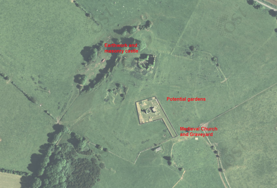
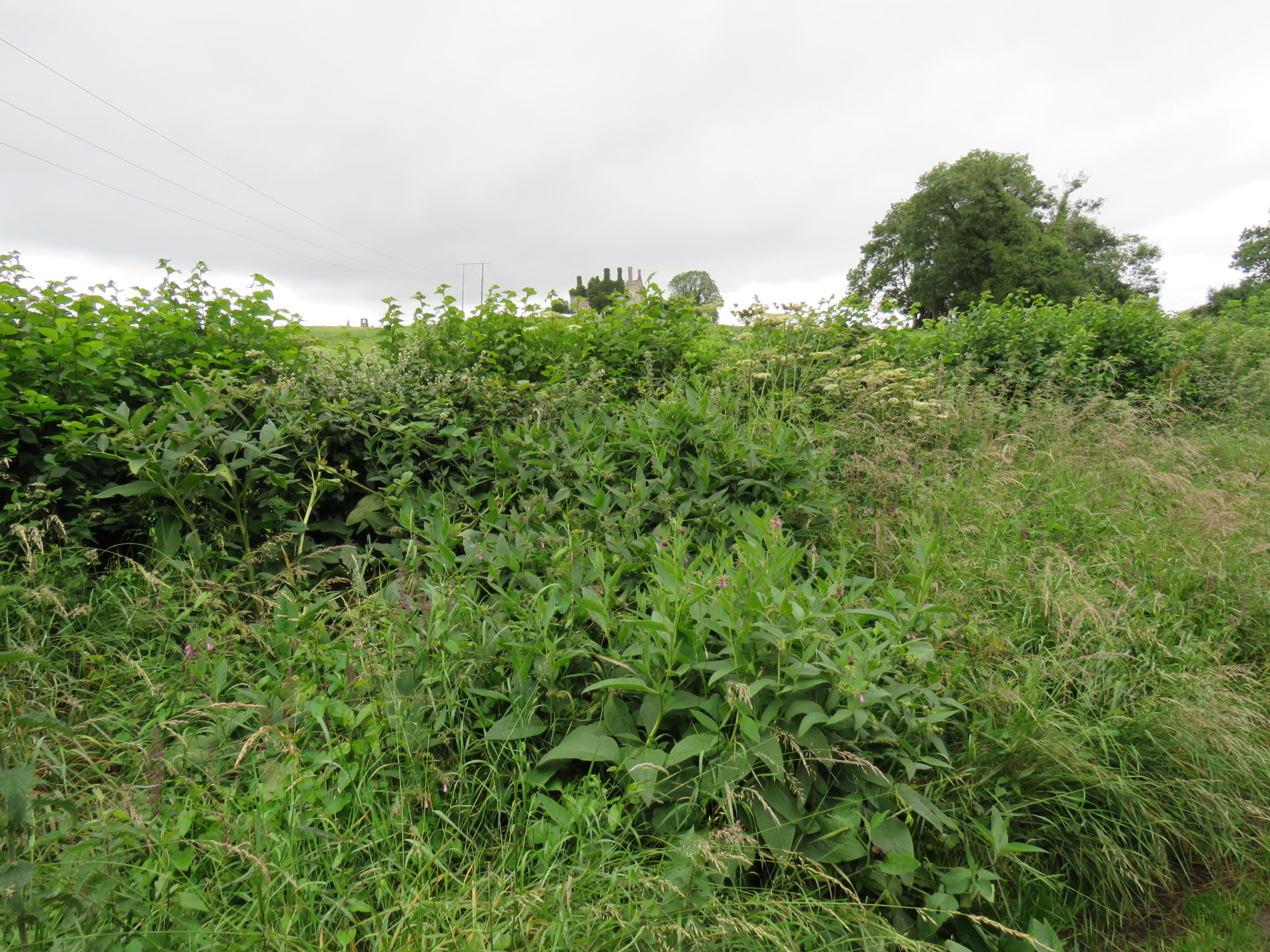
A less well-known castle but equally deserving of attention is the medieval settlement at Carbury (Fig 4). This multiperiod complex comprises an earthwork castle, a twelfth or very early thirteenth-century masonry castle with later additions including an Elizabethan extension and related gardens (Fig 5). Carbury is entangled with generations of nobles. It acted as a central node in shifting political allegiances and dynastic disputes within the territory of Leinster. The longevity in occupation of Carbury is interesting, it attests – at least in part – to its suitability as a residence. Is this reflected in the immediate castle landscape? Is there a possibility that the early-modern gardens here overlay medieval predecessors? Four archaeophytes were found at Carbury: Hemlock, Comfrey (Symphytum officinale), Hedge mustard (Sisymbrium officinale) and White stonecrop (Sedum album), three of which were adjacent to or within the masonry castle and the fourth – Comfrey – which was found within the hedgerow that forms the historically significant boundary to the castle landscape (Fig 6). These plants are not uncommon, but perhaps their relative ubiquity is reflected in their suitability for use within different plant medicine traditions. Comfrey is particularly notable, known as knitbone, it was widely used as a healing poultice for broken bones throughout medieval medical texts. Pharmacologically, this plant contains allantoin, which promotes the creation of new cells and healing of connective tissue. Relict plant studies at Carbury allows us to reflect on how this place was a home to many different generations of people who participated in caring roles (for plants and people) whilst also being a locus for political tensions.
Figure 5 Aerial Imaging of Carbury Castle with evidence for potential gardens surrounding the castle.Figure 6 Comfrey (Symphytum officinale) and Hedge woundwort (Stachys sylvatica) noted among other medicinal plants in hedgerow with Carbury Castle in background
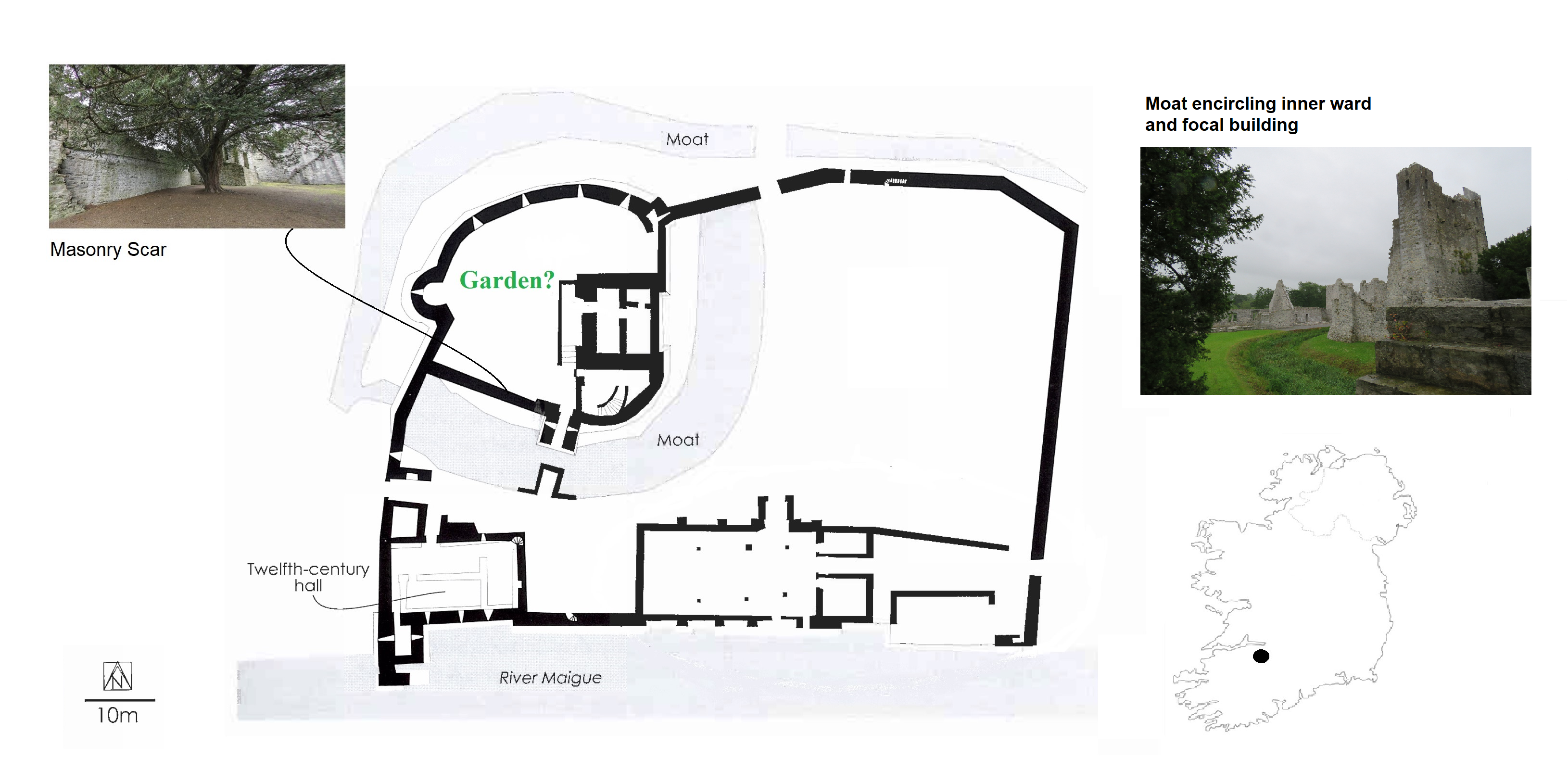
With these exciting discoveries at both Castleroche and Carbury, we were very hopeful that the survey at Adare Castle would be equally rewarding. Adare was an important castle as the caput of the Geraldine family. Unlike the other sites, it has been subject to major study including detailed historical and archaeological investigation. Adare Castle was constructed on a pre-Norman power centre from which the castle emerged as a large D-shaped earthwork with a surrounding large ditch and river-fed moat (Fig 7). This later formed the inner ward, which was further enclosed by an external wall to the north-west with a single mural tower and a gatehouse to the south. The outer court is enclosed by masonry walling which is augmented by a ditch to the north and west. At Adare, the grounds are intensely managed, with manicured lawns and ongoing pesticide use (Fig 8). Unfortunately, this was particularly pronounced in the inner ward, the area I have suggested was likely to have contained an enclosed garden. Disappointingly, only one archaeophyte was identified: Weld (Reseda luteola). This dyeplant was predominantly used to give a bright colourfast yellow but also used medicinally to treat chest complaints. A number of neophytes – those plants whose introduction post-dates 1500 CE – were found in the associated areas surrounding the castle as detailed by Dr MacGowan. Species such as Himalayan pheasant berry (Leycesteria formosa) were identified, indicating that relict plants studies can also illuminate the afterlife of the castle when it played a role as a romantic ruin in the eighteenth-century landscape of Adare Manor. This shows the potential for relict plants studies to add layers to castles stories across their life histories.
Figure 7 Plan of Adare Castle with possible garden (after Dempsey 2021 and O’Keeffe 2015)Figure 8 Adare Castle, inner ward subject to extensive pesticide use
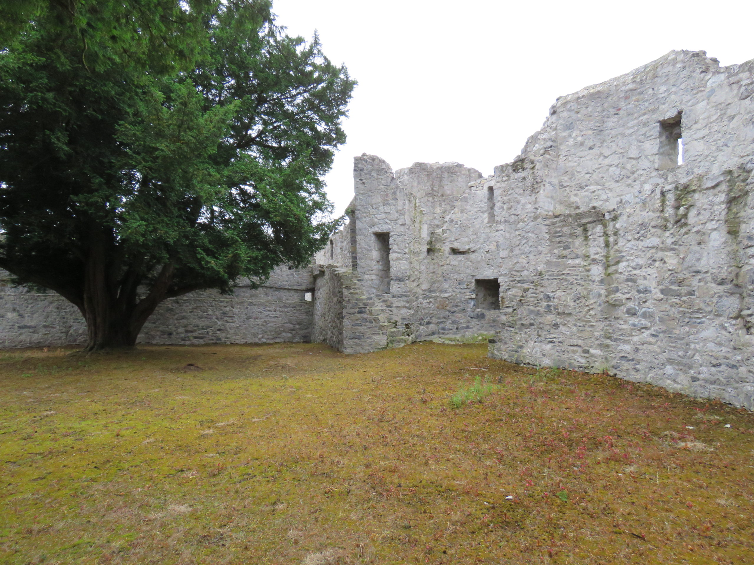
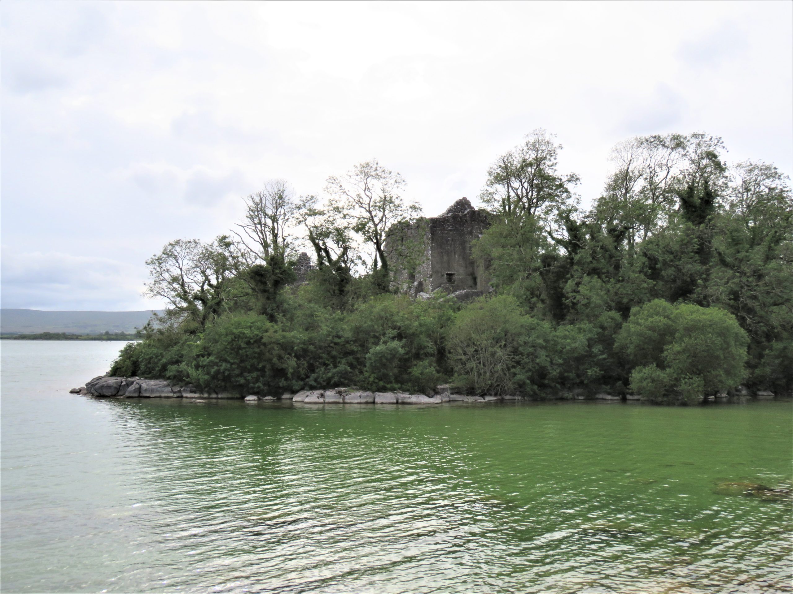
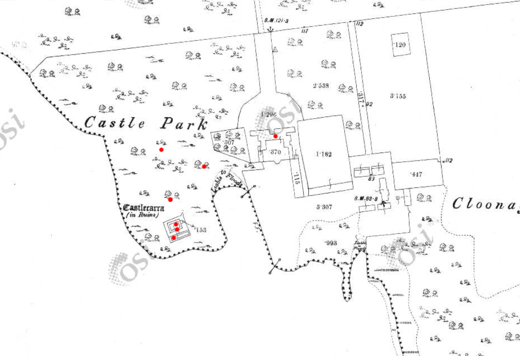
The final site, Castlecarra, falls lower down the social hierarchy of medieval Ireland than the other three castles but it was still an important baronial residence (Fig 9). It is situated on the eastern shore of Lough Carra. The castle now comprises a large three-storey focal building set within a very compact enclosure which is a later, potentially fifteenth-century addition. The castle was constructed as one part of the c. 1236 Anglo-Norman territorial expansion into Connacht. This site, like the others, has a long history of occupation. An early-modern (sixteenth-century?) house was constructed c. 125m NE of the castle, and the surrounding landscape appears to have been remodelled to suit a new tradition of landscape gardening which included a ha-ha and tree-lined avenue of Hornbeams (Carpinus betulus) (Fig 10). Archaeophytes were not recorded at Castlecarra but numerous native species as well as neophytes were present. This absence is remarkable but perhaps native plants at Castlecarra served the castle household needs. For example, Purging buckthorn (Rhamnus catharticus) was identified. This plant is native but rare in Ireland, and it was used medicinally as a purgative, as the name suggests. The botanical profile of Castlecarra leads to further questions around the transmission and sharing of medicinal and plant knowledge.
Figure 9: Castlecarra, Co. Mayo on shore of Lough CarraFigure 10 Castlecarra, Co. Mayo: a multiperiod site with medieval castle that forms part of the landscape of an early modern (c. later 16th / early 17th house). Ordnance Survey Map 1925, Castlecarra to lower left and historic home including outbuildings and gardens centrally placed. https://maps.archaeology.ie/HistoricEnvironment/
Research, Heritage Futures and Reflection
One of this project’s aims was to test and refine the methodologies of relict plant studies for medieval castles. In Ireland there are currently 96 species recorded as archaeophytes (but with no established dates of introduction). Despite the findings of some notable plants, the overall numbers of archaeophytes at the castle sites in ‘Sowing Seeds’ seemed low. Of course, our findings may have been constrained by single survey days, unseasonal weather as well as conservation and management issues – both present-day and historic. Future work is necessary. It is important that sites have the benefit of multiple visits across a wider seasonal survey period. Nevertheless, the baseline botanical surveys of this project will be of use for future research within and outside of castle studies. It has also revealed the need for a detailed survey of archaeobotanical evidence from excavations in Ireland to establish as far as possible exact introduction dates for particular plants.
Including a wider range of plants and castles over a longer time span would provide comparative material with a greater capacity to capture change over time. Neophytes were noted in the botanical surveys but not part of the research agenda for ‘Sowing Seeds’. Their occurrence at castle sites may be revealing of expanding connections with sixteenth-century colonising and trading practices beyond Europe. Later medieval towerhouses are of particular interest as they are often situated within less managed and therefore within potentially better-preserved landscapes. But equally, native plants should also be included. For example, self-heal (prunella vulgaris) and pellitory-of-the-wall (Parietaria judaica) occur widely and were both used as medicinally. It would be of great interest to compare and contrast different plants at castles whether native, anciently introduced or more recent. Consideration too could be given to the afterlives of medieval castles as romantic ruins as indicated at Castlecarra and Adare. This would develop a wider appreciation of the long lives of medieval castles that continue in dialogue with contemporary communities as heritage today. Relict plant studies enable castle studies to participate in emerging conversation around green heritage and climate change.
‘Sowing Seeds’ was a novel project – both conceptually and methodologically – I wanted to find a way to explore potential ‘green identities’ of castle households. Accessing the relationships medieval people may have had with their environments (as we might term it today) offers a different way of telling stories about the medieval past whose narratives are often caught into concerns of power, authority or control. By including botanical surveys of relict plants in castle landscapes, we have expanded further the multidisciplinary approach of castles studies. We can show how stories of castles are richly textured: populated by many people and plants over the course of their lives and beyond into their afterlives as romantic ruins and archaeological monuments. Doing this for the first time meant engaging with new material and unfamiliar sources from archaeology, history, and medical knowledge to heritage and folklore. This wide-reaching research methodology is a core strength of this project. It enables a dialogue between different disciplines that are traditionally separate or rarely integrated. These findings are a beginning: they encourage new avenues of future research on castles households relating to human-plant relations, plant medicine and related concepts of care. The results also invite conversations with heritage agencies regarding site management and conservation practices of both biodiversity and past vegetation. Rather than offering conclusive findings, we have revealed tantalising hints and a vast array of potential new avenues in which to take this research.
This research was generously funded by the Castle Studies Trust. Their support enabled new ideas to be explored. As an early career researcher being awarded a grant to undertake (potentially) interpretatively risky work is a wonderful opportunity.
Helpful commentary and feedback was received from two assessors whose insights improved this report.
Thanks to Dr Fiona MacGowan for participating in this research project and carrying-out the botanical surveys at the selected sites.
Thanks to the landowners of Castleroche, Castlecarra and Carbury, and the Office of Public Work who manage Adare, for access to the sites for this project.
[1] Dates in the table refer to the first historic botanical record of these plants in Ireland and Britain, and * denotes their occurrence in lists of species included in medieval gardens (Harvey 1981)
Dr Will Wyeth, English Heritage property historian and project lead on the two geophysical surveys the Castle Studies Trust funded on Warkworth Castle, looks at what the surveys reveal and equally importantly don’t reveal about the castle.
The results from two geophysical surveys in and around Warkworth Castle have now been digested and synthesized. The first survey sought to explore evidence for subsurface remains of the castle earthworks. The second survey examined a field called St John’s Close, sited within a corner of the medieval park attached to Warkworth Castle. Both surveys are intended to inform English Heritage’s on-going project to improve the way the history at the castle is explored and shared with visitors. Here, we share some of the highlights of these surveys: for the full discussion of the results, you can read the full report here.
The first survey targeted three areas of the castle. The first was the top of the earthen mound, or motte (see a phased site plan here). Our aim here was to establish the presence or any subsurface features which may relate to any structures pre-dating the present late 14th-century Great Tower (Figure 1). Our results here were inconclusive: the subsurface examination certainly revealed a feature, perhaps a drain or path, associated with the postern of the present Great Tower (Figure 2). Other features may represent building or demolition rubble, but it’s not clear which.
The second area of the castle earthworks to be examined was a portion of the castle’s raised bailey platform, east of the enclosing curtain wall presently dated to the late 12th-early 13th centuries. The earthworks of the bailey of Warkworth Castle pre-date any stone buildings known to survive at the present castle: this is because the earliest structures – among them the curtain wall – do not embrace the entirety of the earthworks (see a phased site plan here).
Our research question here was to establish why this eastern portion of the bailey was left unenclosed, upon the construction of the enclosing curtain wall. Here, again, our results were inconclusive with regards our research question, though the survey did throw some light on possible uses of this space in the later medieval-early modern period. The survey detected a trampled path from the area east of the eastern curtain postern, south of the 15th-century stable building, heading northwards, respecting the projecting mass of the 1290s Grey Mare’s Tail Tower (see feature 14, Figure 4 ). The relative phasing of this feature does not tell us a great deal, except that the path may post-date the construction of the Grey Mare’s Tail Tower. It may also suggest that the postern in the curtain wall, currently dated to the late 14th century, could be coeval with the Grey Mare’s Tail Tower, or it may have replaced an earlier iteration. This is the earliest possible arrangement, as the path could also be more recent in date.
The final portion of the castle earthwork survey sought to establish the location and extent of features within the enclosed portion of the bailey (‘Area 1’, see Figure 4). Uncertainty remains as to the configuration of the bailey before a major phase of construction presently dated to the 15th century. This substantial campaign of building incorporated the construction of the compressed collegiate church (perhaps never completed) with exquisite covered passage, and a comprehensive rebuilding of the eastern portions of the Great Hall, Chamber block and chapel in the bailey, of which the finest surviving portions are the Lion’s Tower and the Little Stair Tower (Figure 5).
The most substantial, and perhaps important, finding of the geophysical survey of the earthworks relates to feature 2 (see Figure 4). Located in the south-eastern quarter of the bailey, it comprises a substantial segment of buried wall or robbed wall foundations, approximately 22m long (on an east-west axis) and c.2m thick. Though the feature stops short of the bailey curtain wall here, it clearly blocks the east curtain postern already mentioned, and therefore may very well pre-date it. The massive character of this feature suggests it may have belonged to a substantial, multi-storey building. Feature 2 also appears to meet the curtain wall at a right angle, with one possible implication being that it may have formed one wall of a square- or rectangular-plan building, which was demolished to make way for the present curtain wall. Curiously, although the castle is not very extensive, the concentration of known high-status buildings from the later 12th-century onwards is on the bailey’s western side. If feature 2 relates to a high-status building, it is unusual for being located in the eastern part of the bailey. Several other features were located within the bailey; these are discussed in the full report.
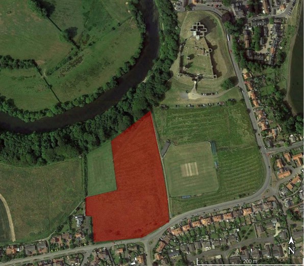
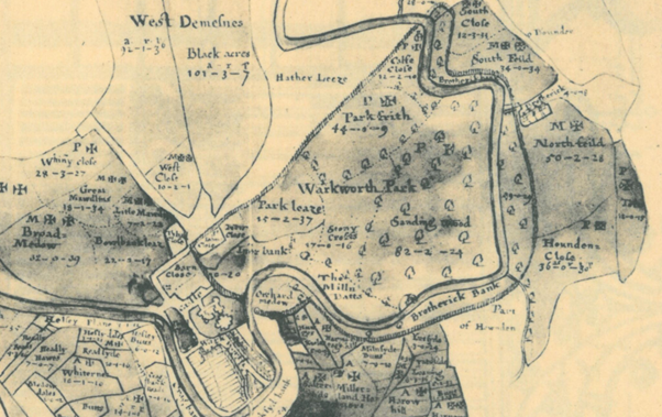
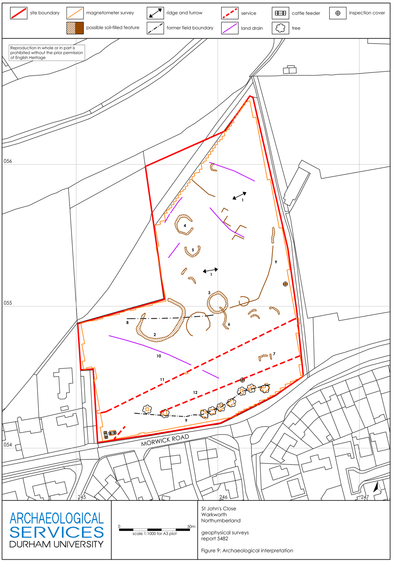
The second area examined by geophysical survey comprised part of the park of Warkworth Castle. The earliest record of the park is dated to the 13th century, but a park at Warkworth may have existed earlier still. Hogdson’s History of Northumberland, which assembled extensive records from the Alnwick Castle archives and elsewhere, offers a rich picture of the late medieval administration of the park, with records of repairs, infringements, agistments (a one off payment by a livestock owner to graze on the land of the landowner) and the collection and sale of underwood all recorded in 15th-century documents. The earthworks of the castle park have yet to be comprehensively mapped, but a portion of the south-east corner of the park, fossilizing the boundary of an historic field within the park called St John’s Close, does survive (see the previous Warkworth blog post for photos of these). This field was chosen as the target of geophysical survey to determine the survival of any features or buildings associated with the medieval park. Research on castle parks has demonstrated that they could feature a broad variety of structures, and were not simply enclosed areas. A further research goal was to ascertain the precise location of a documented park gate attested in a 17th-century estate map (Figure 7), which could represent the closest point of access into the park enclosure from Warkworth Castle.
Figure 7. Estate map of the 1620s, depicting Warkworth Castle (lower left), village and park boundary. The postulated park gate is the round-headed opening roughly half-way along the park’s eastern boundary, between the castle and St John’s Close. Top is south. From Hodgson’s A History of Northumberland, V, opposite p.136 (archive.org. link here).
Unfortunately, the survey results did not yield answers to the questions we posed regarding any medieval features within the area of parkland surveyed, nor was it possible to decisively establish the location of a park gate. The most significant find was in the form of several round features, either enclosures and/or hut circles, which are very likely prehistoric in date (Figure 8). A walk-over of this area confirmed that they were not visible at ground surface level, being concealed by ridge-and-furrow deemed to be medieval in date. The largest of these, feature 2, is also bisected by a former field boundary depicted on the early 17th-century estate map mentioned earlier, though not shown on either of the 1st edition OS maps. A possible caveat to the lack of medieval finds is feature 9 (see Figure 8); this could be a path or hollow-way, and it appears to cut (and therefore post-dates) the ridge-and-furrow. As the eastern terminus of feature 9 is close to the edge of the park boundary, it may point to the location of the suspected park gate. Its western extent appears to respect the trajectory of the lost field boundary, and there it may represent an early modern, post-medieval feature. For a fuller account of the features revealed by the survey, see the full report.
Although neither survey succeeded in yielding clear evidence to help answer all the research questions we asked at the beginning, they certainly improved our understanding of both areas examined. In the case of the castle earthworks, it is clear that a substantial building once occupied the south-eastern portion of the bailey, and it is now possible to map this accurately in relation to surface-level features. In the case of the park, we can tentatively identify the approximate location of a gate into the park, though we cannot be certain it is medieval in origin. More work may allow us to ascribe dates, or relative phases, to these features.
For English Heritage’s interpretation project at Warkworth Castle, these surveys have been invaluable, and we are grateful for the support of the Castle Studies Trust in pursuing them – especially during the difficulties in completing the surveys resulting from the Covid-19 pandemic. Going forward, the standing buildings of the castle have also been subjected to a separate, detailed analysis, and it is hoped that the bringing together of these two sets of data will offer a fresh understanding the site. Although the research is ongoing, a preliminary integration of both appears offers some new and tantalising ideas about the history of Warkworth Castle. These will inform our presentation of Warkworth Castle to the public, and improve our collective understanding of one of England’s finest castles.
In September 2021, Dr Coralie Mills and Hamish Darrah from Dendrochronicle along with a team from Historic Envirnoment Scotland led by Rachel Pickering removed an original timber from the Great Tower at Old Wick in Caithness to help date the castle.
Following on from the successful removal of the piece of wood Dr Coralie Mills and her colleague Hamish Darrah have taken the wood back to their lab for further analysis. In three short videos they explain what they have been doing and what they have found.
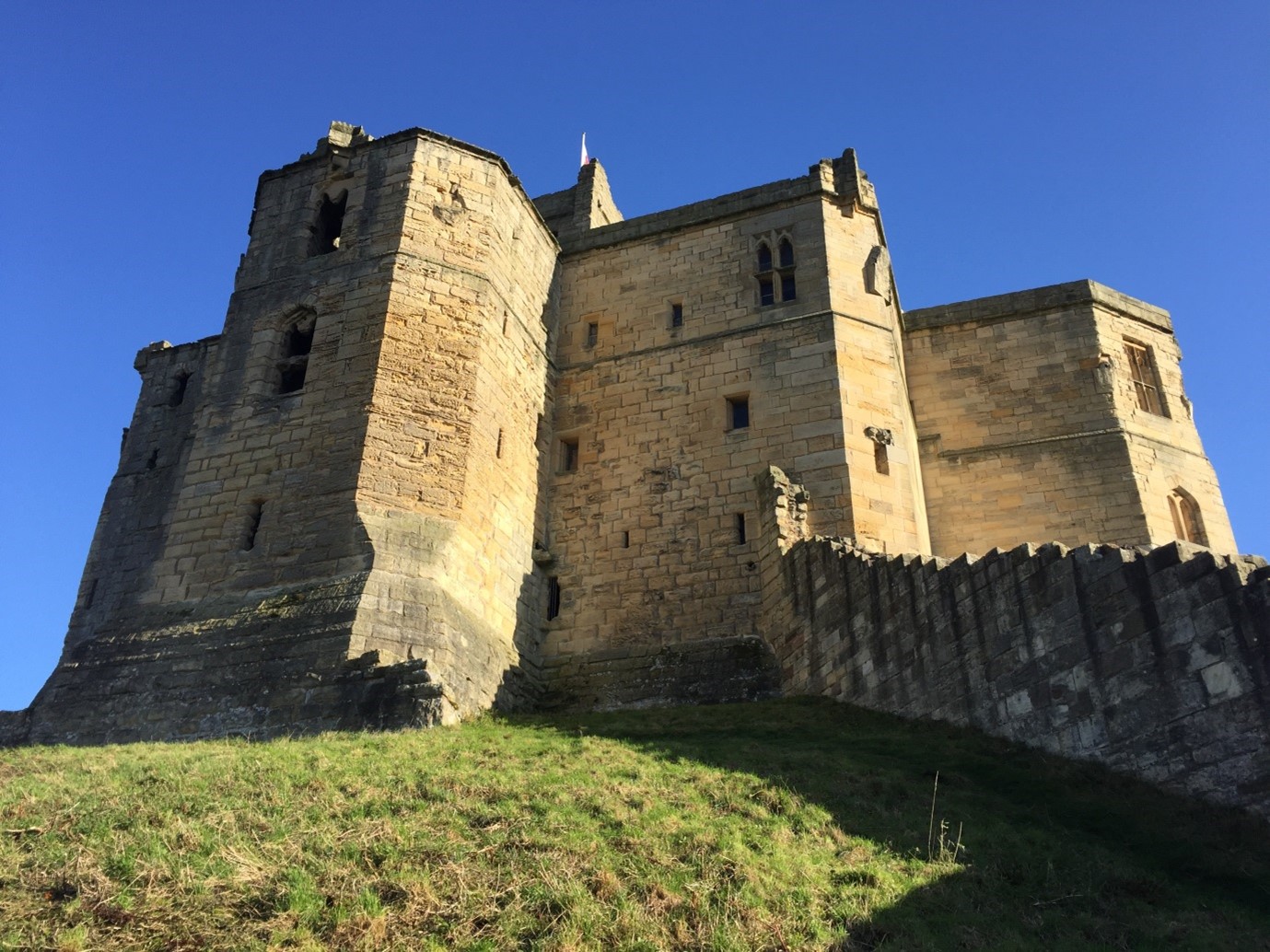
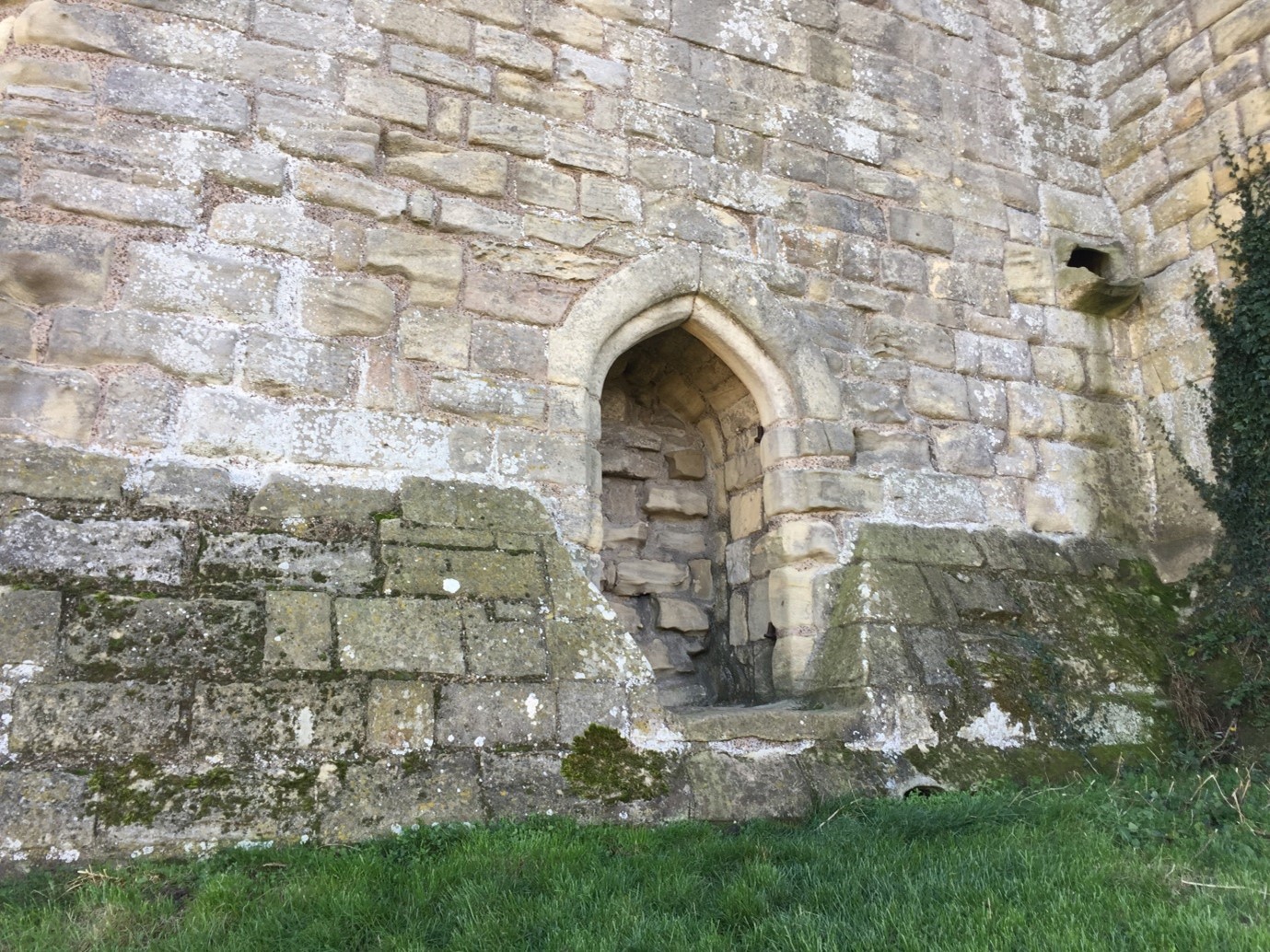
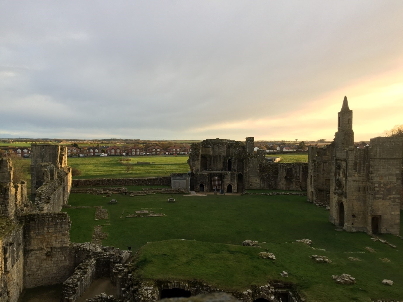
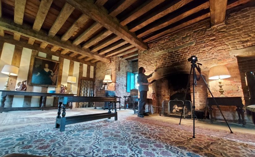
James Wright FSA, buildings archaeologist and project lead on our Greasley building survey project takes a look at how buildings archaeology can help us understand castles.
The study of mediaeval castles, palaces or great houses and the discipline of buildings archaeology have closely related histories. The Castle Studies Trust has asked me, as a buildings archaeologist with a long-established research interest in such structures, to write a blog outlining these relationships.
Buildings archaeology has been defined as: ‘the study of buildings as archaeological objects in their own right… the development of structure… fabric, form and function’ (Morris 2000, 14). Ultimately, the subject demands the forensic methods associated with the careful unpicking of stratigraphy in below-ground archaeological excavation but applies those techniques to standing buildings.
Survey work at Holme Pierrepont Hall (Picture: James Wright / Triskele Heritage)
Early Castle Studies: Military Historians
Although some antiquarians had demonstrated an interest in the structures of castles, most early castle specialists approached the subject from the archives. Scholars such as G. T. Clark (1884) and Alexander Thompson (1912) were concerned with documented building phases, ownership of castles and events which took place within their walls. Both authors were also very concerned with military matters and, for them, the castle was primarily a defensive fortification.
The military focus dominated castle studies for around a century. Philip Warner (1973, 8), a senior lecturer at the Royal Military Academy, summed this up when he stated the principal purpose of a castle was: ‘for delaying and dislocating an invading army.’ David Stocker (1992, 415-20) has pointed out that the prevailing notion that castles were primarily fortifications was perhaps due to so many castle scholars having seen military service.
Alternative perspectives can be traced back as far as Ella Armitage (1912, 8) who acknowledged the military uses of castles, but also emphasised their important domestic aspects as: ‘private fortified residences of great landowners’. This balance of military and residence can then be felt in the writings of Reginald Brown (1954), Colin Platt (1982) and Norman Pounds (1990).
Throughout much of the twentieth century the study of castles tended towards a sharp division of labour between historians and archaeologists who rarely collaborated. When the two disciplines were brought together the results were generally much improved – as happened with Howard Colvin and Philip Rahtz’s work on the royal palace at King’s Clipstone (Rahtz & Colvin 1960, 21-43). However, it was still the case that Colvin looked in the archives whilst Rahtz wielded his trowel and the standing architecture was largely overlooked.
Modern Castle Studies: A Holistic Approach
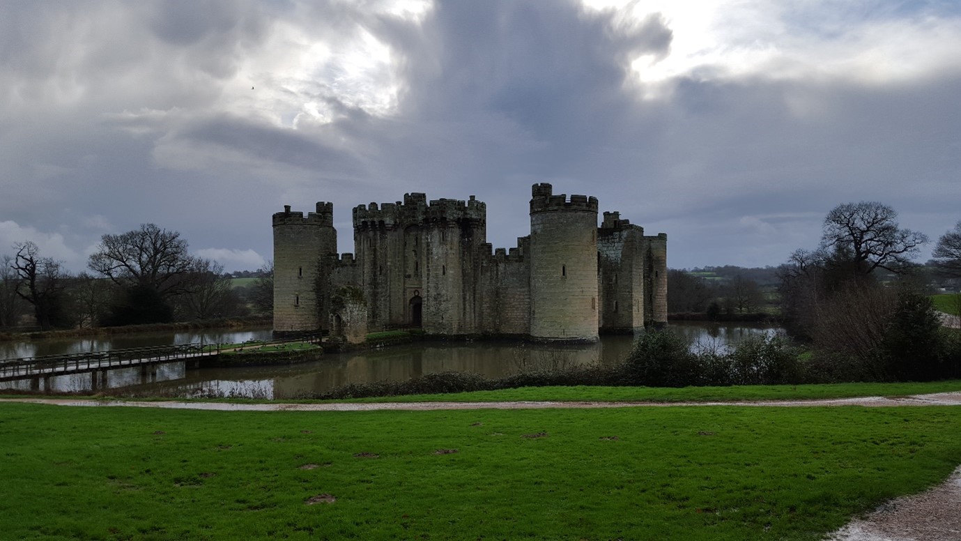
Subsequently, an emerging generation of researchers sought a more holistic approach which skilfully entwined archival sources, archaeological excavation, art and architectural history, landscape studies and the physical examination of standing buildings. Important re-assessments of sites, such as Bodiam Castle, placed emphasis on the symbolic and prestigious aspects of castles rather than the military versus residential debate (Coulson 1992; Everson 1996).
Bodiam Castle (Picture: James Wright / Triskele Heritage)
Buildings archaeology helped to revolutionise approaches to interpreting castles through the work of scholars, such as Philip Dixon and Pamela Marshall, who engaged with high quality, site-specific studies including Knaresborough Castle (Dixon 1990), Hedingham Castle (Dixon & Marshall 1993) and Newark Castle (Marshall 1998). Such work helped to build up a strong body of published fieldwork that chimed with a newly complex view of castles. Such projects placed castles in their contemporary moment as a mechanism for understanding the mediaeval lived experience.
With castle studies no longer shackled to rigid debates, the discipline was truly able to take wing. Oliver Creighton (2002, 2009) developed research into castle landscapes, Matthew Johnson (2002) took a strong theoretical approach and Robert Liddiard (2005) offered the wider context into which castle studies could be framed. Meanwhile, the multi-disciplinary investigation of individual buildings such as the Tower of London (Impey 2008), Knole (Cohen & Parton 2019) and Oxford Castle (Munby et al 2019) have remained central.
Knole (Picture: James Wright / Triskele Heritage)
Investigating Castles
When approaching a new site, such as the recent survey of the late mediaeval courtyard house at Holme Pierrepont, I first like to walk around the entire building with the landowner or curator. This recce is one of the most important moments, as the site is gradually revealed, and I can listen to my companion’s impressions of a structure that they know intimately. However, it is important to maintain a level of detachment – misidentifications, mistakes and myths can creep into the dialogue. This is why I also have a preference for not doing a deep dive into the documents prior to visiting a castle. I find it useful to let the structure “speak” without what can often be conflicting archival sources distracting me.
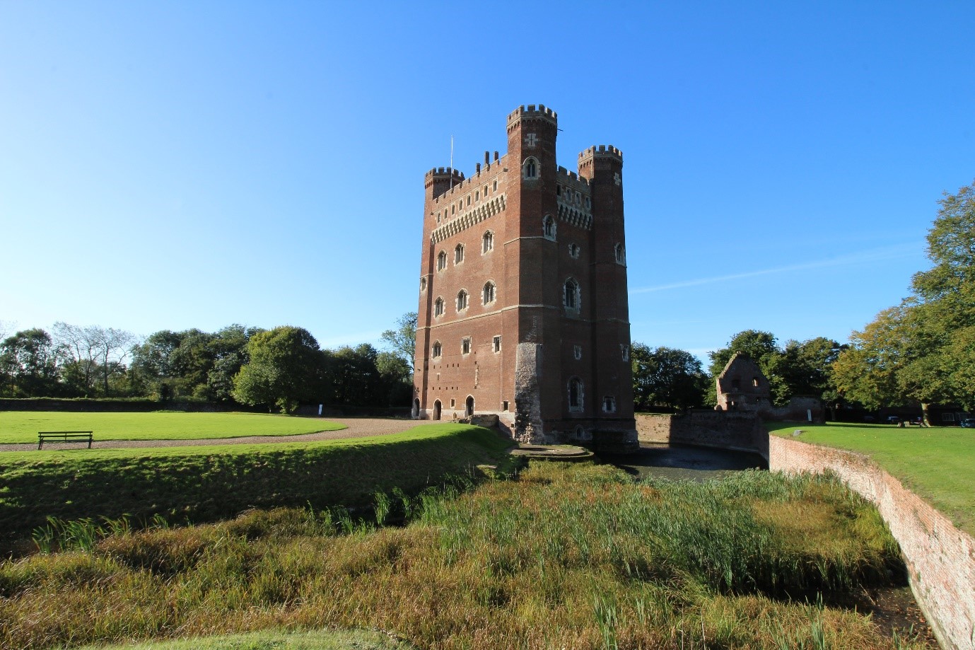
Then the real work begins! It is important to approach the survey methodically. When working at Tattershall Castle, I concentrated on the structures of each enclosure separately: starting with the gatehouse to the Outer Ward and gradually working my way, structure by structure, into the heart of the castle. This technique allowed a detailed progression of land-use to emerge in a sequence that would be recognisable to the lived experience of a mediaeval visitor to the castle. The last building that I tackled was the great tower – the most significant, complex and private space of the castle (Wright 2021).
Tattershall Castle (Picture: James Wright / Triskele Heritage)
Although we can employ many pieces of equipment – digital cameras, drones, total stations, laser scanners and sampling for dendrochronology (all very useful for data gathering) – the most essential gear on site are the eyes and experience of the buildings archaeologist. Trained observation and interpretation are key. Therefore, my first task at sites, such as Greasley Castle, will be to either create measured drawings – floor plans, elevations and sectional-elevations – of the building or to check, add to and annotate pre-existing surveys. Quantifying what is actually present on site underpins analysis. We can also create new data by producing measured sketches or scaled drawings of features such as roof structures and areas of the building which are difficult to photograph due to spatial constraints.
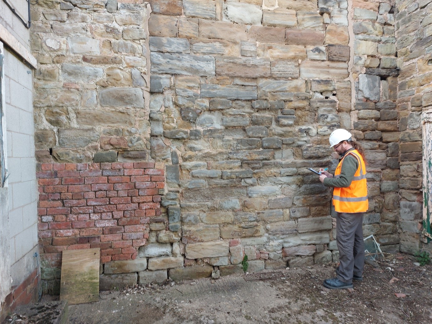
Observations on site might include noting the stratigraphical relationships between different phases of structures – a mediaeval window blocked in the post-medaeval period at Greasley Castle, the fifteenth century great tower at Tattershall Castle which abuts a thirteenth century mural tower (Wright 2021), or evidence for the wholesale reorganisation of roof structures at Knole (Sorapure & Wright 2013, 263-70). Depth is given to the survey by noting the stylistic typologies of particular structures – a Norman doorway at Kings Clipstone, thirteenth century window tracery at the Palace of Westminster or a late mediaeval chimneypiece at Nottingham Castle (Wright 2016, 34-37; Wright 2014; Wright 2017a, 19-23). Recording details such as mason’s marks, carpenter’s assembly marks and historic graffiti at Knole and Home Pierrepont Hall added to the understanding of the human agency behind the construction and occupation of the buildings (Sorapure & Wright 2013-14, 263-70).
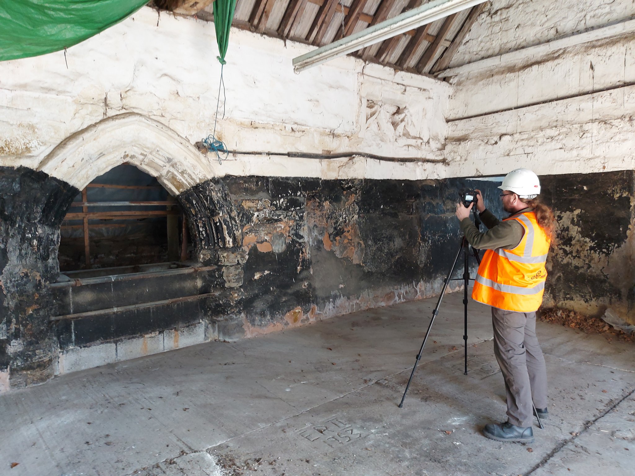
Survey work at Greasley Castle (Picture: James Wright / Triskele Heritage)
Each space will be recorded systematically – usually (but not exclusively) starting at the bottom and working upwards, before looking at the exteriors. When all of the areas of the building have been drawn and annotated, it is time to move on to a comprehensive photographic survey, including both general and detailed shots. It is particularly important to capture all of the relevant data, whilst still on site to refer back to during the write up.
A standing building report will usually comprise two principal elements. Firstly, comes the historical background which establishes the known history of the structure based on a trawl of archival and published sources. At Tattershall Castle these included the 1231 licence to crenellate, building accounts from the 1430s and 40s, biographical data on its patron Ralph Lord Cromwell, parliamentary records of the slighting in 1650, antiquarian images showing its visual appearance in the eighteenth and nineteenth centuries and the letters and papers of Lord Curzon which related to the castle’s conservation in the 1910s (Wright 2021; Wright 2020). It is crucuial to tell the whole story of the castle from its inception right up to the modern day. Secondly, the archaeological analysis of the structure will link back to historical events which may have led to alteration of the structure of the castle. This analysis is typically ordered either chronologically or by physical space, sometimes a mixture of both. The text will be liberally illustrated with photographs, historic images and measured drawings.
There are many ways in which buildings archaeology can be reported. These include site reports, published articles, books, websites, blogs, social media posts, press reports, guidebooks, on-site interpretation, mobile apps, film-making and interpretation panels. A mixture of platforms has become the norm, but reporting is literally the most important part of any archaeological project. There is simply no point doing the fieldwork if you don’t tell other people what you have found!
Surveying at Greasley Castle (Picture: James Wright / Triskele Heritage)
Conclusions
The incorporation of modern buildings archaeology into castle studies helped to fill a fundamental gap left by projects that had previously concentrated on archival research or archaeological excavation. By taking a detailed approach to the analysis of standing structures, alongside other data streams, the scholarship was able to move on to vital new interpretations.
In my own work on castles, I have been able to apply buildings archaeology techniques to better understand the form, function, building materials, phasing, development and histories of entire sites such as Tattershall Castle or Kings Clipstone Palace (Wright 2021; Wright 2016). It has also led to significant discoveries, such as the identification of Edward IV’s personal livery badge on a chimneypiece at Nottingham Castle or graffiti connected to the Gunpowder Plot at Knole (Wright 2017a, 19-29; Wright 2017b, 78-80). Meanwhile, on my most recent sites, at Holme Pierrepont Hall and Greasley Castle, we are helping to provide an understanding of the archaeological phasing of structures which have previously eluded specialist attention.
Elements of this blog have been remodelled from Wright, J., 2021, ‘Background to English Castle Studies’ in Tattershall Castle: Building a History. Unpublished PhD thesis. University of Nottingham.
About the author
James Wright of Triskele Heritage is an award-winning buildings archaeologist. He has a long-lived research interest in mediaeval castles, palaces and great houses. He has worked on surveys of buildings including the Tower of London, Nottingham Castle, Knole, Holme Pierrepont Hall and the Palace of Westminster. He has written books on Tattershall Castle, Kings Clipstone Palace and the castles of Nottinghamshire. He is currently engaged in a building survey, funded by the Castle Studies Trust, at Greasley Castle.
Featured image: Buildings archaeology survey at Holme Pierrepont Hall (Picture: James Wright / Triskele Heritage)
References
Armitage, E., 1912, The Early Norman Castles of the British Isles. John Murray. London.
Brown, R. A., 1954, English Medieval Castles. Batsford. London.
Clark, G. T., 1884, Medieval Military Architecture in England Vol. 1 & 2. Wyman & Sons. London.
Cohen, N. & Parton, F., 2019, Knole Revealed. National Trust. Swindon.
Coulson, C., 1992, ‘Some Analysis of Bodiam Castle, East Sussex’ in Harper-Bill, C. & Harvey, R. (ed.s), Medieval Knighthood Volume 4. Boydell Press. Woodbridge.
Creighton, O., 2009 (2013 edition), Designs Upon the Land – Elite Landscapes of the Middle Ages. Boydell & Brewer. Woodbridge.
Creighton, O., 2002, Castles and Landscapes. Equinox. Sheffield.
Dixon, P., 1990, ‘The Donjon of Knaresborough: the Castle as Theatre’ in Château Gaillard Vol. 14. Publications du CRAHM.
Dixon, P. & Marshall, P., 1993, ‘The great tower at Hedingham Castle: a reassessment’ in Fortress Volume 18. Beaufort Publishing. Liphook.
Everson, P., 1996, ‘Bodiam Castle, East Sussex: Castle and its Designed Landscape’ in Château Gaillard Volume 17. Publications du CRAHM.
Impey, E. (ed.), 2008, The White Tower. Yale University Press. New Haven and London.
Johnson, M., 2002, Behind the Castle Gate. Routledge. London.
Liddiard, R., 2005, Castles in Context. Windgatherer Press. Macclesfield.
Marshall, P., 1998, ‘The Twelfth-Century Castle at Newark’ in Alexander, J. (ed.), Southwell and Nottinghamshire: Medieval Art, Architecture and Industry. British Archaeological Association Conference Transactions Volume 21. British Archaeological Association. London.
Morris, R. K., 2000, The Archaeology of Buildings. Stroud. Tempus.
Munby, J., Norton, A., Poore, D. & Dodd, A., 2019. Excavations at Oxford Castle: 1999-2009. Oxford Archaeology. Oxford.
Platt, C., 1982 (1995 edition), The Castle in Medieval England & Wales. Chancellor Press. London.
Pounds, N. J. G., 1990, The Medieval Castle in England and Wales: A Social and Political History. Cambridge University Press. Cambridge.
Rahtz, P. & Colvin, H. M., 1960, ‘King John’s Palace, Clipstone, Nottinghamshire’ in Transactions of the Thoroton Societyof Nottinghamshire Vol. 64. Thoroton Society. Nottingham.
Sorapure, D. & Wright, J., 2013-14, ‘Water Court: smaller and quite demure’ – A recent building survey of a forgotten late medieval courtyard at Knole, Kent’ in Castle Studies Group Journal Volume 27. Castle Studies Group.
Wright, J., 2016, A Palace For Our Kings – the history and archaeology of a Mediaeval royal palace in the heart of Sherwood Forest. Triskele Publishing. London & Cheltenham.
Wright, J., 2014, Archaeological Assessment of Stonework on the River Thames Foreshore at Victoria Tower Gardens. Unpublished archaeological report. MOLA.
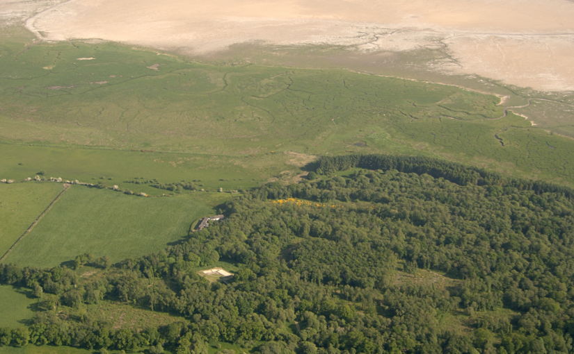
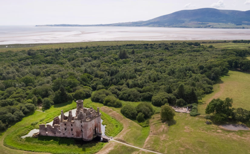
Thanks to funding from the Castle Studies Trust, Historic Environment Scotland are working with researchers Dr Richard Tipping and Dr Eileen Tisdall to understand the chronology and geography of extreme weather events in the high medieval period, and the effects they wrought on archaeological features that led to the abandonment of the old castle built in c.1229 in favour of the new built 200m away in c.1277.Here Richard Tipping gives an update on the fieldwork which too place last Saturday (2 October).
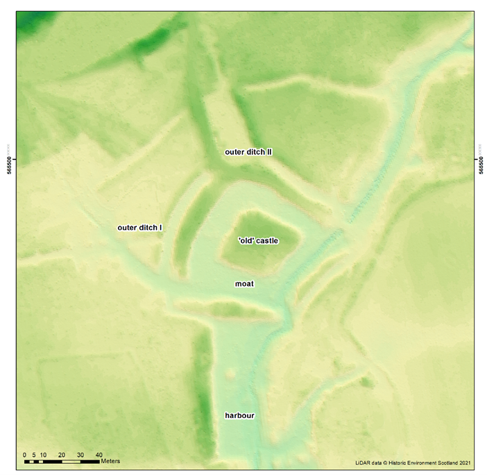
One of the great puzzles of old Caerlaverock is the so-called harbour (Image 1). It is south of the old castle, two metres lower, and just north of where we think the early medieval coastline was, so it’s difficult to think what else it could have been. But it’s never been independently dated, there are rumours that it was Roman, and there are knotty interpretative problems. One is that the floor of the harbour is at an altitude that would make it tricky to get more than rowing boats in and out in the Middle Ages; this is also a problem if the harbour was older. A second is that there is a fourth side at the southern end, which greatly restricts access. As Richard Tipping explains below:
The harbour has three metres of sand above bedrock. We don’t know how old the sand is. One idea is that it’s all very old – 8000-6000 years old. This would mean that the harbour was never deeper than it is now. Another idea is that the sand is of two periods, with an older bed covered by medieval sand: the same stuff that filled the moat of the Old Castle. And a third is that all three metres of sand are medieval in age. This would imply that the builders created a five metre deep harbour, which was then filled with sand as storm surges drove sediment onshore.
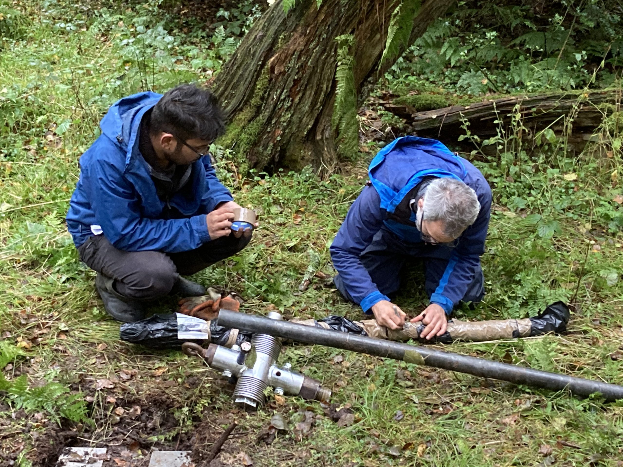
Dating of the sand is the answer. To this end, a team of eight (Richard Tipping and Eileen Tisdall from Stirling; Tim Kinnaird, Aayush Srivastava, Richard Bates and Laura Bates from St Andrews, and Morvern French and Steve Farrar from Historic Environment Scotland) assembled under gloomy skies and a more intimidating forecast to sample the sediment.
Here Richard Bates explains what they are going to do:
Richard Bates had a vibro-corer, a machine that went through three metres of sand as if it was butter: astonishingly impressive:
The three cores came out and were immediately wrapped in black plastic bags because sunlight, even that under grey clouds, cannot be allowed to shine on the samples. The reason for this bizarre behaviour is in how the sediment will be dated
Wrapping the sample
Tim and Aayush are specialists in optically stimulated luminescence (OSL) and infra-red stimulated luminescence (IRSL) dating. This is a kind-of accumulation clock. Over time, quartz and feldspar sand grains buried by sediment accumulate energy released from surrounding sediments at a constant rate. This energy is released if sunlight hits the sand, or under controlled laboratory conditions, when light at optical or infra-red wavelengths hits the sand. If the energy released can be measured, which is Tim’s and Aayush’s job, we can establish the age of the sand as Tim explains here:
The Castle Studies Trust grant will fund three OSL dates from the base of the sand, the middle, and towards the top. As soon as we learn the results, you will.
As Drs Richard Tipping and Eileen Tisdall along with Dr Tim Kinnaird of St Andrews return to Caerlaverock to carry out their final piece of field work this Saturday (2 October), Richard Tipping discusses what has happened so far.
Background
Earlier blogs have described the fieldwork, over the summer, at the Old Castle at Caerlaverock in south west Scotland. We have been testing the idea that several very large storm surges impacted the castle, persuading the occupants to re-build, higher up and further inland. That fieldwork involved recording sediments in the moat (Figure 1) and surrounding ditches, confirming that these sediment traps are full of silt derived, we think, from storm surges pushing sediment from the coast, through the harbour and into the moat. We’re checking the origin of the silt from diatom analyses, which can define water salinity. But we hadn’t found evidence that these storm surges were destructive, impacting archaeological features. Now we think we have.
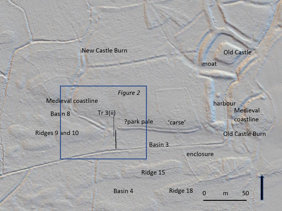
The ‘park pale’ is the name given to a ditched-&-banked enclosure that extends west from the harbour at the old castle for several hundred metres (Figure 1). It was constructed along a small cliff that marked the medieval coastline, separating mid-Holocene estuarine sediment, called ‘carse’ to its north and a series of very broad, parallel east-west trending ridges and basins constructed by medieval storm surges to its south (Tipping and Adams 2007).
Figure 1. Natural and archaeological features near the ‘park pale’ at Caerlaverock.
In Figure 1, a LiDAR image, Ridges 9 and 10, and Ridges 15 and 18 are seen. Between them, lagoon basins were trapped: Basins 8, 3 and 4 here. Some basins will be radiocarbon dated because peat formed when they were isolated from wave action.
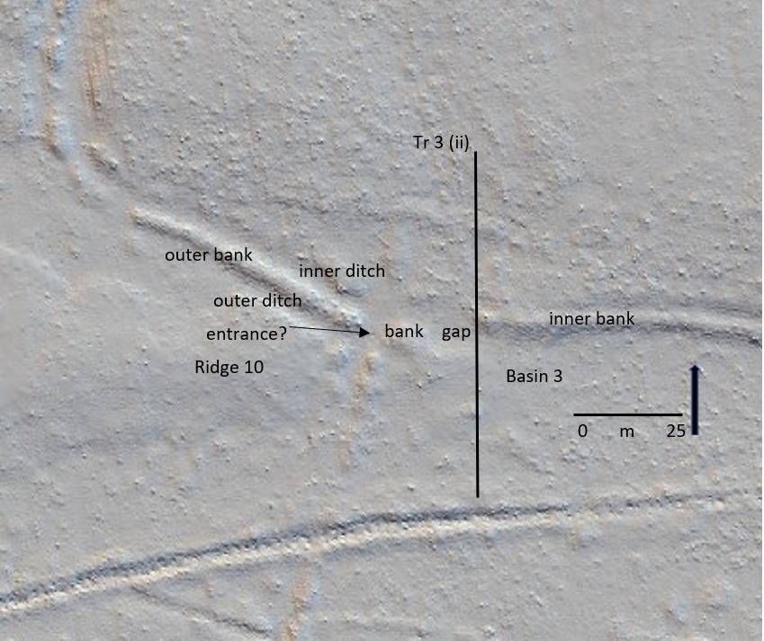
In detail (Figure 2) the ‘park pale’ is complicated. There is an inner bank to the east, with a crest around a metre higher than the ground to its south. This is lost at a 25m wide gap and cannot be traced further west. Instead, a second, lower outer bank continues north west to the New Castle Burn (Figure 1). The outer bank has, in places, an outer and inner ditch. Another, 4m wide gap may be what Brann (2004) thought was an entrance.
Tr 3 (ii) is the line of a 50m long sediment-stratigraphic transect of 24 hand-sunk boreholes from the ‘carse’ in the north, which the inner bank rests on, south across Basin 3 to the canalised Old Castle Burn. The transect was designed to test the idea that the 25m gap in the ‘pale’ is an erosional feature from storm surge impacts.
Figure 2. Features around the distinctive 25m wide gap in the ‘pale’
Stratigraphy
What Tr (ii) shows is that the low ground of Basin 3 is floored by bedrock less than a metre down. This is covered by well-sorted sand and then by poorly sorted coarse to very coarse sand and grit with common pebbles.This fills Basin 3, thickening shoreward. This is interpreted as a storm surge deposit, deposited in a high-energy marine environment. Boreholes on the inner bank, a metre higher than Basin 3, and 25m inland, also recorded thick gravelly sand, impenetrable at 90cm depth on the inner bank. This thins north but is still found 20m inland from the medieval coastline.
Narrative
There were at least two storm surge ridges formed before the events recorded in Basin 3. Basin 8 (Figure 1) was formed by the second storm surge, as yet undated. This created Ridges 9 and 10. These broad gravel ridges in turn protected the western ‘park pale’ from subsequent marine erosion (Figure 2). What is now the outer bank, with its associated ditches, probably represents the original boundary of the ‘pale’. The ‘pale’ pre-dates the storm surge event described here. It is shown by the sediment stratigraphy to be, broadly, medieval in age and, broadly, contemporary with the old castle.
Eastward, Ridges 9 and 10 merge with the ‘carse’ of the medieval coastline, leaving this part of the coast vulnerable to later storm surges. At this point, the outer bank of the ‘pale’ is lost. In its place are storm surge sediments. The ‘pale’ was eroded by the storm surge. This storm surge pushed at least 90cm of gravelly sand north onto the surface of the ‘carse’. The cliff may have been formed after this storm surge, by later erosional wave action. Gravelly sand was pushed or thrown 20m beyond the cliff. Waves also scoured the easily eroded ‘carse’, lowering the surface by around 0.5m, up to 100m inland.
Tipping, R. and Adams, J. 2007. Structure, composition and significance of medieval storm beach ridges at Caerlaverock, Dumfries & Galloway. Scottish Journal of Geology 43, 115-123.
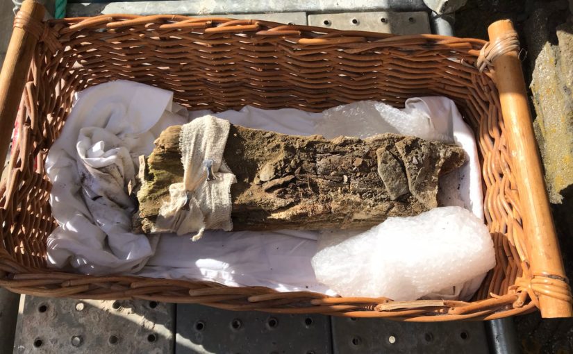
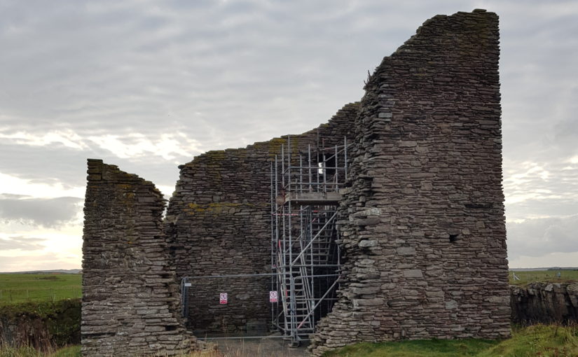
On Wednesday and Thursday 22nd and 23rd of September, a team lead by Rachel Pickering of Historic Environment Scotland and Coralie Mills undertook to remove the remains of wooden joist from the keep at Old Wick Castle. The joist hole was 8 metres above ground level. If successfully removed the joist was then to be taken away for testing and hopefully provide a date for it and the castle. In a slightly different blog than usual here are three short videos looking at how the removal process went.
As the Old Wick project gets underway, the project lead Rachel Pickering of Historic Environment Scotland explains what they are trying to find out and how.
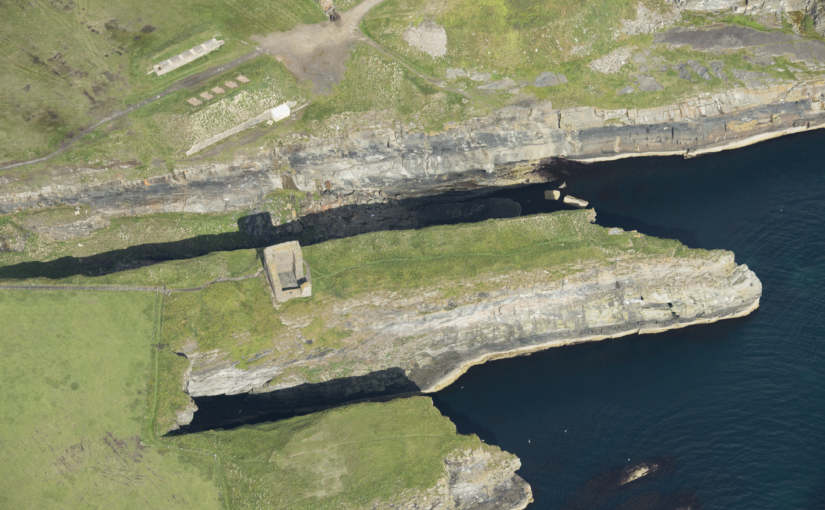
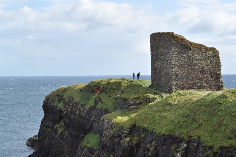
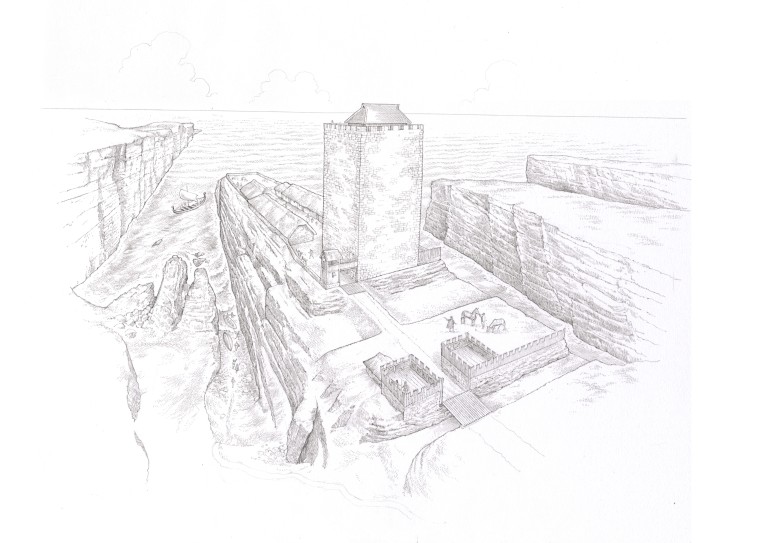
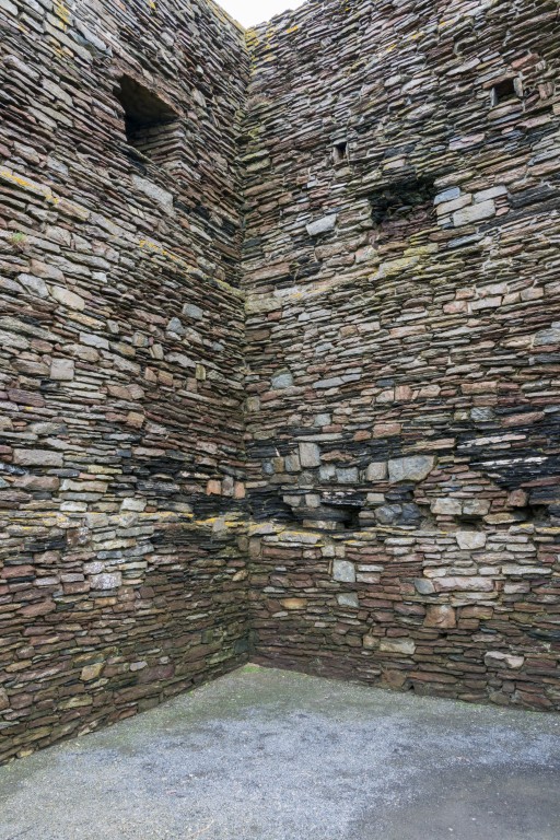
In the far northeast of mainland Scotland, on a narrow promontory, surrounded by cliffs on three sides, stand the ruins of Castle of Old Wick. The castle is one of Caithness’ most striking medieval sites due to its rugged location. But time has not been kind to the castle, and all that survives above ground is the stark stone skeleton of a once grand tower, within low-lying earthworks on the promontory behind. There are many unanswered questions about this castle, not least ‘when was it built?’.
Very little is known about the castle’s origin and development – there is limited documentary evidence relating to its earlier history and no diagnostic architectural features survive, making it very difficult to date. It was once thought to have been one of the earliest stone castles in Scotland, associated with Norse earls of Orkney and Caithness. However, more recently, scholars have questioned this, suggesting a 14th century date is much more likely for its construction.
One tantalising clue survives that may shed light on its construction history – a single fragment of timber within a joist socket of an upper floor. The image below shows these joist sockets which indicate the tower had timber floors throughout. The sole surviving timber is increasingly at risk of decay as it is exposed to the elements. Our aim is to remove the timber and assess it for dendrochronological analysis – or tree-ring dating, before conserving the remains. From this we may be able to get a scientific date to indicate when the castle was built. At the very least, such a date may provide an age and provenance for the timber joist which provides an insight into phases of the castle’s development.
Thanks to generous grant funding from the Castle Studies Trust, HES and specialist contractor Dr Coralie Mills of Dendrochronicle will be carrying out new research this autumn, with the hope of recovering dating evidence.
The timber is believed to be oak, making it suitable for dendrochronological analysis, though it is in a very fragile state. It will be accessed using a scaffold and very carefully removed and wrapped before being transported to the laboratory in Edinburgh for detailed examination. Its condition and suitability for dendrochronological analysis will then be assessed. If it is not possible to analyse the rings of the timber due to its condition, then an alternative method will be undertaken using radiocarbon ‘wiggle matching’. This would involve taking several samples for high precision radiocarbon dating, allowing for a more accurately calibrated radiocarbon date for the timber.
We hope this research will shed light on the construction and development of Castle of Old Wick, by providing valuable scientific dating evidence. The project will also potentially support the on-going development of dendrochronological analysis within Scotland, as every new analysis can help to add to and refine existing tree-ring chronologies, which in turn supports future research.