The Castle Studies Trust is delighted to announce the award of eight grants, totalling a record £44,500, to a wide range of projects involving a wide variety of research methods. This total means that, since our foundation, we will have given nearly £350,000 to castle research projects – a landmark to celebrate.
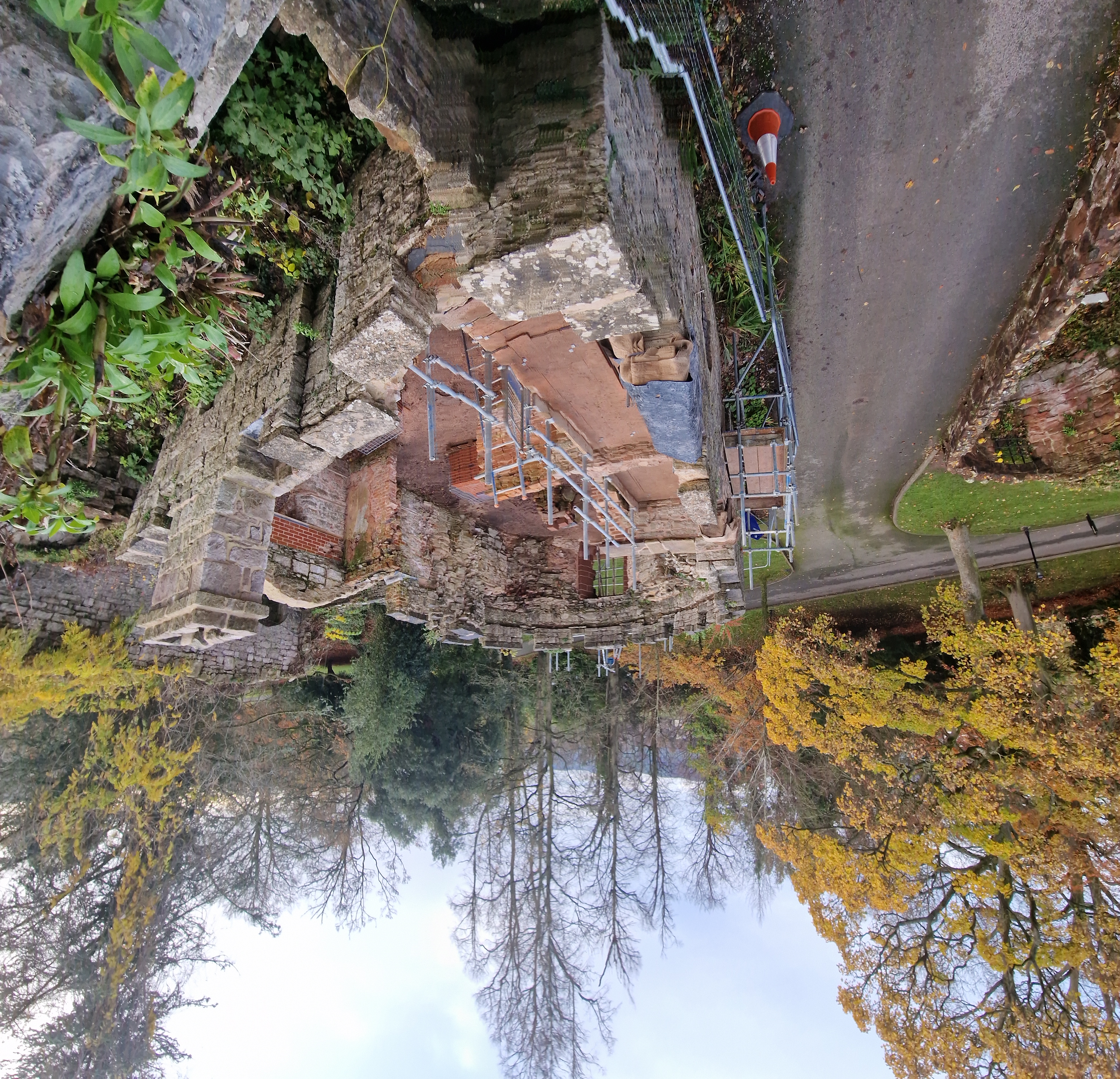
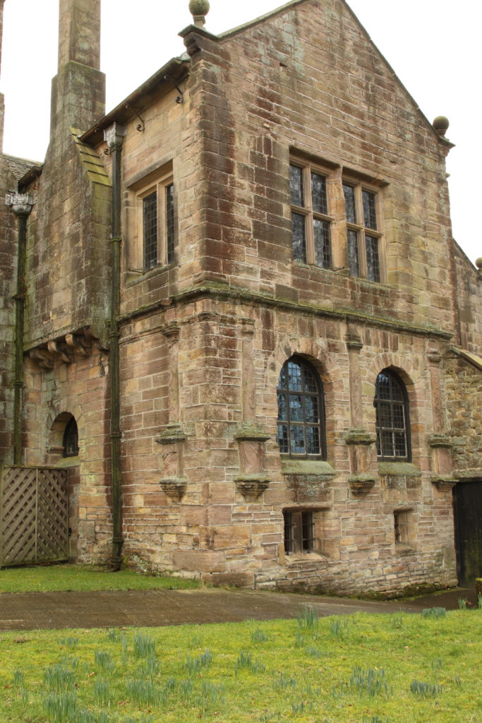
Cockermouth Kitchen Tower and Great Hall Range from river, copyright Richard Oram
Cockermouth, Cumbria: Cockermouth Castle is an extensively surviving major multi-phase northern fortress whose evolutionary history has never been subject to systematic or formal assessment. The building survey will focus upon developing a detailed understanding of the physical fabric of the castle’s inner ward structures with a view to mapping their evolution, and to provide contextualization by relating the major building periods to the site’s known history and occupancy, and in terms of the broader evolution of castle architecture. The survey will be carried out by Tom Addyman with the support of Edward Impey and Richard Oram.
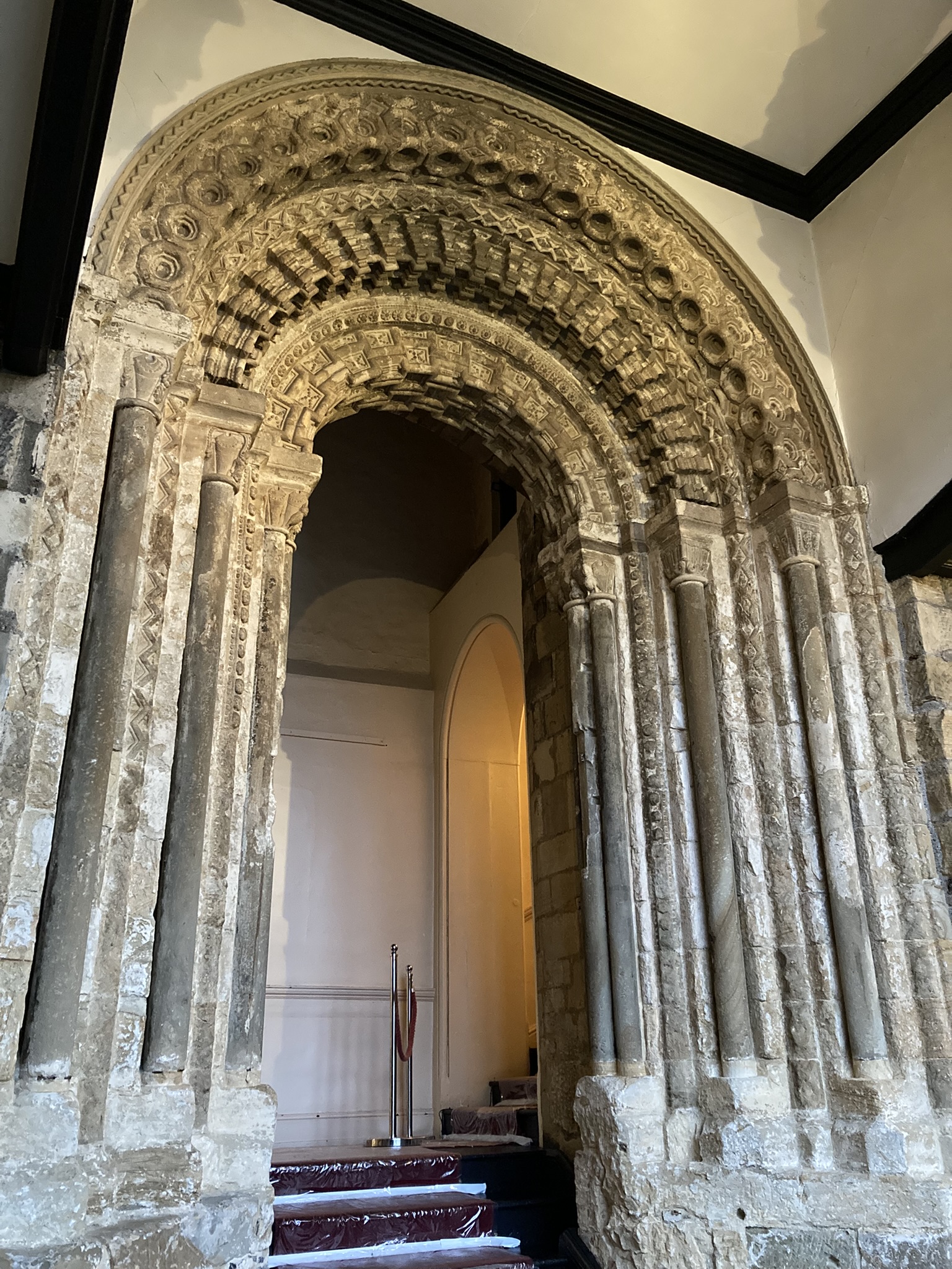
Durham Castle’s twelfth century entrance way, copyright Dr Andrew Ferrara
Durham Castle, County Durham: Investigating the Twelfth-Century Entranceway of Durham Castle. The aim of the project is to utilise digital archaeological techniques to create high-resolution images and models of the twelfth-century archway into Durham Castle’s North Range, enabling detailed investigation of the architectural features. The Durham University team carrying out the work will be led by Andrew Ferrara and Giles Gasper.
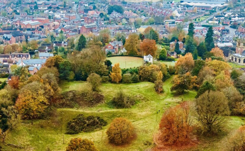
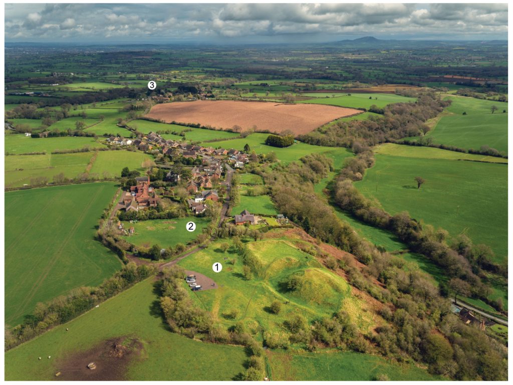
Ellesmere Castle from the air, copyright Joe Bickerton
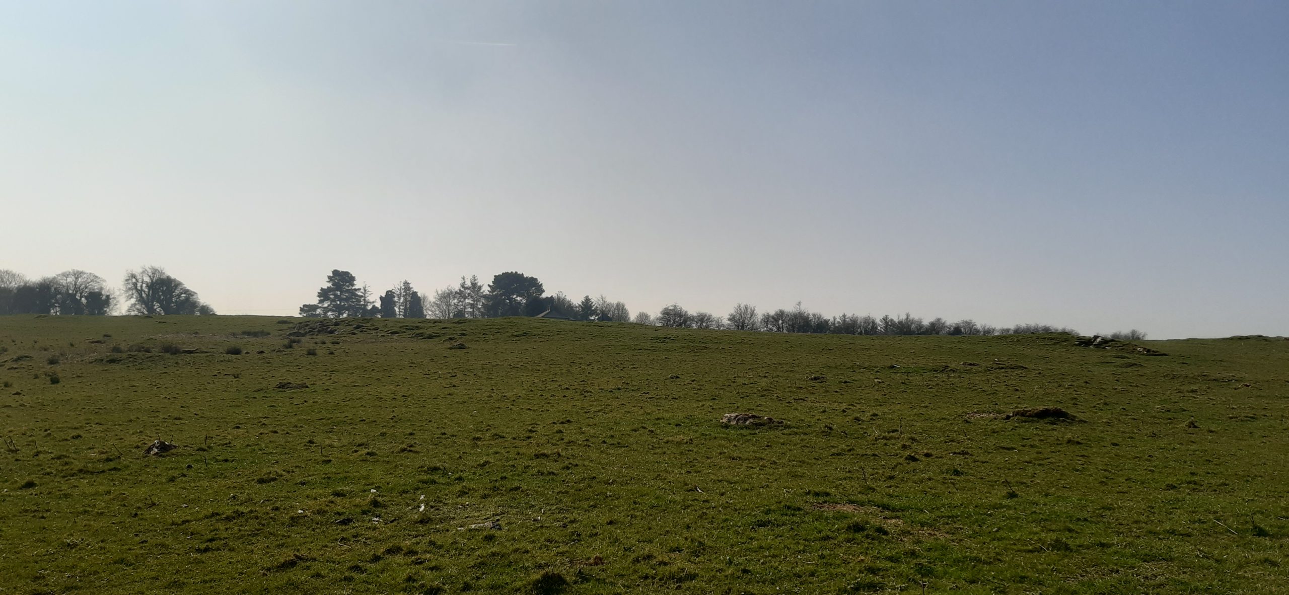
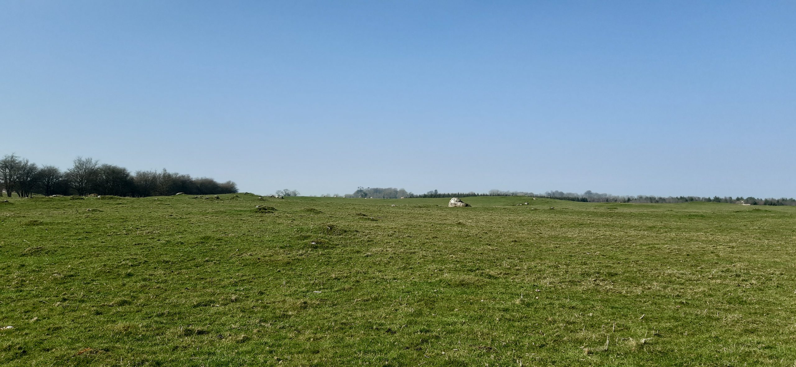
Ellesmere, Shropshire: Geophysical survey of the large motte and bailey castle in Shropshire which, prior to June 2024, had never been surveyed before when the large motte was surveyed by GPR which revealed possible buildings. The resistivity and magnetometry surveys would confirm that, as well as extend the survey to the rest of the site which played an active part in the Marcher disputes in the reign of Henry III. The survey, carried out by Heneb, will take place in the week starting 9 March, with the results ready in the early summer.
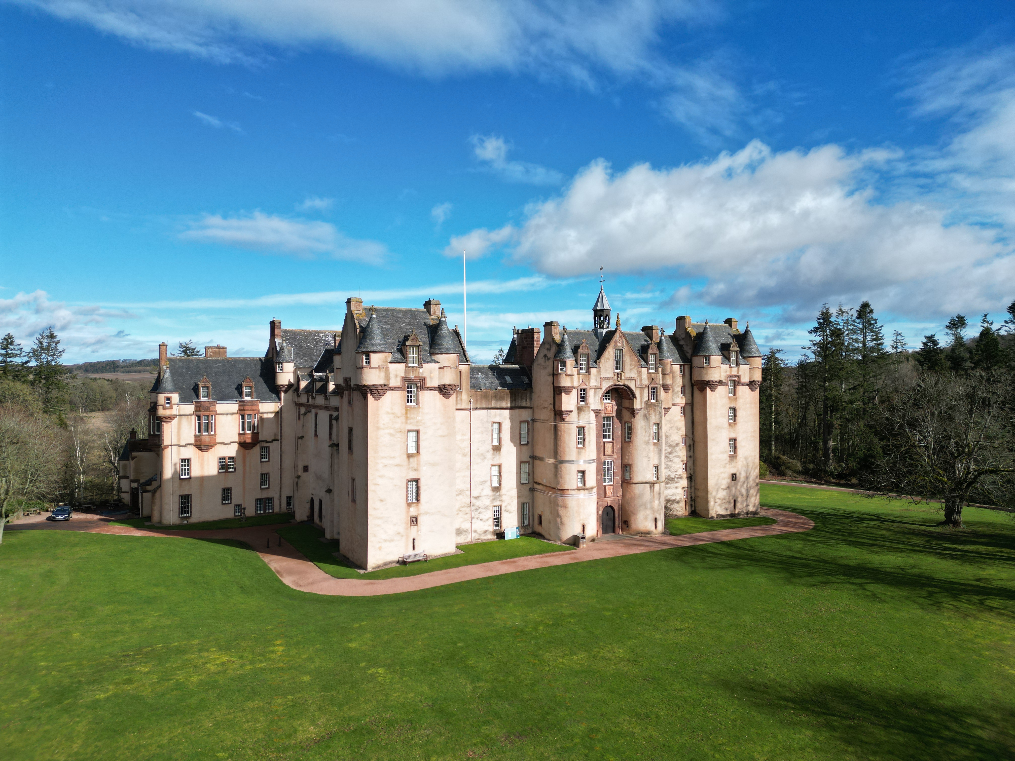
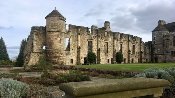
Fyvie Castle, copyright National Trust of Scotland
Fyvie, Aberdeenshire: The project aims to create new interpretation drawings to showcase key stages in the architectural development of the castle, which dates to the thirteenth century, and share these as part of outreach and engagement. The drawings by Jan Dunbar will be commissioned by Annie Robertson of the National Trust and are expected to start in April.
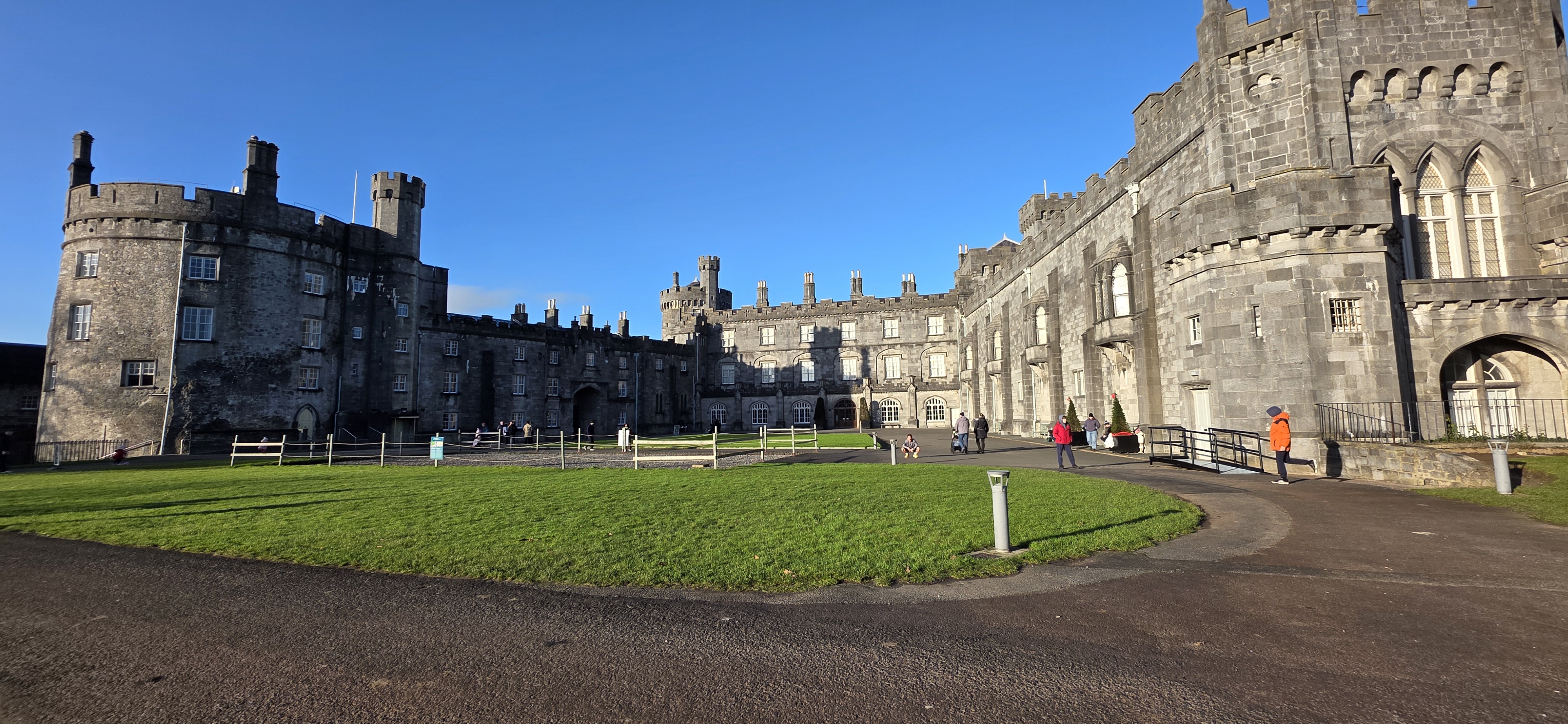
Kilkenny Castle, copyright of the Discovery Programme
Kilkenny, Leinster, Republic of Ireland: This project proposes the use of geophysical survey to locate and map the lost Flemingstown of Kilkenny Castle – a unique example of a purpose-built Flemish colonial suburb. While some of the outer ward has already been investigated, the one area missing has been around the site of the township’s tower. The geophysical survey will be carried out by The Discovery Programme and will take place in early to mid March, led by David Stone with the support of Susan Currant and Coilin O Drisceoil.
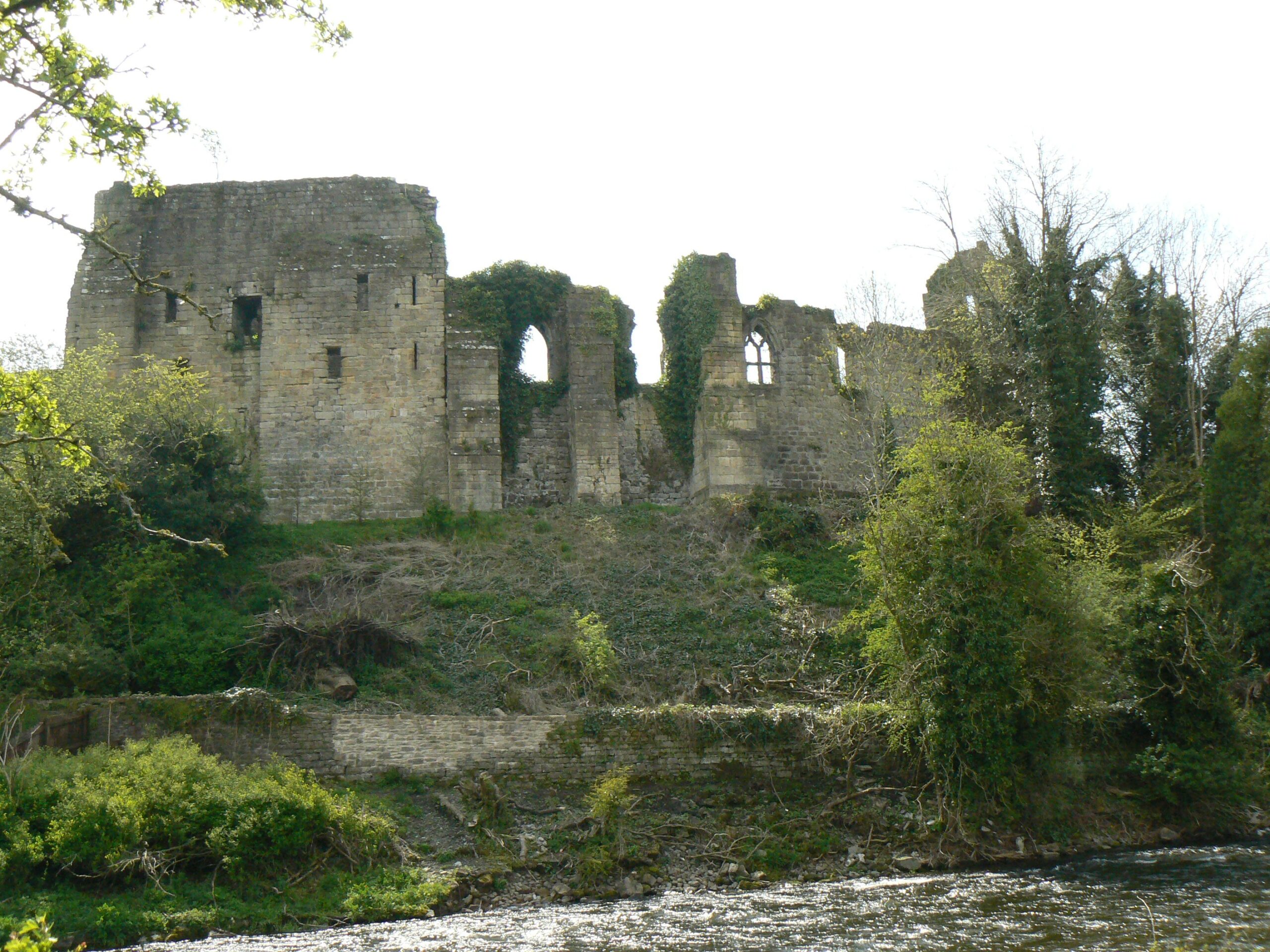
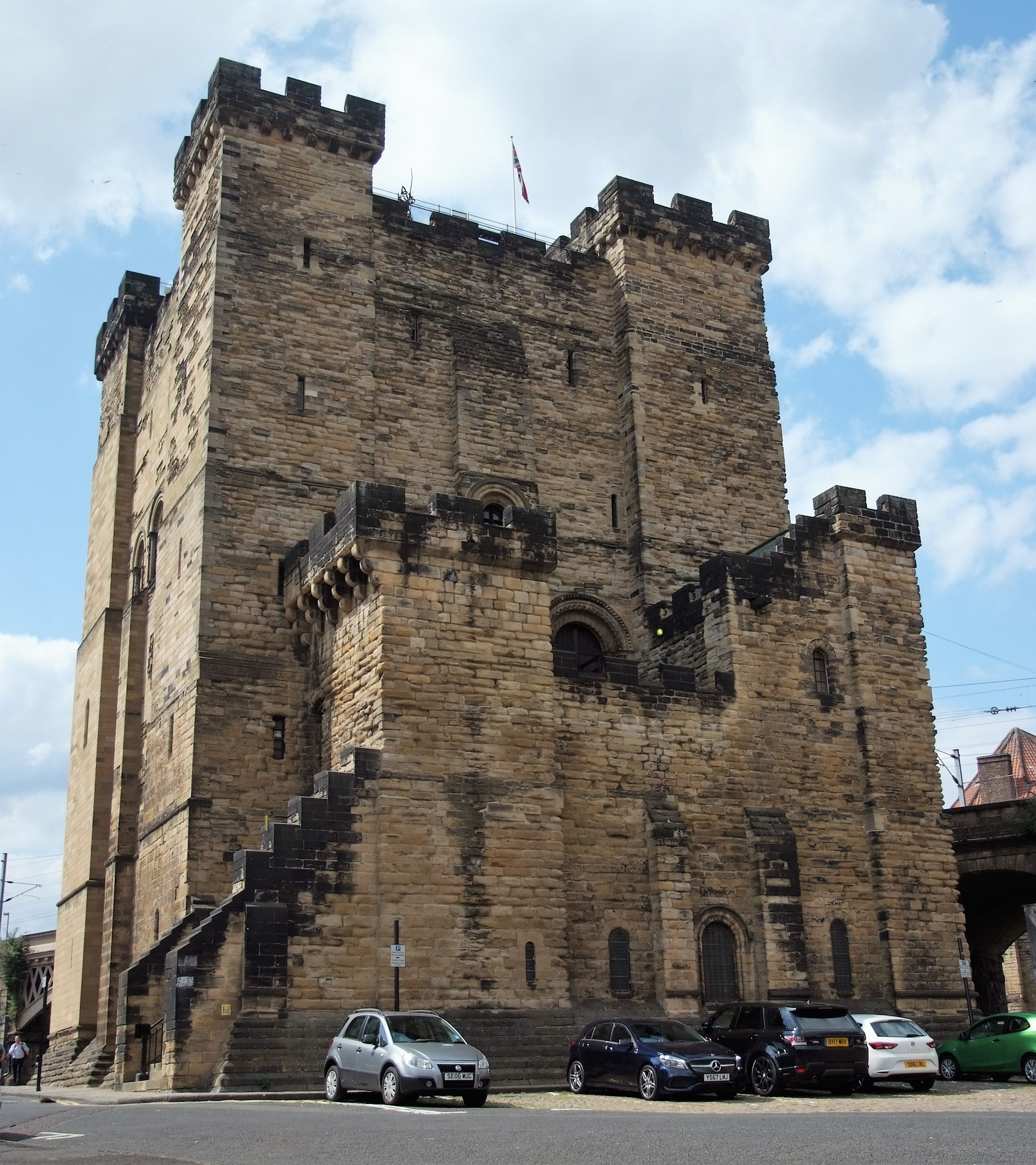
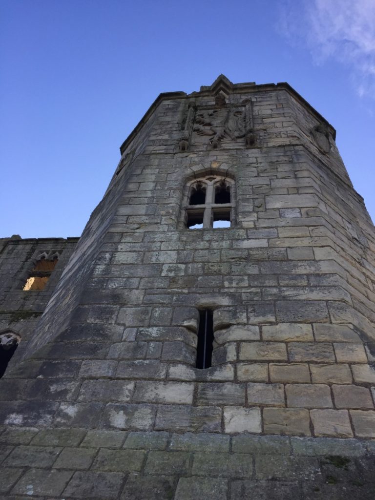
Newcastle Keep, copyright Peter Purton
Newcastle, Northumberland: To co-fund the publication of the report of the excavations of Newcastle Castle, one of the major royal castles in the North East of England, which took place over 20 years between 1974-95. The funds will be for synthesising all the different excavations, updating specialist reports and preparing relevant reports. We are only part funding £2,000 of the £8,000 asked for, as we lacked the means to fund any more. . The grant from the CST will allow him to commission the illustration work for the building interpretation and the excavation illustrations. The part funding has also spurred on other funders to cover the remaining part of the grant. The project will be led by Don O’Meara of the Society of Antiquaries of Newcastle with the support of John Nolan and Richard Pears.
Ruthin Castle great gatehouse, copyright Ruthin Castle Preservation Trust
Ruthin, Denbighshire: Co-funding a structural survey and analysis of the great gatehouse of this formidable thirteenth century baronial castle that was a key part of Edward I’s strategy to secure the conquest of Wales. The project is led by Fiona Gale, chair of the Ruthin Castle Preservation Trust who will commission Mann Williams to do the survey with add context provided by Will Davies from Cadw.
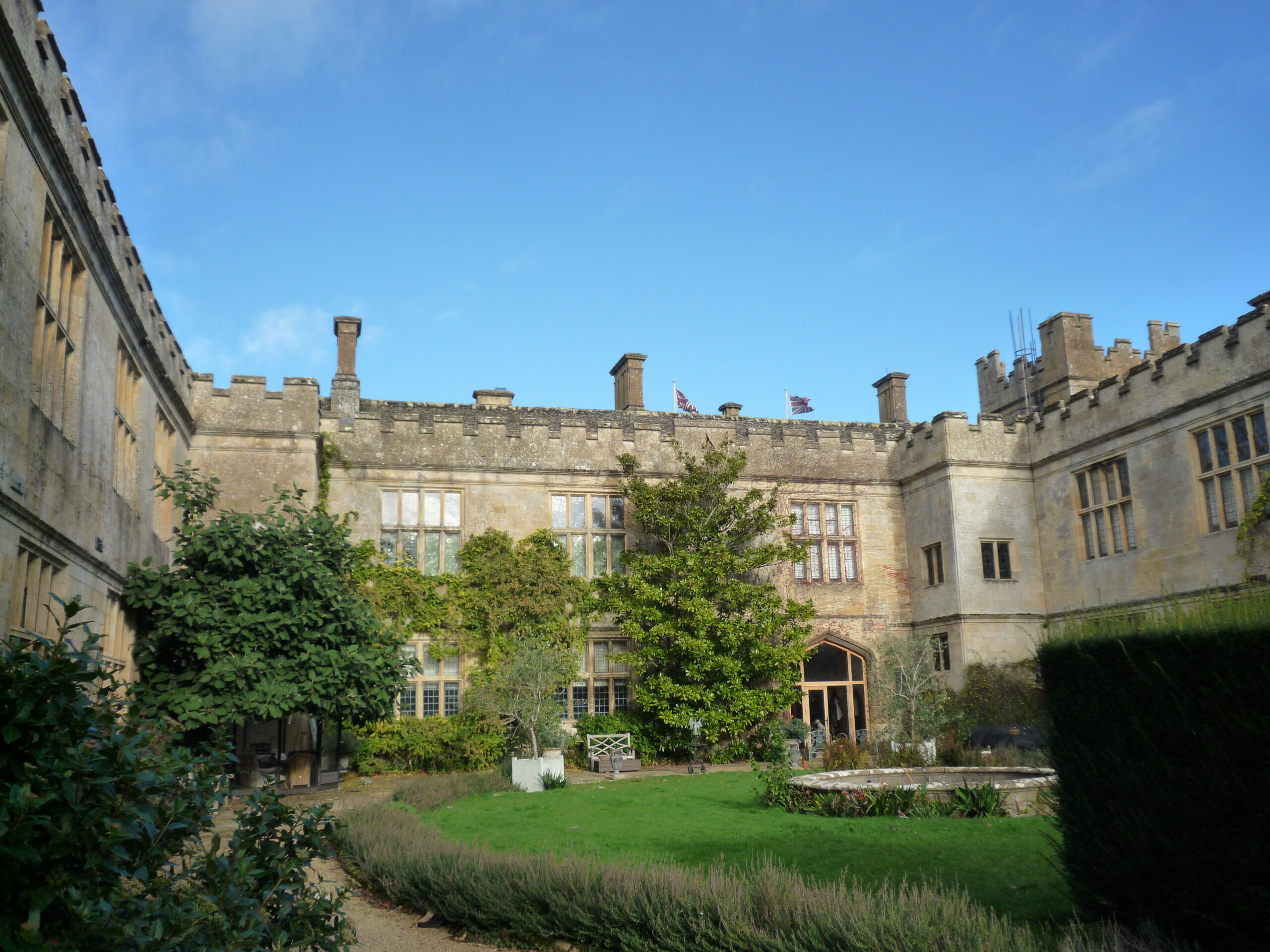
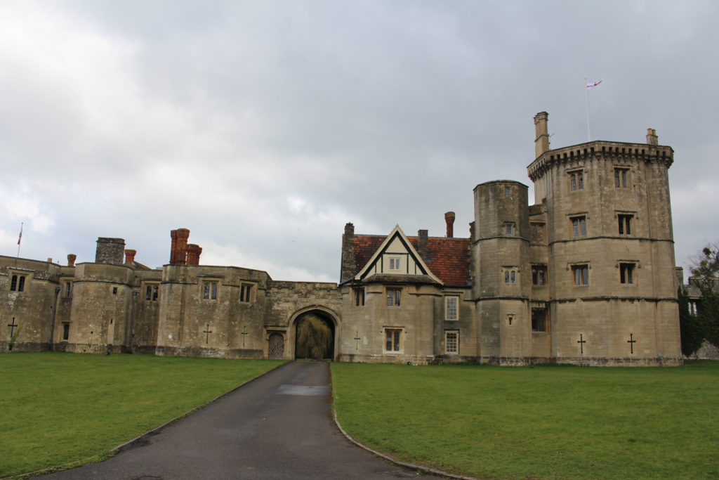
Sudeley Castle outer courtyard, copyright Andy Moir
Sudeley Castle, Gloucestershire: Tree-ring dating and recording with 3D imaging the original roofs of Sudeley Castles Outer Courtyard Ranges. The castle site dates to the anarchy but the castle was rebuilt in the fifteenth century by Lord Sudeley. The sampling and photography will take place on 25 and 26 February. The project will be led by Andy Moir of the Gloucestershire Building Recording Group.
The deadline for grant applications passed on 1 December. We’re going through the various projects now. Altogether the 15 projects, coming from all the home nations and one from Ireland, are asking for over £110,000. They cover not only a wide period of history but also a broad range of topics.
We will not be able to fund as many of these projects as we would like. To help us fund as many of these projects as possible please donate here:
In a little more detail here are the applications we’ve received:
Bamburgh, Northumberland: The aim of the project is to better understand the outworks to the north of the castle, by using various geophysical survey techniques and a preliminary survey of the masonry remains, it will include a 3D model of the recently excavated Elmund Tower and provide materials for interactive displays.
Barnard Castle, Co Durham: The aim of the project is to try and understand a lot more about the outer ward of the castle, using a variety of methods including geophysical survey, aerial survey and test excavation
Cavers Castle, Roxburghshire: Through a combination of building survey and excavation to try to understand the early form of this important baronial castle.
Dunoon, Argyll: A community-led geophysical survey project to understand better the form and scale of this important castle that was the seat of the Lord High Stewards of Scotland. The original castle dates back to the 1200s and the remains above currently ground date from the fourteenth century.
Fun Kids, Castle Podcasts for 7-13 Year Olds: To produce a series of 8 podcasts for children aged 7-13 to engage children to explore a what, how and why of 8 castles. The series will focus on a variety of castles and build awareness of less common castles that families can explore.
Galey, Co. Roscommon: Geophysical and topographical surveys to explore the possible motives behind the placement of, as well as immediate landscape context, morphology and any attached settlement and industrial activity, that occurred at a lakeshore-sited late medieval Gaelic-constructed tower house castle.
Hartlebury, Worcestershire: The seeks to explore what looks like a possible civil war bastion ditch, which seems to have been partially revealed in a 2022 drone survey of this former bishop’s palace with remains dating from the fifteenth century. This will be done through geophysical survey and excavation.
Lowther Castle, Cumbria: Through a combination of geophysical survey and excavation to try to learn more about this ringwork castle and settlement, thought to date from the late eleventh century. the aim is to try to discover if it dates from this period and was therefore a Norman plantation; and also its history after its foundation.
Millom, Cumbria: The project will involve a drone survey to assess the condition of the 14th century fortified manor combined with a geophyisical survey to understand if there is any link between it and the nearby church and monastery.
Muncaster, Cumbria finds assessment: To make a complete assessment of the finds from the 2021 excavations which took place near the 14th century tower along with two nearby kiln sites.
Muncaster, Cumbria geophys and archaeology survey: To carry out a geophysical survey of the area surrounding the castle and to investigate a large stone feature in the cellar of the castle to understand its purpose and possible date
Northern Frontier, Beacon Hill Yorkshire: A geophysical survey of Pickering Beacon Hill, a siege castle used for the siege of Pickering in the lead up to the Battle of the Standard (1138) to better understand the landscape at the time and see how much life was disrupted during the period known as the Anarchy.
Picton, Pembrokshire: The aim of the project is to achieve a full understanding of the form, functions and affinities of the medieval part of Picton Castle through a building survey. It has an unusual plan with no close parallels within Great Britain, but shows some affinities with castles further afield including, possibly, Gascony in France
Snodhill, Herefordshire: Excavation to explore the early masonry defences and attempt to resolve the entrance arrangements and to do a geophysical survey of the Eastern Bailey
Wigmore, Herefordshire: To provide a digital reconstruction drawing of Wigmore Castle using a mixture of archaeological and archival evidence
We will not be able to fund as many of these projects as we would like. To help us fund as many of these projects as possible please donate here: Kindlink Donation Form App
Vicky McAlister, project lead of the Geophysical Survey of Kilmachill explains the reasons behind the survey.
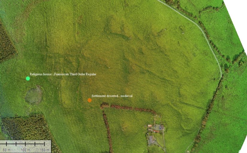
“Can we use drone (UAV) gathered imagery to see how spaces around castles were being used?” This was the question that spurred the addition of geophysical survey to a wider study of the landscape surrounding the deserted medieval settlement complex at Kilmacahill, County Westmeath. The data will then be delivered to the Human-Environmental Exchanges in the Landscape (HELM) project team for analysis to detect possible subsurface archaeological remains. HELM is led by project co-Principal Investigators Dr. Vicky McAlister and Dr. Jenny Immich, with Target Archaeological Geophysical GVC commissioned to undertake the survey.
Kilmacahill was selected for this interrogation because of its layered landscape history and good above surface archaeological remains. The vernacular settlement site of Kilmacahill is adjacent to a Franciscan Third Order Regular monastery and within visual range (c. 1km) of Joanstown motte and bailey, located to the west of the site. The work at Kilmacahill already undertaken includes UAV collected aerial photographs and topographic data over the deserted settlement complex for analysis in geographic information systems (GIS) software.
Geophysical Area 1
In its first project phase (2019-2021) HELM addressed the theory that Anglo-Norman medieval vernacular settlements could be found in close physical proximity to elite secular and religious sites. More specifically, we hypothesised that peasant settlement could be found clustered around castle sites, parish churches, and monastic sites. To test this theory, HELM analysed UAV-gathered data for four castle sites in counties Limerick and Tipperary. At three of these four sites we found what we interpreted to be burgage plots clustered in the area between the castle and parish church. One of them, Glenogra in County Limerick, looked to have a deserted medieval village showing different areas and types of house plot compared to the very planned and regular appearance of such plots at the other sites. We wondered if this indicated that both Anglo-Norman settlers and Gaelic Irish tenants were living in this settlement.
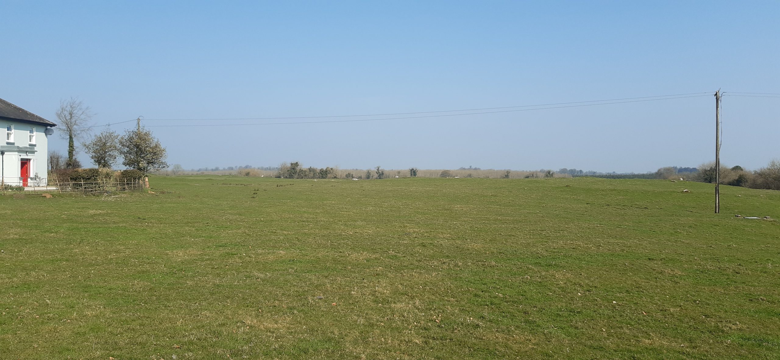
Geophysical Area 2
This led the HELM team to begin phase two of the study, which is looking at three potential deserted medieval settlement sites in County Westmeath: Fore, Kilbixy, and Kilmacahill. Westmeath was the contact zone or frontier between the Anglo-Normans and Gaelic Irish for an extended period of time. This duration made us interested in what the medieval settlements associated with castles there looked like morphologically: more like Glenogra and haphazard, or something else entirely?
In late 2021, thanks to funding from the American Philosophical Society, Dr. Paul Naessens of Western Aerial Survey collected data from UAV flights at these three sites. At one of them – Kilmacahill – he also tested a new addition to the arsenal of digital archaeologists: UAV-mounted multispectral cameras. Multispectral data is traditionally used by scientists as an effective tool to examine soil productivity and plant health. In archaeological contexts, multispectral imagery can be analysed to reflect relative differences in vegetation health as a proxy to indicate near-surface or subsurface anthropogenic features – such as field boundaries made of stone, pits with charcoal in them, crushed gravel pathways, or other architectural features. The vegetation above these man-made features appears not as healthy as that above natural ground in the data analysis. The UAV-gathered photogrammetry data showed some interesting house plots, but also details of a complex circular enclosure not listed on the Sites and Monuments Record.
Geophysical Area 3
The HELM team agreed that concentrating our resources on one site would help to test our methodology and thus we applied to the Castle Studies Trust for funding for geophysical survey. We hope that the combination of three methods will tell us the most about vernacular settlement located between the Franciscan house at Kilmacahill and the motte castle at Joanstown. We will also be able to test the robustness of our UAV-based methodology against geophysics, which is much more expensive but is standard practice for identifying low-lying archaeological features. Geophysics currently costs up to ten times the amount of flying a site with a drone, so if we are successful in using UAV data to identify castle features, then this will be good news for everyone seeking to know what’s going on around their sites!
The data produced by the three collection methods (UAV photogrammetry, multispectral, geophysics) will be incorporated in GIS software to create a visual of the immediate subsurface archaeological remains of the DMV and will uncover finer features of the site as a whole. The HELM team should have the exciting results of the surveyed area by Autumn 2022.
In its latest round of grants the Castle Studies Trust has awarded £34,000 to five projects including two projects outside the UK. As well as covering a wide geographic area the projects will also undertake a broad range of technics to boost our understanding of castles.
Dating medieval towers in the hinterland of Medieval Chalkida, Greece:
Mytikas South Tower copyright Andrew Blacker
Stand-alone medieval towers, often part of castles or larger fortifications, are common in Central Greece. Often thought to have been built by the Frankish nobility during their period of dominance between 1204-1470, there is minimal evidence to back this up. By taking wood and mortar samples, the project aims to answer that question.
The present project forms part of the five-year survey ‘Beyond Chalkida: Landscape and Socio-Economic Transformations of its Hinterland from Byzantine to Ottoman times’ (authorised in July 2021 by the Greek State)
Samples will be taken from six towers of wood used laterally within tower walls to increase their structural strength, and mortar from within the core of the walls (both therefore probably
contemporaneous to the original period of construction). Specialists will use dendrochronological and
Carbon 14 methodology for the wood (8 samples), and optical microscopy, Scanning Electron Microscopy (SEM), and X-ray fluorescence (XRF) and diffraction (XRD) Spectroscopy (mortar – 21 samples).
Work will start at the earliest in late 2022 and may not actually take place until next year due to the time it is likely to take to get official permission from the government.
Kilmacahill, Co. Westmeath
Geophysical survey of deserted medieval settlement close to Jamestown motte & bailey castle. The aim is to understand the morphology of settlement and its relationship with the castle and medieval monastery.
This survey will contribute to a larger project: the Human-Environmental Exchanges in the Landscapes of Medieval Ireland Project (HELM Project) which aims to use a combination of multispectral imaging, UAV drone survey along with geophysical survey to gain a much better understanding of the form of the deserted medieval village through non-invasive methods.
At time of writing it was unclear when the survey will take place.
Pontefract, West Yorkshire
Pontefract Castle: Service area between the kitchen and royal appartments copyright Angela Routledge, Wakefield Council
The project funded will be a geophysical survey of two parts of the castle, which during its history was the main royal castle in Northern England, not previously investigated. The survey will be of two areas of the castle using Magnetometry, Resistivity and Ground Penetrating Radar (GPR)
The focus is on parts of the castle not previously explored by excavations in the 1980s, especially around the northern ramparts. This area stretches from the Swillington Tower towards the Kings Tower, and includes several earthwork features which remain unidentified, or unconfirmed. Geophysical investigation is likely to reveal several interesting features including the link wall between the curtain wall and the Swillington Tower, which is unique in that it was built outside the main castle defences.
A second area that we have very little information on is part of the castle known as the “service buildings”. This area has never been excavated and we have very little knowledge regarding the layout or function of this part of the castle.
As yet it is unclear when the survey will be undertaken.
Raby, Co Durham:
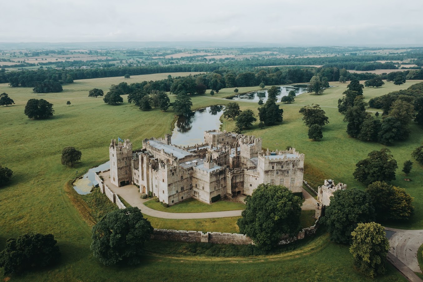
Aerial View of Raby Castle copyright Raby Castle
The Trust will be co-funding the project which aims to improve the understanding of the castle in the medieval period, especially around 1400 in the decades immediately after the licence to crenellate, with a buildings survey and development of a 3D model.
Once a stronghold of the Neville family, it moved into the ownership of the Vane family in 1626 and has been much altered and modernised, especially in the Victorian period, into a palatial family home. Large sections of the medieval castle survive intact, albeit intersected and extended with more recent architectural additions.
This project seeks to strip back the more recent layers, to make sense of the medieval castle. Our aim is to create a 3D visualisation of Raby Castle in around AD 1400, helping us to visualise and to understand (where possible) how it functioned before the later additions.
In addition to boosting our understanding of the castle, the plan is also to train up a team of volunteers in how to carry out a building survey.
The aim is to start the survey work in April.
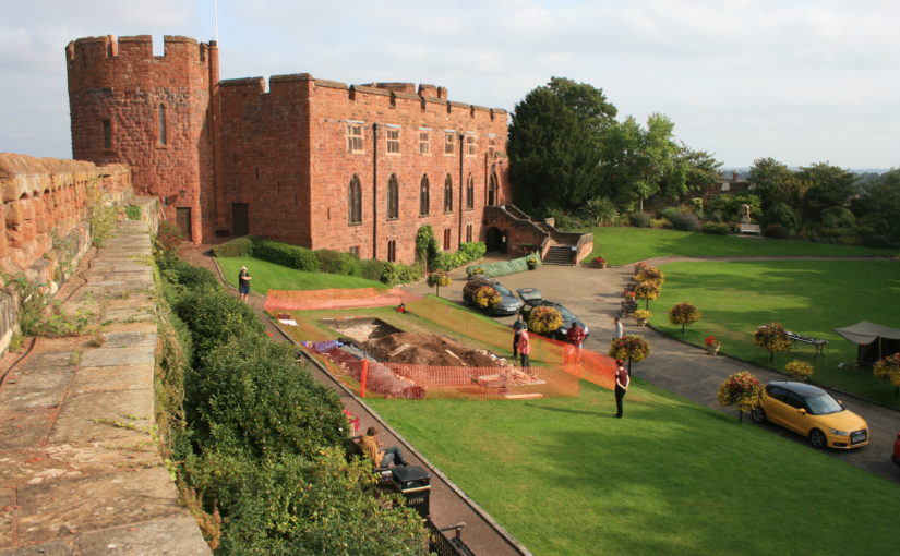
Shrewsbury, Shropshire:
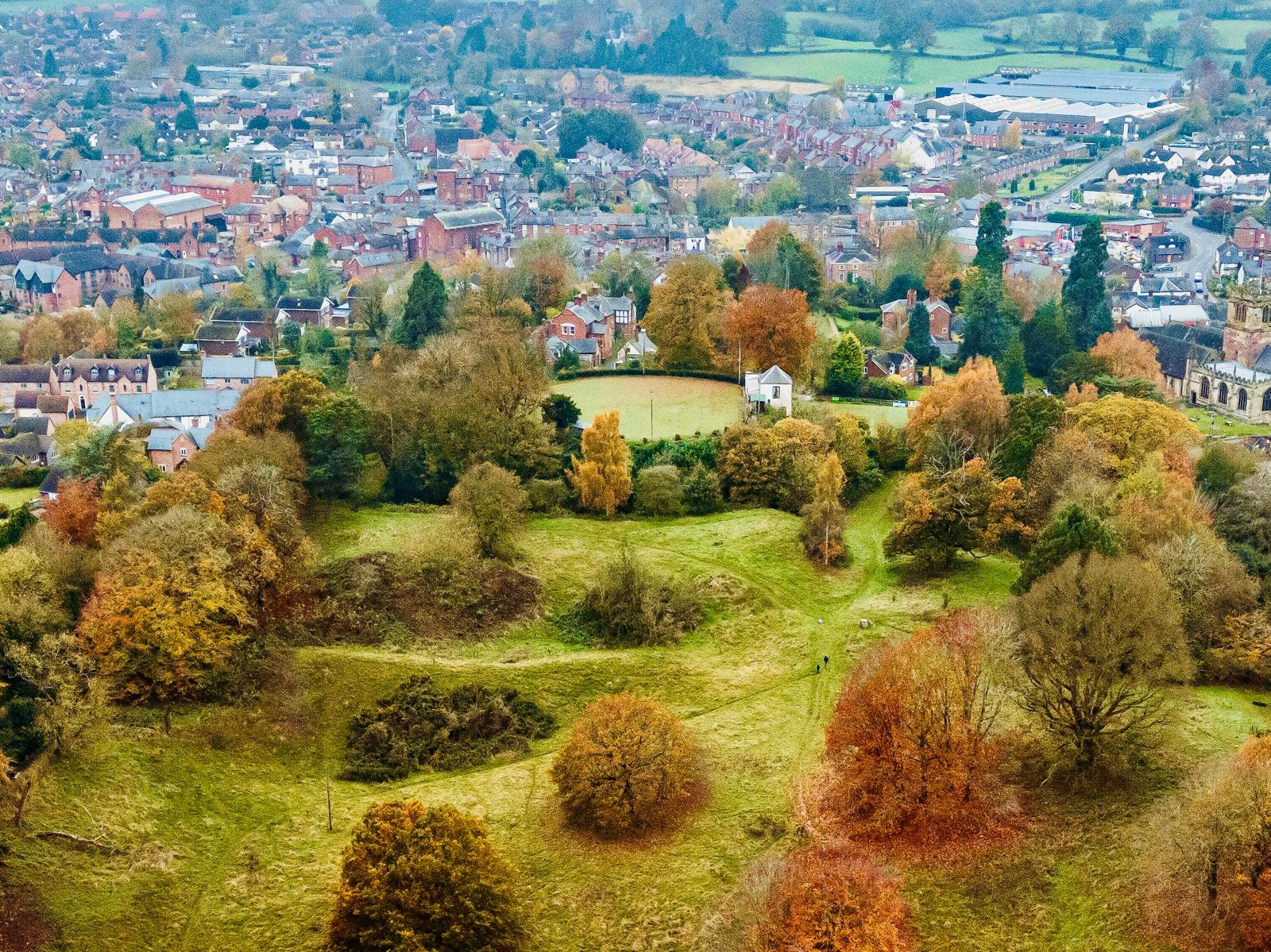
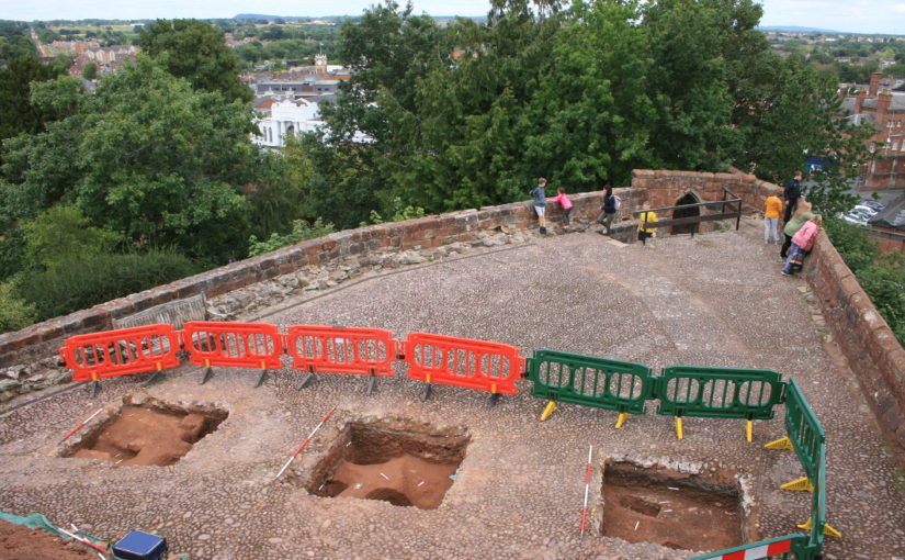
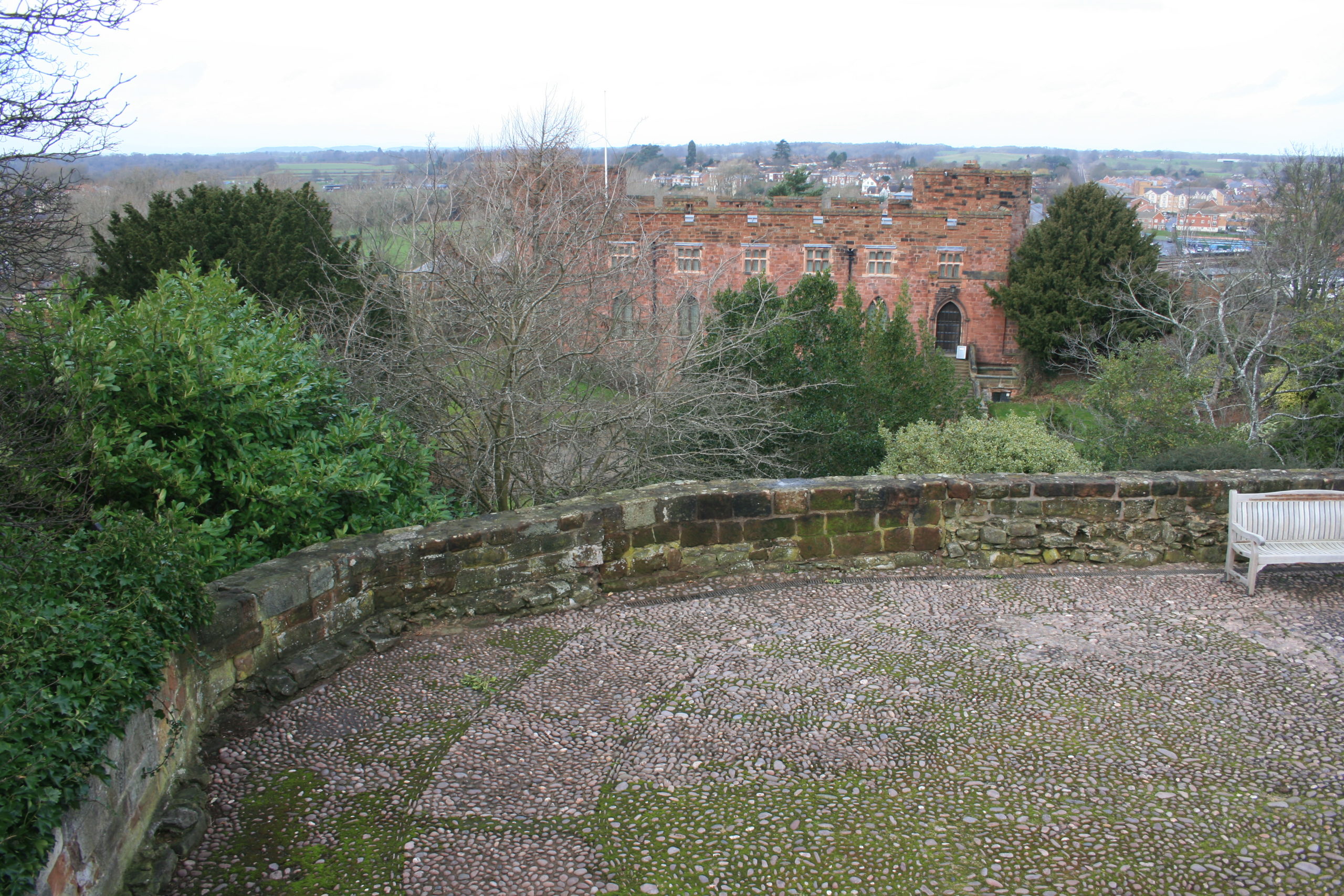
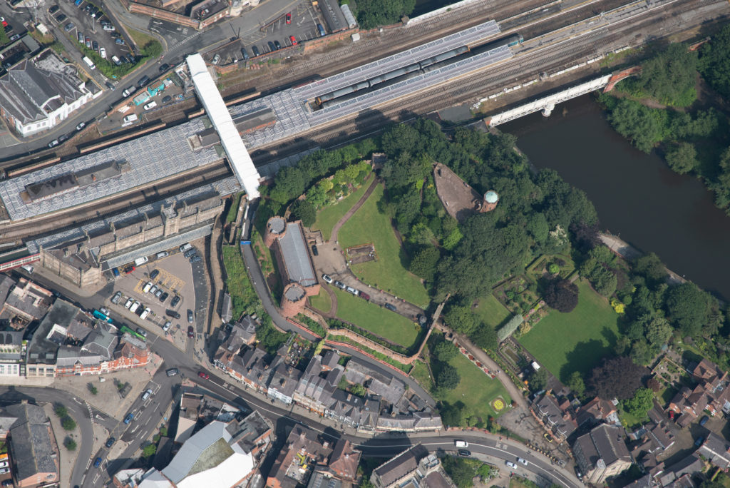
Shrewsbury Motte Top copyright Nigel Baker
This is the third project the Trust has funded on this important castle of the Welsh Marches and is an excavation of the motte top. The first two excavations in the inner bailey discovered that the original inner bailey was a lot smaller than it is today with little room for any substantial buildings, especially the royal hall.
This leaves only the motte and the aim is to understand the structural sequence and assess the character and the status of the buildings there: specifically to identify the royal hall known to be present during the Middle Ages.
The excavation is due to take place in the second half of July.
In 2020, the Castle Studies Trust funded Dr Karen Dempsey to undertake an innovative new line of research in castle studies, namely to explore the use of plants in castles in medieval Ireland. In this article, Karen explains what she and her colleague Dr Fiona MacGowan discovered.
Over the course of this Pandemic many people have a newfound or renewed appreciation for the green world that we live in. This might take material form by growing potted plants at home and if fortunate caring for a garden space of your own or somewhat less tangibly, the contemplation of changing seasons in your local park. The (anecdotal) health benefits we might feel from these activities are increasingly underscored by health professionals who assure us of the roles of green spaces in wellbeing. This connection is not a modern phenomenon – plants (and gardens) played a significant role in the diet, healthcare and spirituality of people living as part of castle households.
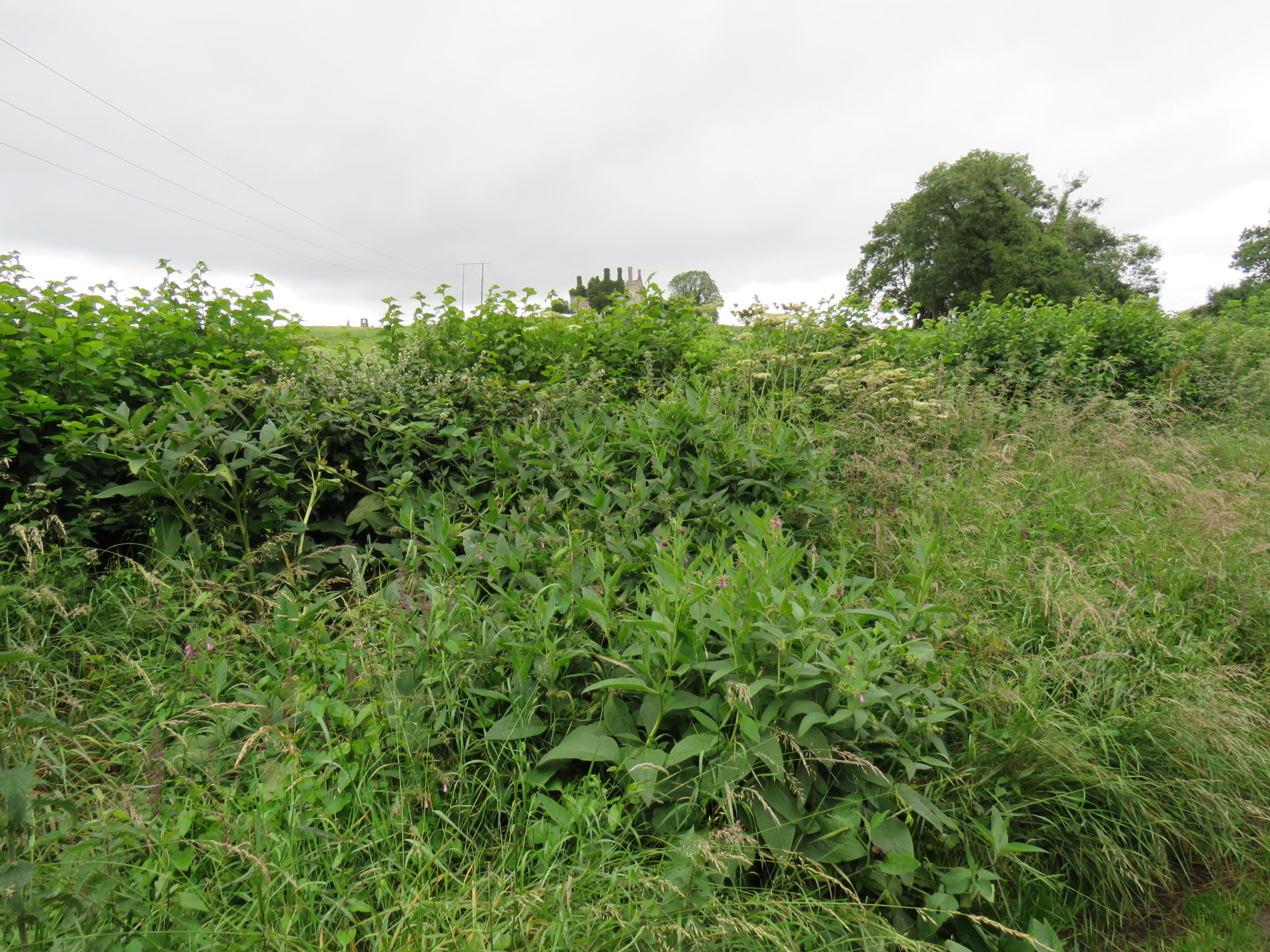
‘Sowing Seeds of Interdisciplinary Work’, the Castle Studies Trust funded project, showed how relict plants can deliver new insights into everyday life at medieval castles. Relict plants – understood to be the descendants of plants grown, cared for and used by (medieval) people – were identified through botanical surveys at four geographically diverse but culturally similar medieval castles: Adare, Co. Limerick, Castleroche, Co. Louth, Carbury, Co. Kildare and Castlecarra, Co. Mayo (as detailed in my previous blog post). As an initial step in researching relict plants, particular attention was paid to archaeophytes, those plants which arrived in Ireland pre-1500 CE. I believed that these plants may have participated in the various colonisation processes of the twelfth century. Their introduction could be linked to new gardening and other health practices especially those related to novel plant medicines which were emerging across Europe at this time but were perhaps previously unknown in Ireland.
Relict Plant Findings
Botanical surveys began during mid-2020 in the very wet months of June and July after a hot May.
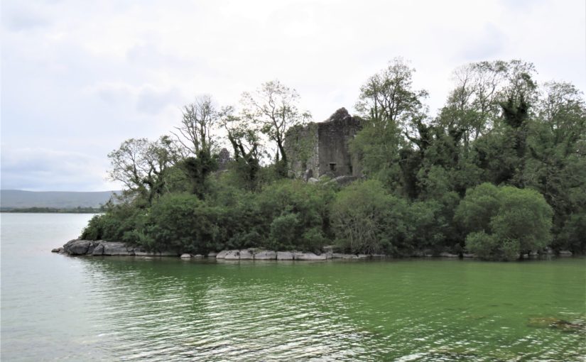
Next site on our Relict Plants project @CastleStudies is Castle Carra Co.Mayo. Built by Adam de Staunton c. 1240. Castle with hall and chamber, with the vill, parish church and abbey c. 1km east. pic.twitter.com/yJISGh7DiL
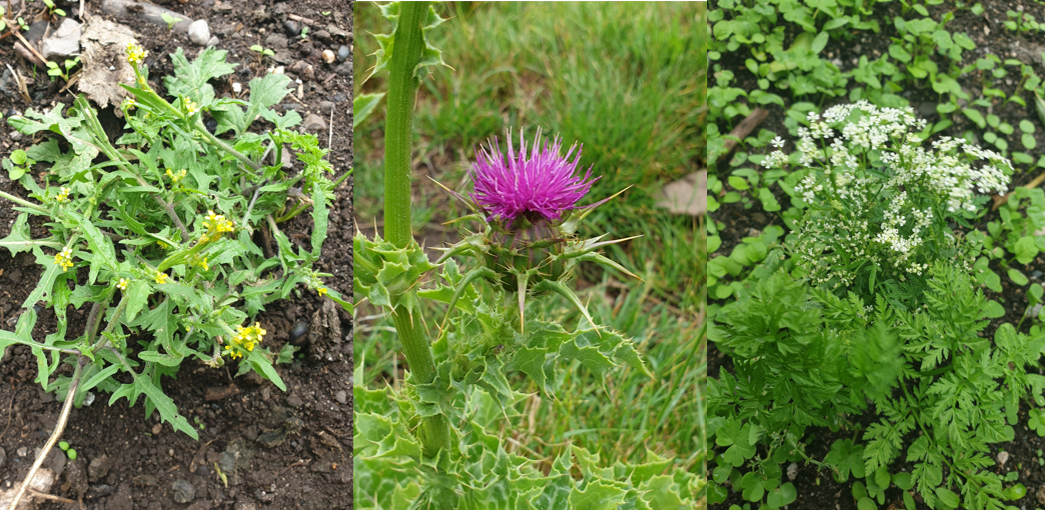
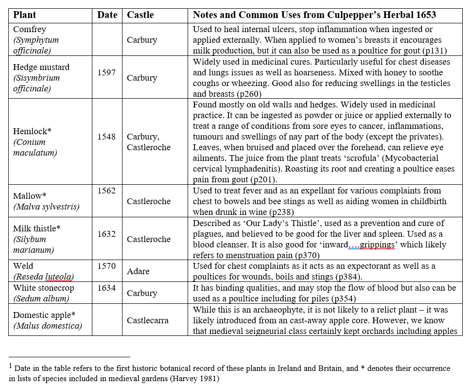
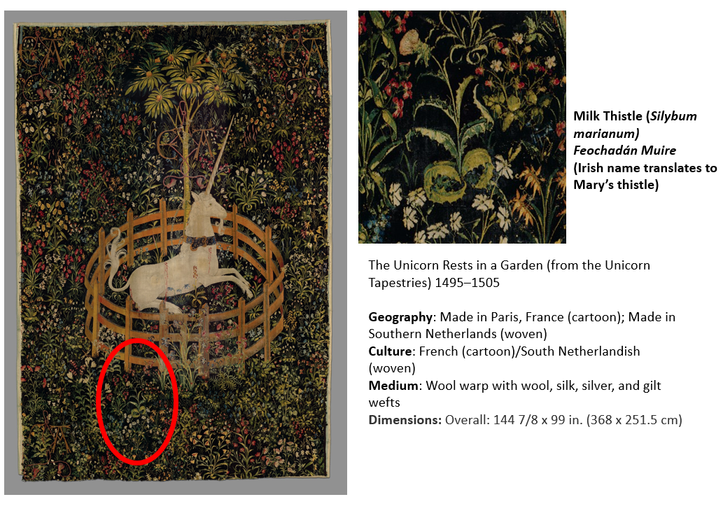
Over the course of the survey eight archaeophytes were revealed (Table 1) as well as a range of rare and common native plants. You can read Dr MacGowan’s botanical report here. These findings are significant: four of the eight plants were historically recorded as present in medieval gardens. The plants – comfrey, mallow, milk thistle and hedge mustard – are widely recognised as having medicinal properties (Fig 1). They feature in medieval recipes, continued as part of the tradition of plant medicine captured in Culpepper’s Herbal of 1653 and some, like milk thistle, remain in use today (see Table 1).
Figure 1 Milk thistle at Castleroche; Hedge mustard and Hemlock (Conium maculatum) at Carbury; (pictures by Dr MacGowan)
Table 1 List of Archaeophytes and neophytes at four selected castles in Ireland[1]
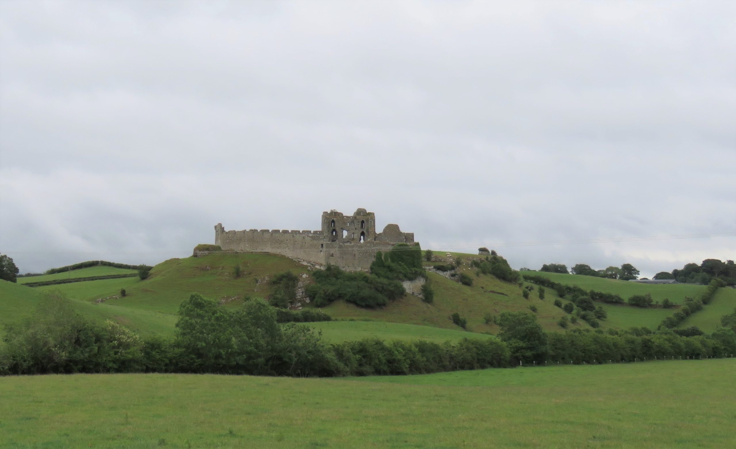
Figure 2 Castleroche, Co. Louth, sited for maximum spectacle across a locally significant elevation at the foothills of the Mourne Mountains
Relict Plants in their Castle Contexts
Castleroche was the first site surveyed for our fieldwork. It is spectacularly situated on a locally significant rocky outcrop, framed to the north by the foothills of the Mourne Mountains (Fig 2). The castle has been long understood as a defensive site, believed to have been positioned as authoritative infrastructure to exercise territorial control. Its’ patron, Roesia de Verdun (d.1247) is renowned as the only historically attested woman to have founded a castle in thirteenth-century Ireland This castle while now in ruins was once a busy place with an associated village replete with a weekly market and annual fair. I considered this site to have great potential for relict plants given that historic sources noted the presence of ‘gardinia’ (gardens associated with castles) coupled with the high-status of its’ patron who had a considerable number of estates across England and France. These connections must have given her and her staff access to, and knowledge of, different cultural traditions including gardening and medicinal practices. We were delighted to identify three archaeophytes: Hemlock (Conium maculatum), Mallow (Malva sylvestris) and Milk thistle (Silybum marianum). Milk thistle is a particularly important identification, it is very rare in Ireland and Britain. For medieval people, it was culturally and symbolically tied to the Virgin Mary as well as understandings of fertility and motherhood (Fig 3). This allows us to reconsider the idea of Castleroche only as a frontier site; perhaps there was a diverse resident population for much longer than previously understood. Their health concerns may be represented by the continued occurrence of these plants. Exploring the botanical legacy of Castleroche adds further layers to the story of this complex site.
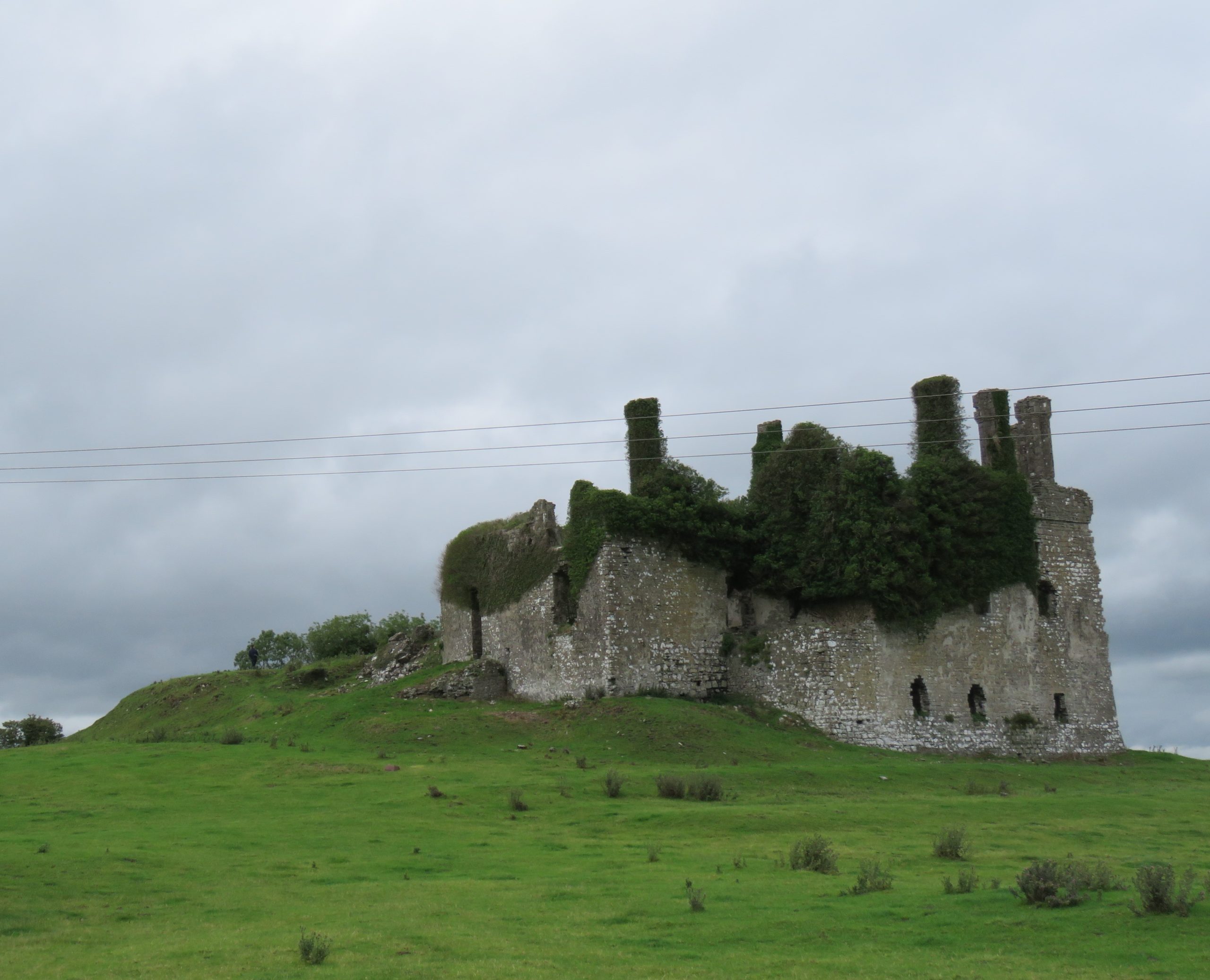
Figure 3 The Unicorn Rests in a Garden (from the Unicorn Tapestries) 1495–1505. https://www.metmuseum.org/art/collection/search/70007568Figure 4 Carbury, Co. Kildare: a multiperiod castle complex comprises a motte, an early masonry focal building with later additions including an Elizabethan extension crowned with multisided cut stone chimneys
A less well-known castle but equally deserving of attention is the medieval settlement at Carbury (Fig 4). This multiperiod complex comprises an earthwork castle, a twelfth or very early thirteenth-century masonry castle with later additions including an Elizabethan extension and related gardens (Fig 5). Carbury is entangled with generations of nobles. It acted as a central node in shifting political allegiances and dynastic disputes within the territory of Leinster. The longevity in occupation of Carbury is interesting, it attests – at least in part – to its suitability as a residence. Is this reflected in the immediate castle landscape? Is there a possibility that the early-modern gardens here overlay medieval predecessors? Four archaeophytes were found at Carbury: Hemlock, Comfrey (Symphytum officinale), Hedge mustard (Sisymbrium officinale) and White stonecrop (Sedum album), three of which were adjacent to or within the masonry castle and the fourth – Comfrey – which was found within the hedgerow that forms the historically significant boundary to the castle landscape (Fig 6). These plants are not uncommon, but perhaps their relative ubiquity is reflected in their suitability for use within different plant medicine traditions. Comfrey is particularly notable, known as knitbone, it was widely used as a healing poultice for broken bones throughout medieval medical texts. Pharmacologically, this plant contains allantoin, which promotes the creation of new cells and healing of connective tissue. Relict plant studies at Carbury allows us to reflect on how this place was a home to many different generations of people who participated in caring roles (for plants and people) whilst also being a locus for political tensions.
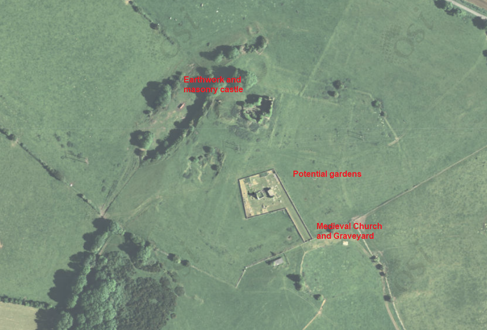
Figure 5 Aerial Imaging of Carbury Castle with evidence for potential gardens surrounding the castle.Figure 6 Comfrey (Symphytum officinale) and Hedge woundwort (Stachys sylvatica) noted among other medicinal plants in hedgerow with Carbury Castle in background
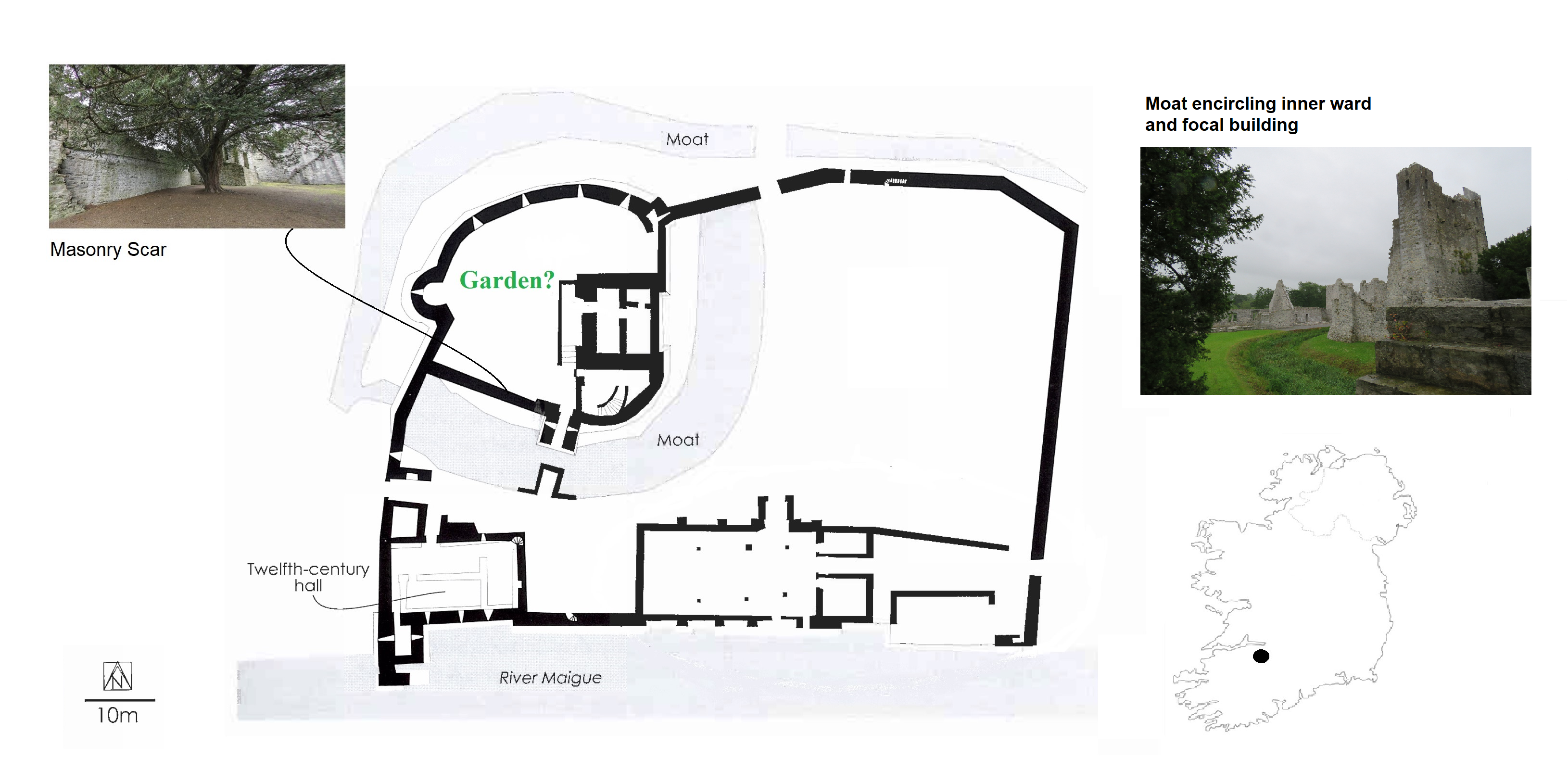
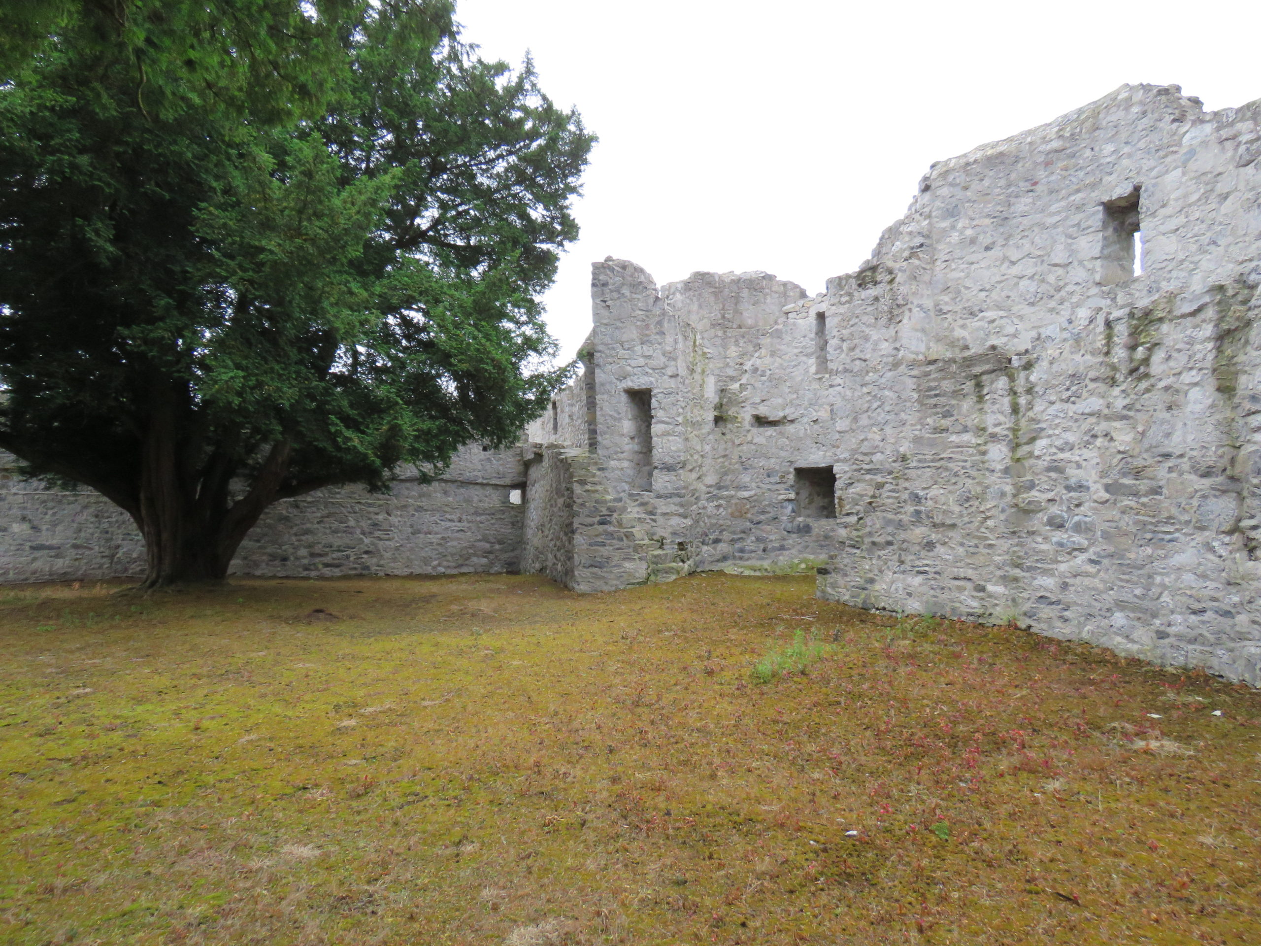
With these exciting discoveries at both Castleroche and Carbury, we were very hopeful that the survey at Adare Castle would be equally rewarding. Adare was an important castle as the caput of the Geraldine family. Unlike the other sites, it has been subject to major study including detailed historical and archaeological investigation. Adare Castle was constructed on a pre-Norman power centre from which the castle emerged as a large D-shaped earthwork with a surrounding large ditch and river-fed moat (Fig 7). This later formed the inner ward, which was further enclosed by an external wall to the north-west with a single mural tower and a gatehouse to the south. The outer court is enclosed by masonry walling which is augmented by a ditch to the north and west. At Adare, the grounds are intensely managed, with manicured lawns and ongoing pesticide use (Fig 8). Unfortunately, this was particularly pronounced in the inner ward, the area I have suggested was likely to have contained an enclosed garden. Disappointingly, only one archaeophyte was identified: Weld (Reseda luteola). This dyeplant was predominantly used to give a bright colourfast yellow but also used medicinally to treat chest complaints. A number of neophytes – those plants whose introduction post-dates 1500 CE – were found in the associated areas surrounding the castle as detailed by Dr MacGowan. Species such as Himalayan pheasant berry (Leycesteria formosa) were identified, indicating that relict plants studies can also illuminate the afterlife of the castle when it played a role as a romantic ruin in the eighteenth-century landscape of Adare Manor. This shows the potential for relict plants studies to add layers to castles stories across their life histories.
Figure 7 Plan of Adare Castle with possible garden (after Dempsey 2021 and O’Keeffe 2015)Figure 8 Adare Castle, inner ward subject to extensive pesticide use
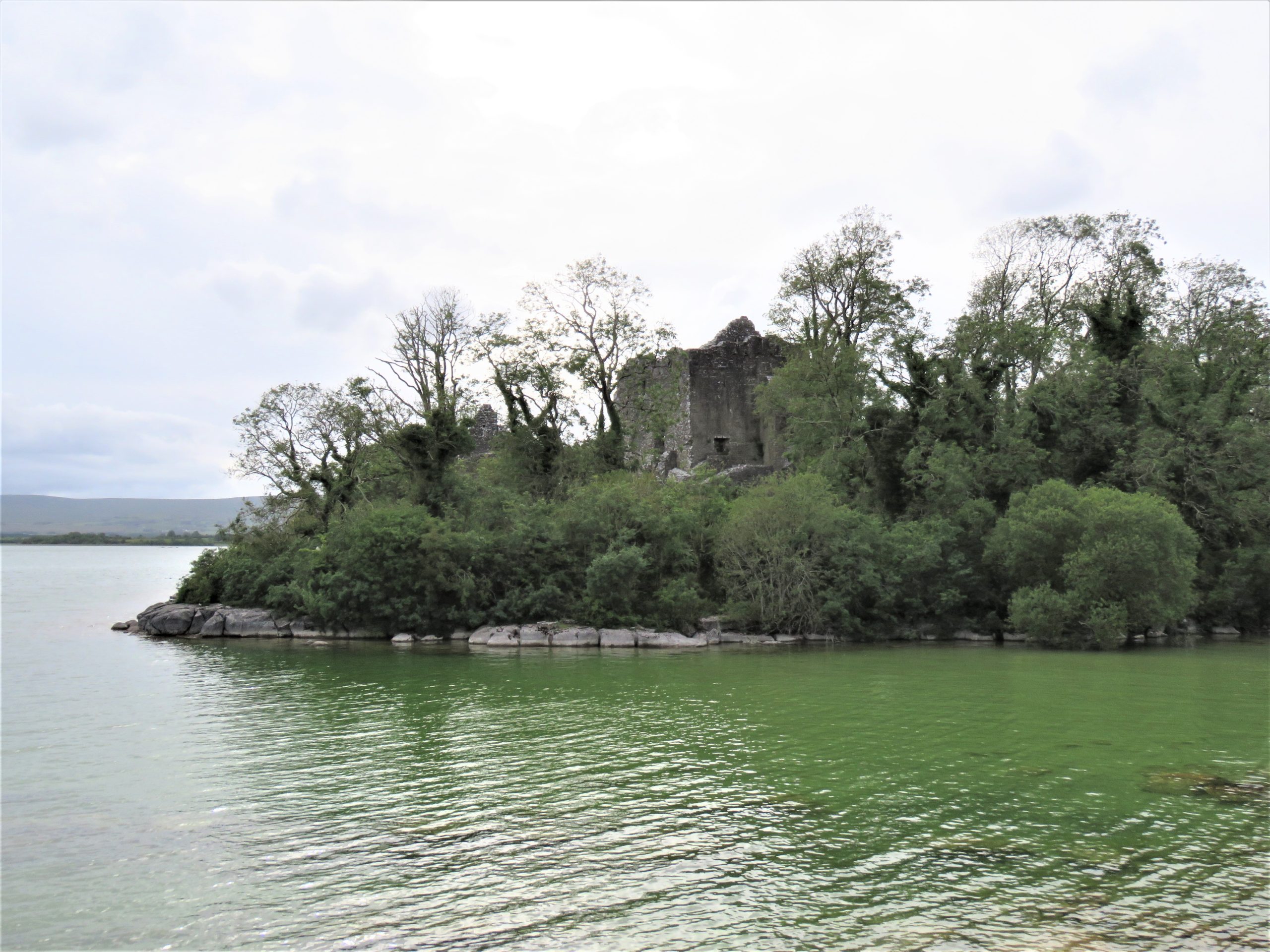
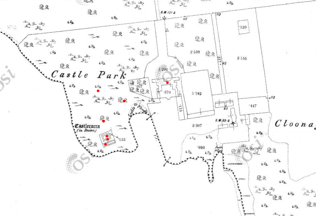
The final site, Castlecarra, falls lower down the social hierarchy of medieval Ireland than the other three castles but it was still an important baronial residence (Fig 9). It is situated on the eastern shore of Lough Carra. The castle now comprises a large three-storey focal building set within a very compact enclosure which is a later, potentially fifteenth-century addition. The castle was constructed as one part of the c. 1236 Anglo-Norman territorial expansion into Connacht. This site, like the others, has a long history of occupation. An early-modern (sixteenth-century?) house was constructed c. 125m NE of the castle, and the surrounding landscape appears to have been remodelled to suit a new tradition of landscape gardening which included a ha-ha and tree-lined avenue of Hornbeams (Carpinus betulus) (Fig 10). Archaeophytes were not recorded at Castlecarra but numerous native species as well as neophytes were present. This absence is remarkable but perhaps native plants at Castlecarra served the castle household needs. For example, Purging buckthorn (Rhamnus catharticus) was identified. This plant is native but rare in Ireland, and it was used medicinally as a purgative, as the name suggests. The botanical profile of Castlecarra leads to further questions around the transmission and sharing of medicinal and plant knowledge.
Figure 9: Castlecarra, Co. Mayo on shore of Lough CarraFigure 10 Castlecarra, Co. Mayo: a multiperiod site with medieval castle that forms part of the landscape of an early modern (c. later 16th / early 17th house). Ordnance Survey Map 1925, Castlecarra to lower left and historic home including outbuildings and gardens centrally placed. https://maps.archaeology.ie/HistoricEnvironment/
Research, Heritage Futures and Reflection
One of this project’s aims was to test and refine the methodologies of relict plant studies for medieval castles. In Ireland there are currently 96 species recorded as archaeophytes (but with no established dates of introduction). Despite the findings of some notable plants, the overall numbers of archaeophytes at the castle sites in ‘Sowing Seeds’ seemed low. Of course, our findings may have been constrained by single survey days, unseasonal weather as well as conservation and management issues – both present-day and historic. Future work is necessary. It is important that sites have the benefit of multiple visits across a wider seasonal survey period. Nevertheless, the baseline botanical surveys of this project will be of use for future research within and outside of castle studies. It has also revealed the need for a detailed survey of archaeobotanical evidence from excavations in Ireland to establish as far as possible exact introduction dates for particular plants.
Including a wider range of plants and castles over a longer time span would provide comparative material with a greater capacity to capture change over time. Neophytes were noted in the botanical surveys but not part of the research agenda for ‘Sowing Seeds’. Their occurrence at castle sites may be revealing of expanding connections with sixteenth-century colonising and trading practices beyond Europe. Later medieval towerhouses are of particular interest as they are often situated within less managed and therefore within potentially better-preserved landscapes. But equally, native plants should also be included. For example, self-heal (prunella vulgaris) and pellitory-of-the-wall (Parietaria judaica) occur widely and were both used as medicinally. It would be of great interest to compare and contrast different plants at castles whether native, anciently introduced or more recent. Consideration too could be given to the afterlives of medieval castles as romantic ruins as indicated at Castlecarra and Adare. This would develop a wider appreciation of the long lives of medieval castles that continue in dialogue with contemporary communities as heritage today. Relict plant studies enable castle studies to participate in emerging conversation around green heritage and climate change.
‘Sowing Seeds’ was a novel project – both conceptually and methodologically – I wanted to find a way to explore potential ‘green identities’ of castle households. Accessing the relationships medieval people may have had with their environments (as we might term it today) offers a different way of telling stories about the medieval past whose narratives are often caught into concerns of power, authority or control. By including botanical surveys of relict plants in castle landscapes, we have expanded further the multidisciplinary approach of castles studies. We can show how stories of castles are richly textured: populated by many people and plants over the course of their lives and beyond into their afterlives as romantic ruins and archaeological monuments. Doing this for the first time meant engaging with new material and unfamiliar sources from archaeology, history, and medical knowledge to heritage and folklore. This wide-reaching research methodology is a core strength of this project. It enables a dialogue between different disciplines that are traditionally separate or rarely integrated. These findings are a beginning: they encourage new avenues of future research on castles households relating to human-plant relations, plant medicine and related concepts of care. The results also invite conversations with heritage agencies regarding site management and conservation practices of both biodiversity and past vegetation. Rather than offering conclusive findings, we have revealed tantalising hints and a vast array of potential new avenues in which to take this research.
This research was generously funded by the Castle Studies Trust. Their support enabled new ideas to be explored. As an early career researcher being awarded a grant to undertake (potentially) interpretatively risky work is a wonderful opportunity.
Helpful commentary and feedback was received from two assessors whose insights improved this report.
Thanks to Dr Fiona MacGowan for participating in this research project and carrying-out the botanical surveys at the selected sites.
Thanks to the landowners of Castleroche, Castlecarra and Carbury, and the Office of Public Work who manage Adare, for access to the sites for this project.
[1] Dates in the table refer to the first historic botanical record of these plants in Ireland and Britain, and * denotes their occurrence in lists of species included in medieval gardens (Harvey 1981)
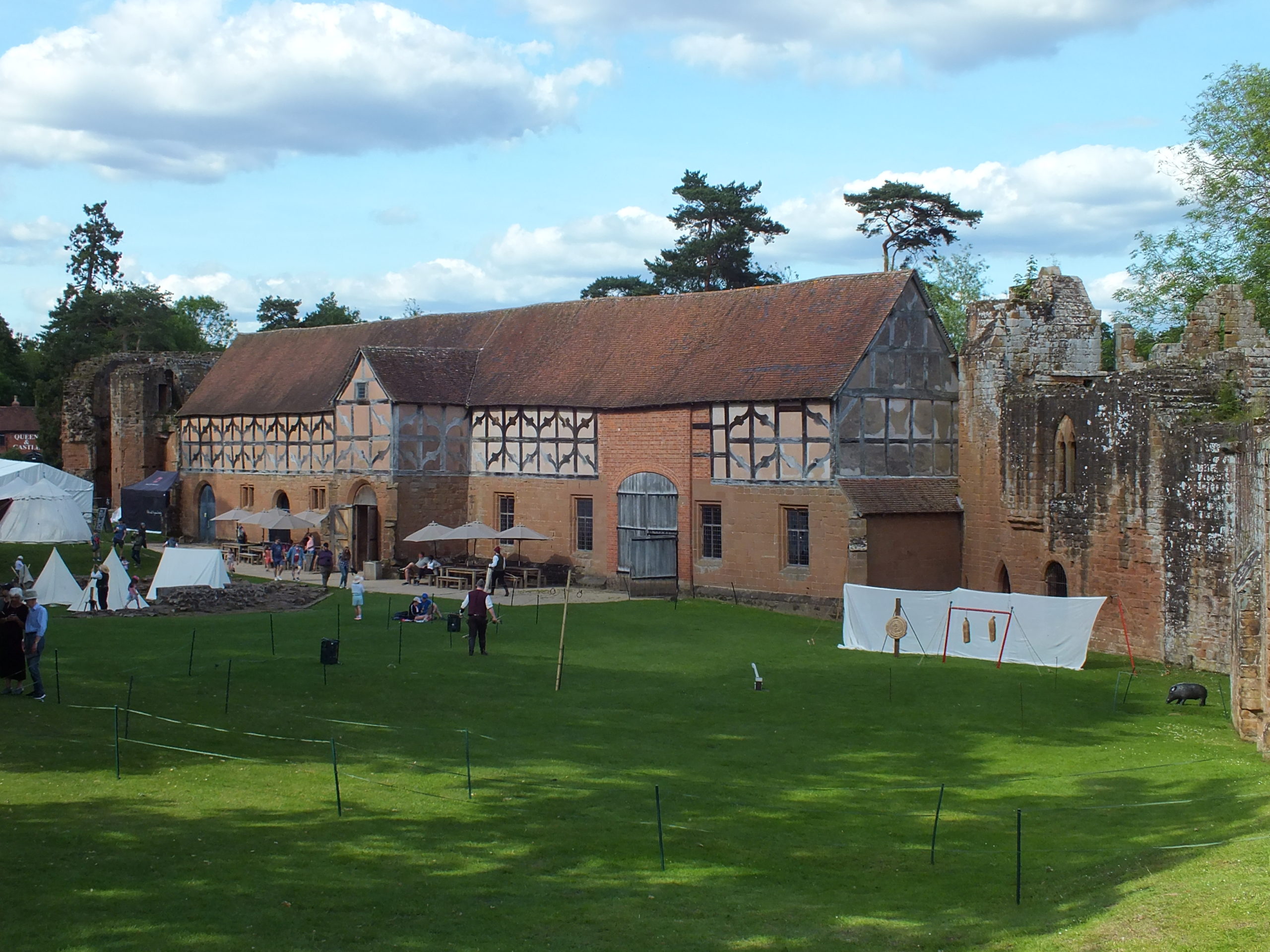
Castles were more than military sites, being political, judicial and economic centres too. Duncan Berryman of Queen’s University Belfast looks at one of those aspects, the important but little studied area of agricultural buildings in castles.
The domestic considerations of castles were as important to daily life as their defensive functions. Castles were also the centres of estates; Clare Castle (Suffolk) is a good example of an estate centre with manors in the surrounding region and further afield while Caister Castle (Norfolk) was the centre of a much more compact estate. Manorial centres were generally undefended courtyards of domestic and agricultural buildings. However, many of these were moated sites and their lack of defensibility might be debated. Sites such as Chalgrove (Oxfordshire) and Coolamurry (Wexford) had substantial moats and may have had complex bridges (Page et al. 2005; Fegan 2009). These complexes saw high-status accommodation sitting alongside the barns and animal housing that served as the manorial farmyard. Many smaller castles would have been the centres of smaller estates and would have also functioned as manorial centres. Agricultural buildings were vital to this operation and would have been found within baileys or associated enclosures. To investigate these buildings, it is essential to take a multidisciplinary approach by combining archaeology with documentary and pictorial evidence. The agricultural buildings have often been left unexcavated as they are seen as less important, and less interesting, than the domestic complexes.
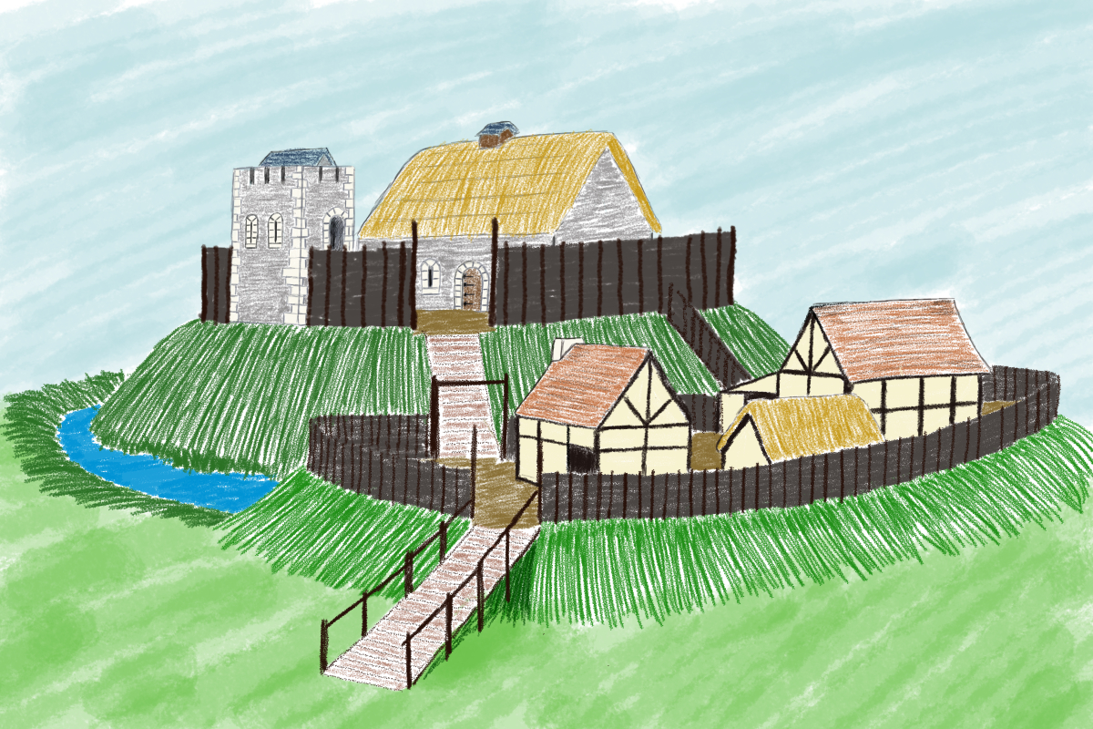
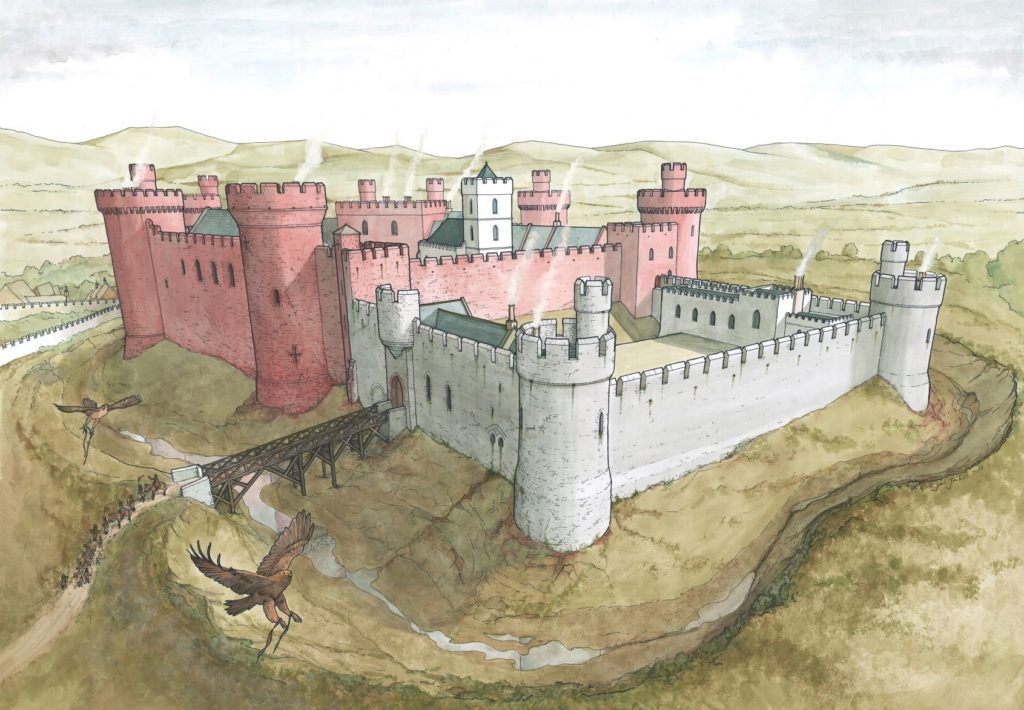
Artistic reconstruction of Clough Castle (Down). Many motte and baileys would have had a similar appearance, often with timber structures on the motte instead of the masonry buildings presented here.
Documentary sources related to Ireland indicate that many smaller castle sites had agricultural buildings within the surrounding area. This is clearly illustrated at Cloncurry (Kildare), where an extent records that beside the motte was “an old haggard close [farmyard] in which there are two small granges [barns] each of eight forks … [t]here is also there, beside the gate an ox-house … [and t]here is a dovecote” (Murphy & Potterton 2010, 175). There is also a record of a barn of ten forks at Castlemore (Carlow), as well as a mill and other timber and masonry buildings (O’Conor 1998, 32). The forks referred to in these accounts are probably the cruck blades of the barn, thus ten forks produce a nine-bay barn that could be the equivalent size of a barn like Bredon (Worcestershire). At Lough Merans (Kilkenny), the motte sat on a promontory in the lake and had an associated bailey containing a granary, stables, and a sheepcote (O’Conor 1998, 30). The motte of Inch (Tippararery) also had a granary and sheepcote, additional buildings were stables, a fish-house, a dovecote, and a malt kiln (O’Conor 998, 29). These examples suggest that, in Ireland, castles were playing important roles as the centres of manorial farms and wider estates. The perceived need for a defensive motte may have been carried over from an earlier period, but it continued with the construction of tower houses in the fifteenth and sixteenth centuries (McAlister 2019, 28-35).
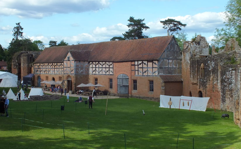
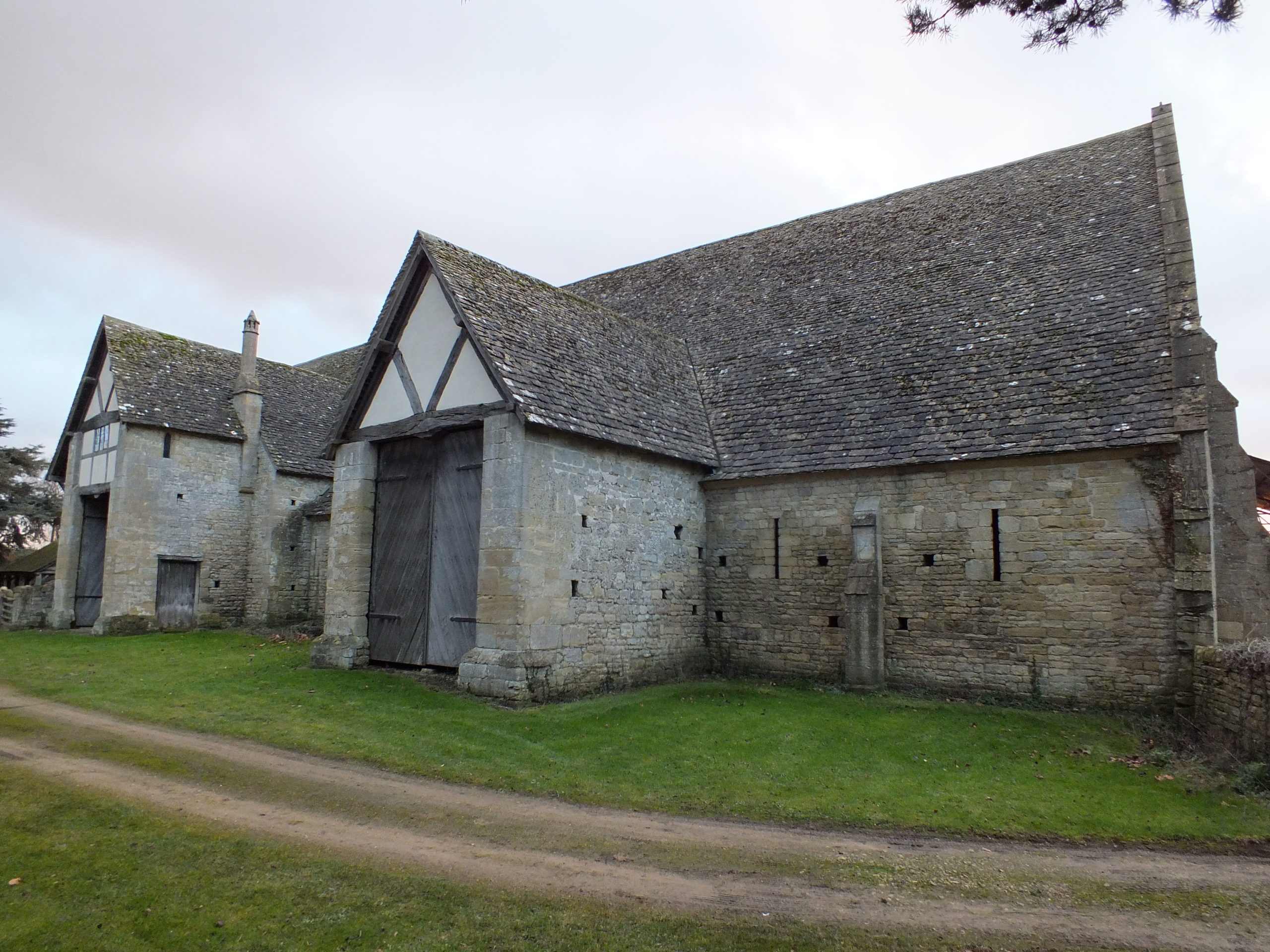
Bredon Barn (Worcestershire). Barns of a similar size were found within castle baileys. They would have been constructed from masonry or timber
A brief survey of larger castles in England does show that these castles had a small number of agricultural buildings. The main buildings identified were stables, dovecotes, barns, and granaries. These buildings are unlikely to have functioned in the same way as they did in rural manorial centres, but they are a reminder that some agricultural processes occurred within the castle. Stables were obviously for housing the riding horses of the lord or king and their entourage, but they probably also housed the cart horses used by the castle staff to bring goods in from the market. There are records of stables at Hereford, Leeds (Kent), Leicester, Lincoln, Nottingham, and the stables of Kenilworth (Warwickshire) are still extant (Colvin 1963). The dovecote was an important source of food in the form of squabs (young pigeons). A dovecote was recorded at Dorchester (Dorset) and one has been identified in the south-west tower of Bodiam (Sussex) (Colvin 1963; Thackray 2003). The existence of barns might suggest that sheaves of wheat or barley were being brought into the castle and threshed there, providing grain for flour and straw for the stables and other floors around the castle. There is evidence for barns at Acton Burnell (Shropshire), Bamburgh (Northumbria), Hadleigh (Essex), Weoley (Warwickshire), and Pontefract (Yorkshire) (Colvin 1963; Emery 2000; Roberts 2002).
The stables of Kenilworth castle (Warwickshire). This was a particularly grand building, but stables were vital for the lordly lifestyle.
The c.1610 plan of Castle Hedingham (Essex) indicates that there may have been an agricultural complex beside the main castle enclosure (Emery 2000, 113). To the top of the map are buildings labelled stable and barn and an area marked barnyard, in manorial sites this would indicate a complex of crop storage buildings including several barns and a granary. Returning to Clare Castle, the 1325 accounts of the constable indicate that there were a pigsty and poultry house within the castle compound (Ward 2014, 64).
Agricultural buildings are found in areas away from the main domestic complex of the castle, and these areas are often left unexcavated. They were most often made of timber, and thus leave little trace in the archaeology compared to the stone-built structures elsewhere. It is possible that there were more agricultural buildings within castles, or close to them, and they have not yet been identified. This research highlights the importance of using documentary and pictorial sources alongside archaeology and reminds us that lesser castle complexes may have been surrounded by a significant range of buildings.
Colvin, H.M. (ed.) 1963, The History of the King’s Works Vol I & II (London: Her Majesty’s Stationary Office).
Emery, A. 2000, Greater Medieval Houses of England and Wales II (Cambridge: Cambridge University Press).
Fegan, G. 2009, ‘Discovery and excavation of a medieval moated site at Coolamurry, C. Wexford’, in C. Corlett & M. Potterton (eds), Rural Settlement in Medieval Ireland in the Light of Recent Archaeological Excavations (Dublin: Wordwell Books).
McAlister, V. 2019, The Irish Tower House: Society, Economy and Environment c.1300–1650 (Manchester: Manchester University Press).
Murphy, M. & Potterton, M. 2010, The Dublin Region in the Middle Ages: Settlement, Land-Use and Economy (Dublin: Four Courts Press).
O’Conor, K.D. 1998, The Archaeology of Medieval Rural Settlement in Ireland (Dublin: The Discovery Programme).
Page, P., Atherton, K. & Hardy, A. 2005, Barentin’s Manor: Excavations of the moated manor at Harding’s Field, Chalgrove, Oxfordshire 1976–9 (Oxford: Oxford Archaeology Unit).
Roberts, I. 2002, Pontefract Castle: Archaeological Excavations 1982–86 (York: West Yorkshire Archaeology Service).
Thackray, D. 2003, Bodiam Castle (Swindon: The National Trust).
To help keep you entertained during this strange and hopefully unique Christmas the Castle Studies Trust has prepared a Christmas quiz. Can you name the castles these pictures are or images are taken from either our projects from all years or blog posts during the year?
The deadline for grant applications passed on 1 December. We’re going through the various projects now. Altogether the 14 projects, coming from all parts of Britain, one from Ireland, are asking for £88,000. They cover not only a wide period of history but also a wide range of topics.
In a little more detail here are the applications we’ve received:
Caerlaverock, Dumfriesshire: The aim is to understand the chronology and geography of extreme weather events in the high medieval period, and the effects they wrought on archaeological features that led to the abandonment of the old castle in favour of the new.
Georgian Castles: This project explores two castles in County Durham—Brancepeth and Raby—that were fundamentally reshaped and transformed in the eighteenth century to become notable homes in the area, and it advances not only our understanding of these two buildings in the period, but also the afterlife the castles in the area and the layers of history that they record.
Greasley, Nottinghamshire: The production of an interpretative phased floor plan for Greasley Castle in Nottinghamshire. The castle, built in the 1340s, has an obscure history and the understanding of its architectural phasing is at best very cloudy.
Laughton-en-le-Morthen, South Yorkshire: To provide professional illustration and reconstruction which will also be integrated into the co-authored academic article. Part of the monies will be used to produce phase plans of Laughton during key stages of its development, and a small percentage will pay for a line drawing of the grave cover.
Lost medieval landscapes, Ireland: To develop a low cost method, using drone and geophysical survey to identify native Irish (also termed Gaelic Irish) medieval landscapes and deserted settlements.
Mold, Flintshire, post excavation analysis: Post-excavation analysis from excavation on Bailey Hill of the castle
Mold, Flintshire, digital reconstruction: Visual CGI reconstruction of Mold Castle using the new-found evidence of further masonry on the inner bailey structure and using information gathered by the Bailey Hill Research Volunteers, showcasing the many changes that have happened on this site from a Motte and Bailey Castle to present time as a public park.
Old Wick, Caithness: Dendrochronological assessment of timber at the Castle of Old Wick, Caithness thought to be one of the earliest stone castles in Scotland.
Orford, Suffolk: recording the graffiti at the castle through a detailed photographic and RTI (Reflectance Transformation Imaging) survey will add to our understanding of how the building was constructed and the ways the building was used over time, particularly 1336-1805, during which the documentary history of the castle provides little evidence of how the site developed.
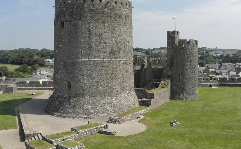
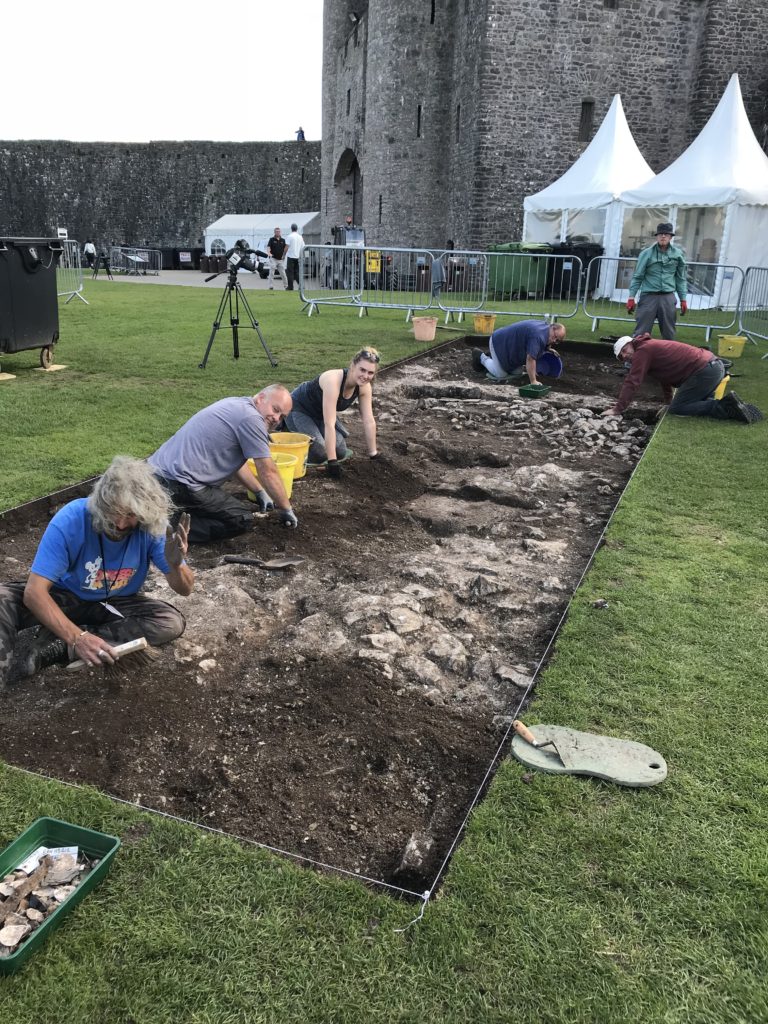
Pembroke, Pembrokeshire: A second season of trial-trench evaluation of the suggested late-medieval, double-winged hall-house in the outer ward at Pembroke Castle, which is of national significance. The evaluation builds on the results of the works undertaken through previous CST grants: geophysical survey (2016) and 2018 whereby two trenches were excavated across the possible mansion site. The evaluation will again establish the extent of stratified archaeological deposits that remain within the building, which was excavated during the 1930s.
Pevensey, East Sussex: GPR survey of the outer bailey and immediate extramural area and UAV (aerial) survey of the castle to build up a 3-D model of the site.
Richmond, North Yorkshire: Co-funding a 3 week excavation of Richmond Castle, one of the best preserved and least understood Norman castles in the UK. The aim is to understand better the remains of building and structures along the western side of the bailey.
Shootinglee Bastle, Peeblesshire: Funding post-excavation work from the 2019-20 excavation season in particular some charcoal deposits from a C16 burning event.
Warkworth, Northumberland: Geophysical survey to explore evidence for subsurface features in and around the field called St John’s Close in a field adjacent to the castle.
The applications have been sent to our assessors who will go over them and prepare their feedback for the Trustee’s who will meet in late January to decide on which grants to award.
In the Castle Studies Trust’s first year of grant awards it gave a grant to survey Ballintober Castle in County Roscommon, caput of the O’Conors. Project lead Niall Brady explains below how that work has been built on and what has been discovered since.
The Castle Studies Trust grant of 2014 for Ballintober Castle permitted a detailed baseline topographical survey of the 14th-century Anglo-Norman castle, constructed in the early 1300s by Richard de Burgh, earl of Ulster, and taken over by the O’Conor kings of the Connacht before the end of the century, after which it became the caput of the O’Conor Don line and was lived in continuously until the O’Conors abandoned the castle for more suitable accommodation at nearby Clonalis House in the 1700s.
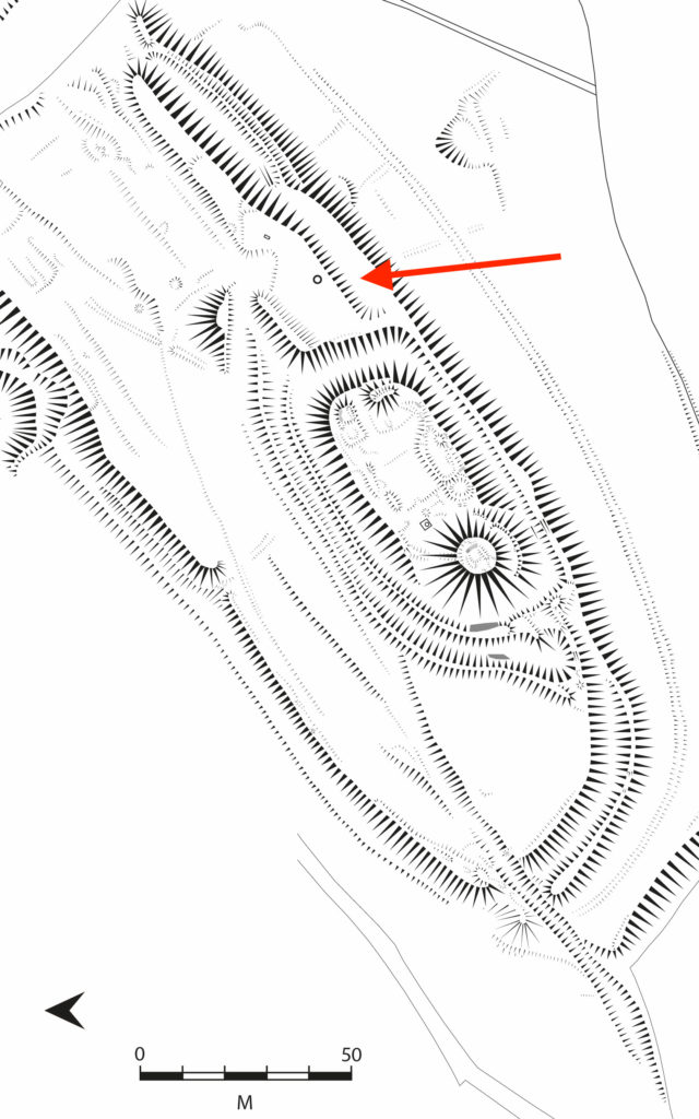
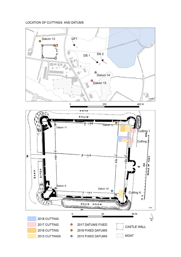
Location of excavation cuttings 2015-2018, by Dan Cearley
The castle remains a striking ruin in the small village of Ballintober and access to the site is prohibited because of its dilapidation. The 2014 survey feeds into a long-term plan by the O’Conors who retain ownership to rehabilitate the site so that it can be accessible once again and enjoyed. Since 2015, the Castles in Communities research fieldschool has taken a leading role in developing this initiative as a community-engaged anthropological and archaeological Summer fieldschool that sees groups of up to 70 students and staff coming over from America in July, working closely with the O’Conors in Clonalis House and the village represented by the Ballintubber Tidy Towns organization. Additional survey, coupled with geophysical survey, field survey and excavation has made great strides in revealing the complex history of the castle, while a conservation management plan for the castle was completed independently in 2016.
The fieldschool’s work has also extended outside the standing walls of the castle. In reaching eastwards across the present-day village, the project has confirmed the presence of a deserted settlement that would have been integrally related to the castle. In short, Castles in Communities has revealed the deserted manorial village that was associated with the castle and the findings indicate that the medieval settlement footprint was fully twice the size of the present-day village. Excavation within the deserted settlement area is focusing on taking cross-sections across former property plots and the houses within.
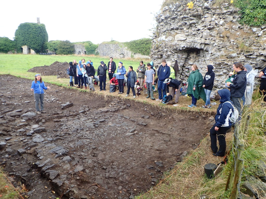
Photograph of cutting opened along the castle entrance in 2019, where evidence for two principal phases of construction have been identified. Siobhan Boyd, project director, explaining the findings.
Excavation inside the castle has progressed along the east side of the interior, where perimeter walls are lower and there is no risk of destabilizing standing remains. Attention has focused on the corner towers, and the perimeter wall. The southeast corner tower is circular in plan but its interior was robbed-out at some point in the past, leaving only a narrow and thin occupation deposit that retained post-medieval ceramics. The northeast corner tower is rectangular in shape, and excavation revealed a large building joined to the tower and running south from it. That building is late in the construction sequence and is itself joined to an earlier masonry structure that lies inside the walled perimeter. The indications for an early phase of castle building that might pre-date much of the standing perimeter walls is also indicated at the castle entrance, where excavation has begun to reveal two distinct phases of construction.