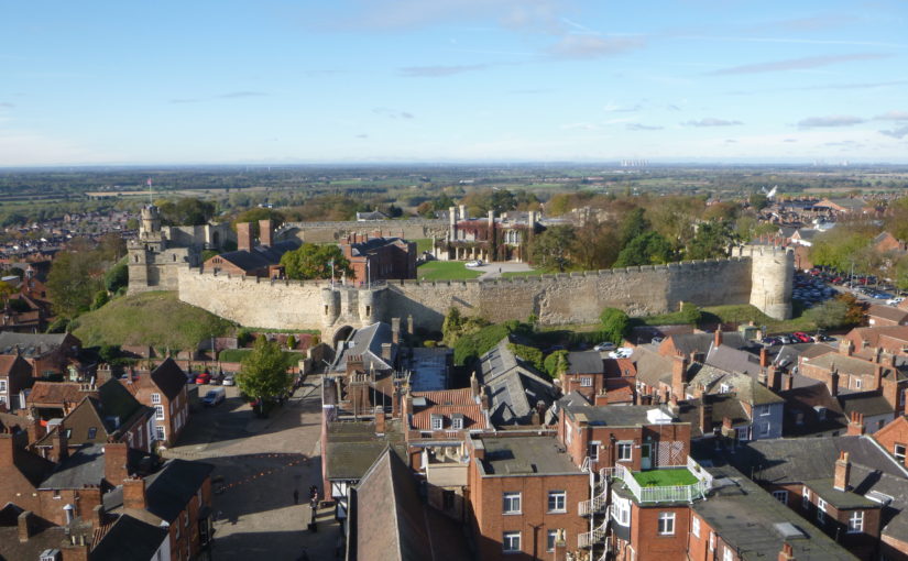
Dr Michael Fradley, project lead for the CST funded project on Caus Castle in Shropshire examines one of the main interesting aspects of the project.
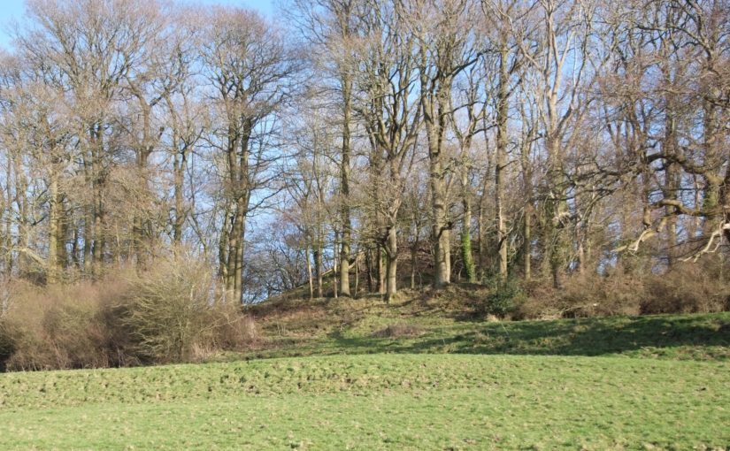
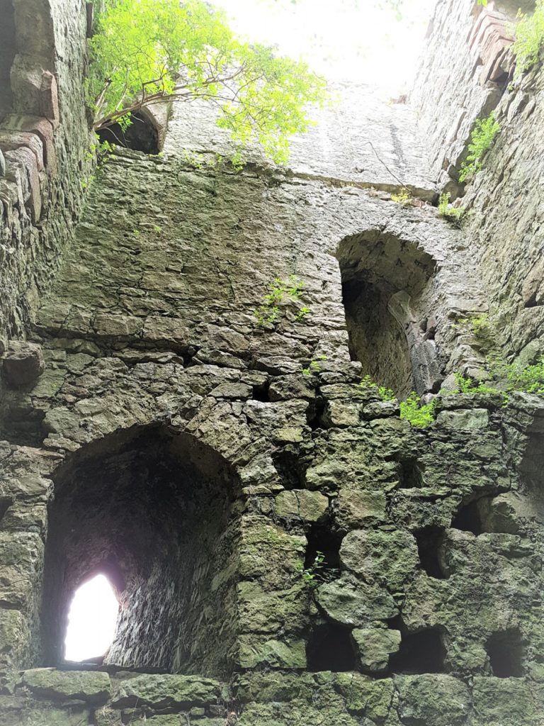
Looking back on our work at Caus Castle in Shropshire, funded by the Castle Studies Trust, one of the most interesting elements identified was the post-medieval redevelopment of the site. Given how little field research had taken place prior to our work in 2016, there were many new observations to be made, but the creation of ornamental gardens on the south slopes of the hill hinted at ambitions to develop a new elite landscape.
At its medieval height, the Corbet family had constructed an extensive castle complex, with views from the motte, great hall and southern wing of the castle bailey looking out across the wide Rea Valley to their hunting forests of the Stiperstone Hills. While these views would still have been important, archaeologically we can see a shift in investment into creating an immediate garden landscape on the sunny, southern-facing slopes of the castle. The shift away from the monumental defences that defined the medieval castle is demonstrated physically through the infilling of the southern ditch of the castle bailey to create a probable broad planting terrace (Fig 1). It seems probable that this process of creating an ornamental landscape at Caus began in the 16th or earlier 17th century, possibly under the Staffords, or more likely under Joan Thynne and her son Thomas.
Figure 1
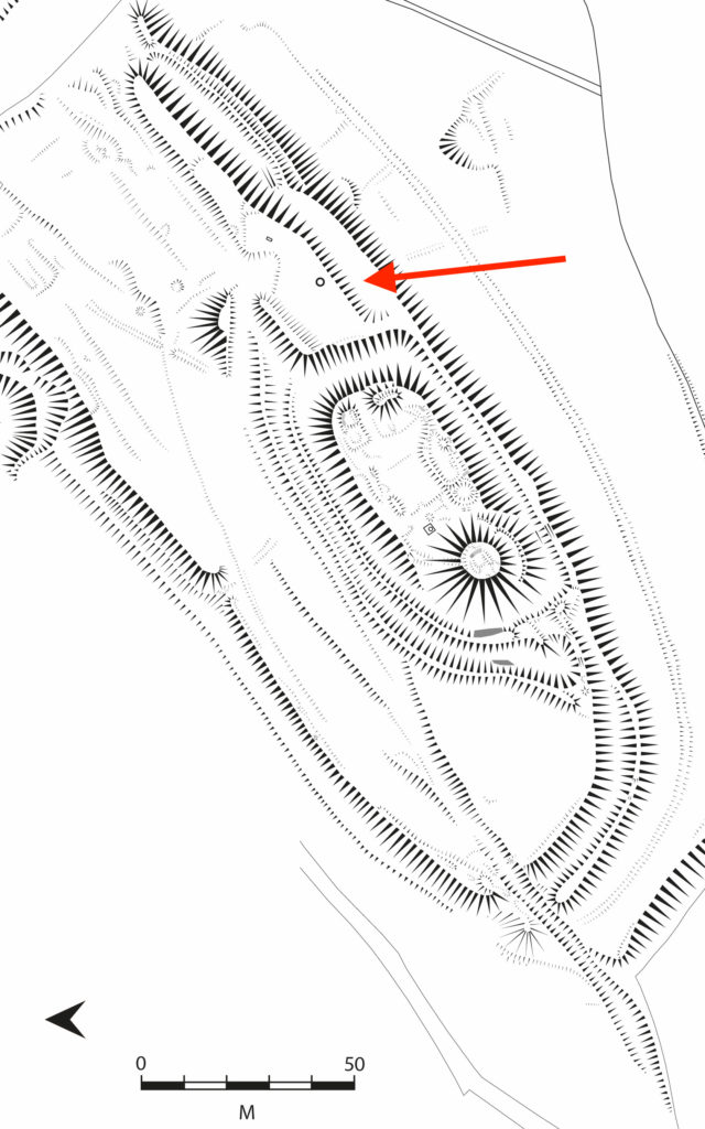
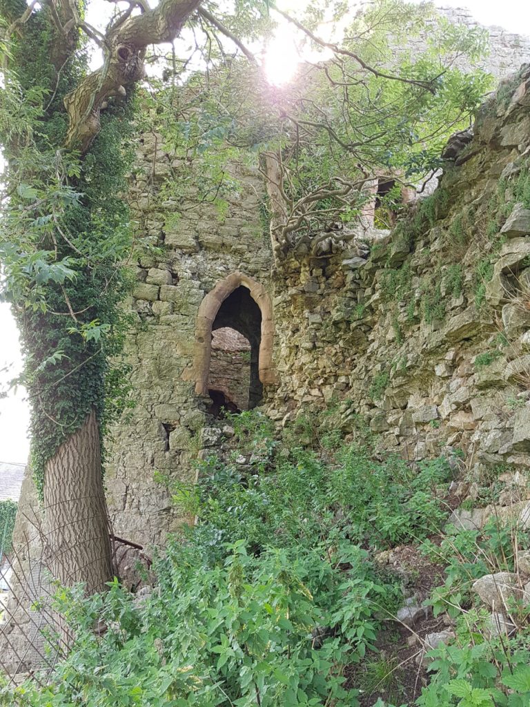
The use of a digital photogrammetric model of the castle, using imagery collected by a drone-mounted camera, proved invaluable in this stage in identifying that further garden features may have extended further south beyond the original bounds of the castle. A square enclosure, fragments of which had been picked up by the ground topographical survey, was clearly visible on the digital model on the southern slopes (Fig 2). While less clear in function than the garden terrace, this feature would also seem to fit within an expanding garden complex.
Figure 2
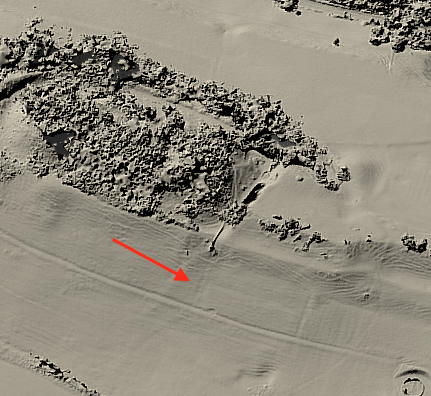
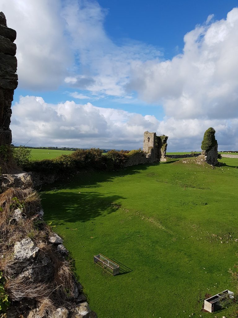
While the totality of these garden features would seem small in comparison to earlier and contemporary examples of elite gardens developed around castle sites, as well as former monastic complexes and new country houses, Caus Castle was not a central residence of the Thynne family, which centred on Longleat in Wiltshire, and should also be seen potentially as a work-in-progress as a developing ornamental landscape. If investment had continued at Caus as an elite residence, we could perhaps draw a broad analogy with the development of Powis Castle in terms of a castle revival in the 17th century, in a geographically peripheral location that ornamentally made full use of its south-facing slopes (Fig 3).
Figure 3
Elite investment in Caus Castle appears to have ended in the 17th century, and while we are deprived of seeing what it may have become if it an been maintained as an elite residence and associated landscape, that development would have potentially destroyed much of the evidence of the medieval and earlier evidence. This snapshot of a castle in flux in the earlier post-medieval period does, however, make the site that little bit richer archaeologically.
In its latest round of grants the Castle Studies Trust funded an ambitious 3-D reconstruction of the 12th-century form of Lincoln Castle. Project lead, Jonathan Clark, explains the background to and aims of the project.
Lincoln Castle is one of England’s great castle complexes, developed during an initial intense period of use which straddles the Conquest through to the first half of the 13th century. The reconstruction builds on the work of the recent Lincoln Castle Revealed project, which involved the conservation and repair of the castle fabric and bailey buildings, the creation of a new exhibition space, and provided a wealth of opportunities for research-led archaeology. The results of the archaeological campaign – which encountered remains from every century from the 1st to the 20th – have greatly enriched the story of the site as a whole.
Archaeological investigations encountered elements of the Roman fortress and later Roman Upper City, the defensive enclosures of which appear to have shaped future land-use patterns well into the medieval period, including the form of the castle. The west and south Roman walls stood long into the medieval period; indeed, parts of the western defences still stand to the south of the west castle wall. The southwestern corner of the Roman fortress provided the western and southern extent of the castle bailey.
Surveying the Observatory Tower. While the current external appearance of this tower is entirely due to changes in the 1830s, the interior fabric still retains important evidence as to its earlier form.
The main development of the castle in stone appears to be from the 1080s into the mid 12th century, a period which will be captured by the reconstruction. This campaign of work included the construction of East and West Gates, the stone enclosure of the bailey, the 12th-century Lucy Tower shell keep, the development of internal ranges against east and west curtain walls, adjacent to the gates, and a hitherto unknown South Gate. The South Gate position has been identified in the fabric of the south curtain wall, while its appearance has been confirmed by an early draft plan of Lincoln by John Speed, dated to 1607.
The Lucy Tower Motte after the removal of dense vegetation. The fragmentary masonry remains of a structure can be seen towards the top of the trench.
The investigations also provided valuable new information about the form and development of the main shell keep (the Lucy Tower) and the southeastern tower (known from the early 19th century onwards as the Observatory Tower). The Observatory Tower, which briefly upstaged the Lucy Tower during the Anarchy years of the early 12th century, was originally detached from the rest of the castle bailey by a substantial ditch. This ditch featured a stone revetment on the tower side which was carried up to encase the lower part of the mound on which the tower sits. The tower was subsequently remodelled to serve as gaol tower. More is now known of the Lucy Tower including the form of the roof, openings and the arrangement of rectangular chamber blocks, or turrets, to the east and west of it.
A segment of the interior wall face of the Lucy Tower. The small sockets are putlog holes, while the large blocked sockets housed timbers that joined with a timber ring-beam.
The remains of the main castle hall and various service buildings were also investigated as part of the Lincoln Castle Revealed project. Their positions are now accurately plotted within the castle bailey and these buildings are being added to the 3-D reconstruction.
A book on the archaeological discoveries from the project is forthcoming but the 3-D reconstruction will allow all to visualise an explore Lincoln Castle at its zenith. The reconstruction is being prepared by Pighill Archaeological Illustration advised by the Lincoln Castle Revealed archaeological team.
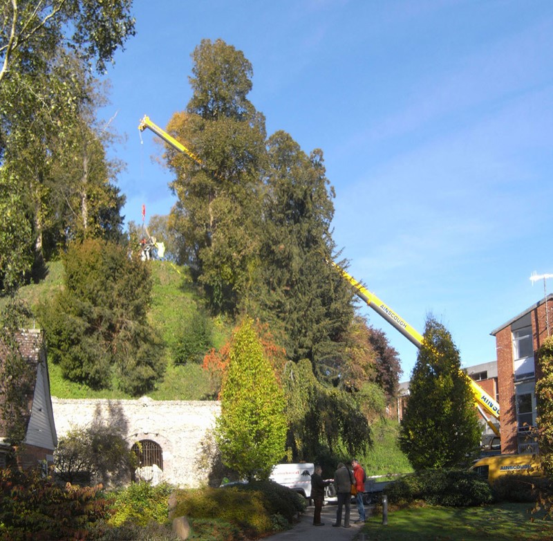
Over the last two decades, the Marlborough Mound Trust has carried out extensive conservation and investigations on the ‘mound’ in the grounds of Marlborough College. The origins of the mound were uncertain until recently. It was known to have been part of Marlborough Castle, but there had been persistent speculation, on the strength of its resemblance to neighbouring Silbury Hill and the discovery of antlers in the early twentieth century (now lost) that it was of prehistoric origin. In 2008, when Silbury Hill was being investigated, the opportunity of taking cores from the mound to obtain comparative dates presented itself. After a precarious operation involving a very large crane, the necessary drilling rig was hoisted to the top of the mound. The resulting cores, as a paper published the following year by Jim Leary and his colleagues showed, supported a date in the second half of the third millennium BC, broadly contemporary with Silbury Hill.
The drilling rig for the coring operation is hoisted into place (copyright Marlborough Mound Trust)
Jim Leary has subsequently carried out a survey of some fifty castle mottes, looking for other sites where prehistoric mounds could have been reused as the base for a castle, and has found only one other rather uncertain case. This means that Marlborough may be unique in being a prehistoric structure recycled into a medieval castle.
But we now know more about the prehistory of the mound than the supposed castle keep. The only possible sighting of masonry on the mound is uncertain in the extreme. H. C. Brentnall, a master at Marlborough College, in one of his many contributions to the Proceedings of the College’s Natural History Society on the the history of the castle, had this to say in 1936:
“Excavations necessitated by building operations at Marlborough College in the course of this summer have revealed several traces of the medieval castle which perished gradually between the fifteenth and seventeenth centuries. What little remains above ground (if the elevation justifies that expression) is to be seen on the summit of the motte, where a buttress of the keep was laid bare some years ago.“
The note implies that the buttress was visible in 1936, but recent geophysical surveys have not found it.
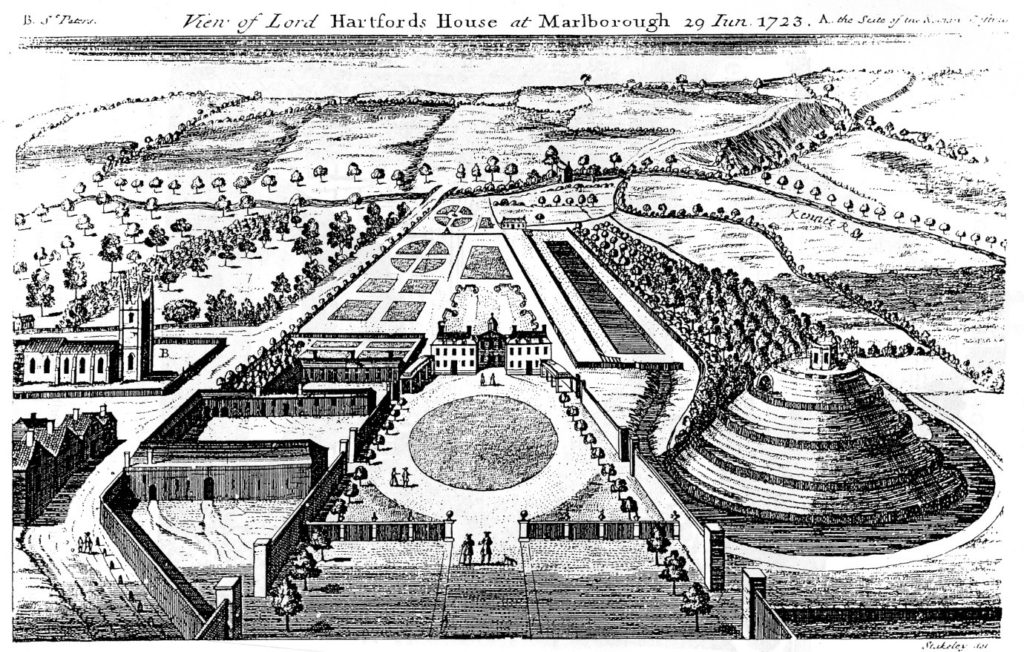
The problem is further compounded by the subsequent use of the mound. It became a garden feature in the seventeenth century, and a spiral was cut into the side of it to give access to a summerhouse at the top. Stukeley’s engraving of the countess of Hertford’s gardens in 1723 shows only the summerhouse, and no traces of masonry.
Stuckley’s engraving of countess of Hertford’s gardens.
About the same time, a water tank was installed to supply the Hertfords’ newly built mansion. This was enlarged by the College after its establishment in 1843, and adapted over the years, until the top of the mound was graced by a large iron tank surrounded by a spoil bank, concrete steps, and substantial pipework. This meant that in effect most of the original top of the mound had been destroyed.
This raises the question of what we are looking for. The earliest mentions of the site, in 1070 and 1110, present the king’s establishment as a place of imprisonment and a site where a royal court was held. In the 1140s, Marlborough castle is first mentioned as such. It is described ‘very defensible’ in The Deeds of King Stephen. It was held by John Marshal, who used it to control the surrounding countryside, and there is no record of it ever being attacked.
The only entry in the plentiful records for the castle under Henry II and Henry III is in the context of payments in 1222 for work designed to create a substantial royal residence there. This is a single sum for the building of a lime kiln ‘for the Great Tower’, which must therefore have been of stone. There is no indication where this tower was sited, and it may well have been part of the lower bailey. It has simply been assumed that it was on the mound.
An inconclusive exploratory dig was carried out by Wessex Archaeology for the Mound Trust in 2019, and at the time of writing, it is still hoped that a follow up to this will be possible in 2020. The present assumption is that the mound was among the hastily erected timber forts from immediately after the Norman conquest, and that this was replaced by a stone keep after 1222. It would be good to be able to find some actual evidence as to the nature and even the existence of the keep at Marlborough.
Richard Barber is a trustee of the Marlborough Mound. He would welcome any comments, particularly on the replacement of timber with stone, and the nature of ‘great towers’: email rwbarberuk at yahoo.co.uk.
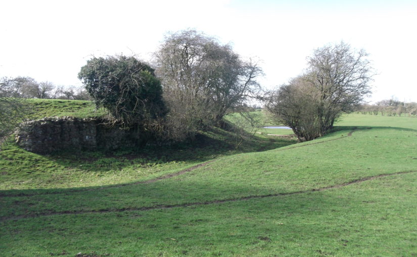
The earthwork site at Kirkby Fleetham just to the east of the A1 near Bedale in North Yorkshire is generally taken to be the hunting lodge given a licence to crenellate for Henry Le Scrope in 1308. However, recent finds in an adjacent domestic garden together with a reappraisal of the surviving documentary evidence give a more nuanced picture of life at the site.
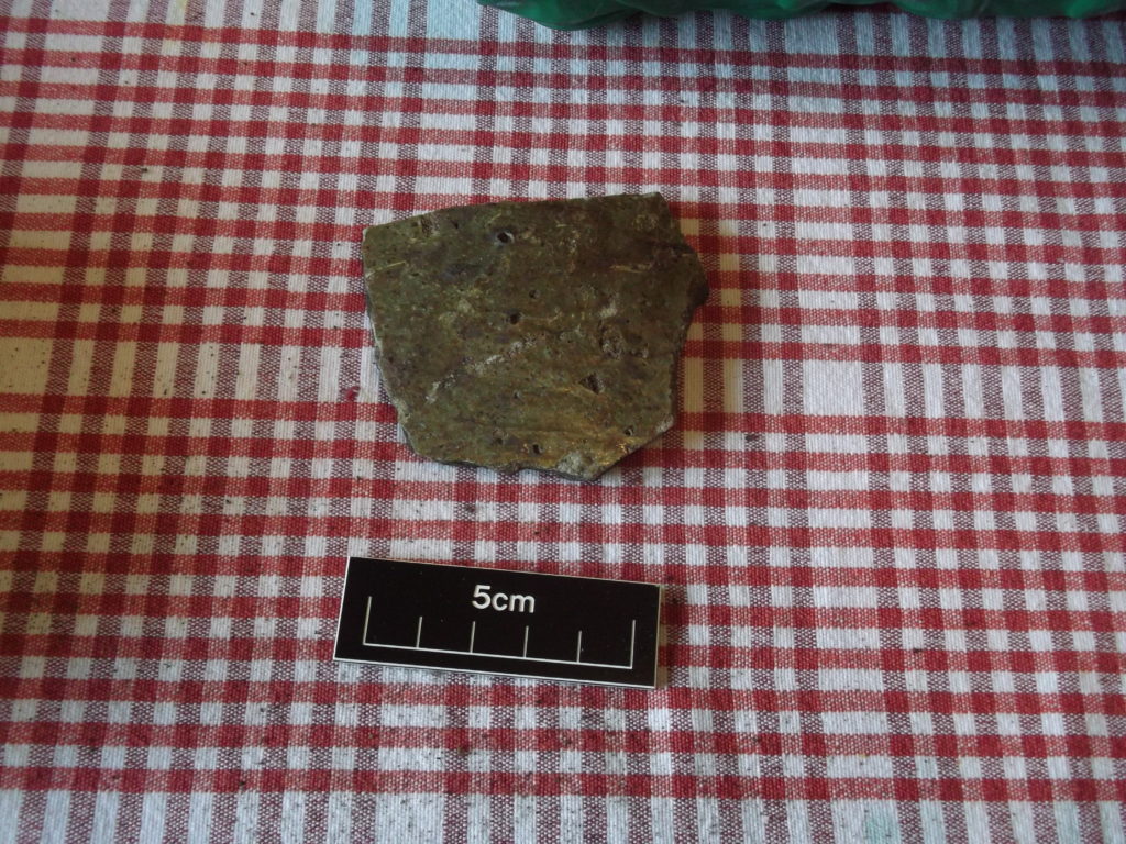
Work in the garden of a house directly to the north east in Spring 2019 has located the foundations of a coursed rubble stone wall approximately 1.3 metres wide with a series of looped windows, an internal mortar floor and traces of external white rendering. Traces of a cobbled yard have also been identified running between it and the castle earthworks to the south west. It has yielded a range of pottery including body sherds from Humberware jugs of the 14th Century along with several sherds of Cistercian ware from the early 16th Century. What is also significant is the volume of material dating to the Late 11th/12th Century including Coarse Sandy Gritty Wares from the York Area.
C14 Humberware Pottery
In terms of the castle remains two sections of stone revetment for a moat survive otherwise the site consists of two earthwork enclosures one slightly higher than the other surrounded by the drained site of two large artificial lakes running to the west and north west. The unseasonable dry weather in Spring 2020 allowed for a number of clear stone building platforms to appear marked in the vegetation. These suggest a peripheral curtain wall surrounding the inner mound with a series of buildings leading off it. Erosion by rabbits in the outer enclosure reveals a series of cobbled surfaces with sherds of pottery from further south in the Vale of York dating from the 12th through to the 14th Centuries. A series of building platforms clearly track off into neighbouring gardens including the one where the recent discoveries have been made.
Wall excavated in garden next to Kirby Fleetham castle
The documented history of the site together with the surviving pottery suggests a much longer period of occupation than has previously been suggested. The Domesday Book tenant is referred to as Odo the Chamberlain of the Duke of Brittany with references to his former holding throughout the documentary record in the 12th Century. In the mid to late 13th Century the owner is referred to as Sir Henry Fitz Conan who had a licence for a park awarded in 1271. The decline of the site is poorly documented although there is evidence of continued occupation into the early 16th Century and the documents show it held as a hunting lodge by Lord Grey of Codnor in 1417 when the estate was briefly forfeited by the Scropes.
In terms of the building in the adjacent garden, its design and location suggest a half-timbered superstructure above a stone basement and from its location a court house or similar use such as survives at Danby in the North York Moors can be hypothesised.
For more information about the excavation please contact Erik Matthews on rubyna dot matthews at btinternet dot com
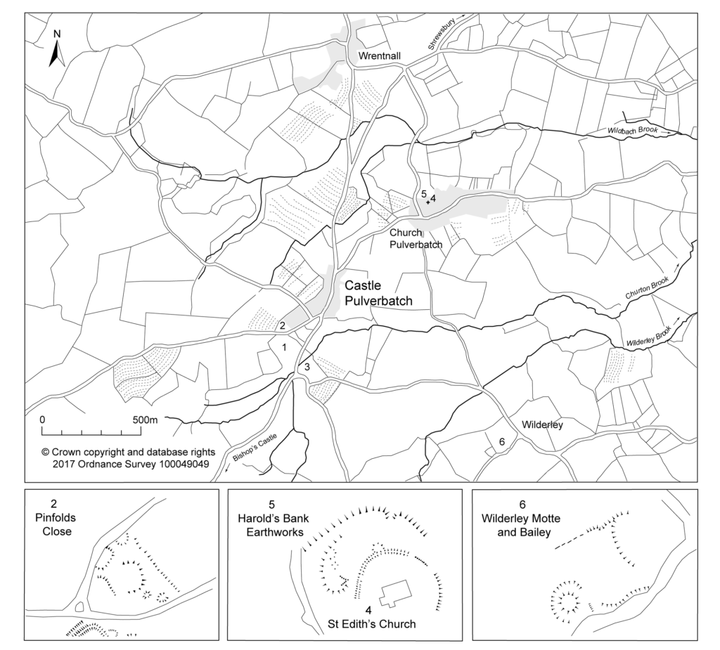
Giles Carey project lead for the Castle Pulverbatch survey, funded by the Castle Studies Trust, presents an overview of the wider settlement context for the motte and bailey at Castle Pulverbatch, central Shropshire.
“It is a truism that medieval castles ‘dominated’ their landscapes. But this apparently simple statement obscures, and indeed misrepresents the many and varied ways in which castles were both embedded in the medieval landscape and contributed to its evolution and character.” (Creighton and Higham, 2004: 5).
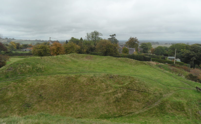
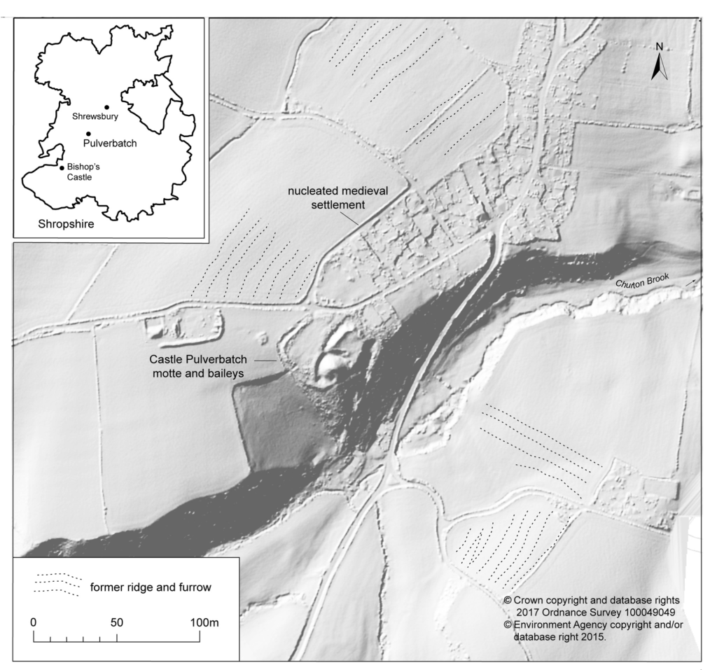
Pulverbatch is a village situated in central Shropshire, about 13km southwest of Shrewsbury on a minor road from Shrewsbury to Wentnor. The modern village is formed of two distinct centres, with a small nucleated settlement around the church (Church Pulverbatch, known as ‘Churcheton’, then Churton since at least the 13th century (Gaydon, 1968: 138)), and Castle Pulverbatch lying c.1km to the SW. One of Shropshire’s best-preserved motte and bailey castles is situated on the edge of a small steep-sided ridge at the southern end of the village (figure 1).
The castle comprises a roughly circular motte, with a base diameter of 35m standing up to 8m high, constructed on the edge of a ridge to make the best use of the natural topography. A substantial ditch 7m wide and 2.6m wide, with a counterscarp bank 4m wide and 0.8m high, separates the castle motte from the flat ground to the west. The inner bailey, situated to the north-east of the motte, is roughly rectangular in plan. It measures 28m north-east to south-west by 30m south-east to north-west. Around its north-west and north-east sides, the bailey is defended by a substantial bank up to 10m wide and 4.2m high on its outside, 1.5m high on its inside. The south-east side of the inner bailey is not defined by a bank but makes strategic use of the natural topography to provide a defendable location. The outer bailey, standing to the west, is, by contrast, defined by much slighter defences. This difference in construction has been suggested as indicating a two-phase construction for the site, with the outer bailey representing the enlargement of a compact and strongly defended initial structure (Stillman, 1980: 3). The outer bailey extends 80m north-south by 40m east-west. A defensive bank up to 6.5m wide and 1.4m high runs along its north-west side, defining a deep hollow-way which runs adjacent to the field boundary in this location.
Strategically, the castle occupies a dominant location on the edge of a spur extending south from the village of Castle Pulverbatch. From the top of the motte, views run along the valley of the Churton Brook, and cover the road network (figure 2). It has been suggested that the castle could have provided a control point over “the route from hill country to the Severn valley, perhaps levying a toll on traffic” (Stillman, 1980: 18).
Castle Pulverbatch is typical of rural earthwork castles in Shropshire and the wider Marches. It appears to form an outlier for a concentration of 12 similar motte and baileys in the Vale of Montgomery, from Montgomery in the south-west to Caus in the north-east (Cathcart King and Spurgeon, 1965). These small, rural castles have a number of key characteristics – mottes with a very restricted top, which would have been capable of carrying only a small structure – a ‘blockhouse or pill-box’ as Cathcart King and Spurgeon refer to them, overlooking strategic points on the road network. Pulverbatch certainly meets this criterion – it’s motte ‘dominates’ routeways at the northern approaches to the Long Mynd and the western flank of the entrance to the Stretton Valley.
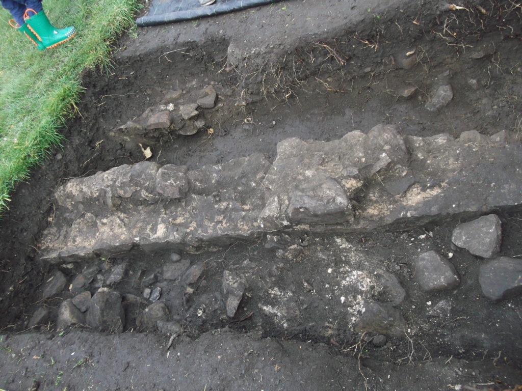
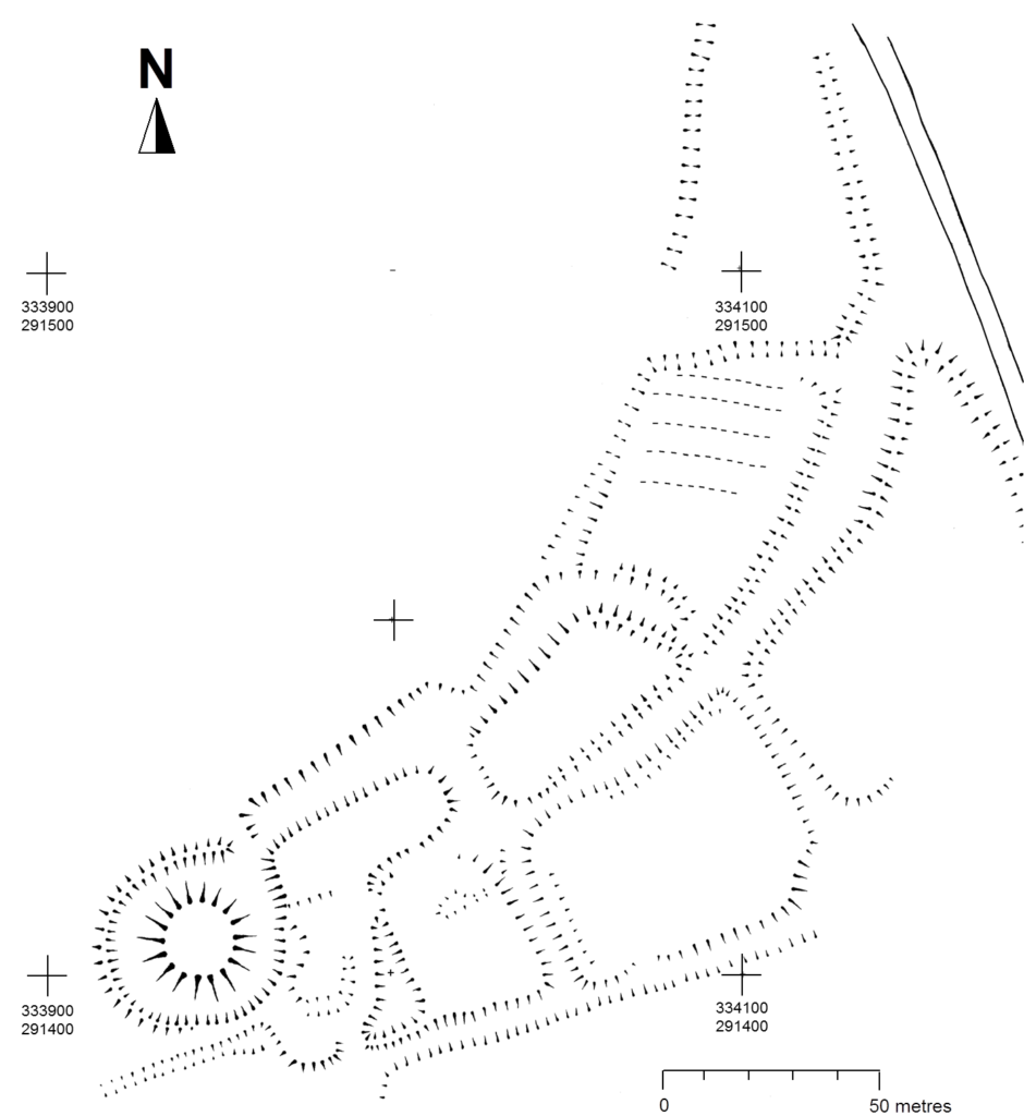
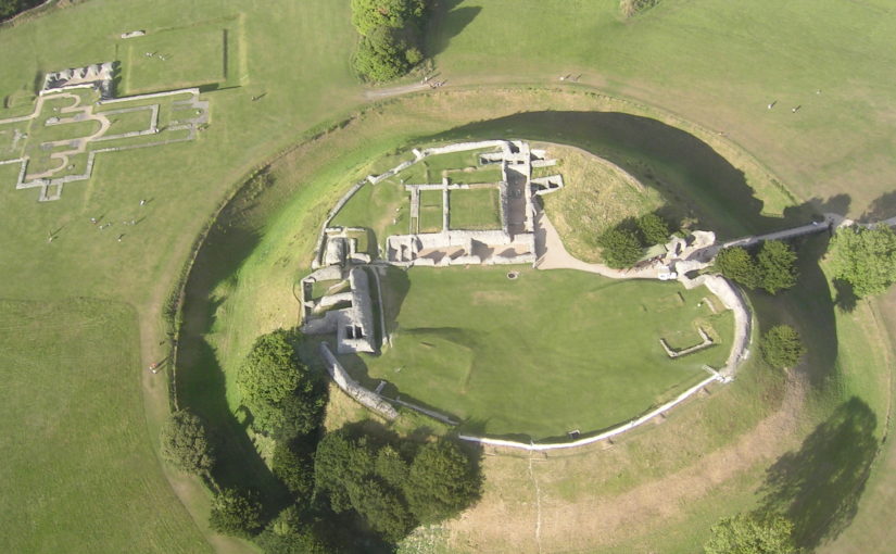
In 2017-2018, The Castle Studies Trust, and the Shropshire Archaeological and Historical Society provided grant-funding for geophysical surveys on the site, together with a level 2 earthwork survey using photogrammetry (Donaldson and Sabin, 2017; Stanford, 2017; Ashby, 2018). The results of this work were informative, and suggestive of a substantial building, measuring 22m by 18m in the inner bailey. Background research, however, drew attention to the wider landscape. It soon became clear that the story of the castle would only be ever half-complete if one focused on the earthworks and buildings of the inner and the outer bailey. The inter-relationship between the motte and bailey, its associated settlement and the parish church of St. Edith was evidently worthy of further exploration (figure 2).
Castle, settlement and church
Pulverbatch is first mentioned in the Domesday Survey of 1086 when it appears as ‘Polrebec’. The name derives from Old English, a combination of pulfre of unknown meaning and bǣce meaning stream valley (Gelling 1990, 245–7). At Domesday, the manor of Pulverbatch, combining both modern settlements of Church and Castle Pulverbatch, was held by Roger Venator [The Hunter]. Roger Venator was a tenant of Roger de Montgomery, Earl of Shrewsbury. Along with his brother Norman, he was a huntsman for the Earl and was consequently granted land in the Shropshire forests. He also held nearby Wrentnall.
Domesday records Pulverbatch as comprising two hides of land which paid tax, and there was land for five ploughs: two ploughs in the lordship with four slaves, while seven villagers had a further three ploughs between them. There were also two ‘radmans’ [riding men – the lord’s servants] in the manor. There was enough woodland for the fattening of 100 pigs. Before 1066, the manor had been worth £6 in tax; that had dropped to 20s in 1066, but by 1086its value had risen to 30s (Eyton 1854, 189).
The evidence suggests that the castle was built towards the end of the 11th century, either by Roger Venator or his son, also called Roger. Castle Pulverbatch is one of eighteen or more earthwork castles in south-west Shropshire that were built by the first Norman lords installed by Roger de Montgomery, himself one of three key lieutenants installed by William the Conqueror following rebellions in the Welsh Marches in the later 1060s. Documentary sources refer to the castle still being occupied in 1205, but there is no trace of a manor-house here in documents of 1292 (Gaydon 1968, 131).
Another motte and bailey lies 1.2km to the south-east, north of Wilderley Hall Farm (Figure 3, site 6), which at Domesday was held by another minor tenant of Roger of Montgomery, Hugh Fitz Turgis (Eyton 1854, 258). Probably, like Castle Pulverbatch, Wilderley was positioned strategically to command a route running northwards from the Long Mynd towards the Severn Valley (Gaydon 1968, 132). Little is known about the history of Wilderley so establishing any chronological link between the two castle sites remains challenging.
In 1254 Philip Marmion was granted the right to hold a weekly market at Pulverbatch on Mondays, and an annual three-day fair around the day [16th September]of St Edith the Virgin’, to whom the church in Church Pulverbatch was dedicated (Eyton 1858, 197).
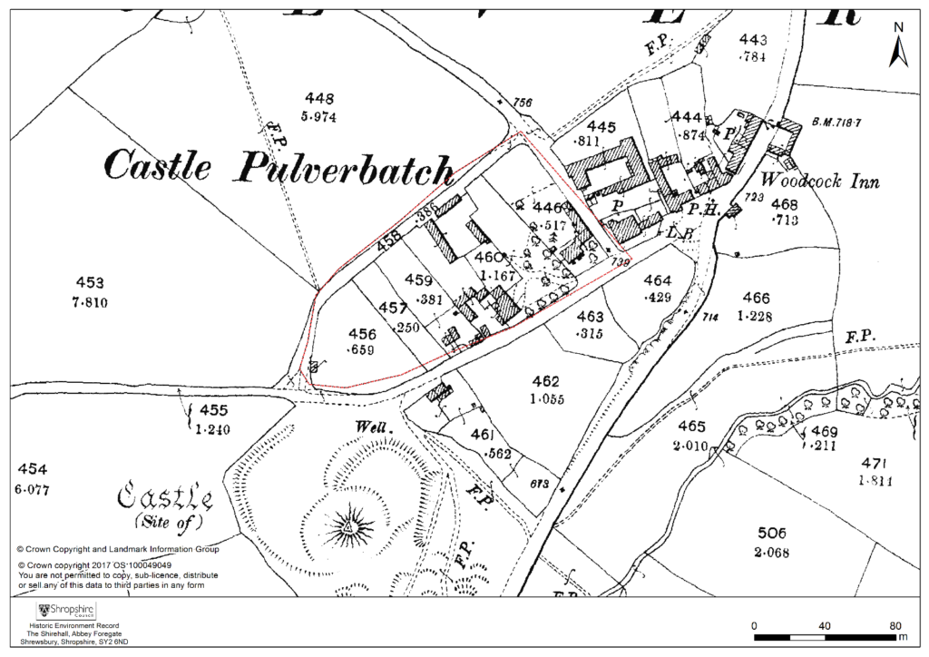
At an inquest on the death of Philip Marmionon January 14 1292, his estate at Pulverbatch included a ‘capital messuage [house, yard, outbuildings and land], a carucate of arable land, and two acres of meadow. A Mill realised 30s…’ (Eyton 1858, 199). The latter was presumably on the site indicated by slight earthworks in a field identified on the tithe map as Upper Mill Meadow (Figure 3, site 3).
There is no clear dating evidence concerning settlement at Pulverbatch. The chronological picture is further complicated by the suggested early date for a church at Church Pulverbatch (Figure 3, site 4). The present building is medieval in origin, although it was largely rebuilt in 1853 (Newman and Pevsner 2006, 203–4). (A lovely watercolour of the pre-19th century form of the church is held by Shropshire Archives, and a small version can be accessed via their online catalogue: https://www.shropshirearchives.org.uk/collections/getrecord/CCA_X6001_19_372B_4)
Figure 4 – 2nd edition 1:2500 Ordnance Survey map of 1903, showing suggested extent of settlement to immediate NE of the Castle site.
The church lies within a circular, embanked churchyard, which has been suggested as indicating an early, possibly pre-conquest origin, drawing upon other examples from the Marches (Rowley 1972, 81), although this hypothesis is untested in the county (see Ludlow 2009, 71-76 for discussion of examples from south-west Wales). A number of other circular churchyards are known in Shropshire (Cardeston, Stanton upon Hine Heath, Llanymynech, Loppington and Leighton, inter alia), but the importance of that at Pulverbatch is heightened by the presence of additional earthworks to the north of the churchyard, occupying a high point within the wider landscape (Figure 2, site 5).
A number of authors have speculated about the development of the medieval settlement sited immediately north and west of the castle (figure 4). Little earthwork evidence survives of this settlement, although a slight bank was recorded in the 1980s by Stillman on a triangle of land known as Pinfold’s Close, directly to the north of the castle’s outer bailey. This triangle was suggested as a possible plot division (see Figure 2, site 2) and subsequently recorded as a property/field boundary by Wendy Horton on a site visit in 1991 (Shropshire HER PRN 03703). Sadly, this area has been extensively disturbed since then, and little trace of any earthworks was found during the 2017-2018 survey work.
Higham and Barker see the village ‘growing up around a castle founded in previously open countryside’ (Higham and Barker 1992, 200) while Rowley suggests that its regularity indicates a deliberately planned settlement unit laid out by the lord of the manor in the 12th or 13th century (Rowley 1972, 86). Creighton goes further in identifying the development at Castle Pulverbatch as representing a nucleation point, “a regular settlement” growing up adjacent to the “new seigneurial centre” (Creighton 2002, 203). This would accord well with the manor of Pulverbatch becoming the caput baroniae, or principal manor of the baronry of Pulverbatch by the end of the 12th century (Gaydon 1968, 131). Stillman suggests that the settlement around the castle may have been a fairly speculative endeavour from the lord of the manor that was ultimately unsuccessful, with settlement shifting downhill to the modern settlement at Church Pulverbatch (Stillman 1980, 18). There is no evidence of the settlement at Castle Pulverbatch ever expanding into ‘anything more than a small farming community’ (Gaydon 1968, 132).
This relationship between the development of a settlement, and the development of a castle site has been little explored in the region. Whilst the extensive work at the motte-and-bailey site of Hen Domen in the 1970s revolutionised our understanding of the likely former structural complexity of timber castles in general (Higham and Barker, 1972), there has been little opportunity to further investigate the significant group of motte and bailey castles in the Vale of Montgomery and SW Shropshire, including inter-relations between settlements and castle.
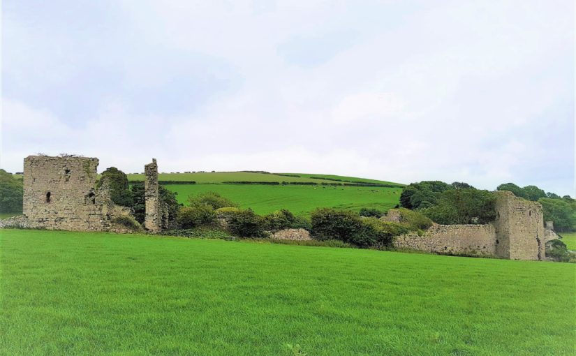
Some of these complexities can be seen at the site of Caus Castle, was subject to a detailed programme of earthwork and geophysical survey in 2016, also funded by the Castle Studies Trust (Fradley and Carey, 2016). Although a castle of quite different status, size and setting to that at Pulverbatch, work here provided evidence of a castle, borough, market (and later fair) in states of flux, and indicated that the fortunes of the castle and the fortunes of the town were not always aligned.
A number of other small, earthwork castles in this part of the march would repay such further study. We might think the castle at More, for instance. A motte and bailey castle developed here from an earlier ringwork castle, with its associated earthwork remains of a deserted settlement, with the remains of house plots and toft boundaries (figure 5).
Non-intrusive landscape survey, as funded by the Castle Studies Trust, allows us to place these sites in some context, and allows a glimpse at the bigger seigneurial, tenurial and topographic picture of these earthwork castles.
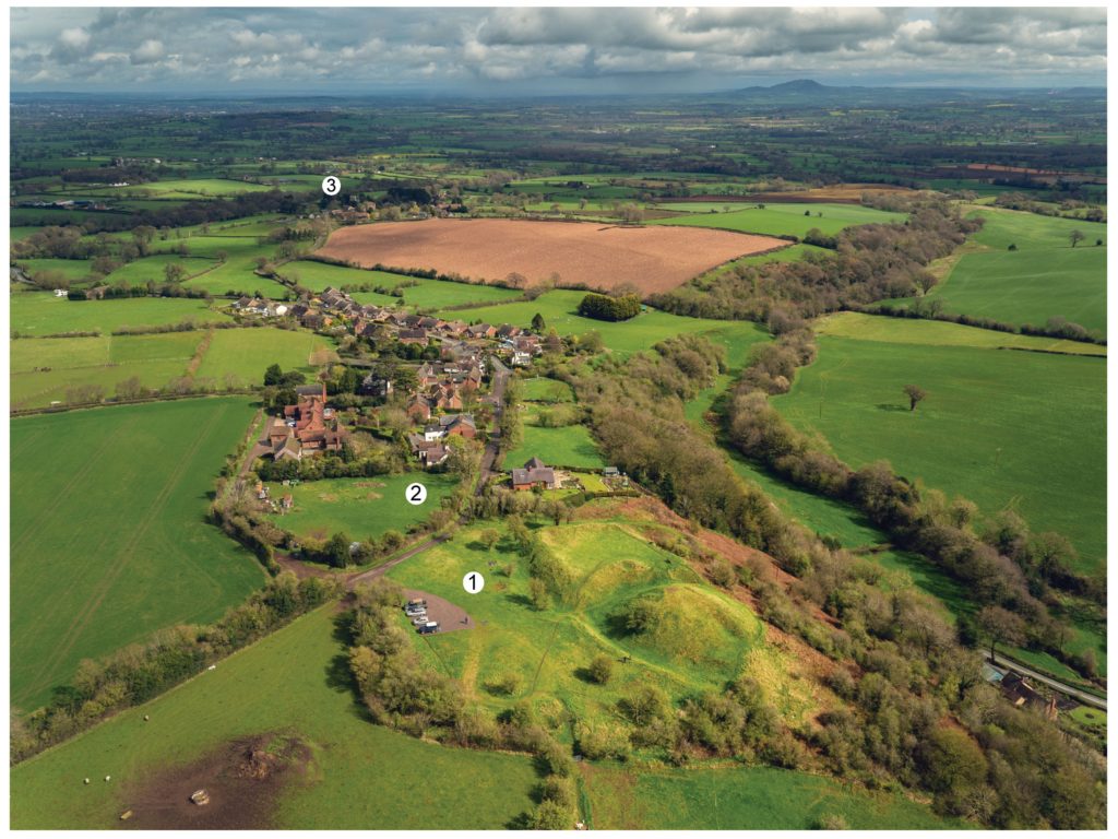
Featured image Castle Pulverbatch bailey from motte top.
Bilbliography
Ashby, D., 2018. ‘Castle Pulverbatch, Shropshire: Ground Penetrating Radar Report’, unpublished report, ARCA, University of Winchester.
Carey, G., 2018. Capturing the Castle: recent survey work at Castle Pulverbatch Motte and Bailey, Shropshire, Transactions of the Shropshire Archaeological and Historical Society93 pp.31-44
Cathcart King, D. and Spurgeon, C., 1965. ‘The Mottes in the Vale of Montgomery’, Archaeologia Cambrensis 114 pp.69–86.
Creighton, O. H., 2002. Castles and Landscapes. London: Continuum
Donaldson, K., and Sabin, D., 2017. ‘Castle Pulverbatch Motte and Bailey, Shropshire: earth resistance & magnetometer survey report’, unpublished report, Archaeological Surveys Ltd., report no. J708. Shropshire HER ESA 8253.
Eyton, R., 1854. Antiquities of Shropshire Volume 6. London. John Russell Smith.
Fradley, M. and Carey, G., 2016. ‘Archaeo-topographical survey: Caus Castle, Westbury — a preliminary report’, unpublished report. Shropshire HER ESA 8179.
Gaydon, A. (ed.), 1968. The Victoria History of Shropshire: Volume VIII. London. Oxford University Press.
Gelling, M., 1990. The Place Names of Shropshire. EPNS, Vols. LXII/LXIII (Part One).
Hannaford, H., and Silvester, R., 2015. ‘Desk-based studies of four castles in the Welsh Marches: Castle Pulverbatch, More Castle, Wilmington Castle & Hyssington Castle’, unpublished report, SCAS, report no. 371. Shropshire HER ESA 7514.
Highham, R. and Barker, P., 1992. Timber Castles. Exeter: University of Exeter Press
Ludlow, N., 2009. Identifying Early Medieval Ecclesiastical Sites in South-West Wales In: Edwards, N. (ed.) The Archaeology of the Early Medieval Celtic Churches London: Routledge, pp.61–84.
Pevsner, N. and Newman, J. 2006. Buildings of England: Shropshire. London: Yale.
Rowley, T. 1972. The Shropshire Landscape. London: Hodder and Stoughton.
Stanford, A., 2017. ‘Castle Pulverbatch Processing Report’, unpublished report, Aerial Cam, report no. C-P-01042017. Shropshire HER ESA 8254.
Stillman, N., 1980. ‘Castle Pulverbatch: a field survey of a motte and bailey earthwork in Shropshire’, unpublished report, University of Birmingham. Shropshire HER ESA 1137.
Thorn, F., and Thorn, C. (eds), 1986. Domesday Book: Shropshire. Chichester
In 2018 Historic England commissioned reports to be carried out on Gleaston Castle near Ulverston, where the Castle Studies Trust have previously funded a survey of the site. The reports commissioned by Historic England were led by Chloe Granger of Crosby Granger Architects, and included a condition survey and concept feasibility study. The feasibility study was aimed at reviewing any potential repair and/or development that could allow the site to become sustainable.
Formerly, in 2015 the Castle Studies Trust grant-funded preparatory works at Gleaston Castle that included a Conservation Statement, geophysical surveys and 3D imagery, to begin the process of understanding more about the castle and its development. From this initial research, the follow-up condition survey and feasibility study prepared by Chloe and her team sets the scene for future repair works and lays the foundations for a potential sustainable future.
Gleaston Castle, listed Grade I and Scheduled under the Ancient Monuments and Archaeological Areas Act, is located on the Furness Peninsula, Cumbria in what appears to be a remote location and strange position for a fortified castle. It is an enclosure castle dating to the 14th century, now a ruin, and has been recorded as such since the mid-16th century. The location on the Furness Peninsula would have historically been less remote, as access was via boat or by crossing the sands of the Morecambe Bay estuary at low tide – a mere short walk.
Gleaston Castle: south east tower interior. Copyright Chloe Granger
The exact date of construction of Gleaston Castle is not known; it was almost certainly built by John Harrington (knighted in 1306) and marked a move from the earlier coastal manorial residence at Aldingham, which had passed to the Harringtons in 1291, possibly in part prompted by early-14th century Scots raids. A date of c1325 is sometimes quoted although the earliest documentary reference is in the 1350s; several sources suggest that it was never finished. It appears to have been abandoned as a manorial residence after the death of Sir William Harrington in 1457 and c1540 it was recorded by Leland as lying in ruins, although some parts may have been re-occupied in the 17th century.
Gleaston is the probably nearest approach to a ‘quadrangular’ castle of a type more common in the North East, and typical of the earlier 14th century. It is not an exact rectangle in plan – the enclosure, 80 m in length north to south, narrows from 55 m at the north end to 45 m at the south. It has had corner towers, with the north-western, by far the largest, clearly containing the hall and subsidiary apartments.
Gleaston Castle: Great Hall from south east tower. Copyright Chloe Granger
The ruinous remains of the castle are in private ownership, incorporated into a working farm, which makes access difficult for the visitor. The structures are in a perilous condition, with falling masonry not an uncommon sight. General vegetation and rigorous ivy are the main culprits. The ivy on the south-east tower is known to Historic England as the largest, most substantial and ancient ivy known on a structure in the country. The scale of the issue is enormous. There is no management plan and no funding to enable a comprehensive strategy of repair to be carried out to safeguard the structures.
Gleaston Castle: entrance to sw tower. Copyright Chloe Granger
Through Chloe, the Society for the Protection of Ancient Buildings (SPAB) have become involved and are planning a working party to begin to make a start on rescuing the castle. It is a colossal task, but the aim of the working party will be to raise awareness and put Gleaston castle on the map, which the team hopes will generate support for the cause. The volunteer working party team is hoping to carry out some initial vegetation clearance and some consolidation, with professionals offering their time pro-bono; the first required are an ecologist and an arboriculturalist. The initial working party is planned for September,
If anyone is interested in either contributing time or funds, your support would be greatly appreciated! For more information contact Chloe Granger on chloe at crosbygrangerarchitects dot co dot uk
Sara Cockerill, author of the recently published biography of Eleanor of Aquitaine, looks at her role in English castle development.
One of the areas which has stayed slightly “off-camera” as I have written about Eleanor is the question of her relationships with the castles of her era. The headlining castles built under Henry’s aegis show no signs of Eleanor’s input. More intriguing however, is her relationship with those castles which pre-dated Henry’s reign and which found themselves in need of a bit of TLC – not necessarily from a military point of view, but in order to function as homes as well as defences. Where this sort of work is concerned there seems to be some ground for tracing a link between Eleanor’s regencies and the initiation of refurbishment programmes.
To start with the most obvious example – the Tower. On Eleanor’s first arrival in London the Tower was uninhabitable, and the royal couple had to stay instead at Bermondsey Abbey. While it is clear that Henry II put Thomas Becket in charge of refurbishing the equally run down Palace of Westminster, money does not commence to be spent on the Tower until 1166 – during Eleanor’s regency, suggesting that she had some hand in the decisions as to its refurbishment. Quite what these were is of course a matter of some debate, but they included as well as defensive works, quasi domestic features, such as work to the chapel and living accommodation.
Another castle which came under Eleanor’s review is Berkhamsted – initially given to, and refurbished by Becket, it was transferred to Eleanor, who held the barony as part of her dower assignment, during the course of Henry’s quarrel with Becket, with the royal family spending Christmas of 1163 there; an event which involved numerous items of plate being sent from Westminster to dress the rooms to best advantage. In the years which follow, again during Eleanor’s regency, there is regular work noted in the accounts, on the “Kings houses” there, at the granary, the bridges – and the lodgings. Her interest in the property is further evidenced by her travelling to stay there as soon as she gained a greater measure of freedom in 1184, with the advent of her daughter Matilda, then in exile from Saxony. Eleanor and Matilda’s family seem to have spent the whole summer there. And finally – work stops on the castle just at the period when Eleanor departs to her retirement in Poitou. However even in retirement her steward for the Berkhamsted estate would travel to visit her at Fontevraud….
Berkhamsted Castle bailey from the motte including remains of buildings built in Eleanor’s regency
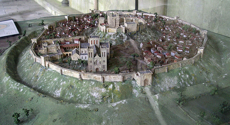
Other places where Eleanor was particularly at home and where her interest can be traced are Old Sarum (Salisbury) and Winchester – her main locations during her captivity. But everything suggests that she was sent there not because she disliked them, but rather the reverse. Both are places she positively chose to visit on more than one occasion as regent in the 1150s and 1160s. Winchester, of course, was Henry I’s main residence, and had benefitted from a constant programme of renewals ever since. Interestingly however its domestic architecture was thoroughly overhauled from the year after Eleanor arrived in England. In 1155–6 £14 10s. 8d. was paid for making the king’s house and the next year another £14 10s. was spent for work on just one chamber in the castle. In 1170 £36 6s. was paid, and in 1173 £56 13s. 1d. was paid for work on the king’s houses at Winchester and £48 5s. for work on the castle and provisioning it. Large sums of money were, interestingly paid for the King’s chapel, in the years when Eleanor was a frequent resident there in confinement. To this period too can be traced the first indications of development of the gardens. Old Sarum for its part had a residential area which was modern, having been built as recently as 1130 under the aegis of the then bishop. During Eleanor’s residence at Salisbury in the 1170s and early 1180s, there was consistent expenditure including £47 on the houses in the year Eleanor came to live there. That Eleanor positively liked Salisbury is shown by the fact that after her release she chose to organise the wedding of André de Chauvigny to the heiress Denise of Déols there; and Winchester too was a voluntary stop for her more then once in her later years.
Old Sarum from the west in C12, (Model: John B. Thorp. Photo: Kurt Kastner)
In a similar category is Windsor castle. Though predominantly a project of Henry’s – the defensive remodelling smacks of his planning – Eleanor spent considerable periods of time here – bearing Matilda here when the castle must have been a building site, and visiting repeatedly both as regent when she may well have had a hand in the development of the domestic buildings, which were to form a family base for her descendant Henry III’s family. Again it is a castle she seems to have positively chosen to visit with Matilda on Matilda’s return, and again following her release.
Although of course Berkhamsted has fallen into disrepair, one can perhaps therefore trace Eleanor’s hand in creating a core of castles which could double as homes, which was to influence the lives of generations to come.
Featured image: Aerial photograph of Old Sarum site, on departure from Old Sarum airfield by Mark Edwards.
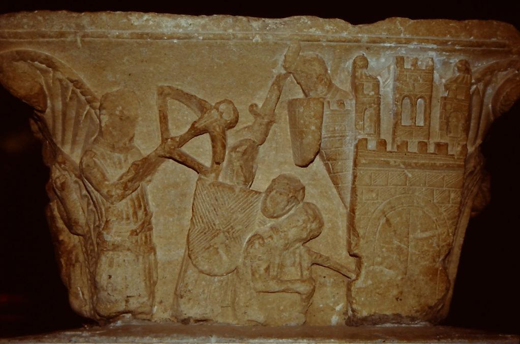
Dr Peter Purton FSA, leading expert on medieval siege warfare examines one of the most famous British medieval sieges, that of Rochester in 1215.
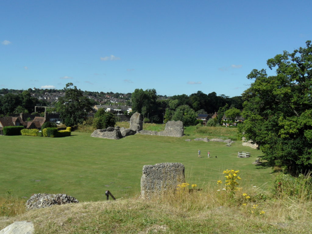
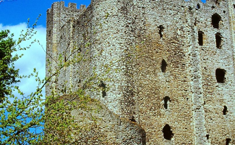
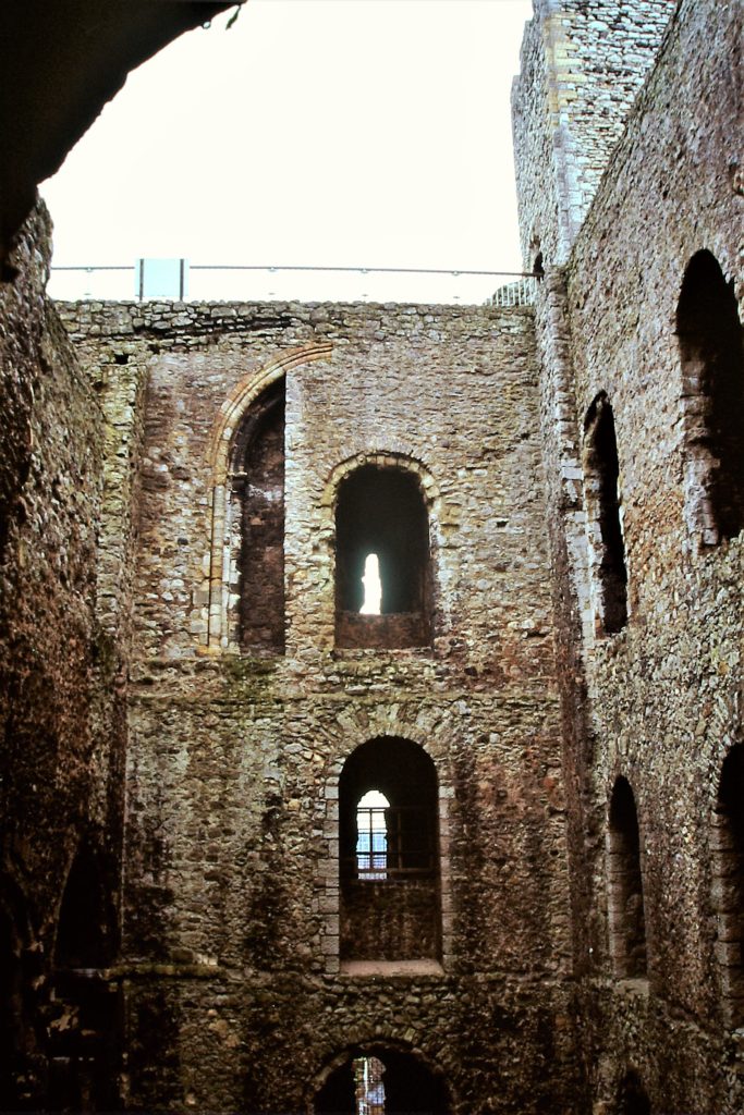
The great donjon of Rochester castle (Kent) is still visible from miles around – including from the Eurostar. It stands above a bridge across the tidal waters of the river Medway and that was one reason why it was subject to a famous six- week siege which ended when an entire corner of the great tower was brought crashing to the ground, leading to the fall of the castle on 30 November 1215.
This was the first big battle in the civil war that broke out between King John (1199-1216) and the barons who had forced him to seal Magna Carta in June of that year. The king got the pope to declare it null and both he, in the south, and the barons, based in London, began to gather soldiers. We know a great deal about what happened because contemporary chroniclers, including eyewitnesses and those closely associated with men fighting there, wrote it down; and because some government records survive. We know the names of the nobles and many of the knights on both sides, of the engineers paid to construct the King’s five stone-throwing siege engines, and the master miners from the Forest of Dean who with their team (altogether 13 miners) undermined first the wall of the bailey and then the great tower itself.
Sappping a tower: Foix castle museum
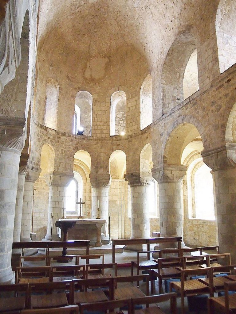
The first castle was built after the Norman conquest but the great tower dated from 1127 when it was built for the archbishop of Canterbury, then William of Corbeil, who shared ownership and use with the crown. It is the tallest keep in the British Isles (125 feet, 38 metres) and unusually boasts two floors above the main level and basement below, divided vertically by a spine wall that gave access to the castle well. Richly provided with latrines and comfortable chambers, two spiral staircases, beautifully decorated stonework, it was a place fit to entertain king or archbishop. But in 1215 none of this mattered, archbishop Stephen Langton ignored John’s demand to hand it over and instead allowed rebel baron William de Albini and 60 or 80 knights, their retinues and archers and crossbowmen, to take possession.
Interior of Rochester’s keep showing the rebuilt corner. To the left is the spine wall the defenders fell back to after the sapping
Control of the ancient bridge over the Medway was vital for both sides, and so it became John’s first target once he had gathered an army of several thousand experienced fighters mainly from Flanders, Poitou and Gascony. The defenders resisted every attack for weeks, inflicting many casualties on John’s men. In the end the besiegers turned to their miners, who first broke through the bailey wall (we don’t know where), then, using the grease from 40 slaughtered pigs (‘of the kind not fit for eating’) as an accelerant to burn the props they had used to prop up the masonry while they sapped the south east corner turret of the great tower, brought it crashing down. The defenders retreated behind the spine wall but had run out of food so surrendered. King John wanted to hang them all but was dissuaded by his own captains who didn’t want to meet the same fate if the wheel of fortune should turn against them.
To this day one can see the join on the sides of the donjon where the wall had to be rebuilt after the siege.
In 2015 the Castle Studies Group (www.castlestudiesgroup.org.uk) held a conference there to mark the 800th anniversary and I presented a short paper analysing the siege. Now, following an invitation from across the Atlantic, an extended and illustrated version of that talk can be viewed at:
Castle Studies Trust’s expert grant assessor Erik Matthews reveals the findings of the 10 years (and counting) excavation he has been directing of Hornby Castle in Wensleydale North Yorkshire.
A programme of
archaeological fieldwork involving excavation with some building recording has
been in progress since 2010 with the new season due to commence as soon as
conditions will allow. It has focussed on the site of a moated hunting lodge of
the Dukes of Brittany referred to in a Charter dated to 1115. It was
subsequently used as a “pleasaunce” for first the Nevilles of Redbourne in
Lincolnshire and later the Conyers
before its destruction in a military attack at the end of the Wars of
the Roses.
Pre-conquest origins
Recent work has focussed on the kitchen where
oven structures have been recovered with traces of a wooden tank for holding
live fish prior to their cooking. A stone sink with a wooden drain leading into
the moat to the north has been found with a cherry stone recovered from it. There
was also traces of a fireplace which collapsed with the remainder of the
building sending a plume of ash into the room. Following the discovery of
residual artefacts of Pre-Conquest date from the kitchen floor including a
carved walrus ivory handle, a sherd of Pre Conquest glazed pottery made in
Northern Germany and piece of fine
worked bone casket, it was decided to section the floor to find evidence of an
earlier structure beneath. Evidence of a wooden floored, stave walled structure
was found which may be associated with the immediate Pre-Conquest tenant
Arnekill who was of noble birth and related to the Earls of Northumbria.
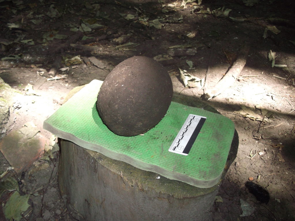
Examination of the remains of the kitchen front wall yielded evidence of the ferocity of the destruction of the complex with the recovery of a large stone cannon ball (below)from a heavy calibre cannon which had become embedded in it. Close by a carved Nidderdale marble capital was found which has been dated to the 12th Century and which may have come from a chapel in nearby.
Stone canon ball found in the kitchen front wall (copyright Erik Matthews)
The Great Tower – post medieval survival?
The 2019 season focussed on a section of the moat which
located traces of a stone bridge abutment and wooden foot bridge surviving in
the moat silts heading towards an earthwork in an adjacent field. The main discovery has however been evidence
of an ashlar clad stone Great Tower. Two wall foundations 2.8 metres wide sunk
into a rock clad mortar embankment rising some 1.2 metres have been located to
the north and west. The north wall includes the remains of a robbed out spiral
stair. Internal features include an internal chamber with very thick walls
which may have been a strong room, also a corridor from the floor of which an
iron knife was recovered blade down! Evidence of an external doorway heading to
the north towards the area of the most bank has been recovered and a small
section of roofing lead together with lime slurry suggests an impressive
structure. The close proximity of the foundations to the modern ground surface
suggest tantalisingly that the structure may have survived as a ruin into the
relatively recent past.
For more information about the excavation please contact
Erik Matthews on rubyna dot matthews at btinternet dot com
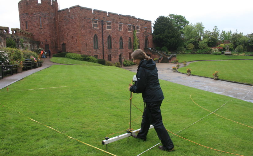
Project lead for the Shrewsbury Castle excavations Dr Nigel Baker looks forward to the forthcoming excavations at the castle, hopefully this year, funded by the CST
Last
year, the Castle Studies Trust excavation – the first ever to have taken place
within the walls of Shrewsbury Castle – produced three headline conclusions.
The first was that the work of the young Thomas Telford there for his client,
William Pountney M.P. in 1786-90 was, sadly, more destructive of the medieval
original than had previously been recognised. The extent of his restoration of
the house (now the Soldiers of Shropshire Museum) and the curtain walls has
long been known. What wasn’t appreciated was that standing walls of ruined
buildings and a 13th-century tower on the motte top were destroyed
and reduced to their footings, and the interior of the inner bailey was, it
seems, scraped flat, producing a lovely level lawn at the expense of any archaeological
deposits overlying the natural gravel of the hilltop. Despite this, infilled
negative features (pits and ditches) cut into the gravel survived and were
found by our excavation trench. As a result, our second headline conclusion was
that the motte was ringed on its landward side by a massive ditch, twelve
metres wide: what we know as the inner bailey must, in the early Middle Ages,
have been little more than a barbican defending the end of the bridge giving
access up the motte.
C18
Remodelling?
But
the extent of Telford’s work raises a question, first put to the archaeological
team by Martin Roseveare, our geophysicist: if Telford had the inner bailey
levelled flat, where did he put the proceeds, meaning the scraped-up earth and
debris? Could the apparently well-preserved medieval ramparts ringing the
bailey actually be down to the young Scottish civil engineer, rather than
impressed English labour under the whip-hand of William the Conqueror’s
henchmen? This is one of the leading questions that a second season of
excavation at Shrewsbury Castle hopes to be able to answer, by digging on part
of the western rampart known to be already disturbed by former Victorian
greenhouses.
High
Status Saxon Living
There
are, however, other at least equally compelling reasons for excavating on this
site. The third headline conclusion of the 2019 trench was that there was
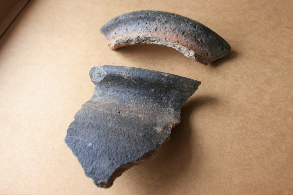
pre-Conquest activity within the area of the inner bailey. This was
demonstrated by a pit, pit 20, containing Stafford-type ware (well known in
late pre-Conquest Shrewsbury) and a type of pottery known as TF41a, an import
up the Severn from Gloucester, never seen before in Shrewsbury. The question
is, what was it doing there?
Top piece Rim of type 41a Saxon pottery from Gloucester Lower piece: Rim of Stafford ware Saxon pottery
Shrewsbury
is one of those castles listed in Domesday along with the destruction it caused
to its ‘host’ shire town. Construction of Shrewsbury Castle took out 51
tax-paying tenements, a quarter or a fifth of the total built-up area, to the
economic distress of the remaining inhabitants. Many of the destroyed plots
will have lined the strategically important Chester to Hereford road that
passes through the outer bailey. However, looming over the road and its plots,
and the main gate through the pre-Conquest defences, was the hilltop on which
the castle would come to be built. And on it, overlooking the gate, most likely
on the Victorian greenhouse site, was the Church of St Michael, a church that
became the castle chapel, but was listed in Domesday between the entries for
two of the town’s pre-Conquest minsters and was served by two priests later in
the Middle Ages, when it was a royal peculiar, exempt from episcopal oversight.
This need not necessarily all add up to a pre-Conquest church – but the chances
are very strong that it does, and that this church, which, overlooking the town
defences, may have had some kind of
defensive role, was part of the context of pit 20.
The
clues are beginning to point to a high-status site, probably enclosed, with its
interior ground level two metres above that of its neighbours, and its own
church. For an analogy, one could do worse than look to Wallingford, whose
castle in the north-east corner of the Saxon burh had probably taken over and
re-fortified a royal site of some kind, possibly housing government functions,
perhaps a mint, and a garrison of housecarls. Or one might look to Oxford,
where St George’s Tower is now generally thought to be of pre-Conquest date. Shrewsbury
seems to be joining the list of Norman town castles established on sites of
political, not just tactical, importance.
But archaeology can be frustrating. While we hope that excavation of the Victorian greenhouse site in the west rampart may yield insights into the extent of Thomas Telford’s landscape gardening, the foundations of a pre-Conquest church and further clues to a high-status or even royal site preceding the castle, by 2021 the excavation team may well be singularly well-informed experts on…Victorian greenhouses.